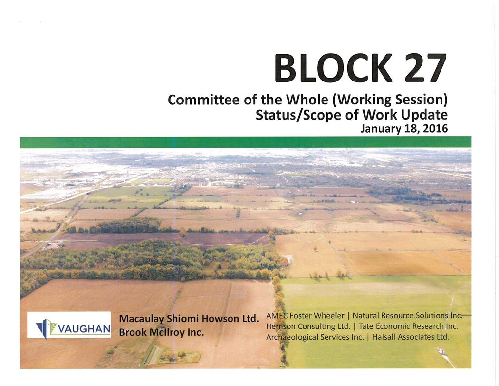
CITY OF VAUGHAN EXTRACT FROM COUNCIL MEETING MINUTES OF FEBRUARY 16, 2016
|
|
|
- Maude Warren
- 5 years ago
- Views:
Transcription
1 CITY OF VAUGHAN EXTRACT FROM COUNCIL MEETING MINUTES OF FEBRUARY 16, 2016 Item 4, Report No. 4, of the Committee of the Whole (Working Session), which was adopted, as amended, by the Council of the City of Vaughan on February 16, 2016, as follows: By approving that landowner groups along with the Public and Catholic School Boards revisit and report back with a more realistic request for lands to be set aside for schools. Regional Councillor Di Biase declared an interest with respect to this matter as his children own land in Block 27 given to them by their maternal Grandfather, and did not take part in the discussion or vote on the matter. 4 NEW COMMUNITY AREA BLOCK 27 SECONDARY PLAN STUDY STATUS UPDATE REPORT AND DIRECTION TO INCREASE SCOPE OF WORK FILE: WARD 1, VICINITY OF JANE STREET, KIRBY ROAD, KEELE STREET AND TESTON ROAD The Committee of the Whole (Working Session) recommends: 1) That the recommendation contained in the following report of the Deputy City Manager, Planning & Growth Management and the Director of Policy Planning & Environmental Sustainability, dated January 18, 2016, be approved; 2) That the appropriate consultants be directed to revisit the issue of the inclusion of neighbourhood commercial centres internal to residential blocks, particularly in respect to matters such as location, size and diversity of services sufficient to ensure on-going sustainability as evidenced by such centres as those found at: Fiori Drive and Chancellor Drive Embassy Avenue and Aberdeen Avenue and Ansley Grove Road and Aberdeen Avenue and other such centres; 3) That the presentation by Ms. Elizabeth Howson, Principal, Macaulay Shiomi Howson Ltd., Annette Street, Toronto, and Communication C3, presentation material titled Block 27 Status/Scope of Work Update, dated January 18, 2016, be received; and 4) That the following deputations and Communication be received: 1. Mr. John Bousfield, Bousfield Inc., Church Street, Toronto, representing Block 27 Land Owners Group, and Communication C2, dated January 15, 2016; and 2. Ms. Gloria Marsh, Executive Director, York Region Environmental Alliance, Dariole Drive, Richmond Hill. Recommendation The Deputy City Manager, Planning & Growth Management and the Director of Policy Planning & Environmental Sustainability, in consultation with the Director of Development Engineering & Infrastructure Planning recommend: 1. THAT this status report and accompanying presentation on the progress of the Secondary Plan Study for the Block 27 New Community Area be received for information purposes; /2
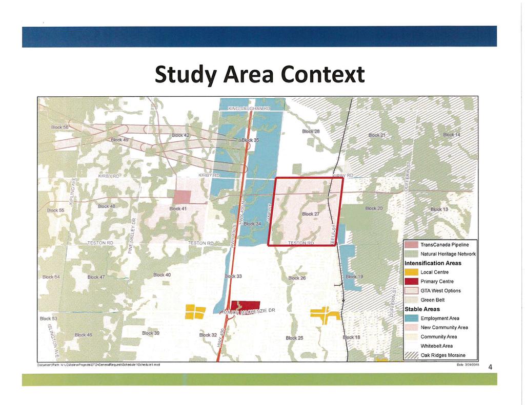
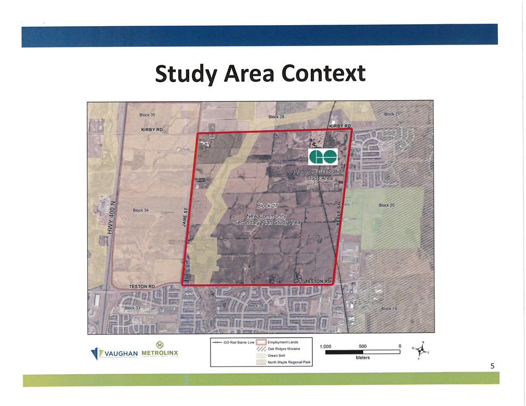
2 CITY OF VAUGHAN EXTRACT FROM COUNCIL MEETING MINUTES OF FEBRUARY 16, 2016 Item 4, CW(WS) Report No. 4 Page 2 2. THAT staff be directed to work with the Landowners Group, York Region and Metrolinx to prepare a Terms of Reference for a Mobility Hub Study that includes the conceptual design of a proposed GO Station in Block 27 and Kirby Road upgrades adjacent to Blocks 27 and 28, to inform future Environmental Assessment requirements associated with the GO Station, Kirby Road, and the ongoing Metrolinx Regional Express Rail Study. Contribution to Sustainability The Block 27 Secondary Plan must be consistent with the policies of the Region of York Official Plan, Places to Grow: the Provincial Growth Plan for the Greater Golden Horseshoe, The Big Move Regional Transportation Plan, the Vaughan Official Plan 2010; and, with Green Directions Vaughan, the Community Sustainability and Environmental Master Plan respecting sustainable development and the creation of complete communities. Economic Impact The funding for the Block 27 Secondary Plan study was approved in the 2013 Capital Budget as Project PL with a budget of $515,000. Staff are recommending that a Terms of Reference for a more detailed study of the GO Station mobility hub, and Kirby Road west of Keele Street and surrounding area (as shown on Attachment 4), to ensure the City and Region can continue to respond to the findings of the Metrolinx Regional Express Rail initiative. Staff anticipates that the City portion of the additional work will be funded from the City-Wide Development Charges (CWDC)-Management Studies (90%), and Professional Fees (10%). The landowners groups in Block 27 and Block 28 would be expected to provide support including technical input to inform this effort. The financial impact will be determined in more detail once the scope of work is finalized. Communications Plan A courtesy non-statutory meeting notice was sent via on January 4, 2016 to the Block 27 Landowners and those previously requesting notification and updates on the progress of the Block 27 Secondary Plan Study. The notice was also advertised on the Policy Planning and Environmental Sustainability departmental webpage for the New Community Areas and on the Vaughan City Page On-line. Purpose To provide Council and interested stakeholders with an update on the progress of the Block 27 Secondary Plan; and, to obtain direction to prepare the terms of reference for the detailed study of the GO Station and Kirby Road upgrades, that will inform Environmental Assessment requirements associated with the Station, Kirby Road and the ongoing Metrolinx Regional Express Rail initiative. Background - Analysis and Options Executive Summary The Block 27 Secondary Plan Study is proceeding on schedule. This report outlines the Draft Emerging Land Use Concept and the proposed work program to further refine the Plan prior to approval. The report discusses and recommends an additional study opportunity to advance Council s objective of achieving a Go Train Station at Kirby Road. This more detailed study will inform and better position the City and Stakeholders to respond to the Regional Express Rail initiative. This report is structured into sections which provide the following information: /3
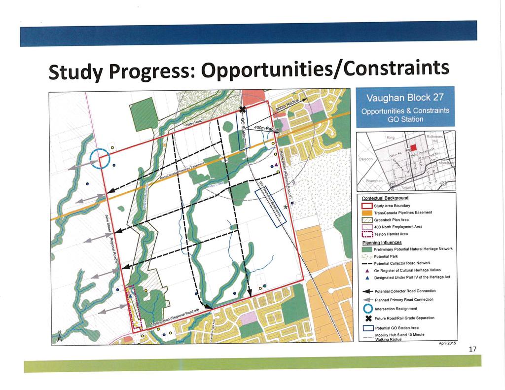
3 CITY OF VAUGHAN EXTRACT FROM COUNCIL MEETING MINUTES OF FEBRUARY 16, 2016 Item 4, CW(WS) Report No. 4 Page 3 (1) A description of the study area and land use context; (2) A description of the Provincial, Regional and municipal policy framework guiding the development of the Secondary Plan; (3) The public and agency consultation process to date; (4) Study progress and work completed to date; (5) The draft Land Use Concept and related issues; (6) Rationale for detailed study of mobility hub area in response to evolving circumstances; (7) Status of the supporting studies; (8) Next Steps in the study process; and (9) Conclusion leading to the report s recommendation. (1) Location and Context The Block 27 area, as shown on Attachment 2, is bounded by Teston Road to the south, Keele Street to the east, Kirby Road to the north and Jane Street to the west. The subject lands are surrounded by the following uses: North - Kirby Road; Greenbelt; Agricultural South - Teston Road; existing Low-Rise Residential East - Keele Street; existing residential and employment lands; proposed north Maple Regional Park West - Jane Street; approved Highway 400 North Employment Lands The Block 27 lands have a total area of approximately 400 ha and are primarily rural in nature, with some existing residential and institutional uses. A portion of the Greenbelt traverses the block north to south, including a main tributary of the West Don River Sub-watershed. Also located within the Block 27 boundary is the TransCanada Pipeline which runs east-west in the northern portion of Block 27 as shown on Attachment 2. In addition, the Barrie GO Rail line runs north-south along the eastern portion of the Block, with the proposed station site being located in the vicinity of Kirby Road. (2) Policy Context The York Regional Official Plan (YROP) and the Vaughan Official Plan (VOP 2010) were developed under the broader policy framework provided by the Provincial Policy Statement, the Growth Plan for the Greater Golden Horseshoe, and the Greenbelt Plan. The policies arising from the Secondary Plan Study for New Community Area Block 27, must be consistent with each of these Provincial, Regional and municipal policy frameworks. The following policies provide high level guidance on the desired outcome. a. The Provincial Policy Statement 2014 (PPS 2014) The Provincial Policy Statement 2014 (PPS 2014) provides policy direction on land use planning to promote strong communities, a strong economy, and a clean and healthy environment. Part IV, Vision of Ontario s Land Use Planning System of the PPS 2014 further states: i. Land use must be carefully managed to accommodate appropriate development to meet the full range of current and future needs, while achieving efficient development patterns (S. 1.0); ii. Efficient development patterns optimize the use of land, resources and public investment in infrastructure and public service facilities (Part IV) ; iii. Efficient use of existing and planned infrastructure, including the use of transportation demand strategies where feasible (S ); maintain or improve the connectivity within and among transportation systems and modes, where possible (S ), /4
4 CITY OF VAUGHAN EXTRACT FROM COUNCIL MEETING MINUTES OF FEBRUARY 16, 2016 Item 4, CW(WS) Report No. 4 Page 4 encourage and support a land use pattern, density and mix of uses which minimizes length and number of vehicle trips, and supports the current and future use of transit and active transportation (S ). b. Places to Grow: The Growth Plan For the Greater Golden Horseshoe (GGH) The Growth Plan for the Greater Golden Horseshoe (GGH) promotes strong, prosperous communities by managing growth to the year It also builds on other provincial initiatives such as the Greenbelt Plan and the PPS While emphasizing opportunities to enhance and intensify existing communities, the Growth Plan provides guidance for designated Greenfield Areas, such as Block 27, which have been identified for future residential growth. Under Section of the GGH Plan, new community areas are intended to be welldesigned, offer transportation choices, and accommodate people at all stages of life. They are expected to provide a mix of housing types along with easy access to stores and services, to meet daily needs. c. Greenbelt Plan The Greenbelt Plan designates a portion of the Block 27 area as Protected Countryside, which includes Agricultural and Natural Systems, together with settlement areas which are subject to the policy of Section 4.0 of the Plan. Hamlets as identified in municipal official plans continue to be governed by municipal official plans and related programs and are not subject to the policies of the Greenbelt Plan except for external connections (s.3.4.3). The Greenbelt Plan designations and policies are reflected in the YROP and the VOP d. The Big Move, 2008 (Metrolinx) Regional Transportation Plan In November 2008, Metrolinx adopted a Regional Transportation Plan, entitled The Big Move: Transforming Transportation in the Greater Toronto and Hamilton Area to tackle gridlock across the Greater Toronto and Hamilton Area (GTAH). The Plan provides for the development of an integrated transit and transportation system to better move people and goods. The Regional Transportation Plan sets out a 25 year vision. It is guided by a set of 13 goals and related objectives which are designed to achieve a more efficient and sustainable transportation system for the GTAH. It is noted that many of the objectives will help to achieve more than one goal. The goals and objectives are intended to provide guidance for decision-making and planning at all levels, including the provision of Transit Oriented Development, to support system development. In order to fulfill this mandate, The Big Move has established a number of strategies. Schedule 1 15 Year Plan for the Regional Rapid Transit and Highway Network outlines a plan to build a comprehensive regional rapid transit network that operates seamlessly across the region. The 15 year plan for regional rapid transit identifies all day, two-way Regional Rail service through Block 27. The policies indicate that this rapid transit network must be incorporated in all municipal Official Plans and as noted above, this is currently reflected in the YROP and the VOP Both Official Plans also identify the potential for a GO Rail Station in the vicinity of Kirby Road and Keele Street. /5
5 CITY OF VAUGHAN EXTRACT FROM COUNCIL MEETING MINUTES OF FEBRUARY 16, 2016 Item 4, CW(WS) Report No. 4 Page 5 Another strategy established in The Big Move is to build communities that are pedestrian, cycling and transit supportive, recognizing that people who live in higher density neighbourhoods with services nearby are more likely to walk, cycle or take transit. The Big Move acknowledges that the interface between urban form and transportation is particularly important around transit stations, therefore growth and development should be focused around major transit stations to allow more people to live near transit and to make more destinations accessible by transit. An intent of the Big Move is to create a system of connected mobility hubs at key intersections in the regional rapid transit network. The Plan identifies a Mobility Hub as a major transit station area, as defined in the Growth Plan for the Greater Golden Horseshoe. It is a place of connectivity between regional rapid transit services, and also a place where different modes of transportation, from walking to high-speed rail, come together seamlessly. It has, or is planned to have an attractive, intensive concentration of employment, living, shopping and amenities around a major transit station. To be identified as a mobility hub, a major transit station area must be located at the interchange of two or more current or planned regional rapid transit lines and be forecast to have a combination of 4,500 or more people boarding and alighting in the morning peak period in In addition, a mobility hub is generally forecast to achieve or have the potential to achieve a minimum density of approximately 10,000 people and jobs within an 800 metre radius. Metrolinx Mobility Hub Guidelines (September 2011) As part of the implementation of the Big Move, Metrolinx has prepared Mobility Hub Guidelines to communicate the objectives, characteristics and role of Hubs and provide guidance on the development of Mobility Hubs. The Guidelines identify the following objectives: Seamless Mobility: o Seamless integration of modes at the rapid transit station o Safe and efficient movement of people with high levels of pedestrian priority o A well-designed transit station for a high quality urban experience Placemaking: o Strategic parking management o A vibrant mixed-use environment with higher land use intensity o An attractive public realm Successful Implementation: o A minimized ecological footprint o Flexible planning to accommodate growth and change o Effective partnerships and incentives for increased public and private investment The mobility hubs identified by the Big Move are all a type of major transit station area. The Growth Plan requires that municipalities plan these identified areas with densities that support the existing and planned rapid transit infrastructure. The Mobility Hub Guidelines provide suggested density thresholds for the different mobility hub typologies. Table ii.3 of the Mobility Hub Guidelines provides Hub typologies. The Mobility Hub Guidelines indicate the following characteristics for Regional Rail mobility hubs: /6
6 CITY OF VAUGHAN EXTRACT FROM COUNCIL MEETING MINUTES OF FEBRUARY 16, 2016 Item 4, CW(WS) Report No. 4 Page 6 Expansion, as envisioned in The Big Move, includes improving service from peakdirection and period rail service to all-day, two-way service. Land use density and mode share targets should reflect the existing and planned service levels for regional rail corridors. In most cases, Regional rail attracts the majority of its riders from a large catchment area beyond the mobility hub. As a result, ridership is less sensitive to the densities within the hub. Suggested transit supportive densities (includes residents and jobs combined per hectare, within a mobility hub) ranging between persons. Suggested transit mode share (trips originating within mobility hub) ranging between 10 25%. While currently lacking the interconnection to a second Regional rapid transit service, transit service on Keele Street is already available. Therefore, a Block 27 GO Rail Station can be designed to meet many of the mobility hub guidelines. This opportunity is being investigated through the Secondary Plan Study. This study is occurring concurrently with the Metrolinx Regional Express Rail Environmental Assessment (electrification, 2 way-all day service and double tracking) and an assessment of potential station sites system wide. The Kirby Road station has been identified as a site for further study. The City, Region and landowners are working with Metrolinx to coordinate the Environmental Assessment Act approval and Planning Act approval processes. The Block 27 Secondary Plan is being prepared to accommodate a Kirby Station, including meeting the mobility hub guidelines for a GO Rail Station. e. York Region Official Plan (YROP) The New Community Area policies of the YROP focus on creating sustainable communities with a pedestrian friendly, transit supportive transportation system that will reduce reliance on automobiles. Section 1.2 Towards A Sustainable Region, establishes a framework for achieving sustainability and rethinking the way communities are designed, serviced and supported. Section 5.6 titled Building Complete, Vibrant Communities references the new community areas as places where people interact, learn, work, play and reside. Excellence in community design is essential to creating a physical place where people have the opportunities and choices required to lead rewarding lives. Furthermore, with respect to the New Community Areas, it is the policy of Regional Council that, local municipalities, in consultation with York Region, prepare comprehensive Secondary Plans for New Community Areas that meet or exceed the policies of this section of this Plan. The Secondary Plan preparation should include an innovative approach that involves a multidisciplinary team assembled by the local municipality in order to ensure an integrated and sustainable approach to the planning, design and approval of the Secondary Plan. f. The York Region New Community Guidelines (YRNCG) The YRNCG were created to assist local municipalities and the development industry in successfully implementing the YROP (2010) New Community Areas (section 5.6) and Sustainable Buildings (section 5.2) policies. As such the Guidelines address the York Region Official Plan policy directives by providing checklists and more specific requirements for each of the following general policy objectives. /7
7 CITY OF VAUGHAN EXTRACT FROM COUNCIL MEETING MINUTES OF FEBRUARY 16, 2016 Item 4, CW(WS) Report No. 4 Page 7 i. To build complete communities through a comprehensive and integrated Secondary Plan process that recognizes, conserves and promotes cultural heritage resources, supports sustainable built form and ensures new community areas provide housing choices for all residents and workers. New Community Areas are to meet or exceed a minimum density of 20 residential units per hectare and a minimum density of 70 residents and jobs per hectare in the developable area. ii. iii. iv. Energy efficiency through sustainable building construction, solar design strategy, and on-site renewable or alternative energy systems. To create an interconnected mobility system in new community areas that emphasizes pedestrian, cycling and transit as preferred modes of transportation. To ensure Greenlands System Plans are prepared in support of Secondary Plans for new community areas that protect key natural heritage and hydrologic features in an urban environment, improve the ecological function, connectivity and diversity of the Greenlands System and ensure ecological gains. v. To manage resources by encouraging the diversion of construction and demolition waste implementing three-stream waste collection capabilities, encouraging increased use of environmentally preferable and locally-sourced materials, and through public education. vi. To pursue excellence in community design. g. Vaughan Official Plan 2010 (VOP2010) Vaughan Official Plan 2010 (VOP 2010) designates Blocks 27 and 41 as New Community Areas. Furthermore, Schedule 14A Areas Subject to Secondary Plans identifies the Block 27 and 41 New Community Areas as Required Secondary Plan Areas. Consistent with the YROP, the New Community Areas are part of Vaughan s Urban Area and are intended to develop as complete communities with residential and local populationserving retail and commercial uses. The Block 27 and 41 New Community Areas will provide most of the City s new low-rise housing stock, as well as the supporting commercial uses for the Blocks, and community facilities such as schools, parks, community centres and libraries. The Secondary Plans for the new communities should set the policy framework for the development of complete communities with a unique sense of place and high quality design. VOP 2010 further provides guidance on the preparation and content of the New Community Areas Secondary Plans. Policies outlined in Section New Community Areas list specific objectives and describe the desired character of development for the New Community Areas. (3) The Study Consultation Process to Date The Block 27 Secondary Plan Study is proceeding with the benefit of an extensive public and stakeholder consultation process. The consultation strategy provides two main methods of advertising events/milestones related to the Block 27 Secondary Plan process. A social media campaign, including the placement of meeting notices on Vaughan Online, Twitter and Facebook (for one-way communication); the creation of a webpage devoted to the New Community Areas /8
8 CITY OF VAUGHAN EXTRACT FROM COUNCIL MEETING MINUTES OF FEBRUARY 16, 2016 Item 4, CW(WS) Report No. 4 Page 8 and a friendly Uniform Resource Locator (URL). The second method employed includes a print campaign which involves the mailing of meeting notices to stakeholders and the surrounding community. It is also noted that a notice of study commencement was published in the Vaughan Citizen and Liberal on March 12, Key participants in the consultation process include City Council, the Block 27 Technical Advisory Committee (TAC), the Block 27 Landowners Group (LOG), the First Nations and Metis Communities, and residents/landowners in the surrounding communities. a. Council Engagement Memoranda to Council: Two memoranda to the Mayor and Members of Council respecting the New Community Areas were provided to inform Council of the initiation (February 12, 2015) and progress (July 20, 2015) of the Secondary Plan Studies for Blocks 27 and 41. The memoranda reported the study progress, provided a synopsis of the consultant s Preliminary Background Report, and introduced a draft vision statement and development principles for the future community. The memoranda also provided updates on the status of related studies, including Sub-watershed Studies and The North Vaughan and New Communities Transportation Master Plan (NVNCTMP). b. Block 27 Technical Advisory Committee (TAC) The Block 27 Secondary Plan Technical Advisory Committee (TAC) is comprised of internal City departmental staff and external agencies. City representation on the TAC includes representatives from the following departments: Development Engineering and Infrastructure Planning, Parks Development, Recreation and Culture, Development Planning, Vaughan Libraries, and Policy Planning and Environmental Sustainability. Representation from external agencies includes staff from York Region, the Toronto and Region Conservation Authority (TRCA), the York Region District and York Catholic School Boards, the Consiel Scolaire Viamonde, the Ministry of Natural Resources and Forestry, the telecommunications industry, TransCanada Pipeline, Metrolinx, as well as the Consultant for the Block 27 Subwatershed Study. The Block 27 Secondary Plan Study work plan includes 7 TAC meetings. To-date a total of two TAC meetings have been held, along with a number of focused meetings with individual agencies. i. April 22, 2015 The initial meeting served as an introduction to the City project staff, lead consultants and work program going forward. This meeting provided TAC with an update on the status of the Secondary Plan, and also included presentations respecting transportation issues, the Natural Heritage Network (NHN), the Sustainability Matrix, the Sub-watershed Study, and a status update on the Metrolinx GO Station. May 27, 2015 This meeting provided an overview of the visioning workshop and presentation of supporting technical background studies. Meetings with Metrolinx: i. April 2, 2015 Kirby GO Station Mobility Hub Workshop workshop served as an information sharing session with the City, Region and Metrolinx staff to obtain an understanding of mandates / objectives and criteria for the Metrolinx New Station Review. /9
9 CITY OF VAUGHAN EXTRACT FROM COUNCIL MEETING MINUTES OF FEBRUARY 16, 2016 Item 4, CW(WS) Report No. 4 Page 9 ii. September 28, 2015 Staff meeting with Metrolinx. Presentation of concept plan and discussion on Metrolinx criteria used in station analysis. iii. October 19, 2015 Block 27 Kirby GO Station staff meeting with Block 27 Landowners Group, Metrolinx, Regional and City staff, and City consultants to discuss the Block 27 Secondary Plan status, and to present the rationale for the proposed draft concept Plan including siting of the potential GO Station. Meeting with School Boards: i. August 24, 2015 Meeting with School Board staff to introduce the draft concept plan and to discuss the possibility of a Community Hub in Block 27. c. Block 27 Landowners Group (LOG) The Landowners Group consists of 8 participating landowners. The work plan for the study includes 8 meetings with the LOG, 5 of which have already taken place. A brief summary of meetings to date is provided as follows: i. Meeting #1 - February 05, 2015: The initial meeting served as an introduction to the City Consulting Team and work plan for the Block 27New Community Area Secondary Plan Study. ii. Meeting #2- April 22, 2015: This meeting provided Landowners with an update on the status of the Secondary Plan, and also included presentations to the landowners respecting transportation issues, the NHN, the Sustainability Matrix, the Subwatershed Study, and a status update on the Metrolinx GO Station. iii. Meeting #3- June 1, 2015: The third LOG meeting included a presentation by the lead Consultant on the results of the First Public Open House - Visioning Summit and a review of the opportunities and constraints identified by the project team. This was followed by a presentation by City staff on the North Vaughan and New Communities Transportation Master Plan (NVNCMTP), and a status update on Block 27 background studies and supporting analyses. iv. Meeting #4 - July 28, 2015: This fourth special meeting with LOG focused on the technical analysis conducted in the development of the draft emerging land use concept. Discussions focused on data and land use statistics used for the Block 27 emerging land use concept, land use budget objectives, housing mix objectives, and the proposed New Kirby GO Station precinct objectives. v. Meeting #5 - August 24, 2015: This meeting focused on the status of the Secondary Plan, review of the Emerging Land Use Concept Plan and key structural elements such as the NHN study, parks, grid-like pattern, school, and stormwater management ponds. d. Consultation with First Nations and Metis Communities The consultation process for the Block 27 Secondary Plan Study also included notification of the required First Nation and Metis Communities. On March 26, 2015 the City initiated consultation with an introductory letter to all First Nation and Metis communities that have an interest in the City of Vaughan. Of the 13 communities requiring notification, 3 have responded that they would like to receive information on the study progress as it becomes /10
10 CITY OF VAUGHAN EXTRACT FROM COUNCIL MEETING MINUTES OF FEBRUARY 16, 2016 Item 4, CW(WS) Report No. 4 Page 10 available. To date the 3 communities have been provided with the following documentation: the Preliminary Background Report for Block 27, prepared by Macaulay Shiomi Howson Ltd; dated June 2015; the Cultural Heritage Resource Assessment for Block 27, prepared by ASI Archaeological & Cultural Heritage Services, dated May 2015; and, the Stage 1 Archaeological Resource Assessment for Block 27, prepared by ASI Archaeological & Cultural Heritage Services, dated July In addition, at the request of the Mississaugas of the New Credit First Nation Community, on October 27, 2015, City staff attended a meeting with their representatives to discuss the New Community Areas of Block 27 and 41 as well as the North Vaughan and New Communities Transportation Master Plan. e. Public Open House To date, two public consultation meetings have been held with the Block 27 study area landowners and the landowners in the surrounding community. i. First Public Open House - Visioning Summit: On April 29, 2015 a notice was mailed to all property owners located within 700m of the Block 27 area boundary, as well as to property owners within Block 27, and to all Registered Ratepayer organizations east of Highway 400. The notification provided details respecting the First Public Open House Visioning Summit hosted by the City and scheduled for May 13, Approximately 100 people were in attendance for the presentation and workshop. The City s consultant, Macaulay Shiomi Howson presented panels that provided an overview of the study process, as well as development and land use type precedent images which participants were asked to label as being desirable or not desirable for the Block 27 community. MSH provided a presentation giving an overview of the planning process, introducing the team, study objectives, and opportunities and constraints. The second half of the meeting consisted of a workshop exercise where participants were asked to work in groups of 8 10 people. The groups were given a series of visioning questions and were also asked to sketch out ideas regarding the future growth and development of Block 27. The participants expressed a preference for small to medium scale buildings for residential, retail, and commercial development, and support for a mix of uses with a focus on community facilities such as schools and places of worship. Residents expressed concerns respecting traffic and noise along Teston Road and Kirby Road. Support was voiced for active transportation modes such as trails and multi-use paths; and, greater public transportation options, including a GO station and transportation hub with increased parking options. They expressed a desire for additional open space including grand parks, nature trails, social gathering spaces, active outdoor spaces, community gardens; and, preservation of natural features. The summit participants also favoured sustainable design features such as bioswales, and permeable surfaces. It is noted that the Visioning Summit planning exercise was also completed by the Ward 1 Residents Committee and their responses have been integrated into the general results of the summit workshop. The results from the workshop included the development of a draft vision statement for Block 27 and draft development principles as follows: /11
11 CITY OF VAUGHAN EXTRACT FROM COUNCIL MEETING MINUTES OF FEBRUARY 16, 2016 Item 4, CW(WS) Report No. 4 Page 11 (1) Draft Vision Statement: Block 27 will be a complete community that prioritizes people, sustainability and livability with high quality urban design. It will feature a range of low to mid-rise buildings that blend a variety of residential, commercial, and institutional uses such as schools and community facilities. It will also contain a transit hub. Building upon the areas abundant natural heritage features; a variety of parks and open spaces will provide residents with areas for leisure and recreation. (2) Draft Development Principles An intimate community character will be encouraged through the use of low to mid-rise building form and scale. New development will blend a combination of residential, commercial, and institutional uses to create a walkable, sustainable and amenity rich community. Streetscape design will support a variety of uses and conditions, including automobile, cycling, and pedestrian activity. Block configuration will follow a modified grid pattern, encouraging compact and sustainable development. Seamless integration of alternative modes of transportation will expand local and regional transportation options and access, while also encouraging environmental sustainability. Community facilities such as schools, places of worship, and community centres will be promoted and situated in a way that creates a social and cultural hub for the community. A hierarchy of parks and open spaces with a range of programming opportunities will provide the community with a variety of rich and vibrant urban and natural spaces for recreation. Preservation of natural heritage features will provide an opportunity for views and access to nature. Sustainability will be encouraged through the conscientious selection of building materials and finishes, surface treatments, blue-green infrastructure, and other green features. ii. Second Public Open House Review of the Draft Emerging Land Use Concept: A second Public Open House was held on November 25, The notice for the Second Public Open House was mailed out to all Block 27 land owners, and to property owners within 200m of the boundary of the subject lands, and to all Registered Ratepayers organizations on the east side of Highway 400. In addition, community members who had requested notification as a result of the polling conducted for the first public consultation meeting were also sent notice. The public meeting was attended by approximately 45 people. The meeting began with a thirty minute free-style viewing of several display boards reflecting important aspects of the study material and draft emerging concept plan. The participants were provided an opportunity to comment on the work completed to date by placing comment notes directly on the display boards. The comment note session was followed by a presentation on the status of the Secondary Plan by the City s Consultant, followed by a question and answer period. /12
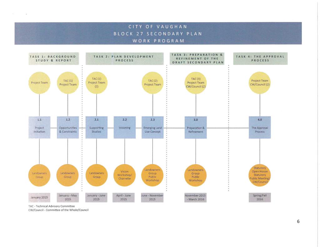
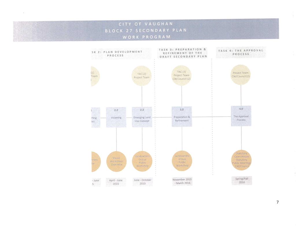
12 CITY OF VAUGHAN EXTRACT FROM COUNCIL MEETING MINUTES OF FEBRUARY 16, 2016 Item 4, CW(WS) Report No. 4 Page 12 f. Bus Tour Questions from the community focused on the timing of the projected Metrolinx Barrie GO Rail service improvements, and the timing of a decision and eventual construction of the potential GO Station at Kirby Road. There was a distinct need and desire expressed, to have a GO Station located within this community in the short term. Other comments/questions focused on concerns respecting noise/ traffic on Teston Road and in the general area, and on the planning process for this community. On Friday September 25, 2015, Policy Planning staff led a bus tour of two new communities in the GTA, the Mount Pleasant Village and mobility hub in Brampton, and the Bayview Wellington Centre in Aurora. The tour was organized to present members of the Landowners Group, the City s New Communities project team, and Council members with on the ground examples of communities that have been developed in accordance with the objectives and principles of new community areas. Brampton s Mount Pleasant Village and mobility hub was chosen as it is a good example of a new community built around a refurbished GO Station; and Aurora s Bayview Wellington Centre was selected because it reflects the densities, housing mix, land uses and design principles that will be expected in the Blocks 27 and 41 New Community Areas. At each of the sites, the tour group was greeted by municipal officials and staff, and provided with a presentation on their new community areas, followed by a guided walking tour. The excursion proved to be extremely informative, as was expressed to staff from all those participating in the event. Staff are available to brief any member(s) of Council that were unable to attend the tour. (4) Study Progress and Work Completed to Date The work program for the Block 27 Secondary Plan Study is divided into 4 phases. Each phase involves stakeholder engagement and the provision of deliverables. The study process has now progressed to Task 2.3 Emerging Land Use Concept (see Attachment 3). To-date significant background work has been completed including: i. Finalization of the detailed Work Plan and Consultation Strategy ii. Background review of existing conditions iii. An assessment of the various opportunities and constraints iv. A review of the environmental, archeological, commercial, open space, community service needs, municipal servicing, and sustainable community energy and practices objectives tailored to this future community v. Development of the draft land use concept vi. Preparation of supporting studies Also addressed through the detailed work plan are the various deliverables required throughout the study process. To-date the following reports have been finalized: i. Water and Wastewater Master Servicing Background Study, Amec Foster Wheeler, May 2015 ii. Land Budget and Housing Analysis for the Block 27 Secondary Plan Area, Hemson Consulting, May 2015 iii. Stage 1 Archeological Resource Assessment of the New Community of Block 27, AMEC Consulting, May 2015 iv. Cultural Heritage Resource Assessment, New Community Area Block 27, May 2015 v. Noise and Vibration Background Study, AMEC Foster Wheeler, May 2015 vi. Preliminary Background Report for Secondary Plan Study for New Community Area Block 27, Macaulay Shiomi Howson, June 2015 /13
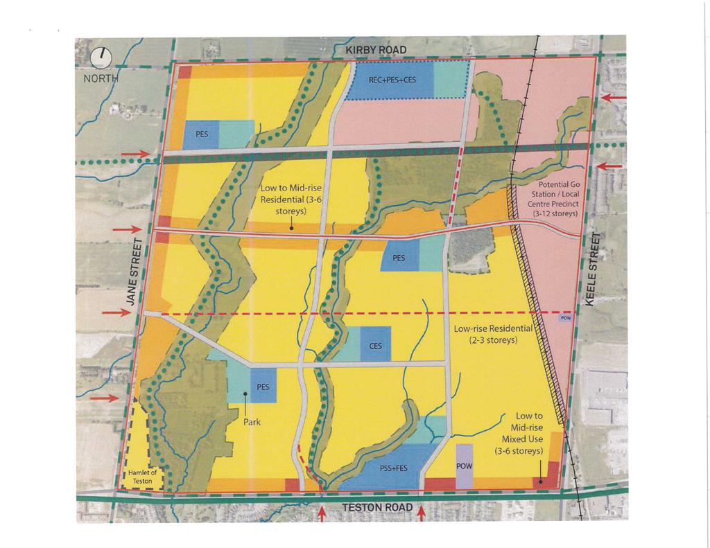
13 CITY OF VAUGHAN EXTRACT FROM COUNCIL MEETING MINUTES OF FEBRUARY 16, 2016 Item 4, CW(WS) Report No. 4 Page 13 At the time of preparation of this report, the following supporting studies/deliverables had been received in draft and are currently under review by Policy Planning and members of the TAC team. i. Commercial Needs Assessment, Tate Economic Research Inc., May 2015 ii. Natural Resource Assessment, New Community Area Block 27, April 2015 iii. Secondary Plan Study for New Community Area Block 27 Parks and Open Space & Community Facilities Report, Macaulay Shiomi Howson Ltd., May 2015 iv. New Community Area Block 27 City of Vaughan Environmental Report, May 2015 v. Vaughan Sustainability and Community Energy Framework, WSP Canada Inc., September 2015 (5) The Emerging Land Use Concept With the knowledge provided by the background studies and the information gathered at the public consultation, TAC, and LOG meetings, the Consulting team and City staff participated in a half day workshop on July 06, 2015, to develop a draft Emerging Land Use Concept. It is based on an approximate population of 26, 700 people at full build-out, approximately 9,000 units and an approximate commercial area of 52, 861 to 64, 567 m 2. The land budget numbers are based on the Draft Commercial Needs Assessment, conducted by Tate Economic Research, May The draft concept plan is described below. a. Community Structure The community is structured around the following elements: i. A mainly Low-rise residential community, with Low-Rise mixed-use along major collector roads and a potential GO Station/Local Centre Precinct within the northeastern portion of the block along the GO Rail line. ii. A variety of new neighbourhood parks proposed and linked to a network of recreational trails, including a potential east-west trail within the TransCanada Pipeline ROW. iii. Proposed institutional facilities, including 1 secondary school, 4 public elementary schools, 2 catholic elementary schools and 1 French elementary school. The potential for co-location will be explored in consultation with School Boards and City staff. iv. The provision of community facilities and commercial/mixed use nodes. v. An integrated street network connecting homes, schools, shops, transit stops (including the proposed GO Station Hub), and adjacent communities. vi. A connected parks and trails network that supports active and healthy living. vii. Natural areas that define neighbourhood boundaries while providing opportunities for placemaking, conservation and nature appreciation. viii. Infrastructure and utilities, including the TransCanada pipeline and proposed GO Station Hub. b. Population and Employment Density for Block 27 The proposed estimated population and employment density per hectare for Block 27 is in keeping with the York Region s minimum requirement of 70 people and jobs per hectare. /14
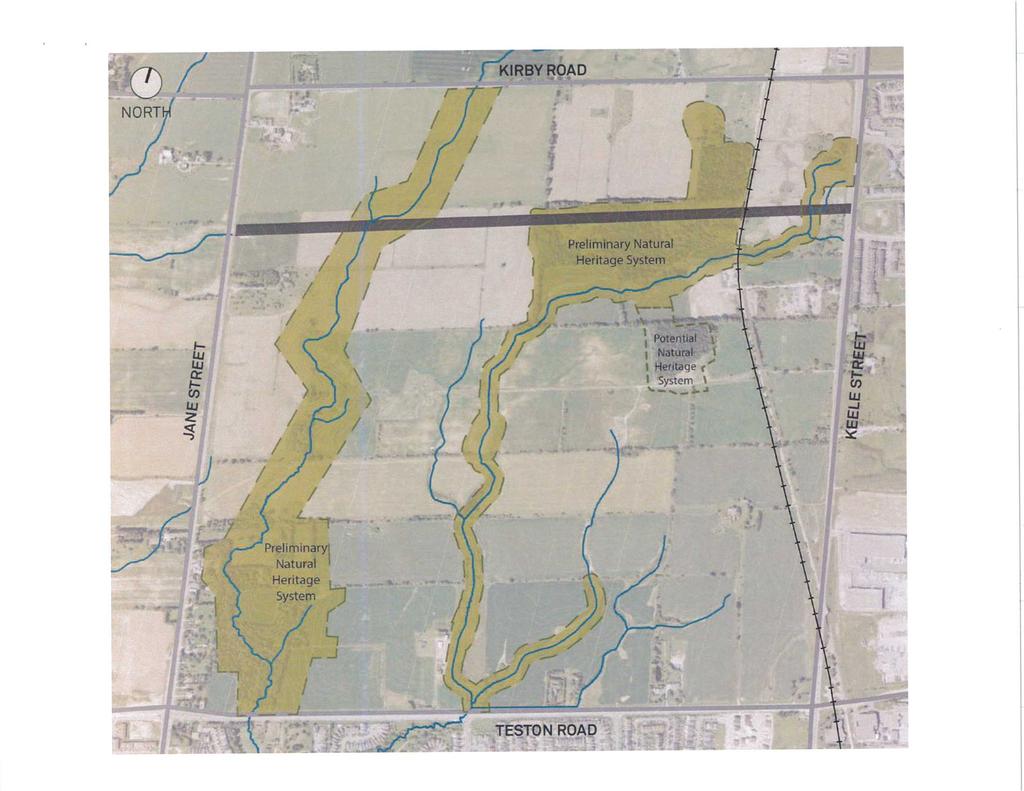
14 CITY OF VAUGHAN EXTRACT FROM COUNCIL MEETING MINUTES OF FEBRUARY 16, 2016 Item 4, CW(WS) Report No. 4 Page 14 Total Block 27 Developable Land Area 294 ha Total units People 19,158 26,691 Jobs 1, People + Jobs 20,693 28,826 People + Jobs per hectare Number of units per hectare GO Station / Local Centre Precinct Developable Land Area 54 ha Total units People Jobs 1, People + Jobs 5,785 8,570 People + Jobs per hectare Number of units per hectare Preliminary Comments c. Ministry of Natural Resources and Forestry (MNRF) MNRF have provided comments with respect to the environmental report and draft Subwatershed Study material (Natural Heritage Assessment Upper West Don Sub-watershed Study (Beacon Environmental, April 2015) which has been prepared to date, by the LOG s environmental Consultant. MNRF has requested that further field work be undertaken to better establish the boundaries of the NHN within Block 27 and discussions are underway to determine the extent of this additional work. Environmental field work requested by MNRF includes the following, much of which is appropriate at the Block Plan stage as part of an MESP submission. i. Delineation of species at Risk (SAR) habitat (Bobolink and Barn Swallow). ii. Delineation of Significant Wildlife Habitat. iii. Evaluation of woodlands for significance. iv. Survey of all tributaries within the study area for fish habitat in accordance with appropriate protocols. v. Assessment of the function of headwater drainage features and connected wetlands as they relate to downstream habitat to determine provision to direct or indirect fish habitat. vi. Wetland evaluation. vii. Identification of areas of groundwater recharge/discharge and affected features to identify features requiring protection and inclusion in the City s NHN. viii. Identification of additional east-west linkages to be incorporated into the NHN to accommodate wildlife passages between two natural heritage systems (Greenbelt NHS and the proposed Vaughan draft NHN). d. Preliminary Comments from TRCA The TRCA have also provided preliminary comments respecting the environmental report and draft Sub-watershed material which has been provided to date by the landowners Consultant. Their comments are summarized below. The City is reviewing the comments in relation to the Terms of Reference for the Sub-watershed Study for Block 27. /15
15 CITY OF VAUGHAN EXTRACT FROM COUNCIL MEETING MINUTES OF FEBRUARY 16, 2016 Item 4, CW(WS) Report No. 4 Page 15 i. Requirement for further assessment of potential impacts to natural features or functions related to future proposed development, and more information / direction for protection, mitigation or compensation. ii. Further assessment of fish sampling in intermittent streams earlier in the year (April/May) according to TRCA 2014 HDF Guideline. iii. Further information on location and quantification of existing wetland habitats. iv. Further description on the value of existing natural heritage features such as hedgerows and landscape connectivity beyond the block and sub-watershed. v. More description on the Local Natural Heritage System and what criteria have been used to define the system. vi. Description of the function of the wetlands concerning recharge should also be considered. vii. Recommends that further analysis be completed on the hydrogeologic component of the Sub-watershed Study (SWS) with respect to lack of integration of hydrogeologic data into the Natural Heritage Assessment report prepared by the SWS Consultants. viii. Requesting assurance that the ground water recharge and discharge functions are identified, mapped, and protected through the planning process, and that this should be completed at the Sub-watershed Study stage to inform future monitoring and wetland water balance work as part of the Block Plan stage. e. Preliminary Comments provided by Landowner Group (LOG) The Landowner Group has provided the following comments (summarized) respecting the proposed draft concept plan. i. The assessment on the status and inclusion of tributaries as Core Features within the Plan; ii. Completion of the local road network, including the design of the intersection at Cranston Park and Teston Road, and the status of the northerly proposed eastern north-south collector road; iii. Assessment of proposed road network crossings over Preliminary Natural Heritage Network designations; iv. Establishment of significant environmental features and compensation strategies; v. Establishment of permitted uses Local Centre Precinct designation and distribution of permitted land uses; vi. Finalization of number and locations of schools, parks and community centre; vii. Scoped Secondary Plan statistics as opposed to a range. This should include a more defined understanding of employment / residential population, number of units, unit type, density, etc.; viii. Review and reconsideration of location of retail / service commercial sites and stormwater management ponds; ix. More definitive understanding of crossings (underpass versus overpasses) along the GO Rail line; x. More definitive understanding of location of eastern north-south mid-block collector road and implications for pipeline; xi. Definitive understanding of and routing of trail systems including pedestrian connections to the railway. f. Issues to be addressed in further refining the Block 27 Land Use Concept Plan moving forward towards development of the draft Secondary Plan. i. The impact of the TransCanada pipeline ROW on the developable area within the block and impact on the proposed GO Station Hub area. /16
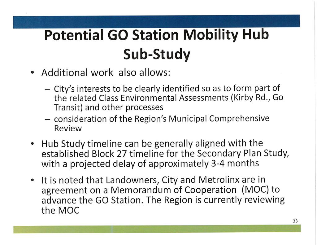
16 CITY OF VAUGHAN EXTRACT FROM COUNCIL MEETING MINUTES OF FEBRUARY 16, 2016 Item 4, CW(WS) Report No. 4 Page 16 ii. The detailed planning of the potential GO Station/Local Centre precinct in coordination with Metrolinx, the GO Station Review and the Regional Express Rail environmental assessment processes. iii. The interim phasing of the transit hub (before its potential development to a GO station) in coordination with YRT, TTC and Metrolinx. iv. The proposed co-location of the recreational facility with other public facilities, e.g. schools as a potential joint facility/community hub. v. The outcome of the GTA West Corridor EA including assessment of the proposed corridor alignment and interchange locations. vi. The proposed crossings of environmentally sensitive areas, and the defined limits of the NHN*. vii. Further examination of archeological assessment beyond those lands already examined; viii. Impacts of specific environmental areas on the draft concept and delineating the final natural heritage network to be reflected on the plan*: (1) Western Connectivity Corridor requires further examination of the feature extent. (2) Central Connectivity Corridor confirmation of the results of the Subwatershed Study are required to confirm groundwater and surface water flows, for wetlands in a few locations along the central riparian corridor. (3) Woodlots and wetlands evaluation of the significance of the existing woodlot adjacent to the proposed GO Station, north of the TCPL. (4) Several isolated wetlands in the eastern portion of the block not shown on the concept plan. vii. Any other issues which may arise through input received or discussion at this Committee of the Whole (Working Session) or from further consultation with the stakeholder groups and surrounding community. *City staff are currently in discussions with MNRF, TRCA and the Environmental Consultants to determine the scope of the additional environmental field work which will need to be done to inform the Secondary Plan process, as opposed to field work which can be completed at the Block Plan application stage. (6) Further Study in Response to Evolving Circumstances a. Rationale for GO Station Mobility Hub Sub-study Discussions with Metrolinx, the City s Transportation Consultant for the North Vaughan and New Communities Transportation Master Plan (NVNCTMP), the Ministry of Natural Resources and Forestry, TRCA, and City staff have identified a number of complexities associated with the proposed station and surrounding area. In order to advance the preparation of the policies and schedules to the Block 27 New Community Area Secondary Plan, it will be necessary to undertake more detailed work to address these matters. To accommodate a range of uses within the station precinct/mobility hub area, careful consideration will have be given as to how all of the uses are integrated into a compact, attractive, functional and sustainable centre. As such, it will be necessary to define a wider study area to accommodate the planned uses, and offer the opportunity to preserve and incorporate the important environmental elements and necessary infrastructure. This will allow for the planning to take place using the station as a starting point, extending outward to provide for a seamless transition to lesser intensity land uses at a radius of approximately 800 m. /17
17 CITY OF VAUGHAN EXTRACT FROM COUNCIL MEETING MINUTES OF FEBRUARY 16, 2016 Item 4, CW(WS) Report No. 4 Page 17 The mix of factors driving the need for greater certainty include the need to accommodate the following land uses and infrastructure within a relatively confined geography, and in consideration of the Natural Heritage Network, the existing GO Rail line; and the requirement to achieve internal road network connectivity. A more detailed Mobility Hub Sub-study will be needed to ensure that the resulting policies are based on a solid foundation, which is realistic and implementable through the available range of planning processes. The considerations include: The GO Rail Land Use: The GO Rail station platform (location, platform etc.); Passenger Pick Up and Drop Off; YRT-GO Bus Terminal; Commuter Parking. The Mobility Hub Land Uses: Accommodating the Metrolinx Mobility Hub Guidelines; Mix of Uses: Density, building height, residential, office, retail; parks, urban squares, public facilities, schools, community centres (community hubs); TCPL, Rail buffers, setbacks; Integration of land uses with GO Rail facilities. The Road Network: Identifying Arterial Road Accesses; Identifying the collector road crossing(s) of the GO Rail line; Ensuring internal road network continuity, sufficient to accommodate planned traffic; Ensuring that the Precinct/Mobility hub is seamlessly connected to the remaining part of the Block from all directions and to the arterial road system; Ensuring that road widths are consistent with the planned function. The Natural Heritage Network: Ensure that all relevant aspects of the NHN are identified and prioritized; All planning and infrastructure approval processes, including environmental assessments, prioritize the preservation of important resources and where necessary, provide for compensation where preservation would be inappropriate; That the NHN system contributes to the creation of a continuous open space, park, and stormwater management system, which will perform important ecosystem functions and provide an attractive community amenity. The proposed GO Rail Station/Mobility Hub area and the internal road network will be subject to a number of related approval processes in the form of Class Environmental Assessments. These processes are required for the following initiatives: Metrolinx/GO Regional Express Rail Twin Tracking and move to 2-way, all day service; The final station location and facilities (platform, passenger pick-up and drop-off, YRT/GO bus terminal, commuter parking). Metrolinx is now analyzing and prioritizing potential station sites across the system. The identified stations would be subject to the Environmental Assessment process; A Class Environmental Assessment for the Kirby Road arterial overpass, over the GO Rail line; /18
18 CITY OF VAUGHAN EXTRACT FROM COUNCIL MEETING MINUTES OF FEBRUARY 16, 2016 Item 4, CW(WS) Report No. 4 Page 18 A Class Environmental Assessment for an east-west collector overpass within Block 27, over the GO Rail line; A Class Environmental Assessment for various aspects of the internal road system, such as valley crossings. These processes will confirm the transportation infrastructure necessary to support major aspects of the Block 27 development, such as the station site and facilities, and the transit network. Given the number of contributing projects and the affected jurisdictions, these latter phases of the EA s for these projects will not be proceeding simultaneously. This presents challenges from a planning perspective. Some of these studies will be concurrent and will be able to build on and support the development of the Secondary Plan policies. However, others are beyond the timeframe of this process, especially the major infrastructure pieces identified above. This speaks to the need for the Secondary Plan to play a dual role. It would provide immediate land use guidance; and, it would also determine the requirements for the GO Station project and help to identify the City s preferred approach to the delivery of infrastructure in relation to the EA process. Integrating this approach as Secondary Plan policy will ensure that the City s interests are clearly stated for consideration by the EA s proponent. To ensure that the approach identified is sound and credible, sufficient study should take place to justify need. This justification and early planning should be done with the full participation of the expected proponent, in order to ensure that their interests are respected. Since many of these issues are related to the area of the GO Station/Mobility Hub, having a more detailed study to back the City position and to integrate all of the competing priorities, would be highly advantageous. As a result, staff are recommending preparation of a detailed Terms of Reference that is supported by all potential proponents including the City, Region, Metrolinx and Landowners. Another emerging issue will be the need to consider the results of the Region of York s Municipal Comprehensive Review (MCR), which is assigning population and employment growth to the City to the 2041 horizon. Block 28, to the north of this Secondary Plan area has been identified as an Urban Expansion Area within the 2036 timeframe. This entails that consideration be given to positioning the GO Station /Mobility Hub to best serve both Blocks 27 and 28. Including the Block 28 area in the urban envelope broadens the preliminary analysis that would need to be done. It might influence the location of the station, potentially making a connection to the north side of Kirby Road necessary. There would need to be greater consideration of north-south access into the station/hub and access to Kirby Road becomes a more important point of analysis. Block 28 may also affect facility size (e.g. passenger pick-up and drop-off, commuter parking supply and size of bus terminal may increase). The proposed focused study would need to consider immediate City needs as well as identify the city s preferences for future infrastructure projects. The interests of the affected external agencies and authorities would also be considered at this time. The level of complexity inherent in the mix of land uses, the number of non-concurrent approval processes and the proposed expansion of the urban boundary, support the need for a closer examination of the station area/mobility hub. A focused study of this area will support the policy development program for the Secondary Plan and ensure that the City s voice is heard throughout the various Environmental Assessment approvals. It will also help secure the form and function of the mobility hub as a defining feature in north Vaughan, while ensuring its integration into the Block 27 Secondary Plan area and the broader community. This study would be expected to inform the preparation of the implementing Block Plan application which will follow after the adoption of this plan. The original terms of reference for the Secondary Plan Study identified the need to investigate and develop policies to support a potential GO station mobility hub/local centre. /19
19 CITY OF VAUGHAN EXTRACT FROM COUNCIL MEETING MINUTES OF FEBRUARY 16, 2016 Item 4, CW(WS) Report No. 4 Page 19 However, given the complexity of the issues, it is now apparent that a more detailed level of investigation and study will be necessary. The scope of work for the more detailed Mobility Hub Study will include an examination of the finer grain details that will be necessary to make the station/hub function effectively. b. Timing It is expected that the additional work entailed by the focused GO Station mobility hub study will require approximately six months to complete, and will align to the extent possible, with the established time-lines and work program for the Secondary Plan Study. However, should the recommended hub sub-study be authorized by Council in February or March of 2016 pending Metrolinx study findings, the additional work would be initiated in March or April of Consequently, the Secondary Plan Study Work Plan could be off-set by 3-4 months as the outcomes of the sub-study will be required to assist in determining the Secondary Plan street network, land use designations, and associated policies. This could ultimately result in moving the projected completion of the Secondary Plan for Council consideration, from the fourth quarter of 2016 to the first quarter of All efforts will be made to accelerate the work to avoid any potential delays. (7) Status of Related Studies a. The North Vaughan and New Communities Transportation Master Plan (NVNCTMP) i. Introduction Since the release of the Notice of Commencement in July 2015, the project team for the North Vaughan and New Communities Transportation Master Plan (NVNCTMP) Study has been working closely with the project teams for the Blocks 27 and 41 Secondary Plans in developing the internal transportation networks in these Blocks. In addition, the NVNCTMP study team is considering the integration of the Block s internal transportation networks with the greater north Vaughan area. Draft conceptual plans were reviewed and comments and suggestions were provided. The NVNCTMP Study is being carried out in two Phases: Phase 1 will assess existing conditions, context and challenges; and Phase 2 will develop network plans and identify triggers for different infrastructure needs, phasing of projects and an action plan. The project team is proceeding into Phase 2 of the study and is beginning to identify the different transportation alternatives. During Phase 1 of this study, the Region and agencies were consulted through the Technical Advisory Committee Meeting held on August 6, Other key stakeholders such as landowners, ratepayers groups, First Nations and Metis Communities, and the Vaughan Bicycle Users group were consulted through the Stakeholder workshop held on August 19, In addition, the project team is working in close consultation with key stakeholders such as the Region, MTO and Metrolinx in coordinating key Regional infrastructure improvements. ii. Communication and Consultation - Notice of Public Information Centre 1 A key component of the Study is consultation with stakeholders, regulatory agencies and the general public. Key stakeholders and agencies are consulted through Stakeholder Workshops and the Technical Advisory Committee. Anyone from the /20
20 CITY OF VAUGHAN EXTRACT FROM COUNCIL MEETING MINUTES OF FEBRUARY 16, 2016 Item 4, CW(WS) Report No. 4 Page 20 public with an interest in this Study has the opportunity to get involved and provide input through Community Outreach Events, Community Workshops and Public Information Centres (PIC). Two PICs will be held during the Study to inform the process, present findings and receive public input. PIC 1 took place on Tuesday, October 13 th from 6:00 pm to 9:00 pm at Vaughan City Hall. A notice providing the time and location of this PIC was published in local newspapers and posted on the project website. PIC 1 introduced the study, provided information on the existing conditions and sought input on identifying opportunities, challenges and ideas for the future vision of transportation in the study area. The Project Team also reached out to the public by hosting a booth at the Binder Twine Festival and received good feedback on the vision/ concerns respecting the NVNCTMP study area. The team hosted another booth at the Woodbridge Fair from October 10 to October 12, 2015 to obtain broader input from the general public. A Community workshop will be held at City Hall in Winter 2015/2016 to provide the general public with an interactive opportunity to provide feedback on the key issues and ideas to address the issues such as potential transportation improvements for the NVNCTMP study area. iii. Next Steps The Project team will continue into Phase 2 of the study, which includes developing network plans and identifying alternative solutions, triggers for different infrastructure needs, phasing of projects and an action plan. The second Public Information Centre is planned for the Spring of A summary of the public discussion will be included in a feedback report, which will be posted on the project web site. b. The Metrolinx New Station Analysis Review Metrolinx is assessing a number of locations for potential new stations, to expand the regional express rail network. These specific sites are the result of a system-wide analysis and they include stations which are recognized in existing Regional and municipal Official Plans. Metrolinx has developed a process and methodology for assessing all locations, which recognizes the need to balance service frequency, expansion and cost. Review Process: Stage 1 (Complete) - Identified an initial list of 120+ sites using key site and network considerations. Stage 2 (Complete) - Focusing analysis: Analyzed site factors, service considerations and historical requests, to scope list to 50+ sites. Stage 3 (On-going) - Evaluating: Analyzing strategic, economic, technical/operational and cost/revenue considerations of 50+ sites. Stage 4 (Fall 2015) - Stakeholder and Public Engagement: Consultation, feedback and review of 50+ sites. Stage 5 (Winter 2015/16) - Moving to Shortlist: Following public engagement, scope sites for further analysis. /21
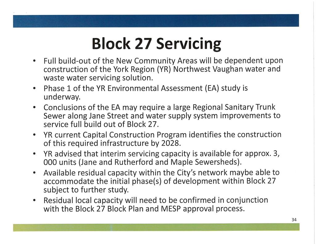
21 CITY OF VAUGHAN EXTRACT FROM COUNCIL MEETING MINUTES OF FEBRUARY 16, 2016 Item 4, CW(WS) Report No. 4 Page 21 Stage 6 (Winter 2015/16) - Further Analysis: A more detailed business case analysis will begin on shortlisted sites. Based on the results from further analysis, Metrolinx will make recommendations on new stations for consideration in the Spring of c. Block 27 Sub-watershed Study (West Don River) A sub-watershed study for the Don River is currently being undertaken by Cole Engineering and Beacon Environmental on behalf of the Landowners Group and will be peer reviewed by the City s consultant team. Work from the sub-watershed study has been initiated to support the preparation of the Block 27 New Community Area Secondary Plan. The study includes 6 components: A Hydrology Update and Stormwater Management Criteria Verification, A Regional Storm Assessment and Flood Impact Mitigation Strategy, An Erosion Assessment, Hydrogeology, Water Balance, and Natural Heritage Assessment/Ecology. To-date, the Project Team has coordinated and completed individual draft reports to address floodplain impacts, downstream erosion protection, hydrogeology, water balance, and the NHN. These reports have been reviewed by the City and TRCA staff. Comments have been provided to the SWS consulting team and discussions are ongoing to facilitate the preparation of the consolidated draft report by mid-november. The final SWS is expected to be completed in the first quarter of d. Servicing Requirements and Timing of Regional Infrastructure Improvements The full build-out of the New Community Areas will be dependent upon the construction of York Region s Northeast Vaughan water and wastewater servicing solution. The Environmental Assessment (EA) Study for these infrastructure improvements is currently underway. City staff is working closely with the Region to ensure the City s Water/Wastewater Master Plan requirements are fulfilled through completion of this Regional EA Study. It is anticipated that the conclusions of York Region s EA will require the construction of a large Regional Sanitary Trunk Sewer along Jane Street and water supply system improvements, in order to service the full build-out of Blocks 27 and 41. York Region s current Capital Construction Program identifies the construction of the required infrastructure improvements by In advance of the anticipated Regional infrastructure delivery date of 2028, York Region has advised that interim servicing capacity is available within the existing Regional network for approximately 10,000 people (3,000 residential units). Although this Regional system capacity will not fulfill the ultimate water and wastewater servicing needs of Blocks 27 and 41, initial phases of development within these areas may proceed based on available residual capacity within the City s network. However, residual local system capacity would be confirmed in conjunction with Block Plan/MESP approval. The City s on-going North Vaughan and New Communities Transportation Master Plan (TMP) Study is expected to be completed by the fourth quarter of The conclusions and recommendations of this study must also be considered to determine an appropriate Phase 1 development area for Blocks 27 and 41. /22
22 CITY OF VAUGHAN EXTRACT FROM COUNCIL MEETING MINUTES OF FEBRUARY 16, 2016 Item 4, CW(WS) Report No. 4 Page 22 As in the past, Landowners may approach York Region to explore alternate funding arrangements and/or contributions in order to advance the anticipated in-service date for the necessary Regional system improvements. (8) Next Steps in the New Community Area Block 27 Secondary Plan Study The Block 27 work plan identifies the next steps in the Secondary Plan Process below. However, staff note that the provided timelines are proposed targets and are very much dependent on the completion of the Mobility Hub Sub-study. Subject to authorization, finalize work plan for additional scope of work for a Mobility Hub Sub-study and initiate study - March 2016 Draft Secondary Plan - April 2016 Third Public Open House to present Draft Secondary Plan - June 2016 Fourth Open House - September 2016 Committee of the Whole Public Hearing (Statutory Meeting) - November 2016 Committee of the Whole to present the final draft of Secondary Plan - Winter 2017 Relationship to Term of Council Service Excellence Strategy Map ( ) This report is consistent with the Term of Council Service Excellence Strategy objectives to: Develop transit, cycling and pedestrian options to get around the City; Create and manage affordable housing options; and, Continue to cultivate an environmentally sustainable City. Regional Implications Regional staff are members of the Block 27 Technical Advisory Committee and are actively participating in the Secondary Plan process. The Draft Emerging Land Use Concept respects the relevant policies of the YROP, including the requirements for a minimum density of 70 people and jobs per hectare and a mix of land uses which promotes complete communities. Currently, the Region of York is undertaking a Municipal Comprehensive Review and Servicing Master Plan updates which will be reported on in the second quarter of The New Communities Secondary Plans may need to be updated based on these reports. Conclusions The New Community Area Block 27 Secondary Plan Study is proceeding according to the schedule set out in the approved work plan. As required in Phase 2.3 of the work program, the Draft Emerging Land Use Concept was developed and is currently under review. The Plan meets the policy requirements of the PPS 2014, the Growth Plan for the Greater Golden Horseshoe, the Greenbelt Plan, the York Regional Official Plan 2010, and the VOP The preliminary concept plan respects the development boundaries defined by the Greenbelt Plan and achieves the 70 people and jobs per hectare requirement established by the Region of York. The density and land use mix proposed for the GO Station Precinct/local centre are also consistent with the recommendations of the Metrolinx Mobility Hub Guidelines. In addition, the Plan achieves the land use mix required by both the YROP and the VOP 2010 to promote complete communities. City staff will be working closely with stakeholders and the Consulting team to address outstanding issues. Of particular importance will be the formulation of the land use, development and design policies for the GO Station/Local Centre Precinct. Given that the Secondary Plan and the Metrolinx studies have different time horizons, there will need to be close consultation with Metrolinx to ensure that the resulting policies are supportive of a station. /23
23 CITY OF VAUGHAN EXTRACT FROM COUNCIL MEETING MINUTES OF FEBRUARY 16, 2016 Item 4, CW(WS) Report No. 4 Page 23 To advance infrastructure studies in support of the GO Station and to address issues which have been raised through discussions with Metrolinx, the City s Transportation Consultant for the NVNCTMP, the environmental agencies and City staff, additional work is recommended. The additional study should also consider the implications of recent progress on the Regional Municipal Comprehensive Review respecting the projected urban boundary expansion for Block 28 within the 2036 timeframe. This may result in a 3-4 month off-set to the current Secondary Plan Study timelines, as explained in a previous section of this report. Moving forward, the concept plan will be further refined, with input from the additional GO Station Mobility Hub Sub-study, in the form of a draft Secondary Plan, including the land use policies, for presentation at a Committee of Council meeting later in Attachments 1. Context Location Map 2. Block 27 Location Map 3. New Community Area Block 27 Secondary Plan Study Work Program 4. Draft Land Use Concept Plan for Block Block 27 Gross Density Calculation Report prepared by: Melissa Rossi, Senior Planner, ext.8320 Anna Sicilia, Project Manager, New Community Areas, ext.8063 (A copy of the attachments referred to in the foregoing have been forwarded to each Member of Council and a copy thereof is also on file in the office of the City Clerk.) Regional Councillor Di Biase declared an interest with respect to this matter as his children own land in Block 27 given to them by their maternal Grandfather, as well, he is a named defendant in a lawsuit by Di Poce Management who own lands in Block 27 and did not take part in the discussion or vote on the matter. Regional Councillor Rosati declared an interest with respect to this matter as he is a named defendant in a lawsuit by Di Poce Management who own lands in Block 27 and did not take part in the discussion or vote on the matter.
24
25
26
27
28
29
30
31
32

33
34
35
36
37
38
39
40
41
42
43
44
45
46
47
48
49
50
51
52
53
54
55
56
57
58
59
60
61
62
63
64 COMMITTEE OF THE WHOLE (WORKING SESSION) JANUARY 18, 2016 NEW COMMUNITY AREA BLOCK 27 SECONDARY PLAN STUDY STATUS UPDATE REPORT AND DIRECTION TO INCREASE SCOPE OF WORK FILE: WARD 1, VICINITY OF JANE STREET, KIRBY ROAD, KEELE STREET AND TESTON ROAD Recommendation The Deputy City Manager, Planning & Growth Management and the Director of Policy Planning & Environmental Sustainability, in consultation with the Director of Development Engineering & Infrastructure Planning recommend: 1. THAT this status report and accompanying presentation on the progress of the Secondary Plan Study for the Block 27 New Community Area be received for information purposes; 2. THAT staff be directed to work with the Landowners Group, York Region and Metrolinx to prepare a Terms of Reference for a Mobility Hub Study that includes the conceptual design of a proposed GO Station in Block 27 and Kirby Road upgrades adjacent to Blocks 27 and 28, to inform future Environmental Assessment requirements associated with the GO Station, Kirby Road, and the ongoing Metrolinx Regional Express Rail Study. Contribution to Sustainability The Block 27 Secondary Plan must be consistent with the policies of the Region of York Official Plan, Places to Grow: the Provincial Growth Plan for the Greater Golden Horseshoe, The Big Move Regional Transportation Plan, the Vaughan Official Plan 2010; and, with Green Directions Vaughan, the Community Sustainability and Environmental Master Plan respecting sustainable development and the creation of complete communities. Economic Impact The funding for the Block 27 Secondary Plan study was approved in the 2013 Capital Budget as Project PL with a budget of $515,000. Staff are recommending that a Terms of Reference for a more detailed study of the GO Station mobility hub, and Kirby Road west of Keele Street and surrounding area (as shown on Attachment 4), to ensure the City and Region can continue to respond to the findings of the Metrolinx Regional Express Rail initiative. Staff anticipates that the City portion of the additional work will be funded from the City-Wide Development Charges (CWDC)-Management Studies (90%), and Professional Fees (10%). The landowners groups in Block 27 and Block 28 would be expected to provide support including technical input to inform this effort. The financial impact will be determined in more detail once the scope of work is finalized. Communications Plan A courtesy non-statutory meeting notice was sent via on January 4, 2016 to the Block 27 Landowners and those previously requesting notification and updates on the progress of the Block 27 Secondary Plan Study. The notice was also advertised on the Policy Planning and Environmental Sustainability departmental webpage for the New Community Areas and on the Vaughan City Page On-line.
65 Purpose To provide Council and interested stakeholders with an update on the progress of the Block 27 Secondary Plan; and, to obtain direction to prepare the terms of reference for the detailed study of the GO Station and Kirby Road upgrades, that will inform Environmental Assessment requirements associated with the Station, Kirby Road and the ongoing Metrolinx Regional Express Rail initiative. Background - Analysis and Options Executive Summary The Block 27 Secondary Plan Study is proceeding on schedule. This report outlines the Draft Emerging Land Use Concept and the proposed work program to further refine the Plan prior to approval. The report discusses and recommends an additional study opportunity to advance Council s objective of achieving a Go Train Station at Kirby Road. This more detailed study will inform and better position the City and Stakeholders to respond to the Regional Express Rail initiative. This report is structured into sections which provide the following information: (1) A description of the study area and land use context; (2) A description of the Provincial, Regional and municipal policy framework guiding the development of the Secondary Plan; (3) The public and agency consultation process to date; (4) Study progress and work completed to date; (5) The draft Land Use Concept and related issues; (6) Rationale for detailed study of mobility hub area in response to evolving circumstances; (7) Status of the supporting studies; (8) Next Steps in the study process; and (9) Conclusion leading to the report s recommendation. (1) Location and Context The Block 27 area, as shown on Attachment 2, is bounded by Teston Road to the south, Keele Street to the east, Kirby Road to the north and Jane Street to the west. The subject lands are surrounded by the following uses: North - Kirby Road; Greenbelt; Agricultural South - Teston Road; existing Low-Rise Residential East - Keele Street; existing residential and employment lands; proposed north Maple Regional Park West - Jane Street; approved Highway 400 North Employment Lands The Block 27 lands have a total area of approximately 400 ha and are primarily rural in nature, with some existing residential and institutional uses. A portion of the Greenbelt traverses the block north to south, including a main tributary of the West Don River Sub-watershed. Also located within the Block 27 boundary is the TransCanada Pipeline which runs east-west in the northern portion of Block 27 as shown on Attachment 2. In addition, the Barrie GO Rail line runs north-south along the eastern portion of the Block, with the proposed station site being located in the vicinity of Kirby Road. (2) Policy Context The York Regional Official Plan (YROP) and the Vaughan Official Plan (VOP 2010) were developed under the broader policy framework provided by the Provincial Policy Statement, the
66 Growth Plan for the Greater Golden Horseshoe, and the Greenbelt Plan. The policies arising from the Secondary Plan Study for New Community Area Block 27, must be consistent with each of these Provincial, Regional and municipal policy frameworks. The following policies provide high level guidance on the desired outcome. a. The Provincial Policy Statement 2014 (PPS 2014) The Provincial Policy Statement 2014 (PPS 2014) provides policy direction on land use planning to promote strong communities, a strong economy, and a clean and healthy environment. Part IV, Vision of Ontario s Land Use Planning System of the PPS 2014 further states: i. Land use must be carefully managed to accommodate appropriate development to meet the full range of current and future needs, while achieving efficient development patterns (S. 1.0); ii. Efficient development patterns optimize the use of land, resources and public investment in infrastructure and public service facilities (Part IV) ; iii. Efficient use of existing and planned infrastructure, including the use of transportation demand strategies where feasible (S ); maintain or improve the connectivity within and among transportation systems and modes, where possible (S ), encourage and support a land use pattern, density and mix of uses which minimizes length and number of vehicle trips, and supports the current and future use of transit and active transportation (S ). b. Places to Grow: The Growth Plan For the Greater Golden Horseshoe (GGH) The Growth Plan for the Greater Golden Horseshoe (GGH) promotes strong, prosperous communities by managing growth to the year It also builds on other provincial initiatives such as the Greenbelt Plan and the PPS While emphasizing opportunities to enhance and intensify existing communities, the Growth Plan provides guidance for designated Greenfield Areas, such as Block 27, which have been identified for future residential growth. Under Section of the GGH Plan, new community areas are intended to be welldesigned, offer transportation choices, and accommodate people at all stages of life. They are expected to provide a mix of housing types along with easy access to stores and services, to meet daily needs. c. Greenbelt Plan The Greenbelt Plan designates a portion of the Block 27 area as Protected Countryside, which includes Agricultural and Natural Systems, together with settlement areas which are subject to the policy of Section 4.0 of the Plan. Hamlets as identified in municipal official plans continue to be governed by municipal official plans and related programs and are not subject to the policies of the Greenbelt Plan except for external connections (s.3.4.3). The Greenbelt Plan designations and policies are reflected in the YROP and the VOP d. The Big Move, 2008 (Metrolinx) Regional Transportation Plan In November 2008, Metrolinx adopted a Regional Transportation Plan, entitled The Big Move: Transforming Transportation in the Greater Toronto and Hamilton Area to tackle gridlock across the Greater Toronto and Hamilton Area (GTAH). The Plan provides for the development of an integrated transit and transportation system to better move people and goods.
67 The Regional Transportation Plan sets out a 25 year vision. It is guided by a set of 13 goals and related objectives which are designed to achieve a more efficient and sustainable transportation system for the GTAH. It is noted that many of the objectives will help to achieve more than one goal. The goals and objectives are intended to provide guidance for decision-making and planning at all levels, including the provision of Transit Oriented Development, to support system development. In order to fulfill this mandate, The Big Move has established a number of strategies. Schedule 1 15 Year Plan for the Regional Rapid Transit and Highway Network outlines a plan to build a comprehensive regional rapid transit network that operates seamlessly across the region. The 15 year plan for regional rapid transit identifies all day, two-way Regional Rail service through Block 27. The policies indicate that this rapid transit network must be incorporated in all municipal Official Plans and as noted above, this is currently reflected in the YROP and the VOP Both Official Plans also identify the potential for a GO Rail Station in the vicinity of Kirby Road and Keele Street. Another strategy established in The Big Move is to build communities that are pedestrian, cycling and transit supportive, recognizing that people who live in higher density neighbourhoods with services nearby are more likely to walk, cycle or take transit. The Big Move acknowledges that the interface between urban form and transportation is particularly important around transit stations, therefore growth and development should be focused around major transit stations to allow more people to live near transit and to make more destinations accessible by transit. An intent of the Big Move is to create a system of connected mobility hubs at key intersections in the regional rapid transit network. The Plan identifies a Mobility Hub as a major transit station area, as defined in the Growth Plan for the Greater Golden Horseshoe. It is a place of connectivity between regional rapid transit services, and also a place where different modes of transportation, from walking to high-speed rail, come together seamlessly. It has, or is planned to have an attractive, intensive concentration of employment, living, shopping and amenities around a major transit station. To be identified as a mobility hub, a major transit station area must be located at the interchange of two or more current or planned regional rapid transit lines and be forecast to have a combination of 4,500 or more people boarding and alighting in the morning peak period in In addition, a mobility hub is generally forecast to achieve or have the potential to achieve a minimum density of approximately 10,000 people and jobs within an 800 metre radius. Metrolinx Mobility Hub Guidelines (September 2011) As part of the implementation of the Big Move, Metrolinx has prepared Mobility Hub Guidelines to communicate the objectives, characteristics and role of Hubs and provide guidance on the development of Mobility Hubs. The Guidelines identify the following objectives: Seamless Mobility: o Seamless integration of modes at the rapid transit station o Safe and efficient movement of people with high levels of pedestrian priority o A well-designed transit station for a high quality urban experience Placemaking: o Strategic parking management o A vibrant mixed-use environment with higher land use intensity o An attractive public realm
68 Successful Implementation: o A minimized ecological footprint o Flexible planning to accommodate growth and change o Effective partnerships and incentives for increased public and private investment The mobility hubs identified by the Big Move are all a type of major transit station area. The Growth Plan requires that municipalities plan these identified areas with densities that support the existing and planned rapid transit infrastructure. The Mobility Hub Guidelines provide suggested density thresholds for the different mobility hub typologies. Table ii.3 of the Mobility Hub Guidelines provides Hub typologies. The Mobility Hub Guidelines indicate the following characteristics for Regional Rail mobility hubs: Expansion, as envisioned in The Big Move, includes improving service from peakdirection and period rail service to all-day, two-way service. Land use density and mode share targets should reflect the existing and planned service levels for regional rail corridors. In most cases, Regional rail attracts the majority of its riders from a large catchment area beyond the mobility hub. As a result, ridership is less sensitive to the densities within the hub. Suggested transit supportive densities (includes residents and jobs combined per hectare, within a mobility hub) ranging between persons. Suggested transit mode share (trips originating within mobility hub) ranging between 10 25%. While currently lacking the interconnection to a second Regional rapid transit service, transit service on Keele Street is already available. Therefore, a Block 27 GO Rail Station can be designed to meet many of the mobility hub guidelines. This opportunity is being investigated through the Secondary Plan Study. This study is occurring concurrently with the Metrolinx Regional Express Rail Environmental Assessment (electrification, 2 way-all day service and double tracking) and an assessment of potential station sites system wide. The Kirby Road station has been identified as a site for further study. The City, Region and landowners are working with Metrolinx to coordinate the Environmental Assessment Act approval and Planning Act approval processes. The Block 27 Secondary Plan is being prepared to accommodate a Kirby Station, including meeting the mobility hub guidelines for a GO Rail Station. e. York Region Official Plan (YROP) The New Community Area policies of the YROP focus on creating sustainable communities with a pedestrian friendly, transit supportive transportation system that will reduce reliance on automobiles. Section 1.2 Towards A Sustainable Region, establishes a framework for achieving sustainability and rethinking the way communities are designed, serviced and supported. Section 5.6 titled Building Complete, Vibrant Communities references the new community areas as places where people interact, learn, work, play and reside. Excellence in community design is essential to creating a physical place where people have the opportunities and choices required to lead rewarding lives. Furthermore, with respect to the New Community Areas, it is the policy of Regional Council that,
69 5.6.1.local municipalities, in consultation with York Region, prepare comprehensive Secondary Plans for New Community Areas that meet or exceed the policies of this section of this Plan. The Secondary Plan preparation should include an innovative approach that involves a multidisciplinary team assembled by the local municipality in order to ensure an integrated and sustainable approach to the planning, design and approval of the Secondary Plan. f. The York Region New Community Guidelines (YRNCG) The YRNCG were created to assist local municipalities and the development industry in successfully implementing the YROP (2010) New Community Areas (section 5.6) and Sustainable Buildings (section 5.2) policies. As such the Guidelines address the York Region Official Plan policy directives by providing checklists and more specific requirements for each of the following general policy objectives. i. To build complete communities through a comprehensive and integrated Secondary Plan process that recognizes, conserves and promotes cultural heritage resources, supports sustainable built form and ensures new community areas provide housing choices for all residents and workers. New Community Areas are to meet or exceed a minimum density of 20 residential units per hectare and a minimum density of 70 residents and jobs per hectare in the developable area. ii. Energy efficiency through sustainable building construction, solar design strategy, and on-site renewable or alternative energy systems. iii. To create an interconnected mobility system in new community areas that emphasizes pedestrian, cycling and transit as preferred modes of transportation. iv. To ensure Greenlands System Plans are prepared in support of Secondary Plans for new community areas that protect key natural heritage and hydrologic features in an urban environment, improve the ecological function, connectivity and diversity of the Greenlands System and ensure ecological gains. v. To manage resources by encouraging the diversion of construction and demolition waste implementing three-stream waste collection capabilities, encouraging increased use of environmentally preferable and locally-sourced materials, and through public education. vi. To pursue excellence in community design. g. Vaughan Official Plan 2010 (VOP2010) Vaughan Official Plan 2010 (VOP 2010) designates Blocks 27 and 41 as New Community Areas. Furthermore, Schedule 14A Areas Subject to Secondary Plans identifies the Block 27 and 41 New Community Areas as Required Secondary Plan Areas. Consistent with the YROP, the New Community Areas are part of Vaughan s Urban Area and are intended to develop as complete communities with residential and local populationserving retail and commercial uses. The Block 27 and 41 New Community Areas will provide most of the City s new low-rise housing stock, as well as the supporting commercial uses for the Blocks, and community facilities such as schools, parks, community centres and libraries. The Secondary Plans for the new communities should set the policy framework for the development of complete communities with a unique sense of place and high quality design.
70 VOP 2010 further provides guidance on the preparation and content of the New Community Areas Secondary Plans. Policies outlined in Section New Community Areas list specific objectives and describe the desired character of development for the New Community Areas. (3) The Study Consultation Process to Date The Block 27 Secondary Plan Study is proceeding with the benefit of an extensive public and stakeholder consultation process. The consultation strategy provides two main methods of advertising events/milestones related to the Block 27 Secondary Plan process. A social media campaign, including the placement of meeting notices on Vaughan Online, Twitter and Facebook (for one-way communication); the creation of a webpage devoted to the New Community Areas and a friendly Uniform Resource Locator (URL). The second method employed includes a print campaign which involves the mailing of meeting notices to stakeholders and the surrounding community. It is also noted that a notice of study commencement was published in the Vaughan Citizen and Liberal on March 12, Key participants in the consultation process include City Council, the Block 27 Technical Advisory Committee (TAC), the Block 27 Landowners Group (LOG), the First Nations and Metis Communities, and residents/landowners in the surrounding communities. a. Council Engagement Memoranda to Council: Two memoranda to the Mayor and Members of Council respecting the New Community Areas were provided to inform Council of the initiation (February 12, 2015) and progress (July 20, 2015) of the Secondary Plan Studies for Blocks 27 and 41. The memoranda reported the study progress, provided a synopsis of the consultant s Preliminary Background Report, and introduced a draft vision statement and development principles for the future community. The memoranda also provided updates on the status of related studies, including Sub-watershed Studies and The North Vaughan and New Communities Transportation Master Plan (NVNCTMP). b. Block 27 Technical Advisory Committee (TAC) The Block 27 Secondary Plan Technical Advisory Committee (TAC) is comprised of internal City departmental staff and external agencies. City representation on the TAC includes representatives from the following departments: Development Engineering and Infrastructure Planning, Parks Development, Recreation and Culture, Development Planning, Vaughan Libraries, and Policy Planning and Environmental Sustainability. Representation from external agencies includes staff from York Region, the Toronto and Region Conservation Authority (TRCA), the York Region District and York Catholic School Boards, the Consiel Scolaire Viamonde, the Ministry of Natural Resources and Forestry, the telecommunications industry, TransCanada Pipeline, Metrolinx, as well as the Consultant for the Block 27 Subwatershed Study. The Block 27 Secondary Plan Study work plan includes 7 TAC meetings. To-date a total of two TAC meetings have been held, along with a number of focused meetings with individual agencies. i. April 22, 2015 The initial meeting served as an introduction to the City project staff, lead consultants and work program going forward. This meeting provided TAC with an update on the status of the Secondary Plan, and also included presentations respecting transportation issues, the Natural Heritage Network (NHN), the Sustainability Matrix, the Sub-watershed Study, and a status update on the Metrolinx GO Station.
71 May 27, 2015 This meeting provided an overview of the visioning workshop and presentation of supporting technical background studies. Meetings with Metrolinx: i. April 2, 2015 Kirby GO Station Mobility Hub Workshop workshop served as an information sharing session with the City, Region and Metrolinx staff to obtain an understanding of mandates / objectives and criteria for the Metrolinx New Station Review. ii. September 28, 2015 Staff meeting with Metrolinx. Presentation of concept plan and discussion on Metrolinx criteria used in station analysis. iii. October 19, 2015 Block 27 Kirby GO Station staff meeting with Block 27 Landowners Group, Metrolinx, Regional and City staff, and City consultants to discuss the Block 27 Secondary Plan status, and to present the rationale for the proposed draft concept Plan including siting of the potential GO Station. Meeting with School Boards: i. August 24, 2015 Meeting with School Board staff to introduce the draft concept plan and to discuss the possibility of a Community Hub in Block 27. c. Block 27 Landowners Group (LOG) The Landowners Group consists of 8 participating landowners. The work plan for the study includes 8 meetings with the LOG, 5 of which have already taken place. A brief summary of meetings to date is provided as follows: i. Meeting #1 - February 05, 2015: The initial meeting served as an introduction to the City Consulting Team and work plan for the Block 27New Community Area Secondary Plan Study. ii. Meeting #2- April 22, 2015: This meeting provided Landowners with an update on the status of the Secondary Plan, and also included presentations to the landowners respecting transportation issues, the NHN, the Sustainability Matrix, the Subwatershed Study, and a status update on the Metrolinx GO Station. iii. Meeting #3- June 1, 2015: The third LOG meeting included a presentation by the lead Consultant on the results of the First Public Open House - Visioning Summit and a review of the opportunities and constraints identified by the project team. This was followed by a presentation by City staff on the North Vaughan and New Communities Transportation Master Plan (NVNCMTP), and a status update on Block 27 background studies and supporting analyses. iv. Meeting #4 - July 28, 2015: This fourth special meeting with LOG focused on the technical analysis conducted in the development of the draft emerging land use concept. Discussions focused on data and land use statistics used for the Block 27 emerging land use concept, land use budget objectives, housing mix objectives, and the proposed New Kirby GO Station precinct objectives. v. Meeting #5 - August 24, 2015: This meeting focused on the status of the Secondary Plan, review of the Emerging Land Use Concept Plan and key structural elements such as the NHN study, parks, grid-like pattern, school, and stormwater management ponds.
72 d. Consultation with First Nations and Metis Communities The consultation process for the Block 27 Secondary Plan Study also included notification of the required First Nation and Metis Communities. On March 26, 2015 the City initiated consultation with an introductory letter to all First Nation and Metis communities that have an interest in the City of Vaughan. Of the 13 communities requiring notification, 3 have responded that they would like to receive information on the study progress as it becomes available. To date the 3 communities have been provided with the following documentation: the Preliminary Background Report for Block 27, prepared by Macaulay Shiomi Howson Ltd; dated June 2015; the Cultural Heritage Resource Assessment for Block 27, prepared by ASI Archaeological & Cultural Heritage Services, dated May 2015; and, the Stage 1 Archaeological Resource Assessment for Block 27, prepared by ASI Archaeological & Cultural Heritage Services, dated July In addition, at the request of the Mississaugas of the New Credit First Nation Community, on October 27, 2015, City staff attended a meeting with their representatives to discuss the New Community Areas of Block 27 and 41 as well as the North Vaughan and New Communities Transportation Master Plan. e. Public Open House To date, two public consultation meetings have been held with the Block 27 study area landowners and the landowners in the surrounding community. i. First Public Open House - Visioning Summit: On April 29, 2015 a notice was mailed to all property owners located within 700m of the Block 27 area boundary, as well as to property owners within Block 27, and to all Registered Ratepayer organizations east of Highway 400. The notification provided details respecting the First Public Open House Visioning Summit hosted by the City and scheduled for May 13, Approximately 100 people were in attendance for the presentation and workshop. The City s consultant, Macaulay Shiomi Howson presented panels that provided an overview of the study process, as well as development and land use type precedent images which participants were asked to label as being desirable or not desirable for the Block 27 community. MSH provided a presentation giving an overview of the planning process, introducing the team, study objectives, and opportunities and constraints. The second half of the meeting consisted of a workshop exercise where participants were asked to work in groups of 8 10 people. The groups were given a series of visioning questions and were also asked to sketch out ideas regarding the future growth and development of Block 27. The participants expressed a preference for small to medium scale buildings for residential, retail, and commercial development, and support for a mix of uses with a focus on community facilities such as schools and places of worship. Residents expressed concerns respecting traffic and noise along Teston Road and Kirby Road. Support was voiced for active transportation modes such as trails and multi-use paths; and, greater public transportation options, including a GO station and transportation hub with increased parking options. They expressed a desire for additional open space including grand parks, nature trails, social gathering spaces, active outdoor spaces, community gardens; and, preservation of natural features. The summit participants also favoured sustainable design features such as bio-
73 swales, and permeable surfaces. It is noted that the Visioning Summit planning exercise was also completed by the Ward 1 Residents Committee and their responses have been integrated into the general results of the summit workshop. The results from the workshop included the development of a draft vision statement for Block 27 and draft development principles as follows: (1) Draft Vision Statement: Block 27 will be a complete community that prioritizes people, sustainability and livability with high quality urban design. It will feature a range of low to mid-rise buildings that blend a variety of residential, commercial, and institutional uses such as schools and community facilities. It will also contain a transit hub. Building upon the areas abundant natural heritage features; a variety of parks and open spaces will provide residents with areas for leisure and recreation. (2) Draft Development Principles An intimate community character will be encouraged through the use of low to mid-rise building form and scale. New development will blend a combination of residential, commercial, and institutional uses to create a walkable, sustainable and amenity rich community. Streetscape design will support a variety of uses and conditions, including automobile, cycling, and pedestrian activity. Block configuration will follow a modified grid pattern, encouraging compact and sustainable development. Seamless integration of alternative modes of transportation will expand local and regional transportation options and access, while also encouraging environmental sustainability. Community facilities such as schools, places of worship, and community centres will be promoted and situated in a way that creates a social and cultural hub for the community. A hierarchy of parks and open spaces with a range of programming opportunities will provide the community with a variety of rich and vibrant urban and natural spaces for recreation. Preservation of natural heritage features will provide an opportunity for views and access to nature. Sustainability will be encouraged through the conscientious selection of building materials and finishes, surface treatments, blue-green infrastructure, and other green features. ii. Second Public Open House Review of the Draft Emerging Land Use Concept: A second Public Open House was held on November 25, The notice for the Second Public Open House was mailed out to all Block 27 land owners, and to property owners within 200m of the boundary of the subject lands, and to all Registered Ratepayers organizations on the east side of Highway 400. In addition, community members who had requested notification as a result of the polling conducted for the first public consultation meeting were also sent notice. The public meeting was attended by approximately 45 people. The meeting began with a thirty minute free-style viewing of several display boards reflecting important aspects of the study material and draft emerging concept plan. The participants were provided an opportunity to comment on the work completed to date by placing
74 f. Bus Tour comment notes directly on the display boards. The comment note session was followed by a presentation on the status of the Secondary Plan by the City s Consultant, followed by a question and answer period. Questions from the community focused on the timing of the projected Metrolinx Barrie GO Rail service improvements, and the timing of a decision and eventual construction of the potential GO Station at Kirby Road. There was a distinct need and desire expressed, to have a GO Station located within this community in the short term. Other comments/questions focused on concerns respecting noise/ traffic on Teston Road and in the general area, and on the planning process for this community. On Friday September 25, 2015, Policy Planning staff led a bus tour of two new communities in the GTA, the Mount Pleasant Village and mobility hub in Brampton, and the Bayview Wellington Centre in Aurora. The tour was organized to present members of the Landowners Group, the City s New Communities project team, and Council members with on the ground examples of communities that have been developed in accordance with the objectives and principles of new community areas. Brampton s Mount Pleasant Village and mobility hub was chosen as it is a good example of a new community built around a refurbished GO Station; and Aurora s Bayview Wellington Centre was selected because it reflects the densities, housing mix, land uses and design principles that will be expected in the Blocks 27 and 41 New Community Areas. At each of the sites, the tour group was greeted by municipal officials and staff, and provided with a presentation on their new community areas, followed by a guided walking tour. The excursion proved to be extremely informative, as was expressed to staff from all those participating in the event. Staff are available to brief any member(s) of Council that were unable to attend the tour. (4) Study Progress and Work Completed to Date The work program for the Block 27 Secondary Plan Study is divided into 4 phases. Each phase involves stakeholder engagement and the provision of deliverables. The study process has now progressed to Task 2.3 Emerging Land Use Concept (see Attachment 3). To-date significant background work has been completed including: i. Finalization of the detailed Work Plan and Consultation Strategy ii. Background review of existing conditions iii. An assessment of the various opportunities and constraints iv. A review of the environmental, archeological, commercial, open space, community service needs, municipal servicing, and sustainable community energy and practices objectives tailored to this future community v. Development of the draft land use concept vi. Preparation of supporting studies Also addressed through the detailed work plan are the various deliverables required throughout the study process. To-date the following reports have been finalized: i. Water and Wastewater Master Servicing Background Study, Amec Foster Wheeler, May 2015 ii. Land Budget and Housing Analysis for the Block 27 Secondary Plan Area, Hemson Consulting, May 2015 iii. Stage 1 Archeological Resource Assessment of the New Community of Block 27, AMEC Consulting, May 2015 iv. Cultural Heritage Resource Assessment, New Community Area Block 27, May 2015
75 v. Noise and Vibration Background Study, AMEC Foster Wheeler, May 2015 vi. Preliminary Background Report for Secondary Plan Study for New Community Area Block 27, Macaulay Shiomi Howson, June 2015 At the time of preparation of this report, the following supporting studies/deliverables had been received in draft and are currently under review by Policy Planning and members of the TAC team. i. Commercial Needs Assessment, Tate Economic Research Inc., May 2015 ii. Natural Resource Assessment, New Community Area Block 27, April 2015 iii. Secondary Plan Study for New Community Area Block 27 Parks and Open Space & Community Facilities Report, Macaulay Shiomi Howson Ltd., May 2015 iv. New Community Area Block 27 City of Vaughan Environmental Report, May 2015 v. Vaughan Sustainability and Community Energy Framework, WSP Canada Inc., September 2015 (5) The Emerging Land Use Concept With the knowledge provided by the background studies and the information gathered at the public consultation, TAC, and LOG meetings, the Consulting team and City staff participated in a half day workshop on July 06, 2015, to develop a draft Emerging Land Use Concept. It is based on an approximate population of 26, 700 people at full build-out, approximately 9,000 units and an approximate commercial area of 52, 861 to 64, 567 m 2. The land budget numbers are based on the Draft Commercial Needs Assessment, conducted by Tate Economic Research, May The draft concept plan is described below. a. Community Structure The community is structured around the following elements: i. A mainly Low-rise residential community, with Low-Rise mixed-use along major collector roads and a potential GO Station/Local Centre Precinct within the northeastern portion of the block along the GO Rail line. ii. A variety of new neighbourhood parks proposed and linked to a network of recreational trails, including a potential east-west trail within the TransCanada Pipeline ROW. iii. Proposed institutional facilities, including 1 secondary school, 4 public elementary schools, 2 catholic elementary schools and 1 French elementary school. The potential for co-location will be explored in consultation with School Boards and City staff. iv. The provision of community facilities and commercial/mixed use nodes. v. An integrated street network connecting homes, schools, shops, transit stops (including the proposed GO Station Hub), and adjacent communities. vi. A connected parks and trails network that supports active and healthy living. vii. Natural areas that define neighbourhood boundaries while providing opportunities for placemaking, conservation and nature appreciation. viii. Infrastructure and utilities, including the TransCanada pipeline and proposed GO Station Hub. b. Population and Employment Density for Block 27 The proposed estimated population and employment density per hectare for Block 27 is in keeping with the York Region s minimum requirement of 70 people and jobs per hectare.
76 Total Block 27 Developable Land Area 294 ha Total units People 19,158 26,691 Jobs 1, People + Jobs 20,693 28,826 People + Jobs per hectare Number of units per hectare GO Station / Local Centre Precinct Developable Land Area 54 ha Total units People Jobs 1, People + Jobs 5,785 8,570 People + Jobs per hectare Number of units per hectare Preliminary Comments c. Ministry of Natural Resources and Forestry (MNRF) MNRF have provided comments with respect to the environmental report and draft Subwatershed Study material (Natural Heritage Assessment Upper West Don Sub-watershed Study (Beacon Environmental, April 2015) which has been prepared to date, by the LOG s environmental Consultant. MNRF has requested that further field work be undertaken to better establish the boundaries of the NHN within Block 27 and discussions are underway to determine the extent of this additional work. Environmental field work requested by MNRF includes the following, much of which is appropriate at the Block Plan stage as part of an MESP submission. i. Delineation of species at Risk (SAR) habitat (Bobolink and Barn Swallow). ii. Delineation of Significant Wildlife Habitat. iii. Evaluation of woodlands for significance. iv. Survey of all tributaries within the study area for fish habitat in accordance with appropriate protocols. v. Assessment of the function of headwater drainage features and connected wetlands as they relate to downstream habitat to determine provision to direct or indirect fish habitat. vi. Wetland evaluation. vii. Identification of areas of groundwater recharge/discharge and affected features to identify features requiring protection and inclusion in the City s NHN. viii. Identification of additional east-west linkages to be incorporated into the NHN to accommodate wildlife passages between two natural heritage systems (Greenbelt NHS and the proposed Vaughan draft NHN). d. Preliminary Comments from TRCA The TRCA have also provided preliminary comments respecting the environmental report and draft Sub-watershed material which has been provided to date by the landowners Consultant. Their comments are summarized below. The City is reviewing the comments in relation to the Terms of Reference for the Sub-watershed Study for Block 27.
77 i. Requirement for further assessment of potential impacts to natural features or functions related to future proposed development, and more information / direction for protection, mitigation or compensation. ii. Further assessment of fish sampling in intermittent streams earlier in the year (April/May) according to TRCA 2014 HDF Guideline. iii. Further information on location and quantification of existing wetland habitats. iv. Further description on the value of existing natural heritage features such as hedgerows and landscape connectivity beyond the block and sub-watershed. v. More description on the Local Natural Heritage System and what criteria have been used to define the system. vi. Description of the function of the wetlands concerning recharge should also be considered. vii. Recommends that further analysis be completed on the hydrogeologic component of the Sub-watershed Study (SWS) with respect to lack of integration of hydrogeologic data into the Natural Heritage Assessment report prepared by the SWS Consultants. viii. Requesting assurance that the ground water recharge and discharge functions are identified, mapped, and protected through the planning process, and that this should be completed at the Sub-watershed Study stage to inform future monitoring and wetland water balance work as part of the Block Plan stage. e. Preliminary Comments provided by Landowner Group (LOG) The Landowner Group has provided the following comments (summarized) respecting the proposed draft concept plan. i. The assessment on the status and inclusion of tributaries as Core Features within the Plan; ii. Completion of the local road network, including the design of the intersection at Cranston Park and Teston Road, and the status of the northerly proposed eastern north-south collector road; iii. Assessment of proposed road network crossings over Preliminary Natural Heritage Network designations; iv. Establishment of significant environmental features and compensation strategies; v. Establishment of permitted uses Local Centre Precinct designation and distribution of permitted land uses; vi. Finalization of number and locations of schools, parks and community centre; vii. Scoped Secondary Plan statistics as opposed to a range. This should include a more defined understanding of employment / residential population, number of units, unit type, density, etc.; viii. Review and reconsideration of location of retail / service commercial sites and stormwater management ponds; ix. More definitive understanding of crossings (underpass versus overpasses) along the GO Rail line; x. More definitive understanding of location of eastern north-south mid-block collector road and implications for pipeline; xi. Definitive understanding of and routing of trail systems including pedestrian connections to the railway. f. Issues to be addressed in further refining the Block 27 Land Use Concept Plan moving forward towards development of the draft Secondary Plan. i. The impact of the TransCanada pipeline ROW on the developable area within the block and impact on the proposed GO Station Hub area. ii. The detailed planning of the potential GO Station/Local Centre precinct in coordination with Metrolinx, the GO Station Review and the Regional Express Rail environmental assessment processes.
78 iii. The interim phasing of the transit hub (before its potential development to a GO station) in coordination with YRT, TTC and Metrolinx. iv. The proposed co-location of the recreational facility with other public facilities, e.g. schools as a potential joint facility/community hub. v. The outcome of the GTA West Corridor EA including assessment of the proposed corridor alignment and interchange locations. vi. The proposed crossings of environmentally sensitive areas, and the defined limits of the NHN*. vii. Further examination of archeological assessment beyond those lands already examined; viii. Impacts of specific environmental areas on the draft concept and delineating the final natural heritage network to be reflected on the plan*: (1) Western Connectivity Corridor requires further examination of the feature extent. (2) Central Connectivity Corridor confirmation of the results of the Subwatershed Study are required to confirm groundwater and surface water flows, for wetlands in a few locations along the central riparian corridor. (3) Woodlots and wetlands evaluation of the significance of the existing woodlot adjacent to the proposed GO Station, north of the TCPL. (4) Several isolated wetlands in the eastern portion of the block not shown on the concept plan. vii. Any other issues which may arise through input received or discussion at this Committee of the Whole (Working Session) or from further consultation with the stakeholder groups and surrounding community. *City staff are currently in discussions with MNRF, TRCA and the Environmental Consultants to determine the scope of the additional environmental field work which will need to be done to inform the Secondary Plan process, as opposed to field work which can be completed at the Block Plan application stage. (6) Further Study in Response to Evolving Circumstances a. Rationale for GO Station Mobility Hub Sub-study Discussions with Metrolinx, the City s Transportation Consultant for the North Vaughan and New Communities Transportation Master Plan (NVNCTMP), the Ministry of Natural Resources and Forestry, TRCA, and City staff have identified a number of complexities associated with the proposed station and surrounding area. In order to advance the preparation of the policies and schedules to the Block 27 New Community Area Secondary Plan, it will be necessary to undertake more detailed work to address these matters. To accommodate a range of uses within the station precinct/mobility hub area, careful consideration will have be given as to how all of the uses are integrated into a compact, attractive, functional and sustainable centre. As such, it will be necessary to define a wider study area to accommodate the planned uses, and offer the opportunity to preserve and incorporate the important environmental elements and necessary infrastructure. This will allow for the planning to take place using the station as a starting point, extending outward to provide for a seamless transition to lesser intensity land uses at a radius of approximately 800 m. The mix of factors driving the need for greater certainty include the need to accommodate the following land uses and infrastructure within a relatively confined geography, and in consideration of the Natural Heritage Network, the existing GO Rail line; and the requirement to achieve internal road network connectivity. A more detailed Mobility Hub Sub-study will be needed to ensure that the resulting policies are based on a solid foundation, which is realistic
79 and implementable through the available range of planning processes. The considerations include: The GO Rail Land Use: The GO Rail station platform (location, platform etc.); Passenger Pick Up and Drop Off; YRT-GO Bus Terminal; Commuter Parking. The Mobility Hub Land Uses: Accommodating the Metrolinx Mobility Hub Guidelines; Mix of Uses: Density, building height, residential, office, retail; parks, urban squares, public facilities, schools, community centres (community hubs); TCPL, Rail buffers, setbacks; Integration of land uses with GO Rail facilities. The Road Network: Identifying Arterial Road Accesses; Identifying the collector road crossing(s) of the GO Rail line; Ensuring internal road network continuity, sufficient to accommodate planned traffic; Ensuring that the Precinct/Mobility hub is seamlessly connected to the remaining part of the Block from all directions and to the arterial road system; Ensuring that road widths are consistent with the planned function. The Natural Heritage Network: Ensure that all relevant aspects of the NHN are identified and prioritized; All planning and infrastructure approval processes, including environmental assessments, prioritize the preservation of important resources and where necessary, provide for compensation where preservation would be inappropriate; That the NHN system contributes to the creation of a continuous open space, park, and stormwater management system, which will perform important ecosystem functions and provide an attractive community amenity. The proposed GO Rail Station/Mobility Hub area and the internal road network will be subject to a number of related approval processes in the form of Class Environmental Assessments. These processes are required for the following initiatives: Metrolinx/GO Regional Express Rail Twin Tracking and move to 2-way, all day service; The final station location and facilities (platform, passenger pick-up and drop-off, YRT/GO bus terminal, commuter parking). Metrolinx is now analyzing and prioritizing potential station sites across the system. The identified stations would be subject to the Environmental Assessment process; A Class Environmental Assessment for the Kirby Road arterial overpass, over the GO Rail line; A Class Environmental Assessment for an east-west collector overpass within Block 27, over the GO Rail line; A Class Environmental Assessment for various aspects of the internal road system, such as valley crossings.
80 These processes will confirm the transportation infrastructure necessary to support major aspects of the Block 27 development, such as the station site and facilities, and the transit network. Given the number of contributing projects and the affected jurisdictions, these latter phases of the EA s for these projects will not be proceeding simultaneously. This presents challenges from a planning perspective. Some of these studies will be concurrent and will be able to build on and support the development of the Secondary Plan policies. However, others are beyond the timeframe of this process, especially the major infrastructure pieces identified above. This speaks to the need for the Secondary Plan to play a dual role. It would provide immediate land use guidance; and, it would also determine the requirements for the GO Station project and help to identify the City s preferred approach to the delivery of infrastructure in relation to the EA process. Integrating this approach as Secondary Plan policy will ensure that the City s interests are clearly stated for consideration by the EA s proponent. To ensure that the approach identified is sound and credible, sufficient study should take place to justify need. This justification and early planning should be done with the full participation of the expected proponent, in order to ensure that their interests are respected. Since many of these issues are related to the area of the GO Station/Mobility Hub, having a more detailed study to back the City position and to integrate all of the competing priorities, would be highly advantageous. As a result, staff are recommending preparation of a detailed Terms of Reference that is supported by all potential proponents including the City, Region, Metrolinx and Landowners. Another emerging issue will be the need to consider the results of the Region of York s Municipal Comprehensive Review (MCR), which is assigning population and employment growth to the City to the 2041 horizon. Block 28, to the north of this Secondary Plan area has been identified as an Urban Expansion Area within the 2036 timeframe. This entails that consideration be given to positioning the GO Station /Mobility Hub to best serve both Blocks 27 and 28. Including the Block 28 area in the urban envelope broadens the preliminary analysis that would need to be done. It might influence the location of the station, potentially making a connection to the north side of Kirby Road necessary. There would need to be greater consideration of north-south access into the station/hub and access to Kirby Road becomes a more important point of analysis. Block 28 may also affect facility size (e.g. passenger pick-up and drop-off, commuter parking supply and size of bus terminal may increase). The proposed focused study would need to consider immediate City needs as well as identify the city s preferences for future infrastructure projects. The interests of the affected external agencies and authorities would also be considered at this time. The level of complexity inherent in the mix of land uses, the number of non-concurrent approval processes and the proposed expansion of the urban boundary, support the need for a closer examination of the station area/mobility hub. A focused study of this area will support the policy development program for the Secondary Plan and ensure that the City s voice is heard throughout the various Environmental Assessment approvals. It will also help secure the form and function of the mobility hub as a defining feature in north Vaughan, while ensuring its integration into the Block 27 Secondary Plan area and the broader community. This study would be expected to inform the preparation of the implementing Block Plan application which will follow after the adoption of this plan. The original terms of reference for the Secondary Plan Study identified the need to investigate and develop policies to support a potential GO station mobility hub/local centre. However, given the complexity of the issues, it is now apparent that a more detailed level of investigation and study will be necessary. The scope of work for the more detailed Mobility Hub Study will include an examination of the finer grain details that will be necessary to make the station/hub function effectively.
81 b. Timing It is expected that the additional work entailed by the focused GO Station mobility hub study will require approximately six months to complete, and will align to the extent possible, with the established time-lines and work program for the Secondary Plan Study. However, should the recommended hub sub-study be authorized by Council in February or March of 2016 pending Metrolinx study findings, the additional work would be initiated in March or April of Consequently, the Secondary Plan Study Work Plan could be off-set by 3-4 months as the outcomes of the sub-study will be required to assist in determining the Secondary Plan street network, land use designations, and associated policies. This could ultimately result in moving the projected completion of the Secondary Plan for Council consideration, from the fourth quarter of 2016 to the first quarter of All efforts will be made to accelerate the work to avoid any potential delays. (7) Status of Related Studies a. The North Vaughan and New Communities Transportation Master Plan (NVNCTMP) i. Introduction Since the release of the Notice of Commencement in July 2015, the project team for the North Vaughan and New Communities Transportation Master Plan (NVNCTMP) Study has been working closely with the project teams for the Blocks 27 and 41 Secondary Plans in developing the internal transportation networks in these Blocks. In addition, the NVNCTMP study team is considering the integration of the Block s internal transportation networks with the greater north Vaughan area. Draft conceptual plans were reviewed and comments and suggestions were provided. The NVNCTMP Study is being carried out in two Phases: Phase 1 will assess existing conditions, context and challenges; and Phase 2 will develop network plans and identify triggers for different infrastructure needs, phasing of projects and an action plan. The project team is proceeding into Phase 2 of the study and is beginning to identify the different transportation alternatives. During Phase 1 of this study, the Region and agencies were consulted through the Technical Advisory Committee Meeting held on August 6, Other key stakeholders such as landowners, ratepayers groups, First Nations and Metis Communities, and the Vaughan Bicycle Users group were consulted through the Stakeholder workshop held on August 19, In addition, the project team is working in close consultation with key stakeholders such as the Region, MTO and Metrolinx in coordinating key Regional infrastructure improvements. ii. Communication and Consultation - Notice of Public Information Centre 1 A key component of the Study is consultation with stakeholders, regulatory agencies and the general public. Key stakeholders and agencies are consulted through Stakeholder Workshops and the Technical Advisory Committee. Anyone from the public with an interest in this Study has the opportunity to get involved and provide input through Community Outreach Events, Community Workshops and Public Information Centres (PIC). Two PICs will be held during the Study to inform the process, present findings and receive public input. PIC 1 took place on Tuesday, October 13 th from 6:00 pm to 9:00 pm at Vaughan City Hall. A notice providing the time and location of this PIC was published in local newspapers and posted on the project website. PIC 1 introduced the study, provided information on the existing conditions and sought input on identifying
82 opportunities, challenges and ideas for the future vision of transportation in the study area. The Project Team also reached out to the public by hosting a booth at the Binder Twine Festival and received good feedback on the vision/ concerns respecting the NVNCTMP study area. The team hosted another booth at the Woodbridge Fair from October 10 to October 12, 2015 to obtain broader input from the general public. A Community workshop will be held at City Hall in Winter 2015/2016 to provide the general public with an interactive opportunity to provide feedback on the key issues and ideas to address the issues such as potential transportation improvements for the NVNCTMP study area. iii. Next Steps The Project team will continue into Phase 2 of the study, which includes developing network plans and identifying alternative solutions, triggers for different infrastructure needs, phasing of projects and an action plan. The second Public Information Centre is planned for the Spring of A summary of the public discussion will be included in a feedback report, which will be posted on the project web site. b. The Metrolinx New Station Analysis Review Metrolinx is assessing a number of locations for potential new stations, to expand the regional express rail network. These specific sites are the result of a system-wide analysis and they include stations which are recognized in existing Regional and municipal Official Plans. Metrolinx has developed a process and methodology for assessing all locations, which recognizes the need to balance service frequency, expansion and cost. Review Process: Stage 1 (Complete) - Identified an initial list of 120+ sites using key site and network considerations. Stage 2 (Complete) - Focusing analysis: Analyzed site factors, service considerations and historical requests, to scope list to 50+ sites. Stage 3 (On-going) - Evaluating: Analyzing strategic, economic, technical/operational and cost/revenue considerations of 50+ sites. Stage 4 (Fall 2015) - Stakeholder and Public Engagement: Consultation, feedback and review of 50+ sites. Stage 5 (Winter 2015/16) - Moving to Shortlist: Following public engagement, scope sites for further analysis. Stage 6 (Winter 2015/16) - Further Analysis: A more detailed business case analysis will begin on shortlisted sites. Based on the results from further analysis, Metrolinx will make recommendations on new stations for consideration in the Spring of c. Block 27 Sub-watershed Study (West Don River) A sub-watershed study for the Don River is currently being undertaken by Cole Engineering and Beacon Environmental on behalf of the Landowners Group and will be peer reviewed by
83 the City s consultant team. Work from the sub-watershed study has been initiated to support the preparation of the Block 27 New Community Area Secondary Plan. The study includes 6 components: A Hydrology Update and Stormwater Management Criteria Verification, A Regional Storm Assessment and Flood Impact Mitigation Strategy, An Erosion Assessment, Hydrogeology, Water Balance, and Natural Heritage Assessment/Ecology. To-date, the Project Team has coordinated and completed individual draft reports to address floodplain impacts, downstream erosion protection, hydrogeology, water balance, and the NHN. These reports have been reviewed by the City and TRCA staff. Comments have been provided to the SWS consulting team and discussions are ongoing to facilitate the preparation of the consolidated draft report by mid-november. The final SWS is expected to be completed in the first quarter of d. Servicing Requirements and Timing of Regional Infrastructure Improvements The full build-out of the New Community Areas will be dependent upon the construction of York Region s Northeast Vaughan water and wastewater servicing solution. The Environmental Assessment (EA) Study for these infrastructure improvements is currently underway. City staff is working closely with the Region to ensure the City s Water/Wastewater Master Plan requirements are fulfilled through completion of this Regional EA Study. It is anticipated that the conclusions of York Region s EA will require the construction of a large Regional Sanitary Trunk Sewer along Jane Street and water supply system improvements, in order to service the full build-out of Blocks 27 and 41. York Region s current Capital Construction Program identifies the construction of the required infrastructure improvements by In advance of the anticipated Regional infrastructure delivery date of 2028, York Region has advised that interim servicing capacity is available within the existing Regional network for approximately 10,000 people (3,000 residential units). Although this Regional system capacity will not fulfill the ultimate water and wastewater servicing needs of Blocks 27 and 41, initial phases of development within these areas may proceed based on available residual capacity within the City s network. However, residual local system capacity would be confirmed in conjunction with Block Plan/MESP approval. The City s on-going North Vaughan and New Communities Transportation Master Plan (TMP) Study is expected to be completed by the fourth quarter of The conclusions and recommendations of this study must also be considered to determine an appropriate Phase 1 development area for Blocks 27 and 41. As in the past, Landowners may approach York Region to explore alternate funding arrangements and/or contributions in order to advance the anticipated in-service date for the necessary Regional system improvements. (8) Next Steps in the New Community Area Block 27 Secondary Plan Study The Block 27 work plan identifies the next steps in the Secondary Plan Process below. However, staff note that the provided timelines are proposed targets and are very much dependent on the completion of the Mobility Hub Sub-study.
84 Subject to authorization, finalize work plan for additional scope of work for a Mobility Hub Sub-study and initiate study - March 2016 Draft Secondary Plan - April 2016 Third Public Open House to present Draft Secondary Plan - June 2016 Fourth Open House - September 2016 Committee of the Whole Public Hearing (Statutory Meeting) - November 2016 Committee of the Whole to present the final draft of Secondary Plan - Winter 2017 Relationship to Term of Council Service Excellence Strategy Map ( ) This report is consistent with the Term of Council Service Excellence Strategy objectives to: Develop transit, cycling and pedestrian options to get around the City; Create and manage affordable housing options; and, Continue to cultivate an environmentally sustainable City. Regional Implications Regional staff are members of the Block 27 Technical Advisory Committee and are actively participating in the Secondary Plan process. The Draft Emerging Land Use Concept respects the relevant policies of the YROP, including the requirements for a minimum density of 70 people and jobs per hectare and a mix of land uses which promotes complete communities. Currently, the Region of York is undertaking a Municipal Comprehensive Review and Servicing Master Plan updates which will be reported on in the second quarter of The New Communities Secondary Plans may need to be updated based on these reports. Conclusions The New Community Area Block 27 Secondary Plan Study is proceeding according to the schedule set out in the approved work plan. As required in Phase 2.3 of the work program, the Draft Emerging Land Use Concept was developed and is currently under review. The Plan meets the policy requirements of the PPS 2014, the Growth Plan for the Greater Golden Horseshoe, the Greenbelt Plan, the York Regional Official Plan 2010, and the VOP The preliminary concept plan respects the development boundaries defined by the Greenbelt Plan and achieves the 70 people and jobs per hectare requirement established by the Region of York. The density and land use mix proposed for the GO Station Precinct/local centre are also consistent with the recommendations of the Metrolinx Mobility Hub Guidelines. In addition, the Plan achieves the land use mix required by both the YROP and the VOP 2010 to promote complete communities. City staff will be working closely with stakeholders and the Consulting team to address outstanding issues. Of particular importance will be the formulation of the land use, development and design policies for the GO Station/Local Centre Precinct. Given that the Secondary Plan and the Metrolinx studies have different time horizons, there will need to be close consultation with Metrolinx to ensure that the resulting policies are supportive of a station. To advance infrastructure studies in support of the GO Station and to address issues which have been raised through discussions with Metrolinx, the City s Transportation Consultant for the NVNCTMP, the environmental agencies and City staff, additional work is recommended. The additional study should also consider the implications of recent progress on the Regional Municipal Comprehensive Review respecting the projected urban boundary expansion for Block 28 within the 2036 timeframe. This may result in a 3-4 month off-set to the current Secondary Plan Study timelines, as explained in a previous section of this report.
85 Moving forward, the concept plan will be further refined, with input from the additional GO Station Mobility Hub Sub-study, in the form of a draft Secondary Plan, including the land use policies, for presentation at a Committee of Council meeting later in Attachments 1. Context Location Map 2. Block 27 Location Map 3. New Community Area Block 27 Secondary Plan Study Work Program 4. Draft Land Use Concept Plan for Block Block 27 Gross Density Calculation Report prepared by: Melissa Rossi, Senior Planner, ext.8320 Anna Sicilia, Project Manager, New Community Areas, ext.8063 Respectfully submitted, JOHN MACKENZIE per: ROY MCQUILLIN Deputy City Manager Director of Policy Planning & Planning & Growth Management Environmental Sustainability /LM

86
87

88 Block 27 Work Program Attachment LOCATION: FILE: 3 Lots 26 to 30, Concession Policy Planning & Environmental APPLICANT: DATE: New Community Areas - Secondary Plan Block 27 Sustainability Department January 18, 2016

89 Draft Land Use Concept Attachment LOCATION: FILE: 4 Lots 26 to 30, Concession Policy Planning & Environmental APPLICANT: DATE: New Community Areas - Secondary Plan Block 27 Sustainability Department January 18, 2016


90 Draft Preliminary Development Concept Attachment FILE: APPLICANT: New Community Areas - LOCATION: Policy Planning & Environmental DATE: Secondary Plan Block 27 Lots 26 to 30, Concession 4 Sustainability Department January 18, 2016
CITY OF VAUGHAN EXTRACT FROM COUNCIL MEETING MINUTES OF NOVEMBER 15, 2016
 Item 11, Report No. 38, of the Committee of the Whole, which was adopted without amendment by the Council of the City of Vaughan on November 15, 2016. Regional Councillor Di Biase declared an interest
~!VAUGHAN NOV Z November 21, Mr. Denis Kelly, Regional Clerk The Regional Municipality of York Yonge Street Newmarket, ON L3Y 6Z1
 ~!VAUGHAN NOV Z 5 2016 November 21, 2016 Mr. Denis Kelly, Regional Clerk The Regional Municipality of York 17250 Yonge Street Newmarket, ON L3Y 6Z1 Dear Mr. Kelly: RE: NEW KIRBY GO STATION IN BLOCK 27
CITY OF VAUGHAN EXTRACT FROM COUNCIL MEETING MINUTES OF JUNE 19, 2018
 CITY OF VAUGHAN EXTRACT FROM COUNCIL MEETING MINUTES OF JUNE 19, 2018 Item 33, Report No. 21, of the Committee of the Whole, which was adopted, as amended, by the Council of the City of Vaughan on June
AMENDMENT NUMBER ## TO THE VAUGHAN OFFICIAL PLAN 2010 FOR THE VAUGHAN PLANNING AREA
 AMENDMENT NUMBER ## TO THE VAUGHAN OFFICIAL PLAN 2010 FOR THE VAUGHAN PLANNING AREA The following text and schedules "1", 2, 3, 4 and 5 constitute Amendment Number ## to the Official Plan of the Vaughan
THE CITY OF VAUGHAN BY-LAW BY-LAW NUMBER
 THE CITY OF VAUGHAN BY-LAW BY-LAW NUMBER 177-2018 A By-law to adopt Amendment Number 33 to the Vaughan Official Plan 2010 for the Vaughan Planning Area. NOW THEREFORE the Council of the Corporation of
CONSULTING SERVICES FOR THE WHITEBELT VISIONING EXERCISE ADDENDUM TO THE GTA WEST LAND USE STUDY WORK PROGRAM
 CONSULTING SERVICES FOR THE WHITEBELT VISIONING EXERCISE ADDENDUM TO THE GTA WEST LAND USE STUDY 1. Introduction WORK PROGRAM The Town of Caledon is a large, local municipality located in the Greater Toronto
Report to: Development Services Committee Report Date: September 11, 2017
 ~RKHAM Report to: Development Services Committee Report Date: September 11, 2017 SUBJECT: PREPARED BY: Conceptual Master Plan for the Future Urban Area - Community Structure Plan and Key Policy Direction
SCARBOROUGH SUBWAY EXTENSION. Scarborough Subway Extension. Final Terms of Reference
 Scarborough Subway Extension Final Terms of Reference 1 1.0 Introduction and Background 1.1 Introduction Toronto City Council recently confirmed support for an extension of the Bloor-Danforth Subway from
1.0 Purpose of a Secondary Plan for the Masonville Transit Village
 Report to Planning and Environment Committee To: Chair and Members Planning & Environment Committee From: John M. Fleming Managing Director, Planning and City Planner Subject: Masonville Transit Village
CONTENTS 2.0 A FRAMEWORK FOR SUSTAINABLE GROWTH 2.1 MANAGING SUSTAINABLE GROWTH THE VISION TO GOALS AND OBJECTIVES 2.3 MARKHAM STRUCTURE
 2 A Framework for Sustainable Growth 2.0 A FRAMEWORK FOR SUSTAINABLE GROWTH CONTENTS 2.1 MANAGING SUSTAINABLE GROWTH THE VISION TO 2031 2.2 GOALS AND OBJECTIVES 2.2.1 Protecting the Natural Environment
1 Introduction. Chapter. In this chapter:
 Chapter 1 Introduction In this chapter: 1.1 A Snapshot of the Region 1.2 Towards a Sustainable Region 1.3 The Provincial Context 1.4 Purpose and Organization The Regional Municipality of York Official
9 CITY OF VAUGHAN OFFICIAL PLAN AMENDMENT NO BOCA EAST INVESTMENTS LIMITED
 9 CITY OF VAUGHAN OFFICIAL PLAN AMENDMENT NO. 631 - BOCA EAST INVESTMENTS LIMITED The Planning and Economic Development Committee recommends the adoption of the recommendations contained in the following
2.0 A FRAMEWORK FOR SUSTAINABLE GROWTH CONTENTS
 2-2 A Framework for Sustainable Growth 2.0 A FRAMEWORK FOR SUSTAINABLE GROWTH CONTENTS 2.1 MANAGING SUSTAINABLE GROWTH THE VISION TO 2031 2.2 GOALS AND OBJECTIVES 2.2.1 Protecting the Natural Environment
CITY OF VAUGHAN EXTRACT FROM COUNCIL MEETING MINUTES OF JUNE 7, 2016
 Item 5, Report No. 26, of the Committee of the Whole (Working Session), which was adopted without amendment by the Council of the City of Vaughan on June 7, 2016. 5 MUNICIPAL CLASS ENVIRONMENTAL ASSESSMENT
6 Growth Management Challenges and Opportunities
 6 Growth Management Challenges and Opportunities The Town has established a goal of attaining a 50% participation rate with respect to employment opportunities versus residential population. The Town s
CITY OF VAUGHAN KIRBY GO TRANSIT HUB SUB-STUDY
 WELCOME! Thank you for attending, and welcome to the first of three Public Meetings for the Kirby GO Transit Hub Study. Your feedback is important to us, and will help inform the development of the draft
2.0 A FRAMEWORK FOR SUSTAINABLE GROWTH CONTENTS
 2-2 A Framework for Sustainable Growth 2.0 A FRAMEWORK FOR SUSTAINABLE GROWTH CONTENTS 2.1 MANAGING SUSTAINABLE GROWTH THE VISION TO 2031 2.2 GOALS AND OBJECTIVES 2.2.1 Protecting the Natural Environment
Chair and Members of the Planning, Public Works and Transportation Committee. Tara Buonpensiero, Senior Planner Policy, MCIP, RPP
 REPORT TO: REPORT FROM: Chair and Members of the Planning, Public Works and Transportation Committee Tara Buonpensiero, Senior Planner Policy, MCIP, RPP DATE: April 9, 2018 REPORT NO.: RE: PLS-2018-0027
COMMUNITY SUSTAINABILITY AND ENVIRONMENTAL MASTER PLAN IMPLEMENTATION UPDATE
 Attachment 1 COMMUNITY SUSTAINABILITY AND ENVIRONMENTAL MASTER PLAN IMPLEMENTATION UPDATE Priorities and Key Initiatives Committee May 2013 Page E-1 How we grow Goal 2: To ensure sustainable development
The West Vaughan Employment Area Secondary Plan Policies
 Part 2: The West Vaughan Employment Area Secondary Plan Policies 2.1 General Policies It is the policy of Council: 2.1.1. That the West Vaughan Employment Area (the WVEA), identified on Schedule 1, will
Master Environmental Servicing Plan & Secondary Plan
 East Side Lands Stage 2 1 Master Environmental Servicing Plan & Secondary Plan Public Information Centre #1 June 16, 2016 Welcome! Today s Agenda Please sign in at the front desk. 5:30 pm 6:30 pm: Open
Welcome. Walk Around. Talk to Us. Write Down Your Comments
 Welcome This is an information meeting introducing the applications for proposed redevelopment of the Yorkdale Shopping Centre site at 3401 Dufferin Street and 1 Yorkdale Road over the next 20+ years,
MAYFIELD WEST SECONDARY PLAN PHASE 2
 MAYFIELD WEST SECONDARY PLAN PHASE 2 Public Open House #3 February 25, 2010 Draft Preferred Land Use Scenario TOWN OF CALEDON PLANNING & DEVELOPMENT DEPARTMENT Open House Agenda TOWN OF CALEDON 1. Welcome
Report to: Development Services Committee Report Date: April 24, 2017
 SUBJECT: Cornell Rouge National Urban Park Gateway - Report on Design Charrette and Next Steps PREPARED BY: Lilli Duoba, MES, MCIP, RPP, Manager, Natural Heritage (ext. 7925) REVIEWED BY: Marg Wouters,
MAYFIELD WEST SECONDARY PLAN PHASE 2
 MAYFIELD WEST SECONDARY PLAN PHASE 2 Council Information Workshop February 16, 2010 Draft Preferred Land Use Plan TOWN OF CALEDON PLANNING & DEVELOPMENT DEPARTMENT Workshop Agenda TOWN OF CALEDON 1. Welcome
THE CITY OF VAUGHAN BY-LAW BY-LAW NUMBER A By-law to adopt Amendment Number 1 to the Official Plan of the Vaughan Planning Area.
 THE CITY OF VAUGHAN BY-LAW BY-LAW NUMBER 015-2014 A By-law to adopt Amendment Number 1 to the Official Plan of the Vaughan Planning Area. NOW THEREFORE the Council of the Corporation of the City of Vaughan
Elfrida Growth Area Study
 Elfrida Growth Area Study Public Information Centre #2 December 6, 2017 6:00-8:30 pm PLANNING & ECONOMIC DEVELOPMENT DEPARTMENT Purpose of the Study The Elfrida Area has been identified as the preferred
SUBJECT: Waterfront Hotel Planning Study Update TO: Planning and Development Committee FROM: Department of City Building. Recommendation: Purpose:
 Page 1 of Report PB-23-18 SUBJECT: Waterfront Hotel Planning Study Update TO: Planning and Development Committee FROM: Department of City Building Report Number: PB-23-18 Wards Affected: 2 File Numbers:
THAT the attached Terms of Reference for the Thornhill Centre Street Study be approved.
 COMMITTEE OF THE WHOLE AUGUST 18, 2003 THORNHILL CENTRE STREET STUDY PLANNING FILE: 15.92 Recommendation The Commissioner of Planning recommends: THAT the attached Terms of Reference for the Thornhill
CITY OF VAUGHAN EXTRACT FROM COUNCIL MEETING MINUTES OF DECEMBER 10, 2013
 Item 1, Report No. 55, of the Committee of the Whole (Working Session), which was adopted without amendment by the Council of the City of Vaughan on December 10, 2013. Regional Councillor Di Biase declared
John M. Fleming Managing Director, Planning and City Planner. Old East Village Dundas Street Corridor Secondary Plan Draft Terms of Reference
 Report to Planning and Environment Committee To: From: Subject: Chair and Members Planning & Environment Committee John M. Fleming Managing Director, Planning and City Planner Old East Village Dundas Street
Welcome to the Oakridge Centre Open House
 Welcome to the Oakridge Centre Open House Why is the City hosting this event? This open house is to inform you of a rezoning application submitted to the City of Vancouver to amend the existing CD-1 (Comprehensive
Official Plan Review: Draft Built Form Policies
 PG.30.1 REPORT FOR ACTION Official Plan Review: Draft Built Form Policies Date: May 15, 2018 To: Planning and Growth Management Committee From: Chief Planner and Executive Director, City Planning Division
SUBJECT: Proposed Downtown Mobility Hub Precinct Plan and Proposed Official Plan Policies
 Page 1 of Report PB-81-17 SUBJECT: Proposed Downtown Mobility Hub Precinct Plan and Proposed Official Plan Policies TO: FROM: Committee of the Whole Planning and Building Department Report Number: PB-81-17
2 STATUTORY PUBLIC MEETING AND INFORMATION REPORT FOR PUBLIC MEETING ON AMENDMENT NO. 62 TO THE YORK REGION OFFICIAL PLAN
 2 STATUTORY PUBLIC MEETING AND INFORMATION REPORT FOR PUBLIC MEETING ON AMENDMENT NO. 62 TO THE YORK REGION OFFICIAL PLAN Pursuant to Section 17(15) of the Planning Act, as amended, the Regional Planning
12 AMENDMENT NO. 149, TOWN OF MARKHAM HIGHWAY 404 NORTH SECONDARY PLAN
 12 AMENDMENT NO. 149, TOWN OF MARKHAM HIGHWAY 404 NORTH SECONDARY PLAN The Planning and Economic Development Committee recommends the adoption of the recommendation contained in the following report August
Sustainable Growth. Sustainable Growth
 2 Sustainable Growth Sustainable Growth SUSTAINABLE GROWTH 2.1 COMMUNITY VISION... 2-5 2.2 THE CITY SYSTEM... 2-7 2.2.1 AREAS... 2-7 2.2.2 CITY-WIDE SYSTEMS... 2-8 2.2.3 PROVINCIAL PLAN BOUNDARIES AND
Local Growth Planning in North Central Green Line Communities
 2018 April 30 Page 1 of 6 EXECUTIVE SUMMARY This report outlines a high-level scope for local growth planning for north central Green Line communities. The catalyst for this review is the significant investments
1.0 PLANNING MARKHAM S FUTURE CONTENTS
 1-1 Planning Markham s Future 1.0 PLANNING MARKHAM S FUTURE CONTENTS 1.1 THE PURPOSE OF THE OFFICIAL PLAN 1.2 THE MARKHAM CONTEXT 1.3 THE REGULATORY CONTEXT 1.3.1 Province of Ontario 1.3.2 York Region
Official Plan Review
 Official Plan Review Summary Report - The Built Environment August 2014 Part 1: Introduction Planning for a healthy, prosperous and sustainable community is an important goal for our municipality. From
Infrastructure, Development and Enterprise Services. Natural Heritage Action Plan (NHAP) Project Initiation
 Project Initiation") Staff Report To Service Area Committee of the Whole Infrastructure, Development and Enterprise Services Date Monday, March 6, 2017 Subject Natural Heritage Action Plan (NHAP) Project Initiation Report
Staff Report To Service Area Committee of the Whole Infrastructure, Development and Enterprise Services Date Monday, March 6, 2017 Subject Natural Heritage Action Plan (NHAP) Project Initiation Report
The protection of the agricultural resources of the Province;
 PART II INTRODUCTION An Official Plan is a policy document, which is intended to serve as the basis for making land use decisions and managing change in any municipality in Ontario. According to the Planning
City of Toronto. Emery Village Transportation Master Plan
 City of Toronto Emery Village Transportation Master Plan May 2009 Emery Village Transportation Master Plan Toronto, ON May 2009 Consulting Inc. 100 York Blvd., Suite 300 Richmond Hill, ON L4B 1J8 Tel:
SUBJECT: GO Station Mobility Hubs Preferred Concepts: Aldershot GO, Burlington GO and Appleby GO. Planning and Development Committee - Public Meeting
 Page 1 of Report PB-76-17 SUBJECT: GO Station Mobility Hubs Preferred Concepts: Aldershot GO, Burlington GO and Appleby GO TO: FROM: Planning and Development Committee - Public Meeting Planning and Building
Land Use Amendment in Southwood (Ward 11) at and Elbow Drive SW, LOC
 at and Elbow Drive SW, LOC") 2018 November 15 Page 1 of 10 EXECUTIVE SUMMARY This land use amendment application was submitted by Rick Balbi Architect on 2017 August 31 on behalf of Sable Developments Ltd, and with authorization from
2018 November 15 Page 1 of 10 EXECUTIVE SUMMARY This land use amendment application was submitted by Rick Balbi Architect on 2017 August 31 on behalf of Sable Developments Ltd, and with authorization from
WELCOME and introduction
 1 WELCOME and introduction Mobility Hub Locations within Burlington STUDY OVERVIEW STUDY OBJECTIVES The City of Burlington is developing four Area Specific Plans, one for each of Burlington s Mobility
CITY CLERK. Parkland Acquisition Strategic Directions Report (All Wards)
") CITY CLERK Clause embodied in Report No. 10 of the, as adopted by the Council of the City of Toronto at its meeting held on November 6, 7 and 8, 2001. 10 Parkland Acquisition Strategic Directions Report
CITY CLERK Clause embodied in Report No. 10 of the, as adopted by the Council of the City of Toronto at its meeting held on November 6, 7 and 8, 2001. 10 Parkland Acquisition Strategic Directions Report
PUBLIC OPEN HOUSE HURONTARIO-MAIN CORRIDOR SECONDARY PLAN
 PUBLIC OPEN HOUSE HURONTARIO-MAIN CORRIDOR SECONDARY PLAN Tuesday, February 28, 2012 6pm 9pm 1 st Floor Atrium, City Hall 2 Wellington Street West, Brampton 1 POLICY FRAMEWORK The 2006 Provincial Growth
Public Open House. Overview of the Downtown Plan Official Plan Amendment April 23, 2018
 Public Open House Overview of the Downtown Plan Official Plan Amendment April 23, 2018 1 A 25-Year Plan for Downtown To ensure growth contributes positively to Toronto s Downtown as a great place to live,
VILLAGE OF BOLTON HERITAGE CONSERVATION DISTRICT PLAN
 Page 1 1. INTRODUCTION AND BACKGROUND 1.1 THE PROJECT VILLAGE OF BOLTON HERITAGE CONSERVATION DISTRICT PLAN TERMS OF REFERENCE The Town of Caledon (Town) is a large, predominantly rural municipality with
Master Environmental Servicing Plan & Secondary Plan
 1 East Side Lands Stage 2 Master Environmental Servicing Plan & Secondary Plan Public Consultation Centre #4 March 20, 2018 Welcome! Today s Agenda Please sign in at the registration table. 6:00 pm 6:30
PART 1. Background to the Study. Avenue Study. The Danforth
 The Danforth 1.1/ Study Purpose & Key Municipal Goals 1.2/ The Local Advisory Committee 1.3/ The Project Team 1.4/ Study Process/Summary of Method 1.5/ Summary of Consultation 1.1 Study Purpose and Key
3 TOWN OF WHITCHURCH-STOUFFVILLE OFFICIAL PLAN AMENDMENT NOS. 116 & 117
 3 TOWN OF WHITCHURCH-STOUFFVILLE OFFICIAL PLAN AMENDMENT NOS. 116 & 117 The Planning and Economic Development Committee recommends the adoption of the recommendations contained in the following report,
11.4 Highway 400 North Employment Lands Secondary Plan APPROVED BY THE ONTARIO MUNICIPAL BOARD ON NOVEMBER 21, 2011
 11.4 Highway 400 North Employment Lands Secondary Plan APPROVED BY THE ONTARIO MUNICIPAL BOARD ON NOVEMBER 21, 2011 11.4.1 General 11.4.1.1. as approved by the Ontario Municipal Board on November 21, 2011,
Rapid Transit Implementation Working Group September 14, 2017
 Rapid Transit Implementation Working Group September 14, 2017 BACKGROUND Council approved the Rapid Transit Master Plan and Updated Business Case on July 25, 2017. Approval of the RTMP confirmed the BRT
NEW REGIONAL OFFICIAL PLAN HIGH LEVEL PROCESS & FRAMEWORK
 NEW REGIONAL OFFICIAL PLAN HIGH LEVEL PROCESS & FRAMEWORK Why A New Official Plan Originally the role of Regionally Planning and content of Regional Official Plan (1970s) primarily focused on protecting
Cc~tporate Sers~ic:es
 tg * Cc~tporate Sers~ic:es Csrmcil and Adnrirristrativs Services April 26,201 1 ". RE(;lr?N (1;. 1q.1 i Town of Caledon Region of Peel ci E~iliS DEP? Attn: Karen Landry, Director of Attn: Carol Reig, Regional
Town of Oakville Streetscape Strategy
 Town of Oakville Streetscape Strategy Endorsed by PDC on February 10, 2014 (PD-011-14) Town of Oakville Streetscape Strategy [endorsed by PDC February 10, 2014] 0 Town of Oakville Streetscape Strategy
Port Credit Local Advisory Panel October 20 th Meeting
 Port Credit Local Advisory Panel October 20 th Meeting Focus Of This Evening s Meeting: 1. Hurontario Main Street Higher Order Transit Study 2. Port Credit Mobility Hub & GO Station Parking Structure Study
3. Endorse the LRT vision in transforming Surrey into Connected-Complete-Livable communities, and more specifically, the official vision statement:
 CORPORATE REPORT NO: R038 COUNCIL DATE: February 20, 2017 REGULAR COUNCIL TO: Mayor & Council DATE: February 16, 2017 FROM: General Manager, Engineering FILE: 8740-01 SUBJECT: Surrey Light Rail Transit
Background Summary Report
 Background Summary Report May 2014 Submitted by Macaulay Shiomi Howson Ltd. In association with AMEC MMM Group Brook McIlroy Inc. Hemson Consulting Ltd. Table of Contents 1. Introduction... 1 2. Why is
Town of Cobourg Heritage Master Plan. Statutory Public Meeting
 Town of Cobourg Heritage Master Plan Statutory Public Meeting April 25 th 2016 Presentation Overview 1. Introduction 2. Project background and schedule overview 3. Review of strategic direction content
DRAFT. & Secondary Plan Study. East Side Lands- Stage 2. Planning Rationale Report
 East Side Lands- Stage 2 Master Environmental SERVICING Plan & Secondary Plan Study Planning Rationale Report Draft April 24, 2018 QUALITY MANAGEMENT Issue/Revision First Issue Revision 1 Revision 2 Remarks
SUBJECT: Revised proposed new official plan recommended for adoption
 Page 1 of Report PB-04-18 SUBJECT: Revised proposed new official plan recommended for adoption TO: FROM: Planning and Development Committee Department of City Building Report Number: PB-04-18 Wards Affected:
1.3 TRANSIT VISION 2040 FROM VISION TO ACTION THEME 1: PUTTING TRANSIT AT THE CENTRE OF COMMUNITIES. Fully integrate transit with community planning
 TRANSIT VISION 2040 FROM VISION TO ACTION TRANSIT VISION 2040 defines a future in which public transit maximizes its contribution to quality of life with benefits that support a vibrant and equitable society,
Bloor St. W. Rezoning - Preliminary Report
 STAFF REPORT ACTION REQUIRED 1638-1644 Bloor St. W. Rezoning - Preliminary Report Date: April 1, 2008 To: From: Wards: Reference Number: Toronto and East York Community Council Acting Director, Community
South of Eastern Strategic Direction Status Update
 STAFF REPORT ACTION REQUIRED South of Eastern Strategic Direction Status Update Date: July 10, 2014 To: From: Planning and Growth Management Committee Chief Planner and Executive Director, City Planning
WITNESS STATEMENT Of. Ronald Blake. On behalf of the Intervenor The Corporation of the City of Markham
 Filed: 2013-06028 EB-2012-0451 Exhibit L.EGD.COM.2 Page 1 of 7 WITNESS STATEMENT Of Ronald Blake On behalf of the Intervenor The Corporation of the City of Markham In the matter of an application by Enbridge
Planning and Growth Management Committee. Chief Planner and Executive Director, City Planning Division. Pg12013 (File No NNY 34 OZ)
") 865 York Mills Road Official Plan Amendment Application Preliminary Report STAFF REPORT ACTION REQUIRED Date: February 28, 2012 To: From: Wards: Reference Number: Planning and Growth Management Committee
865 York Mills Road Official Plan Amendment Application Preliminary Report STAFF REPORT ACTION REQUIRED Date: February 28, 2012 To: From: Wards: Reference Number: Planning and Growth Management Committee
MOUNT PLEASANT SECONDARY PLAN & VILLAGE BLOCK PLAN. Wednesday, March 5, 2008 Informal Public Open House
 MOUNT PLEASANT SECONDARY PLAN & VILLAGE BLOCK PLAN Wednesday, March 5, 2008 Informal Public Open House 1. Welcome & Introductions 2. Highlights of Provincial Growth Plan 3. Overview and Status Update -
13 THORNHILL YONGE STREET STUDY IMPLEMENTATION CITY OF VAUGHAN OPA 669 AND TOWN OF MARKHAM OPA 154
 13 THORNHILL YONGE STREET STUDY IMPLEMENTATION CITY OF VAUGHAN OPA 669 AND TOWN OF MARKHAM OPA 154 The Planning and Economic Development Committee recommends the adoption of the recommendations contained
Director, Community Planning, Etobicoke York District
 STAFF REPORT ACTION REQUIRED Baby Point Gates Planning Study 227-430 Jane Street, 665-685 Annette Street, 494 Armadale Avenue, 143 Evans Avenue and 502 504 Willard Avenue Status Report Date: August 11,
Brampton. Secondary Plan. Review. Bram West. A New Direction in Planning & Public Consultation
 Brampton Bram West Secondary Plan Review A New Direction in Planning & Public Consultation Introduction The Bram West Secondary Plan Review offers an important opportunity for the community to define a
Edward R. Sajecki Commissioner of Planning and Building
 Corporate Report Clerk s Files Originator s Files CD.03.POR DATE: TO: FROM: SUBJECT: Chair and Members of Planning and Development Committee Meeting Date: February 27, 2012 Edward R. Sajecki Commissioner
and Richmond Street West - Official Plan Amendment Application - Preliminary Report
 STAFF REPORT ACTION REQUIRED 822-838 and 860-862 Richmond Street West - Official Plan Amendment Application - Preliminary Report Date: August 14, 2017 To: From: Wards: Reference Number: Toronto and East
11.4 Highway 400 North Employment Lands Secondary Plan
 11.4 Highway 400 North Employment Lands Secondary Plan APPROVED BY THE ONTARIO MUNICIPAL BOARD ON NOVEMBER 21, 2011 11.4.1 General 11.4.1.1. The following policies and Schedules A - I form Official Plan
St. Lawrence Neighbourhood Focused Area - Official Plan Amendment Status Report
 STAFF REPORT ACTION REQUIRED St. Lawrence Neighbourhood Focused Area - Official Plan Amendment Status Report Date: May 21, 2015 To: From: Wards: Reference Number: Toronto and East York Community Council
This page has been intentionally left blank.
 This page has been intentionally left blank. Chapter 3 3-2 3. Employment 3.A Niagara Economic Gateway 3.A.1 General The Niagara Economic Gateway comprises: a) The Gateway Economic Zone which includes all
150 Eighth Street Zoning By-law Amendment Application Preliminary Report
 REPORT FOR ACTION 150 Eighth Street Zoning By-law Amendment Application Preliminary Report Date: March 27, 2019 To: Etobicoke York Community Council From: Director, Community Planning, Etobicoke York District
Urban Design Manual PLANNING AROUND RAPID TRANSIT STATIONS (PARTS) Introduction. Station Study Areas
 Introduction. Station Study Areas") 111111 PLANNING AROUND RAPID TRANSIT STATIONS (PARTS) Introduction The ION rapid transit system will link Waterloo, Kitchener and Cambridge through a central transit corridor (CTC). There are a number
111111 PLANNING AROUND RAPID TRANSIT STATIONS (PARTS) Introduction The ION rapid transit system will link Waterloo, Kitchener and Cambridge through a central transit corridor (CTC). There are a number
Employment and Commercial Review Analysis of Policy Directions
 Employment and Commercial Review Analysis of Policy Directions Appendix A The following analysis is town staff s response to the policy directions provided by the consultants who prepared the Employment
Don Mills Crossing Study and Celestica Lands Development Application Community Meeting, Open House, and Breakout Discussions
 Consultation Summary Don Mills Crossing Study and Celestica Lands Development Application Community Meeting, Open House, and Breakout Discussions This report is not intended to provide a verbatim transcript
4 Sustainability and Growth Management
 4 Sustainability and Growth Management Introduction Traditionally, has assumed growth and development with limited consideration for the long-term negative social, environmental or economic impacts on
CITY OF CHARLOTTESVILLE, VIRGINIA CITY COUNCIL AGENDA
 CITY OF CHARLOTTESVILLE, VIRGINIA CITY COUNCIL AGENDA Agenda Date: December 16, 2013 Action Required: Adoption of Resolution Presenter: Staff Contacts: Title: James E. Tolbert, AICP, Director of NDS James
Planning for the Future Urban Area. in north Markham. Update. Development Services Committee. December 9, De Development Services Committee
 Planning for the in north Markham 1 Update De December 9, 2014 Overview - Growth Management Strategy and new Official Plan 2014 Status - Official Plan 2014 and ROPA3 Update - Planning for the Future Urban
Figure 1- Site Plan Concept
 Figure 1- Site Plan Concept Parking will be provided underground on three levels at rate of 1.0 space/ unit; this rate includes all visitors parking. MMM Group has prepared a parking assessment (April,
SPECIAL COMMITTEE OF THE WHOLE DECEMBER 9, 2002 BLOCK 57/58 WEST BLOCK PLAN BLOCK PLAN FILE BL.57/58W.99 HUNTINGTON BUSINESS PARK LAND OWNERS
 SPECIAL COMMITTEE OF THE WHOLE DECEMBER 9, 2002 BLOCK 57/58 WEST BLOCK PLAN BLOCK PLAN FILE BL.57/58W.99 HUNTINGTON BUSINESS PARK LAND OWNERS Recommendation The Commissioner of Planning recommends: THAT
CITY OF VAUGHAN EXTRACT FROM COUNCIL MEETING MINUTES OF DECEMBER 10, 2013
 CITY OF VAUGHAN EXTRACT FROM COUNCIL MEETING MINUTES OF DECEMBER 10, 2013 Item 1, Report No. 55, of the Committee of the Whole (Working Session), which was adopted without amendment by the Council of the
Introduction. Chapter 1. Purpose of the Comprehensive Plan Plan Organization Planning Process & Community Input 1-1
 Chapter 1 Introduction Lakewood 2025: Moving Forward Together Purpose of the Comprehensive Plan Plan Organization Planning Process & Community Input 1-1 Purpose of the Comprehensive Plan The Comprehensive
GO Station Mobility Hubs: Draft Precinct Plans. Committee of the Whole July 12, 2018
 GO Station Mobility Hubs: Draft Precinct Plans Committee of the Whole July 12, 2018 Purpose of this Workshop Present Draft Precinct Plans for the 3 GO Station Mobility Hubs Continue the conversations that
PLANNING AND URBAN DESIGN RATIONALE REPORT. Hunters Pointe Golf Course Redevelopment 289 Daimler Parkway Prepared For: Ontario Ltd.
 PLANNING AND URBAN DESIGN RATIONALE REPORT Hunters Pointe Golf Course Redevelopment 289 Daimler Parkway Prepared For: 2599587 Ontario Ltd. February 2018 Redevelopment of Hunters Pointe Golf Course, Welland
Mobility Hub Guidelines: Tools for Achieving Successful Station Areas
 Mobility Hub Guidelines: Tools for Achieving Successful Station Areas This paper introduces Metrolinx s recently released Mobility Hub Guidelines and highlights two key aspects of the document: the importance
CITY COUNCIL AGENDA REPORT
 CITY COUNCIL AGENDA REPORT Subject: COUNCIL MOTION LRT ALIGNMENT REMOVAL FROM THE TRANSPORTATION MASTER PLAN On February 10, 2016 Councillor Hughes provided notice in accordance with Section 23 of Procedure
AMENDMENT NO. 38 TO THE CITY OF BARRIE OFFICIAL PLAN SALEM SECONDARY PLAN. June 2014
 AMENDMENT NO. 38 TO THE CITY OF BARRIE OFFICIAL PLAN SALEM SECONDARY PLAN June 2014 AMENDMENT NO. 38 TO THE OFFICIAL PLAN OF THE BARRIE PLANNING AREA TABLE OF CONTENTS Page Introduction 1 Part A - The
Report 1.0 BACKGROUND 2.0 INPUT FROM OTHER SOURCES 3.0 ANALYSIS. To: Date of Report:
 Report To: From: Subject: Oshawa Waterfront Coordinating Committee and Development Services Committee Commissioner, Development Services Department Oshawa Waterfront Master Plan Terms of Reference Outline
The Corporation of the Town of Milton
 Report To: From: Council Barbara Koopmans, Commissioner, Planning and Development Date: May 7, 2018 Report No: Subject: Making it Possible Positioning the Town s Strategy for Growth and Economic Development
YONGE STEELES CORRIDOR SECONDARY PLAN. Young + Wright / IBI Group Architects Dillon Consulting Ltd. GHK International (Canada) Ltd.
 Ltd.") PART A: PREAMBLE 1.0 PURPOSE The purpose of this Secondary Plan is to provide a development framework for intensification of the Yonge/ Steeles corridor including the north side of Steeles Avenue West
PART A: PREAMBLE 1.0 PURPOSE The purpose of this Secondary Plan is to provide a development framework for intensification of the Yonge/ Steeles corridor including the north side of Steeles Avenue West
ELMVALE ACRES SHOPPING CENTRE MASTER PLAN
 ELMVALE ACRES SHOPPING CENTRE MASTER PLAN Contents 1.0 INTRODUCTION... 2 2.0 LOCATION... 2 3.0 EXISTING CONTEXT... 2 4.0 VISION & GUIDING PRINCIPLES... 2 5.0 LAND USE AND BUILT FORM... 4 5.1 St. Laurent
Introduction. Public Information Package. Project website. Overview. Class Environmental Assessment Process
 1 Introduction Public Information Package Baseline Road Extension between Lambs Road and Bennett Road, Bowmanville Schedule B Municipal Class Environmental Assessment November 6, 2017 Overview The purpose
5 TOWN OF MARKHAM OFFICIAL PLAN AMENDMENT NO. 144 MILLIKEN MAIN STREET SECONDARY PLAN
 5 TOWN OF MARKHAM OFFICIAL PLAN AMENDMENT NO. 144 MILLIKEN MAIN STREET SECONDARY PLAN The Planning and Economic Development Committee recommends the following: 1. The communication from Brendan O Callaghan,