Assessment of the impacted waterbody and its watershed with data that supports the identification of the water quality problems to be addressed. The C
|
|
|
- Heather Holland
- 5 years ago
- Views:
Transcription
1
2
3
4
5

6

7 Assessment of the impacted waterbody and its watershed with data that supports the identification of the water quality problems to be addressed. The City of West Union proposes to implement stormwater best management practices in the Otter Creek Watershed in Fayette County. Otter Creek is a 30,000 acre, HUC 12 watershed within the one million acre, HUC 8 Turkey River Watershed. West Union is positioned at the upper (western) end of the Otter Creek Watershed. Otter Creek flows along the south edge of West Union and continues to the east before emptying into the Turkey River at the City of Elgin. Glovers Creek, a tributary of Otter Creek, flows through the northeast part of West Union, eventually flowing into Otter Creek in Echo Valley State Park. Between West Union and Elgin, Otter Creek and Glovers Creek flow through both Fayette County Conservation Board and Iowa DNR public lands including Echo Valley State Park, which has extensive walking trails, camping, picnic shelters and equestrian trails but is most well-known for trout fishing. A 2016 survey of trout anglers in Iowa by the Iowa DNR ranks Glovers Creek as the 12 th most popular stream in Iowa with over 15,000 angler trips to the stream. In the same survey, Otter Creek ranked 24 th with over 10,500 angler trips. Echo Valley State Park draws people from all over the Midwest to enjoy the natural resources offered within the park making it an important economic resource for the City of West Union, Fayette County and the surrounding communities. The River Bluffs Scenic Byway runs directly through the City of West Union along Highway 150 drawing additional visitors to the area to enjoy the natural resources. The City of West Union recognizes the importance of enhancing and protecting the unique natural resources such as Otter and Glovers Creeks and the important ecosystem services they provide. Otter Creek and Glovers Creek are classified by the Iowa DNR as coldwater streams and support strong trout fisheries that contribute to the natural and economic health of the
8 region. They are both stocked weekly during April, May, June, September and October with catchable inch brook and rainbow trout by the Iowa DNR Fisheries. Otter Creek and Glovers Creek have been stocked annually since 2006 with fingerling French Creek strain brook trout (native trout) and rainbow trout since Cold water ecosystems are unique to the northeast corner of Iowa which makes up part of the Driftless Region. The Driftless Region is classified as karst topography characterized by the close interaction between surface and groundwater through sinkholes and springs. Downstream of the project site, Otter Creek flows over limestone bedrock containing cracks and fissures that allow stream water to move into groundwater systems. Some groundwater comes back to the surface through springs that feed Otter Creek, which help keep the water cool enough to support trout and other coldwater organisms. However, coldwater environments are fragile ecosystems that are especially sensitive to pollutants and sediment carried into the stream by runoff and thermal modification. Otter Creek is on the Iowa Department of Natural Resources (DNR) 303d list of impaired waters for thermal modification. Although private landowners downstream of West Union along Otter Creek have worked with the Iowa DNR to restore in-stream and near stream habitat, there is little or no natural reproduction of trout. According to Iowa DNR fisheries personnel, the lack of natural reproduction is most likely due to a combination of sedimentation, lack of habitat, and increased water temperature. Water monitoring conducted near the mouth of Otter Creek from showed moderate to high mean levels of total suspended solids (19 mg/l) and moderate mean transparency (57 cm). Total suspended solids and transparency are indicative of high levels of sediment in Otter Creek. Temperature measured in Otter Creek over the same sampling period showed a mean temperature of 61 degrees Fahrenheit. Sediment causes surface waters to become turbulent, reduces dissolved oxygen levels, increases water temperature, and degrades in-stream habitat for coldwater species. Runoff from West Union is a high contributor of sediment to Otter and Glovers Creeks. Decreasing the amount of sediment from City runoff is a priority to maintaining and restoring the ecological diversity of these coldwater ecosystems. The Turkey River Watershed (TRW) is the larger watershed, 1,084,086 acres, that encompasses Otter and Glovers Creeks along with dozens of other streams. According to the Iowa DNR, water quality monitoring conducted in seven eastern Iowa rivers during 2008 floods revealed the TRW contributed the highest nitrogen and sediment yield/square mile of watershed to the Mississippi River of all seven rivers. The study compared the Turkey River to the Maquoketa, Cedar, Iowa, Wapsipinicon, Skunk and Des Moines rivers. A seven-year IDNR study of seventy-six streams found that the Turkey River was the fourth highest contributor of sediment during normal flow. Even without these studies, water quality and quantity issues in the TRW are well known to community members along the Turkey River and throughout the watershed where several communities have been devastated by flood waters and the sediment those waters carry. The proposed stormwater practices for this project will be implemented in and near the City of West Union. The City is divided between two main watersheds although the entire community is within the Otter Creek HUC12 watershed. About one third of the City drains first to Glovers Creek, a tributary of Otter Creek. The southern and western parts of town drain directly into Otter Creek.
9 Discussion of Project Goals and Objectives West Union s goal for this project is to protect and improve the coldwater ecosystems of Otter and Glovers Creeks by reducing sediment and nutrient loading, and preventing warm runoff. The City also wants to help protect the groundwater in the area, which is close to the surface and easily impacted by nutrient loading that occurs when stream water flows into bedrock cracks and fissures in the streambed to reemerge in private wells in the watershed. The practices prioritized by City staff focus on reducing storm water runoff washing directly into Otter and Glovers Creeks by infiltrating rainwater and allowing natural processes to remove pollutants and sediment. Infiltration of the rainwater allows the rainwater to cool before entering the streams. In 2008, West Union began working on a project to replace existing infrastructure in the downtown area with storm water best management practices (BMPs) as part of a Green Pilot Project. The project was completed in The downtown area was completely renovated with permeable pavers, bio-retention cells, rain gardens, a green roof, and sustainable energy practices for local businesses. The project transformed the downtown, not only by greatly increasing the aesthetic qualities of the downtown, but also by highly improving the storm water functionality of the community and protecting water quality in Otter Creek. Since 2013, the stormwater practices implemented during the Green Pilot Project in the downtown area serve as a model to other communities in the region. The City recognizes that more needs to be done to achieve the goal of protecting and improving the biological, chemical, and physical integrity of Otter and Glovers Creeks. Summary of Project Goals and Objectives: Primary Project Goal: Improve water quality by protecting and improving the biological, chemical, and physical integrity of Otter and Glovers Creek Secondary Goals: Protect drinking water in and around the City of West Union. Provide an example of urban storm water management practices for other communities in the TRW and northeast Iowa. Objectives: Install stormwater best management practices in West Union to: Reduce pollutant loading into Otter Creek Reduce sediment and nutrient loading and runoff entering Otter and Glovers Creek Reduce storm water runoff warmed by impervious surfaces from entering Otter Creek. Evaluation of possible water quality practices that could be implemented, considering the unique demographic, topographic, hydrologic, and institutional characteristics of the planning area. City of West Union staff met with Urban Conservationist, Amy Bouska, engineers, and Northeast Iowa RC&D staff in July to evaluate potential project locations and determine stormwater practices for each location to help the City meet their goals. The team evaluated areas with a high density of impervious surfaces, areas known to contribute sediment to runoff, and areas within both the Otter Creek and Glovers Creek Watersheds.
10 The team considered all types of water quality practices to implement at each location to address the runoff and meet the City s goals for the project. Property ownership was also given consideration when evaluating project sites. Four areas with a high density of impervious surfaces were identified through this process; City Hall, the Plaza parking lot, an industrial area along Otter Creek, and a newer industrial development area on the south side of the City. The team identified potential projects at the Plaza parking lot and adjacent to the new industrial area. The industrial area adjacent to Otter Creek remains a priority but because of multiple property owners, spatial limitations, and use of the area by heavy vehicles make it difficult implement a stormwater practice to adequately manage surface runoff. Several areas contributing sediment movement were identified and evaluated by the team. Two of these locations are suitable for practices that will reduce sedimentation. An area behind the Palmer Apartments in the northwest corner of the City is experiencing significant down-cutting and active erosion causing issues for the adjacent properties is the highest priority site for the City. The streambank along Otter Creek, directly west of Highway 150, is a location where the bank is sluffing and unstable. This site is on private property in a horse pasture. The landowner has been contacted and is agreeable to a potential project to stabilize the streambank. A third location was identified in the unnamed waterway along Union Street. This location is the outlet for stormwater and surface runoff from adjacent properties. There is some erosion along the banks of the unnamed tributary but not severe, therefore other locations are prioritized. The City wants to improve and protect water quality in both Otter and Glovers Creek, therefore, would like to implement projects in both watersheds. The area of West Union draining to Glovers Creek is primarily residential with limited opportunities for stormwater practices. The existing infrastructure in the Glovers Creek area of the City is conducive to permeable pavers on a residential street to reduce runoff from the street and collect runoff from adjacent properties. Cook Street was identified as the highest priority location, but other streets within this area could be considered. A second potential project site was identified in the Glovers Creek Watershed for a bioretention area on the east end of Plum Street. Description of the potential practices to be implemented with the expected water quality outcomes. Hybrid PCC/Permeable Pavers City Hall Parking Lot This project will replace part of the existing hard surface and crushed stone parking lot with permeable pavers installed in the parking areas. The permeable pavers will be installed in the parking areas alongside the main entrance. The parking lane will remain hard surface. The permeable pavers will capture runoff from the parking lane and the remaining hard surface area of the parking lot on the northwest side of the building. Excess drainage will be directed out a 6 drain tile in the northeast corner of the parking lot. Outcome: Reduce runoff temperature and sediment from a 1-acre area. Stream riffle/stabilization behind Palmer Apartments Stormwater runoff is causing multiple issues for the City in this location by eroding and down-cutting a channel in one area but also backing water onto adjacent yards. The City
11 has had to dig out a temporary channel to allow the water to pass through and not back up on the adjacent property without further modification, this will likely lead to considerable erosion at this location. A series of small riffles installed down the channel along with bank stabilization will help the water move through naturally without causing erosion or down cutting of the stream channel. Sloping the banks and planting native vegetation will help stabilize the banks to prevent further erosion. Outcome: Reduce sediment movement and erosion from the drainage area. Permeable Pavers Plaza parking area The Plaza parking area represents one of the highest areas of impervious surface in the City. Part of the parking area is currently a crushed stone surface. The crushed stone area will be resurfaced with permeable pavers to collect runoff from the adjacent PCC parking lot and infiltrate the runoff. A grassy area bordering the parking lot was considered for bioretention but is used frequently by temporary venders throughout the year. The border area of the parking lot is also a potential trail route in the future. Given these circumstances, permeable pavers are the best solution for this location. Permeable pavers will also reduce the volume of runoff leading to another project location described below. Outcome: Reduce runoff temperature and sediment from a 1-acre impervious surface. Bioretention NW quadrant of US Hwy 18 and IA Hwy 150 This location collects runoff from the Plaza parking lot and is suitable for bioretention. The size of the area available for a project make it challenging to adequately manage the volume of runoff from the Plaza parking area under current conditions. This project is contingent on amendment of the Plaza parking area to reduce the volume of stormwater runoff. Outcome: Reduce sediment and pollutants from 2 acres of impervious surface. Permeable Pavers Cook Street (between Vine and Pine Streets) Cook Street is located in the Northeast quarter of town in a residential area and collects runoff from adjacent residential parcels as well as the street. The grade and condition of the street make it a good project location for permeable pavers. This is one of the few project locations suitable for addressing runoff directly into Glovers Creek. Outcome: Reduce runoff temperature and sediment from a 3-acre area.

12 Stormwater Wetland Land Across from industrial park This project would occur on private land east of Iowa Highway 150 directly adjacent of the industrial park on the south side of West Union. The topography at this location would allow for a stormwater wetland to capture and treat runoff from the industrial area which has a high concentration of impervious surface. Consideration for future development within the industrial park area was given for this project location. Outcome: Reduce sediment and pollutants from a 131-acre area. Provide wildlife habitat. Streambank Stabilization Otter Creek, west of Hwy 150 This project location includes sloping and stabilizing an actively eroding bank of Otter Creek on the west side of Iowa Highway 150. The project location is on private property in a pastured area. The streambank at this location actively erodes with each high water event in Otter Creek. Outcome: Reduce sediment movement and erosion along Otter Creek. Bioretention East end of Plum St A bioretention area is proposed on the east end of Plum Street to collect and infiltrate runoff from Plum Street and the adjacent residential area. The area on the east side of the street is suitable for bioretention making it the best practice for this location as opposed to permeable pavers. Limited footprint may keep this from being feasible. Outcome: Reduce sediment and pollutants from 2 acres of impervious surface.

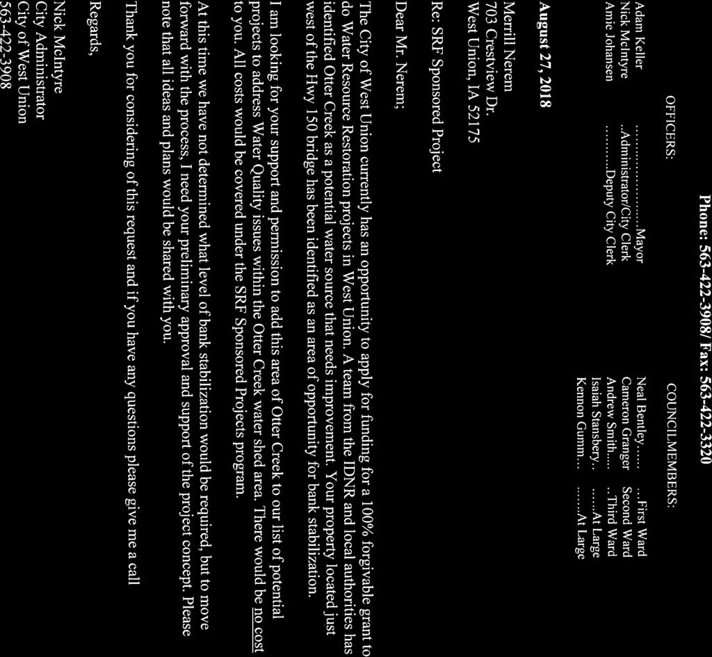
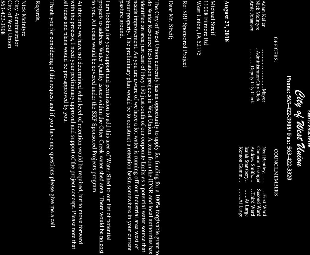
13 Discussion of project locations, land ownership, and any plans for acquiring properties or easements. Potential projects are located on properties that are owned or controlled by the City of West Union or on private properties with willing property owners. The Plaza parking area is privately owned, but is maintained by the City. The streambank stabilization project along Otter Creek and the site for the stormwater wetland across from the industrial park are both currently owned by private landowners. The City plans to develop agreements with each landowner to address land impacted by the project, maintenance agreements, and ownership/easements of the project sites. Identification of any other organizations or resources to be involved in the project and their expected contributions. Recognizing the water quality and flooding issues in the Turkey River Watershed (TRW), twenty-three communities, including West Union, seven Soil and Water Conservation Districts and five County Board of Supervisors formed the largest Watershed Management Authority (WMA) in Iowa in The thirty-five TRWMA partners have worked since that time to develop a 20-year Watershed Resiliency Plan, which they published in 2016 and continue to implement. Stormwater best management practices that improve water quality were included in the Watershed Resiliency Plan as a way for TRWMA communities to reduce their impact on the rivers and streams in the TRW. The Fayette Soil and Water Conservation District supports the ongoing efforts of the City to improve water quality. Monthly water monitoring conducted by SWCD staff at 12 sites in the TRW in Fayette County, including at the mouth of Otter Creek in Elgin, from 2012 to helps local and state partners understand how to address and manage water quality and hydrologic issues throughout the watershed. Monitoring parameters include transparency and total suspended solids, which helps the WMA partners understand the sediment load carried by the streams and the river. The Iowa Flood Center (IFC) has also completed complex hydrologic modeling of Otter Creek and the entire TRW, which is one of four watersheds in Iowa targeted by the IFC for hydrologic modeling, including the proposed project area. The TRWMA, IFC, Fayette County, and Fayette SWCD worked together to implement 37 best management practices in mostly rural areas of the Otter Creek Watershed that will help improve water quality and reduce flooding. Stormwater practices implemented by the City of West Union not only complement these efforts but help to galvanize the rural and urban residents in participating in watershed protection.
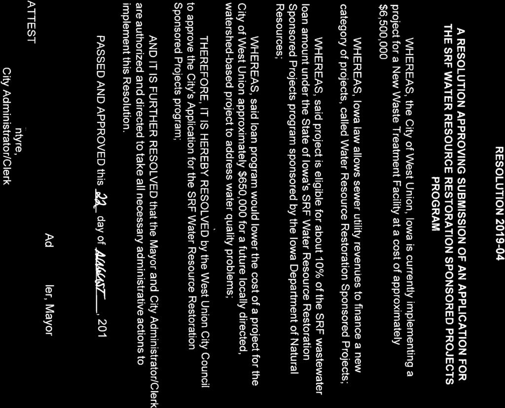
14 Proposed project schedule with major milestones, along with a discussion of how the sponsored project construction schedule coordinates with the infrastructure project schedule. The wastewater treatment plant construction is expected to begin in the spring or summer of This project could be completed at the same time or just after the wastewater plant. Final Design, Specifications and Contract Doc. Preparation: Fall 2018 Wastewater Bid Process: Winter 2018/2019 Finalize prioritization and design of sponsored projects Spring 2019 Finalize SRF loan amount and begin construction Spring 2019 Bid sponsored projects Fall 2019 Sponsored projects begin construction: Spring 2020 Completion of Construction: Fall 2020 Proposed evaluation procedures and measures. Project sites will be visually inspected during rain events to monitor runoff and determine whether additional infiltration practices are necessary. The City of West Union will investigate potential means of monitoring the overflow drain line to determine flow reduction. The drain will be equipped with a gate to allow full control of the discharge rate. A monitor was placed at the outlet of the existing storm water management projects to record the volume of runoff leaving the project area. The Iowa Flood Center/IIHR was responsible for monitoring this data. According to the data collected by the monitor, discharge volume is reduced 60-90% from the project area already treated by stormwater BMPs. A similar result is expected from the permeable pavers and bioretention areas installed as part of this project. The City is in ownership of specialized equipment to properly maintain and clean their existing permeable pavers and will use this equipment on any newly installed pavers. Explanation of the proposed budget, including other planned funding sources and flexibility to adjust budget according to final amount available through sponsored project mechanism. The City of West Union is requesting $650,000 from the SRF sponsored project program. Of the total requested funds, $50,000 is allocated to professional planning, legal, and administrative, $56,000 is allocated for project design, and $52,000 is allocated for professional construction fees. The remaining $492,000 is allocated for project construction of which $45,000 is included for potential contingencies during project construction. The city has prioritized project locations or areas and practices that will complement existing practices and help achieve the city s goals of reducing sediment, nutrients, and other pollutants entering nearby surface waters. Estimated costs for each project will be determined when final engineering and project design are completed for the priority practices. The City of West Union recognizes that the amount requested in this proposal may not be sufficient to complete all of the listed priority practices. City officials are committed to seeking further funding through other programs and grants to implement projects in the future not funded by SRF sponsored project funds.
15 Preliminary communication plan indicating how information about the proposed project will be communicated to and from key audiences, such as community residents, neighbors, city council or other decision makers, and other stakeholder groups The City Administrator and contracted engineering firm, Fehr Graham, will be the primary contacts for planning and communicating project plans, finalizing sponsored project practices, securing landowner agreements, and communication with the West Union City Council and Mayor and with SRF Sponsored Projects Staff. The City has stormwater interpretation at existing practice locations in the downtown area that will help educate residents and visitors about the functionality of stormwater BMPs and the connection to local streams. The City will explore options for additional on-site interpretive materials for new BMP locations. The City of West Union will continue participating as an active member of the TRWMA. Through the TRWMA, City representatives will attend public meetings, TRWMA board meetings, and events in the watershed to share ideas with other communities in the watershed and region. Project activities will be shared with the River Bluffs Scenic Byway and Turkey River Recreational Corridor boards to demonstrate regional cooperation for protecting natural resources.
16

17
18

19
20

21 Lee Wagner DNR State Revolving Fund Coordinator Iowa Department of Natural Resources 401 SW 7 th Street, Suite M Des Moines, IA August 28th, 2018 Dear Mr. Wagner: The Turkey River Watershed Management Authority is strongly in support of the City of West Union s application to the SRF Sponsored Project Program. The projects West Union is proposing would complement the efforts of the WMA and their partners to improve water quality in the Turkey River and its tributaries. The WMA, along with Fayette SWCD, NRCS, the Iowa Flood Center, and Iowa Economic Development Authority, recently completed 37 projects in the Otter Creek Watershed to reduce flash flows and improve water quality. The WMA will adopt this project as part of the comprehensive Turkey River Watershed Resiliency Plan and help promote the project to other community officials in the watershed. This project will serve as an example to other communities about the SRF Sponsored Project Program and how to incorporate stormwater best management practices into small communities. West Union is an active participant in Turkey River Watershed Management Authority activities since its formation in The TRWMA Board of Directors is made up of 35 entities including 23 communities, 8 counties and 7 Soil and Water Conservation Districts. The TRWMA completed and adopted a Watershed Resiliency Plan with the expressed goals of flood reduction and water quality improvement. Thank you for your consideration Sincerely, Rod Marlatt, Chair Turkey River Watershed Management Authority P.O. BOX E. GREENE STREET POSTVILLE, IOWA PHONE:
Monica Smith, PE President Robinson Engineering Company
 Monica Smith, PE President Robinson Engineering Company Owner Robinson Engineering Masters Degree in Water Resource Management for Colorado State University The Dry Run Creek project got me interested
Amy Bouska Urban Conservationist IDALS-Division of Soil Conservation
 Amy Bouska Urban Conservationist IDALS-Division of Soil Conservation Wayne Petersen Wallace Building, Des Moines 515-281-5833 Wayne.petersen@iowaagriculture.gov Derek Namanny Spirit Lake FO 712-336-3782
When planning stormwater management facilities, the following principles shall be applied where possible.
 2.0 Principles When planning stormwater management facilities, the following principles shall be applied where possible. 2.0.1 Drainage is a regional phenomenon that does not respect the boundaries between
Storm Water Quality and Shoreline Restoration Improvements - Grant Funding Request City of Mound Carlson Park Bolton & Menk Project No.
 September 15, 2016 Brett Eidem Cost Share Grant Administrator Minnehaha Creek Watershed District 15320 Minnetonka Boulevard Minnetonka, MN 55345 RE: Storm Water Quality and Shoreline Restoration Improvements
7.0 SOCIAL, ECONOMIC, AND ENVIRONMENTAL ISSUES
 7.0 SOCIAL, ECONOMIC, AND ENVIRONMENTAL ISSUES The following list of social, economic, and environmental issues have been identified based on a preliminary inventory of resources in the project area, an
Post Construction BMPs
 Post Construction BMPs Why are Post Construction BMPs important? With increased development brings the increase of impervious cover Parking lots, rooftops, driveways Storm water runoff volume increases
UNIVERSITY OF NORTHERN IOWA
 UNIVERSITY OF NORTHERN IOWA Municipal Separate Storm Sewer System September 2008 Report Permit Number 07-09-0-04 August 2008 Prepared by: University of Northern Iowa Environmental Health and Safety Office
HEALTH SCIENCES BUILDING REDEVELOPMENT PROJECT
 INTRODUCTION In recent years, the University of Cincinnati (University) has demonstrated a commitment to identifying and implementing sustainable goals and objectives throughout University s Uptown Campuses.
Bioretention cell schematic key
 Bioretention Cells Bioretention cell schematic key 1 3 Hardwood mulch 2 Curb cut 3 18-30 Modified soil 4 Stone aggregate choker layer 5 Stone aggregate base layer 6 Subdrain 7 Undisturbed soil 8 Overflow/Cleanout
The Benefits and Challenges Associated with Green Infrastructure Practices
 The Benefits and Challenges Associated with Green Infrastructure Practices Thomas M. Evans ASLA, LEED AP Regional Green Infrastructure Design Services Director OWEA Technical Conference, June 20, 2013
HUDSON VALLEY REGIONAL COUNCIL 3 Washington Center, Newburgh NY
 PROJECT AREA: HYDE PARK HUDSON VALLEY REGIONAL COUNCIL 3 Washington Center, Newburgh NY 12550 http://www.hudsonvalleyregionalcouncil Insert aerial site photo with streets labeled GREEN INFRASTRUCTURE CONCEPT
Lake and Stream Restoration Project
 Pre-project Fact Sheet May 2012 Toledo Botanical Garden (TBG) is a 60 acre public garden visited by more than 120,000 people annually. It is located in Toledo, Ohio in the Ottawa River watershed within
LOUISIANA STATE UNIVERSITY COMPREHENSIVE & STRATEGIC CAMPUS MASTER PLAN. APPENDIX G - Stormwater Study Findings & Stormwater Solutions
 LOUISIANA STATE UNIVERSITY COMPREHENSIVE & STRATEGIC CAMPUS MASTER PLAN APPENDIX G - Stormwater Study Findings & Stormwater Solutions LSU: MP Narrative July 2017 3.5 Open Space Existing Conditions The
Riparian Buffer on the Bushkill Creek. Policies
 Riparian Buffer on the Bushkill Creek Riparian buffers provide numerous benefits to landowners and the community by protecting groundwater recharge areas, providing flood control, providing stormwater
Green Infrastructure. NYS Department of Environmental Conservation
 Green Infrastructure Green infrastructure is an interconnected network of natural areas and open spaces that sustains ecosystems. Benedict, M.A. and E.T. McMahon. 2006. Green Infrastructure Linking Landscapes
Town of Vershire Road Erosion Inventory Report
 Town of Vershire Road Erosion Inventory Report Taylor Valley Road. Photo taken by TRORC staff. Prepared by: 128 King Farm Road Woodstock, VT 05091 Inventory and report funded by the Vermont Agency of Transportation
ADOPTED CAPITAL IMPROVEMENT PROGRAM BUDGET ARROYO PROJECTS
 ADOPTED CAPITAL IMPROVEMENT PROGRAM BUDGET ARROYO PROJECTS HAHAMONGNA FY 212-216 Capital Improvement Program Priority Description Total Estimated Costs Appropriated Through FY 211 Adopted FY 212 FY 213
MUNICIPAL SEPARATE STORM SEWER SYSTEM 2008 ANNUAL REPORT
 MUNICIPAL SEPARATE STORM SEWER SYSTEM 2008 ANNUAL REPORT Permit Number 85-03-0-04 March 2009 Prepared by: Iowa State University Department of Environmental Health and Safety 2809 Daley Drive Ames, Iowa
BE WATER WISE. Managing Your Onlot Stormwater. Sept. 23, 2006 Watershed Weekend
 BE WATER WISE Managing Your Onlot Stormwater Sept. 23, 2006 Watershed Weekend 2006 1 All water resources are interrelated through the Hydrologic Cycle Sept. 23, 2006 Watershed Weekend 2006 2 What is Storm
Pennsylvania Stormwater Best Management Practices Manual. Chapter 1. Introduction and Purpose
 Pennsylvania Stormwater Best Management Practices Manual Chapter 1 Introduction and Purpose Chapter 1 Introduction and Purpose 1.1 Purpose of this Manual 1 1.2 How to Use this Manual...1 1.3 Overview
One County s Success in Linking Watershed Protection and Land Use Planning
 One County s Success in Linking Watershed Protection and Land Use Planning Bob Thompson Porter County Plan Commission March 28, 2012 Indiana Watershed Leadership Academy Population 160,000 Approximately
Stormwater Management Techniques WMPF LAND USE TRAINING INSTITUTE MARCH 14, 2018
 Stormwater Management Techniques WMPF LAND USE TRAINING INSTITUTE MARCH 14, 2018 Potential Impacts of New Development Urban development can significantly increase stormwater runoff Water quality considerations
The following principles guide the development of goals and strategies to protect and promote these amenities:
 OPEN SPACE/PARKS/TRAILS/RECREATION GOALS/STRATEGIES Cherry Hills Village is a living environment that offers low density development, open areas, public scenic vistas, public trails and public parks. This
New Development Stormwater Guidelines
 New Development Stormwater Guidelines CITY OF MOUNTLAKE TERRACE Table of Contents Introduction... 2 Ecology s Minimum Requirements for stormwater management... 2 Description of the 9 Minimum Requirements...
Potential Green Infrastructure Strategies May 6, 2015 Workshop
 Potential Green Infrastructure Strategies May 6, 2015 Workshop Background The City of Cortland is developing the Tioughnioga Urban Headwaters Green Infrastructure Action Plan with funding from the National
Stormwater Management at The University of New Orleans
 University of New Orleans ScholarWorks@UNO DRU Workshop 2013 Presentations Disaster Resistant University Workshop: Linking Mitigation and Resilience Conferences and Workshops 3-1-2013 Stormwater Management
Town of Peru Comprehensive Plan Executive Summary
 Town of Peru Comprehensive Plan Executive Communities that plan grow by choice, not by chance. A plan makes growth thoughtful, understandable, and predictable. A plan shows that a community is managing
Improve Neighborhood Design and Reduce Non Point Source Water Pollution
 HOW TO Planning Guide Improve Neighborhood Design and Reduce Non Point Source Water Pollution This document was funded by a grant from the New Hampshire Coastal Program with funding from the National Oceanic
Checklists. Project Name: Location: File Number: Date of Submittal: Reviewer: Date: Applicant: Contact Name: Phone Number:
 Applicant: Contact Name: Phone Number: Email: Project Name: Location: File Number: Date of Submittal: Reviewer: Date: Concept Plan Requirements: I. General Project Information 1. Address or parcel number
National Fish & Wildlife Foundation Delaware River Restoration Fund 2014 Award Descriptions
 National Fish & Wildlife Foundation Delaware River Restoration Fund 2014 Award Descriptions Restoring Paulins Kill Floodplain Forests and Functions ( Highlands) $99,759 Barrett s Run Afforestation and
HAZARD MITIGATION GOALS AND OBJECTIVES
 SEWRPC Community Assistance Planning Report No. 282, 2nd Edition CITY OF MILWAUKEE ALL HAZARDS MITIGATION PLAN UPDATE Chapter IV HAZARD MITIGATION GOALS AND OBJECTIVES [NOTE: Throughout this plan update
ST. MARY S SOIL CONSERVATION DISTRICT (SMSCD) AND DPW&T CONCEPT EROSION AND SEDIMENT CONTROL AND STORMWATER MANAGEMENT GUIDELINES AND CHECKLIST
 AND DPW&T CONCEPT EROSION AND SEDIMENT CONTROL AND STORMWATER MANAGEMENT GUIDELINES AND CHECKLIST") St. Mary s Soil Conservation District 26737 Radio Station Way, Suite B Leonardtown, MD 20650 Phone: 301-475-8402 ext. 3 Fax: 301-475-8391 www.stmarysscd.com St. Mary s County Government Department of Public
St. Mary s Soil Conservation District 26737 Radio Station Way, Suite B Leonardtown, MD 20650 Phone: 301-475-8402 ext. 3 Fax: 301-475-8391 www.stmarysscd.com St. Mary s County Government Department of Public
6.5 Lakewood Gulch. Basin Snapshot
 6.5 Lakewood Gulch The Lakewood Gulch Map Unit is comprised of both Lakewood Gulch and Dry Gulch (4800-01 and 4801-01) from the Denver Storm Drainage Master Plan (SDMP) and has a total drainage area of
The West Vaughan Employment Area Secondary Plan Policies
 Part 2: The West Vaughan Employment Area Secondary Plan Policies 2.1 General Policies It is the policy of Council: 2.1.1. That the West Vaughan Employment Area (the WVEA), identified on Schedule 1, will
A Review of Green Infrastructure Projects Implemented in the Grand Traverse Region
 A Review of Green Infrastructure Projects Implemented in the Grand Traverse Region Sarah U Ren Program Director The Watershed Center of Grand Traverse Bay 231-935-1514, suren@gtbay.org Our Mission: The
Craven Street Stormwater Improvement Projects
 Craven Street Stormwater Improvement Projects The Craven Street Watershed drains the area from Haywood Road to Westwood Place and down Haywood to the French Broad River. The watershed has one main un-named
USF System Campus Master Plan Updates Goals, Objectives and Policies
 2015-2025 USF System Campus Master Plan Updates Goals, Objectives and Policies Tampa Goals, Objectives, and Policies Table of Contents Executive Summary 2015 2025 USF Campus Master Plan Update Introduction
Mendota Heights 2040 Comprehensive Plan Draft Vers
 4 Parks and Trails The City of Mendota Heights boasts a variety of recreational and open space opportunities. Few cities can claim access to regional trails, riverside and lakeside parks, scenic bluffs
Gaining Consensus for Green Infrastructure Rain to Recreation
 Gaining Consensus for Green Infrastructure Rain to Recreation May 2nd, 2017 Tom Jacobs, PE, CFM Stormwater Engineer City of Lenexa Ronald L Norris, PE, PWLF Affiliated with Shockey Consulting Rain to Recreation:
Leduc Industrial Outline Plan SE W4
 Leduc Industrial Outline Plan SE 1-50-25-W4 Within the North Leduc Industrial ASP Prepared for: Leduc Energy Park Ltd. Prepared by: Stantec Consulting Ltd. File No. 1161 104655 V5 Table of Contents 1.0
Climate Smart Communities Green Infrastructure Case Studies
 New York State Water Resources Institute Climate Smart Communities Green Infrastructure Case Studies Emily Vail Hudson River Estuary Program NYS Department of Environmental Conservation Cornell University
Appendix E: Illustrative Green Infrastructure Examples
 Appendix E: Illustrative Green Infrastructure Examples Integrating LID into San Francisco s Urban Landscape Figure E. High-density Residential Figure E. Low-density Residential Figure E. Mixed Use 7 Figure
Green Infrastructure Recommendations For Parks and Public Spaces
 Green Infrastructure Recommendations For Parks and Public Spaces Issued by the Jersey Water Works Green Infrastructure Committee And Prepared by Meliora Design This document recommends ways to integrate
Urban Water Management (ESRM 311 & SEFS 507) Cougar Mtn Regional Wildland Park & Lakemont Blvd, Bellevue WA
 Cougar Mtn Regional Wildland Park & Lakemont Blvd, Bellevue WA") Urban Water Management (ESRM 311 & SEFS 507) Cougar Mtn Regional Wildland Park & Lakemont Blvd, Bellevue WA Lecture Today Urban Water management terms Examples of water management in urban areas Field
Urban Water Management (ESRM 311 & SEFS 507) Cougar Mtn Regional Wildland Park & Lakemont Blvd, Bellevue WA Lecture Today Urban Water management terms Examples of water management in urban areas Field
Urban Water Management and Soils (ESRM 311 & SEFS 507)
") Urban Water Management and Soils (ESRM 311 & SEFS 507) Cougar Mtn Regional Wildland Park & Lakemont Blvd, Bellevue WA Lecture Today Some Urban Water management terms Examples of water management in urban
Urban Water Management and Soils (ESRM 311 & SEFS 507) Cougar Mtn Regional Wildland Park & Lakemont Blvd, Bellevue WA Lecture Today Some Urban Water management terms Examples of water management in urban
Green Infrastructure Policies and Ordinances
 Green Infrastructure Policies and Ordinances October 23, 2013 By Karen Firehock, Green Infrastructure Center 2013 Georgia Urban Forest Council s 23 rd Annual Conference The mission of the nonprofit Green
Funding Assistance to Stormwater Utility Fee Payers for Stormwater Solutions and Incentives. Danny Bowden City of Raleigh Stormwater Utility
 Funding Assistance to Stormwater Utility Fee Payers for Stormwater Solutions and Incentives Danny Bowden City of Raleigh Stormwater Utility Raleigh stormwater utility s cost share programs Drainage repairs
Old Mill Community Association Bioretention Facility
 Project Overview This project will install a bioretention facility in a community recreation area owned by the Old Mill Community Association, Inc. Drainage from the area is currently unmanaged and has
4.6. Low Impact and Retentive Grading
 4.6. Low Impact and Retentive Grading Low Impact Grading techniques focus on utilizing existing topography during Site layout to minimize cost. Proposing structures, roads, and other impervious surfaces
MUNICIPAL SEPARATE STORM SEWER SYSTEM 2009 ANNUAL REPORT
 MUNICIPAL SEPARATE STORM SEWER SYSTEM 2009 ANNUAL REPORT Permit Number 85 03 0 04 March 2010 Prepared by: Iowa State University Department of Environmental Health and Safety 2809 Daley Drive Ames, Iowa
2008 Combined Clean Water Legacy Grant Application Id#: Use TAB key to move from field to field
 cwl funds - CWL_FY08Application.doc Page 1 2008 Combined Clean Water Legacy Grant Application Id#: Use TAB key to move from field to field 1. Applicant Organization Applicant Organization:THREE RIVERS
Yadkin River Greenway Feasibility Study Fact Sheet Village of Clemmons, Town of Lewisville, Town of Bermuda Run
 Fact Sheet Village of Clemmons, Town of Lewisville, Town of Bermuda Run Project Background The Yadkin River Greenway Feasibility Study is a joint project with the Village of Clemmons, the Town of Bermuda
Ten Mile Creek Planning Area
 PLANNING AREA POLICIES TEN MILE CREEK Ten Mile Creek Planning Area Location and Context The Ten Mile Creek Planning Area ( Ten Mile Creek area ) is located south of the current Boise AOCI, generally south
Huntington Stormwater Utility
 Huntington Stormwater Utility Stormwater Management & Sediment and Erosion Control Requirements for Construction Sites Authorized by Huntington City Code Articles: 971, 970, 930, 935, 955, Revised April
APWA Expo August 27, Ground Water Recharge With Storm Management: A Sustainable Development
 APWA Expo August 27, 2013 Ground Water Recharge With Storm Management: A Sustainable Development Presented by: Joel S. Koenig, P.E. Andrew J. Hawkins Chris P. Dagiantis, P.E., CFM Bios Joel S. Koenig,
{Best Practices. Summary of Tools, Strategies and Best Practices from 11 Michigan Case Study Communities
 Case Studies Michigan Coastal Community Working Waterfronts { Summary of Tools, Strategies and from 11 Michigan Case Study Communities Table of Contents Zoning...2 Community and Stakeholder Collaboration
Horsley Witten Group Sustainable Environmental Solutions. Rich Claytor, P.E. Janet Bernardo, P.E. horsleywitten.com
 Horsley Witten Group Sustainable Environmental Solutions Rich Claytor, P.E. Janet Bernardo, P.E. horsleywitten.com 857-263-8193 Agenda Introduction & Grant Goals Stormwater & GI Overview Grant Work Completed
Appendix I. Checklists
 Appendix I Checklists Town of Greenwich Drainage Manual Department of Public Works - Engineering Division Town Hall - 101 Field Point Road, Greenwich, CT 06836-2540 Phone 203-622-7767 - Fax 203-622-7747
This page intentionally blank.
 This page intentionally blank. Parks, Recreation, and Open Space Chapter Relationship to Vision Vision Parks, Recreation and Open Space Chapter Concepts County Government. County government that is accountable
STREAM BANK STABILIZATION THORPS MORTIMER RECREATION AREA Grandfather Ranger District SITE LOCATION & DRAINAGE AREA
 STREAM BANK STABILIZATION THORPS CREEK @ MORTIMER RECREATION AREA SITE LOCATION & DRAINAGE AREA SITE LOCATION Drainage Area = 1.14 sq. miles STREAM BANK STABILIZATION THORPS CREEK @ MORTIMER RECREATION
Draft Rhode Island Stormwater Design and Installation Standards Manual
 Draft Rhode Island Stormwater Design and Installation Standards Manual Summary The May 2009 Public Review Draft version of the RI Stormwater Design and Installation Standards Manual consists of approximately
TOWN OF SPRINGFIELD, NEW HAMPSHIRE
 TOWN OF SPRINGFIELD, NEW HAMPSHIRE NATURAL RESOURCES INVENTORY EXECUTIVE SUMMARY March 2008 Prepared by: Watershed to Wildlife, Inc. Natural Resource Consultants 42 Mill Street, Suite 3 Littleton, NH 03561
Beyond Rain Gardens Advancing the Use of Compost for Green Infrastructure, Low Impact Development, & Stormwater Management
 Beyond Rain Gardens Advancing the Use of Compost for Green Infrastructure, Low Impact Development, & Stormwater Management VORS 2018 Stormwater Management Session 2 Stormwater Management, Green Infrastructure,
LOW IMPACT DEVELOPMENT TOOLS FOR VERMONT TOWNS
 LOW IMPACT DEVELOPMENT TOOLS FOR VERMONT TOWNS Low Impact Development (LID) is an approach to managing stormwater runoff based on strategies that mimic natural hydrologic processes. LID provides an alternative
November 29, 2007 Brad Jensen, Executive Director Jennifer Muladore, Ecologist Huron Pines
 November 29, 2007 Brad Jensen, Executive Director Jennifer Muladore, Ecologist Huron Pines Huron Pines: Conserving the Forests, Lakes and Streams of Northeast Michigan Nonprofit, 501(c)(3) organization
Pittsfield Action Plan (West Branch of the Housatonic River)
") An initiative of the Massachusetts Executive Office of Energy and Environmental Affairs in partnership with the City of Pittsfield Pittsfield Action Plan (West Branch of the Housatonic River) The spring
An initiative of the Massachusetts Executive Office of Energy and Environmental Affairs in partnership with the City of Pittsfield Pittsfield Action Plan (West Branch of the Housatonic River) The spring
PLANNING AND NATURAL RESOURCES COMMITTEE. Public Access Conceptual Design Alternatives for the Red Barn Area of La Honda Creek Open Space Preserve
 PLANNING AND NATURAL RESOURCES COMMITTEE R-17-56 May 9, 2017 AGENDA ITEM AGENDA ITEM 2 Public Access Conceptual Design Alternatives for the Red Barn Area of La Honda Creek Open Space Preserve GENERAL MANAGER
A Vision for Walnut Creek
 A Vision for Walnut Creek Photo: City of Clive Walnut Creek Booklet 8 of 8 Greater Des Moines Water Trails and Greenways 1 Table of Contents Booklet 1: Water Trails Strategies and Policies Booklet 2: Beaver
Landowner's Guide to the Lower St. Croix Riverway. Protect. Restore. Celebrate. stcroixriverassociation.org
 Landowner's Guide to the Lower St. Croix Riverway Protect. Restore. Celebrate. stcroixriverassociation.org Cover and page spread photographs by Craig Blacklock. For more information on how to be a river
Community LID Workgroup Issue Paper #6
 Community LID Workgroup Issue Paper #6 Topic: Hard and Impervious Surface Coverage Limits Objective: Minimize the amount of hard and impervious surfaces in developments to allow more stormwater to infiltrate
Section 3 Non-Structural BMPs
 3.1 Stream Buffers A stream buffer or stream setback is a designated area around a stream, lake, or wetland left in a natural, densely vegetated state so as to protect the receiving water quality and provide
FAQ S about Restoration Planning FROM THE Department of Ecology WEBSITE:
 FAQ S about Restoration Planning FROM THE Department of Ecology WEBSITE: http://www.ecy.wa.gov/programs/sea/sma/st_guide/smp/restoration/qanda.html Notations in parentheses are staff notes directing you
Sustainable Stormwater Management through Green Infrastructure. Jersey City Public School #5
 Green Infrastructure Site Evaluation Friday, October 25 th, 2013 Sustainable Stormwater Management through Green Infrastructure Jersey City Public School #5 FORMAT: (15 minutes) An Introduction to Stormwater
Slope Stability Management Framework
 Slope Stability Management Framework For the assessment, evaluation, prioritization and mitigation of slope stability concerns. 2013/06/19 The Slope Stability Management Framework provides guidance to
Presentation Item C Annotated Model Outline for a Framework for a Green Infrastructure Plan
 Date: August 17, 2016 To: From: Subject: Management Committee Dan Cloak, Consultant Presentation Item C Annotated Model Outline for a Framework for a Green Infrastructure Plan Recommendation: Receive the
The Community Conservation Assistance Program (CCAP) in North Carolina
 in North Carolina") The Community Conservation Assistance Program (CCAP) in North Carolina 17 River Basins Background on the State and Water Quality Issues 550+ Municipalities 9,765,000 Residents 13 Congressional Districts
The Community Conservation Assistance Program (CCAP) in North Carolina 17 River Basins Background on the State and Water Quality Issues 550+ Municipalities 9,765,000 Residents 13 Congressional Districts
Lewisville Lake Master Plan Revision Public Information Meeting May 2 & 4, 2017
 Lewisville Lake Master Plan Revision Public Information Meeting May 2 & 4, 2017 Presented By Rob Jordan Lake Manager U.S. Army Corps of Engineers Fort Worth District US Army Corps of Engineers Purpose
COMMUNITY SUSTAINABILITY AND ENVIRONMENTAL MASTER PLAN IMPLEMENTATION UPDATE
 Attachment 1 COMMUNITY SUSTAINABILITY AND ENVIRONMENTAL MASTER PLAN IMPLEMENTATION UPDATE Priorities and Key Initiatives Committee May 2013 Page E-1 How we grow Goal 2: To ensure sustainable development
City of Iowa City Department of Neighborhood and Development Services Department of Parks and Recreation Department of Public Works City Manager s
 RFP Pre-submittal meeting December 18, 2015 City of Iowa City Department of Neighborhood and Development Services Department of Parks and Recreation Department of Public Works City Manager s Office Background
2011 ASLA Design Awards. Westside Creeks Restoration Plan Merit Award AECOM, Fort Collins. Planning & Urban Design
 2011 ASLA Design Awards Westside Creeks Restoration Plan Merit Award AECOM, Fort Collins Planning & Urban Design Project Fact Sheet Category of Entry: Rotating Specialty Award: 2011 2011 ASLA Colorado
Swan Creek Urban BMP Inventory and Assessment. Jeff Grabarkiewicz, Kari Gerwin, Ann-Drea Hensley TMACOG, Lucas SWCD/Engineers, and Partners
 Swan Creek Urban BMP Inventory and Assessment Jeff Grabarkiewicz, Kari Gerwin, Ann-Drea Hensley TMACOG, Lucas SWCD/Engineers, and Partners Presentation Outline Project Background Methods Inventory Desktop
Boardman River Watershed VILLAGE OF KALKASKA. WATER QUALITY ACTION PLAN Fall 2009
 Boardman River Watershed VILLAGE OF KALKASKA WATER QUALITY ACTION PLAN Fall 2009 Partners: The Watershed Center Grand Traverse Bay Northwestern Michigan College - Great Lakes Water Studies Institute Grand
2016 Comprehensive Plan Amendments C OMPREHENSIVE P LAN T EXT AND M AP A MENDMENT
 2016 Comprehensive Plan Amendments T EXT A MENDMENTS D ISTILLERIES IN R URAL P OLICIES #844110 LID POLICIES #844112 M AP A MENDMENTS B ETHEL S CHOOL D ISTRICT #844237 P ARKS AND R ECREATION #844305 C OMPREHENSIVE
Stormwater Runoff and the District of Columbia RiverSmart Homes Defined:
 Stormwater Runoff and the District of Columbia Stormwater runoff is rainwater that flows off impervious surfaces such as rooftops, driveways, roads, sidewalks and sometimes even lawns. Stormwater runoff
An Ambitious Plan: Transforming the blighted South Platte River and surrounding environment into Denver s greatest natural resource.
 CONNECTING THE PEOPLE TO THEIR RIVER SOUTH PLATTE RIVER VISION IMPLEMENTATION PROGRAM: GRANT-FRONTIER PARK TO OVERLAND POND PARK REACH The South Platte River Vision Implementation Program (River Vision)
NEW YORK STATE WATER RESOURCES INSTITUTE Department of Biological and Environmental Engineering
 NEW YORK STATE WATER RESOURCES INSTITUTE Department of Biological and Environmental Engineering 230 Riley-Robb Hall, Cornell University Tel: (607) 254-7163 Ithaca, NY 14853-5701 Fax: (607) 255-4449 http://wri.cals.cornell.edu
Minnesota Department of Natural Resource - Natural Resource Guidance Checklist Conserving Natural Resources through Density Bonuses
 Minnesota Department of Natural Resource - Natural Resource Guidance Checklist Conserving Natural Resources through Density Bonuses NRDB Why Use Density Bonuses & This Checklist Local units of government
Arkansas River Corridor
 Planning for Access Welcome to the Access Project. This project is a recreational planning effort in response to an interest by regional communities along the Arkansas River corridor. The project plan
Town of Hague Stormwater Outfall Evaluation Report
 Town of Hague Stormwater Outfall Evaluation Report Prepared by the Warren County Soil and Water Conservation District For the Town of Hague and the Lake George Park Commission November 2012 Table of Contents
Green Streets. Sustainable Stormwater Solutions for Greener Communities and a Cleaner Bay
 Green Streets Sustainable Stormwater Solutions for Greener Communities and a Cleaner Bay As the Bay Area continues to grow through development of roads, revitalization of neighborhoods, and construction
Rain Gardens. A Welcome Addition to Your Landscape
 Rain Gardens A Welcome Addition to Your Landscape Where Does The Rainwater Go? Naturally, forests provide a way for rainwater to percolate into the soil, filtering pollutants while trees are allowed to
METROPOLITAN COUNCIL 390 North Robert Street, St. Paul, MN Phone (651) ; TDD (651)
 ; TDD (651)") DATE: October 24, 2012 METROPOLITAN COUNCIL 390 North Robert Street, St. Paul, MN 55101 Phone (651) 602-1000; TDD (651) 291-0904 TO: Metropolitan Parks and Open Space Commission FROM: Tori Dupre, Senior
DATE: October 24, 2012 METROPOLITAN COUNCIL 390 North Robert Street, St. Paul, MN 55101 Phone (651) 602-1000; TDD (651) 291-0904 TO: Metropolitan Parks and Open Space Commission FROM: Tori Dupre, Senior
ARROYO PROJECTS ADOPTED CAPITAL IMPROVEMENT PROGRAM BUDGET
 A RROYO P ROJECTS ADOPTED CAPITAL IMPROVEMENT PROGRAM BUDGET FISCAL YEARS 214-218 HAHAMONGNA Priority Description 1 Hahamongna Watershed Park - Implement Master Plan 211,6 211,6 (77565) 2 Hahamongna -
2016 WORKSHOP LVR Field Trip
 2016 WORKSHOP LVR Field Trip ***Note*** Many of the sites on this tour were NOT related to, or funded by, the DGLVR program. They are being shown to encourage discussion about the kinds of projects that
Work Plan. Introduction:
 Work Plan Introduction: The original construction of Santa Rosa s City Hall was done in an era when storm water was collected and conveyed as quickly as possible, where water intensive lawns were the norm,
Jill Stachura STORMWATER BMP AND STREAM RESTORATION IN A CITY PARK. October 2013 Southeast Stormwater Association Annual Conference, Charlotte, NC
 Jill Stachura STORMWATER BMP AND STREAM RESTORATION IN A CITY PARK October 2013 Southeast Stormwater Association Annual Conference, Charlotte, NC Project Location Gwinnett County, GA: Population: 825,000
Stormwater Management Plan (SWMP) Revision Date: 11/05
 Revision Date: 11/05") Stormwater Management Plan (SWMP) Revision Date: 11/05 SWMP Purpose: Sustainable stormwater management principles are adopted as Portland State University s (PSU) preferred approach for the management
Stormwater Management Plan (SWMP) Revision Date: 11/05 SWMP Purpose: Sustainable stormwater management principles are adopted as Portland State University s (PSU) preferred approach for the management
The Flow. Green Infrastructure Taking Root in Cities 3/23/2015. Green Infrastructure Evolution City Plans/Projects Measureable and Holistic Benefits
 Green Infrastructure Taking Root in Cities Robert Hopper, P.E. CDM Smith The Flow Green Infrastructure Evolution City Plans/Projects Measureable and Holistic Benefits 2 1 Parts, Systems, Whole The first
continues in the watershed, additional flood control and water quality / natural system improvements may be required in the future.
 The Duck Pond Watershed is located in northern Hillsborough County in an area in which a number of land and water management issues are currently being addressed by citizen's action groups and state, regional
Non-Residential&Multi-Family PropertyCreditManual
 CityofRichmond DepartmentofPublicUtilities StormwaterManagementProgram Non-Residential&Multi-Family PropertyCreditManual ApprovedFebruary2011 City of Richmond Stormwater Non-Residential & Multi-Family