Richard Thompson, Director of Community Development Department
|
|
|
- Hilary Russell
- 5 years ago
- Views:
Transcription
1 CITY OF MANHATTAN BEACH DEPARTMENT OF COMMUNITY DEVELOPMENT TO: FROM: BY: Planning Commission Richard Thompson, Director of Community Development Department Laurie B. Jester, Planning Manager DATE: March 27, 2013 SUBJECT: Consideration of Use Permit, Coastal Development Permit, and Lot Line Adjustment, and related utility easement, and to allow demolition of the existing library and construction of a new public County Library and related improvements at the 1320 Highland Avenue. RECOMMENDATION Staff recommends that the Planning Commission CONDUCT the Public Hearing and APPROVE the request for a Use Permit, Coastal Development Permit and Lot Line Adjustment, and RECOMMEND that the City Council accept the exchange of land through the Lot Line Adjustment, and the related utility easement. APPLICANT OWNER County of Los Angeles County of Los Angeles Jason I. Kim, Project Manager Wiliam T. Fujioka, County Representative 900 S. Fremont Avenue, 5th Floor 500 W. Temple Street Alhambra, CA Los Angeles, CA BACKGROUND The County of Los Angeles Manhattan Beach Library project involves the demolition and replacement of the existing public library with a new two-story, 21,500-square foot building that includes a larger community space and more advanced technological resources. On March 12, 2013, the Los Angeles County Board of Supervisors certified an EIR Addendum, approved quitclaims and a grant of easement, approved a budget, and awarded a contract for the Library Project. Role of the Planning Commission The City and the Planning Commission have limited authority over the County Library project. The new Library project requires that the City make the findings for approval of a Use Permit, Coastal Development Permit, and a Lot Line Adjustment. The Planning Commission must adopt Findings that the project is consistent with the goals and policies of the General Plan, the Local Coastal Plan, as well as, the purposes of Zoning Code. The Commission will make recommendations to the City Council who will take final action on the project. 1
2 Project History The County of Los Angeles owns and operates the existing 35-year old, 12,188-square foot Manhattan Beach Library. The reconstruction of the public Library resulted from discussions held with Los Angeles County that the City initiated in the 1990s to implement the City s Facilities Strategic Plan. In 2008, conceptual plans were submitted and in 2010, City Staff proceeded with refining the Library design. By 2011, the location, size, floor plan, and approximate building height for the new Library were established. At meetings in October 2011, the design team, City staff, and County representatives sought input regarding the design of the building s exterior, including the landscape materials, and public art component. Public Input The County has been working cooperatively with the City and the community to develop the design of the Library, and to consider everyone s input and address their needs. On December 8, 2010 the Planning Commission received a status report on the scope and a general design approach of the project. Community meetings were held in September and October 2011, to provide updates on the project budget and schedule as well as solicit public input on the proposed Library project. The Library Commission provided input on the initial layout and floor plan of the proposed library as well as the programs, interior furnishings and aesthetics, and the use of the outside space on the east side of the proposed Library facing the Civic Center Plaza. The Manhattan Beach Cultural Arts Commission and Los Angeles County Arts Commission are working cooperatively to develop an artistic component for the new Library. The existing mosaic mural located at the entrance of the building will be preserved intact and relocated to another site. At the October 12, 2011 Planning Commission meeting, the architect provided information on the building placement, exterior walkways and open spaces, design concept, interior layout and programming, and the relationship to its surroundings including the Civic Center and parking lots. The Planning Commission and community discussed and provided input the building height and its effect on existing views, the exterior cladding, availability/accessibility of parking, and design of the open space on the east side of the building. Project Description The overall design of the proposed library responds to input from the community. The placement of the Library and building shape take into account views from residences along 15 th Street. The building was designed with a mechanical room on the second floor so that the roof would be streamlined and uncluttered. Simulations of the building show the relationship to and views over, the Civic Center plaza, City Hall and adjacent commercial buildings. The main entry was placed at the Northeast corner of the building to create a positive interface with City Hall and the space between the new Library and City Hall will be redesigned to connect the sites. The palm trees along Highland Avenue will be removed and some replaced once the project is near completion. The large Coral tree adjacent to Highland Avenue will be removed as it is within the building footprint of the new Library and the City arborist does not recommend relocation of the tree, and the County has reviewed and approved this recommendation. This will open up some views from residents along 15 th Street. The new library is located further to the west on the property, closer to Highland Avenue which continues the streetscape of building facades along the edge of the sidewalk, as well as opens up a large public park-like open space at the rear, to the east, of the new Library 2
3 The easterly portion of the site is designed to create a transitional space from the Civic Center plaza to the public Library. This area is designed as a public open space with new stairways and a ramp leading down from the plaza to the Library. The park space will be designed as an open area that could accommodate small community events. The area is about half paving next to the building and half is lawn area with large Sycamore trees around the perimeter. Building placement also considered linkages to the community including, vehicle, bicycle, transit and pedestrian modes of transportation. Specifically, pedestrian paths and ramps lead down from the surface parking at the Civic Center plaza level down to the library entrance. The entrance aligns with the proposed relocated crosswalk on Highland Avenue that connects the library to the public parking lot at the corner of 14 th Street. The setback from the building to the south is designed as a walk street and would also be used as service entry for deliveries. The interior layout of the Library is designed to meet the needs of the community. The children s area is located prominently near the entrance on the first floor. A large community meeting room and back of house operations are placed along the southerly half of the first floor that runs parallel to the adjacent commercial building. The Library s teen and adult collections are housed on the second level as well as study rooms, public access computers, staff areas and a mechanical room. From the second floor, the glass-clad exterior capitalizes on ocean views to the west. Partially transparent rolling shades will help minimize solar glare on the interior of the building and reduce reflected glare. Site and Surrounding Area Overview Location 1320 Highland Avenue Existing Land Use Cultural Institution Coastal Zone Non-Appealable General Plan Public Facilities Zoning District Public and Semi-Public District, Area District III Neighboring Zoning North RM, PS Medium Density Residential and Public and Semi- Public Districts (across 15 th Street) West CD, RH Downtown Commercial and High Density Residential Districts (across Highland Avenue) East OS, RS Open Space, Single Family Residential Districts (across Valley/Ardmore) South CD Downtown Commercial District Legal Description(s) Portions of Lots A, B and C (Vacated Alley), Lots 58 thru 62, and 81, and all of Lots 75 thru 80 of Tract 2541, as shown on Map Book 24, Page 86 3
4 DISCUSSION: Budget & Schedule The County of Los Angeles owns and operates the Manhattan Beach Public Library. On March 12, 2013, the Board of Supervisors approved a budget of $26,270,496 for the demolition and construction of the project (Attachment F). The total project cost includes the design-build contract ($18,448,919), awarded to C.W. Driver, Inc. The project is funded through property taxes in the amount of $12,170,496; and bonds in the amount of $14,100,000. On February 11, 2013, the City Council executed a Memorandum of Understanding with the County committing the City s Library property taxes to completion and ongoing operation of the project, including repayment of bonds issued to complete the project. A total of $6.2 million in Surplus Library Taxes has been accumulated to fund the project and an additional $6.0 million is anticipated to be available to fund construction costs. The Library is scheduled to close in June 2013, demolition is set to begin in July 2013, and construction is set to begin in October and last approximately one year with completion in Spring of Temporary Services As soon as the Library closes, and throughout construction of the new Library, temporary library services will be provided. Interim services will include: children's services, express library services (bookmobile) and a variety of online services. County Library representatives assured Staff that the following programs and services can be adjusted or modified to meet the needs of the community. Children's Services will include the popular children's storytime program, maintaining the current service level of two days per week. The Children's Librarian will be dedicating 40 hours per week of service to a variety of programs in Manhattan Beach. Express library services (bookmobile) will include 20 hours per week and allow users to reserve, pick up and checkout books. There will also be a small browsing collection of popular books, periodicals, newspapers, and the ability to perform any business transaction such as signing up for a library card or paying fines. Online services will include a variety of resources including: accessing databases, downloadable ebooks, audiobooks and music, online tutor assistance, reference services, and Ed2Go (free online learning courses). These services may be accessed from computer workstations at the Joslyn Center, City Hall, or from home. For smartphone users, the LA County Library has a phone application that enables users to review library location and hours, search the catalogue, reserve a book, join a summer reading program, ask a librarian a question, view upcoming events and classes, and download ebooks and eaudiobooks and links to Twitter and Facebook. In addition to these services, the City will provide a dedicated reading room at the Joslyn Center and Dial-A-Ride transportation to the Redondo Beach Main Library (which provides reciprocal services for County of Los Angeles Public Library cardholders) and the County s Hermosa Beach Library. 4
5 Land Use Entitlements The City and the Planning Commission have limited authority over the County Library project. The new Library project requires the approval of a Use Permit, Coastal Development Permit, and a Lot Line Adjustment. The General Plan designation of the project site is Public Facilities and the zoning classification is Public and Semi-Public District (PS Zone). The Public Facilities land use category refers to uses operated for public benefit, including public schools, government offices, and public facilities such as libraries, cultural centers, and neighborhood/community centers. Chapter of the Manhattan Beach Municipal Code (MBMC) requires a Use Permit for a library because it is classified as Cultural Institutions use in a PS zone. The Planning Commission will adopt Findings that the project is consistent with the goals and policies of the General Plan, the Local Coastal Plan, as well as, the purposes of Zoning Code, and make recommendations to the City Council. Development Standards The Zoning Code indicates that the development standards for the site are established through the Use Permit review process. The development standards regulate the mass and bulk of proposed buildings through height and setbacks. The following are the proposed height and setbacks from property lines: Height 32 feet, 10 inches* Setbacks North 10 feet East 10 feet West 8 feet, 2 inches South 11 feet, 11 inches *Measured from finished floor level at the front entrance. The Planning Commission is required to make all of the following four findings in order to approve a Use Permit (MBMC ): 1. The proposed location of the use is in accord with the objectives of this title and the purposes of the district in which the site is located; 2. The proposed location of the use and the proposed conditions under which it would be operated or maintained will be consistent with the General Plan; will not be detrimental to the public health, safety or welfare of persons residing or working on the proposed project site or in or adjacent to the neighborhood of such use; and will not be detrimental to properties or improvements in the vicinity or to the general welfare of the city; 3. The proposed use will comply with the provisions of this title, including any specific condition required for the proposed use in the district in which it would be located; and 5
6 4. The proposed use will not adversely impact nor be adversely impacted by nearby properties. Potential impacts are related but not necessarily limited to: traffic, parking, noise, vibration, odors, resident security and personal safety, and aesthetics, or create demands exceeding the capacity of public services and facilities which cannot be mitigated. The Use Permit Findings, findings for consistency with the purpose of the PS Zone, as well as the goals and policies of the General Plan, are included in the draft Resolution (Attachment A). Lot Line Adjustment Lot line adjustments may be granted administratively so long as the parcels resulting from the adjustment conform to local zoning code and building code requirements. As previously mentioned, the Zoning Code does not include prescriptive development standards specifying minimum lot size, lot width or setbacks for properties in the PS zone. Los Angeles County will be issuing the building permit for the proposed public Library and will ensure that the proposed structure meets the requirements of the California Building Code, Los Angeles County Construction Codes, the California Fire Code (with the City of Manhattan Beach amendments) and California Green Building Code (with the City of Manhattan Beach amendments). The lot line adjustments involve quitclaim exchanges of 629 square feet of real property between the County of Los Angeles and the City of Manhattan Beach. In addition, the County will grant a utility easement to the City for existing underground utilities that serve the Civic Center and surrounding area. The City Council will need to accept the land through the Lot Line Adjustment and the utility easement though a grant deed. Coastal Development Permit The City of Manhattan Beach has a certified Local Coastal Program (LCP) and is therefore able to issue our own Coastal Development Permits. The project is not located in the Appealable Area of the Coastal Zone and therefore is not appealable to the California Coastal Commission. Chapter A.96 of the LCP details the requirements for the Coastal Permit including the required findings. The adopted Coastal Policies and Implementation Measures are found in Chapter 4 of the LCP. The draft Resolution includes a listing of the applicable coastal access, transit, and parking policies. Environmental Determination On March 12, 2013, the Los Angeles County Board of Supervisors certified an Addendum to the Environmental Impact Report (EIR) for the Civic Center/ Metlox project (State Clearinghouse No ) in accordance with the requirements of the California Environmental Quality Act. The project description in the Certified EIR included the demolition and reconstruction of the library as part of the Civic Center component of the project. The proposed facility in the certified EIR was approximately 40,000 square feet. The refined public Library project with an area of approximately 21,500 square feet is approximately 46 percent smaller than the previously approved library. The EIR Addendum confirms that the current project adheres to the Facts and Findings of the certified EIR, and includes a mitigation monitoring and reporting program that identifies measures to reduce potential significant impacts associated with the previously approved project. 6
7 Public Notice A public notice for the project was mailed to the property owners within 500 feet of the site and published in the Beach Reporter newspaper. Staff did not receive any comments at the writing of this report. A series of community meetings were held with the Cultural Arts, Planning, and Library Commissions, and the City Council in December 2010 and September and October 2011, to solicit public input on the project (Attachments B and C). Public input was taken into account in terms of site planning and building design as previously discussed. CONCLUSION Staff recommends that the Planning Commission review the information presented in the report, open the public hearing, discuss the project, close the public hearing, and adopt the draft resolution approving the project with conditions. Representatives from the County s architectural team will provide a presentation on the proposed Library project and Los Angeles County staff will be available to answer questions. Attachments: A. Draft Resolution No. PC B. Staff report and attachments for Cultural Arts Commission, Planning Commission, and Library Commission (October 10, 11, 12, 2011) C. Planning Commission meeting minutes for October 12, 2011 D. Chapter E. Master Application Form F. Link to Los Angeles County Board of Supervisors, Board Letter- Agenda Item 27 (March 12, 2013) and attachments: G. Links to Civic Center/Metlox Certified EIR- 2001: and Addendum to Certified Environmental Impact Report 2013-Prepared for the Los Angeles County Board of Supervisors: 7
8 THIS PAGE INTENTIONALLY LEFT BLANK
9 RESOLUTION NO RESOLUTION OF THE PLANNING COMMISSION OF THE CITY OF MANHATTAN BEACH APPROVING A USE PERMIT, COASTAL DEVELOPMENT PERMIT, AND LOT LINE ADJUSTMENT, AND RECOMMENDING THAT THE CITY COUNCIL ACCEPT A UTILITY EASEMENT AND THE QUITCLAIMS FOR THE LOT LINE ADJUSTMENT, TO ALLOW THE DEMOLITION OF THE EXISTING PUBLIC LIBRARY AND CONSTRUCTION OF A NEW PUBLIC LIBRARY AND RELATED IMPROVEMENTS, AT THE CIVIC CENTER SITE HIGHLAND AVENUE. (County of Los Angeles and City of Manhattan Beach) THE PLANNING COMMISSION OF THE CITY OF MANHATTAN BEACH, CALIFORNIA, DOES HEREBY RESOLVE AS FOLLOWS: Section 1. The Planning Commission of the City of Manhattan Beach, California, hereby makes the following findings: A. The County and City are seeking approval of a Use Permit and Coastal Development Permit, to allow the demolition of the existing public Library and construction of a new public Library and related improvements, at 1320 Highland Avenue in the City of Manhattan Beach. B. In accordance with the Manhattan Beach Local Coastal Program MBLCP (Section A ) a Library is classified as a Cultural Institution (Section A C.) and a Use Permit approval is required for the project in the Public and Semi-Public (PS) Zone. C. The subject property is located within the City of Manhattan Beach Coastal Zone, in the nonappealable area, and is subject to a Coastal Development Permit (Section A ). D. The applicant/property owner is the County of Los Angeles and the City of Manhattan Beach is a co-applicant as some of the related improvements are on the adjacent Civic Center property owned by the City of Manhattan Beach at 1400 Highland Avenue. E. The Planning Commission of the City of Manhattan Beach conducted a public hearing regarding the project at their regular scheduled meeting of March 27, The public hearing was advertised pursuant to applicable law and testimony was invited and received. F. An Environmental Impact Report for the Civic Center/ Metlox project was certified by the City of Manhattan Beach City Council on April 17, 2001 (State Clearinghouse No ), which includes the environmental clearance for the public Library project. The Library portion of the project described in the EIR was a 30,018-square foot Library plus a 10,000- square foot, 99-seat Cultural Arts Center, in addition to the Public Safety Facility and Metlox commercial developments. The Environmental Impact Report is on file and available for public review for the 2013 Planning Commission and City Council hearings at the City of Manhattan Beach Community Development Department, City Clerks office, public Library and on the City s website. The County prepared an Addendum to the Environmental Impact Report to confirm that the current project will not result in any new or increased impacts from those identified in the certified Environmental Impact Report. On March 12, 2013 the Los Angeles County Board of Supervisors adopted and certified the Addendum to the Civic Center/Metlox EIR and a Statement of Overriding Considerations. The Addendum to the Environmental Impact Report is on file and available for public review at the City of Manhattan Beach Community Development Department, City Clerk s office, public Library and on the City s website. 1 EXHIBIT A PC MTG
10 Res G. On March 12, 2013 the Los Angeles County Board of Supervisors approved the project budget, awarded the contract, and approved a utility easement and a quitclaim for the Lot Line Adjustment. H. The property is located within Area District III and is zoned Public and Semipublic District. The properties to the west and south are zoned Downtown Commercial, the Civic Center property to the north and east is also zoned Public and Semi Public, properties further to the north across 15 th Street are zoned Medium Density Residential, and the properties to the east across Valley Drive are zoned Open Space. I. The General Plan designation for the property is Public Facilities. J. The proposed project is to implement a portion of the Facilities Strategic Plan by demolishing the existing single-story, 12,188-square foot Manhattan Beach County Library and constructing a new two-story, 21,500-square foot Manhattan Beach County Library, on a 0.69 acre (30,056 square feet) County-owned site. The project also includes hardscape and landscape improvements to the existing adjacent Civic Center site at 1400 Highland Avenue, to blend the sites together. A Lot Line Adjustment is necessary for the exterior improvements between the Civic Center and Library sites, as well as to provide minimum distances between the building and property lines. The Lot Line Adjustment will not result in an increase or decrease in the square footage of either the Civic Center (City) property or the Library (County) property. The utility easement to the City across County property is necessary to accommodate existing City and other utilities located on County property. K. Construction of the project is currently estimated to span a total of one year and ten months from start to finish, and the project schedule is categorized by project activity. The current schedule anticipates that the Library will close in Summer 2013, demolition to begin July 2013, and construction to begin September 2013 with the new Library Grand Opening scheduled for Spring L. During construction of the new Library, temporary services will continue to be provided, beginning when the Library closes in the summer A bookmobile will be provided within the Downtown area at a site mutually agreed to by the City and the County. Customers will be able to order books and other materials on-line and pick them up at the temporary facility. Children s story time will continue to be provided on a regular basis. Additionally, there are a number of other County and other public libraries that participate in the State Library s universal borrowing program that Manhattan Beach residents are able to use. County Libraries in Hermosa Beach and Lawndale and the El Segundo public Library are all within 2 to 3 ½ miles of the existing Manhattan Beach Library. M. The project will not individually nor cumulatively have an adverse effect on wildlife resources, as defined in Section of the Fish and Game Code. N. This Resolution, upon its effectiveness, constitutes the Use Permit and Coastal Development Permit for the subject property. O. Based upon State law, and MBLCP Section A , relating to the Use Permit application for the proposed project, the following findings are hereby made: 1. The proposed location of the use is in accord with the objectives of this title and the purposes of the district in which the site is located since, the proposed public Library project is consistent with the MBLCP Section A , Purposes, as the project will: 2
11 Res a) Foster convenient, harmonious, and workable relationships among land uses. b) Achieve progressively the arrangement of land uses described in the Local Coastal Plan since the new public Library will replace the existing public Library with a modern, full service facility that will continue to be an integral part of the Downtown Civic Center complex. c) Prevent excessive overcrowding of land or buildings, since the project will be a twostory building, providing a large public open space area to the rear that will tie in with the existing Civic Center Plaza, as well as integrate the Civic Center site along Highland Avenue with a new Plaza. d) Ensure the provision of adequate open space for light, air, and fire safety, since the project will provide the open space described above as well as a wide setback on the south side for pedestrian and delivery vehicle access, as well as fire safety access. e) Require the provision of adequate off street parking and loading facilities, and promote a safe, effective traffic circulation system, since the Civic Center provides over 200 existing public parking spaces (many free) immediately adjacent to the site and additionally over 700 public spaces within a few blocks, loading and unloading for deliveries is provided adjacent to the Library. Book returns are provided in the on-site parking lot as well as adjacent to the entrance, short-term parking is provided adjacent to the Library, the pedestrian crosswalk at Highland Avenue and 14 th Street will be relocated south of the intersection to provide direct access from the public parking lot across Highland Avenue directly to the Library entrance, two public transit stops are directly in front of City Hall adjacent to the Library, and bicycle and stroller parking will be provided on-site. f) Ensure that service demands of new development will not exceed the capacities of existing streets, utilities, or public services, since the Certified EIR evaluated all of these service demands and concluded that all capacities could be met and has been confirmed in the subsequent EIR addendum. The most current 2011 traffic volume counts are less than the traffic volumes anticipated in 2005, as identified in the 2000 EIR, with a 4 to 46% reduction. Additionally, the proposed Library project is 1/3 smaller in building area than approved in the EIR and the 99-seat Cultural Arts Center was eliminated from the project, so the impacts are further reduced. g) Conserve and enhance the Coastal Zone's architectural and cultural resources, since the new public Library will be a new modern design that is comparable with the eclectic and diverse architecture of the Downtown, will incorporate design elements and materials to integrate the building with the existing Civic Center site, and existing art elements will be addressed. h) Conserve and enhance key visual features of Manhattan Beach's coastal setting, including its low profile character consistent with the Local Coastal Plan, since the new public Library will be lower in height than the existing adjacent City Hall building by about 4 feet, and about feet lower than the hose tower on the adjacent Fire Station site, and there will be no rooftop equipment, it will all be incorporated into the building, so neighbors looking down on the site will see a clean rooftop. Additionally, the project will be compatible with other objectives and provisions of the Zoning 3
12 Res Code in that the project will provide shielded lighting, minimal signage, landscaping and irrigation, underground utilities and other applicable code standards will be met. 2. The proposed location of the use and the proposed conditions under which it would be operated or maintained will be consistent with the General Plan; will not be detrimental to the public health, safety or welfare of persons residing or working on the proposed project site or in or adjacent to the neighborhood of such use; and will not be detrimental to properties or improvements in the vicinity or to the general welfare of the City. Since the project is consistent with the Local Coastal Program (LCP), as discussed below, and the LCP is consistent with the General Plan, the project is also consistent with the General Plan. The Library is consistent with the following General Plan Goals and Policies: LAND USE Goal LU-1: Maintain the low-profile development and small town atmosphere of Manhattan Beach. Policy LU 1.2: Require the design of all new construction to utilize notches, balconies, rooflines, open space, setbacks, landscaping, or other architectural details to reduce the bulk of buildings and to add visual interest to the streetscape. Goal LU-2: Encourage the provision and retention of private landscaped open space. Goal LU-3: Achieve a strong, positive community aesthetic. Policy LU-3.1: Continue to encourage quality design in all new construction. Policy LU-3.2: Promote the use of adopted design guidelines for new construction in Downtown, along Sepulveda Boulevard, and other areas to which guidelines apply. Goal LU-7: Continue to support and encourage the viability of the Downtown area of Manhattan Beach. Policy LU-7.1: Encourage the upgrading and growth of businesses in the Downtown area to serve as a center for the community and to meet the needs of local residents and visitors. Policy LU-7.2: Encourage the use of the Downtown Design Guidelines to improve the Downtown s visual identification as a unique commercial area. Policy LU-7.3: Support pedestrian-oriented improvements to increase accessibility in and around Downtown. INFRASTRUCTURE Goal I-1: Provide a balanced transportation system that allows the safe and efficient movement of people, goods and services throughout the City. Policy I- 2.7: Monitor and minimize traffic issues associated with construction activities. Goal I-3: Ensure that adequate parking and loading facilities are available to support both residential and commercial needs. 4
13 Res Policy I-3.4: Review development proposals to ensure potential adverse parking impacts are minimized or avoided. Policy I-3.9: Work to retain on-street parking in the Beach Area, particularly on Highland Avenue. Goal I-6: Create well-marked pedestrian and bicycle networks that facilitate these modes of circulation. Policy I-6.6: Incorporate bikeways and pedestrian ways as part of the City s circulation system where safe and appropriate to do so. Policy I-6.7: Encourage features that accommodate the use of bicycles in the design of new development, as appropriate. COMMUNITY RESOURCES Goal CR-1: Maintain a park, recreation, and open space system that provides a variety of recreational opportunities accessible to all residents and meets the needs of all residents. Goal CR-2: Enhance cultural arts programs in the community. Policy CR-2.2: Continue to encourage and support cultural arts programs and events. Policy CR-2.6: Provide cultural arts programs that offer a variety of opportunities to all age groups. Policy CR-4.3: Recognize that landscaping, and particularly trees, provide valuable protection against air pollution, noise, soil erosion, excessive heat, and water runoff, and that they promote a healthy environment. Goal CR-5: Conserve and protect the remaining natural resources in Manhattan Beach. Policy CR-5.1: Employ principles of a sustainable environment in the development, operation, and maintenance of the community, emphasizing the importance of respecting and conserving the natural resources. Policy CR-5.3: Encourage water conservation, including landscaping with droughttolerant plants, use of reclaimed water, and recycling of cooling system water, in all development. Policy CR-5.6: Encourage drainage designs which retain or detain stormwater run-off to minimize volume and pollutant concentrations. Policy CR-5.7: Encourage the use of energy-saving designs and devices in all new construction and reconstruction. Policy CR-5.8: Encourage utilization of green approaches to building design and construction, including use of environmentally friendly interior improvements. Policy CR-5.11: Support sustainable building practices. 5
14 Res COMMUNITY SAFETY Goal CS-1: Minimize the risks to public health, safety, and welfare resulting from natural and human caused hazards. Policy CS-1.5: Require that new developments minimize stormwater and urban runoff into drainage facilities by incorporating design features such as detention basins, on-site water features, or other strategies. NOISE Goal N-2: Incorporate noise considerations into land use planning decisions. Policy N-2.4: Encourage acoustical design in new construction. Goal N-3: Minimize the impact of non-transportation noise sources. Policy N-3.6: Monitor and minimize noise impacts associated with construction activities on residential neighborhoods. Additionally, the public Library will not be detrimental to the public health, safety or welfare of persons residing or working on the proposed project site or in or adjacent to the neighborhood in that the proposed facility is replacing an existing public Library with minimal expansion of personnel and the design and conditions of the project ensure that any potential impacts will be minimized. The project will not be detrimental to properties or improvements in the vicinity or to the general welfare of the City, in that the facility will be designed to meet the public Library needs of the community for the next 25+ years. Mitigation Measures in the EIR and conditions of approval will ensure that project impacts are minimized. 3. The proposed use will comply with the provisions of this title, including any specific condition required for the proposed use in the district in which it would be located since, the required notice and public hearing requirements have been met, all of the required findings have been addressed, and conditions will be required to be met prior to the County s completion of the project. 4. The proposed use will not adversely impact nor be adversely impacted by nearby properties. Potential impacts are related but not necessarily limited to: traffic, parking, noise, vibration, odors, and aesthetics, or create demands exceeding the capacity of public services and facilities which cannot be mitigated. All of the potential impacts related to the proposed project were evaluated and addressed in the Certified EIR and have been confirmed in the EIR addendum. The Mitigation Measures applicable to the public Library portion of the EIR will all be complied with. Conditions to conform to applicable Code standards will apply. A temporary construction plan will ensure that construction impacts will be minimized to the extent feasible. The project will expand Public Facilities and services in order to meet current and future demands. P. Based on the MBLCP Sections A , relating to the Coastal Development Permit application for the proposed public Library project, the following findings are made: 1. The project, as described in the application and accompanying materials, as modified by any conditions of approval, conforms to the certified Manhattan Beach Local Coastal 6
15 Res Program. The Certified EIR for the Civic Center/Metlox project provides a discussion on consistency with the policies of the LCP. The proposed public Library is consistent with the following applicable policies from Chapter 4 of the Local Coastal Program, as follows: Access Policies Policy I.A.1: The City shall maintain the existing vertical and horizontal accessways in the Manhattan Beach Coastal Zone. Policy I.A.2: The City shall encourage, maintain, and implement safe and efficient traffic flow patterns to permit sufficient beach and parking access. Policy I.A.3: The City shall preserve pedestrian access systems including the Spider Web park concept (Spider Web park concept: a linear park system linking the Santa Fe railroad right-of-way jogging trail to the beach with a network of walkstreets and public open spaces. Transit Policies Policy I.B.3: The City shall encourage pedestrian and bicycle modes as a transportation means to the beach. Policy I.B.4: The City shall maintain the use of the Santa Fe right-of-way as a nonautomobile transportation corridor between the northern city boundary and the intersection of Valley-Ardmore and Manhattan Beach Boulevard, as the closest link to the commercial business district and beach use. Policy I.B.5: The City shall maintain a pathway to facilitate jogging and pedestrian usage along the Santa Fe right-of-way. Parking Policies Policy I.C.2: The City shall maximize the opportunities for using available parking for weekend beach use. Policy I.C.3: The City shall encourage additional off-street parking to be concentrated for efficiency relative to the parking and traffic system. Policy I.C.10: Concentrate new parking in the Downtown Commercial District to facilitate joint use opportunities (office and weekend beach parking uses). Policy I.C.11: Maintain the existing public parking system in the vicinity of Valley/Ardmore/Manhattan Beach Boulevard to provide parking out of the downtown area. Policy I.C.15: Continue management of existing parking facilities through enforcement to improve efficiency by keeping on-street spaces available for short-term users and encouraging the long-term parkers to use off-street parking lots. Policy I.C.16: Improve information management of the off-street parking system through improved signing, graphics and public information and maps. 7
16 Res Policy I.C.17: Provide signing and distribution of information for use of the Civic Center parking for beach parking on weekend days. Coastal Locating and Planning New Development Policies Policy II.1: Control Development within the Manhattan Beach coastal zone. 2. The public Library project is not located between the first public road and the sea. The public Library project is consistent with the public access and recreation policies of Chapter 3 of the California Coastal Act of 1976, because the proposed structure does not impact public access to the shoreline and adequate public access is provided and shall be maintained along Highland Avenue, 13 th Street, 15 th Street, and Valley Drive/Ardmore Avenue. The Certified Final EIR for the Civic Center/Metlox project also provides a discussion on consistency with the policies of the LCP. Q. In accordance with Californian Government Code Section (Subdivision Map Act), the parcels resulting from the lot line adjustments will conform to local zoning and building ordinances since the lot line adjustment involves quitclaim exchanges of exactly 629 square feet of real property between the County of Los Angeles and the City of Manhattan Beach. In addition, the County will grant a utility easement to the City for existing underground utilities that serve the Civic Center and surrounding area. R. The project, as described in the application and accompanying materials, as modified by any conditions of approval, conforms with the Downtown Design Guidelines. Although the Guidelines are primarily applicable to development in the Downtown Commercial (CD) Zone, the Library project is within the area defined by the Guidelines and it is therefore important to consider the Guidelines. The project is consistent with the following applicable Goals and Guidelines: Goals: Goal 1: Preserve the small-town village character of downtown Manhattan Beach. Goal 2: Preserve and enhance the pedestrian orientation of downtown Manhattan Beach. Goal 3: Protect and encourage streetscape amenities. Guidelines: 1.2 The first occupiable floor of non-residential development should be located at the sidewalk's general elevation; 1.3 Driveways should be located on alley frontages in order to conserve existing on street parking. 2.1 Compatibility with neighboring development should be given strong consideration in the design of new structures. The relationship between existing and new development should demonstrate contextual consistency and attempt to create positive relationships. The degree to which existing development should be considered will depend upon the following characteristics: 1. Architectural quality of existing development; and, 2. Estimated tenure of existing development. 2.2 New development should complement adjacent structures. Architectural diversity is encouraged, however common elements should be recognized. Elements, such as wall 8
17 Res heights, eaves, parapets, awnings, entryways, and/or window styles could be adjusted to compliment adjacent development. 4.1 On larger width lots the inclusion of public plazas and courtyards can extend the continuity of pedestrian activity internally. 4.2 Well-defined entries at street-facing building elevations should be used to facilitate public access. 5.1 Where feasible, incorporate landscaped areas into new development and existing development. Such landscaped areas could utilize window boxes and similar landscape amenities. 5.2 Landscaping should be designed to enhance and accentuate the architecture of the development. Section 2. The Planning Commission of the City of Manhattan Beach hereby APPROVES the subject Use Permit, Coastal Development Permit and Lot Line Adjustment, and RECOMMENDS that the City Council accept a utility easement and quitclaims for the Lot Line Adjustment, subject to the following conditions. General Conditions 1. The proposed project shall be in substantial conformance with the plans submitted and the project description, as approved by the Planning Commission on March 27, Any substantial deviation from the approved plans must be reviewed by the Director of Community Development to determine if Planning Commission review is required. Site Preparation/Construction 2. A Traffic and Parking Management and Construction Plan shall be submitted in conjunction with any construction and other building plans for review by the Police and Public Works Departments prior to the County s issuance of building permits. The plan shall provide for the management of all construction related traffic during all phases of construction, including but not limited to delivery of materials and parking of construction related vehicles. 3. During the demolition and construction phases of development, a daily clean-up program for all areas affected by the project shall occur, including the pickup of all debris (utilizing an approved trash dumpster or other trash control method) at day s end and the sweeping and continued watering down of the site to assist in mitigating the movement of dirt and dust upon adjoining properties. Operational 4. Operations shall comply with all South Coast Air Quality Management District Regulations and shall not transmit excessive emissions or odors across property lines. Noise 5. Post construction (operational) noise emanating from the site shall be in compliance with the Manhattan Beach Municipal Code Noise Ordinance, Chapter
18 Res Signage 6. A sign program shall be submitted for review of the Director of Community Development in accordance with the MBMC requirements. Signs shall be installed per the approved plans. Lighting 7. An outdoor lighting program shall be submitted for review of the Director of Community Development. Outdoor lighting shall be shielded and meet all other requirements of the MBMC. Lighting shall be installed per the approved plans. Public Works 8. The plans shall be reviewed by the City Public Works Department prior to the County s issuance of building permits. Right of way permits will be issued by the City. 9. The use of the adjacent Civic Center trash enclosure(s) shall meet all Public Works requirements. Trash must be picked up by a refuse company as often as necessary to ensure that the trash enclosure has adequate space to accommodate the needs of the entire site. No trash storage/disposal shall take place in the public right-of-way on Highland Avenue, 15th Street, 13 th Street or Valley Drive. Landscaping/Irrigation 10. A site landscaping plan, utilizing drought tolerant plants to the extent feasible, shall be submitted for review. The landscaping shall be in substantial compliance with the June 15, 2012 concept planting plan, and the requirements of the MBMC. All plants shall be identified on the plan by the Latin and common names. The current edition of the Sunset Western Garden Book contains a list and description of drought tolerant plants suitable for this area. This plan shall be reviewed by the Public Works and Community Development Departments. Landscaping shall be installed per the approved plans. 12. A low pressure, drip or other low water use irrigation system shall be installed in landscaped areas. Details of the irrigation system shall be noted on the landscape plans. The type and design shall be subject to review by the Public Works and Community Development Departments. Irrigation shall be installed per the approved plans. Procedural 13. Unless appealed to the City Council, the subject Use Permit and Coastal Development Permit shall become effective after expiration of the time limits established by Manhattan Beach Municipal Code and Local Coastal Program. 14. Pursuant to Public Resources Code Section (b) and Fish and Game Code Section (c), the project is not operative, vested, or final until the required filing fees are paid. Design Review 15. Plans, material boards, color samples, renderings, and other visual displays have been submitted for review to the Community Development Department, prior to the County s issuance of building permits. The plans and details addressed linkage to the Downtown, the Civic Center, 10
19 Res and public parking, pedestrian orientation, the Downtown Design Guidelines, and other design details of the project. The plans addressed the following design issues and details: Facades/elevations Colors, textures, and materials Landscaping, lighting, signage, and public art Civic Center linkage, relationship and compatibility Streetscape design- pavement treatment, sidewalks, pedestrian crosswalks, street furniture Pedestrian orientation The general location of the building footprint, as shown on the plans approved by the Planning Commission on March 27, 2013, are approved with this Use Permit, Coastal Development Permit and Lot Line Adjustment and are not subject to Design Review. Indemnification 16. The County shall defend, indemnify, and hold harmless the City, its agents, officers, and employees from any claim, action, or proceeding against the City or its agents, officers, or employees to attack, set aside, void, or annul these permit approvals, which action is brought within the applicable limitation period. The City shall notify the County of any such claim, action, or proceeding and the City shall reasonably cooperate in the defense. If the City fails to notify the County of any claim, action, or proceeding, or the City fails to reasonably cooperate in the defense, the County shall not thereafter be responsible to defend, indemnify, or hold harmless the County. Section 3. The time within which judicial review of the decision reflected in this resolution, if available, must be sought is governed by Section of the California Code of Civil Procedure and other applicable short periods of limitation. The City Clerk shall send a certified copy of this resolution to the applicant, and if any, the appellant at the address of said person set forth in the record of the proceedings and such mailing shall constitute the notice required by California Code of Civil Procedure Section I hereby certify that the foregoing is a full, true, and correct copy of the Resolution as adopted by the Planning Commission at its regular meeting of March 27, 2013 and that said Resolution was adopted by the following vote: AYES: NOES: ABSTAIN: ABSENT: RICHARD THOMPSON, 11
20 Res Secretary to the Planning Commission ROSIE LACKOW Recording Secretary 12

21 EXHIBIT B PC MTG

22

23

24

25
26

27

28

29

30

31
32


33

34

35
36
37

38


39


40

41


42

43
44

45
46

47
48

49
50

51

52

53

54

55

56

57

58

59

60
61

62

63
64


65
66

67

68
69 CITY OF MANHATTAN BEACH PLANNING COMMISION MINUTES OF REGULAR MEETING OCTOBER 12, 2011 A Regular Meeting of the Planning Commission of the City of Manhattan Beach, California, was held on the 12th day of October, 2011, at the hour of 6:30 p.m., in the City Council Chambers of City Hall, at 1400 Highland Avenue, in said City. 1. ROLL CALL Present: Absent: Staff Present: Conaway, Gross, Seville-Jones, Vice-Chair Andreani Chairperson Paralusz Richard Thompson, Director of Community Development Laurie Jester, Planning Manager Jim Arndt, Public Works Director Recording Secretary, Sarah Boeschen 2. APPROVAL OF MINUTES September 28, 2011 Commissioner Conaway requested that thee be corrected to three in the first paragraph under Commission Discussion on page 4 of the September 28 minutes. Commissioner Gross requested that wording be added after the first sentence of the fourth paragraph on page 5 of the minutes to state: Commissioner Gross commented that he strongly supports the project. He expressed agreement with Commissioner Seville-Jones comments encouraging community comments and concerns but recognizing rights of applicants to lawful use of the land. Commissioner Gross requested that the last paragraph of page 7 of the minutes be revised to read: Commissioner Gross pointed out that there is not a commercial district that is located within 1,000 feet from a school of public schools. Commissioner Gross requested that wording be added at the end of the first paragraph on page 10 of the minutes to read: Commissioner Gross indicated that he would prefer that tattoo studios be permitted in the CD zone rather than in the CG zone. He said the draft Resolution does not provide a process where residents near a proposed tattoo studio would be notified or have recourse. A motion was MADE and SECONDED (Seville-Jones/Conaway) to APPROVE the minutes of September 28, 2011, as amended. AYES: NOES: ABSENT: ABSTAIN: Conaway, Gross, Seville-Jones, Vice-Chair Andreani None Chairperson Paralusz None 3. AUDIENCE PARTICIPATION None. Planning Commission Meeting Minutes of October 12, 2011 Page 1 of 8 EXHIBIT C PC MTG
70 4. BUSINESS ITEMS 10/12/11-2 Presentation and Status Report of Manhattan Beach County Library Project Public Works Director Jim Arndt summarized the staff report. He commented that the agenda that was given to the Commission is the same as was given to the Cultural Arts Commission and the Library Commission. He stated that Linda Demmers, Library consultant, was not able to attend the meeting. He pointed out that information regarding the project is on the City s website. He indicated that there was a public meeting regarding the project on September 13, and there will be a further public meeting in early November. He commented that the date of the meeting will be posted on the City s website. He indicated that decisions regarding the location, overall size of the library, and floor plan have been determined. He said that the library will be 21,500 square feet. He indicated that decisions have not been finalized regarding the exterior of the building and landscaping. He commented that story time may be provided two to four times a week and a bookmobile will be in the area for 20 to 40 hours per week while the library is under construction. He stated that up to $150,000 per year will be budgeted for interim services. Director Thompson pointed out that the Planning Commission s main responsibility is to approve the Use Permit and Coastal Development Permit. He pointed out that a list of the required findings that must be made to approve the project is included in the staff report. He said that the decision of the City cannot be appealed to the Coastal Commission. He said that the Commissioners also should look at the project as residents. He stated that it is important for the Commissioners to consider the relationship of the Library to the Civic Center complex and the surrounding neighborhood. He commented the plans for the project are changing almost daily, and they will be given to the Commission before the next meeting. He stated that there was a community meeting held on September 13 regarding the project. Jason Kim presented the project budget and project schedule for the new library. He stated that the total project budget is $22,571,000. He stated that the new library is scheduled to open in December of In response to a question from Commissioner Seville-Jones, Public Works Director Arndt indicated that the $137,000 budgeted for art for the project has been dedicated from County rather than City funds, although the City does have a separate public art fund. He stated that no money from the City s General Fund would be used for the project. In response to a question from Commissioner Seville-Jones, Mr. Kim indicated that they have forecast the number of hours that would be needed for county inspectors and project managers and contract administrators for the duration of the project in arriving at the figure of $2,180,000 that is budgeted for county services. Gil Garcia said that Johnson Favaro has been contracted with the County to prepare the scoping documents but would be precluded from participating in the design build procurement process for the library. He said that they will continue to be under contract with the County and will provide support services and will help to review the documents prepared by the design builder. In response to a question from Vice-Chair Andreani, Mr. Garcia commented that $400,000 is budgeted under consultant services for preparation of an Environmental Impact Report (EIR). He indicated, however, that an EIR was prepared previously as part of the City s Civic Center/Metlox Plan that included a library. He said that they are working with staff to determine if it can be utilized for the project. Planning Commission Meeting Minutes of October 12, 2011 Page 2 of 8
71 Vice-Chair Andreani indicated that she is pleased that a budget and project schedule have been prepared that allow for public comments. In response to a question from Commissioner Gross, Mr. Garcia stated that Johnson Favaro will be retained by the County to review the plans from the design builder to ensure that they comply with the scoping documents. Jim Favaro, the project architect, gave an overview of the project design. He said that the smaller configuration of the library will allow the library to be run efficiently with creating more open space, requiring less heating, and requiring less staff costs. He stated that there would be the opportunity in the future of adding onto the library or adding other uses in the Civic Center. He pointed out that the more compact design also allows for more daylight to enter the building. He said that they are concerned with respecting the views of the neighboring properties along 15 th Street and the homes on the hill beyond Valley Ardmore. He indicated that the maximum height was a major consideration in the design. He commented that four parking lots potentially can serve the library, including the lot for City Hall, a small lot with approximately 10 parking spaces next to the driveway into the Civic Center parking garage, the lot under the Civic Center, and the public parking lot across Highland Avenue. He indicated, however, that only the City Hall parking lot adequately serves the library in its current configuration. He indicated that they plan to eliminate the benches and planters on the south side and the west of City Hall next to the Human Resources entry. He commented that they will grade the site to the level of Highland Avenue. He indicated that they are proposing to place the main entrance closer to Highland Avenue. He commented that the new location of the entrance would allow easy access from the parking lot across Highland Avenue. He said that the building would be set back about 20 feet from the curb and 10 feet from the edge of the sidewalk. He commented that direct access would also be provided to the library with ramps from the 15 th Street parking lot and the underground parking lot. Mr. Favaro said that there is an opportunity to provide a small park on the east side of the library. He commented that the intent is to keep the park area as open without benches, walkways, or planters. He indicated that the area could be used for community events. He stated that the intent is for functions of the library like storytime to spill out into the park area. He said that there would be a walk street along the south side of the library that would allow for service vehicle and pedestrian access. He said that the walk street would become a walkway for pedestrians when not being used for deliveries to the library. Mr. Favaro commented that the two entrances would converge into one room at the front of the building. He indicated that the community room for the library would be larger than the community room that is located in the Police and Fire Facility. He commented that the community room would overlook the park area. He indicated that the more active and noisier areas of the library would be on the ground level, and the quiet area with the book stacks and reference library would be on the second level. He said that glass doors could open to connect the children s area with the outdoor pocket park. He indicted that the community room could be used for children s story time during the day and for meetings during the evenings. He said that a dedicated area would be provided for mechanical equipment on the second floor in order to eliminate the need to place equipment on the roof to preserve the views of the neighbors. He said that the maximum height of the structure would be 4 feet below the height of City Hall. Mr. Favaro commented that the City does not have a single architectural style, and the structures are a large mix of styles. He described possibilities for the design of the exterior of the building. He stated that they are considering the use of a second layer of glass along the exterior of the building to provide a barrier to protect from the glare of the sun. He commented Planning Commission Meeting Minutes of October 12, 2011 Page 3 of 8
72 that they would like for the building to have a transparent look with the use of glass. He said that the current technologies with glass would animate the design of the building. He commented that putting the protective layer inside of the transparent layer of glass would allow the building to maintain a transparent appearance. He stated that the gap between the layers could be sealed to help to keep heat inside the building in the winter to reduce heating costs. He indicated that the inner layer could also be opened up to allow the hot air to circulate out of the building. He indicated that the extra layer of glass would also help to provide an acoustical barrier from the outside of the building. Commissioner Conaway said that he is concerned with the lower height of the second story. He stated that he understands that there are concerns with views from the properties on 15 th Street. He suggested the possibility of granting a variance to increase the height of the structure. He indicated that having more height would allow more natural daylight to enter into the structure. He commented that there is potential for the second floor to be a great space, and he is concerned with sacrificing a couple feet of height for a handful of properties that may or may not have issues regarding the view. He asked if an additional 1 or 2 feet of height would impact the views of the neighbors. Mr. Favaro said that three adjacent neighbors on 15 th Street did have an issue with the blocking of their views of the ocean and the base of Palos Verdes. He said that the view from inside the building through the windows would provide the grandeur of the space. He said that they are confident that they can provide a good reading area with the height of the second story as planned. In response to a question from Vice-Chair Andreani, Director Thompson pointed out that the height is determined by the Use Permit. He indicated that staff evaluated the area to determine the most appropriate maximum height considering all of the factors. Commissioner Conaway indicated that he likes the approach with using glass for the exterior. He commented that all City buildings will meet the LEED gold standard, and he would hope the County would match the same standard. Mr. Favaro indicated that the structure would be commissioned gold. He commented that they are looking into using glass that acts as solar panels. Commissioner Conaway stated that he has a concern with having sufficient funds to maintain and keep the glass clean on the exterior of the building. Mr. Favaro pointed out that glass may be preferable to using plaster on the exterior of the building because it is more resistant to corrosion with the moisture in the air from the ocean. Commissioner Conaway said that he would hope the pocket park could help to activate the Civic Center plaza and that it would be utilized. Commissioner Seville-Jones commented that she likes the idea of doors that would open to the pocket park, as she had a concern previously regarding a lack of fresh air circulating in the building. She indicated that she is not certain of the activities that would take place in the park. She said that she is not certain of ideas to make the park more usable for performance groups or other organizations for activities or performances. She suggested that a grass be used that is drought resistant for the park. Vice-Chair Andreani asked about establishing a reservation system for use of the pocket park and making the park available for different types of uses in addition to the library. Planning Commission Meeting Minutes of October 12, 2011 Page 4 of 8
73 Mr. Favaro commented that he would imagine that the Parks and Recreation Department and Library would come together to program events in the space. Commissioner Seville-Jones said that the coordination of the Parks and Recreation Department with the County for use of the Library is important, as events could be scheduled during times that the Library is closed. She indicated that the pocket park would be on County property, and it would be important to include language in the Use Permit that the park is allowed for use by the City. She asked whether the City would be able to participate in any decision by the County to sell the property in the future. Director Thompson indicated that he can bring back further information regarding the authority of the City in the event the County decides to sell the property. He said that he will also provide the Commissioners with further information regarding the programming that is envisioned with the park. He commented that a presentation regarding the library project was given to high school students at the Police Fire Facility, and they were very excited about the possibility of using the pocket park for activities. Commissioner Seville-Jones indicated that she would like further information as to whether the Use Permit can include language that the City would have the first right of refusal in the event that the County decides to sell the property. Vice-Chair Andreani also suggested including language in the Use Permit regarding which group or groups would manage programming for the park area. Commissioner Gross commented that the water play area in the open space of the Metlox center attracts people. He suggested that some thought be given to attracting people to the park. He indicated that having a place for performance art would be a great benefit and would be used at night. He said that consideration should be given to utilizing the space during the day. He commented that he has rebuilt his house on The Strand several times over the years and has struggled with the best way to utilize glass with tinting and shades. He commented that the colors of the ocean vary greatly and are beautiful during all times of the year. He said that he currently has glass in his home that is designed for windshields which helps protect against ultra violet rays but is not effective in shielding heat. He indicated that that tinted glass blocks the beautiful shades of gray of the ocean. He said he is concerned that that the layer of protection that is being suggested for the Library would eliminate the transparency of the structure. Mr. Favaro indicated that the layer of protective glass would not be dark. He commented that they would use shades to block sunlight regardless of the type of glass that is used. Commissioner Gross commented that blocking heat from the sun is a definite problem with large windows. He commented that he is worried that the view of the ocean with all of its colors would be lost from inside the building if tinted glass is used. Mr. Favaro indicated that they are more interested with the reflectivity of the interior layer of glass rather than with using tinting. In response to a question from Commissioner Gross, Mr. Favaro commented that the south side of the structure would not be all glass. He indicated that they are not certain of the design for the south side of the structure. He commented that there is an opportunity for generating solar power on the south side. Planning Commission Meeting Minutes of October 12, 2011 Page 5 of 8
74 Vice Chair Andreani said that it is necessary to allocate sufficient space for books and computers in the library. She stated that using all glass for the exterior would take away wall space that could be used for shelving. Mr. Favaro said that there have been detailed discussions regarding the functionality of the space as a library. Vice-Chair Andreani commented that she feels it is important for the library to be functional. She indicated that she feels a completely glass structure would not fit in with the architectural style of the adjacent buildings, and she would like to see additional stucco, plaster, or wood used in the design. Commissioner Gross stated that the architectural style of the City is very eclectic, and he is not concerned that the style of the library may not match the surrounding buildings. He suggested possibly using patinaed copper, which has a beautiful look as it ages. He indicated that the copper matches well with glass, is very durable under the elements, and requires no maintenance. Commissioner Seville-Jones commented that having an entrance to the library off of the Civic Center plaza would help to bring people into the plaza area. Mr. Favaro stated that a great deal of consideration was given to the appropriate location for the library entrance. He said that the placement of the entrance determines the placement of many features on the first floor. He said that they made the determination of the best configuration for the first level, and it seemed more natural for the entrance to be placed off of the main street. He commented that they also felt the design was the best balance for providing access from the different parking lots. Commissioner Seville-Jones stated that she would want the Use Permit to include language to ensure that no features are added to the roof in order to preserve the views over the building. Commissioner Conaway suggested adding skylights, sculpting or slope to the roof to provide some articulation and prevent it from being one continuous flat surface. He commented that he does not feel adding a small amount of height would significantly impact views, as it is a small area. Mr. Favaro said that they had not thought about adding articulation to the roof. He commented that their concept was to design the roof to be as minimal as possible to make it almost seamless with the plane of the ocean. Vice-Chair Andreani suggested including a system for validating parking for the library at the parking lot across Highland Avenue. In response to a question from Vice-Chair Andreani, Mr. Favaro said that the walk-street on the south side of the library would have bollards and would not be used by vehicles except for limited deliveries to the library. Commissioner Seville-Jones commented that she would like for language to be included in the Use Permit regarding deliveries and the use of the walk-street. She indicated that there is a concern if pedestrians are not anticipating that cars would use the walk-street. Planning Commission Meeting Minutes of October 12, 2011 Page 6 of 8
75 Director Thompson said that staff always anticipated that the walk-street would primarily be used as a walkway. He commented that more study is needed to determine how it is designed to accommodate a delivery truck. Commissioner Seville-Jones indicated that she would like more information regarding the anticipated use of the walk-street and regarding the type, number and timing of deliveries that would be made to the library. In response to a question from Commissioner Gross, Fred Hungerford, Chief Deputy of the County Library, commented that the story time program is offered four times a week. He commented that there has not been an issue with a large number of children arriving and accessing the library at one time. He indicated that they have accommodated additional room inside the library for stroller parking. He pointed out that the design of the library is primarily intended to meet public service needs. He commented that they would increase their collection and seating with the new library. He said that the library would include self check-out stations. He indicated that the library would increase from 15 to 46 computers. He stated that their current meeting room is 766 square feet, and it would be increased with the new library to 1,220 square feet. He commented that their primary deliveries occur at night. He indicated that their primary use of the walk-street during the day would be for maintenance crews. In response to a question from Commissioner Seville-Jones, Mr. Hungerford said that it is the practice of the County to adhere to their budget. He indicated that they will reduce the scope of the project in order to remain within their budget if necessary. In response to a question from Commissioner Seville-Jones, Mr. Hungerford commented that they plan to have storytime four times a week and to have a book-mobile parked in the Civic Center hours a week in the transition period while the new library is being constructed. He indicated that customers can also place their requests for books online and the items would be delivered each day that they are open. He commented that there are also book loans from other libraries that would be available to Manhattan Beach residents. In response to a question from Commissioner Conaway, Public Works Director Arndt indicated that construction of the exterior hardscape and landscape area of the building is budgeted, although it is not a large amount. He said that the intent is to tie the project in with the surrounding buildings. In response to a question from Commissioner Seville-Jones, Director Thompson said that the time line for the project would be longer if a new EIR is needed. He indicated that staff is confident that the existing EIR provides the necessary documentation for the project. Public Works Director Arndt pointed out that the City Council has directed that none of the City s general fund would be used for the project. He stated that money from property taxes that is received by the County will be used for the project. He pointed out that property taxes to residents will not increase as a result of the project. Commissioner Seville-Jones commented that she is concerned that cost overruns could result in features that are planned for the library not being included because of the budget. In response to a question from Commissioner Gross, Mr. Hungeford indicated that the community room would be used for library programming, storytime, and author talks. He said that the room would also be available for community use and would be fully equipped with assisted listening, an audio visual projector, sound system, wireless internet access, and Planning Commission Meeting Minutes of October 12, 2011 Page 7 of 8
76 computer jacks. He commented that there would also be a system to check out laptop computers for use in the library. Vice-Chair Andreani stated that she would like for the roof to have some articulation and not be completely flat. She commented that the setback from Highland Avenue could also reduce the appearance of bulk. Commissioner Conaway said that he supports the use of glass to provide a transparent feel to the structure. He suggested that consideration be given to both passive an active uses for the pocket park. He indicated that he would encourage the architect to also include fun colors and themes from the beach in their design of the interior. He said that he is concerned with the transition of the design from Johnson Favaro to another firm after 90 percent of the design is completed. He commented that he is concerned with the budget for the project and that the design of the structure as imagined is able to actually be constructed. 5. DIRECTORS ITEMS Director Thompson commented that the City Council agreed with the recommendation of the Planning Commission to gather further information regarding the number of liquor licenses that are issued in the City. He indicated that the item will be brought back to the City Council in March of PLANNING COMMISSION ITEMS 7. TENTATIVE AGENDA October 26, 2011 a. Chase Bank- Master Use Permit Amendment, 1130 N. Sepulveda Boulevard b Food Truck Code Amendment Discussion 8. ADJOURNMENT The meeting was adjourned at 8:55 p.m. to Wednesday, October 26, 2011, in the City Council Chambers, City Hall, 1400 Highland Avenue ATTEST: SARAH BOESCHEN Recording Secretary RICHARD THOMPSON Community Development Director Planning Commission Meeting Minutes of October 12, 2011 Page 8 of 8
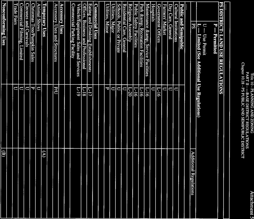
77 Title 10 - PLANNING AND ZONING PART II - BASE DISTRICT REGULATIONS Chapter PS PUBLIC AND SEMIPUBLIC DISTRICT Chapter PS PUBLIC AND SEMIPUBLIC DISTRICT Sections: Specific purposes Applicability Land use regulations Development regulations Specific purposes. In addition to the general purposes listed in Chapter 10.01, the specific purposes of the PS Public and Semipublic District are to: A. Allow consideration of a large public or semipublic use separately from regulations for an underlying base zoning that may or may not be appropriate in combination with the public or semipublic use. B. Allow consideration of establishment or expansion of a large public or semipublic use at rezoning hearings rather than at use permit hearings only, and give notice to all of the extent of a site approved for a large public or semipublic use by delineating it on the zoning map. C. Allow the Planning Commission and City Council to consider the most appropriate use of a site following discontinuance of a large public or semipublic use without the encumbrance of a base zoning district that may or may not provide appropriate regulations for reuse of the site. (Ord. No. 1832, Amended, 01/17/91; Ord. No. 1838, Renumbered, 07/05/91) Applicability. The regulations of the PS District shall preclude the regulations of any base district for the use classifications listed in Section , where these uses are permitted in the base district, and have a contiguous site area of 2 acres or more, including alleys, streets, or other rights-of-way. Public and semipublic use classifications on sites of less than 2 acres shall be subject to the regulations of the base and overlay districts in which they are located. (Ord. No. 1832, Amended, 01/17/91; Ord. No. 1838, Renumbered, 07/05/91; Ord. No. 1864, Amended, 02/18/93) Land use regulations. In the following schedule, the letter "P" designates use classifications permitted in PS districts. The letter "L" designates use classifications subject to certain limitations prescribed by the "Additional Use Regulations" which follow. The letter "U" designates use classifications permitted on approval of a use permit, as provided in Chapter The letters "P/U" for an accessory use mean that the use is permitted on the site of a permitted use but requires a use permit on the site of a conditional use. Page 1 of 4 Manhattan Beach, California, Code of Ordinances EXHIBIT D PC MTG
78 Title 10 - PLANNING AND ZONING PART II - BASE DISTRICT REGULATIONS Chapter PS PUBLIC AND SEMIPUBLIC DISTRICT Letters in parentheses in the "Additional Regulations" column reference regulations following the schedule.... PS DISTRICT: LAND USE REGULATIONS P Permitted U Use Permit L Limited (See Additional Use Regulations) PS... Public and Semipublic Cultural Institutions U Day Care, General U Farmers' Market U Government Offices L-16 Hospitals U Maintenance & Service L-16 Facilities Park & Recreation Facilities L-16 Public Safety Facilities L-16 Religious Assembly L-20 Residential Care, General U Schools, Public or Private U Utilities, Major U Utilities, Minor P Additional Regulations Commercial Uses Eating and Drinking Establishments L-17 Offices, Business and Professional L-18 Vehicle/Equipment Sales and L-19 Services Commercial Parking Facility Accessory Uses Accessory Uses and Structures Temporary Uses Animal Shows Christmas Tree/Pumpkin Sales Circuses and Carnivals Commercial Filming, Limited Trade Fairs Nonconforming Uses P/U U P U U U (A) (B) Page 2 of 4 Manhattan Beach, California, Code of Ordinances
79 Title 10 - PLANNING AND ZONING PART II - BASE DISTRICT REGULATIONS Chapter PS PUBLIC AND SEMIPUBLIC DISTRICT... PS District: Additional Use Regulations... L-16 City-owned facilities are permitted; all other facilities require a use permit. L-17 Permitted as an accessory use in a cultural, educational, hospital, or medical institution occupying no more than 5,000 square feet, only if there is no separate entrance or sign. L-18 Allowed on surplus school sites with a use permit subject to the following limitations: 1. No new structure, including temporary or mobile, shall be built or moved to the site for office purposes. 2. Adequate parking, or required by Chapter 10.64, shall be provided. 3. No clients or customers shall be permitted on the site except on an occasional basis. 4. Hours of business operation shall not exceed 7:00 a.m. to 7:00 p.m. and weekend and holiday use of the office facilities shall not be permitted except under specific time limitations established as a condition of approval of the use permit. 5. The Community Development Director shall review compliance with conditions of approval annually. 6. The permit may be revoked upon application of the property owner with six months notice to the office tenant. L-19 Public parking permitted, but commercial parking facilities on City-owned land require a use permit. L-20 A use permit is required, except for existing church facilities, including private schools contained therein, which do not exceed an overall floor area factor greater than half of the maximum floor area factor permitted by the development standards of the base district. Such excepted facilities shall be subject to the following standards: 1. The depth of the required front yard shall be the same as that required in the zone and area district in which it is located. 2. Buildings and structures on the site shall not be closer than 25 feet to any residential boundary property line, except that a detached single-family dwelling on such site shall conform to the yard requirements, height, and required distance between buildings as prescribed in the zone and area district in which the site is located. 3. No portion of any building or structure shall exceed a height of 30 feet as measured from the average of the finished ground level at the center of all walls, except that steeples or other architectural features containing no floor space may exceed such height limit. 4. All off-street parking requirements shall be conformed to, except that on interior lots the required side yards may be used to provide off-street parking areas and, on corner lots, the interior side yard may be similarly used. Under no circumstances may the required front yard Page 3 of 4 Manhattan Beach, California, Code of Ordinances
80 Title 10 - PLANNING AND ZONING PART II - BASE DISTRICT REGULATIONS Chapter PS PUBLIC AND SEMIPUBLIC DISTRICT or side yard on the side street side be used for off-street parking. 5. All lights provided to illuminate any parking area or building on such site shall be arranged so as to direct the light away from any premises upon which a dwelling unit is located. 6. All bounding streets and/or alleys shall be improved to the dimensions indicated on any formally-adopted plans therefor, and to the City's specifications pertaining to materials, design and construction. Where no official plan for street alignment or widths has been adopted, the plan shall be submitted to the Planning Commission for report and recommendation. 7. The following signs only are permitted: (i) One sign area on the outside wall of the main building and parallel thereto, having an area not greater than twenty (20) square feet; and (ii) A detached sign having dimensions totaling not more than twenty (20) square feet and on which both faces may be utilized, such sign being securely mounted on the ground on supports and the top of which sign shall not be more than six (6) feet above the natural level of the ground upon which it rests. 8. Loading and unloading of school buses shall be on the school site and no storage or servicing of school buses or automotive equipment shall be permitted on the site. (A) See Section : Temporary use permits. (B) See Chapter 10.68: Nonconforming uses and structures. (Ord. No. 1832, Amended, 01/17/91; Ord. No. 1838, Renumbered, 07/05/91, ; Ord. No. 1860, Amended, 10/29/92; Ord. No. 1864, Amended, 02/18/93; Ord. No. 1883, Amended, 07/15/93) Development regulations. Development regulations shall be as specified by the use permit, provided that if the use permit fails to regulate an element regulated by an abutting base district, or a use permit is not required, the regulations of the nearest base district shall apply to each portion of a PS district. (Ord. No. 1832, Amended, 01/17/91; Ord. No. 1838, Renumbered, 07/05/91) Page 4 of 4 Manhattan Beach, California, Code of Ordinances

 ti~ ~'~ ( )_Appeal to PCJPWC/BBA/CC ()Use Permit (Residential) QQ Coastal Development Permit (~j'use Pem~ (Cortimerciai) ( )Environmental Assessment ()Use Pemdt Amendment {")
 L) Lot MergedAdjusiment/S15 rec. fee (xj Subdivision (Lot Une Adjustment' ()Other ~f( OZ/z~/13 Fee Summary: Account No. 4225 (calculate fees on reverse) ~o.")
81 PION FORM BEACH DEPARTMENT Q~rce Only Qate Submitted: Received By: F&G Check Submitted: /-/z - /z- Legel Desuiption l'u-6lic Ga c, ~.f_~ ~S SPtiucr - P~GE<-v ~~ General Pfen DeslgnaUor~ Zoning Designation Area District ForprojecYS rsqulfi~y a Coastal0evebprr+ent Permit, select one of fhe following detemunafions': Pru~e~X t (~, Protect Qpj located to Agpeal Jwisdrdion " ~~ T 4 ed) Pubic Nearing Required (due W UP. Var., M nested) ~ ) ~~ ~~ ~ _,~ ~ 'No Public Hearing Required S QS.St mmo~ Sub e that apply) ti~ ~'~ ( )_Appeal to PCJPWC/BBA/CC ()Use Permit (Residential) QQ Coastal Development Permit (~j'use Pem~ (Cortimerciai) ( )Environmental Assessment ()Use Pemdt Amendment { ) Minar Exceptbn ()Variance ( )Subdivision (Map Deposit}4300 (j PuWk Notification Fee 1 t85 l )Subdivision (Tentative MaP) I I ParklFtec Quimby Fee 4425 l )Subdivision (Floe!) L) Lot MergedAdjusiment/S15 rec. fee (xj Subdivision (Lot Une Adjustment' ()Other ~f( OZ/z~/13 Fee Summary: Account No (calculate fees on reverse) ~o.~-~~ Pre-Application Confererx;a: Yes No Date: Fee: Amount Due: S (less Prig-Apppcallort Fee if submitted within past 3 months) Receipt Number. Date Paid: Cashier. Appllcant(s)/Appellant(s) Informatlon JASp~ i 1. K1P1 Name P.O. QaC~C l460 A~.NAM~124. CA gl$p2-1~}~,o Ma~Ting Address _~A CA(1NTY PRa.1~MA~,L4~a~tD~Pr ~ ~,11~ - G WORKv) Applicsnt(s~~4ppellant(sJ Relationship to PropeRy..1ASON L. Klr' (pita.l~ htim~acaf~i i~K: Confect Faison (lrx~de ratetlon to NappeBant) PJwr+e nium6er/eanai! 900 SouTM ~~r~wn~r Avg. s~ Buz ~w~+e~, ~ ~ ~eo3-i~3~ Complete Protect DescrlpUon- lncluding any demolition (attach additional pages if necessary) A~ A n1el,! 1../C3RARY. 0~/z~/t3 ' An Application for a Coastal DevefOpmeet PermR shall ba made r to. or concurrent with, en application for any other permit or approvals requk~ed for the project by the City of Manhattan Beech Munictpat Code. (Contlnued on rev+srse) EXHIBIT E PC MTG


82 STATE OF CALIFORNIA COUNTY OF LOS ANGELES QWNER'S AFFIDAVIT IMf9 ~1 1 LL.lRM T F~,,3,t,QKr~ being duly sworn, depose and say that I arturs ere the ownern of the property involved in t# is application and that the foregoing statemenffi and answers herein contained and the information herewith submitted are in all respecxs true and oy~rrec~~t~`~he best of myl~w know~ed9e end belief(. Signature of PropeRy Owner(s~{No?~wner in Escrow or Lessee} Print Name Mailing Address ya~~c. t R~7'n ~ r ~.~ l~k~ Tefephane Subscribed and sworn to before me, this~o (QT t day of Mttr~c~l, 201 in and for the County of ~..o q X-1 ti 6~ c ~ S State of to ANNA ELENA CEAVAKTE6 Commistlan ~I ~ Nowr wei+e - c~~ t, ~ ~a~~.e w~?012+ Notary Pub!!c f~~~ ~ 1 A 1 ~t~~f t t ~~~~ Hf ~~~~ ~N~~f~HH~~HH~1l1~~~~f~~~~ N~~f ~MN ~f~~ff ~M~MNf~1HH~~~N ~N~~~f~NM Fee Schedule Summary ~o ~~ Below are the fees typkaliy assodated wish the corresponding appligdans. Additional fees not shown on f1~is sheet may apply refer to current City Fee Resolutlon (contact the Planning Department for assistance.) Fees are subject to annual adjustment Firing Fee (public hearing no other discretionary approval required): $ 4,815 ~ Filing Fee (public hearing other discretlonary approvals required}: 1,660 ~ Flling Fee (no public hearing required administrative): 920 ~ Use PermR Use Permit Flung Fee: $ 5,200 ~ Master Use Permit FiNng Fee: 8,255 ~ Master Use Permit Amendment Filing Fee: 4,740 ~ Master Use Permit Convers(on: 4,075 ~ Varienc~e FUing Fee. g 5,160 ~ Minor Exaeptiorr Fling Fee (without notice}: $ 1,775 Filing Fee (wfth notice): 2,020 ~ Subdivisan CertNicate of Complfartce: ~ 1,560 Final Parcel AAap +mapping deposit: 515 Final Trad Map + rnapp{ng deposit 595 Mapping Deposit (paid witlti Flnal Map application): 500 Merger of Paroets or Lot Wye Adjustment 1,155 Ctuimby. (Parks 8 Recreation) fee.{per unit/lot): 1,817 Tentative Parcel Map (4 or less bts /units) No Public Hearing: 915 Tentethre Parcel Map (4 or lass bts /units) Public Hearing: 3,325 ~ Tentative Trail Map (5 or more~lots /units): 4,080 ~ Environmental!?eview (confect P/B»ning Division for epplicebla fee} Environmental Assessment (no Initial Study ~epared): S 215 Environmental Assessment (i(initisl Study is prepared): F'~sh and Game/CE(]A Exemption County C1er1c Posting Feet: 50 ~ Public Notiirca~n Fee applies to ail projects wiuti public hearings and $ B5 covers the aty's cosh of envelopes, postage arxi handling fhe mailing of public notices. Add this to filing fees above, as applicable: 'Make a separate X50 check payable to la County Clerk, (DO NOT PUT QATE ON CHECKI
III. PROJECT DESCRIPTION
 III. PROJECT DESCRIPTION LOCATION AND BOUNDARIES The City of Manhattan Beach is located in the South Bay region of Los Angeles County, California, approximately 2 miles south of the Los Angeles International
CITY OF MANHATTAN BEACH STAFF REPORT. THROUGH: Marisa Lundstedt, Director of Community Development
 CITY OF MANHATTAN BEACH STAFF REPORT TO: Planning Commission THROUGH: Marisa Lundstedt, Director of Community Development FROM: Tony Olmos, Director of Public Works DATE: April 29, 2015 SUBJECT: Determination
RESOLUTION NO. WHEREAS, the proposed Master Plan for Villa Esperanza (VE), located at 2116
, located at 2116") RESOLUTION NO. A RESOLUTION OF THE CITY COUNCIL OF THE CITY OF PASADENA APPROVING A MASTER PLAN FOR VILLA ESPERANZA WHEREAS, the proposed Master Plan for Villa Esperanza (VE), located at 2116 Villa Street
RESOLUTION NO. A RESOLUTION OF THE CITY COUNCIL OF THE CITY OF PASADENA APPROVING A MASTER PLAN FOR VILLA ESPERANZA WHEREAS, the proposed Master Plan for Villa Esperanza (VE), located at 2116 Villa Street
SPECIFIC PLAN Requirements
 CITY OF LANCASTER PLANNING DEPARTMENT 44933 Fern Avenue, Lancaster, California 93534 (661) 723-6100 SPECIFIC PLAN Requirements Purpose The purpose of a specific plan is to provide for the logical development
COMMERCIAL DESIGN REVIEW APPLICATION
 CITY OF LACEY Community Development Department 420 College Street Lacey, WA 98503 (360) 491-5642 COMMERCIAL DESIGN REVIEW APPLICATION OFFICIAL USE ONLY Case Number: Date Received: By: Related Case Numbers:
Design Review Commission Report
 City of Beverly Hills Planning Division 455 N. Rexford Drive Beverly Hills, CA 90210 TEL. (310) 285-1141 FAX. (310) 858-5966 Design Review Commission Report Meeting Date: Thursday, March 2, 2017 Subject:
STAFF REPORT TO THE CITY COUNCIL. Conduct Public Hearing to vacate certain public right of way adjacent to Sycamore Avenue and San Pablo Avenue
 STAFF REPORT TO THE CITY COUNCIL DATE: Adjourned Regular Meeting of December 16, 2014 TO: SUBMITTED BY: SUBJECT: Mayor and Members of the City Council Holly Smyth, Planning Director Conduct Public Hearing
Chapter Master Planned Communities (MPC) District
 District") Sections 14.53.010 Purpose and Intent 14.53.020 Applicability 14.53.030 Procedure 14.53.040 MPC Standards 14.53.050 Required Findings 14.53.010 Purpose and Intent Chapter 14.53 Master Planned Communities
Sections 14.53.010 Purpose and Intent 14.53.020 Applicability 14.53.030 Procedure 14.53.040 MPC Standards 14.53.050 Required Findings 14.53.010 Purpose and Intent Chapter 14.53 Master Planned Communities
ARLINGTON COUNTY, VIRGINIA
 ARLINGTON COUNTY, VIRGINIA County Board Agenda Item Meeting of April 23, 2019 DATE: April 12, 2019 SUBJECT: SP #413 SITE PLAN AMENDMENT to permit a fixed bar in a private outdoor café space with associated
PLANNED DEVELOPMENT (MASTER PLAN & UNIT PLAN)
") Central Permit Center 555 Santa Clara Street Vallejo CA 94590 Business License Building Fire Prevention Planning Public Works 707.648.4310 707.648.4374 707.648.4565 707.648.4326 707.651.7151 PLANNED DEVELOPMENT
Central Permit Center 555 Santa Clara Street Vallejo CA 94590 Business License Building Fire Prevention Planning Public Works 707.648.4310 707.648.4374 707.648.4565 707.648.4326 707.651.7151 PLANNED DEVELOPMENT
CITY OF VACAVILLE PLANNING COMMISSION Agenda Item No. G.3 STAFF REPORT August 18, 2015 Staff Contact: Peyman Behvand (707)
") CITY OF VACAVILLE PLANNING COMMISSION Agenda Item No. G.3 STAFF REPORT August 18, 2015 Staff Contact: Peyman Behvand (707) 449-5140 TITLE: REQUEST: VISTA CROSSINGS PLANNED SIGN PROGRAM AMENDMENT PLANNED
CITY OF VACAVILLE PLANNING COMMISSION Agenda Item No. G.3 STAFF REPORT August 18, 2015 Staff Contact: Peyman Behvand (707) 449-5140 TITLE: REQUEST: VISTA CROSSINGS PLANNED SIGN PROGRAM AMENDMENT PLANNED
DESIGN REVIEW COMMITTEE AGENDA ITEM
 DESIGN REVIEW COMMITTEE AGENDA ITEM AGENDA DATE: DECEMBER 16, 2015 TO: THRU: FROM: SUBJECT: Chair McCormick and Members of the Design Review Committee Leslie Aranda Roseberry, Planning Manager Kelly Christensen
Approved: CITY OF ARDEN HILLS, MINNESOTA PLANNING COMMISSION WEDNESDAY, AUGUST 5, :30 P.M. - ARDEN HILLS CITY HALL
 Approved: CITY OF ARDEN HILLS, MINNESOTA PLANNING COMMISSION WEDNESDAY, AUGUST 5, 2015 6:30 P.M. - ARDEN HILLS CITY HALL PLANNING CASES A. Planning Case 15-016; Final Planned Unit Development Arden Plaza;
COMMUNITY DESIGN. GOAL: Create livable and attractive communities. Intent
 COMMUNITY DESIGN Intent An attractive, well-designed County will attract quality development, instill civic pride, improve the visual character of the community, and create a strong, positive image for
PC RESOLUTION NO ARCHITECTURAL CONTROL (AC)
") PC RESOLUTION NO. 16-07-26- ARCHITECTURAL CONTROL (AC) 15-035 A RESOLUTION OF THE PLANNING COMMISSION OF THE CITY OF SAN JUAN CAPISTRANO, CALIFORNIA APPROVING ARCHITECTURAL CONTROL (AC) 15-035, INN AT
PC RESOLUTION NO. 16-07-26- ARCHITECTURAL CONTROL (AC) 15-035 A RESOLUTION OF THE PLANNING COMMISSION OF THE CITY OF SAN JUAN CAPISTRANO, CALIFORNIA APPROVING ARCHITECTURAL CONTROL (AC) 15-035, INN AT
Planning Commission Staff Report June 5, 2008
 Owner/Applicant Taylor Village Sacramento Investments Partners, LP c/o Kim Whitney 1792 Tribute Road #270 Sacramento, CA 95815 Staff Recommendation Planning Commission Staff Report Project: File: Request:
Design Review Application *Please call prior to submittal meeting to determine applicable fees*
 CITY OF EAGLE 660 E. Civic Lane, Eagle, ID 83616 Phone#: (208) 939-0227 Fax: (208) 938-3854 Design Review Application *Please call prior to submittal meeting to determine applicable fees* FILE NO.: CROSS
CITY OF ALAMEDA PLANNING BOARD Draft RESOLUTION
 CITY OF ALAMEDA PLANNING BOARD Draft RESOLUTION A RESOLUTION OF THE PLANNING BOARD OF THE CITY OF ALAMEDA APPROVING DESIGN REVIEW AND DEVELOPMENT PLAN AMENDMENT APPLICATION PLN13-0157 TO CONSTRUCT ELEVEN
R E S O L U T I O N. Single-Family Residence/ Church. 2,488 sq. ft. 2,488 sq. ft. Area Parking Required: Church
 R E S O L U T I O N WHEREAS, the Prince George s County Planning Board is charged with the approval of Detailed Site Plans pursuant to Part 3, Division 9 of the Zoning Ordinance of the Prince George s
A RESOLUTION OF THE PLANNING COMMISSION OF THE CITY
 RESOLUTION NO. A RESOLUTION OF THE PLANNING COMMISSION OF THE CITY OF SIGNAL HILL, CALIFORNIA, RECOMMENDING CITY COUNCIL ADOPTION OF ZONING ORDINANCE AMENDMENT 16-03, A REQUEST TO AMEND THE OFFICIAL ZONING
CITY OF KEIZER MASTER PLAN APPLICATION & INFORMATION SHEET
 CITY OF KEIZER MASTER PLAN APPLICATION & INFORMATION SHEET PRE-APPLICATION CONFERENCE Prior to the actual filing of a Master Plan application, it is strongly recommended that the applicant contact Planning
Venice Pumping Plant Dual Force Main Project Draft EIR
 City of Los Angeles 5.9 LAND USE PLANS 5.9.1 Environmental Setting Venice Pumping Plant Dual Force Main Project Draft EIR The Project lies within the bounds of Los Angeles County and the City of Los Angeles.
CITY OF VACAVILLE PLANNING COMMISSION Agenda Item No. G. 1 STAFF REPORT August 4, Staff Contact: Tricia Shortridge (707)
") CITY OF VACAVILLE PLANNING COMMISSION Agenda Item No. G. 1 STAFF REPORT August 4, 2009 Staff Contact: Tricia Shortridge (707) 449-5140 TITLE: REQUEST: LONGS / CVS DRIVE-THRU PHARMACY & REMODEL TIME EXTENSION
CITY OF VACAVILLE PLANNING COMMISSION Agenda Item No. G. 1 STAFF REPORT August 4, 2009 Staff Contact: Tricia Shortridge (707) 449-5140 TITLE: REQUEST: LONGS / CVS DRIVE-THRU PHARMACY & REMODEL TIME EXTENSION
ORDINANCE NO
 ATTACHMENT CC-1 ORDINANCE NO. 13-2113 AN ORDINANCE OF THE CUPERTINO CITY COUNCIL APPROVING THE REZONING OF AN APPROXIMATELY 1.1 ACRE AREA FROM PARK AND RECREATION (PR) TO PLANNED INDUSTRIAL PARK (P(MP))
Planning Commission Report
 Planning Commission Report To: From: Subject: Planning Commission Meeting: January 6, 2016 Agenda Item: 8-B Planning Commission David Martin, Planning & Community Development Director Introduction to the
CITY OF MERCER ISLAND DESIGN COMMISSION STAFF REPORT
 CITY OF MERCER ISLAND DESIGN COMMISSION STAFF REPORT Agenda Item: 2 March 9, 2011 Project: Description: Applicant: DSR11-004 The applicant is requesting approval to replace the existing exterior wood framed
The transportation system in a community is an
 7 TRANSPORTATION The transportation system in a community is an important factor contributing to the quality of life of the residents. Without a sound transportation system to bring both goods and patrons
ORDINANCE WHEREAS, this Ordinance is consistent with the City of Winter Garden Comprehensive Plan; and
 ORDINANCE 17-06 AN ORDINANCE OF THE CITY COMMISSION OF THE CITY OF WINTER GARDEN, FLORIDA, CREATING ARTICLE XIV OF CHAPTER 118 OF THE CITY OF WINTER GARDEN CODE OF ORDINANCES PROVIDING FOR THE EAST PLANT
Policies and Code Intent Sections Related to Town Center
 Policies and Code Intent Sections Related to Town Center The Town Center Vision is scattered throughout the Comprehensive Plan, development code and the 1994 Town Center Plan. What follows are sections
Future Five. Design/ Development Guidelines. January 2008 Amended June 08 per City Council motion
 Future Five Design/ Development Guidelines January 2008 Amended June 08 per City Council motion 5-Points Design Guidelines Table of Contents I. Introduction 3 II. Area boundaries 4 III. Review Process
REQUEST Current Zoning: O-15(CD) (office) Proposed Zoning: TOD-M(CD) (transit oriented development mixed-use, conditional)
 (office) Proposed Zoning: TOD-M(CD) (transit oriented development mixed-use, conditional)") Rezoning Petition 2016-117 Zoning Committee Recommendation January 4, 2017 REQUEST Current Zoning: O-15(CD) (office) Proposed Zoning: TOD-M(CD) (transit oriented development mixed-use, conditional) LOCATION
Rezoning Petition 2016-117 Zoning Committee Recommendation January 4, 2017 REQUEST Current Zoning: O-15(CD) (office) Proposed Zoning: TOD-M(CD) (transit oriented development mixed-use, conditional) LOCATION
CITY OF PERRIS COMMUNITY DEVELOPMENT DEPARTMENT PLANNING DIVISION FINAL CONDITIONS OF APPROVAL CITY COUNCIL
 CITY OF PERRIS COMMUNITY DEVELOPMENT DEPARTMENT PLANNING DIVISION FINAL CONDITIONS OF APPROVAL CITY COUNCIL TENTATIVE PARCEL MAP 34199 (05 0378), DEVELOPMENT PLAN REVIEW 05 0379, March 14, 2006 PROJECT:
GENERAL INFORMATIONaaaaaaaaaaaaaaaaaaaaaaaaaaaaaaaa
 To: Planning and Zoning Commission From: City Staff Date: November 15, 2016 Re: Case #16026 Raymore Activity Center Site Plan GENERAL INFORMATIONaaaaaaaaaaaaaaaaaaaaaaaaaaaaaaaa Applicant/ Property Owner:
Building & Site Design Standards Application
 FOR OFFICE USE ONLY Design standards plan review fee Building & Site Design Standards Application Phone: 208-468-5406 Fax: 208-468-5439 411 3rd Street South Nampa, Idaho 83651 5,000
CITY CLERK. Consolidated Clause in North York Community Council Report 8, which was considered by City Council on October 26, 27 and 28, 2004.
 CITY CLERK Consolidated Clause in Report 8, which was considered by City Council on October 26, 27 and 28, 2004. 28 Request for Direction Report - Site Plan Approval Application 03 200020 NNY 24 SA - Marek
MIXED-USE ZONING DISTRICT DESIGN GUIDELINES
 MIXED-USE ZONING DISTRICT DESIGN GUIDELINES In addition to the development regulations contained in the Mixed-Use Zoning District, design guidelines are presented here to provide an added level of definition
that the Town Board of the Town of East Greenbush will hold a public hearing on April 11,
 TOWN OF EAST GREENBUSH NOTICE OF PUBLIC HEARING PLEASE TAKE NOTICE that the Town Board of the Town of East Greenbush will hold a public hearing on April 11, 2018, at 5:45 p.m. at the East Greenbush Town
WEST LOOP DESIGN GUIDELINES CHECKLIST
 WEST LOOP DESIGN GUIDELINES CHECKLIST Section 1.0 General Strategies 1.1 DESIGN EXCELLENCE: ENCOURAGE HIGH QUALITY AND INNOVATIVE DESIGN OF NEW BUILDINGS WITHIN THE WEST LOOP WITHOUT BEING PRESCRIPTIVE
PLANNING COMMISSION. Submitted
 PLANNING COMMISSION City Hall 1275 Main Street El Centro, CA 92243 Submitted PLANNING COMMISSION ACTION ITEM (1844) Meeting: 05/10/16 12:00 AM Department: Community Development Category: Public Hearing
Glenborough at Easton Land Use Master Plan
 Implementation 114 9.0 IMPLEMENTATION 9.1 OVERVIEW This chapter summarizes the administrative procedures necessary to implement the proposed land use plan, infrastructure improvements, development standards,
ROLL CALL Member Anthony, Member Avdoulos, Member Greco, Member Lynch, Member Maday, Chair Pehrson
 CALL TO ORDER The meeting was called to order at 7:00 PM. PLANNING COMMISSION ACTION SUMMARY CITY OF NOVI Regular Meeting July 11, 2018 7:00 PM Council Chambers Novi Civic Center 45175 W. Ten Mile (248)
City Council Special Meeting AGENDA ITEM NO. C.
 City Council Special Meeting AGENDA ITEM NO. C. DATE: 01/04/2019 TO: Honorable Mayor and City Council Members SUBJECT: Transit Villages Specific Plan project Study Session (Development Services Director
DESIGN REVIEW COMMITTEE AGENDA ITEM
 DESIGN REVIEW COMMITTEE AGENDA ITEM AGENDA DATE: OCTOBER 17, 2012 TO: Chair Woollett and Members of the Design Review Committee THRU: FROM: SUBJECT: Leslie Aranda Roseberry, Planning Manager Daniel Ryan,
MONTGOMERY COUNTY PLANNING DEPARTMENT THE MARYLAND-NATIONAL CAPITAL PARK AND PLANNING COMMISSION
 MONTGOMERY COUNTY PLANNING DEPARTMENT THE MARYLAND-NATIONAL CAPITAL PARK AND PLANNING COMMISSION MCPB Item No. Date: 3.10.2016 Site Plan 820160040 Nora School Parker Smith, Planning Technician, Area 1,
DESIGN REVIEW COMMITTEE AGENDA ITEM
 DESIGN REVIEW COMMITTEE AGENDA ITEM AGENDA DATE: OCTOBER 3, 2012 TO: Chair Woollett and Members of the Design Review Committee THRU: FROM: SUBJECT: Leslie Aranda Roseberry, Planning Manager Daniel Ryan,
ARTICLE 17 SITE PLAN REVIEW
 ARTICLE 17 SITE PLAN REVIEW 17.01 INTENT AND PURPOSE The intent of this section is to provide for consultation and cooperation between the applicant and the township planning commission so that the applicant
Harmony Technology Park Third Filing, Second Replat Custom Blending, Project Development Plan/Final Development Plan - FDP #130021
 ITEM NO FDP #130021 MEETING DATE July 23, 2013 STAFF Pete Wray ADMINISTRATIVE TYPE I HEARING STAFF REPORT PROJECT: APPLICANT: OWNER: Harmony Technology Park Third Filing, Second Replat Custom Blending,
City of Hermosa Beach Administrative Policy #
 City of Hermosa Beach Administrative Policy # SUBJECT: Living Streets Policy Date: Approved by: City Council Authority: Public Works Department & Community Development Department Mayor, PURPOSE The City
CITY OF VAUGHAN EXTRACT FROM COUNCIL MEETING MINUTES OF MAY 27, 2014
 CITY OF VAUGHAN EXTRACT FROM COUNCIL MEETING MINUTES OF MAY 27, 2014 Item 6, Report No. 21, of the Committee of the Whole, which was adopted without amendment by the Council of the City of Vaughan on May
Design Review Application
 Design Review Application OFFICIAL USE ONLY File Number: Date Received: By: Pre-Application Fee Paid: Design Review Fee Paid: Approved Date: Denied Date: By: ADRE: Yes No APPLICANT INFORMATION Project
CITY OF MANHATTAN BEACH DEPARTMENT OF COMMUNITY DEVELOPMENT. TO: Parking and Public Improvements Commission
 Clay Curtin, Management Analyst (I the same walls at a maximum of 1 foot tall. Section 7.36.150 of the Municipal Code permits BY: Eric Haaland, Associate Planner right-of-way) between walkways leading
Prepared by: Casey Kempenaar, Senior Planner
 CITY OF CITRUS HEIGHTS PLANNING DIVISION STAFF REPORT PLANNING COMMISSION MEETING September 13, 2017 Prepared by: Casey Kempenaar, Senior Planner REQUEST The applicant requests a Design Review Permit Modification
ARLINGTON COUNTY, VIRGINIA
 ARLINGTON COUNTY, VIRGINIA County Board Agenda Item Meeting of September 19, 2015 DATE: September 11, 2015 SUBJECTS: Outdoor Café at Citizen Burger Bar A. SP# 418 Site Plan Amendment to modify an approved
RESOLUTION NO: WHEREAS, the subject property has a Public, Semi-Public (PS) zoning designation and a General Plan designation of Institutional; and
 zoning designation and a General Plan designation of Institutional; and") RESOLUTION NO: A RESOLUTION OF THE CITY COUNCIL OF THE CITY OF PASADENA APPROVING A 14-YEAR, EIGHT-PHASE MASTER PLAN AMENDMENT FOR HUNTINGTON MEMORIAL HOSPITAL LOCATED AT 100 WEST CALIFORNIA BOULEVARD
RESOLUTION NO: A RESOLUTION OF THE CITY COUNCIL OF THE CITY OF PASADENA APPROVING A 14-YEAR, EIGHT-PHASE MASTER PLAN AMENDMENT FOR HUNTINGTON MEMORIAL HOSPITAL LOCATED AT 100 WEST CALIFORNIA BOULEVARD
ARLINGTON COUNTY, VIRGINIA
 ARLINGTON COUNTY, VIRGINIA County Board Agenda Item Meeting of July 21, 2012 DATE: July 12, 2012 SUBJECT: SP #416 SITE PLAN AMENDMENT to modify condition #6 to eliminate requirement to provide a pedestrian
Project phasing plan (if applicable) 12 copies of site plan
 12 copies of site plan") SITE PLAN REVIEW PERMIT APPLICATION City of Grand Haven, 11 N. Sixth Street, Grand Haven, MI 49417 Phone: (616) 847-3490 Fax: (616) 844-2051 Website: www.grandhaven.org 1. Project Information Address/location
SITE PLAN REVIEW PERMIT APPLICATION City of Grand Haven, 11 N. Sixth Street, Grand Haven, MI 49417 Phone: (616) 847-3490 Fax: (616) 844-2051 Website: www.grandhaven.org 1. Project Information Address/location
Improve Neighborhood Design and Reduce Non Point Source Water Pollution
 HOW TO Planning Guide Improve Neighborhood Design and Reduce Non Point Source Water Pollution This document was funded by a grant from the New Hampshire Coastal Program with funding from the National Oceanic
McDonald s Restaurant - Purcellville Town of Purcellville Special Use Permit Statement of Justification July 24, 2014
 Introduction / Written Statement McDonald s Restaurant - Purcellville McDonald s Corporation is proposing to redevelop the existing McDonald s eating establishment with a drive-through located at 121 N
5.1.1 The streetscape along US Highway 64 (Brevard Road); and, The built environment within new residential developments; and,
; and, The built environment within new residential developments; and,") Article 5. Landscaping 5.1 Purpose The Town of Laurel Park s landscape standards are designed to create a beautiful, aesthetically pleasing built environment that will complement and enhance community
Article 5. Landscaping 5.1 Purpose The Town of Laurel Park s landscape standards are designed to create a beautiful, aesthetically pleasing built environment that will complement and enhance community
Mayor Leon Skip Beeler and Members of the City Commission. Anthony Caravella, AICP, Director of Development Services
 CITY COMMISSION BRIEFING & Planning Board Report For Meeting Scheduled for June 7, 2012 Inner Room Cabaret Site Plan/Architectural Review Downtown Overlay District/Primary Downtown Area Site Plan Consent
RESOLUTION NO. R Refining the route, profile and stations for the Downtown Redmond Link Extension
 RESOLUTION NO. R2018-32 Refining the route, profile and stations for the Downtown Redmond Link Extension MEETING: DATE: TYPE OF ACTION: STAFF CONTACT: Capital Committee Board PROPOSED ACTION 09/13/2018
TREASURE COAST REGIONAL PLANNING COUNCIL M E M O R A N D U M. To: Council Members AGENDA ITEM 5H
 TREASURE COAST REGIONAL PLANNING COUNCIL M E M O R A N D U M To: Council Members AGENDA ITEM 5H From: Date: Subject: Staff October 17, 2008 Council Meeting Local Government Comprehensive Plan Review Draft
MIDTOWN MIXED-USE VILLAGE. TECHNICAL DATA SHEET COMPONENT C-1 FOR PUBLIC HEARING - PETITION NUMBER Project No RZ1.1. Issued.
 N MIDTOWN MIXED-USE VILLAGE TECHNICAL DATA SHEET COMPONENT C- FOR PUBLIC HEARING - PETITION NUMBER 04-00 Project No. 496 Issued Revised SCALE: " = 0' N 0 0 0 40 RZ. c GENERAL PROVISIONS: a. SITE LOCATION.
SUBCHAPTER 4-B GUIDELINES FOR THE B-3 COMMERCIAL CHARACTER AREA
 1 SUBCHAPTER 4-B GUIDELINES FOR THE B-3 COMMERCIAL CHARACTER AREA Downtown Bozeman should be the location of buildings of greatest height and intensity in the community. The following guidelines apply
MEMORANDUM. TERESA McCLISH, COMMUNITY DEVELOPMENT DIRECTOR
 MEMORANDUM TO: FROM: BY: CITY COUNCIL TERESA McCLISH, COMMUNITY DEVELOPMENT DIRECTOR KELLY HEFFERNON, ASSOCIATE PLANNER SUBJECT: CONSIDERATION OF ADOPTION OF AN ORDINANCE AMENDING CHAPTER 16.84 OF THE
REPORT TO MAYOR AND COUNCIL
 REPORT TO MAYOR AND COUNCIL AGENDA ITEM NO. 5.a TO THE HONORABLE MAYOR AND COUNCIL: DATE: May 26, 2015 SUBJECT: ADOPT RESOLUTION NOS. 15-33, 15-34, 15-35, AND 15-36, CONFIRMING THE ASSESSMENT DIAGRAMS
APPLICATION FOR REZONING PROPERTY CITY OF HOLLAND, MICHIGAN. Name of Applicant. Address, and Phone # of Applicant
 APPLICATION FOR REZONING PROPERTY CITY OF HOLLAND, MICHIGAN Name of Applicant Address, Email and Phone # of Applicant Name and Address of Owner (if other than applicant) Ownership Interest of Applicant
Planned Development Review Revisions (Project No. PLNPCM )
") Planned Development Review Revisions (Project No. PLNPCM2014-00139) Standard residential development Planned Development Example: Smaller lot sizes than what is allowed to create open space amenity. What
Planned Development Review Revisions (Project No. PLNPCM2014-00139) Standard residential development Planned Development Example: Smaller lot sizes than what is allowed to create open space amenity. What
AMEND DMENT H HOSPITAL
 AMEND DMENT TO LAND USE PLAN ELEMENT VILLAGE OF RIDGEWOOD MASTER PLAN H HOSPITAL ZONE DISTRICT Village of Ridgewood Planning Board February 28, 2014with technical revisions from June 9, 2014 Planning Board
SUBMITTAL REQUIREMENTS
 WHEN PROCESS TYPE III IS USED References to Process Type III applications are found in several places in the Milton Municipal Code (MMC), indicating that the development, activity, or use, is permitted
PUBLIC RIGHT-OF-WAY IN THIS CHAPTER PUBLIC REALM
 PUBLIC RIGHT-OF-WAY This section provides design guidelines for improvements in the public right-of-way. The public right-of-way refers to streets, sidewalks, non-vehicular thoroughfares, parks and greenways
TO: CITY COUNCIL DATE: MARCH 23,2009
 Report TO: CITY COUNCIL DATE: MARCH 23,2009 FROM: CITY MANAGER SUBJECT: MASTER DEVELOPMENT PLAN AMENDMENT FOR PASADENA CHRISTIAN SCHOOL AT 1515 NORTH LOS ROBLES AVENUE AND GENERAL PLAN AMENDMENT AND ZONE
Application for Site Plan Review
 Application for Site Plan Review City of Pontiac Office of Land Use and Strategic Planning 47450 Woodward Ave, Pontiac, MI 48342 T: 248.758.2800 F: 248.758.2827 Property/Project Address: Sidwell Number:
Community Design Plan
 Gardena General Plan 2006 Authority While the is not a required element of a General Plan, it is included because improving the community appearance and image is paramount to the overall quality of life
DRAFT. 10% Common Open Space
 % OF CHARLOTTE IS CATEGORIZED AS A. LAND USES : Placeholder map displaying location of Place Type GOALS: Accommodate XX% of future growth. Provide a concentration of primarily commercial and civic activity
CHAPTER ADDITIONAL REQUIREMENTS IN THE NC, NEIGHBORHOOD COMMERCIAL ZONE
 CITY OF MOSES LAKE MUNICIPAL CODE CHAPTER 18.31 ADDITIONAL REQUIREMENTS IN THE NC, NEIGHBORHOOD COMMERCIAL ZONE Sections: 18.31.010 Purpose 18.31.020 Minimum Lot Area 18.31.030 Setbacks 18.31.040 Maximum
VILLAGE OF SKOKIE Design Guidelines for Mixed-Use Districts NX Neighborhood Mixed-Use TX Transit Mixed-Use CX Core Mixed-Use
 VILLAGE OF SKOKIE Design Guidelines for Mixed-Use Districts NX Neighborhood Mixed-Use TX Transit Mixed-Use CX Core Mixed-Use TABLE OF CONTENTS CHAPTER 1 SITE DESIGN Purpose 1 CHAPTER 2 SITE DESIGN Streetscape
WHEREAS, after consideration of the evidence presented at the public hearing on January 14, 2010, the Prince George's County Planning Board finds:
 R E S O L U T I O N WHEREAS, the Prince George s County Planning Board has reviewed DDS-600 requesting a departure for the location of two loading spaces without driveway access along Toledo Terrace in
Incentive Zoning Regulations Florida Municipal City of Orlando
 Topic: Resource Type: State: Jurisdiction Type: Municipality: Year (adopted, written, etc.): 2002 Community Type applicable to: Title: Incentive Zoning Regulations Florida Municipal City of Orlando Document
B. Blocks, Buildings and Street Networks
 B. Blocks, Buildings and Street Networks Figure IV.4 A rational block pattern with connected streets Introduction The single most important element in the physical and functional integration of mixed use
D1 September 11, 2013 Public Hearing APPLICANT:
 D1 September 11, 2013 Public Hearing APPLICANT: BEACH MUNICIPAL FEDERAL CREDIT UNION PROPERTY OWNER: SISTERS II, LLC STAFF PLANNER: Karen Prochilo REQUEST: Conditional Change of Zoning (AG-2 Agriculture
Honorable Mayor and Members of the City Council. Submitted by: Eric Angstadt, Director, Planning and Development
 Office of the City Manager ACTION CALENDAR January 29, 2013 To: From: Honorable Mayor and Members of the City Council Christine Daniel, City Manager Submitted by: Eric Angstadt, Director, Planning and
The West Vaughan Employment Area Secondary Plan Policies
 Part 2: The West Vaughan Employment Area Secondary Plan Policies 2.1 General Policies It is the policy of Council: 2.1.1. That the West Vaughan Employment Area (the WVEA), identified on Schedule 1, will
The Illinois Department of Transportation and Lake County Division of Transportation. Route 173, including the Millburn Bypass
 The Illinois Department of Transportation and Lake County Division of Transportation welcome you to this Public Hearing for U.S. Route 45 from Illinois Route 132 to Illinois Route 173, including the Millburn
Watertown City Council
 City of Watertown Watertown City Council April 14 th, 2015 Agenda Item: City Comment on Sun Share CUP Application Request for Action: Motion to Approve City Comments regarding CUP Application Department:
ZONING ORDINANCE FOR THE ZONED UNINCORPORATED AREAS ARTICLE 1150 OF PUTNAM COUNTY, WEST VIRGINIA Page 95 ARTICLE 1150 SITE PLAN REVIEW
 OF PUTNAM COUNTY, WEST VIRGINIA Page 95 1150.01 PURPOSE 1150.02 APPLICABILITY 1150.03 APPLICATION PROCESS 1150.04 REVIEW PROCESS 1150.05 REVIEW CRITERIA 1150.06 SITE PLAN GUIDELINES 1150.01 PURPOSE ARTICLE
SDOT DPD. SDOT Director s Rule DPD Director s Rule DCLU DR SED DR of 7 CITY OF SEATTLE
 SDOT SDOT Director s Rule 2-07 DPD Applicant: CITY OF SEATTLE Page 1 of 7 Supersedes: DCLU DR 11-93 SED DR 93-4 Seattle Department of Transportation (SDOT) Department of Planning and Development (DPD)
Joint Study Session of the Sutter County. March 2, 2009
 Joint Study Session of the Sutter County Board of Supervisors and Planning Commission March 2, 2009 CURRENT APPLICATION General Plan Amendment Specific Plan Specific Plan Appendices Utility Plans Transit/AQ
AWH REPORT OF THE PLANNING AND DEVELOPMENT DEPARTMENT FOR APPLICATION FOR REZONING ORDINANCE TO PLANNED UNIT DEVELOPMENT
 AWH REPORT OF THE PLANNING AND DEVELOPMENT DEPARTMENT FOR APPLICATION FOR REZONING ORDINANCE TO PLANNED UNIT DEVELOPMENT MAY 8, 2014 The Planning and Development Department hereby forwards to the Planning
NOTICE OF SPECIAL MEETING
 NOTICE OF SPECIAL MEETING Pursuant to Section 54956 of the Government Code of the State of California, a Special meeting of the Tracy City Council is hereby called for: Date/Time: Location: Tuesday, April
ATTACHMENT A. SILVERDALE DESIGN STANDARDS Amendments to the Waaga Way Town Center Chapter
 ATTACHMENT A SILVERDALE DESIGN STANDARDS Amendments to the Waaga Way Town Center Chapter Chapter 10. Waaga Way Town Center 10.1 Physical Identity Elements & Opportunities The Waaga Way Town Center includes
IMPACT ON FINANCIAL AND PERSONNEL RESOURCES:
 MEMORANDUM TO: FROM: CITY COUNCIL GEOFF ENGLISH, PUBLIC WORKS DIRECTOR SUBJECT: CONSIDERATION OF ADOPTION OF RESOLUTIONS ORDERING THE PREPARATION AND FILING OF ANNUAL ENGINEER S REPORTS FOR THE PARKSIDE
City of Reedley Community Development Department 1733 Ninth Street Reedley, CA (559) FAX
 FAX") City of Reedley SPECIAL PERMIT Submittal Requirements Conditional Use Permit (CUP), Site Plan Review (SPR) & Variance (VAR) Please use this information sheet as a checklist to assemble materials required
City of Reedley SPECIAL PERMIT Submittal Requirements Conditional Use Permit (CUP), Site Plan Review (SPR) & Variance (VAR) Please use this information sheet as a checklist to assemble materials required
FLORIN ROAD CORRIDOR Site Plan and Design Review Guidelines Checklist
 FLORIN ROAD CORRIDOR Site Plan and Design Review Guidelines Checklist Applicant s Name: Project Address: Phone: Email: Applicant shall fill out the design guidelines checklist for all guidelines applicable
P.C. RESOLUTION NO
 P.C. RESOLUTION NO. 08-423 A RESOLUTION OF THE PLANNING COMMISSION OF THE CITY OF CALABASAS TO ADOPT A SIGN PROGRAM (PL0800543) AND APPROVE A VARIANCE (PL0800544) FOR INTERNAL ILLUMINATION OF THE MERCEDES-BENZ
CITY OF CYPRESS 5275 Orange Avenue Cypress, California (714) DESIGN REVIEW COMMITTEE PERMIT PROCESS
 DESIGN REVIEW COMMITTEE PERMIT PROCESS") CITY OF CYPRESS 5275 Orange Avenue Cypress, California 90630 (714) 229-6720 DESIGN REVIEW COMMITTEE PERMIT PROCESS 1. Discuss project with Planning staff to determine zoning regulations, any unusual characteristics
CITY OF CYPRESS 5275 Orange Avenue Cypress, California 90630 (714) 229-6720 DESIGN REVIEW COMMITTEE PERMIT PROCESS 1. Discuss project with Planning staff to determine zoning regulations, any unusual characteristics
City of Yelm. Tahoma Terra Final Master Plan Development Guidelines. Table of Contents
 City of Yelm Tahoma Terra Final Master Plan Development Guidelines Table of Contents Table of Contents... 1 Purpose... 2 Low Density Residential (R4-6)... 3 Moderate Density Residential (R6-10)... 5 Neighborhood
MINUTES OF THE TOWN COUNCIL MEETING SEPTEMBER 1, 2016
 MINUTES OF THE TOWN COUNCIL MEETING SEPTEMBER 1, 2016 Town Council Meeting 09/20/16 Item #1 The Town Council of the Town of Los Gatos conducted a Special Meeting on Thursday, September 1, 2016, at 6:00
PC RESOLUTION NO GRADING PLAN MODIFICATION (GPM)
") PC RESOLUTION NO. 16-07-26- GRADING PLAN MODIFICATION (GPM) 16-006 A RESOLUTION OF THE PLANNING COMMISSION OF THE CITY OF SAN JUAN CAPISTRANO, CALIFORNIA APPROVING GRADING PLAN MODIFICATION (GPM) 16-006,
PC RESOLUTION NO. 16-07-26- GRADING PLAN MODIFICATION (GPM) 16-006 A RESOLUTION OF THE PLANNING COMMISSION OF THE CITY OF SAN JUAN CAPISTRANO, CALIFORNIA APPROVING GRADING PLAN MODIFICATION (GPM) 16-006,
The full agenda including staff reports and supporting materials are available at City Hall.
 Date: February 28, 2018 Time: 6:00 p.m. Place: City Council Chambers 350 North Valencia Blvd. Woodlake, CA 93286 In compliance with the Americans with Disabilities Act and the California Ralph M. Brown