The City of Carlsbad Planning Division A REPORT TO THE PLANNING COMMISSION
|
|
|
- Dominic Brooks
- 5 years ago
- Views:
Transcription
1
2
3
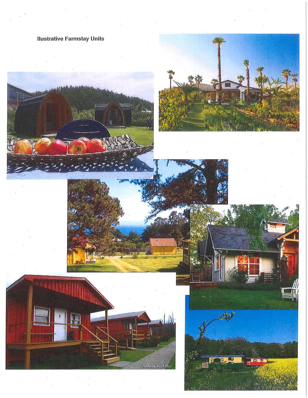
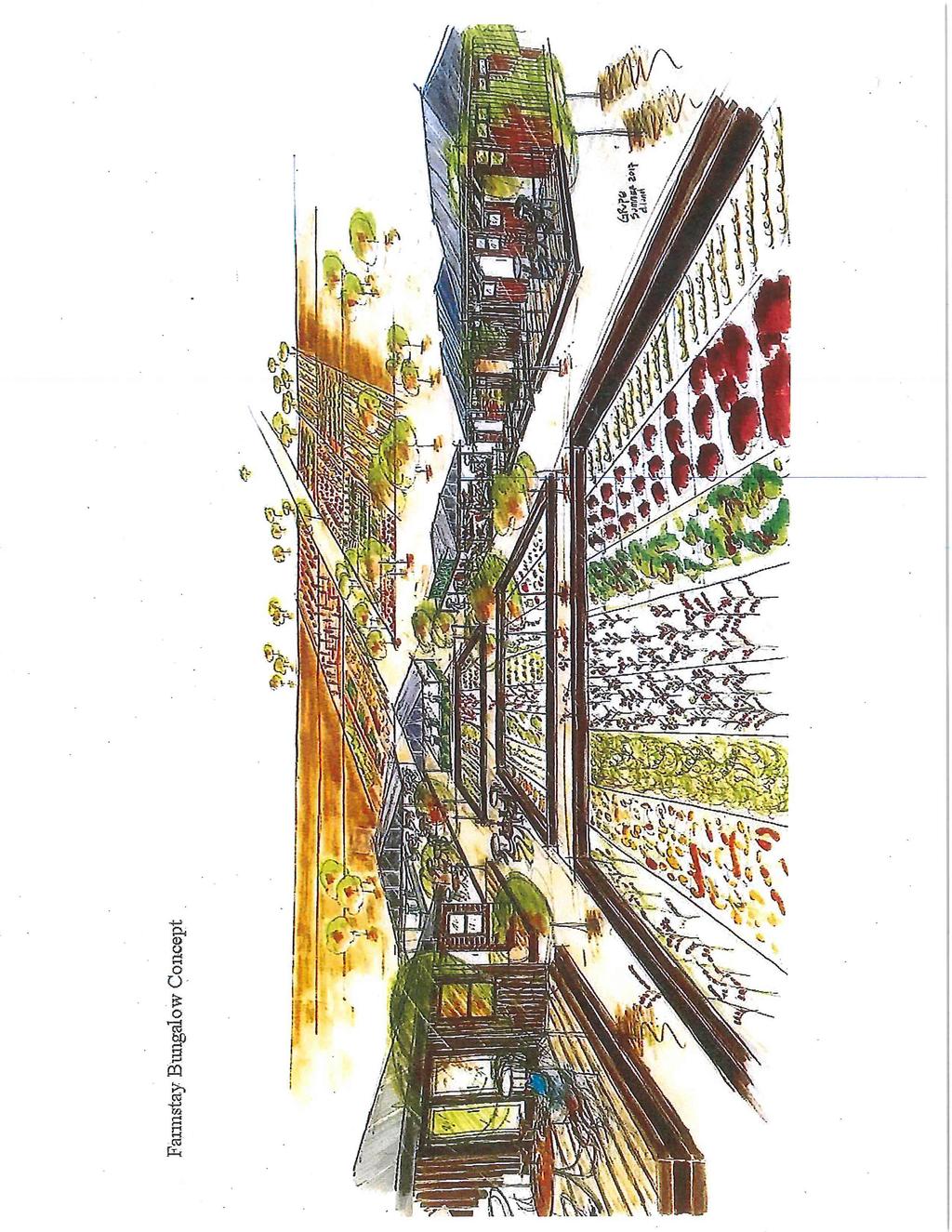
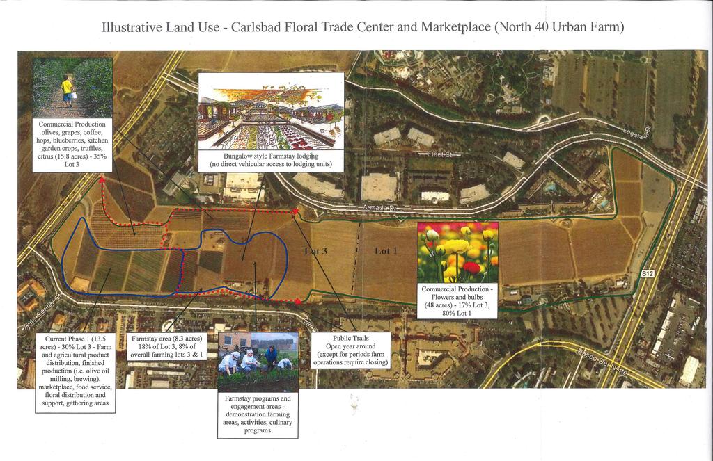
4 The City of Carlsbad Planning Division A REPORT TO THE PLANNING COMMISSION Item No. 4 Application complete date: N/A P.C. AGENDA OF: December 6, 2017 Project Planner: Carl Stiehl Project Engineer: David Rick SUBJECT: PCD (DEV ) FARM STAY LODGING IN CR-A/OS ZONE DETERMINATION Request for a Planning Commission Determination (PCD) that farm stay lodging may be permitted as a secondary agricultural use in the Cannon Road Agricultural/Open Space (CR-A/OS) zone. The request for a determination from the Planning Commission is not subject to CEQA. I. RECOMMENDATION That the Planning Commission ADOPT Planning Commission Resolution No RECOMMENDING DENIAL of PCD , based on the findings contained therein. II. PROJECT DESCRIPTION AND BACKGROUND The project is a request by the Carltas Company (applicant) for a determination that farm stay lodging may be permitted as a secondary agricultural use in the CR-A/OS zone. The CR-A/OS zone applies to two parcels (see Attachment 5), which have been used for agriculture. The applicant owns one of the two parcels, which is approximately 45 acres south of Cannon Road on the east side of Car Country Drive (currently referred to as North 40 Urban Farm ; previously known as Floral Trade Center and Market Place ). The second parcel in the CR-A/OS zone is approximately 26 acres south of Cannon Road on the east side of Legoland Drive. Both properties in the CR-A/OS zone are designated by the General Plan as Open Space (OS) and are subject to Proposition D (Preserve the Flower and Strawberry Fields and Save the Carlsbad Taxpayers Money). The applicant s requested determination would apply to all properties within the CR-A/OS zone, not just the property owned by the applicant. In regard to the applicant s property, in addition to agricultural production, the city has approved development of other primary and secondary agricultural uses consisting of a floral trade center, sale of agricultural products grown on site and agricultural related manufacturing (culinary center, microbrewery and winery). The applicant is also considering the potential of developing farm stay lodging on a portion of the site (8.3 acres), which is the reason for this PCD request. This PCD request is made pursuant to Zoning Ordinance Sections B and C; Section reads as follows (Table A of Section is omitted here; see Attachment 2 for a complete copy of Zoning Ordinance Chapter ): Permitted primary and secondary uses A. In the CR-A/OS zone, notwithstanding any other provisions of this title, only the uses listed in Table A, below, shall be permitted. B. Uses similar to those listed in Table A may be permitted if the City Planner determines such similar use falls within the intent and purpose of this zone.
5 PCD (DEV ) FARM STAY LODGING IN CR-A/OS ZONE DETERMINATION December 6, 2017 Page 2 C. Other uses that are not listed in Table A, and which cannot be found to be similar to those uses listed in Table A, may be recommended for approval as a permitted use to the Planning Commission provided that the City Planner ascertains all pertinent facts and the Planning Commission, by resolution of record, sets forth its findings and its interpretations that the use is substantially consistent with the intent and purpose and guiding principles (Sections and ) of this zone. Such Planning Commission resolution shall be forwarded to the City Council as a recommendation and, if approved by resolution of the City Council, thereafter such interpretation shall govern. An LCP amendment may be required for any change or addition to permitted uses. D. The establishment and continuation of agricultural uses in the zone is encouraged for as long as the land owners determine that it is economically viable. When agriculture is no longer economically viable for the landowners, only the other open space uses listed in Table A shall be permitted. Pursuant to Zoning Ordinance Section B, the applicant requests that farm stay lodging be considered similar to the secondary agricultural uses listed as permitted in Table A of Section If the Planning Commission does not determine that farm stay lodging is similar to the uses listed in Table A of Section , then the applicant requests the Planning Commission determine and recommend to the City Council that the use be permitted in the zone, pursuant to Section C. Staff recommends denial of the requested determinations. As stated in Attachment 4, the applicant also requests confirmation that all uses included on Table A (both agriculture and open space) are permitted while agricultural production continues on the property. Staff has not included this portion of the applicant s request as part of PCD , as it is a general request that the Zoning Ordinance does not specify that the Planning Commission needs to make a determination regarding. A response to this portion of the request is provided in the analysis section below. III. ANALYSIS A. Analysis of PCD The following analysis addresses each determination requested by PCD : Is farm stay lodging a use that is similar to the uses permitted in the Cannon Road Agricultural/Open Space (CR-A/OS) zone? If the Planning Commission determines that farm stay lodging is not similar to the uses listed in Table A of Section , the commission may recommend that the use be permitted in the zone by finding that the use is substantially consistent with the intent, purpose and guiding principles of the CR-A/OS zone. 1. Is farm stay lodging a use that is similar to the uses permitted in the Cannon Road Agricultural/Open Space (CR-A/OS) zone? As stated in Attachment 4, the applicant describes farm stay lodging as a related and accessory use to the primary agriculture use of the applicant s land, and is a lodging concept that utilizes the aesthetic of a farm environment and the relationship with the production of food or floral crops as a vehicle to underwrite the cost of providing the environment.
6 PCD (DEV ) FARM STAY LODGING IN CR-A/OS ZONE DETERMINATION December 6, 2017 Page 3 Table A of Section (Attachment 2) specifies the uses that are permitted as primary and secondary agricultural uses. Farm stay lodging is not a primary agricultural use, per Table A of Section ; as requested by the applicant, the question is whether or not the use is similar to the secondary agricultural uses listed in Table A of Section , which are as follows: TABLE A SECONDARY AGRICULTURAL USES PERMITTED IN THE CR-A/OS ZONE Secondary Agricultural Uses Permitted Minor CUP CUP City Planner Planning Commission 1 Agricultural distribution facilities X Other accessory or related uses that promote the 2 continuation of a primary permitted agricultural use, as determined by the City Planner X Public/private events and activities (permanent or temporary) related to promoting a primary 3 permitted agricultural use (examples: X demonstrations, seasonal sales/temporary sales, special events, tours) 4 Retail sales of agricultural crops and related products limited to a cumulative area of 1,000 square feet or less (examples: on-premise sale of crops to the public, produce store, "you pick" operations, sale of products made from crops) X Retail sales of agricultural crops and related products with a cumulative area of more than 5 1,000 square feet (examples: on-premise sale of crops to the public, produce store, "you pick" operations, sale of products made from crops) X A lodging use is not similar to the uses in rows 1, 3, 4 and 5 above (agricultural distribution facilities, events and activities related to agriculture, and retail sales of agricultural products). The use identified in row 2 above (accessory or related uses that promote continuation of a primary agricultural use) is the use that the applicant proposes is similar to farm stay lodging. The applicant s rationale is that farm stay lodging is designed to provide overnight guests with a farm environment (related to the agriculture) and the revenue from the lodging use will promote the continuation of agriculture. While farm stay lodging may promote the continuation of agriculture on the site by providing a supplemental revenue source, farm stay lodging is neither an agricultural use nor an open space use, which is the primary reason the City Planner could not find it to be similar to the permitted uses listed in Table A. The uses in Table A are categorized as either agricultural or open space uses. The secondary agricultural uses listed in Table A, as shown above, are secondary agricultural uses (i.e. uses that occur during or after agricultural production distribution of the agricultural product, retail sale of the agricultural product, and events/activities that promote the sale of agricultural products). These secondary agricultural uses would not occur without an existing primary agricultural use. The secondary agricultural use identified in row 2 above (accessory or related uses that promote continuation of a primary agricultural use) is not intended to allow uses that are not agricultural in nature; this is why Table A refers to the uses as secondary agricultural uses.
7 PCD (DEV ) FARM STAY LODGING IN CR-A/OS ZONE DETERMINATION December 6, 2017 Page 4 Based on the information above, the City Planner has determined that farm stay lodging is not similar to the uses listed in Table A of Section The following summarizes the requested Planning Commission determination and options: The applicant is requesting that the Planning Commission determine that farm stay lodging is similar to the uses listed in Table A of Section If the Planning Commission determines that the use is similar to the uses listed in Table A, then the commission must determine that farm stay lodging is consistent with the intent and purpose of the CR-A/OS zone (see discussion below for information on the intent and purpose of the zone). If the Planning Commission determines that farm stay lodging is not similar to the uses listed in Table A, the applicant requests that the Planning Commission recommend the use be permitted in the CR-A/OS zone, pursuant to Section C (see below). 2. If the Planning Commission determines that farm stay lodging is not similar to the uses listed in Table A of Section , the commission may recommend that the use be permitted in the zone by finding that the use is substantially consistent with the intent, purpose and guiding principles of the CR-A/OS zone. The following information evaluates how farm stay lodging is or is not substantially consistent with the intent, purpose and guiding principles of the CR-A/OS zone. a. Intent and Purpose of the CR-A/OS Zone As stated in Zoning Ordinance Section (Attachment 2), the intent and purpose of the CR-A/OZ zone is to: TABLE B INTENT AND PURPOSE OF THE CR-A/OS ZONE 1) Implement Proposition D, the "Preserve the Flower and Strawberry Fields and Save Taxpayers Money" proposition enacted by the voters of Carlsbad in November 2006; 2) Promote and support the continuation of agriculture in the zone for as long as the land owners determine that it is economically viable to do so; 3) Protect, encourage, and enhance public uses, public access, public views/vantage points, and community gathering places; 4) Ensure that all uses in the zone address traffic, circulation and transportation impacts; 5) Provide for agricultural and other active, passive and cultural open space uses that provide economic benefit to the land owners as set forth in Table A of this chapter; 6) Create a sustainable area with agricultural and open space uses that balance social, economic and environmental values important to the community; 7) Provide for community input on the design of proposed development and uses; 8) Protect areas of existing natural habitat in conformance with the city s habitat management plan and local coastal program; 9) Implement the goals and objectives of the General Plan. In particular, the goals and objectives related to the Cannon Road Open Space, Farming and Public Use Corridor.
8 PCD (DEV ) FARM STAY LODGING IN CR-A/OS ZONE DETERMINATION December 6, 2017 Page 5 Staff has determined that a lodging use, even one that uses the farm environment as a theme, is not substantially consistent with at least two of the intent and purpose statements listed above. Specifically, a lodging use is inconsistent with the purpose of Proposition D and the policies of the General Plan, as follows: i. Proposition D TABLE C PURPOSE OF PROPOSITION D 2.1 Purpose. The purpose of this measure is to ensure that the Flower Fields and Strawberry Fields area located along the Cannon Road corridor east of the Interstate 5 freeway is preserved in open space and that farming is allowed to continue as long as it is viable. The purpose is also to allow public use, access and community gathering places to occur in the area in a manner that will not adversely impact the unique open space and environmental resources located in the area. This measure is intended to create a sustainable area that balances social, economic and environmental values important to the community. This measure amends the General Plan which contains the vision for the future of the City and the Zoning Ordinance to designate the area for special planning consideration to ensure that the area is retained in open space, that farming is allowed to continue and that public uses and access are allowed in the area. Proposition D (Attachment 3) clearly states that the purpose is to ensure the Cannon Road corridor is preserved in open space. Agriculture is allowed to continue; however, the proposition recognizes that agriculture, at some point, may no longer be economically viable, and therefore, the proposition identifies that if the land is not farmed, then it shall be retained in open space. A lodging use is not an agricultural use or an open space use, and therefore is not substantially consistent with the purpose statement of Proposition D. In addition, the permanent nature of a newly-constructed lodging use may hinder the ability for the site to transition to open space if agriculture becomes no longer viable. The purpose of the proposition was incorporated into the General Plan through specified language in The Cannon Road Open Space, Farming and Public Use Corridor. ii. General Plan General Plan policies 2-P.62 through 2-P.68 directly reflect the language of Proposition D. A lodging use is not substantially consistent with policies 2-P.62 and 2-P.63, which read as follows: TABLE C GENERAL PLAN POLICIES 2-P.62 In coordination with land owners, protect and preserve this area as an open space corridor. Permit only open space, farming and compatible public uses in the area. Permitted uses shall be as follows: a. Open space. b. Farming and other related agricultural support uses, including flower and strawberry production. c. Public trails. d. Active and passive parks, recreation and similar public and private use facilities (except on the existing Flower Fields). e. Electrical transmission facilities. 2-P.63 Prohibit residential development in the area; and prohibit commercial and industrial-type uses in the area other than those normally associated with or in support of farming operations and open space uses.
9 PCD (DEV ) FARM STAY LODGING IN CR-A/OS ZONE DETERMINATION December 6, 2017 Page 6 Policy 2-P.62 states that the only uses that are to be permitted within the Cannon Road open space corridor are open space, farming and compatible public uses. A lodging use is not an open space, farming or public use; it is a commercial use. The applicant requests that farm stay lodging be considered an agricultural support use (which is listed in the policy as one of the uses that can be permitted), because the lodging use would provide financial support to the agricultural use. Staff s interpretation of policy 2- P.62 is that because the policy clearly states that ONLY open space, farming and compatible public uses are permitted, then related agricultural support uses would need to be considered an open space, farming or compatible public use. In addition, policy 2-P.63 states that commercial uses are prohibited, unless they are normally associated with or in support of farming and open space uses. While a lodging use may support the agricultural use financially, it is not a use that is normally associated with or normally in support of a farming or open space use. When considering whether or not a lodging use could be considered a commercial use that is normally associated with a farming use, it is important to consider what the community intended when they approved Proposition D. Following approval of Proposition D, a comprehensive community engagement process overseen by a citizen s liaison committee was conducted, pursuant to the proposition, to determine the most appropriate uses to be permitted in the Cannon Road open space corridor. As stated in the committee s final report to the City Council, the committee identified that if more commercial-types of uses related to agriculture were allowed on the lands, it would assist the property owners and farmers in continuing to make agriculture more economically viable. While this statement could be interpreted broadly, the committee identified what those commercial uses could consist of, keeping in mind that Proposition D prohibits commercial uses unless they are normally associated with an open space, farming or compatible public use. The committee determined the following secondary agricultural uses, which include some commercial uses, would be appropriate: Agricultural distribution facilities. Public events and activities promoting agriculture (examples: tours, demonstrations, special events). Retail sales of agricultural crops and related products (examples: on premise sale of crops to the public, produce store, sale of products made from crops). A lodging use is not substantially consistent with the commercial uses the citizens committee determined would be appropriate in support of an agricultural use. In an effort to show that farm stay lodging is normally associated with farming uses, the applicant has provided examples of farm stay lodging that exist in other locations. Although farm stay lodging may exist in other areas that does not indicate that lodging is a normal part of farming operations, as intended by Proposition D. It is likely that the examples of farm stay lodging are located in areas where the local land use regulations permit the use. Staff s interpretation of the land use regulations applicable to the CR- A/OS zone is that a lodging use is not permitted by Proposition D, the General Plan or the CR-A/OS zone. Based on the analysis above, staff concludes that a lodging use, even one that uses the farm environment as a theme, is not substantially consistent with the purpose of Proposition D or the General Plan policies that pertain to the CR-A/OS zone; and therefore, farm stay lodging is not substantially consistent with the intent and purpose of the CR-A/OS zone.
10 PCD (DEV ) FARM STAY LODGING IN CR-A/OS ZONE DETERMINATION December 6, 2017 Page 7 b. Guiding Principles of the CR-A/OS Zone As stated in Zoning Ordinance Section (see Attachment 2), the guiding principles of the CR- A/OS zone are intended to guide the planning of development and establishment of uses in the zone to create a sustainable area that balances social, economic and environmental values that are important to the community. All proposed development, uses, or grouping of uses shall be reviewed for conformance with the applicable guiding principles. The guiding principles are as follows: TABLE C GUIDING PRINCIPLES OF THE CR-A/OS ZONE Social Principles Economic Principles Environmental Principles a) Encourage open space uses that have a strong community orientation and that provide maximum opportunities for people to gather, interact and socialize. b) Create an area that is unique, vibrant and exciting by providing a diversity of open space uses. c) Integrate art, culture and history into the agricultural and open space uses permitted in the zone. a) Recognize that the zone consists of privately owned lands and that community desires for certain open space uses depend on economic feasibility and benefit to the property owners. b) Support uses that economically benefit the continuation of agriculture in the zone, including organic farming, community farming and other innovative or mixed-use agricultural operations. a) Balance natural open space uses with improved or developed public uses. b) Protect and preserve existing natural habitats and encourage the restoration of disturbed areas of habitat. c) Provide safe walking and biking through trails and pathways that interconnect uses and sites in the zone and surrounding area, which maximize public access to, and preserve and enhance, ocean and lagoon views. i. Social Principles The social principles of the CR-A/OS zone focus on creating a publicly accessible area that is comprised of open space uses, as well as art, culture and history. Lodging may be designed to provide opportunities for the public to gather, interact and socialize, but as described in the principles above, such opportunities are intended to be provided through open space uses, not commercial uses. A lodging use, which is a commercial use, is not an open space, art, culture or history use, and therefore is not substantially consistent with these social principles. ii. Economic Principles As stated above, a lodging use may provide a revenue source that could promote the continuation of agriculture, which could be interpreted as consistent with the economic principle to support uses that economically benefit the continuation of agriculture. However, an evaluation of these economic principles must be viewed within the context of the overall intent and purpose of the zone. As stated above, the intent and purpose of the zone, through implementation of Proposition D and the General Plan, limits the uses permitted in the zone to ONLY open space, farming and compatible public uses. Therefore, the city may support uses that economically benefit the continuation of agriculture, provided such uses are open space, farming or compatible public uses. A lodging use is not substantially consistent with the uses intended to be supported by these economic principles.
11 PCD (DEV ) FARM STAY LODGING IN CR-A/OS ZONE DETERMINATION December 6, 2017 Page 8 iii. Environmental Principles As stated above, evaluation of these principles must be viewed within the context of the overall intent and purpose of the zone. A lodging use is not substantially consistent with the principle to balance open space and public uses. The intent and purpose of the zone is to permit only open space, farming and compatible public uses. This limited menu of permitted uses is an important component of implementing the zone s environmental principles, particularly the ability to achieve a balance of open space and public uses. The principle is not to achieve a balance of open space, public uses and commercial uses. A lodging use is not substantially consistent with the environmental principle to achieve a balance of open space with public uses. Based on the analysis above, staff concludes that a lodging use, even one that uses the farm environment as a theme, is not substantially consistent with the guiding principles of the CR-A/OS zone. B. Response to additional applicant request The following responds to the applicant s request for an interpretation regarding the permitted uses identified in Table A of Zoning Ordinance Section As stated in Section II of this report, the applicant requests confirmation that all uses included on Table A (both agriculture and open space) are permitted while agricultural production continues on the property. Staff has not included this portion of the applicant s request as part of PCD , as it is a general request that the Zoning Ordinance does not specify that the Planning Commission needs to make a determination regarding. The response to the request is as follows: While agriculture production continues on property within the CR-A/OS zone, all uses listed in Table A of Section (agricultural and open space uses) may be permitted on such properties, subject to all applicable policies and regulations. Any conversion of agricultural uses to non-agricultural uses (i.e., a permitted open space use per Table A of Section ) is subject to the city s agricultural conversion requirements specified in Zoning Ordinance Chapter C. Next steps 1. If the Planning Commission agrees the staff recommendation that farm stay lodging is not similar to uses permitted by Table A of Section and that farm stay lodging is not substantially consistent with the intent, purpose and guiding principles of the CR-A/OS zone, then: a. Planning Commission can adopt the attached resolution recommending denial of PCD If the Planning Commission determines pursuant to Section B that farm stay lodging is similar to uses permitted by Table A of Section and that the use is consistent with the intent and purpose of the CR-A/OS zone, then: a. Planning Commission can direct staff to return with a resolution determining that farm stay lodging is similar to uses permitted by Table A of Section and finding that the use is consistent with the intent and purpose of the CR-A/OS zone. After commission adoption of this resolution, farm stay lodging would be considered a permitted use in the zone.
12 PCD (DEV ) FARM STAY LODGING IN CR-A/OS ZONE DETERMINATION December 6, 2017 Page 9 3. If the Planning Commission determines that farm stay lodging is not similar to uses permitted by Table A of Section , but determines that farm stay lodging is substantially consistent with the intent, purpose and guiding principles of the CR-A/OS zone pursuant to Section C, then: a. Planning Commission can direct staff to return with a resolution finding that farm stay lodging is substantially consistent with the intent, purpose and guiding principles of the CR-A/OS zone and recommending to the City Council that farm stay lodging be permitted in the CR-A/OS zone. b. This option may require an amendment to the Zoning Ordinance and Local Coastal Program. Section C states that a Local Coastal Program amendment may be required for any change or addition to permitted uses. Staff would consult with Coastal Commission staff to determine if allowing farm stay lodging as a permitted use, if it is not considered similar to the other permitted uses, would require a Local Coastal Program amendment. IV. ENVIRONMENTAL REVIEW The City Planner has determined that PCD is exempt from CEQA. CEQA Guidelines Section 15270, Projects Which Are Disapproved, states that CEQA does not apply to projects which a public agency rejects or disapproves. This section is intended to allow an initial screening of projects on the merits for quick disapprovals prior to the initiation of the CEQA process where the agency can determine that the project cannot be approved. This Planning Commission determination, regarding whether or not a particular use is similar to other permitted uses or whether or not a use is consistent with the intent and purpose of zoning regulations, which is recommended for denial is that type of project. Upon a final determination on PCD , a Notice of Exemption will be filed by the City Planner. Development of any permitted uses or uses determined to be permitted, per Zoning Ordinance Sections B and C, will be subject future environmental review pursuant to CEQA. ATTACHMENTS: 1. Planning Commission Resolution No Cannon Road Agricultural/Open Space Zone, Zoning Ordinance Chapter Prop D, Preserve the Flower and Strawberry Fields and Save the Carlsbad Taxpayers Money 4. Applicant s Request Letter 5. Prop D and CR-A/OS Zone Area Map
13 ATTACHMENT A RESOLUTION OF THE PLANNING COMMISSION OF THE CITY OF CARLSBAD, CALIFORNIA, RECOMMENDING DENIAL OF A REQUEST FOR A DETERMINATION THAT FARM STAY LODGING MAY BE PERMITTED AS A SECONDARY AGRICULTURAL USE IN THE CANNON ROAD AGRICULTURAL/OPEN SPACE (CR-A/OS) ZONE. CASE NAME: FARM STAY LODGING IN CR-A/OS ZONE DETERMINATION CASE NO: PCD (DEV ) WHEREAS, the Carltas Company, L.P. has filed a verified application with the City of Carlsbad for a Planning Commission Determination regarding farm stay lodging in the C-A/OS Zone; and WHEREAS, a use not listed in Table A of Zoning Ordinance Section may be determined to be permitted in the CR-A/OS Zone, pursuant to Sections B and C; and WHEREAS, the Planning Commission did on December 6, 2017, hold a duly noticed public hearing as prescribed by law to consider said request for a Planning Commission determination; and WHEREAS, at said public hearing, upon hearing and considering all testimony and arguments, if any, of all persons desiring to be heard, the Planning Commission considered all factors relating to the requested Planning Commission Determination (PCD ). as follows: Findings: PLANNING COMMISSION RESOLUTION NO NOW, THEREFORE, BE IT HEREBY RESOLVED by the Planning Commission of the City of Carlsbad A. The foregoing recitations are true and correct. B. Based on the evidence presented at the public hearing, the Planning Commission RECOMMENDS DENIAL of PCD FARM STAY LODGING IN CR-A/OS ZONE DETERMINATION, based on the following findings: 1. Pursuant to Zoning Ordinance Section B, farm stay lodging is not similar to the uses listed in Table A of Section , because: A. The uses permitted by Table A are either agricultural uses or open space uses. This limited list of uses directly implements Proposition D "Preserve the Flower and Strawberry Fields and Save Taxpayers Money" and General Plan Policy 2-P.62, which state that only open space, farming and compatible public uses shall be permitted. B. Interpretation of whether or not a use is similar to the uses permitted by Table A, is limited to the uses that Proposition D and the General Plan specify as permitted, which are open space, agricultural and compatible public uses. C. Farm stay lodging is a commercial use that is not considered an open space, agricultural or compatible public use, and therefore is not similar to the uses permitted by Table A of Section
14 Pursuant to Zoning Ordinance Section C, farm stay lodging is not substantially consistent with the intent and purpose of the Cannon Road Agricultural/Open Space (CR-A/OS) zone, because: A. The intent and purpose of the CR-A/OS Zone is to implement Proposition D "Preserve the Flower and Strawberry Fields and Save Taxpayers Money. The purpose of Proposition D is to ensure that if land within the Cannon Road corridor is not being used for farming then the land must be preserved in open space. Farm stay lodging is not a farming use or an open space use, and therefore is not substantially consistent with the purpose of Proposition D and thereby is not substantially consistent with the intent and purpose of the CR-A/OS Zone. B. The intent and purpose of the CR-A/OS Zone is to implement the General Plan. Based on the following, farm stay lodging is not substantially consistent with General Plan Policies 2-P.62 and 2-P.63 and thereby is not substantially consistent with the intent and purpose of the CR- A/OS Zone. i. General Plan Policy 2-P.62 states that only open space, farming and compatible public uses are permitted in the Cannon Road Open Space, Farming and Public Use Corridor; the policy also lists farming and other related agricultural support uses as a use that is permitted. Because the policy clearly states that only open space, farming and compatible public uses are permitted, then related agricultural support uses would need to be considered an open space, farming or compatible public use. Although farm stay lodging may provide financial support to an agricultural use, it is not substantially consistent with General Plan Policy 2-P.62 because it is not an open space, farming or compatible public use ii. General Plan Policy 2-P.63 states that commercial uses are prohibited unless the commercial use is normally associated with or in support of farming operations and open space uses. A lodging use, in the context of the purpose of Proposition D, is not considered a commercial use that is normally associated with farming operations. In the Proposition D citizens liaison committee s final report, dated September 23, 2008, the committee identified the types of commercial uses that would the appropriate in support of farming operations; those uses were limited to retail sale of agricultural crops and related products (such as on premise sale of crops, produce store, sale of products made from crops). The sale of agricultural products is considered a secondary agricultural use (a secondary integral part of the farming operation the sale of the crop). A lodging use is not an agricultural use and is not an integral part of a farming operation. Therefore, farm stay lodging is not substantially consistent with General Plan Policy 2-P Pursuant to Zoning Ordinance Section C, farm stay lodging is not substantially consistent with guiding principles of the Cannon Road Agricultural/Open Space (CR-A/OS) zone, because: A. The social principles of the CR-A/OS zone focus solely on creating a publicly accessible area that is comprised of open space uses, as well as art, culture and history. Lodging may be designed to provide opportunities for the public to gather, interact and socialize, but as described in the social principles of the CR-A/OS Zone, such opportunities are intended to be provided through open space uses, not commercial uses. A lodging use, which is a commercial use, is not an open space, art, culture or history use, and therefore is not substantially consistent the social principles of the CR-A/OS Zone. PC RESO NO
15 B. The economic principles of the CR-A/OS Zone support uses that economically benefit the continuation of agriculture. Farm stay lodging, as a revenue source may economically benefit the continuation of agriculture. However, within the context of the intent and purpose of the CR-A/OS Zone, through implementation of Proposition D and the General Plan, the uses permitted in the zone are limited to only open space, farming and compatible public uses. Therefore, support of uses that economically benefit the continuation of agriculture is limited to uses that are open space, farming or compatible public uses. A lodging use is not substantially consistent with the uses intended to be supported by the economic principles of the CR-A/OS Zone. C. An environmental principle of the CR-A/OS Zone is to balance natural open space uses with public uses. Farm stay lodging is a commercial uses that is not substantially consistent with the principle to balance open space uses and public uses PC RESO NO
16 PASSED, APPROVED, AND ADOPTED at a regular meeting of the Planning Commission of the City of Carlsbad, held on December 6, 2017, by the following vote, to wit: AYES: NOES: ABSENT: ABSTAIN: JEFF SEGALL, Chairperson CARLSBAD PLANNING COMMISSION ATTEST: DON NEU City Planner PC RESO NO
17 ATTACHMENT 2 Chapter CR-A/OS CANNON ROAD AGRICULTURAL/OPEN SPACE ZONE Sections: Intent and purpose Definitions Guiding principles for permitted uses Permitted primary and secondary uses Conditional use permit requirement Site development plan requirement Pre-submittal community input process Development and design standards Severability Intent and purpose. A. The intent and purpose of the Cannon Road Agricultural/Open Space (CR-A/OS) zone is to: 1. Implement Proposition D, the Preserve the Flower and Strawberry Fields and Save Taxpayers Money proposition enacted by the voters of Carlsbad in November Promote and support the continuation of agriculture in the zone for as long as the landowners determine that it is economically viable to do so; 3. Protect, encourage, and enhance public uses, public access, public views/vantage points, and community gathering places; 4. Ensure that all uses in the zone address traffic, circulation and transportation impacts; 5. Provide for agricultural and other active, passive, and cultural open space uses in the zone that provide economic benefit to the landowners as set forth in Table A of this chapter; 6. Create a sustainable area, which means an area that contains agricultural and open space uses that balance social, economic, and environmental values important to the community; 7. Provide for community input on the design of proposed development and uses; 8. Protect areas of existing natural habitat in conformance with the city s habitat management plan and local coastal program; and 9. Implement the goals and objectives of the general plan. In particular, the goals and objectives related to the Cannon Road Open Space, Farming and Public use Corridor Definitions. A. Whenever the following terms are used in this chapter, they shall have the following meaning established by this section: 1. Primary use means a use that is not required to be developed in conjunction with or on the same site, lot, or parcel of land as another permitted and/or secondary use. 2. Secondary use means a use that is permitted only if developed in conjunction with and/or in support of at least one primary use Guiding principles. A. The following principles, as set forth below, are intended to guide the planning of development and establishment of uses in the zone to create a sustainable area that balances social, economic and environmental values that are important to the community. All proposed development, uses, or grouping of uses shall be reviewed for conformance with the applicable guiding principles.
18 1. Social principles. a. Encourage open space uses that have a strong community orientation and that provide maximum opportunities for people to gather, interact, and socialize. b. Create an area that is unique, vibrant and exciting by providing a diversity of open space uses. c. Integrate art, culture and history into the agricultural and open space uses permitted in the zone. 2. Economic principles. a. Recognize that the zone consists of privately owned lands and that community desires for certain open space uses depend on economic feasibility and benefit to the property owners. b. Support uses that economically benefit the continuation of agriculture in the zone, including organic farming, community farming, and other innovative or mixed-use agricultural operations. 3. Environmental principles. a. Balance natural open space uses with improved or developed public uses. b. Protect and preserve existing natural habitats and encourage the restoration of disturbed areas of habitat. c. Provide safe walking and biking through trails and pathways that interconnect uses and sites in the zone and surrounding area, which maximize public access to, and preserve and enhance, ocean and lagoon views Permitted primary and secondary uses. A. In the CR-A/OS zone, notwithstanding any other provisions of this title, only the uses listed in Table A, below, shall be permitted. B. Uses similar to those listed in Table A may be permitted if the City Planner determines such similar use falls within the intent and purpose of this zone. C. Other uses that are not listed in Table A, and which cannot be found to be similar to those uses listed in Table A, may be recommended for approval as a permitted use to the Planning Commission provided that the City Planner ascertains all pertinent facts and the Planning Commission, by resolution of record, sets forth its findings and its interpretations that the use is substantially consistent with the intent and purpose and guiding principles (Sections and ) of this zone. Such Planning Commission resolution shall be forwarded to the City Council as a recommendation and, if approved by resolution of the City Council, thereafter such interpretation shall govern. An LCP amendment may be required for any change or addition to permitted uses. D. The establishment and continuation of agricultural uses in the zone is encouraged for as long as the land owners determine that it is economically viable. When agriculture is no longer economically viable for the landowners, only the other open space uses listed in Table A shall be permitted. TABLE A PERMITTED USES In the table, below, subject to all applicable permitting and development requirements of the municipal code: P indicates that the use is permitted. CUP indicates use is permitted with approval of a conditional use permit. 1 = Administrative hearing process. 2 = Planning Commission process.
19 Agricultural Uses Primary Agricultural Uses P CUP Agricultural crop production (wholesale) (Including floriculture and horticulture, and structures necessary for production, maintenance, harvesting, storage and distribution functions associated with directly X supporting the on-site primary agricultural crop production use.) Agricultural-related educational, research and development facilities 1 Community farming (example: individual citizens or community groups growing agricultural crops.) X Agricultural farm worker housing (see note 1 below) X Energy transmission and distribution facilities, including but not limited to rights-ofway and pressure control or booster stations, substations, gas metering/regulating stations or operating centers for gasoline, electricity, natural gas, synthetic natural X gas, oil or other forms of energy sources, with the necessary accessory equipment incidental thereto. Farmers market (sale of primarily agricultural products) 1 Floral trade center (wholesale or retail) 2 Greenhouses X Plant nurseries and supplies (retail) 1 Tree and seed growing farms X Utility buildings/facilities that are built, operated, or maintained by a public utility to the extent that they are regulated by the California Public Utilities Commission. X Vineyards and wineries X Secondary Agricultural Uses P CUP Agricultural distribution facilities 2 Other accessory or related uses that promote the continuation of a primary permitted agricultural use, as determined by the City Planner. 1 Public/private events and activities (permanent or temporary) related to promoting a primary permitted agricultural use (examples: demonstrations, seasonal X sales/temporary sales, special events, tours). (see note 2 below) Retail sales of agricultural crops and related products limited to a cumulative area of 1,000 square feet or less (examples: on-premise sale of crops to the public, produce store, you pick X operations, sale of products made from crops.) Retail sales of agricultural crops and related products with a cumulative area of more than 1,000 square feet (examples: on-premise sale of crops to the public, produce store, you pick 1 operations, sale of products made from crops.) Open Space Uses Primary Open Space Uses P CUP Amphitheater 2 Civic and public gathering spaces (examples: art display, gazebos, public plazas, sitting areas, water features, wedding X areas) Community meeting center 1 Dog park 1 Energy transmission and distribution facilities, including but not limited to rights-ofway and pressure control or booster stations, substations, gas metering/regulating X
20 stations or operating centers for gasoline, electricity, natural gas, synthetic natural gas, oil or other forms of energy sources, with the necessary accessory equipment incidental thereto. Gardens (public or private) (examples: botanical, rose, tea, and meditation gardens) Habitat preserves and natural areas X Historic center 1 Agricultural or natural history related museum 1 Parks (public or private) 1 Picnic areas 1 Sports or recreation center (public outdoor) (examples: athletic courts and fields, lawn bowling, swimming pools, tennis courts) Trails (examples: bicycle, exercise, equestrian, nature, pedestrian) Utility buildings/facilities that are built, operated, or maintained by a public utility to the extent that they are regulated by the California Public Utilities Commission. Secondary Open Space Uses P CUP Food service, including restaurants and cafes, limited to a cumulative area of 500 square feet or less. X Food service, including restaurants and cafes with a cumulative area of more than 500 square feet. 1 Other accessory or related uses that promote the continuation of a primary permitted open space use. 1 Public/private events and activities (permanent or temporary) related to promoting a primary permitted open space use (examples: demonstrations, seasonal sales/temporary sales, special events, tours) X (see note 2 below) Retail sales of goods and products, related to a primary permitted open space use, limited to a cumulative area of 500 square feet or less. X Retail sales of goods and products, related to a primary permitted open space use, with a cumulative area of more than 500 square feet. 2 Notes: 1. Agricultural farm worker housing consisting of no more than 36 beds in group quarters or 12 units or spaces designed for use by a single family or household is permitted in accordance with California Health and Safety Code Section Subject to Special Events (Chapter 8.17 of this Code), Minor Special Events on Private Property and/or Temporary Sales Location permits as appropriate Conditional use permit requirement. A. Decision-making process. The conditionally permitted primary and secondary uses, as indicated in Table A, shall be processed in accordance with the applicable provisions of Chapter (Minor Conditional Use Permits and Conditional Use Permits) of this title and the requisite findings therein. B. Finding of fact. In addition to the findings for approving a minor conditional use permit or a conditional use permit as set out in Chapter 21.42, a finding shall be made that: 1. The proposed use or grouping of uses implements the intent and purpose of the Cannon Road Agricultural/Open Space (CR-A/OS) zone as set forth in Section of this chapter. X X 1 2
21 2. The proposed use or grouping of uses conforms to the applicable guiding principles contained in Section of this chapter. 3. The proposed development complies with the applicable development and design standards contained in Section of this chapter. 4. Feasible and appropriate public art, public access, and civic and public gathering space elements have been incorporated into the design of the proposed development Site development plan requirement. A. A site development plan shall be required for development in the zone as noted below. 1. Exemptions. The following types of development are exempt from the requirement for a minor site development plan or site development plan: a. Structures associated with primary or secondary agricultural uses which include: i. Structures containing a cumulative area of 2,000 square feet or less. ii. Greenhouses or plant protection (shade, wind, etc.) structures containing a cumulative area of 10,000 square feet or less. iii. Temporary or seasonal plant protection (shade, wind, etc.) structures. Temporary or seasonal as used herein shall mean a structure that is in place for no more than 180 days in any 12 month period. iv. Open shade structures (gazebo, trellis, patio cover, etc.) containing a cumulative area of 1,000 square feet or less. b. Structures associated with primary or secondary open space uses which include: i. Structures containing a cumulative area of 1,000 square feet or less. ii. Open shade structures containing a cumulative area of 1,000 square feet or less. 2. Minor Site Development Plan. A minor site development plan shall be required for the following: a. Structures associated with primary or secondary agricultural uses which include: i. Structures containing a cumulative area of more than 2,000 square feet and up to 10,000 square feet. ii. Greenhouses or plant protection structures containing a cumulative area of more than 10,000 square feet and up to 50,000 square feet. b. Structures associated with primary or secondary open space uses which include: i. Structures containing a cumulative area of more than 1,000 square feet and up to 5,000 square feet. ii. Open shade structures containing a cumulative area of more than 1,000 square feet and up to 5,000 square feet. 3. Site Development Plan. A site development plan shall be required for, but not limited to, the following: a. Structures associated with primary or secondary agricultural uses which include: i. Structures containing a cumulative area of more than 10,000 square feet. ii. Greenhouses or shade structures containing a cumulative area of more than 50,000 square feet. b. Structures associated with primary or secondary open space uses which include: i. Structures containing a cumulative area of more than 5,000 square feet. ii. Open shade structures containing a cumulative area of more than 5,000 square feet.
22 B. Decision-making process. 1. A minor site development plan shall be processed in accordance with the applicable provisions of Section (C) and Chapter (Q-Qualified Development Overlay Zone) of this title, including the requisite findings therein. The City Planner shall be the decision maker for a minor site development plan required by this chapter. 2. A site development plan shall be processed in accordance with the applicable provisions of Section (C) and Chapter (Q-Qualified Development Overlay Zone) of this title, including the requisite findings therein. The Planning Commission shall be the decision maker for a site development plan required by this chapter. C. Findings of fact. In addition to the findings for approving a minor site development plan or site development plan as set out in Chapter 21.06, findings shall be made that: 1. The proposed development implements the intent and purpose of the Cannon Road Agricultural/Open Space (CR-A/OS) zone as set forth in Section of this chapter. 2. The proposed development conforms to the applicable guiding principles contained in Section of this chapter. 3. The proposed development complies with the applicable development and design standards contained in Section of this chapter. 4. Feasible and appropriate public art, public access, and civic and public gathering space elements have been incorporated into the design of the proposed development Pre-submittal community input process. A. Prior to the submittal of a minor site development plan, site development plan, minor conditional use permit, and/or conditional use permit application for a proposed development, uses, or grouping of uses, the applicant shall submit to the City Planner a proposed strategy for allowing the community to provide pre-submittal input on the proposed development, uses, or grouping of uses. B. The strategy shall include at least one publicly noticed community workshop or similar event. C. The public outreach must be completed prior to submitting a formal application. D. The application submittal shall be accompanied by a written description of the outcome of the community input strategy, description of public noticing, and any features of the proposed development, uses, or grouping of uses that have resulted from the community input Development and design standards. A. Lot Coverage. 1. Lot coverage shall not exceed 50% of the lot. B. Lot Area, minimum. 1. There shall be no minimum lot area established for the CR-A/OS zone district. The size of the lot shall be dependent upon the existing or proposed use. C. Building Design. 1. The design of all buildings in a proposed development shall reflect a human scale (proportionate and attention to details) in terms of the size, bulk and massing of structures. D. Building Height. 1. No building or structure shall exceed twenty-five feet in height unless a higher building height is authorized through a minor site development plan or site development plan approval. Additional building height authorized through a minor site development plan or site development plan approval shall not exceed a maximum of thirty-five feet. 2. In approving the increased building height, the decision maker shall determine that the buildings or structures require an increased height in order to provide the function needed for the development, use, or grouping of uses that the building is intended to serve. E. Habitat Preservation.
23 1. Consistent with guiding principle A.3.b contained in this chapter, proposed development shall be consistent with the city s habitat management plan and shall conform to the applicable provisions of Chapter and the local coastal program. Restoration of disturbed habitat shall be encouraged for proposed development located adjacent to existing preserve areas. F. Parking Requirements. 1. Off-street parking requirements for proposed uses in the zone shall be governed by Chapter of this title. 2. Where a parking requirement for a use permitted in the zone is not specifically identified in Chapter 21.44, the City Planner shall determine which use identified in Chapter is the most similar to the use being proposed in the zone and that parking requirement shall apply. 3. As an alternative, a parking study may be submitted by the applicant for a proposed development, use, or group of uses in the zone for review by the City Planner in order to determine an appropriate parking requirement. G. Public Art. 1. Any development proposal that requires a minor site development plan or a site development plan, and/or a minor conditional use permit or conditional use permit shall incorporate feasible and appropriate public art elements into the design of the proposed development. 2. Art elements may include, but are not limited to, art features on building facades, freestanding sculptures or structures, and mosaics or paintings on public furniture (i.e. benches, fountains, gazebos). 3. Art elements are encouraged to reflect the cultural, historical and agricultural significance and heritage of the zone. H. Public Access. 1. Any development proposal that requires a minor site development plan or a site development plan, and/or a minor conditional use permit or conditional use permit shall incorporate feasible and appropriate public access elements for walking and bicycling that interconnect uses and sites in and through the zone. 2. Public access elements shall connect to the city s proposed public trails as established in the City of Carlsbad Trails Master Plan or the Carlsbad Ranch Specific Plan; implementation of these public trail elements shall be completed concurrent with adjacent proposed development. I. Public Views. 1. Development shall be sited and designed to preserve all significant public view corridors and vantage points as established within the Carlsbad Ranch Specific Plan. All development proposals adjacent to identified view corridors and vantage points shall include adequate setbacks and buffering. J. Civic and Public Gathering Places. 1. Any development proposal that requires a minor site development plan or a site development plan, and/or a minor conditional use permit or conditional use permit shall incorporate feasible and appropriate civic and public gathering place elements into the design of the proposed development. Civic gathering places may include, but are not limited to, such things as art display areas, gazebos, public plazas, sitting areas, water features, and wedding areas. K. Signs. 1. Except as otherwise provided in this section, signs shall be permitted in the zone according to the provisions of Chapter of this title. 2. The design of all permitted signs in the zone is encouraged to reflect aspects of the cultural, historical, and agricultural significance and heritage of the zone. 3. Temporary or seasonal signs shall be permitted on a project site for primary and secondary agricultural uses as allowed in Section of this chapter, subject to the approval of a sign permit consistent with Section of this title. The total sign area allowable for temporary
24 or seasonal signs shall be limited to a maximum of 160 square feet per project site and a maximum of 32 square feet per individual sign. L. Traffic and Circulation. 1. A traffic and circulation study shall be submitted, pursuant to the city s circulation impact analysis thresholds, in conjunction with all proposals for new development, uses, or grouping of uses in the zone that require a minor site development plan, site development plan, minor conditional use permit, or conditional use permit, except for the establishment or expansion of agricultural crop production. The study shall analyze how the proposal affects previously-approved traffic (ADT) projections for the local facilities management zone in which the proposal is located. If the study shows that previous projections are being exceeded as a result of proposed development, uses, or grouping of uses, the study shall identify traffic and circulation improvements that must be constructed to accommodate additional traffic in the zone. 2. The requirement for a traffic and circulation study may be waived at the discretion of the City Engineer and City Planner Severability. A. If any section, subsection, sentence, clause, phrase or part of this chapter is for any reason found by a court of competent jurisdiction to be invalid or unconstitutional, such decision shall not affect the validity of the remaining portions of this chapter, which shall be in full force and effect. The City Council hereby declares that it would have adopted this chapter with each section, subsection, sentence, clause, phrase or part thereof irrespective of the fact that any one or more sections, subsections, sentences, clauses, phrases or parts be declared invalid or unconstitutional.
25 ATTACHMENT 3 Preserve the Flower and Strawberry Fields and Save Carlsbad Taxpayers' Money The People of the City of Carlsbad do hereby enact and ordain: 1. Section 1. TITLE 1.1 This measure shall be known arid may be cited as "Preserve the Flower and Strawberry Fields and Save Carlsbad Taxpayers' Money". 2. Section 2. PURPOSE, LOCATION AND FINDINGS 2.1 Purpose. The purpose of this measure is to ensure that the Flower Fields and Strawberry Fields area located along the Cannon Road corridor east of the Interstate 5 freeway is preserved. in open space and that farming is a11owed to continue as long as it is viable. The purpose is also to allow public use, access and community gathering places to occur in the area in a manner that wi11 not adversely impact the unique open space and environmental resources located in the area; This measure is intended to create a sustainable area that balances social, economic and environmental values important to the community. This measure amends the General Plan which contains the vision for the future of the City and the Zoning Ordinance to designate the area for special planning consideration to ensure that the area is retained in open space, that farming is allowed to continue and that public uses and access are allowed in the area. 2.2 Location and Description of the Area Affected by Measure. The area affected by this measure is shown on Exhibit A provided herein. It contains approximately 307 acres of land located in the central portion of the City along Cannon Road east of the Interstate 5 freeway. The area presently consists primarily of open space and farming operations including the existing Flower Fields located south of Cannon Road and the area generally known as the Strawberry Fields located on the north side of Cannon Road adjacent to Interstate 5 and the south shore of the Agua Hedionda Lagoon. The area on the north side of Cannon Road also contains regionallysignificant public utility uses including existing SDG&E electrical transmission lines. The City presently leases a portion of the Strawberry Fields area (approximately 91 acres and generally known as Hub Park) which was leased for potential future, public park uses. The most easterly end of the area on the north side of Cannon Road contains environmentally-sensitive, natural vegetation that is identified in the City's Habitat Management Plan as part of a proposed habitat preserve system. For purposes of this measure, the area shall herein be identified as "The Cannon Road Open Space, Farming and Public Use Corridor." 2.3 Findings. The People of the City of Carlsbad find and declare that the subject area affected by this measure is currently regulated by City policy a11d established land use documents including the City of Carlsbad General Plan, the City Zoning Ordinance, the Carlsbad Habitat Management Plan, the Agua Hedionda Land Use Plan, the Mello II Local Coastal Plan and the Carlsbad Ranch Specific Plan. The City also has a comprehensive Growth Management Plan that sets limits on the amount of residential development and that requires public facilities to be provided concurrent with growth. The People of the City of Carlsbad desire the General Plan and
26 the Zoning Ordinance be amended to (1) prohibit residential uses in the area; (2) ensure that this area is permanently protected and preserved for open space uses; (3) allow the farming operations in the area such as the Strawberry Fields and flower growing areas to continue; (4) enhance the existing protections of the Flower Fields; (5) provide for the protection of environmental resources in the area including compliance with the City's Habitat Management Plan; and (6)incorporate public trails, pedestrian accessibility, park uses, and other complementary and compatible public uses into the area. 3. Section 3. GENERAL PLAN AMENDMENTS The Carlsbad General Plan is hereby amended as set forth in this Section The Land Use Element at page 27, Section II (D) is hereby amended to add a new Land Use Element Section II (D) (8) to read as follows: 8. The Cannon Road Open Space, Farming and Public Use Corridor The area along the Cannon Road corridor east of the Interstate 5 freeway presently consist primarily of open space and existing farming operations including the Flower Fields located to the south of Cannon Road and the existing Strawberry Fields located to the north of Cannon Road. The open space areas on the north side. of Cannon Road provide spectacular views of the Agua Hedionda Lagoon and contain environmentallysensitive natural habitat areas that need to be permanently protected. The existing Flower Fields and the. Strawberry Fields as open space uses provide for productive use of portions of the area that enhance the cultural heritage and history of the City. Although the Flower Fields are already protected and restricted to agricultural use, the City shall utilize all existing programs and land use protections and explore other possible new mechanisms to keep the Flower Fields in production. The City shall also ensure that other farming uses such as the existing Strawberry Fields are allowed fo continue as long as it is economically viable for the landowner to do so. The area is recognized for its significant open space opportunities; however, the area lacks adequate public access and public use areas so that the community can enjoy the open space opportunities provided in this area to their fullest potential. An interconnecting public trail through the area preferably linking the south shore of Agua Hedionda Lagoon with the existing Flower Fields could greatly enhance public access in the area. In addition, park and recreation uses that allow public gathering spaces and are compatible with other open space uses could offer opportunities for more community use and enjoyment of the area. Residential use is not appropriate for the area. Commercial and industrial-type uses other than those normally associated with farming operations are also not appropriate.
27 The Cannon Road Open Space, Farming and Public Use Corridor presents a. unique opportunity for the City to create a sustainable, community-oriented open space area that balances social, economic and environmental values important to the community. 3.2 The Land Use Element at pages 37 and 38, Agriculture-C. Implementing Policies and Action Programs is hereby amended by deleting existing C.3 and replacing it with a new C.3 to read as follows: C.3 The City shall utilize all existing programs and land use protections and explore possible new grant programs and other outside financial assistance to keep the existing Flower Fields in permanent farming and flower production. 3.3 The Land Use Element at page 40, Section III; Goals, Objectives and Implementing Policies and Action Programs, is hereby amended to add a new section entitled Special Planning Considerations-The Cannon Road Open Space, Farming and Public Use Corridor to provide as follows: SPECIAL PLANNING CONSIDERATIONS-THE CANNON ROAD OPEN SP ACE, FARMING AND PUBLIC USE CORRIDOR A. Goal Create a unique, community-oriented open space area along the Cannon Road corridor located immediately to the east of the Interstate 5 freeway including the existing Flower Fields and Strawberry Fields. B. Objectives B. l To ensure that this area is permanently protected and preserved for open space uses. B.2 To enhance the protection of the existing Flower Fields. B.3 To allow the farming operations in the area such as the existing Strawberry Fields and. flower growing areas to continue.. B.4 To provide for the protection and preservation of environmental resources in the area in coordination with landowners. B.5 To increase public access and use to the area primarily through the incorpo ation of compatible public trails and active and passive recreation. C. Implementing Policies and Action Programs C. l Protect and preserve this area as an open space corridor. Permit only open space, farming and compatible public uses in the area. Permitted uses shall be as follows: (1) Open Space (2) Farming and other related agricultural support uses including flower and strawberry Production (3) Public trails ( 4) Active and Passive park, recreation and similar public and private use facilities (except on the existing Flower Fields) (5) Electrical Transmission Facilities C.2 Prohibit residential development in the area.
28 C.3 Prohibit commercial and industrial-type uses in the area other thari those normally associated with fanning operations and open space uses. C.4 Enhance public access and public use in the area by allowing compatible public trails, community gathering spaces and public and private, active and passive park and recreation uses. C.5 Allow farming to continue in the area for as long as economically viable for the landowner. C.6 Utilize all existing programs and land use protections and explore possible new mechanisms to keep the existing Flower Fields in production. C. 7 If determined to be necessary, the City shall amend the Zoning Ordinance and adopt a Cannon Road Open Space, Farming and Public Use Corridor Overlay Zone to apply to the area that would provide more detail on permitted uses and land use regulations applicable to. the area. C.8 The City shall initiate a public planning process with broad public participation to fully accomplish implementation of the goals, objectives and action programs listed above. 3.4 The Open Space and Conservation Element at page 16, Section F. Citywide Open Space Plan, Category 2: Open Space for Managed Production of Resources, Forestry/Agriculture/Aquaculture (2a), is hereby amended by changing the wording of the first. sentence to read as follows: Forestry, agriculture and aquaculture are considered a category 5 citywide priority for future open space planning except that agricultural uses in the Cannon Road Open Space, Farming and Public Use Corridor shall be considered a category.1 priority. 4. Section 4. ZONING ORDINANCE AMENDMENTS The Carlsbad Zoning Ordinance is hereby amended as set forth in this Section. 4.1 The official Zoning Map is amended to rezone the area as shown on Exhibit A provided herein and not presently zoned Open Space to the OS (Open Space) zone. 5. Section 5. IMPLEMENTATION 5.1 Effective Date. This measure shall become effective upon passage by the voters in accordance with Elections Code With respect to the General Plan Amendments contained in Section 3 of this measure, if the number of General Plan Amendments in the calendar year as permitted by California Government Code Section have already been utilized, the Amendments to the General Plan enacted by this measure shall be the first amendment and shall become effective on January 1 of the next year following passage. Upon the effective date ofthis measure, all entitlements (whether discretionary or ministerial) not yet issued or project approvals not yet approved, shall not be issued or approved unless they are consistent with all provisions of this measure.
29 5.2 Interpretation And Authority To Amend Other City Ordinances, Codes And Policies. This measure shall be interpreted so as to be consistent with all federal and state laws. It shallalso be broadly interpreted and construed in order to achieve the purposes and findings stated in the measure. The City is hereby authorized to make any other amendments to the General Plan, the Zoning Ordinance or any other plans, policies or ordinances necessary to folly implement the provisions of this measure and to ensure consistency between the provisions of this measure and all other elements of the General Plan, the Zoning Ordinance, and any other plans, policies or ordinances. If deemed necessary, the City is authorized to amend the Zoning Ordinance to create and adopt a Cannon Road Open Space, Farming and Public Use Corridor Overlay Zone which would then be applied to the area affected by this measure. The Overlay Zone could provide more detail on permitted uses and regulations applicable to the area. 5.3 Public Process To Comprehensively Implement Measure. Upon the passage of this measure, the City shall initiate a comprehensive planning process with broad public participation and input to accomplish full implementation of the measure. The process shall include determining the most appropriate open space, recreational and public uses for the area, should farming become no longer economically-viable in the area. The process shall result in achieving complete General Plan, Zoning and Local Coastal Program consistency so that the full intent of this measure can be implemented by the City. 5.4 Severability. If any section, sub-section, sentence, clause, phrase, part, or other portion of this measure, or application thereof, is held to be invalid or unconstitutional by a final judgment of a court of competent jurisdiction, such decision shali not affect the remaining portions or provisions of this measure. It is hereby declared by the people voting for this measure that this measure, and each section, sub-section, sentence, clause, phrase, part, or portion thereof would have been adopted or passed even if one or more sections, sub-sections, sentences, clauses, phrases, part, or portions, or the application thereof, are declared invalid or unconstitutional. 5.5 Conflicting Ballot Measures. This measure is inconsistent with and intended as an alternative to any other initiative(s) or measure(s) placed on the same ba1lot that addresses the same subject matter as this measure. In the event that this measure and another initiative(s) or - measure(s) addressing the same subject matter as this measure, or any part thereof, is approved by a majority of voters at the same election, and this measure receives a greater number of affirmative votes than any other such initiative(s) or measure(s), then this measure shall prevail and control in its entirety and said other initiative(s) or measure(s) shall be rendered void and without any legal effect. Exhibit List Exhibit A - Map showing boundaries of Area affected by this measure
30
31 ATTACHMENT 4
32
33
34
35
36
37
38
39

")

40 AGUA HEDIONDA LAGOON W HITMA N WY FARADAY AV CANNON RD AVEN!"^ IDA ENCINAS CAR COUNTRY DR CR-A/OS LEGOLAND DR CR-A/OS MARBRISA CR GRAND PACIFIC DR EL ARBOL DR LOS ROBLES DR ARMADA DR FLEET ST Areas Subject to Prop D: Cannon Road Agricultural Open Space Zone (CR-A/OS) CARLSBAD BL PASEO DEL NORTE Area Zoned Open Space (OS) THE CROSSINGS DR Document Path: J:\Requests2010Plus\ComEconDev\Planning\RITM _17\FarmStayLodging.mxd PALOMAR AIRPORT RD
Preserve the Flower and Strawberry Fields and Save Carlsbad Taxpayers* Money
 EXHIBIT "A" Preserve the Flower and Strawberry Fields and Save Carlsbad Taxpayers* Money The People of the City of Carlsbad do hereby enact and ordain: 1. Section 1. TITLE 1.1 This measure shall be known
STAFF REPORT TO THE CITY COUNCIL. Conduct Public Hearing to vacate certain public right of way adjacent to Sycamore Avenue and San Pablo Avenue
 STAFF REPORT TO THE CITY COUNCIL DATE: Adjourned Regular Meeting of December 16, 2014 TO: SUBMITTED BY: SUBJECT: Mayor and Members of the City Council Holly Smyth, Planning Director Conduct Public Hearing
ORDINANCE WHEREAS, this Ordinance is consistent with the City of Winter Garden Comprehensive Plan; and
 ORDINANCE 17-06 AN ORDINANCE OF THE CITY COMMISSION OF THE CITY OF WINTER GARDEN, FLORIDA, CREATING ARTICLE XIV OF CHAPTER 118 OF THE CITY OF WINTER GARDEN CODE OF ORDINANCES PROVIDING FOR THE EAST PLANT
NOTICE OF SPECIAL MEETING
 NOTICE OF SPECIAL MEETING Pursuant to Section 54956 of the Government Code of the State of California, a Special meeting of the Tracy City Council is hereby called for: Date/Time: Location: Tuesday, April
RESOLUTION NO. WHEREAS, the Planning Commission of the City certified said General Plan Update FPEIR, which certification was not appealed; and
 RESOLUTION NO. A RESOLUTION OF THE COUNCIL OF THE CITY OF SAN JOSE APPROVING THE MONTGOMERY 7 PROPOSED RESIDENTIAL AND RETAIL PROJECT 565 LORRAINE AVENUE ADDENDUM TO THE DIRIDON STATION AREA PLAN FINAL
ORDINANCE NO. 430 REGARDING WATER CONSERVATION
 ORDINANCE NO. XXXX AN ORDINANCE OF THE TOWN COUNCIL OF THE TOWN OF TIBURON AMENDING TITLE IV, CHAPTER 13E (WATER EFFICIENT LANDSCAPE) OF THE MUNICIPAL CODE AND ADOPTING BY REFERENCE MARIN MUNICIPAL WATER
ADOPTION OF THE REVISED OPEN SPACE AND CONSERVATION ELEMENT OF THE GENERAL PLAN
 TO: FROM: SUBJECT: Honorable Mayor and City Council Planning Department ADOPTION OF THE REVISED OPEN SPACE AND CONSERVATION ELEMENT OF THE GENERAL PLAN RECOMMENDATION: It is recommended that the City Council:
ARLINGTON COUNTY, VIRGINIA
 ARLINGTON COUNTY, VIRGINIA County Board Agenda Item Meeting of April 23, 2019 DATE: April 12, 2019 SUBJECT: SP #413 SITE PLAN AMENDMENT to permit a fixed bar in a private outdoor café space with associated
RESOLUTION NO. WHEREAS, the proposed Master Plan for Villa Esperanza (VE), located at 2116
, located at 2116") RESOLUTION NO. A RESOLUTION OF THE CITY COUNCIL OF THE CITY OF PASADENA APPROVING A MASTER PLAN FOR VILLA ESPERANZA WHEREAS, the proposed Master Plan for Villa Esperanza (VE), located at 2116 Villa Street
RESOLUTION NO. A RESOLUTION OF THE CITY COUNCIL OF THE CITY OF PASADENA APPROVING A MASTER PLAN FOR VILLA ESPERANZA WHEREAS, the proposed Master Plan for Villa Esperanza (VE), located at 2116 Villa Street
P.C. RESOLUTION NO
 P.C. RESOLUTION NO. 08-423 A RESOLUTION OF THE PLANNING COMMISSION OF THE CITY OF CALABASAS TO ADOPT A SIGN PROGRAM (PL0800543) AND APPROVE A VARIANCE (PL0800544) FOR INTERNAL ILLUMINATION OF THE MERCEDES-BENZ
North Oakville East Parks Facilities Distribution Plan. November, 2009
 North Oakville East November, 2009 POLICY CONTEXT 1) Purpose a) The purpose of this document is to be a guide for the location, configuration, design and development of the parks system for the North Oakville
DESIGN REVIEW COMMITTEE AGENDA ITEM
 DESIGN REVIEW COMMITTEE AGENDA ITEM AGENDA DATE: DECEMBER 16, 2015 TO: THRU: FROM: SUBJECT: Chair McCormick and Members of the Design Review Committee Leslie Aranda Roseberry, Planning Manager Kelly Christensen
Draft Planning Commission Resolution Proposed Commission Policy and Planning Code Amendment
 Draft Planning Commission Resolution Proposed Commission Policy and Planning Code Amendment HEARING DATE: JULY 14, 2011 Project Name: Case Number: Staff Contact: Reviewed by: Recommendation: Standards
A RESOLUTION OF THE PLANNING COMMISSION OF THE CITY
 RESOLUTION NO. A RESOLUTION OF THE PLANNING COMMISSION OF THE CITY OF SIGNAL HILL, CALIFORNIA, RECOMMENDING CITY COUNCIL ADOPTION OF ZONING ORDINANCE AMENDMENT 16-03, A REQUEST TO AMEND THE OFFICIAL ZONING
RESOLUTION NO
 RESOLUTION NO. 13-35 A RESOLUTION OF THE CITY COUNCIL OF THE CITY OF MALIBU APPROVING GENERAL PLAN AMENDMENT (GPA) NO. 12-001, AMENDMENT TO THE GENERAL PLAN LAND USE ELEMENT AS REQUIRED TO IMPLEMENT THE
ORDINANCE NO
 ATTACHMENT CC-1 ORDINANCE NO. 13-2113 AN ORDINANCE OF THE CUPERTINO CITY COUNCIL APPROVING THE REZONING OF AN APPROXIMATELY 1.1 ACRE AREA FROM PARK AND RECREATION (PR) TO PLANNED INDUSTRIAL PARK (P(MP))
REPORT TO MAYOR AND COUNCIL
 REPORT TO MAYOR AND COUNCIL AGENDA ITEM NO. 5.a TO THE HONORABLE MAYOR AND COUNCIL: DATE: May 26, 2015 SUBJECT: ADOPT RESOLUTION NOS. 15-33, 15-34, 15-35, AND 15-36, CONFIRMING THE ASSESSMENT DIAGRAMS
CITY OF SAN MATEO ORDINANCE NO
 CITY OF SAN MATEO ORDINANCE NO. 2012-4 AMENDING SECTION 27.38.090, OPEN SPACE REQUIREMENTS, OF CHAPTER 27.38, CBD DISTRICTS-CENTRAL BUSINESS DISTRICT, SECTION 27.64.023, PARKING PROHIBITED ON LAWNS, FLOWERS,
IMPACT ON FINANCIAL AND PERSONNEL RESOURCES:
 MEMORANDUM TO: FROM: CITY COUNCIL GEOFF ENGLISH, PUBLIC WORKS DIRECTOR SUBJECT: CONSIDERATION OF ADOPTION OF RESOLUTIONS ORDERING THE PREPARATION AND FILING OF ANNUAL ENGINEER S REPORTS FOR THE PARKSIDE
RESOLUTION NO. PC
 RESOLUTION NO. PC 2018-14 A RESOLUTION OF THE CITY OF ENCINITAS PLANNING COMMISSION RECOMMENDING CITY COUNCIL ADOPTION OF ORDINANCE NO. 2018-05, ADOPTING AMENDMENTS TO THE LOCAL COASTAL PLAN, NORTH 101
CITY OF VACAVILLE PLANNING COMMISSION Agenda Item No. G. 1 STAFF REPORT August 4, Staff Contact: Tricia Shortridge (707)
") CITY OF VACAVILLE PLANNING COMMISSION Agenda Item No. G. 1 STAFF REPORT August 4, 2009 Staff Contact: Tricia Shortridge (707) 449-5140 TITLE: REQUEST: LONGS / CVS DRIVE-THRU PHARMACY & REMODEL TIME EXTENSION
CITY OF VACAVILLE PLANNING COMMISSION Agenda Item No. G. 1 STAFF REPORT August 4, 2009 Staff Contact: Tricia Shortridge (707) 449-5140 TITLE: REQUEST: LONGS / CVS DRIVE-THRU PHARMACY & REMODEL TIME EXTENSION
CITY OF KEIZER MASTER PLAN APPLICATION & INFORMATION SHEET
 CITY OF KEIZER MASTER PLAN APPLICATION & INFORMATION SHEET PRE-APPLICATION CONFERENCE Prior to the actual filing of a Master Plan application, it is strongly recommended that the applicant contact Planning
SAN FRANCISCO MUNICIPAL TRANSPORTATION AGENCY
 THIS PRINT COVERS CALENDAR ITEM NO. : 10.3 DIVISION: Sustainable Streets BRIEF DESCRIPTION: SAN FRANCISCO MUNICIPAL TRANSPORTATION AGENCY Approving the removal of Municipal Railway bus zones at various
Glenborough at Easton Land Use Master Plan
 Implementation 114 9.0 IMPLEMENTATION 9.1 OVERVIEW This chapter summarizes the administrative procedures necessary to implement the proposed land use plan, infrastructure improvements, development standards,
CITY OF MANHATTAN BEACH STAFF REPORT. THROUGH: Marisa Lundstedt, Director of Community Development
 CITY OF MANHATTAN BEACH STAFF REPORT TO: Planning Commission THROUGH: Marisa Lundstedt, Director of Community Development FROM: Tony Olmos, Director of Public Works DATE: April 29, 2015 SUBJECT: Determination
Subject: 30 Otis Street, Evaluation of Shadow on Proposed 11th and Natoma Park
 Date: September 5, 2018 To: Recreation and Park Commission Capital Committee Through: Philip A. Ginsburg, General Manager Toks Ajike, Director, Capital & Planning Division From: Brian Stokle, Planner,
BYLAW C A Bylaw of Rocky View County to amend Land Use Bylaw C
 BYLAW C-7720-2017 A Bylaw of Rocky View County to amend Land Use Bylaw C-4841-97. The Council of Rocky View County enacts as follows: PART 1 TITLE This Bylaw shall be known as Bylaw C-7720-2017. PART 2
3.2 P - Park District
 3.2 P - Intent - The P: s are established to promote and maintain the development of recreational opportunities within the. The development of new parks or the major expansion of existing parks within
Planning Commission Staff Report June 5, 2008
 Owner/Applicant Taylor Village Sacramento Investments Partners, LP c/o Kim Whitney 1792 Tribute Road #270 Sacramento, CA 95815 Staff Recommendation Planning Commission Staff Report Project: File: Request:
CITY OF PALM BEACH GARDENS ORDINANCE NO. 12, 2002
 CITY OF PALM BEACH GARDENS ORDINANCE NO. 12, 2002 AN ORDINANCE OF THE CITY COUNCIL OF THE CITY OF PALM BEACH GARDENS, FLORIDA, ADOPTING THE FLORIDA FIRE PREVENTION CODE; REPEALING ARTICLE III, "STANDARDS,"
AGENDA ITEM NO. 17. Interim City Manager: Arnold Shadbehr Dir. Of Planning: Brian James
 AGENDA ITEM NO. 17 CITY OF HAWTHORNE CITY COUNCIL AGENDA BILL For the meeting of October 23, 2018 Originating Department: Planning and Community Development Interim City Manager: Arnold Shadbehr Dir. Of
COUNTY COUNCIL OF PRINCE GEORGE'S COUNTY, MARYLAND SITTING AS THE DISTRICT COUNCIL 2010 Legislative Session. Council Members Dernoga and Olson
 DR- COUNTY COUNCIL OF PRINCE GEORGE'S COUNTY, MARYLAND SITTING AS THE DISTRICT COUNCIL 00 Legislative Session Bill No. CB--00 Chapter No. Proposed and Presented by Introduced by Co-Sponsors The Chairman
CITY OF ALAMEDA PLANNING BOARD Draft RESOLUTION
 CITY OF ALAMEDA PLANNING BOARD Draft RESOLUTION A RESOLUTION OF THE PLANNING BOARD OF THE CITY OF ALAMEDA APPROVING DESIGN REVIEW AND DEVELOPMENT PLAN AMENDMENT APPLICATION PLN13-0157 TO CONSTRUCT ELEVEN
H7 Open Space zones. (a) provide for the needs of the wider community as well as the needs of the community in which they are located;
 provide for the needs of the wider community as well as the needs of the community in which they are located;") H7. Open Space zones H7.1. Background The majority of land zoned as open space is vested in the Council or is owned by the Crown. However some areas zoned open space are privately owned. While the open
H7. Open Space zones H7.1. Background The majority of land zoned as open space is vested in the Council or is owned by the Crown. However some areas zoned open space are privately owned. While the open
Chapter Master Planned Communities (MPC) District
 District") Sections 14.53.010 Purpose and Intent 14.53.020 Applicability 14.53.030 Procedure 14.53.040 MPC Standards 14.53.050 Required Findings 14.53.010 Purpose and Intent Chapter 14.53 Master Planned Communities
Sections 14.53.010 Purpose and Intent 14.53.020 Applicability 14.53.030 Procedure 14.53.040 MPC Standards 14.53.050 Required Findings 14.53.010 Purpose and Intent Chapter 14.53 Master Planned Communities
CITY OF VACAVILLE PLANNING COMMISSION Agenda Item No. G.3 STAFF REPORT August 18, 2015 Staff Contact: Peyman Behvand (707)
") CITY OF VACAVILLE PLANNING COMMISSION Agenda Item No. G.3 STAFF REPORT August 18, 2015 Staff Contact: Peyman Behvand (707) 449-5140 TITLE: REQUEST: VISTA CROSSINGS PLANNED SIGN PROGRAM AMENDMENT PLANNED
CITY OF VACAVILLE PLANNING COMMISSION Agenda Item No. G.3 STAFF REPORT August 18, 2015 Staff Contact: Peyman Behvand (707) 449-5140 TITLE: REQUEST: VISTA CROSSINGS PLANNED SIGN PROGRAM AMENDMENT PLANNED
Planning Commission Report
 Planning Commission Report To: From: Subject: Planning Commission Meeting: January 6, 2016 Agenda Item: 8-B Planning Commission David Martin, Planning & Community Development Director Introduction to the
REVISED AGENDA MATERIAL
 [First Last name] Councilmember District [District No.] REVISED AGENDA MATERIAL Meeting Date: March 15, 2015 Item Number: 7 Item Description: Adopt a First Reading of an Ordinance Revising BMC 14.48.200
Design Review Commission Report
 City of Beverly Hills Planning Division 455 N. Rexford Drive Beverly Hills, CA 90210 TEL. (310) 285-1141 FAX. (310) 858-5966 Design Review Commission Report Meeting Date: Thursday, March 2, 2017 Subject:
WHEREAS, the current Comprehensive Plan was adopted in 2005; and
 RESOLUTION 2018-06 RESOLUTION TO AMEND THE CITY S COMPREHENSIVE PLAN TO (1) AMEND CHAPTER 4 TO ADD A SPECIAL REVITALIZATION DISTRICT FOR EDUCATION AND ECONOMIC DEVELOPMENT ; (2) DESIGNATE ON THE FUTURE
CHAPTER 3 LAND USE, ZONING, AND DEVELOPMENT STANDARDS
 SEPTEMBER 3, 2013 CORDES RANCH SPECIFIC PLAN: TRACY, CALIFORNIA CHAPTER 3 LAND USE, ZONING, AND DEVELOPMENT STANDARDS 3.1 INTRODUCTION The Specific Plan Area is divided into four zoning districts: General
Palmdale Municipal Code (Excerpts) Title 14: ENVIRONMENTAL MANAGEMENT Chapter 14.04: JOSHUA TREE AND NATIVE DESERT VEGETATION PRESERVATION
 Title 14: ENVIRONMENTAL MANAGEMENT Chapter 14.04: JOSHUA TREE AND NATIVE DESERT VEGETATION PRESERVATION") Palmdale Municipal Code (Excerpts) Title 14: ENVIRONMENTAL MANAGEMENT Chapter 14.04: JOSHUA TREE AND NATIVE DESERT VEGETATION PRESERVATION 14.04.010 Purpose and intent. It is determined by the City Council
Palmdale Municipal Code (Excerpts) Title 14: ENVIRONMENTAL MANAGEMENT Chapter 14.04: JOSHUA TREE AND NATIVE DESERT VEGETATION PRESERVATION 14.04.010 Purpose and intent. It is determined by the City Council
PLANNING COMMISSION RESOLUTION NO GREEN LINE MIXED USE SPECIFIC PLAN
 PLANNING COMMISSION RESOLUTION NO. 2017-16 GREEN LINE MIXED USE SPECIFIC PLAN A RESOLUTION OF THE PLANNING COMMISSION OF THE CITY OF HAWTHORNE RECOMMENDING THAT THE CITY COUNCIL OF THE CITY OF HAWTHORNE,
Urban Planning and Land Use
 Urban Planning and Land Use 701 North 7 th Street, Room 423 Phone: (913) 573-5750 Kansas City, Kansas 66101 Fax: (913) 573-5796 Email: planninginfo@wycokck.org www.wycokck.org/planning To: From: City Planning
MONTGOMERY COUNTY PLANNING DEPARTMENT
 MONTGOMERY COUNTY PLANNING DEPARTMENT THE MARYLAND-NATIONAL CAPITAL PARK AND PLANNING COMMISSION MCPB Item No.: Date: 5-03-18 Pike and Rose, Phase I: Site Plan Amendment No. 82012002D Rhoda Hersson-Ringskog,
TABLE OF CONTENTS. Tables Table UC Davis Park and Open Space Resources
 TABLE OF CONTENTS 4.13 Recreation... 4.13-1 4.13.1 Environmental Setting... 4.13-1 4.13.2 Impacts and Mitigation Measures... 4.13-4 4.13.3 References... 4.13-8 Tables Table 4.13-1 UC Davis Park and Open
CITY OF MALIBU PLANNING COMMISSION RESOLUTION NO
 CITY OF MALIBU PLANNING COMMISSION RESOLUTION NO. 16-54 A RESOLUTION OF THE PLANNING COMMISSION OF THE CITY OF MALIBU, CONSIDERING AN ADDENDUM TO THE CERTIFIED CRUMMER SITE SUBDIVISION FINAL EIR AND MAKING
M E M O R A N D U M February 21, 2018
 M E M O R A N D U M February 21, 2018 Project: Action Requested: Background Information: CP18-001, Ordinance No. 1060-A, Amendment to the City of Southlake Parks, Recreation & Open Space / Community Facilities
PLANNING COMMISSION AGENDA REPORT. Members of the Planning Commission. Andrew Cohen-Cutler, Associate Planner
 PLANNING COMMISSION AGENDA REPORT ITEM 7 ATTACHMENT C NOVEMBER 19, 2015 TO: FROM: Members of the Planning Commission Andrew Cohen-Cutler, Associate Planner FILE NO.: 150001327 PROPOSAL: APPLICANT: OWNER:
Honorable Mayor and Members of the City Council. Submitted by: Eric Angstadt, Director, Planning and Development
 Office of the City Manager ACTION CALENDAR January 29, 2013 To: From: Honorable Mayor and Members of the City Council Christine Daniel, City Manager Submitted by: Eric Angstadt, Director, Planning and
RESOLUTION NO
 RESOLUTION NO. 2016-16 A RESOLUTION PROVIDING FOR THE SUBMISSION TO THE QUALIFIED ELECTORS OF THE CITY OF BELLINGHAM AT AN ELECTION TO BE HELD ON NOVEMBER 8, 2016 OF A PROPOSITION AUTHORIZING THE CITY
AWH REPORT OF THE PLANNING AND DEVELOPMENT DEPARTMENT FOR APPLICATION FOR REZONING ORDINANCE TO PLANNED UNIT DEVELOPMENT
 AWH REPORT OF THE PLANNING AND DEVELOPMENT DEPARTMENT FOR APPLICATION FOR REZONING ORDINANCE TO PLANNED UNIT DEVELOPMENT MAY 8, 2014 The Planning and Development Department hereby forwards to the Planning
MEMORANDUM. TERESA McCLISH, COMMUNITY DEVELOPMENT DIRECTOR
 MEMORANDUM TO: FROM: BY: CITY COUNCIL TERESA McCLISH, COMMUNITY DEVELOPMENT DIRECTOR KELLY HEFFERNON, ASSOCIATE PLANNER SUBJECT: CONSIDERATION OF ADOPTION OF AN ORDINANCE AMENDING CHAPTER 16.84 OF THE
The maximum amounts shown in the Engineer s Report for each of those categories for FY 2008/09 are as follows (per house/per year):
:") Agenda Item No. August 28, 2007 TO: FROM: SUBJECT: Honorable Mayor and City Council Attention: David J. Van Kirk, City Manager Dale I. Pfeiffer, Director of Public Works RESOLUTION INITIATING PROCEEDINGS,
Agenda Item No. August 28, 2007 TO: FROM: SUBJECT: Honorable Mayor and City Council Attention: David J. Van Kirk, City Manager Dale I. Pfeiffer, Director of Public Works RESOLUTION INITIATING PROCEEDINGS,
CITY CLERK. Parkland Acquisition Strategic Directions Report (All Wards)
") CITY CLERK Clause embodied in Report No. 10 of the, as adopted by the Council of the City of Toronto at its meeting held on November 6, 7 and 8, 2001. 10 Parkland Acquisition Strategic Directions Report
CITY CLERK Clause embodied in Report No. 10 of the, as adopted by the Council of the City of Toronto at its meeting held on November 6, 7 and 8, 2001. 10 Parkland Acquisition Strategic Directions Report
A. WHAT IS A GENERAL PLAN?
 I. Introduction A. WHAT IS A GENERAL PLAN? A general plan is the planning guideline for the future of a city. It contains goals and policies which regulate urban development, the protection of the natural
SPECIFIC PLAN Requirements
 CITY OF LANCASTER PLANNING DEPARTMENT 44933 Fern Avenue, Lancaster, California 93534 (661) 723-6100 SPECIFIC PLAN Requirements Purpose The purpose of a specific plan is to provide for the logical development
ORDINANCE NO, 5907 AN ORDINANCE AMENDING ALBANY MUNICIPAL CODE CHAPTER , UNIFORM FIRE CODE
 ORDINANCE NO, 5907 AN ORDINANCE AMENDING ALBANY MUNICIPAL CODE CHAPTER 17. 28, UNIFORM FIRE CODE WHEREAS, the state of Oregon has adopted the current edition of the Oregon Fire Code authorized by ORS 476.035,
Executive Summary General Plan Amendment Initiation
 Executive Summary General Plan Amendment Initiation HEARING DATE: AUGUST 6, 2015 Date: July 30, 2015 Case No.: 2011.0409PCA Project Address: 925 Mission Street and various parcels (aka 5M ) Existing Zoning:
Town of Portola Valley General Plan. Nathhorst Triangle Area Plan
 Town of Portola Valley General Plan Amended December 10, 1997 Table of Contents Introduction... 1 Planning Area... 1 Objectives... 2 Principles... 2 Standards... 4 Description... 4 Community Commercial...
ARLINGTON COUNTY, VIRGINIA
 ARLINGTON COUNTY, VIRGINIA County Board Agenda Item Meeting October 15, 2005 DATE: September 28, 2005 SUBJECT: Request to Advertise the adoption of the 2005 Clarendon Sector Plan C. M. RECOMMENDATION:
City of San Juan Capistrano Agenda Report
 ITEM F1 City of San Juan Capistrano Agenda Report TO: FROM: DATE: SUBJECT: Planning Commission Development Services Department Submitted and Reviewed by Sergio Klotz, Al~ rector~ Prepared by Mathew Evans,
ORDINANCE NO
 ORDINANCE NO. 2013-28 AN ORDINANCE AMENDING CHAPTER 98, ZONING, ARTICLE IV, OVERLAY DISTRICTS AND SPECIAL DISTRICTS OF THE CODE OF ORDINANCES OF WEST MELBOURNE, FLORIDA TO ESTABLISH DIVISION 5, MIXED USE
MARIN COUNTY COMMUNITY DEVELOPMENT AGENCY
 MARIN COUNTY COMMUNITY DEVELOPMENT AGENCY ALEX HINDS, DIRECTOR STAFF REPORT TO THE PLANNING COMMISSION Dwaileebe Coastal Permit and Design Review Clearance Item No: 5 Application No: CP 07-10 & DC 07-26
DEPARTMENT OF PUBLIC SAFETY DIVISION OF FIRE PREVENTION AND CONTROL
 DEPARTMENT OF PUBLIC SAFETY DIVISION OF FIRE PREVENTION AND CONTROL RULES AND REGULATIONS CONCERNING 8 CCR 1507-57 BUILDING AND FIRE CODE ENFORCEMENT AND CERTIFICATION OF INSPECTORS FOR LIMITED GAMING
Planning Commission Report
 Planning Commission Report To: From: Subject: Planning Commission Planning Commission Meeting: September 16, 2015 Amanda Schachter, City Planning Division Manager Agenda Item: 8-C Appeal 15ENT-0080 of
CHAIR AND MEMBERS PLANNING & ENVIRONMENT COMMITTEE JOHN M. FLEMING MANAGING DIRECTOR, PLANNING AND CITY PLANNER
 TO: FROM: SUBJECT: CHAIR AND MEMBERS PLANNING & ENVIRONMENT COMMITTEE JOHN M. FLEMING MANAGING DIRECTOR, PLANNING AND CITY PLANNER APPLICATION BY: THE CORPORATION OF THE CITY OF LONDON OUTDOOR PATIOS IN
RESOLUTION NO. WHEREAS, the City of Riverdale (the City ) has a planning commission and has adopted a general plan pursuant to applicable law; and
 has a planning commission and has adopted a general plan pursuant to applicable law; and") RESOLUTION NO. RESOLUTION OF THE REDEVELOPMENT AGENCY OF RIVERDALE CITY ADOPTING AN OFFICIAL PROJECT AREA PLAN FOR THE 700 WEST COMMUNITY DEVELOPMENT PROJECT AREA. WHEREAS, the Redevelopment Agency of
RESOLUTION NO. RESOLUTION OF THE REDEVELOPMENT AGENCY OF RIVERDALE CITY ADOPTING AN OFFICIAL PROJECT AREA PLAN FOR THE 700 WEST COMMUNITY DEVELOPMENT PROJECT AREA. WHEREAS, the Redevelopment Agency of
CITY OF SIMI VALLEY MEMORANDUM
 CITY OF SIMI VALLEY MEMORANDUM AGENDA ITEM NO. Consent (10) November 14, 2016 TO: FROM: City Council Department of Environmental Services SUBJECT: ADOPTION OF A RESOLUTION TO RATIFY VENTURA COUNTY FIRE
Executive Summary Planning Code and Zoning Map Amendments HEARING DATE: JUNE 18, 2015
 Executive Summary Planning Code and Zoning Map Amendments HEARING DATE: JUNE 18, 2015 Date: June 11, 2015 Project Name: Case Number: 2015-004022PCA MAP [Board File 150271] Initiated by: Supervisor Yee
S A C R A M E N T O C O U N T Y JACKSON HIGHWAY & GRANT LINE EAST VISIONING STUDY
 JACKSON HIGHWAY & GRANT LINE EAST S A C R A M E N T O C O U N T Y P L A N N I N G D E P A R T M E N T SUMMARY AND WORKBOOK November 19, 2008 History of the Visioning Study Sacramento County has two growth
Community Development Department Planning Division 1600 First Street + P.O. Box 660 Napa, CA (707)
") Community Development Department Planning Division 1600 First Street + P.O. Box 660 Napa, CA 94559-0660 (707) 257-9530 PLANNING COMMISSION STAFFREPORT December 4, 2014 AGENDA ITEM 8.A. 14-0138; ALTAMURA
Community Development Department Planning Division 1600 First Street + P.O. Box 660 Napa, CA 94559-0660 (707) 257-9530 PLANNING COMMISSION STAFFREPORT December 4, 2014 AGENDA ITEM 8.A. 14-0138; ALTAMURA
RESOLUTION NO
 RESOLUTION NO. 2018- RESOLUTION OF THE PLANNING COMMISSION OF THE CITY OF BELMONT APPROVING A SINGLE-FAMILY DESIGN REVIEW AND TREE REMOVAL PERMIT FOR A VACANT LOT ON LOWER LOCK AVENUE (APN: 043-042-750,
PSRC REVIEW REPORT & CERTIFICATION RECOMMENDATION
 PSRC REVIEW REPORT & CERTIFICATION RECOMMENDATION KITSAP COUNTY COUNTYWIDE PLANNING POLICIES July 2, 2012 BACKGROUND A major emphasis of the Washington State Growth Management Act (GMA) is the need to
Public Notice of Amendment to New Shoreham General Ordinances Chapter 5 Fire Prevention and Protection New Article IV Fire Alarm Ordinance
 Public Notice of Amendment to New Shoreham General Ordinances Chapter 5 Fire Prevention and Protection New Article IV Fire Alarm Ordinance It is ordained by the Town Council of the Town of New Shoreham
CHAPTER 1. Ms. Guajardo s Class - Central Elementary CH 1 1
 INTRODUCTION CHAPTER 1 Ms. Guajardo s Class - Central Elementary CH 1 1 1.1 SETTING South Centre City is a linear corridor south of Downtown Escondido paralleling Centre City Parkway and South Escondido
Parks Master Plan Implementation: Phase I Waterfront Use and Design REPORT #: September 7, 2016 File #
 0 'O DI Lan-171-14 1 - THE CORPORATION OF THE TOWN OF COBOURG..,. STAFF REPORT TO: FROM: Mayor and Members of Council Dean A. Hustwick, Director of Recreation and Culture DATE OF MEETING: Committee of
ARLINGTON COUNTY, VIRGINIA. County Board Agenda Item Meeting of June 16, 2018
 ARLINGTON COUNTY, VIRGINIA County Board Agenda Item Meeting of June 16, 2018 DATE: June 7, 2018 SUBJECT: Z-2604-18-1 Rezoning from R-6 and R-5 Single Family Residential Districts to S-3A Special District
WHEREAS, a number of these buildings are potentially historic structures;
 ORDINANCE NO. 10-03 AN URGENCY ORDINANCE OF THE CITY COUNCIL OF THE CITY OF MAYWOOD, CALIFORNIA, AMENDING THE MAYWOOD MUNICIPAL CODE BY ADDING CHAPTER 45 TO TITLE 5 AND ESTABLISHING A VOLUNTARY HISTORIC
1. Consideration of a Notice of Exemption pursuant to Section 15301(e) of the California Environmental Quality Act Guidelines.
 of the California Environmental Quality Act Guidelines.") IV.E. WATERPARK VENTURES, LLC (PROJECT PLANNER: CHRIS BOATMAN) 1. Consideration of a Notice of Exemption pursuant to Section 15301(e) of the California Environmental Quality Act Guidelines. 2. PUBLIC HEARING
IV.E. WATERPARK VENTURES, LLC (PROJECT PLANNER: CHRIS BOATMAN) 1. Consideration of a Notice of Exemption pursuant to Section 15301(e) of the California Environmental Quality Act Guidelines. 2. PUBLIC HEARING
CITY OF SIMI VALLEY MEMORANDUM
 CITY OF SIMI VALLEY MEMORANDUM AGENDA ITEM NO. 9.1 May 18, 2016 TO: FROM: Planning Commission Department of Environmental Services SUBJECT: REVIEW OF POTENTIAL FISCAL YEAR (FY) 2016-17 CAPITAL IMPROVEMENT
Staff Report to the North Ogden City Planning Commission
 Staff Report to the North Ogden City Planning Commission SYNOPSIS / APPLICATION INFORMATION Application Request: Concept review on a legislative application to rezone land located at approximately 1750
produce food for individual consumption, but may produce food for sale, be designed for
 R-17-283 TOWNSHIP OF MONTCLAIR A RESOLUTION DECLARING THE TOWNSHIP OF MONTCLAIR S SUPPORT FOR THE CREATION, PROTECTION AND LONG-TERM SUSTAINABILITY OF COMMUNITY GARDENS December 19, 2017 WHEREAS, community
PC RESOLUTION NO
 PC RESOLUTION NO. 14-01-14-02 TENTATIVE TRACT MAP fttm) 17441. REZONE {RZ) 13-003, ARCHITECTURAL CONTROL (AC) 13-003, TREE REMOVAL PERMIT (TRP) 13-052. GRADING PLAN MODIFICATION (GPM) 13-002. CONDITIONAL
Support the implementation of Cape Coral's Comprehensive Plan. Protect and utilize the unique natural resources in the City.
 7.0 OVERVIEW - RECOMMENDATIONS Chapter 7 The preparation of the Cape Coral Parks and Recreation Master Plan spanned a period of approximately 12 months. Plan preparation included the input of a wide range
WHEREAS, after consideration of the evidence presented at the public hearing on January 14, 2010, the Prince George's County Planning Board finds:
 R E S O L U T I O N WHEREAS, the Prince George s County Planning Board has reviewed DDS-600 requesting a departure for the location of two loading spaces without driveway access along Toledo Terrace in
ORDINANCE NO WHEREAS, a primary opportunity identified in the Plan is to Re-Connect the Uncompahgre River:
 ORDINANCE NO. 17 - AN ORDINANCE OF THE TOWN OF RIDGWAY, COLORADO AMENDING THE OFFICIAL ZONING MAP TO PROVIDE FOR THE UNCOMPAHGRE RIVER OVERLAY DISTRICT AND CREATING RIVER CORRIDOR DEVELOPMENT REGULATIONS.
Historic Preservation Commission Motion No. 0171
 Historic Preservation Commission Motion No. 0171 HEARING DATE: AUGUST 15, 2012 Filing Date: July 25, 2012 Case No.: 2012.0361A Project Address: () Landmark: No. 84 San Francisco War Memorial Complex, Civic
REPORT TO MAYOR AND COUNCIL
 AGENDA ITEM NO..e REPORT TO MAYOR AND COUNCIL TO THE HONORABLE MAYOR AND COUNCIL: DATE: March 1, 1 SUBJECT: ADOPTING RESOLUTION NOS. 1-, 1-, 1-, and 1- ORDERING THE PREPARATION OF THE ENGINEER S REPORT
3.0 LAND USE PLAN. 3.1 Regional Location. 3.2 Existing Conditions Existing Uses. Exhibit Regional Location Map
 3.0 LAND USE PLAN 3.1 Regional Location The Anaheim Resort Specific Plan (ARSP) area is located in the City of Anaheim, which is 35 miles southeast of downtown Los Angeles and 7 miles northwest of Santa
RD:VMT:JMD 10/14/2015 RESOLUTION NO.
 RD:VMT:JMD 10/14/2015 RESOLUTION NO. A RESOLUTION OF THE COUNCIL OF THE CITY OF SAN JOSE ADOPTING THE EDENVALE AVENUE PLANNED DEVELOPMENT REZONING PROJECT MITIGATED NEGATIVE DECLARATION, FOR WHICH AN INITIAL
ARLINGTON COUNTY, VIRGINIA
 ARLINGTON COUNTY, VIRGINIA County Board Agenda Item Meeting of March 10, 2012 DATE: February 29, 2012 SUBJECT: SP #197 SITE PLAN AMENDMENT to add a new condition #25 to allow a new use for a Yoga and Pilates
3.4 REL: Religious Use District
 3.4 Intent - The s are established to promote and maintain the development facilities for divine worship within the Town of Plainfield. The development of religious facilities or the major expansion of
REPORT TO COUNCIL City of Sacramento
 REPORT TO COUNCIL City of Sacramento 915 I Street, Sacramento, CA 95814-2604 www. CityofSacramento.org 9 CONSENT February 12, 2008 Honorable Mayor and Members of the City Council Title: Park Name and Master
SAN RAFAEL CITY COUNCIL AGENDA REPORT
 Agenda Item No: 7.b Meeting Date: December 4, 2017 SAN RAFAEL CITY COUNCIL AGENDA REPORT Department: Public Works/City Attorney Prepared by: Kevin McGowan, Asst. Director of Public Works Lisa Goldfien,
Request Alternative Compliance to the prescribed criteria of the Oceanfront Resort District Form-Based Code. Staff Recommendation Approval
 Applicant & Property Owner Public Hearing February 8, 2017 City Council Election District Beach Agenda Item D1 Request Alternative Compliance to the prescribed criteria of the Oceanfront Resort District
DESIGN REVIEW COMMITTEE AGENDA ITEM
 DESIGN REVIEW COMMITTEE AGENDA ITEM AGENDA DATE: OCTOBER 17, 2012 TO: Chair Woollett and Members of the Design Review Committee THRU: FROM: SUBJECT: Leslie Aranda Roseberry, Planning Manager Daniel Ryan,
THE CITY OF ARMSTRONG BYLAW NUMBER 1806, A Bylaw to Regulate Water Use and Conservation
 THE CITY OF ARMSTRONG BYLAW NUMBER 1806, 2017 A Bylaw to Regulate Water Use and Conservation WHEREAS the Council of the City of Armstrong is empowered and authorized pursuant to the Community Charter and
STAFF REPORT. December 20, North York Community Council. Director, Community Planning, North York District
 STAFF REPORT December 20, 2005 To: From: Subject: North York Community Council Director, Community Planning, North York District Preliminary Report Application to Amend the Official Plan and Zoning By-law
The broad range of permitted and special uses allowed in the district remain, but some descriptions have been clarified.
 Memorandum To: Emily Fultz, AICP City Planner, City of Edwardsville From: Michael Blue, FAICP Principal, Teska Associates Date: January 24, 2019 RE: B-1 Zoning District Update A draft, updated B-1 Central