UNFINISHED BUSINESS CITY PLANNING COMMISSION AGENDA ITEM NOS: 4, 5, 6, 7, 8 STAFF: ROBERT TEGLER
|
|
|
- Nancy Gallagher
- 6 years ago
- Views:
Transcription
1 Page 139 UNFINISHED BUSINESS CITY PLANNING COMMISSION AGENDA ITEM NOS: 4, 5, 6, 7, 8 STAFF: ROBERT TEGLER FILE NOS: CPC LUM LEGISLATIVE CPC MPA LEGISLATIVE CPC PUZ QUASI-JUDICIAL CPC PUD QUASI-JUDICIAL CPC FP QUASI-JUDICIAL PROJECT: APPLICANT: OWNER: STONEWATER AT NORTHGATE EXECUTIVE CONSULTING, INC. NORTHGATE PROPERTIES, LLC PROJECT DESCRIPTION: The proposed project is Stonewater at Northgate Fil. No. 1, a acre residential duplex project in Northgate, located northwest of Voyager Parkway and Middle Creek Parkway. It consists of a Land Use Map Amendment from Employment Center to Low Residential; a master plan amendment from Office Industrial/Research and Development to Multi Family Residential; a zone change from Planned Industrial Park with Conditions of Record and High Rise Overlay (PIP-1/CR/HR) to Planned Unit Development (PUD, single family attached, 8.48 du/ac, 35' max. ht.); a PUD development plan for 139 duplexes (278 dwelling units); and a final subdivision plat. STAFF'S RECOMMENDATION: ITEM: 4 CPC LUM LAND USE MAP AMENDMENT Deny the Land Use Map amendment based upon the finding that the amendment does not comply with the Land Use Map Review Criteria as set forth in Chapter 7, Article 1, Section 108.B of the City Zoning Code. ITEM: 5 CPC MPA MASTER PLAN AMENDMENT Deny the Northgate Master Plan Amendment, based upon the finding that the amendment does not comply with the Master Plan Review Criteria as set forth in Chapter 7, Article 5, Section 408 of the City Zoning Code. ITEM: 6 CPC PUZ CHANGE OF ZONING Deny the zone change from PIP-1/CR/HR to PUD based upon the findings that the Change of Zoning request does not comply with the three criteria for granting of zone changes as set forth in Chapter 7, Article 5, Section
2 Page B and the criteria for the establishment of a PUD zone as set forth in Chapter 7, Article 3, Section 603 of the City Zoning Code. ITEM: 7 CPC PUD PUD DEVELOPMENT PLAN Deny the Stonewater at Northgate Fil. No. 1 PUD Development Plan, based upon the findings that it does not meet the review criteria for PUD development plans as set forth on Chapter 7, Article 5, Section 502.C, and Chapter 7, Article 3, Section 607 of the City Zoning Code. ITEM: 8 CPC FP SUBDIVISION PLAT Deny the Stonewater at Northgate Fil. No. 1 Subdivision Plat, based upon the finding that it does not comply with the purpose and intent of the Subdivision Regulations as set forth in Chapter 7, Article 7, Section 102 of the Subdivision Code. SUMMARY: Changing this property from its current Office Industrial land use to permit a residential duplex development would harm a thriving, economically important employment center and result in an isolated, poorly designed residential neighborhood. It would be contrary to the Comprehensive Plan and the various review criteria, and would not further the long term best interests of Colorado Springs. COMPREHENSIVE PLAN: Employment Centers: Activity centers that are major concentrations of employment supported by a mix of uses that meet the needs of employees and visitors, such as restaurants, lodging, child care, higher density residential, and educational facilities. Significant Natural Features: Those ridgelines, bluffs, rock outcroppings, view corridors, foothills, mountain backdrops, unique vegetation, floodplains, streams, surface water, air, natural drainage ways and wildlife habitats that contributes to the attractiveness of the community. Strategy LU 502d: Plan Residential Areas to Conserve Natural Features Plan neighborhoods in areas that contain significant natural features and environmental constraints to conserve those features through lower average densities or clustering of development. Strategy LU 801c: Reserve Sites for Future Employment Centers Reserve designated areas for future employment centers in order to ensure the availability of sites to meet the needs of new employers, preserve a mutually supportive balance of jobs and housing within different areas of the city, and meet the projected demand for land to support new jobs. Strategy N 201a: Preserve and Enhance the Physical Elements that Define a Neighborhood s Character In considering development proposals, preserve the physical elements that contribute to a neighborhood s identity and character, such as natural features, buildings and development patterns, historic and cultural features, parks, open space and schools. Where appropriate, utilize historic preservation districts and conservation districts as tools to achieve preservation and enhancement of historic and cultural resources. Strategy N 203d: Incorporate Natural Features Protect natural environmental features, including rock outcroppings, drainage areas, wildlife habitat, unique topographic features, and view corridors by incorporating them into new and developing neighborhoods, consistent with the guidelines of the Wildfire Mitigation Plan. Policy NE 201: Identify, Evaluate and Incorporate Significant Natural Features Preserve the variety of spectacular natural features, so prevalent in and around the City, for the enjoyment of residents and visitors. Incorporate significant natural features on individual sites into the design of new development and redevelopment. Identify and inventory natural features through best management practices prior to incorporating features into site planning. Include significant natural features that contribute to the attractiveness of the community such as ridgelines, bluffs, rock outcroppings, view corridors, foothills, mountain backdrop, urban forest, floodplains, natural water bodies, clean air, natural drainageways and wildlife habitats. Strategy NE 201a: Determine the Presence and Value of Site-Specific Natural Features Utilize progressively more detailed land suitability analysis to identify and evaluate site-specific natural features for conservation on all master plans, concept plans, development plans and building permits. Require an inventory of significant natural features or a determination of "no significant features" prior to site disturbance. Base the value of natural features on such relative qualities as scarcity, size, ecological integrity, maturity, location and function.
3 Page 141 Strategy NE 201b: Incorporate Natural Features into Design of All Development Preserve and incorporate significant natural features into the design of new development by using innovative planning, design and best management practices. Assist such efforts by private landowners and organizations to incorporate natural features into all development and to protect, restore, or enhance privately owned natural features. Strategy NE 201c: Preserve the Natural Contours of the Land Preserve and incorporate the natural contours of the land in the design of new development by using innovative planning, design and management practices. Discourage overlot grading or storage or import/export of material prior to approval of any development application. Policy CCA 601: New Development Will be Compatible with the Surrounding Area New developments will be compatible with the surrounding land uses and will complement the character and appearance of adjacent land uses. Strategy LUM 104b: Analysis of Proposed Amendments to 2020 Land Use Map and Plan Assess the citywide implications of proposed amendments to the 2020 Land Use Map. Include an analysis of the following elements in addition to other development review criteria: a. A detailed statement of what is proposed to be changed and why; b. A statement of anticipated impacts of the change, including analysis by affected Planning Evaluation Zones analysis of relevant issues including transportation and natural environment; c. A demonstration of how the proposed amendment is consistent with the Strategic Network of Long-range Plans and Citywide System Plans; d. Proposed or necessary implementation tools, including code amendments; e. Public review and discussion of the recommended change; and f. Demonstration of community benefit consistent with the Comprehensive Plan. It will be the responsibility of the City to prepare analyses addressing items b, c, and d, above. Policy LUM 207: Employment Center Utilize the Employment Center designation for major concentrations of employment, including existing corporate campuses and industrial areas. For new centers promote excellence in the design and planning of buildings, outdoor spaces, and transportation facilities; and support the vitality and quality of life in adjacent residential neighborhoods. Integrate mobility choices by providing transit, pedestrian and bicycle connectivity within the center as well as to adjoining areas. Strategy LUM 207a: Employment Center Characteristics Designate sites with direct access to existing or planned major transportation facilities and compatibility with adjacent land uses. Generally employment centers are located along major roads, or in close proximity to limited access freeways and Interstate 25. Strategy LUM 207b: Employment Center Primary Uses Identify primary uses as research and development, major service and office center complexes, as well as warehousing and industrial uses and major educational facilities. Strategy LUM 207c: Employment Center Secondary Uses Include supporting uses that complement the primary workplace uses such as restaurants, hotels, childcare, convenience shopping, and residential uses if part of an overall planned development. BACKGROUND: Existing Zoning/Land Use - PIP-1/CR/HR/ vacant Surrounding Zoning/Land Use - North - PIP-1/CR/HR/ Progressive Insurance South - PIP-1/CR/HR/ Compassion International East - R , OC/ single family residential, day care West - PIP-1/CR/HR/ Nicky Cruz Foundation offices Annexation - October 1985, Northgate Annexation No. 3 Zoning - A with annexation. Rezoned to PIP-1/CR/HR in May 1998 (CPC P ). Conditions of record are 70' maximum height, 0.5 maximum floor area ratio (FAR), 75' minimum setback from perimeter of district. Subdivision - Not platted Physical Characteristics - Vacant property consisting primarily of gently rolling grass field. A visually significant ridge with mature scrub oak extends from west to east toward the middle of the site. Master Plan - Northgate master plan Office Industrial/ Research and Development
4 Page 142 DEPARTMENTAL REPORTS: Comprehensive Planning: The Comprehensive Planning Division recommends denial of the proposal to amend the 2020 Land Use Map. The request is inconsistent with the established land use and zoning pattern west of Voyager Parkway north of Middle Creek Parkway. Voyager Parkway separates the residential neighborhood east of the parkway from the commercial and office zoning west of the parkway. The established land use and zoning pattern north of Middle Creek Parkway west of Voyager Parkway is non residential. The requested change would create an island of residential development and thus creating poor land use relationships and an isolated neighborhood. Residential services, such as schools, are located across the principal arterial. If the residential neighborhood were to develop, the established and proposed non residential land uses become the nuisance because of traffic and noise issues. It is not a good idea to introduce residential development into this employment center. Three major employers are currently located within this employment center. The applicant has not demonstrated a community benefit consistent with the Comprehensive Plan. Comprehensive Plan Strategy LU 801c. calls for the reservation of sites for future employment centers in order to ensure the availability of sites to meet the needs of new employers. Since this area is an established employment center, it is not recommended that an isolated, gated residential community be located within this center. City Engineering: 1. City Engineering recommends all private streets and sidewalks be designed and constructed to public standards. Please provide a typical cross-section on the plans. 2. Please provide the appropriate right-of-way along Sybilla Lane where the curb and gutter is outside of the right-of-way. In addition, include any right-of-way that maybe required for auxiliary lanes for the proposed development. 3. Please provide a public improvement or sidewalk easement where the sidewalk is outside of the rightof-way. 4. Include a note on the plans that the regional detention basin in tract F shall be quit claimed to the City at the time of final plat approval. Surface maintenance will be the responsibility of the designated home owner's association and the structure maintenance will be the responsibility of the City of Colorado Springs. 5. Please note, there is an existing D10R inlet at the entrance located along Middle Creek Parkway. Please address. 6. The regional detention facility will require a maintenance road and access from a public street. Please include this on the plans. 7. The preliminary drainage report was returned to the Engineering consultant with comments. 8. All curb, gutter, pedestrian ramps and sidewalk posing a safety hazard or exhibiting excessive deterioration along Sybilla Lane, Voyager Parkway, and Middle Creek Parkway adjacent to the site will need to be removed and replaced. An on-site meeting can be set up with the City Engineering Inspector, Cliff Lopez, to determine what, if any improvements are required. Cliff can be reached at Plat A. Please verify that the Parks Department is willing to maintain the greenbelt tracts. If not, address said maintenance. Include recording information for any Owner's Association, Maintenance District etc. if maintenance is so assigned. B. In dedication, include all appropriate dedication language for all Public Streets and Tracts that are dedicated to the City. C. Please insure that no text is overwritten by other text, or jammed into a line. Examples are the delta label in Lot 104 and the bearing/distance for the SW line in Lot 39. D. Address perpetual maintenance of ALL easements created by this plat. E. Standard Comments
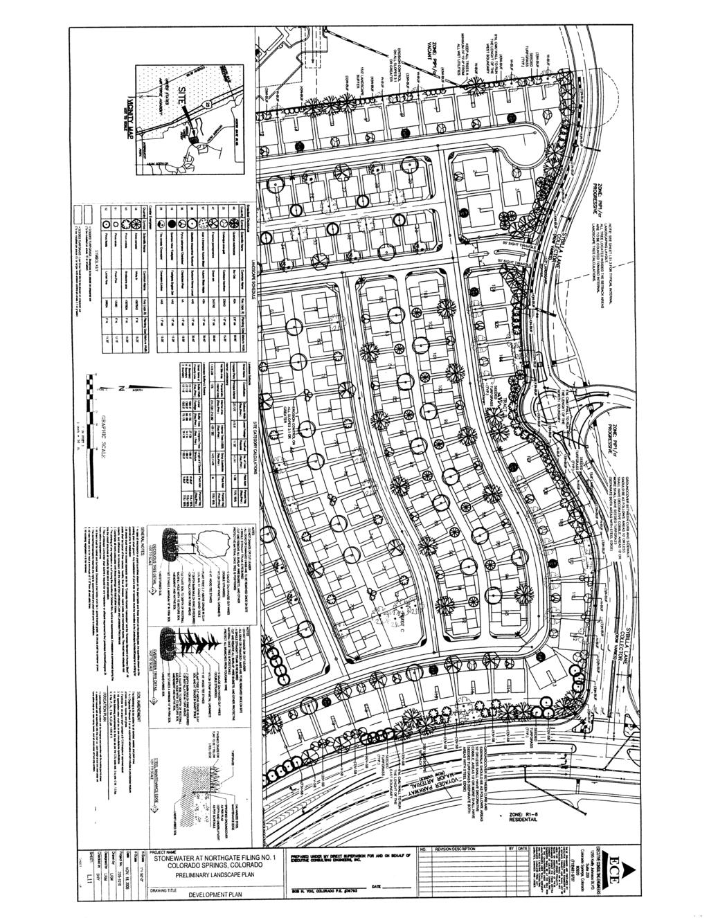
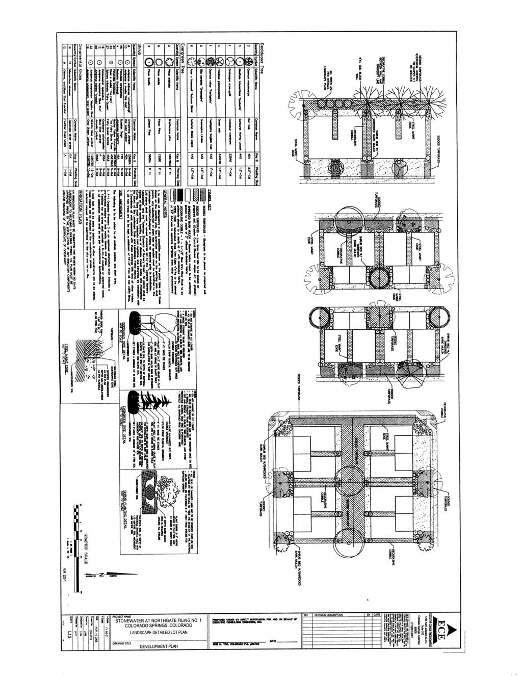
5 Page 143 Traffic Engineering: 1. The landscape plans need to include the 35 x 55 and the speed line-of-sight triangles for all intersections as identified in the Public Works Design Manual. Ensure the triangle area has no obstructions greater than 30 from the top of the roadway curb. The plans as presented do not meet the minimum standards for sight distance. 2. Call out the alleys as private. 3. Identify Middle Creek Parkway as a Minor Arterial. 4. Plans should clearly identify and call out the public sidewalk system (including width). 5. Provide a detail of the gated access entry turnaround including the keypad location. Include a autoturn diagram for the vehicle turning around to ensure the curbline is set in the correct location. Please maintain the proposed stacking behind the gates as presented on the current plans. 6. The proposed fence for the northwest corner of the site will significantly impact any future sight lines for access to the property to the west. Please show how the fence will impact the approved Concept Plan access in regards to line-of-sight. Landscape: 1. Prepare and title re-submittal as a Final Landscape Plan. 2. Soil Analysis, Preparation and Amendments reflecting Soil Analysis recommendations, is required prior to the approval of a Final Landscape Plan (Section 315.B. & C.). If deferral or waiver is requested, Alternative Compliance for this request is required. 3. Provide a Schematic Landscape Diagram for the overall site. 4. Middle Creek Parkway is classified as a minor arterial with applicable landscape setback requirements. 5. The 6 high CMU wall is to be located on the inside (property side) edge of the landscape setback or buffer. An alternative to this location may be warranted for the west boundary with a request for Alternative Compliance with appropriate justification. 6. Address the motor vehicle lot landscape requirements as they apply to the clubhouse parking area. 7. Note the installation and maintenance responsibility of landscape shown on individual lots. 8. Clearly indicate on the landscape plan the type and extent of ground plane treatments for all setbacks, buffers, and common open space areas. 9. Show the landscape intent for the parkway areas (between walk and curb) on the landscape plan. Rock areas between 4-8 in width are to be broken up with shrub plantings. Areas greater than 8 in width can be planted with turf. 10. The use of high water turf is to be limited to those areas where it will serve a functional purpose. 11. Note the seed mix of the Low Grow Seed Mix. 12. Show and note (typ) locations of site lighting. 13. Note corner visibility triangles. 14. Show /note any areas of proposed slope protection. 15. Note by type utilities and easements. Maintain a minimum 15 separation between water/wastewater and trees. 16. Correct the scale on the typical unit landscape plans. 17. Identify the typical plan type. 18. Note perimeter property line dimensions. 19. Show visibility triangles at Voyager Parkway intersections. 20. The landscape needs to be an integral part in the function of the stormwater quality pond, and conversely the engineering of the pond must provide for landscape processes in the function of stormwater quality while also considering aesthetic values. 21. Note intention for stripping and stockpiling of existing topsoil. 22. Label any grades with a slope of 4:1 or greater. 23. The Irrigation Plan is to include an irrigation schedule that notes application rates based on turf type, note rates for newly planted materials vs. established (established as a percent of initial) and general recommendations regarding seasonal adjustments (spring and fall). Ron Bevans Parks: For CPC FP , Stonewater at Northgate Filing No 1, our comments are: "Since this land is being converted from commercial to residential, it was not factored into the original parkland dedication for the master plan. Since the property is gated, no credit will be given for the internal recreation facility. Therefore parkland fees will be required in lieu of additional parkland dedication."
6 Page 144 Gas/Electric: Action Items: Approval is not recommended at this time. There may be conflicts with the proposed utility locations. The Applicant should revise sheet 4 of 17 to show each typical street and alley cross-section. Please contact Bill Davis at for more information. Water/Wastewater: Action: Update Wastewater Master Facility Report due to change in use and density. The water and wastewater main extension from Sybilla Land and Middle Creek Parkway are unacceptable. Modify the plan to show water and wastewater connections at the proposed intersections of Middle Creek Parkway and Warm Springs Drive as well as Sybilla Lane and Warm Springs Drive. The existing water and wastewater stubs will need to be removed. Extend the water main through the cul-de-sac of Rogue Loop to allow water services for lots 3-5 to connect directly to the water main. Modify the plan to show and label all existing utilities No trees will be allowed within 15 of any Public Water/Wastewater mainlines. Modify the Landscaping/Development Plan to reflect this requirement. 24 hour unrestricted access shall be provided for all public water/wastewater facilities. Show on plan how this is to be accomplished. A Wastewater Master Facility Report is required with the Development Plan submittal. Final Subdivision Plat l Action: Modify the easements paragraph to state a 7 public utility easement for the rear lot lines. Fire: Disapproved Comments: DISAPPROVED: The plans indicate that this project will be completed in 3 phases. Please show the proposed phase lines on the plans. DISAPPROVED: Rouge Loop is a looped street that extends past itself. This is not acceptable due to delays encountered during emergency response. Please adjust the design of this street or provide additional names such that this is no longer a looped street extending past itself. TURNING RADIUS: All fire apparatus access roads are to provide a minimum of 33-feet inside and 48-feet outside turning radius. (2003 IFC ) The turning radius going into the clubhouse drive from northbound Warm Spring Drive is currently inadequate. Please adjust plans to provide for adequate turning radii. GATES. Gates securing the fire apparatus access roads shall comply with all of the following criteria: 1. The minimum gate width shall be 16 feet (4877 mm) or as wide as necessary to facilitate the required minimum turning radius. 2. Gates shall be of the swinging or sliding type. 3. Construction of gates shall be of materials that allow manual operation by one person. 4. Gate components shall be maintained in an operative condition at all times and replaced or repaired when defective. 5. Electric gates shall be equipped with a Knox (TM) key system installed in an approved manner. Electronically operated gates shall have a fail safe, manually operated, Knox (TM) key override switch. 6. Manual opening gates shall not be locked with a padlock or chain and padlock unless they are capable of being opened by means of forcible entry tools. 7. Locking device specifications shall be submitted for approval by the fire code official. (2003 IFC , D103.5) Please provide a detail on your plans of the gates for the north and south exits. Ensure everything above is accounted for. Plat DISAPPROVED: Since there are outstanding issues with the development plan that could affect the final plat, the final plat will remain disapproved until such issues are resolved.
7 Page 145 Police: CPC FP was not labeled as private. This submittal is indicating the interior streets are private. If they are private the following street type designations are required: Pt(Point), Vw(View), Hts(Heights), or Gv(Grove). Rogue is duplicated as a street name. Three additional acceptable street names are required. Santiam Dr - unacceptable street name Ochoco - unacceptable street name Warm Springs - acceptable street name Rogue - may be used only once, with either a Lp or Ct street type designation. There are 4 separate accesses and each access needs an acceptable street name. Wendy Hardy, School District 20: See attached letter (FIGURE 7) in opposition. City Real Estate: 1. Plat is missing the portion of approval prepared for execution by a. City Engineer b. Manager of City Planning c. City Clerk d. El Paso County Clerk & Recorder 2. Is 6' rear easement correct or should it be 7' 3. The tracts that are "open space" look like building lots - does parks really want open space that is a building lot? 4. Tracts E & F were not included in the dedication statement. All Other Reporting Departments - Standard or no comment. PETITIONER'S JUSTIFICATION: FIGURE 1 STAKEHOLDER PROCESS: The public process involved with the review of these applications included posting of the site, and sending of letters on two separate occasions to all property owners within a 500 ft. radius of the property. ANALYSIS OF MAJOR ISSUES: MASTER PLAN REVIEW CRITERIA: In accordance with City Zoning Code Chapter 7, Article 5, Section 408, a Master Plan shall be reviewed for substantial conformance with the criteria found in said section A. Comprehensive Plan: The Comprehensive Plan and the 2020 Land Use Map are the context and the benchmark for the assessment of individual land use master plans. The proposed land use master plan or the amendment conforms to the policies and strategies of the Comprehensive Plan. The proposed land use pattern is consistent with the Citywide perspective presented by the 2020 Land Use Map. B. Land Use Relationships: 1. The master plan promotes a development pattern characterizing a mix of mutually supportive and integrated residential and nonresidential land uses with a network of interconnected streets and good pedestrian and bicycle connections. 2. Activity centers are designed so they are compatible with, accessible from and serve as a benefit to the surrounding neighborhood or business area. Activity centers also vary in size, intensity, scale and types of uses depending on their function, location and surroundings. 3. The land use pattern is compatible with existing and proposed adjacent land uses and protects residential neighborhoods from excessive noise and traffic infiltration. 4. Housing types are distributed so as to provide a choice of densities, types and affordability.
8 Page Land use types and location reflect the findings of the environmental analysis pertaining to physical characteristics which may preclude or limit development opportunities. 6. Land uses are buffered, where needed, by open space and/or transitions in land use intensity. 7. Land uses conform to the definitions contained in article 2, part 2 of this Zoning Code. C. Public Facilities: 1. The land use master plan conforms to the most recently adopted Colorado Springs parks, recreation and trails master plan. 2. Recreational and educational uses are sited and sized to conveniently service the proposed population of the master plan area and the larger community. 3. The proposed school sites meet the location, function and size needs of the school district. 4. The land use master plan conforms to the adopted plans and policies of Colorado Springs Utilities. 5. Proposed public facilities are consistent with the strategic network of long range plans. 6. The master development drainage plan conforms to the applicable drainage basin planning study and the drainage criteria manual. D. Transportation: 1. The land use master plan is consistent with the adopted intermodal transportation plan. Conformity with the intermodal transportation plan is evidence of compliance with State and local air quality implementation and maintenance plans. 2. The land use master plan has a logical hierarchy of arterial and collector streets with an emphasis on the reduction of through traffic in residential neighborhoods and improves connectivity, mobility choices and access to jobs, shopping and recreation. 3. The design of the streets and multiuse trails minimizes the number of uncontrolled or at grade trail crossings of arterials and collectors. 4. The transportation system is compatible with transit routes and allows for the extension of these routes. 5. The land use master plan provides opportunities or alternate transportation modes and cost effective provision of transit services to residents and businesses. 6. Anticipated trip generation does not exceed the capacity of existing or proposed major roads. If capacity is expected to be exceeded, necessary improvements will be identified, as will responsibility, if any, of the master plan for the construction and timing for its share of improvements. E. Environment: 1. The land use master plan preserves significant natural site features and view corridors. The Colorado Springs open space plan shall be consulted in identifying these features. 2. The land use master plan minimizes noise impacts on existing and proposed adjacent areas. 3. The land use master plan utilizes floodplains and drainageways as greenways for multiple uses including conveyance of runoff, wetlands, habitat, trails, recreational uses, utilities and access roads when feasible. 4. The land use master plan reflects the findings of a preliminary geologic hazard study and provides a range of mitigation techniques for the identified geologic, soil and other constrained natural hazard areas. F. Fiscal: 1. A fiscal impact analysis and existing infrastructure capacity and service levels are used as a basis for determining impacts attributable to the master plan. City costs related to infrastructure and service levels shall be determined for a ten (10) year time horizon for only the appropriate municipal funds. 2. The fiscal impact analysis demonstrates no adverse impact upon the general community and the phasing of the master plan is consistent with the adopted strategic network of long range plans that identify the infrastructure and service needs for public works, parks, police and fire services. 3. The cost of on site and off site master plan impacts on public facilities and services is not borne by the general community. In those situations where the master plan impacts are shown to exceed the capacity of existing public facilities and services, the applicant will demonstrate a means of increasing the capacity of the public facilities and services proportionate to the impact generated by the proposed master plan. Mitigation of on site and off site costs may include, but is not limited to, planned expansions to the facilities, amendments to the master plan, phasing
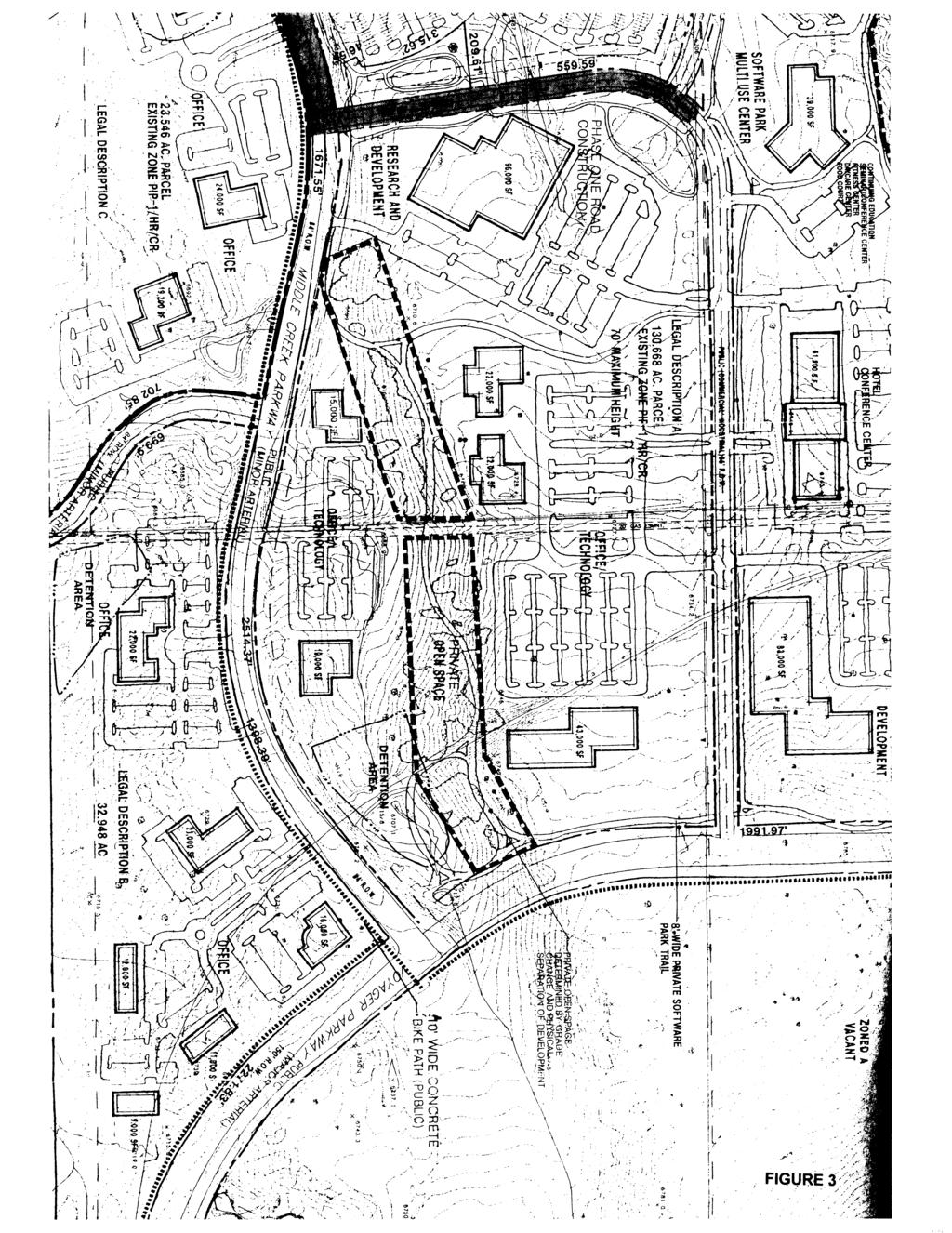
9 Page 147 of the master plan and/or special agreements related to construction and/or maintenance of infrastructure upgrades and/or service expansions. Any special agreements for mitigation of on site and off site impacts for public improvements, services and maintenance are shown to be workable and supported by financial assurances. Preexisting and/or anticipated capacity problems not attributable to the master plan shall be identified as part of the master plan review. 4. Special agreements for public improvements and maintenance are shown to be workable and are based on proportional need generated by the master plan. 5. Any proposed special districts are consistent with policies established by the City Council. (Ord ; Ord ; Ord ; Ord ; Ord ; Ord ; Ord ) This is a request for a major change of land use from Office Industrial/Research and Development with Planned Industrial Park (PIP-1) zoning to a Residential duplex use with Planned Unit Development (PUD) zoning. Staff does not support this proposed change. The applicants met with Planning staff in the pre-application process at which time staff discouraged this request. During the pre-application stage staff noted that the review criteria, compatibility with adjacent uses, preservation of scrub oak and native vegetation, appearance, setbacks, traffic and fiscal impact as issues that would need to be addressed with the application. Staff agrees with the comments of Comprehensive Planning above that the conversion of this acre property does not meet the criteria for a Land Use Map Amendment, Master Plan Amendment or residential zone change. Since the inception of the Northgate Master Plan (FIGURE 2), the area west of Voyager Parkway between North Gate Blvd. and Middle Creek Parkway has been designated for Office Industrial Park/ Research and Development land uses. Many other portions of the Northgate master plan east of Voyager have been converted from their original Office Industrial use to Residential developments. Staff has been supportive of these changes based on the use-to-use relationships with adjacent developments. In recent years, Deer Creek, Wildwood, Wildwood Ridge and Grey Hawk have all become residential. The subject property is located in the Software Park sub-area of Northgate. It was zoned into two PIP-1 High Rise districts and a concept plan (FIGURE 3) was approved in This is the last remaining vacant site in Software Park. If the area in question had been a failure in attracting Office Industrial users, the request for residential use would be understandable, but this is not the case. Several large employers have located in this industrial area. FedEx, Compassion International and Oracle have major campuses with approved plans and room for future expansions. More recently, Progressive Insurance, Nicky Cruz Foundation, and RT Logic have built employment centers with the intention of further additions. Compassion is currently constructing a major new building. The development of RT Logic Phase One, the second data center phase for Progressive and the planned third administrative office project for Progressive have further confirmed the viability of this Software Campus concept plan for Office Industrial uses. Comprehensive Plan Strategy LU 801c states that we should "Reserve designated areas for future employment centers in order to ensure the availability of sites to meet the needs of new employers, preserve a mutually supportive balance of jobs and housing within different areas of the city, and meet the projected demand for land to support new jobs." Staff believes that this property should remain in its current master plan, Land Use Map and zoning designations. These large employers are important to the economy of the City as a whole and provide jobs for residents of Northgate and adjacent master planned developments. The subject property has always been intended to be part of the Employment Center land use. Fiscal impact to the City would almost certainly be negative by replacing primary employer(s) with another residential development. (The City Budget Office does not conduct a Fiscal Impact Analysis for minor master plan amendments.) In addition to the potential loss of future primary job providers on the subject land, the insertion of a residential development into this exclusively office/industrial campus would likely have a negative impact upon the existing businesses. It would introduce the potential for conflict between residents, employers and employees. We have seen such conflict in the Northgate area before where differing uses intersect. This could lead to difficulty in retaining the employers already established in this area and might cause others to cancel their plans for expansion. Establishment of a residential zone adjacent to the existing established PIP-1 users would initiate a requirement for a 100' setback for the industrial properties. This would conflict with some plans that are already approved.
10 Page 148 Staff is supportive of mixed uses which integrate residential, office, commercial and employment centers into well designed neighborhoods. That is not what is being proposed here. This is more akin to "spot zoning" which is defined as "Rezoning of a lot or parcel of land to benefit an owner for a use incompatible with surrounding uses and not for the purpose or affect of furthering the comprehensive zoning plan." Staff understands why the property owner would like to develop and sell this property for residential use. There is little undeveloped property remaining in the Northgate master plan that is suitable or approved for residential use. The two adjacent major master plans, Allison Valley and Flying Horse Ranch, do, however, contain many vacant acres of approved residential land uses in several types and density ranges. The proposal is inconsistent with the Land Use Relationships criteria for master plan review. The duplex development would not be compatible with the adjacent land uses, nor would it protect either type of user from traffic, noise and light impacts. Some of the office developments operate on a 24 hour basis. They are currently separated from residential neighborhoods by a major arterial street, and the businesses are oriented away from the neighborhoods. Similarly, Section B.5. requires land use to reflect physical characteristics which may preclude or limit development opportunities. There is a significant ridge of mature scrub oak which is proposed to be demolished and over-lot graded. The current concept plan and zoning require this to be preserved as private open space. This is more fully discussed in the Development Plan analysis. Section B.6 requires land uses to be buffered by open space and/or transitions in land use intensity. This proposal would place homes directly adjacent to developed industrial facilities. Comprehensive Plan Policy CCA 601 requires that "New developments will be compatible with the surrounding land uses and will complement the character and appearance of adjacent land uses." Staff finds that the criteria are not met to approve this master plan amendment. The negative long term impacts to the City would outweigh the short term benefits to the applicant. Staff recommends denial. CONFORMANCE WITH COMPREHENSIVE PLAN 2020 LAND USE MAP, STRATEGIES AND OBJECTIVES: The objective of the 2020 Land Use Map (FIGURE 4) is to provide a Citywide context for development decisions. Strategy LUM 101B states that master plans should be used to make more detailed land use decisions because they take additional information such as topography, site constraints, road alignments and use-to-use relationships into account. The subject property is designated as an Employment Center and the property clearly meets the definition and characteristics of an employment center. The applicant is requesting a change to the Low Residential category. The master plan analysis above argues against revising the Land Use Map. Staff, therefore, recommends denial. ZONE CHANGE REVIEW CRITERIA: In accordance with City Zoning Code Chapter 7, Article 5, Section 603.B, a proposal for a change of zone classification may be approved by the City only if the following findings are made: 1. The action will not be detrimental to the public interest, health, safety, convenience or general welfare. 2. The proposal is consistent with the goals and policies of the City Comprehensive Plan. 3. The proposal is consistent with the master plan for the area, in which the parcel is located, unless the master plan is deemed implemented. PUD ZONE DISTRICT ESTABLISHMENT CRITERIA: In accordance with City Zoning Code Chapter 7, Article 3, Part 6, the purpose of a PUD district is as follows: A. To implement the Comprehensive Plan of the City of Colorado Springs by promoting development that is characterized by a variety of mutually supportive and integrated residential and nonresidential land uses. B. To allow for a variety of residential, commercial, office and industrial land use types and encourage appropriate mixed use developments. This zone district is intended to provide the means through which land may be developed with an overall unified approach. The district encourages flexibility in design to
11 Page 149 create a better living environment, to preserve the unique features of the site and to provide public services in a more economic manner. C. To encourage flexibility, innovation of design and a variety of development types that will improve the quality of physical development over that normally achieved through the application of the City's standard single use zones. D. To provide a clear and reasonable plan for the phased development and completion of proposed development, consistent with the Comprehensive Plan for the City of Colorado Springs. (Ord ; Ord ) Staff recommends denial of the zone change to PUD for similar reasons described in the Master Plan section. None of the three general zone change criteria are met. Establishment of a PUD zone would be detrimental to the public interest, safety and general welfare, and would be inconsistent with the Comprehensive Plan as noted above. The proposal is not consistent with the approved Northgate master plan, and staff has recommended against changing the master plan to accommodate this new zone. Criteria A and B of the PUD-specific zone change criteria encourage integrated and unified mixed developments. This proposal would create an isolated residential development that would detract from instead of complement the surrounding office campus uses. As mentioned elsewhere, the land use type and proposed density of the zone would lead to demolition of the unique features of the site. Criterion C is not met either. There is little flexibility, innovation of design or variety of development types inherent in the plan. All are duplexes lined up in parallel rows to maximize the number of units that can fit on the property. Staff finds that the criteria are not met to approve a PUD zone : REVIEW CRITERIA FOR DEVELOPMENT PLAN: A development plan for land within a PUD zone shall be approved if it substantially conforms to the approved PUD plan and the development plan review criteria listed below. The standards and other requirements set forth in a development agreement may be used to demonstrate compliance with development plan review criteria. An application for a development plan shall be submitted in accord with requirements outlined in article 5, parts 2 and 5 of this chapter. Unless otherwise specified by a development agreement, the project shall be vested by the development plan in accord with section and subsection C2 of this chapter. A. Consistency With City Plans: Is the proposed development consistent with the Comprehensive Plan or any City approved master plan that applies to the site? B. Consistency With Zoning Code: Is the proposed development consistent with the intent and purposes of this Zoning Code? C. Compatibility Of The Site Design With The Surrounding Area: 1. Does the circulation plan minimize traffic impact on the adjacent neighborhood? 2. Do the design elements reduce the impact of the project's density/intensity? 3. Is placement of buildings compatible with the surrounding area? 4. Are landscaping and fences/walls provided to buffer adjoining properties from undesirable negative influences that may be created by the proposed development? 5. Are residential units buffered from arterial traffic by the provision of adequate setbacks, grade separation, walls, landscaping and building orientation? D. Traffic Circulation: 1. Is the circulation system designed to be safe and functional and encourage both on and off site connectivity? 2. Will the streets and drives provide logical, safe and convenient vehicular access to the facilities within the project? 3. Will adequately sized parking areas be located to provide safe and convenient access, avoid excessive parking ratios and avoid expanses of pavement? 4. Are access and movement of handicapped persons and parking of vehicles for the handicapped appropriately accommodated in the project design? 5. As appropriate are provisions for transit incorporated?
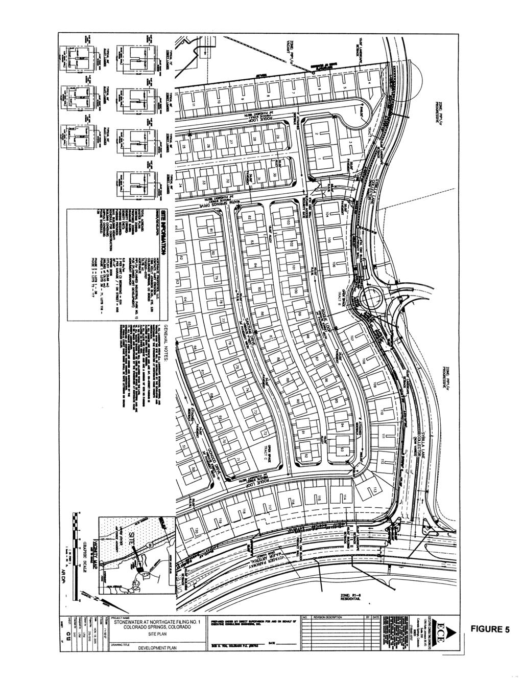
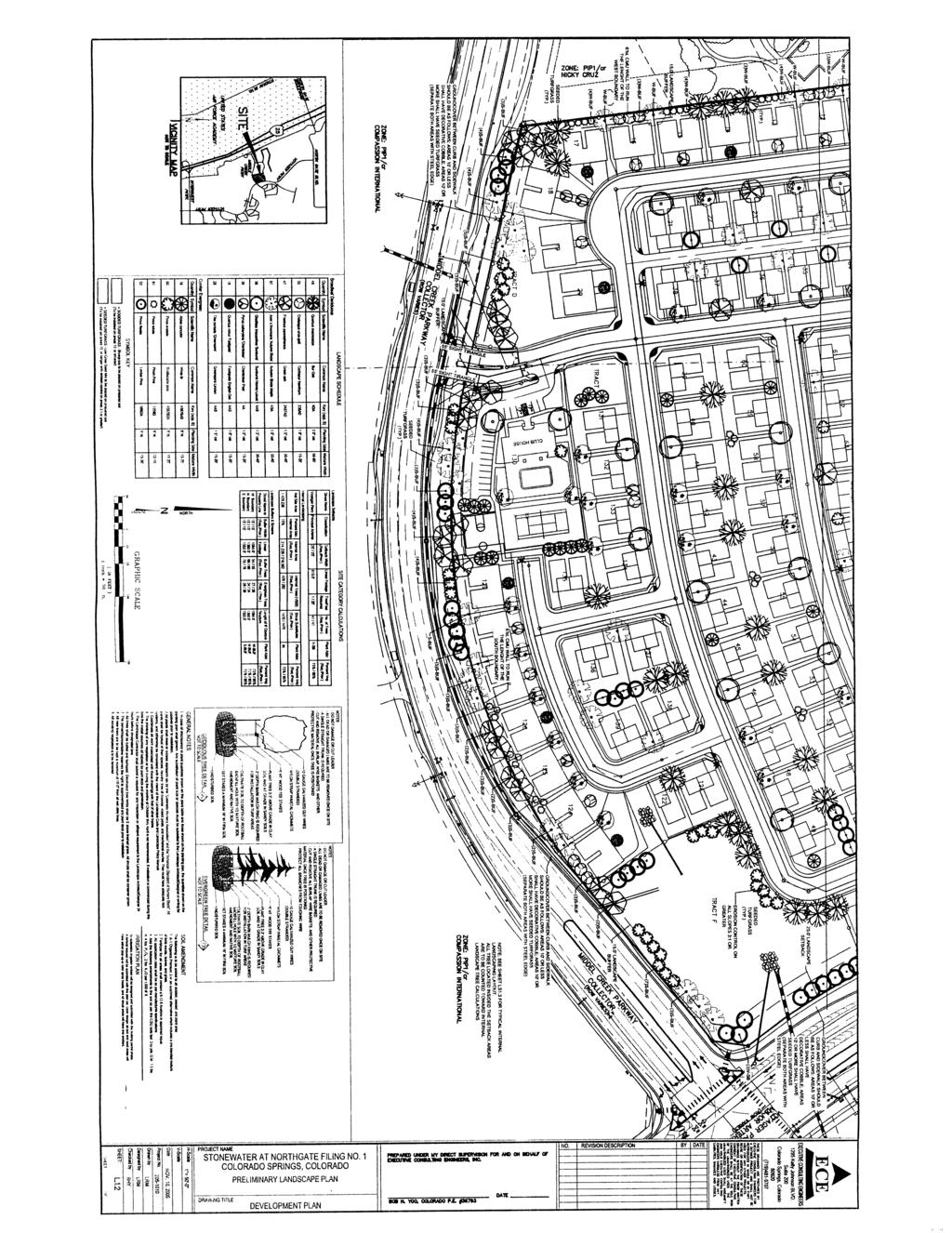
12 Page 150 E. Overburdening Of Public Facilities: Will the proposed development overburden the capacities of existing and planned streets, utilities, parks, and other public facilities? F. Privacy: Is privacy provided, where appropriate, for residential units by means of staggered setbacks, courtyards, private patios, grade separation, landscaping, building orientation or other means? G. Pedestrian Circulation: 1. Are pedestrian facilities provided, particularly those giving access to open space and recreation facilities? 2. Will pedestrian walkways be functionally separated from vehicular ways and located in areas that are not used by motor vehicles? H. Landscaping: 1. Does the landscape design comply with the City's landscape code and the City's landscape policy manual? 2. The use of native vegetation or drought resistant species including grasses is encouraged. The City's landscape policy manual or City Planning's landscape architect can be consulted for assistance. I. Open Space: 1. Residential Area: a. Open Space: The provision of adequate open space shall be required to provide light, air and privacy; to buffer adjacent properties; and to provide active and passive recreation opportunities. All residential units shall include well designed private outdoor living space featuring adequate light, air and privacy where appropriate. Common open space may be used to reduce the park dedication requirements if the open space provides enough area and recreational facilities to reduce the residents' need for neighborhood parks. Recreational facilities shall reflect the needs of the type of residents and proximity to public facilities. b. Natural Features: Significant and unique natural features, such as trees, drainage channels, slopes, and rock outcroppings, should be preserved and incorporated into the design of the open space. The Parks and Recreation Advisory Board shall have the discretion to grant park land credit for open space within a PUD development that preserves significant natural features and meets all other criteria for granting park land credit. 2. Nonresidential And Mixed Use; Natural Features: The significant natural features of the site, such as trees, drainage channels, slopes, rock outcroppings, etc., should be preserved and are to be incorporated into the design of the open space. The development plan for Stonewater at Northgate Fil. No. 1 (FIGURE 5) shows 139 duplexes (278 dwelling units) on acres located west of Voyager Pkwy., north of Middle Creek Pkwy. and south of Sybilla Lane. It shows one gated entrance on Sybilla and a second gated entrance on Middle Creek. All internal streets are private. A small clubhouse building with a swimming pool, tennis court and basketball court is located adjacent to the Middle Creek entrance. A detention pond occupies the southeast corner of the site. The duplex units are shown on the plan with no variation in setbacks. The appearance from the streets would be straight linear rows of garage doors for the street-loaded units. The alley-loaded buildings don't show variation in setbacks either. This conflicts with Section C.2 which advocated design elements that reduce the impact of the project's density/intensity. There is a significant stand of mature scrub oak and native vegetation present, running along a ridge from east to west in the center of the site. The approved zoning and Software Park concept plan requires this area to be preserved as a large private open space tract. It shows a 43,000 sq. ft. office building in the north, and an entirely separate 19,000 sq. ft. building in the south. The concept plan note specifies physical separation of the two developments. In our pre-application meeting with the applicant, staff noted that preservation of views, scrub oak and native vegetation were important issues to be addressed in the review of this project. The development plan proposes to overlot grade the entire site and destroy all the existing vegetation. It violates several development plan review criteria by failing to preserve significant views, native vegetation and natural features. The adjacent property to the west complied with this same condition and preserved even more area than was required by the concept plan. If this residential land use is approved, the site should be redesigned as two separate residential projects north and south of the open space.
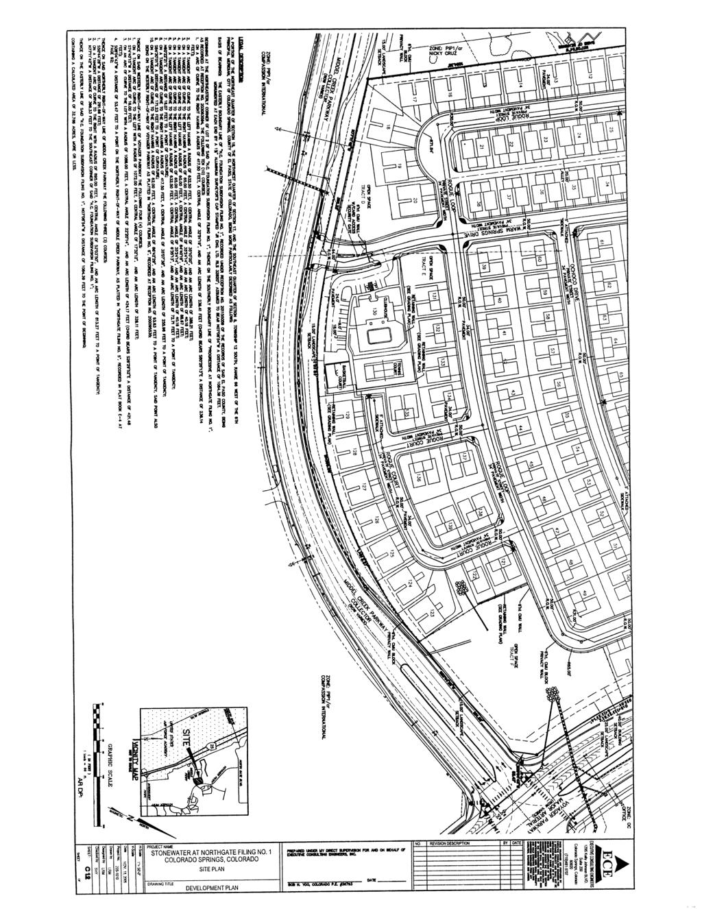
13 Page 151 The surrounding properties on the north, south and west are zoned PIP-1. The PIP-1 zone requires a minimum 100' setback for all structures from a residential zone. Normally, this restriction is placed on the PIP-1 property with the assumption that the residential zone is in place before the PIP-1 property develops. In this case, the PIP-1 zone is in place and the surrounding properties already have development plans approved with some setbacks less than 100'. Therefore, the residential property would need to provide the required buffer. The development plan shows duplexes 20' from the west property line. Staff would consider variances for reduced setback dimensions depending on topography, vertical barriers and the depth and quality of landscape materials. The approval of the surrounding office industrial property owners would be an important consideration. This property is adjacent to Voyager Pkwy., a major arterial road. A sound wall or similar barrier or increased setback would be required to protect residents from noise impacts associated with this road. Alternatively, a professional noise study could be commissioned to propose another method to comply with City policy. Staff recommends denial of the development plan. If Planning Commission decides that residential land use is appropriate for this site, the plans should be revised to comply with the comments above and those listed below. Since it will entail a major redesign, the new plans would need to be resubmitted to all agencies for a complete re-review and should also be returned to Planning Commission for consideration when revised plans are complete. Just to be clear, staff does not support a residential use in this location. The comments listed here are to be used as guidance for a redesigned development plan if the Planning Commission and/or City Council approve the land use change: 1. Provide a Private Open Space as shown on the Software Park concept plan. No vegetation removal or grading is to occur in this area. The result will be two separate residential developments. Revise the plans to be consistent with this major change. 2. Revise the plan to comply with the City's noise policy for residential developments adjacent to major roads. 3. Provide required buffers and setbacks from the adjacent PIP-1 properties. 4. Show the correct gross and net densities in the Site Information table. 5. Provide a phasing drawing showing which improvements are to be completed with each phase. 6. For street-loaded garages, provide minimum 20' front setbacks from the back of sidewalks to permit parking in driveways without blocking pedestrians. 7. For all lots, provide increased lot depths to permit staggered setbacks that would relieve the monotonous linear placement of buildings along the streets. 8. Revise the Parking Provided information in the Site Data table. On street parking cannot be counted to meet parking requirements. 9. Tract F is a detention pond. Label it as a detention pond, not open space. 10. City policy is to provide a minimum of 200 sq. ft. of usable open space per bedroom for multi family developments. Show how this is to be accomplished. Some credit will be given for the clubhouse, pool and two courts. 11. Redesign the site as necessary to address City Engineering issues. 12. Provide the required details to address Traffic Engineering issues. 13. Address Landscape issues. 14. Address Gas/Electric action issues. 15. Address Water/ Wastewater action issues. 16. Address all Fire disapproval issues. 17. Provide acceptable private street names and address Police street naming issues. 18. Address issues raised by the City s Real Estate Services Office. SUBDIVISION PLAT REVIEW CRITERIA AND : In accordance with City Subdivision Code Chapter 7, Article 7, Section 102 of the City Subdivision Code Chapter 7, a subdivision plat shall be reviewed using the standards found in said section. Specifically, to promote the health, safety, convenience, and general welfare of the citizens of the City; to set forth appropriate standards for subdivision design; to set forth appropriate standards for utilities and services; to assure the
14 Page 152 provision of adequate and safe circulation; to assure adequate public facilities can be provided; and that the development conforms to the goals and policies of City Comprehensive Plan. The subdivision plat for Stonewater at Northgate Fil. No. 1 (FIGURE 6) follows the development plan that was submitted and shows the entire proposed site. Staff is recommending denial of the other applications and must, therefore, recommend denial of the plat. If the land use and other requests are approved, the plat should be revised to comply with them. For some reason, the plat states that the internal and perimeter landscape tracts are to be owned and maintained by the City. This must be changed. It is the finding of the Planning Staff that the Stonewater at Northgate Fil. No. 1 Subdivision Plat is not in compliance with the standards found in City Subdivision Code Chapter 7, Article 7. If, however, all the other accompanying requests are approved, the subdivision plat needs to conform to the development plan and the plat-specific comments from the agencies listed above.
15 Page 153
16 Page 154
17 Page 155
18 Page 156
19 Page 157
20 Page 158
21 Page 159
22 Page 160
23 Page 161
CITY PLANNING COMMISSION AGENDA ITEM: C STAFF: ROBERT TEGLER FILE NO: CPC PUD QUASI-JUDICIAL
 CPC AGENDA June 8, 2006 Page 37 CITY PLANNING COMMISSION AGENDA ITEM: C STAFF: ROBERT TEGLER FILE NO: CPC PUD 05-294 - QUASI-JUDICIAL PROJECT: APPLICANT: OWNER: PARKWOOD AT WOLF RANCH NASS DESIGN ASSOCIATES
CITY PLANNING COMMISSION AGENDA ITEMS: 11, 12, 13 STAFF: RYAN TEFERTILLER
 Page 139 CITY PLANNING COMMISSION AGENDA ITEMS: 11, 12, 13 STAFF: RYAN TEFERTILLER FILE NO(s): CPC PUZ 05-00047 QUASI-JUDICIAL CPC PUD 05-00048 QUASI-JUDICIAL CPC FP 05-00049 QUASI-JUDICIAL PROJECT: RIDGEVIEW
CITY PLANNING COMMISSION AGENDA. ITEM NO(s): C.1 C.3 STAFF: STEVE TUCK
: C.1 C.3 STAFF: STEVE TUCK") Page 34 CITY PLANNING COMMISSION AGENDA ITEM NO(s): C.1 C.3 STAFF: STEVE TUCK FILE NOS: CPC ZC 12-00035 QUASI-JUDICIAL CPC NV 12-00036 QUASI-JUDICIAL AR DP 12-00039 QUASI-JUDICIAL PROJECT: APPLICANT: OWNER:
Page 34 CITY PLANNING COMMISSION AGENDA ITEM NO(s): C.1 C.3 STAFF: STEVE TUCK FILE NOS: CPC ZC 12-00035 QUASI-JUDICIAL CPC NV 12-00036 QUASI-JUDICIAL AR DP 12-00039 QUASI-JUDICIAL PROJECT: APPLICANT: OWNER:
CITY PLANNING COMMISSION AGENDA ITEM NO: 8 STAFF: ANDREW FIRESTINE FILE NO: CPC PUD QUASI-JUDICIAL
 Page 97 CITY PLANNING COMMISSION AGENDA ITEM NO: 8 STAFF: ANDREW FIRESTINE FILE NO: CPC PUD 05-00232 QUASI-JUDICIAL PROJECT: APPLICANT: OWNER: CORNERSTONE BAPTIST CHURCH BILL BROWN AIA P.C. CORNERSTONE
CITY PLANNING COMMISSION AGENDA ITEMS: C.1, C.2 STAFF: MEGGAN HERINGTON FILE NO(S): CPC PUZ QUASI-JUDICIAL CPC PUD QUASI-JUDICIAL
: CPC PUZ QUASI-JUDICIAL CPC PUD QUASI-JUDICIAL") Page 32 CITY PLANNING COMMISSION AGENDA ITEMS: C.1, C.2 STAFF: MEGGAN HERINGTON FILE NO(S): CPC PUZ 13-00036 QUASI-JUDICIAL CPC PUD 13-00037 QUASI-JUDICIAL PROJECT: APPLICANT: OWNER: ESTANCIA AT CORDERA
Page 32 CITY PLANNING COMMISSION AGENDA ITEMS: C.1, C.2 STAFF: MEGGAN HERINGTON FILE NO(S): CPC PUZ 13-00036 QUASI-JUDICIAL CPC PUD 13-00037 QUASI-JUDICIAL PROJECT: APPLICANT: OWNER: ESTANCIA AT CORDERA
CONSENT CALENDAR CITY PLANNING COMMISSION AGENDA ITEM NO: A.1, A.2 STAFF: LARRY LARSEN
 Page 8 CONSENT CALENDAR CITY PLANNING COMMISSION AGENDA ITEM NO: A.1, A.2 STAFF: LARRY LARSEN FILE NO: CPC PUZ 14-00013 - QUASI-JUDICIAL FILE NO: CPC PUD 14-00014 QUASI-JUDICIAL PROJECT: APPLICANT: OWNER:
CITY PLANNING COMMISSION AGENDA. ITEM NO: 6.a 6.b STAFF: LONNA THELEN
 Page 156 CITY PLANNING COMMISSION AGENDA ITEM NO: 6.a 6.b STAFF: LONNA THELEN FILE NO(S): A. - CPC ZC 08-00069 QUASI-JUDICIAL B. - CPC CU 08-00070 QUASI-JUDICIAL PROJECT: APPLICANT: OWNER: PHIL LONG VALUCAR
Asbury Chapel Subdivision Sketch Plan
 Asbury Chapel Subdivision Sketch Plan PART 1: PROJECT SUMMARY Applicant: NVR Inc. Project Size: +/- 76.13 acres Parcel Numbers: 02101112,02116101,02116112, 02116113 Current Zoning: Transitional Residential
PLANNED UNIT DEVELOPMENT & SUBDIVISION STAFF REPORT Date: May 18, 2017
 & PUD-0000102-2017 PLANNED UNIT DEVELOPMENT & SUBDIVISION STAFF REPORT Date: May 18, 2017 NAME SUBDIVISION NAME Dauphin Creek Estates Subdivision Dauphin Creek Estates Subdivision LOCATION CITY COUNCIL
CONSENT CALENDAR CITY PLANNING COMMISSION AGENDA ITEM: A.1-A.3 STAFF: STEVE TUCK
 Page 8 CONSENT CALENDAR CITY PLANNING COMMISSION AGENDA ITEM: A.1-A.3 STAFF: STEVE TUCK FILE NOS: 1. - CPC MPA 07-00308-A4MJ09 LEGISLATIVE 2. - CPC PUZ 09-00057 QUASI-JUDICIAL 3. - CPC PUD 09-00058 QUASI-JUDICIAL
PART 1: PROJECT SUMMARY. Proposed Land Use: 120 single-family lots. The application is Attachment A. The site plan is Attachment B.
 PART 1: PROJECT SUMMARY Applicant: JBH Development, LLC and Hopper Communities, INC Project Size: +/- 80.48 acres Parcel Number: 01513107, 01513108, 01513109, 01513113, 01513120, 01513121, 01513122, 01513124,
ARTICLE 13 STREETS General
 ARTICLE 13 STREETS 13.1 General Streets shall be designed to suit their functions. Many streets have purposes other than vehicular traffic. As an alternative to current N.C. Department of Transportation
A BILL FOR AN ORDINANCE TO AMEND CHAPTER 9, KAUAI COUNTY CODE 1987, RELATING TO STREET REQUIRE:MENTS FOR SUBDIVISIONS
 ORDINANCE NO. BILL NO. { vy"yj1j A BILL FOR AN ORDINANCE TO AMEND CHAPTER 9, KAUAI COUNTY CODE 1987, RELATING TO STREET REQUIRE:MENTS FOR SUBDIVISIONS BE IT ORDAINED BY THE COUNCIL OF THE COUNTY OF KAUA'I,
CITY PLANNING COMMISSION AGENDA ITEM NO: 11 STAFF: JIM GAGLIARDI FILE NO: CPC CU QUASI-JUDICIAL
 Page 203 CITY PLANNING COMMISSION AGENDA ITEM NO: 11 STAFF: JIM GAGLIARDI FILE NO: CPC CU 08-00095 QUASI-JUDICIAL PROJECT: APPLICANT: OWNER: CHARTER SCHOOL CONDITIONAL USE PERMIT LAND DEVELOPMENT CONSULTANTS,
AWH REPORT OF THE PLANNING AND DEVELOPMENT DEPARTMENT FOR APPLICATION FOR REZONING ORDINANCE TO PLANNED UNIT DEVELOPMENT
 AWH REPORT OF THE PLANNING AND DEVELOPMENT DEPARTMENT FOR APPLICATION FOR REZONING ORDINANCE TO PLANNED UNIT DEVELOPMENT MAY 8, 2014 The Planning and Development Department hereby forwards to the Planning
COMMUNITY DESIGN. GOAL: Create livable and attractive communities. Intent
 COMMUNITY DESIGN Intent An attractive, well-designed County will attract quality development, instill civic pride, improve the visual character of the community, and create a strong, positive image for
ARTICLE IV: DEVELOPMENT STANDARDS 404 MASTER PLANNING
 IV 13 404 MASTER PLANNING Master Planning through the Site Analysis (Master Planning Site Analysis) or Planned Development (Master Planning Planned Development) is provided to encourage development which
EXHIBIT B PROJECT NARRATIVE POULSBO MEADOWS
 EXHIBIT B PROJECT NARRATIVE POULSBO MEADOWS Name of Project: Poulsbo Meadows; A Planned Residential Development (PRD)/Plat Applicants Name: PBH Group LLC/Byron Harris PO Box 1010 Silverdale, WA 98038 Description
City of Lafayette Study Session Staff Report Design Review Commission
 City of Lafayette Study Session Staff Report Design Review Commission Meeting Date: April 24, 2017 Staff: Payal Bhagat, Senior Planner Subject: HDP18-15 & HDP31-15 Ramesh Patel & Melcor Development (Owners),
ARTICLE 6: Special and Planned Development Districts
 ARTICLE 6: Special and Planned Development Districts 6-10 Traditional Neighborhood Development (TND) District 6-10.10 Purpose and Intent The Traditional Neighborhood Development (TND) District provides
Gold Line Bus Rapid Transit Transit Oriented Development (BRTOD) Helmo Station Area Plan
 Helmo Station Area Plan") Appendix F Gold Line Bus Rapid Transit Transit Oriented Development (BRTOD) Helmo Station Area Plan Introduction and Purpose of the Plan The Gold Line Bus Rapid Transit facility is an eleven-mile dedicated
Appendix F Gold Line Bus Rapid Transit Transit Oriented Development (BRTOD) Helmo Station Area Plan Introduction and Purpose of the Plan The Gold Line Bus Rapid Transit facility is an eleven-mile dedicated
Major Subdivision Sketch Plan Checklist
 This checklist provides specific requirements that are apart of the Sketch process. The entire process is described by the Huntersville Subdivision Review Process which details all the submittal and resubmittal
CHAPTER 22 Rural Open Space Community Developments
 CHAPTER 22 Rural Open Space Community Developments Section 22.1 Description and Purpose The intent of this Chapter is to offer property owners an alternative to traditional zoning requirements for rural
4.1.3 LAND USE CATEGORIES
 4.1.3 LAND USE CATEGORIES a. City Center District The City Center District incorporates the existing character and mix of uses in downtown Belmont to encourage redevelopment and new development in keeping
ARTICLE 13 STREETS General
 ARTICLE 13 STREETS 13.1 General Streets shall be designed to suit their functions. Many streets have purposes other than vehicular traffic. As an alternative to current N.C. Department of Transportation
Town of Portola Valley General Plan. Nathhorst Triangle Area Plan
 Town of Portola Valley General Plan Amended December 10, 1997 Table of Contents Introduction... 1 Planning Area... 1 Objectives... 2 Principles... 2 Standards... 4 Description... 4 Community Commercial...
Harmony Technology Park Third Filing, Second Replat Custom Blending, Project Development Plan/Final Development Plan - FDP #130021
 ITEM NO FDP #130021 MEETING DATE July 23, 2013 STAFF Pete Wray ADMINISTRATIVE TYPE I HEARING STAFF REPORT PROJECT: APPLICANT: OWNER: Harmony Technology Park Third Filing, Second Replat Custom Blending,
North Oakville East Parks Facilities Distribution Plan. November, 2009
 North Oakville East November, 2009 POLICY CONTEXT 1) Purpose a) The purpose of this document is to be a guide for the location, configuration, design and development of the parks system for the North Oakville
F. Driveways. Driveways which provide access to off-street parking or loading from public streets shall comply with the following:
 Section 20.945.040 General Design Standards for Surface Parking Areas. A. Review Authority. Parking lot design and drainage shall be subject to review and approval of the City Transportation Manager. B.
TOP TEN LIST OF COMMUNITY CONCERNS REGARDING PROPOSED AMENDMENTS TO CHAPTER 42
 TOP TEN LIST OF COMMUNITY CONCERNS REGARDING PROPOSED AMENDMENTS TO CHAPTER 42 1. Extend the urban area to Beltway 8 in stages, over say a three-year period, prioritizing development in transit and declining
CITY OF ZEELAND PLANNING COMMISSION
 APPLICATION FOR SITE PLAN REVIEW AND SPECIAL LAND USE Date City Official App. Filing Fee Rec'd ($350) NOTE TO APPLICANT: Please submit this application for Site Plan Review along with twenty (20) copies
VILLAGE OF CLEMMONS PLANNING BOARD DRAFT STAFF REPORT
 VILLAGE OF CLEMMONS PLANNING BOARD DRAFT STAFF REPORT PETITION INFORMATION Docket # C-226 Staff Megan Ledbetter Petitioner(s) JBJH Properties, LLC Owner(s) JBJH Properties, LLC Subject Property 5892-49-1766
CITY PLANNING COMMISSION AGENDA ITEM: K STAFF: STEVE TUCK FILE NO.: CPC CU QUASI-JUDICIAL
 Page 92 CITY PLANNING COMMISSION AGENDA ITEM: K STAFF: STEVE TUCK FILE NO.: CPC CU 08-00043 QUASI-JUDICIAL PROJECT: APPLICANT: OWNER: COTTONWOOD ARTISTS SCHOOL & ART GALLERY COTTONWOOD ARTISTS SCHOOL ELMER
3.10 LAND USE SETTING PROJECT SITE EXISTING LAND USE DESIGNATIONS AND ZONING. General Plan Land Use Designations.
 This section of the Draft EIR addresses the existing land uses on and adjacent to the project site and discusses the potential impacts of the proposed project on existing land uses. Key issues addressed
SITE CITY PLANNING COMMISSION AGENDA ITEM NO: 5 STAFF: LONNA THELEN FILE NO: CPC CU QUASI-JUDICIAL ART C. KLEIN CONSTRUCTION
 Page 58 CITY PLANNING COMMISSION AGENDA ITEM NO: 5 STAFF: LONNA THELEN FILE NO: CPC CU 10-00022 QUASI-JUDICIAL PROJECT: APPLICANT: OWNER: COLORADO SPRINGS CHARTER ACADEMY ART C. KLEIN CONSTRUCTION COLORADO
Baumgarten MPUD. Exhibit 3 Evaluation Criteria
 Pursuant to LDC subsections 10.02.13 B, 10.02.08 F and Chapter 3 G. of the Administrative Code, staff s analysis and recommendation to the Planning Commission, and the Planning Commission s recommendation
Planned Development Review Revisions (Project No. PLNPCM )
") Planned Development Review Revisions (Project No. PLNPCM2014-00139) Standard residential development Planned Development Example: Smaller lot sizes than what is allowed to create open space amenity. What
Planned Development Review Revisions (Project No. PLNPCM2014-00139) Standard residential development Planned Development Example: Smaller lot sizes than what is allowed to create open space amenity. What
Planning Commission Staff Report June 5, 2008
 Owner/Applicant Taylor Village Sacramento Investments Partners, LP c/o Kim Whitney 1792 Tribute Road #270 Sacramento, CA 95815 Staff Recommendation Planning Commission Staff Report Project: File: Request:
5.1.1 The streetscape along US Highway 64 (Brevard Road); and, The built environment within new residential developments; and,
; and, The built environment within new residential developments; and,") Article 5. Landscaping 5.1 Purpose The Town of Laurel Park s landscape standards are designed to create a beautiful, aesthetically pleasing built environment that will complement and enhance community
Article 5. Landscaping 5.1 Purpose The Town of Laurel Park s landscape standards are designed to create a beautiful, aesthetically pleasing built environment that will complement and enhance community
PROPOSED BLOCK LENGTH CODE AMENDMENT
 10.426 Street Circulation Design and Connectivity. These standards are intended to assure that development will ultimately result in complete blocks bound by a network of public streets, and/or private
City of Lafayette Study Session Staff Report Design Review Commission
 ++ City of Lafayette Study Session Staff Report Design Review Commission Meeting Date: January 08, 2018 Staff: Subject: Chris Juram, Planning Technician SS12-17 Miramar Homebuilders, R-20 Zoning: Request
PRELIMINARY PLAT DESIGN REQUIREMENTS Updated 4/8/2016
 PRELIMINARY PLAT DESIGN REQUIREMENTS Updated 4/8/2016 The following items are required for the preliminary plat. Numbers correspond with those on the example preliminary plat. RENO COUNTY SUBDIVISION REQUIREMENTS
ARTICLE 17 SITE PLAN REVIEW
 ARTICLE 17 SITE PLAN REVIEW 17.01 INTENT AND PURPOSE The intent of this section is to provide for consultation and cooperation between the applicant and the township planning commission so that the applicant
Exhibit A. 8:9 Scuffletown Rural Conservation District
 Exhibit A 8:9 Scuffletown Rural Conservation District 8:9.1 Intent and Purpose The Scuffletown Rural Conservation (SRC) District is intended to provide for residential development that supports the development
VILLAGE OF CLEMMONS PLANNING BOARD DRAFT STAFF REPORT. Single Family Residential, Townhomes
 VILLAGE OF CLEMMONS PLANNING BOARD DRAFT STAFF REPORT PETITION INFORMATION Docket # C-212 Staff Megan Ledbetter Petitioner(s) Peacehaven Development LLC Owner(s) Larry Jarvis, William Alexander and Peacehaven
SECTION E. Realizing the Plan
 SECTION E Realizing the Plan 60 DESIGN REGINA - OFFICIAL COMMUNITY PLAN SECTION E Realizing the Plan Design Regina has been an ambitious plan-making exercise, with a high level of community, stakeholder,
Landscape and fencing requirements of this Chapter shall apply to all new landscaped areas.
 Chapter 19.06. Landscaping and Fencing. Sections: 19.06.01. Purpose. 19.06.02. Required Landscaping Improvements. 19.06.03. General Provisions. 19.06.04. Landscaping Plan. 19.06.05. Completion of Landscape
Access Management: An Overview
 Figures 1-5 Below Evolution of development along a highway. In the early stages, land along the road is used for farming with little traffic generated. As time passes, the highway corridor becomes a de
Glenborough at Easton Land Use Master Plan
 Implementation 114 9.0 IMPLEMENTATION 9.1 OVERVIEW This chapter summarizes the administrative procedures necessary to implement the proposed land use plan, infrastructure improvements, development standards,
CITY PLANNING COMMISSION AGENDA
 Page 22 CITY PLANNING COMMISSION AGENDA ITEM: C STAFF: STEVE TUCK FILE NO: CPC CU 11-00080 QUASI-JUDICIAL PROJECT: FIRST & MAIN APARTMENTS PHASE 1 APPLICANT: OWNER: NASS DESIGN ASSOCIATES FIRST & MAIN
City of Lafayette Staff Report
 City of Lafayette Staff Report For: By: Design Review Commission Greg Wolff, Senior Planner Meeting Date: April 27, 2015 Subject: SS03-15 Gundi & Peter Younger (Owners), R-40 Zoning: Request for a Study
Chapter 3 Site Planning and Low Impact Development
 CHAPTER 3 Site Planning and Low Impact Development Chapter 3 Site Planning and Low Impact Development 3.0 Introduction The City of Charleston requires that major residential, large commercial (>1 acre),
Dwelling Units Max 12 dwelling units per acre/min 8 dwelling units per acre. Development Mix 80% non residential/20% residential
 13. OSTEEN LOCAL PLAN Background: The Osteen Local Plan area is located in southwest Volusia County along the SR 415 corridor between Lemon Bluff Road and Acorn Lake Road and includes 3,990 acres. The
Planned Residential Neighborhoods Land Use Goals
 Planned Residential Neighborhoods Land Use Goals Issue: Guidelines that provide for diverse high quality residential areas that include a variety of housing styles and layouts are needed. Goal 1: Create
FORMER CANADIAN FORCES BASE (CFB) ROCKCLIFFE SECONDARY PLAN. Official Plan Amendment XX to the Official Plan for the City of Ottawa
 ROCKCLIFFE SECONDARY PLAN. Official Plan Amendment XX to the Official Plan for the City of Ottawa") FORMER CANADIAN FORCES BASE (CFB) ROCKCLIFFE SECONDARY PLAN Official Plan Amendment XX to the Official Plan for the City of Ottawa 1 INDEX THE STATEMENT OF COMPONENTS PART A THE PREAMBLE PAGE Purpose...
FORMER CANADIAN FORCES BASE (CFB) ROCKCLIFFE SECONDARY PLAN Official Plan Amendment XX to the Official Plan for the City of Ottawa 1 INDEX THE STATEMENT OF COMPONENTS PART A THE PREAMBLE PAGE Purpose...
II. SINGLE FAMILY RESIDENTIAL
 II. SINGLE FAMILY RESIDENTIAL Castle Rock is made up of numerous individually built houses and subdivision tracts that have been developed during the past century. Some of the tracts are diverse in architectural
BYLAW C A Bylaw of Rocky View County to amend Land Use Bylaw C
 BYLAW C-7720-2017 A Bylaw of Rocky View County to amend Land Use Bylaw C-4841-97. The Council of Rocky View County enacts as follows: PART 1 TITLE This Bylaw shall be known as Bylaw C-7720-2017. PART 2
At Your Disposal CUP Amendment, Lot 20, Village Service Commercial, at 128 Bastille Dr. (PLN17-208)
") MEMORANDUM Archuleta County Development Services Planning Department 1122 HWY 84 P. O. Box 1507 Pagosa Springs, Colorado 81147 970-264-1390 Fax 970-264-3338 TO: Archuleta County Planning Commission FROM:
MEMORANDUM Archuleta County Development Services Planning Department 1122 HWY 84 P. O. Box 1507 Pagosa Springs, Colorado 81147 970-264-1390 Fax 970-264-3338 TO: Archuleta County Planning Commission FROM:
Drexel, Barrell & Co.
 Drexel, Barrell & Co. December 21, 2018 Engineers/Surveyors Boulder Colorado Springs Greeley 3 South 7 th Street Colorado Springs, Colorado 80905-1501 719 260-0887 719 260-8352 Fax El Paso County Planning
3. VISION AND GOALS. Vision Statement. Goals, Objectives and Policies
 Vision Statement Queen Creek s interconnected network of parks, trails, open spaces and recreation opportunities provide safe and diverse activities and programs that sustain its unique, small town, equestrian
Staff Report and Recommendation
 Community Planning and Development Planning Services 201 W. Colfax Ave., Dept. 205 Denver, CO 80202 p: 720.865.2915 f: 720.865.3052 www.denvergov.org/cpd TO: City Council Neighborhoods and Planning Committee
Application Number: SD Project Name: Walton Farms Preliminary Subdivision (acting as Master Plan)
") STAFF REPORT Town of Clayton Planning Department 111 E. Second Street, Clayton, NC 27520 P.O. Box 879, Clayton, NC 27528 Phone: 919-553-5002 Fax: 919-553-1720 Planning Board May 22, 2017 Application Number:
STAFF REPORT Town of Clayton Planning Department 111 E. Second Street, Clayton, NC 27520 P.O. Box 879, Clayton, NC 27528 Phone: 919-553-5002 Fax: 919-553-1720 Planning Board May 22, 2017 Application Number:
Drexel, Barrell & Co.
 Drexel, Barrell & Co. June 18, 2018 Engineers/Surveyors Boulder Colorado Springs Greeley 3 South 7 th Street Colorado Springs, Colorado 80905-1501 719 260-0887 719 260-8352 Fax El Paso County Planning
COUNTY COUNCIL OF PRINCE GEORGE'S COUNTY, MARYLAND SITTING AS THE DISTRICT COUNCIL 2010 Legislative Session. Council Members Dernoga and Olson
 DR- COUNTY COUNCIL OF PRINCE GEORGE'S COUNTY, MARYLAND SITTING AS THE DISTRICT COUNCIL 00 Legislative Session Bill No. CB--00 Chapter No. Proposed and Presented by Introduced by Co-Sponsors The Chairman
RECREATION AND OPEN SPACE ELEMENT GOALS, OBJECTIVES, AND POLICIES
 RECREATION AND OPEN SPACE ELEMENT GOALS, OBJECTIVES, AND POLICIES Goal 7 To provide park facilities, recreation programs, and open space resources that are safe, adequate, and accessible to all City residents,
Goal 1: To Encourage the Orderly, Harmonious and Judicious Use of University Resources in the Development of University Land.
 2.0 Future Land Use Goal 1: To Encourage the Orderly, Harmonious and Judicious Use of University Resources in the Development of University Land. Objective 1.1: Make available future building sites that
SITE PLAN REVIEW APPLICATION AND CHECKLIST
 SITE PLAN REVIEW APPLICATION AND CHECKLIST PROJECT SUMMARY: Project Name: City/ETA Location: City ETA (Application fee & number of copies needed are based on location) Property Location (Legal Description
7.0 OPEN SPACE 7.1 OPEN SPACE DEDICATION CHAPTER 7: OPEN SPACE
 7.0 OPEN SPACE The intent of these requirements is to allow for the usage of centrally located unencumbered land as neighborhood open spaces and not to permit the use of leftover or otherwise unusable
General Location Courtyard at LMH Final Development Plan and Final Plat
 R-1 LEYDEN RIDGE LOMA RIDGE LOBDELL R-3 MILLER PARKWAY LAUSSAC Subject Property R-3 LOCHENSHIRE LESMER R General Location Courtyard at LMH Final Development Plan and Final Plat ¹ 230 115 0 230 Feet Airport
Planning and Zoning Commission Anna Bertanzetti, Planning Director
 To: From: Planning and Zoning Commission Anna Bertanzetti, Planning Director Meeting Date Agenda Category Agenda Item # June 12, 2017 Business 4.b. 1. Public Hearing on a proposed North Park Filing No.
Landscaping Standards
 CHAPTER 29 ARTICLE 403 29.403 Landscaping Standards Purpose: The purpose of this section is to protect and promote the public health, safety and general welfare by requiring landscaping in relation to
Site Development Plan (SDP) Checklist
 Checklist") Development Services Department 100 N. Wilcox Street, Castle Rock CO 80104 303-660-1393 or CRGov.com Site Development Plan (SDP) Checklist A complete Site Development Plan (SDP) submittal will contain
Development Services Department 100 N. Wilcox Street, Castle Rock CO 80104 303-660-1393 or CRGov.com Site Development Plan (SDP) Checklist A complete Site Development Plan (SDP) submittal will contain
CITY OF KEIZER MASTER PLAN APPLICATION & INFORMATION SHEET
 CITY OF KEIZER MASTER PLAN APPLICATION & INFORMATION SHEET PRE-APPLICATION CONFERENCE Prior to the actual filing of a Master Plan application, it is strongly recommended that the applicant contact Planning
CHAPTER FIVE COMMUNITY DESIGN
 CHAPTER FIVE COMMUNITY DESIGN CHAPTER FIVE - COMMUNITY DESIGN Assumptions Frazier Park and Lebec have historically developed according to different patterns of spatial form. While both communities are
KASPER. City of Georgetown, Texas PUD Planned Unit Development. December 30, 2015 Revised January 27, 2016
 KASPER City of Georgetown, Texas PUD Planned Unit Development December 30, 2015 Revised January 27, 2016 Applicant: Sentinel Land Company, LLC 4910 Campus Drive Newport Beach, CA Prepared by: SEC Planning
CHESAPEAKE LANDSCAPE ORDINANCE
 CHESAPEAKE LANDSCAPE ORDINANCE CONSERVATION PRESERVATION CZO 19-600 Effective October 16, 2008 BUFFER YARD C PARKING LOT REFORESTATION YEAR 1 REFORESTATION YEAR 4 BUFFER YARD F CBPA REFORESTATION Page
Article 7.05 Manufactured Home Park Districts
 Article Manufactured Home Park Districts.01 Intent The purpose of the MHP Manufactured Home Park District is to give recognition to the fact that manufactured homes can provide satisfactory living conditions
2.0 AREA PLANS. Lakeside Business District. Lakeside Business District Land Use Categories:
 Lakeside Business District Lakeside Business District Land Use Categories: Campus Commercial Campus Commercial means a mixture of uses which includes corporate offices, office parks, hotels, commercial,
ARTICLE VI: SITE PLAN REVIEW
 Section 6.01 - Site Plan Review (All Districts) ARTICLE VI: SITE PLAN REVIEW Site plans give the Planning commission an opportunity to review development proposals in a concise and consistent manner. The
4. INDUSTRIAL 53 CASTLE ROCK DESIGN
 4. INDUSTRIAL 53 CASTLE ROCK DESIGN CASTLE ROCK DESIGN 54 4. INDUSTRIAL Overview Well-designed and attractive industrial centers are the product of blending economic realities with both functional and
City of Fort Lupton Administrative Site Plan Process
 City of Fort Lupton Administrative Site Plan Process Purpose The Site Plan process is meant to promote orderly and sound development standards as they apply to the City. These site development standards
Highway Oriented Commercial Development Criteria
 7.6 HOC-1 Highway Oriented Commercial District A. Statement of Purpose The Highway Oriented Commercial District (HOC-1) is intended to provide for the development of high density retail and service businesses
The West Vaughan Employment Area Secondary Plan Policies
 Part 2: The West Vaughan Employment Area Secondary Plan Policies 2.1 General Policies It is the policy of Council: 2.1.1. That the West Vaughan Employment Area (the WVEA), identified on Schedule 1, will
CHAPTER SPECIAL PURPOSE AND OVERLAY ZONING DISTRICTS
 Special Purpose and Overlay Zoning Districts 106.28.010 CHAPTER 106.28 - SPECIAL PURPOSE AND OVERLAY ZONING DISTRICTS SPECIAL PURPOSE AND OVERLAY ZONING DISTRICTS Sections: 106.28.010 - Purpose 106.28.020
The transportation system in a community is an
 7 TRANSPORTATION The transportation system in a community is an important factor contributing to the quality of life of the residents. Without a sound transportation system to bring both goods and patrons
BUFFERS, TREE PROTECTION AND LANDSCAPING. Sec Purpose and Intent.
 ARTICLE 20 BUFFERS, TREE PROTECTION AND LANDSCAPING Sec. 20.1. Purpose and Intent. Trees improve air and water quality, reduce soil erosion, reduce noise and glare, provide habitat for desirable wildlife,
E. RURAL COMMERCIAL/INDUSTRIAL PARK MODEL
 E. RURAL COMMERCIAL/INDUSTRIAL PARK MODEL 1. PURPOSE The purpose of the Rural Commerce/Industrial Park Model is to provide parameters within which a grouping of business buildings with parking, loading
McDonald s Restaurant - Purcellville Town of Purcellville Special Use Permit Statement of Justification July 24, 2014
 Introduction / Written Statement McDonald s Restaurant - Purcellville McDonald s Corporation is proposing to redevelop the existing McDonald s eating establishment with a drive-through located at 121 N
PLANNED UNIT DEVELOPMENT STAFF REPORT Date: June 2, 2016
 # 9 ZON2016-01032 PLANNED UNIT DEVELOPMENT STAFF REPORT Date: June 2, 2016 DEVELOPMENT NAME JJT Properties LLC LOCATION 1147 & 1151 East I-65 Service Road South and 1180 Sledge Drive (Southeast corner
Site Design (Table 2) Fact Sheet & Focus Questions:
 Fact Sheet & Focus Questions:") Site Design (Table 2) Fact Sheet & Focus Questions: BACKGROUND WHAT IS SITE DESIGN? Site design refers to the arrangement of buildings and open spaces on adjacent sites to maximize the shared benefits
Site Design (Table 2) Fact Sheet & Focus Questions: BACKGROUND WHAT IS SITE DESIGN? Site design refers to the arrangement of buildings and open spaces on adjacent sites to maximize the shared benefits
ARTICLE 3 LANDSCAPING AND SCREENING REQUIREMENTS
 ARTICLE 3 CHAPTER 4 LANDSCAPING AND SCREENING REQUIREMENTS SEC 3.401 SEC 3.402 (D) (E) PURPOSE: The purpose of this Chapter is to establish minimum standards for the design, installation, and maintenance
Land Use Amendment in Southwood (Ward 11) at and Elbow Drive SW, LOC
 at and Elbow Drive SW, LOC") 2018 November 15 Page 1 of 10 EXECUTIVE SUMMARY This land use amendment application was submitted by Rick Balbi Architect on 2017 August 31 on behalf of Sable Developments Ltd, and with authorization from
2018 November 15 Page 1 of 10 EXECUTIVE SUMMARY This land use amendment application was submitted by Rick Balbi Architect on 2017 August 31 on behalf of Sable Developments Ltd, and with authorization from
NEW CASTLE COUNTY S ZONING DISTRICTS
 NEW CASTLE COUNTY S ZONING DISTRICTS This is general information about New Castle County s zoning districts. The information included is by no means exhaustive or complete. Before designing plans to develop
Mill Conversion Overlay District Zoning Bylaw Amendment
 Mill Conversion Overlay District Zoning Bylaw Amendment To see if the Town will vote to amend the Zoning By-Law by adding a new Section 13, Mill Conversion Overlay District, and by amending Sections 2.1,
PLANNING AND ZONING COMMISSION AGENDA MEMORANDUM
 PLANNING AND ZONING COMMISSION AGENDA MEMORANDUM City and County of Broomfield, Colorado To: Planning and Zoning Commission From: John Hilgers, Planning Director Anna Bertanzetti, Principal Planner Meeting
SUBDIVISION, PLANNED UNIT DEVELOPMENT, PLANNING APPROVAL, REZONING & SIDEWALK WAIVER STAFF REPORT Date: February 7, 2013
 SUBDIVISION, PLANNED UNIT DEVELOPMENT, PLANNING APPROVAL, REZONING & SIDEWALK WAIVER STAFF REPORT Date: February 7, 2013 APPLICANT NAME SUBDIVISION NAME DEVELOPMENT NAME LOCATION S. E. Cemeteries of AL
Chapter 5: Natural Resources and Environment
 NATURAL RESOURCES AND ENVIRONMENT 5-1 5 Chapter 5: Natural Resources and Environment BACKGROUND AND INTENT Urban expansion represents the greatest risk for the future degradation of existing natural areas,
ORDINANCE NO
 ATTACHMENT CC-1 ORDINANCE NO. 13-2113 AN ORDINANCE OF THE CUPERTINO CITY COUNCIL APPROVING THE REZONING OF AN APPROXIMATELY 1.1 ACRE AREA FROM PARK AND RECREATION (PR) TO PLANNED INDUSTRIAL PARK (P(MP))
Rezoning Transportation Analysis Petition Number: General Location Identifier: , ,
 From: Kelsie Anderson, PE Kelsie.Anderson@charlottenc.gov 704-432-5492 Staff Reviewer: Rick Grochoske, PE rgrochoske@charlottenc.gov 704-432-1556 CDOT s review of this rezoning petition is intended to
F. The following uses in the HR District: attached single-family dwellings, condominiums, and institutional uses; and
 1102 DESIGN REVIEW 1102.01 PURPOSE AND APPLICABILITY Section 1102 is adopted to provide standards, criteria, and procedures under which design review may be approved. Design review is required for: A.