City of Fairfax, Virginia City Council Work Session
|
|
|
- Noreen Carroll
- 6 years ago
- Views:
Transcription
1 City of Fairfax, Virginia City Council Work Session Agenda Item # WS 2 City Council Meeting 10/03/2017 TO: FROM: SUBJECT: ISSUE(S): Honorable Mayor and Members of City Council Robert Sisson, City Manager Joint Discussion with the Planning Commission on a request of IDI, Inc. to discuss the submitted application for the redevelopment of the Paul VI site at Fairfax Boulevard and Cedar Avenue. Informational Work Session of Planning Commission and City Council to discuss the submitted application for the proposed redevelopment of the Paul VI High School site. SUMMARY: The application was accepted on April 28. Staff has conducted an initial review and provided a Comment Letter to the applicant on June 22. The applicant has reviewed staff comments and seeks additional guidance from the Planning Commission and City Council before proceeding with plan modifications. The applicant proposes to replace the existing school with a development containing 225 multifamily apartments (including 25 designated for seniors), 220 multifamily condominiums, 110 townhomes, 10,000 sf of commercial space and 24,000 sf of potential community space to be located within a retained portion of the school building. The proposed development is dependent on a Comprehensive Plan Future Land Use Map Amendment, Rezoning to a Planned Development District and a Special Use Permit request. FISCAL IMPACT: RECOMMENDATION: ALTERNATIVE COURSE OF ACTION: RESPONSIBLE STAFF/ POC: Staff estimates an annual increase in net revenue of $468,000 to $1,062,000 as a result of the development as currently proposed. A separate fiscal estimate conducted by the applicant is provided in Attachment 6. Discussion City Council may choose not to conduct the discussion or defer discussion to a future date. Paul Nabti, Senior Planner Jason Sutphin, Community Development Division Chief Brooke Hardin, Director, Community Development & Planning COORDINATION: Community Development & Planning Public Works Parks and Recreation Building Code Historic Resources Police Human Services City Attorney ATTACHMENTS: Staff Report
2 CITY OF FAIRFAX Department of Community Development & Planning Zoning Map Amendment (Z ) and Special Use Permit (SUP ) WORK SESSION DATE October 3, 2017 APPLICANT/ OWNER IDI Fairfax L.C. AGENT Enrico C. Cecchi Manager of IDI PARCEL DATA Tax Map ID , 113 & 114 APPLICATION SUMMARY The applicant requests to rezone the subject site from CR Commercial Retail, RM Residential Medium and John C. Wood House Historic District to PDM Planned Development Mixed Use, to allow development of 225 multifamily apartments (including 25 designated for seniors), 220 multifamily condominiums, 110 townhomes, 10,000 sf of commercial space and 24,000 sf of potential community space to be located within a preserved portion of the original school building. In addition to the rezoning, the applicant is seeking a Comprehensive Plan Amendment to modify the future land use map designation from Institutional to Mixed Use and a Special Use Permit to allow disturbance to the flood plain. Disturbance in the floodplain will allow the applicant to upgrade an existing stormwater culvert and decrease the extent of the floodplain boundary on the site. Street Address Fairfax Boulevard, & Cedar Ave Zoning District CR Commercial Retail, RM Residential Medium, John C Wood House Historic District Location Map City Hall Armstrong Street Room 207 Fairfax Virginia (FAX)

3 Rezoning Z and Special Use Permit SU Page 2 Background The subject site is located within the block bounded by Fairfax Boulevard, Oak Street, Cedar Avenue and McLean Avenue. It is a consolidation of three parcels for a total of acres as summarized in Table 1. Address Description Area Current Zoning Fairfax Blvd. Paul VI acres CR Commercial Retail and RM Residential Medium Cedar Avenue John C. Wood House 1.25 acres RM Residential Medium/John C. Wood House Historic Overlay District Cedar Avenue Single Family Home 1.15 acres RM Residential Medium Total Area: Table 1: Parcel Summary acres The parcels that are included within the consolidation for this application, along with their current zoning designations, are shown in Figure 1. Figure 1: Existing Zoning The current Paul VI property is split zoned with a commercial designation along Fairfax Boulevard and McLean Avenue, encompassing approximately acres, and a residential designation closer to Pat Rodio Park, encompassing the remaining 3.91 acres. The other two parcels are entirely zoned with residential designations. In total, 66% of the site is designated as CR Commercial Retail, with the remaining 34% designated as RM Residential Medium. City Hall Armstrong Street Room 207 Fairfax Virginia (FAX)
4 Rezoning Z and Special Use Permit SU Page 3 The parcel at Cedar Avenue is overlaid by the John C. Wood House Historic Overlay District, which provides additional restrictions, including the requirement for a Certificate of Appropriateness issued by the Board of Architectural Review or City Council for any demolition, relocation or alteration of the existing structure on that parcel. The character of surrounding properties transition from primarily commercial uses along Fairfax Boulevard to primarily single-family residential within the Historic Triangle Neighborhood to the south. Table 2 provides a summary of surrounding land uses. Site North South East West Existing Zoning Existing Land Use Existing Description Future Land Use CR Commercial Paul VI Catholic High Institutional - General, Retail, School, John C. Wood Institutional, Residential Single RM Residential House, Single Family Residential Low Detached Medium, JCWHOD Residence CR Commercial Retail RM Residential Medium CR Commercial Retail, RM - Residential Medium CO - Commercial Office, CG Commercial General Table 2: Surrounding Property Descriptions Commercial/Retail Open Space Recreation & Historic, Residential Single Detached Commercial/Retail, Residential Single Detached Commercial/Office The Shops at Fairfax Pat Rodio Park, Historic Triangle Neighborhood Various Commercial, Fairfax Triangle Neighborhood Fast Food, Child Care Business - Commercial Open Space Recreation, Residential - Low Residential Low, Business - Commercial Business- Commercial, Transitional The site is located along the West Connector (generally encompassing the area between Kamp Washington and Northfax) as identified in the Fairfax Boulevard Masterplan Vision and Summary appendix of the Comprehensive Plan and shown in Figure 1-2. Proposal History In October 2015, it was announced that the Diocese of Arlington had selected the IDI Group Companies (IDI) as the master developer for the Diocese-owned Paul VI High School (Paul VI) site. The Diocese had previously announced its intention to relocate the high school to a property in Loudoun County. IDI was tasked by the Diocese with creating a development plan for the existing site and obtaining the necessary zoning approvals. IDI began meeting with stakeholders and held community meetings in February and March 2016 to gather initial feedback from the community and identify planning principles. In September 2016, the applicant team presented two plan concepts to City Council and held community meetings regarding those concepts in October. Both schemes proposed a mixture of townhomes, multifamily apartments, multifamily condominiums and some commercial space/community space and included demolition of the John C. Wood House. The layout for both of these schemes was generally consistent with the guiding factors presented at a community meeting in City Hall Armstrong Street Room 207 Fairfax Virginia (FAX)
 was retained at it s current location in one scheme and")
5 Rezoning Z and Special Use Permit SU Page 4 March Among others, these factors included a potential street and pedestrian access network, and prescribed land use intensities. The primary difference between the two schemes was that the original portion of the existing school building (approximately 24,000 square feet) was retained at it s current location in one scheme and was demolished with a reproduction building proposed elsewhere on the site in the other scheme. An application was officially filed in April 2017, primarily based on the scheme that retained the original portion of the school building at it s current location. Staff conducted an initial review and a comment letter was sent to the applicant in June The applicant requested this work session to gather feedback from the Planning Commission and City Council on the submitted plan. Proposal Summary The submitted application includes as total of 550 residential units, 10,000 square feet of retail space and 24,000 square feet of un-programmed community space. The plan, as shown in figure 2, is generally consistent with the concept plan presented to City Council at the September 2016 work session that proposed retaining and modifying the original portion of the school building at it s current location and is based on the guiding factors presented at a community meeting in March Among others, these factors included a potential street and pedestrian access network and prescribed land use intensities. Figure 2: Submitted Site Plan City Hall Armstrong Street Room 207 Fairfax Virginia (FAX)
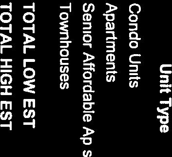
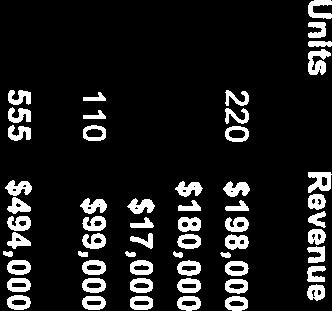
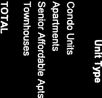
6 Rezoning Z and Special Use Permit SU Page 5 Table 3 provides a summary of the uses proposed in the submitted plan. Townhomes 110 Multifamily Apartment Units 200 Multifamily Condo Units 220 Senior Affordable Housing 25 Total Residential Units 555 Retail Area Community Area Total Non-Residential Area Table 3: Program Summary 10,000 sf 24,000 sf 34,000 sf REQUESTS In order to fully execute the aforementioned improvements, the applicant proposes the following land use requests for City Council action: Rezoning CR Commercial Retail, RM Residential Medium and John C Wood House Historic District to PDM - Planned Development Mixed Use; Special Use Permit to allow disturbance in the floodplain; and Comprehensive Plan Amendment to change the Future Land Use Map from Institutional to Mixed Use. These land use requests are subject to change based on further analysis by staff and design modifications to the proposal. ANALYSIS The purpose of the applicant s request for this work session is to gain feedback from the City Council and Planning Commission on the proposed development. Staff has conducted an initial review of the proposal and provided a comment letter to the applicant based on guidance from the Zoning Ordinance, Comprehensive Plan and other current City goals and policy. A summary of this review is provided in Attachment 1, organized into the following general categories: land use, scale, circulation, historic resources, natural resources and parks and open space. City Hall Armstrong Street Room 207 Fairfax Virginia (FAX)
7

8 ATTACHMENT 1. WORK SESSION ANALYSIS Land Use The existing school property is designated as Institutional on the Comprehensive Plan Future Land Use Map and the two single family parcels are designated as Residential Low as indicated in Figure 1-1A. The relocation of the existing school was not anticipated at the time that the current Comprehensive Plan was adopted. The applicant requests a Comprehensive Plan Amendment to change the designation of the site on the future land use map from Institutional and Residential Low to Mixed Use, as shown in Figure 1-1B in order to allow the proposed development to be reviewed based on the Comprehensive Plan Guidance for Mixed Use land use designations. Figure 1-1A: Future Land Use Figure 1-1B: Applicant s Proposed Future Land Use Page 1

9 With a location directly fronting onto Fairfax Boulevard, guidance for the site is further provided through the Fairfax Boulevard section of the land use chapter and by the Fairfax Boulevard Vision Summary as provided in Appendix D of the Comprehensive Plan. All areas along the Fairfax Boulevard corridor are either defined as Centers or Connectors with Centers being targeted for relatively higher intensity, pedestrian oriented development and Connectors targeted for more moderate intensity development with appropriate transitions to adjacent neighborhoods. This site is located in the West Connector generally encompassing the area between Kamp Washington and Chain Bridge Road, as shown in Figure 1-2. Figure 1-2: Site location along the Fairfax Boulevard corridor Although the site is not located in one of the Center specifically identified in the Comprehensive Plan, the applicant makes an argument in the Statement of Support that the subject property bears characteristics more similar to that of a center rather than a connector as described in the Comprehensive Plan primarily due to the depth and overall size of the site. Staff generally does not support this claim because the site is not adjacent to special intersections as identified in the Comprehensive Plan, which would provide access to more than one arterial, and because the site is not buffered from surrounding single-family residential neighborhoods, as most of the identified Centers are. While some flexibility should be afforded due to the overall size and depth of the site, staff review of the application is generally based on guidance from the Comprehensive Plan for connectors as opposed to centers, as cited below: Connectors: Connectors should take the form of a linear, aesthetically enhanced boulevard. Most of these areas do not have the proper depth or potential for unified, coordinated development. Their focus would be on lower scale buildings (predominantly 1 to 3 stories) with emphasis on accessibility, improvements in architectural and site design, and appropriate interface between the commercial boulevard and existing neighborhoods, such as appropriate land use transitions and green space buffers. [Comprehensive Plan page 169] Page 2
10 Future development along Fairfax Boulevard is primary envisioned as commercial in the Comprehensive Plan as stated below: Appropriate land uses along the corridor are primarily commercial, with opportunities for substantial levels of development in key areas. The mix and design of future development and redevelopment along the Fairfax Boulevard corridor should support the City s vision for its economic future and reflect the importance of this centrally located area within the region. [Comprehensive Plan page 169] The applicant s request for a Comprehensive Plan Amendment to change the designation for the site on the Comprehensive Plan Future Land Use Map from Institutional and Residential - Low to Mixed Use is not consistent with the recommendations for Connectors along the Fairfax Boulevard corridor as provided above. If an amendment from the current designation is supported, staff recommends the Future Land Use Map be amended in a manner generally consistent with the prevailing land use pattern in the adjacent area. Appropriate land use designations would include Business Commercial for areas closest to Fairfax Boulevard which is consistent with the designation of other properties in the connectors and would support smaller scale commercial uses. Stand-alone residential uses are not supported along the Fairfax Boulevard frontage. All other areas of the site should provide a land use designation to allow appropriate transitional uses, such as moderate density residential uses, between the commercial frontage along Fairfax Boulevard and existing residential neighborhoods. The Comprehensive Plan does provide guidance for situations where residential uses may be considered within the context of the Fairfax Boulevard Masterplan Vision as provided below: Component of Unified Mixed Use Project: The Future Land Use map identifies the three locations along the Boulevard where Mixed Use is identified as being appropriate. Those locations, or Centers (Fairfax Circle, Northfax, and Kamp Washington), are envisioned as being coordinated developments containing a mix of commercial, residential, and institutional uses. Often in such mixed use projects, a residential component is desirable in order to realize the full benefits of the commercial component. In such cases where a unified development is planned for one of the mixed use Centers shown on the Future Land Use map, a residential component may be considered as part of the development, and would be in concert with the tenets of the Fairfax Boulevard Master Plan Vision and Summary. Replacement of an Undesirable Use: Certain current land uses within the City are considered undesirable due to an unattractive appearance or other negative externalities. In cases where the elimination of an undesirable use can be considered of primary importance, consideration should be given to supporting residential as the primary land use. However, extreme care must be taken to ensure that residential uses complement the general commercial nature of the Fairfax Boulevard corridor [Comprehensive Plan pages ]. The site is not located in an area designated as a Center in the Comprehensive Plan and the existing school would not likely be considered an undesirable use as defined above. Despite this, the size of the site is unique among properties located within the Connectors along Fairfax Boulevard and the proposal as presented could be considered a unified mixed use project which may justify incorporation of residential uses. While staff believes that some flexibility should be afforded to the applicant due to the overall size and depth of the site, staff believes the submitted application should generally be reviewed based on Comprehensive Plan guidance for Connectors along the Fairfax Boulevard corridor, as opposed to Centers. Page 3
11 The applicant s proposal to amend the future land use map from Institutional and Residential Low to Mixed Use is not consistent with the recommendations for connectors along the Fairfax Boulevard corridor. Staff believes that any amendments to the Comprehensive Plan land use designation should be generally consistent with the prevailing land use pattern in the adjacent area. Appropriate land use designations on the Future Land Use Map should include Business-Commercial along Fairfax Boulevard and land use designations provided for all other areas of the site to allow appropriate transition between the commercial frontage along Fairfax Boulevard and existing residential neighborhoods. Staff seeks further discussion from the City Council and Planning Commission regarding the applicant request for an amendment to the Comprehensive Plan Future Land Use Map designation and appropriate land uses for the site. Scale Density: Although the Comprehensive Plan does not specifically recommended densities for the various types of potential uses along the Fairfax Boulevard Corridor, the descriptions for recommended building height locate the highest intensity uses within the three Centers with more moderate intensities would occuring within the Connectors. Since the incorporation of the Fairfax Boulevard Vision and Summary into the Comprehensive Plan, there have been two land use approvals for mixed-use/multifamily developments within Centers. No proposals for development with residential uses within Connectors have been approved to date. Other recently approved residential developments with multifamily components have had varying densities, reflective of their locations within the City. For the purpose of comparison, the overall residential densities for all recently approved multifamily residential development applications as compared to the subject proposal are provided in Table 1-1. Project Site Area Number of Units Residential Density/Acre Non- Residential Area Paul VI Redevelopment acres ,000 Fairfax Circle Plaza 9.18 acres ,000 Novus Fairfax Gateway 8.32 acres ,000 Mount Vineyard 6.11 acres The Enclave 3.76 acres Layton Hall 7.81 acres Table 1-1: Comparison of approved developments Comprehensive Plan Area Designation Fairfax Boulevard Connector Fairfax Boulevard Center Fairfax Boulevard Center Undesignated Main Street Undesignated Pickett Road Transition District Height: The submitted plan indicates building heights of up to five stories for the two multifamily buildings at the core of the site, and as low as two stories for the preserved or rebuilt portion of the school. Building heights for the townhomes are not presented in the plans. The proposed height of 4 to 5 stories conflicts with the Comprehensive Plan language cited on Page 6 of this memo which recommends 1 to 3 stories along Fairfax Boulevard Connectors. It should be noted that this height recommendation is based on typical commercial lot sizes along Fairfax Boulevard, which are somewhat smaller than the subject site. The zoning ordinance also permits a height of 5 stories or 60 feet in the CR Commercial Retail district, which is the predominant zoning classification for properties along the length of Fairfax Boulevard. Page 4
12 While staff believes that some flexibility should be afforded to the applicant due to the overall size and depth of the site, the building height recommendation of 1 to 3 stories in connectors should be strictly adhered to in areas of the site that are closer to existing single-family neighborhoods. Staff does not support the overall proposed density of dwelling units per acre as it does not allow for adequate transition to existing single-family neighborhoods adjacent to the site. Circulation Vehicular Network: Vehicular access is provided to the site through an existing access point from Oak Street and multiple access points along Fairfax Boulevard. No vehicular connections are proposed between the site and McLean Avenue, Cedar Avenue or Keith Avenue. With no vehicular access from the east, vehicular accessibility is not improved on that side of the site. In addition, the lack of any access points on that side of the site are in conflict with the requirements of the Subdivision Ordinance, which requires a maximum block length of 600 feet. The overall block length along McLean Avenue between Fairfax Boulevard and Cedar Avenue is over 1,100 feet. The block length between McLean Avenue and Oak Street along the southern property line is over 1,000 feet. Along Fairfax Boulevard, access is provided to the existing signalized intersection across from Boulevard Shopping Center (Petco). A Boulevard style slow-lane is provided along the length of the Fairfax Boulevard frontage for the site. The Comprehensive Plan suggests that slow lanes should be considered along Fairfax Boulevard in certain circumstances as stated below: Slow lanes (with on-street parking), separated from the main travel lanes by landscaped medians, while not intended to be a consistent feature throughout the corridor, they should be considered within or adjacent to portions of the Centers if the nature of adjacent redevelopment activity is such that those features would be appropriate [Comprehensive Plan, page 126]. Although the site is not located within an area designated as a Center, the size of the site and the nature of the development proposal lend themselves to inclusion of slow lanes. The benefit of slow lanes in this situation is that they allow for on-street parking that improves access to retail and provide a buffer between the streetscape, including open spaces on the site and traffic along Fairfax Boulevard. While the presence of a slow-lane is generally supported, staff has identified safety issues and impacts to signal timing that may need to be addressed through physical modifications to the design of the slow-lane. Staff believes the internal vehicular circulation network is generally in conformance with the Comprehensive Plan for development in Fairfax Boulevard Connectors with the exception of the lack of connection on the eastern side of the site. Further, the lack of a connection to McLean Avenue, Cedar Avenue and/or Keith Avenue is inconsistent with the requirements of the Subdivision Ordinance. Staff believes the incorporation of a slow lane along Fairfax Boulevard is in conformance with the Comprehensive Plan, provided that modifications are provided to address safety and circulation concerns. Pedestrian Network: With internal streets designed with narrow cross sections, on street parking, landscaping and other pedestrian amenities, the overall vehicular network in the proposed plan generally accommodates pedestrians as well. In addition, internal open spaces and mid-block pedestrian accessways provide additional connections for pedestrians, including direct connections to the street network east of the site. A shared use path is proposed along McLean Avenue as supported in the Comprehensive Plan trails map (page 89). The overall pedestrian network supports additional linkages between adjacent neighborhoods, open spaces and commercial areas as supported in Comprehensive Plan strategy T cited below: Page 5
13 T Examine roadway segments near schools, churches, parks, shopping areas, and neighborhoods to provide safe pedestrian routes. At appropriate locations along the City s streets, the provision of sidewalks, trails, pedestrian signals and crosswalks will help facilitate the safe travel of pedestrians. It is especially critical to connect residential areas with one another and with public facilities, businesses and services that residents need. [Comprehensive Plan, page 133] In general, pedestrian accessible accessways within the site create block faces that range from 200 feet to 500 feet in length. These dimensions are consistent with existing block lengths in Old Town Fairfax and at recently approved mixed-use developments at Fairfax Circle Plaza and Novus Fairfax Gateway and are considered appropriate for pedestrian oriented environments. Despite this, staff has requested that the applicant make some improvements to the pedestrian network, including the following: 1. Adjusting the trail along McLean Avenue to avoid forcing users on to the street at the ends and providing direct connections to McLean Avenue; 2. Adding a multi-use trail along Fairfax Boulevard; 3. Extending the proposed McLean Avenue trail west along Cedar Avenue; 4. Improving connections to Pat Rodio Park; 5. Providing a landscaped area between sidewalks and adjacent residential buildings where not provided. Staff believes the pedestrian network provided in the submitted plan is appropriate with some refinement, and encourages the applicant to continue to base the pedestrian network on the principles stated above as the plan is refined. Parking: Parking is provided through a combination of parking structures, on-street parallel spaces, individual garages and in some cases, small surface lots. The applicant proposes to meet the parking requirements of the Zoning Ordinance for the townhomes, commercial space and community space. They are requesting a modification to allow a reduction in the parking requirement of the multifamily uses (condominiums and apartments). Parking for all residential uses would be provided in shared or individual garages. Parking for all other uses is provided with parallel on-street spaces or in surface lots. The applicant proposes to provide 74 surface spaces in addition to those spaces that are counted toward the parking requirements. Approximately 50 of these spaces are identified on the plan for users of Pat Rodio Park. The overall proposed parking ratios are provided in the table below: Use Type Quantity Requirement Parking Parking Percent of Ratio Required Provided Requirement Multifamily Apartment 225 units 1.78/unit* % Multifamily Condominium 220 units 1.76/unit* % Townhomes 110 units 2.0/unit % Commercial Space 10,000 sf 1/200 sf % Community Space 24,000 sf 1/300 sf % Other Parking 0 74 NA Total 1,169 1,121 96% *Multifamily parking requirements are based on the number of bedrooms in each unit. See Table 1-3 for parking requirement calculations for multifamily units. Table 1-2: Proposed Parking Ratios Parking requirements for multifamily units are calculated based on the number of bedrooms in each unit with 1.5 spaces required for each one-bedroom unit and 2.0 spaces required for each two-bedroom unit. A Page 6
14 breakdown of the parking requirement calculations for multifamily units is provided in Table 1-3. A ratio of 1.6 parking spaces per unit has been approved for several recent multifamily developments within the City, including condominiums and townhomes, though no supporting data has been provided to confirm that this parking ratio would be sufficient to serve the multifamily uses in this application. Apartments Quantity of unit type Spaces per unit required Total Spaces Required for Unit Type 1 Bedroom Units Bedroom Units Senior Units (2 Bedroom) Total Total Provided Condominiums Quantity of unit type Spaces per unit required Total Spaces Required for Unit Type 1 Bedroom Units Bedroom Units Total Total Provided Table 1-3: Multifamily Parking Ratios Staff does not have enough information on parking quantities to provide a recommendation on requested parking reductions for multifamily uses at this time. Historic Resources Although there are no structures on the site that are currently included on the National Register of Historic Places, the site does include Paul VI High School (formerly Fairfax High School) and the John C. Wood House. The John C. Wood House is located within the John C. Wood House Historic Overlay District. Paul VI High School is not included within a historic overlay district as defined by the Zoning Ordinance. The original portion of Paul VI High School was constructed in 1935 and contains exemplary architectural elements of that time period. The Comprehensive Plan seeks further protection of these types of buildings through the following Historic Resources Strategy: HR-1.8 Seek National Register nomination of additional historic resources, as appropriate. The City should support individual property owners in seeking National Register designation for their properties. In addition, the City should initiate designation for publicly held properties, as appropriate. Examples of sites that may now or soon meet the designation criteria include Paul VI High School (formerly Fairfax High School), the Farr property, the Sisson House (currently used for School Board and Voter Registrar offices) on the City Hall grounds, and a potential residential historic district in the Fairfax Triangle area. [Comprehensive Plan page 114] The applicant proposes to retain and modify the original center portion of the high school for adaptive reuse (area shaded in Figure 1-3). Since construction of that portion of the building, multiple additions and modifications have occurred. It is anticipated that substantial restorative work and modifications would be required to the structure in order to preserve it. An adaptive reuse study and historic structures report on the Page 7

15 building by a qualified architect specializing in historic architecture has not yet been submitted. Such a report is required to ensure that the building could be modified without substantial alteration to the exterior integrity and would address whether the multiple additions to the building are contributing elements. Substantial alteration and demolition could result in the remaining portion of the building being ineligible for inclusion in the National Register of Historic Place. Figure 1-3: Building area proposed for preservation In the submitted Statement of Support, the applicant indicates that an understanding could be considered to allow the City to have control of the retained school building for an undetermined use, though the applicant does not propose to improve the interior of the building. The applicant has not proposed any alternative uses of the building should applicant and the City choose not to negotiate and enter into a formal agreement. The applicant proposes to demolish the John C. Wood House as a part of the submitted plan, and requests that the John C. Wood House Historic Overlay District be removed. This district was established by City Council in 2010 on the site of the former home of John C. Wood, the first Mayor of The City of Fairfax based on the following criteria: 1. The age of the building and its ties to the Cedar Avenue neighborhood, which is the oldest residential subdivision in the City; 2. The association with the honorable John C. Wood, a prominent local figure. Staff is not aware of any additional studies of the house that have been conducted since the overlay district was established in The overlay district places local protection on the property, which requires approval by the Board of Architectural Review or City Council for alteration or demolition of the building. The applicant has not submitted a historic structures report or any justification for removal of the district to date. The Comprehensive Plan does not provide guidance on the deletion of Historic Overlay Districts. Staff does not have enough information to assess the viability of the applicant s proposal to preserve the original portion of the school building. Staff does not support the applicant s proposal to demolish the John C. Wood House or remove the John C. Wood House Historic District based on the information that has been submitted to date. Page 8

16 Natural Resources: Stormwater: Much of the western portion of the site is located in the floodplain as shown in Figure 1-4. The City has recently constructed stormwater improvements project at the intersection of Fairfax Boulevard and Oak Street, which is located upstream from, but would have a minimal impact on the site. If the applicant intends to maximize development potential in this portion of the site, further improvements for the length of the stormwater pipe that runs along the western property line will be necessary in order to remove or reduce the floodplain on the site. The applicant intends to make such improvements in order to apply for and receive a Letter of Map Revision (LOMR) from FEMA to official modify the boundaries of the floodplain based on stormwater improvement on the site. The applicant has applied for a Special Use Permit for disturbance in the floodplain to allow them to make the improvements that would modify the floodplain boundary, as well as a Conditional Letter of Map Revision (CLOMR) from FEMA. Issuance of a CLOMR from FEMA is required before the Special Use Permit can be considered by City Council. Figure 1-4: Existing Floodplain Conditions The applicant intends to file a financing proposal regarding stormwater improvements on the subject site, including requests for monetary support from the City or reductions in utility tap fees based on the existing condition of the facility and the suggestions that improvements are needed to the drainage regardless of the subject application. Any financial commitment by the City would require separate action from City Council and would not be associated with land uses actions in the subject application. It should be noted that replacement of this structure has not been included in the City budget to date. In addition, a City sponsored improvement to such structures would not include adding capacity, which the applicant is dependent on to reduce the extent of the flood plain. Staff is awaiting a modified floodplain study from the applicant and issuance of a CLOMR from FEMA before providing a recommendation on the proposed modifications to the floodplain boundary and the Special Use Permit for disturbance in the floodplain. Page 9
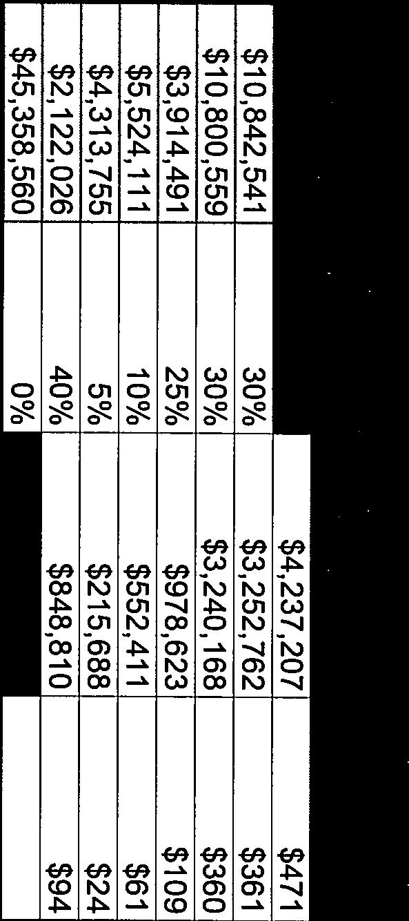
17 Tree Preservation: The following two environmental strategies from the Comprehensive Plan should be considered as the site design for this proposal is refined: ENV-1.1 Continue to enforce and refine the City s regulations that require new development to preserve existing natural features to the extent practical. Special protection is provided for trees, floodplains, and watersheds through zoning regulations. Although it is not possible to develop wooded property without removing trees, significant stands of trees should receive considerable attention in the development review process to ensure that all practical and reasonable attempts at preservation have been made. Through the review of development plans and in the process of negotiated rezoning, special use permit and special exception requests, the City can ensure that natural resources are protected. ENV-1.2 Encourage planned development that maximizes the retention of natural features. Conventional development often results in the destruction of a site s natural features. Sites are often completely denuded of tree cover, the topography is leveled, and streams are piped and covered. Planned developments, however, can be used to encourage buildings, roads and utilities to be arranged in clusters, resulting in the preservation of significant natural features. [Comprehensive Plan, page 33] The majority of the school site has been disturbed with buildings, parking and athletic fields, though the submitted tree survey indicates the presence of some significant trees along the periphery of the site and particularly on the two single family lots along Cedar Avenue that are included within the site. The applicant does not propose preservation of any existing trees on the site. Staff recommends that the site plan be revised to accommodate significant trees or stands of trees that can contribute toward aesthetic appeal, screening, shade, or other benefit to the site or surrounding community. Parks and Open Space: On-Site Open Space: The submitted plan provides a mixture of publicly accessible open spaces, private open spaces and linear open spaces along accessways and rights of way. The Fairfax Boulevard Master Plan Vision and Summary provided in Appendix D of the Comprehensive Plan particularly encourages the inclusion of new and enhanced public spaces and green buffer zones located between commercial lots and single family neighborhoods. For any of the Planned Development districts, as the application seeks to be rezoned, the Zoning Ordinance only considers usable open space which is defined based on certain parameters, to count toward open space requirements. The applicant submitted plan does not meet the minimum 20 percent open space area that is required for the site because areas used in that calculation do not meet the definition of usable open space as provided in the Zoning Ordinance. Staff estimates the area of the proposed plan that meets this definition encompasses just under 16 percent of the total site area. A summary of the applicant s calculation of open space compared to the staff calculation of open space is provided in Table 1-4. Page 10
18 Applicant Calculation Staff Calculation Total Site Area 806,332 sf 806,332 sf 20% Open Space 161,266 sf 161,266 sf Requirement Area Provided 240,000 sf 127,815 sf Percent Provided 30% 16% Numeric Difference 78,734-33,451 Table 1-4: Open Space Calculations Staff supports the general concept of a network of open spaces, including larger open space, linear open space and pocket parks, as included in the submitted plans, though the plan should be modified so that usable open space as defined in the Zoning Ordinance, covers at least 20% of the total site area. Page 11
19
20
21
22
23
24
25
26
27
28
29
30
31
32
33
34
35
36
37
38
39
40
41
42
43 APPLICATION OF IDI FAIRFAX, L.C. PAUL VI HIGH SCHOOL REDEVELOPMENT STATEMENT OF SUPPORT April 18, 2017 INTRODUCTION IDI Fairfax, L.C. ( Applicant or IDI ), as master developer for the Catholic Diocese of Arlington ( Owner or Diocese ), has submitted an application to rezone the existing Paul VI High School and two other properties (collectively, the Property ) owned by the Diocese, to the Planned Development Mixed Use ( PD-M ) zoning district to permit the redevelopment of the Property with a vibrant, mixed use community that provides distinctive, diverse and affordable housing options, generates significant fiscal benefits to the City, and preserves and respects the unique qualities and character of the neighborhood. The Property is located within the block bounded by Fairfax Boulevard, Oak Street, Cedar Avenue and McLean Avenue. It is a consolidation of three parcels for a total of acres. The parcels are located at Fairfax Boulevard (Paul VI High School, 16.1 acres), Cedar Avenue (1.15 acres) and Cedar Avenue (John C. Wood House, 1.25 acres). The Property s acres are currently split zoned with approximately 12.2 acres zoned Commercial Retail ( CR ) and approximately 6.3 acres zoned Residential Medium Density ( RM ). The current Comprehensive Plan Map designates the existing school for Institutional use and the residentially zoned parcels for Residential Low development. As part of this application, the Applicant is requesting an amendment to the Comprehensive Plan Map to change the designation of the Property to Mixed Use. PROPOSAL HISTORY In early 2015 the Diocese announced its intention to relocate Paul VI High School to a brand new facility located in Loudoun County. Soon thereafter, the Diocese selected the Applicant to be the master developer for the Property. The Applicant became responsible for creating a development plan for the Property and obtaining all necessary entitlements prior to the time of relocation of the school. The Diocese chose IDI as the master developer because of IDI s 40 year track record of developing some of the Washington metropolitan region s most innovative and successful mixed-use and residential projects. Throughout that time IDI has proven its ability to work collaboratively with diverse constituencies while building relationships and trust among stakeholders during entitlement processes. Specifically, IDI has developed 27 mixed-use projects and residential communities in the Washington Metropolitan area comprising over 13,000 multifamily condominium and rental apartment units, 2.7 million square feet of commercial development and over 1,400 hotel rooms. IDI became the leading and largest developer of condominium communities in the Metropolitan Washington area, creating such landmarks as Porto Vecchio and Carlyle Towers in Alexandria, Belvedere in Arlington, and the / v.2 1 P a g e
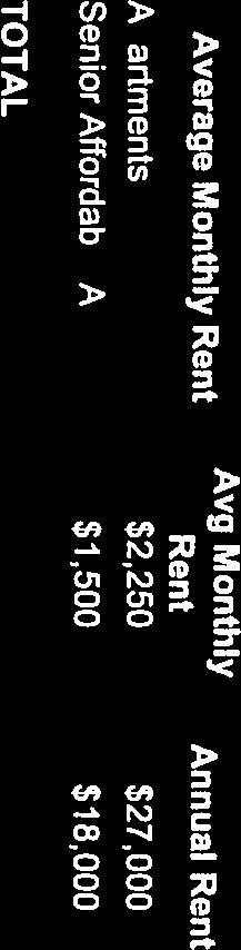
44 Rotonda in Tysons Corner. IDI also pioneered the development of active adult living with the Leisure World communities in Maryland and Virginia, and is an industry leader with its conversion of over 3,000 high-rise and garden units into workforce affordable homes. In September of 2015, IDI received approval from the City of Fairfax to develop The Enclave, a residential condominium community at the Mantua Professional Center off of Pickett Road. The Enclave is currently under construction and, upon completion later this year, will consist of 80 high quality condominium homes in two four-story buildings with garage parking. The redevelopment of the Property will commence after the school has completely relocated to its new location. This is expected to occur during the summer months of 2019 (after the school year). After its selection by the Diocese as master developer, the Applicant began a series of stakeholder and community meetings in October, 2015 to introduce themselves and to gather community input on what type of redevelopment would be appropriate to address the City s needs and the community s desires. To date, almost 50 of these meetings have taken place, including three large scale community meetings conducted in February 2016, March 2016 and October A Joint Work Session with the City Council and the Planning Commission was held on September 6, 2016 at which time the Applicant presented two alternative concepts for consideration and input. As a result of these meetings, a productive partnership was formed between the Applicant, City officials, and affected stakeholders, and the Applicant is pleased to put forward a single plan of development that addresses and balances the diverse opinions expressed during the stakeholder and community meetings. PROJECT DESCRIPTION The project is intended to create a welcoming, vibrant, and attractive community containing neighborhood places of all types. As such, the Applicant proposes to replace the existing school use and single family homes with a mixture of residential, commercial and community uses; open the property up for public use; preserve the original Fairfax High School building; and modify existing traffic patterns to reduce the impact on the surrounding neighborhoods. The breakdown of specific uses is as follows: Description of Use Townhomes Multifamily Condominium Units Multifamily Apartment (Rental) Units Affordable Senior Housing Units Commercial/Retail Space Community Space Density 110 dwelling units 220 dwelling units 200 dwelling units 25 dwelling units 10,000 square feet 24,000 square feet Total 555 dwelling units (29.9 du/ac) and 34,000 SF of Retail and Community Use 2 P a g e / v.2
45 An illustrative site plan of the project is shown below. Key features of this plan include: The preservation of the original portion of the school building that was constructed in 1935 so that it may be adaptively reused as part of the project. Vehicular access through multiple access points along Fairfax Boulevard, including an existing signalized intersection directly across from the Boulevard Shopping Center, and from an existing access point from Oak Street. No vehicular connections are proposed between the Property and McLean Avenue, Cedar Avenue and Keith Avenue. Pursuant to the Comprehensive Plan, inclusion of a boulevard style slow-lane along the entire length of the Fairfax Boulevard frontage. The slow-lane will be one-way eastbound and allows for on-street parking that will benefit the proposed retail and community uses. Creation of a pedestrian network through the Property that is currently closed off to the public. A shared use path is also proposed along McLean Avenue in conformance with the City s Comprehensive Plan trails map. Preservation of the large green open area in front of the school entrance and the provision of numerous vest pocket parks open to the public, which contribute to overall open space within the project of more than 5.5 acres. Retention of community accessible parking spaces for City residents using Pat Rodio Park. Setbacks along McLean Avenue and Cedar Avenue consistent with the existing setbacks provided by the residences. Removal or reduction of the floodplain along the western property line of the Property that will benefit the community further downstream. Provide an opportunity for the City to program the use of the original school building, and ultimately acquire ownership or control of the building if the City so desires. 3 P a g e / v.2
 RECREATION AND OPEN SPACE: ±30% PERIMETER BUFFER: Modification requested (See Sheet 1, Note 17.1 of the development plans) STREET TREES: Modification requested (See Sheet 1, Note 17.")
46 Specific development tabulations for the project (as depicted on the development plans) are summarized below: SUBJECT AREA (GROSS): 806,332 SF (±18.51 AC) RECREATION AND OPEN SPACE: ±30% PERIMETER BUFFER: Modification requested (See Sheet 1, Note 17.1 of the development plans) STREET TREES: Modification requested (See Sheet 1, Note 17.2 of the development plans) TREE CANOPY: ±10% BUILDING HEIGHT: Up to 5 Stories / v.2 4 P a g e
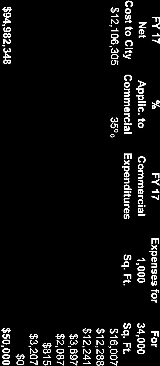
47 PARKING TABULATIONS: Use Units/SF Required Rate Modified Rate Per Requested Modifications Townhomes per unit = 220 Condominium 44 One Bedroom Units 176 Two Bedroom Units spaces 1.5 per unit = 66 spaces 2 per unit = 352 spaces 1.6 per unit = 352 spaces Proposed to be Provided 220 garage spaces 352 total garage spaces Apartments Senior Affordable Apartments 98 One Bedroom Units 1.5 per unit = 147 spaces 102 Two 2 per unit = 204 Bedroom Units spaces 25 units 2 per unit = 50 spaces Retail 10,000 SF 1 per 200 SF = 50 spaces Community 24,000 SF 1 per 300 SF = 80 spaces Pat Rodio Park Additional Surface Spaces Total Parking 1,169 required spaces 1.6 per unit = 320 spaces 1 per unit = 25 spaces 1,047 required spaces if modifications are approved (approx. 10.4% reduction) 345 total garage spaces (included in Apartments 345 space garage noted above) 50 surface spaces 80 surface spaces 50 surface parking spaces (9 of which are located off-site on City-owned property and are subject to Council approval) 33 surface spaces 1,130 provided parking spaces (includes the 9 off-site spaces) (approx. 3.3% reduction) 5 P a g e / v.2
48 The Applicant intends to develop design guidelines for the Property with respect to building scale and massing, building siting, screening and dimensional standards, the design of the open space and pocket park areas, and streetscape so that the buildings and improvements have a high quality and complimentary design theme. The details of the guidelines will be produced during the processing of the application. SUPERIOR COMMUNITY BENEFITS TO THE CITY The proposed development will offer numerous community benefits to a much greater degree than would result from the current use or from by right development under the existing zoning. With approximately two-thirds of the Property currently zoned Commercial Retail (CR) (and without any proffered development conditions), by right development would consist of a large shopping center and one or more 5-story offices buildings with buildings significantly set back from Fairfax Boulevard, large areas of surface parking, and isolated from other development. Uses under such a scenario, in addition to general retail and office, include building supply stores, lumber yards, convenience stores, funeral homes and tobacco shops. Under the Planned Development zoning, and in addition to the project s key features listed above, the proposed development would offer the following greater benefits: Variety of housing types including predominantly owner occupied townhomes and condominiums, and market rate and affordable senior housing rental apartments. Condominium units will fill a significant demand from the move down senior market and first time home buyers that desire to remain in the City. Apartment units to meet the demand established by the City years ago for rental units in the corridor. Despite approval of other projects at two of the so-called Centers of the Boulevard, no such units have been delivered, or are even under construction. Affordable independent living dwelling units specifically designated for seniors. No other project in the City has offered this type of unit. In addition, both the condominium units and the townhomes will be attractive housing options for the City s seniors, including features marketed towards seniors that want to remain in the community such as an option for an elevator in the townhouses. Marketing data from IDI condominiums indicate that approximately 143 of the project s condominium units will be purchased by move down senior buyers. Overall, promotion of housing options that may not qualify as ADU s, but which are still affordable to existing and future residents so that they may age in place in the City. Development of compatible townhomes on the periphery of the Property adjacent to existing single family housing in terms of size, height, and design. All of the project s new residents will patronize the City s existing and future restaurant and retail businesses, and make the Fairfax Boulevard more competitive with mixed-use projects outside of the City. 6 P a g e / v.2
49 The project will generate fewer AM commuter peak hour trips and fewer PM school peak hour trips than the existing high school use. There will be more PM commuter peak hour trips than currently generated by the school. Overall future traffic impact will not change the level of service at the key intersections abutting the Property. Implementation of numerous smart growth measures, as recommended and endorsed by the Fairfax City Citizens for Smarter Growth. Establishment of a multi-modal transportation system. Significant positive financial impact, as described in the Fiscal Impact Analysis submitted as part of this application. Master developer with over 40 years of experience and a first class reputation to oversee the development to ensure it is created as a unified, cohesive environment. Upgrade public infrastructure serving the Property in the form of a grid of streets, available public parking, floodplain improvements to manage the watershed both on-site and off-site, provision of public open space and bike lanes, or improved vehicular access and circulation patterns. Established of proffered development conditions to mitigate the impact of the development. COMPREHENSIVE PLAN CONSISTENCY AND CONFORMANCE As proposed, the Applicant believes the project is in harmony with the guidance from the City s Comprehensive Plan, including the Fairfax Boulevard Vision Summary. As noted in the First Principles of the Plan contained as Appendix D in the Comprehensive Plan, the vision and plan for Fairfax Boulevard needs to be a living document that grows in response to changes in the City and region. The relocation of the current school use out of the City is an event that requires such a change. At the time the Fairfax Boulevard planning efforts were being performed in 2007, there was never any consideration that the Diocese might relocate Paul VI from its current campus. Therefore, although the Property was the largest single parcel of land along the Boulevard, the designation for Institutional use was not contemplated for change. In fact, nowhere in the City s Comprehensive Plan is there reference to a possible change of the existing use. The change in circumstances resulting from the School s decision in 2015 to relocate to a larger location outside of the City offers a unique opportunity. The Property is approximately 18.5 acres, two-thirds of which is zoned CR Commercial (without proffers or other land restrictions). The site is fortunate in that it is very deep, flat and has existing access to several public roads. Therefore, the characteristics are much more similar to that of the so-called Centers in the Comprehensive Plan than that of the Corridors, and as such are more consistent with the features defining a Unified Mixed Use Project in the Plan. These characteristics include: / v.2 7 P a g e
50 Large land area (approximately twice the size of the Fairfax Circle and Kamp Washington redevelopments approved by the City at a much higher density, but not yet under construction). Depth away from Fairfax Boulevard (not linear) such that the property is sized to achieve a unified, cohesive and coordinated development of an urban street character with town blocks, rather than a strip retail character. Streetscape and Boulevard improvements such as a landscaped median along Fairfax Boulevard, provision of a slow local lane with on-street parking, pedestrian sidewalks and other features both inside the development and along its boundaries. Proposed building heights of between 2 and 5 stories with potential for step up transitions and tapering. These heights conform to the current Zoning Ordinance requirements for the CR zone. Ability to provide a variety of pedestrian friendly travel options, including sidewalks and a trail that conforms to the City s trails plan. A network of small parks and public spaces, whereas the Property is currently not open to the neighborhood or general public. Overall, the size of the Property is unique among all of the other properties located in the West Connector along Fairfax Boulevard and the project as presented should be considered a Unified Mixed Use Project which justifies the wide variety of proposed housing types. The Applicant s plan conforms to or is in harmony with the Fairfax Boulevard Vision Summary s goals and objectives of transforming the Boulevard into a multi-modal and safer place, encouraging new development that is appropriately sized and scaled containing a mixture of uses including community and green spaces, and having an urban street character. The Applicant s proposal is best suited for a mixed use, place-oriented development - similar to projects in Reston Town Center, Pentagon Row and Clarendon and not a typical suburban strip center. Development of the Property as a Corridor would inevitably lead to a large strip shopping center and office development with one or more big box users, similar to what is already across Fairfax Boulevard from the school and typical of the type of oversaturated existing commercial retail/office development described by the City s consultant in its recent Market Analysis. Such a scheme would lead to buildings set back far from the Boulevard, open parking areas, and isolation from the community. The end result under either scenario would not meet the Plan s goals and objectives for a vibrant, walkable development that would revitalize the Boulevard. The proposal also conforms to the City s Comprehensive Plan objectives in regard to community appearance, recognizing historic or important buildings, transportation, land use and the promotion of economic development / v.2 8 P a g e
51 COMPREHENSIVE PLAN MAP AMENDMENT In order to proceed with the proposed redevelopment, the Owner and the Applicant request the City Council and the Planning Commission to amend the Comprehensive Plan Land Use Map to change the designation of the Property from Institutional and Residential to Mixed Use. While the Comprehensive Plan s legal status is advisory only and serves merely as a guide in the zoning decision making process, an amendment to the map is appropriate in this instance because the Owner has no intention of retaining the Property for institutional uses. Paul VI High School s relocation out of the City constitutes a sufficient change in circumstances to justify the amendment. REMOVAL OF HISTORIC OVERLAY DISTRICT DESIGNATION As part of this application, the Applicant respectfully requests that the City Council rezone Cedar Avenue to remove the historic district overlay designation from this parcel. This overlay district was established by the City Council in 2010 because the site is the former home the John C. Wood, the first Mayor of the City. At the time of adoption, the designation was not supported by either the Diocese or the Planning Commission. The Diocese stated that the home was in poor condition, subject to vandalism, and that it could be used as part of the Diocese s educational mission. Certainly Planning Commissioners stated that the property had never been the subject to any discussion about being historic until the Diocese applied for a demolition permit, and that there were other residences in the neighborhood of similar age and size such that the proposed designation amounted to spot zoning. While there are no specific criteria or processes in the Zoning Ordinance for the removal of a historic district designation, the Applicant intends to investigate the condition of the structure and will provide a report at a later date describing whether there has been any change in condition of the structure since the district was established in SPECIAL USE PERMIT The Applicant is requesting a Special Use Permit to permit a modification to the floodplain for the following reasons. First, the FEMA floodplain was not a studied floodplain, but rather an assumption of the maximum depth of water. As a result, the Applicant s engineer has prepared a detailed study that clearly and adequately depicts the existing FEMA floodplain. Second, the existing stormwater pipe located under the western boundary of the Property is a City of Fairfax stormwater facility located in a City easement. The Applicant and the City s engineers concur that the existing stormwater pipe is inadequate, and in its current condition is failing and causing upstream flooding. The City of Fairfax is obligated to maintain and repair the existing stormwater pipe. Such work, the need for which is not generated by the current and proposed uses on the Property, would be in accordance with the City of Fairfax Capital Improvement Plan ( CIP ). The Applicant is proposing to advance the costs to upgrade the stormwater pipe as part of the development of its project and thereafter to be reimbursed by the City for all costs properly allocated to the City in connection with its ongoing maintenance / v.2 9 P a g e
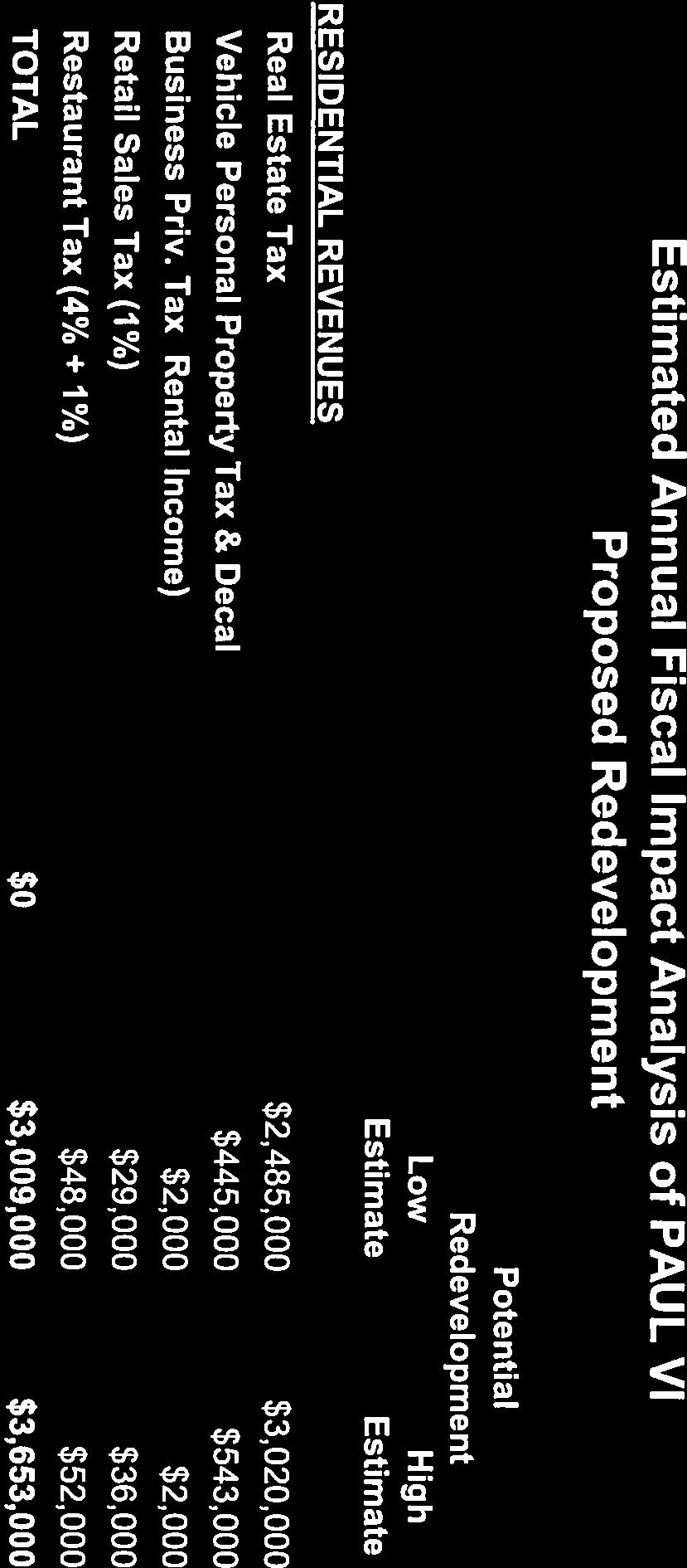
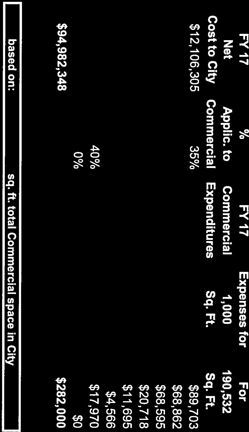
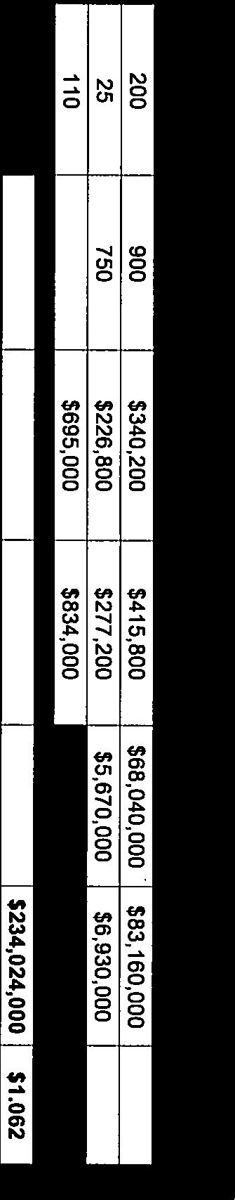
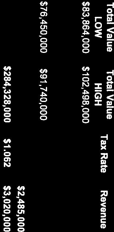
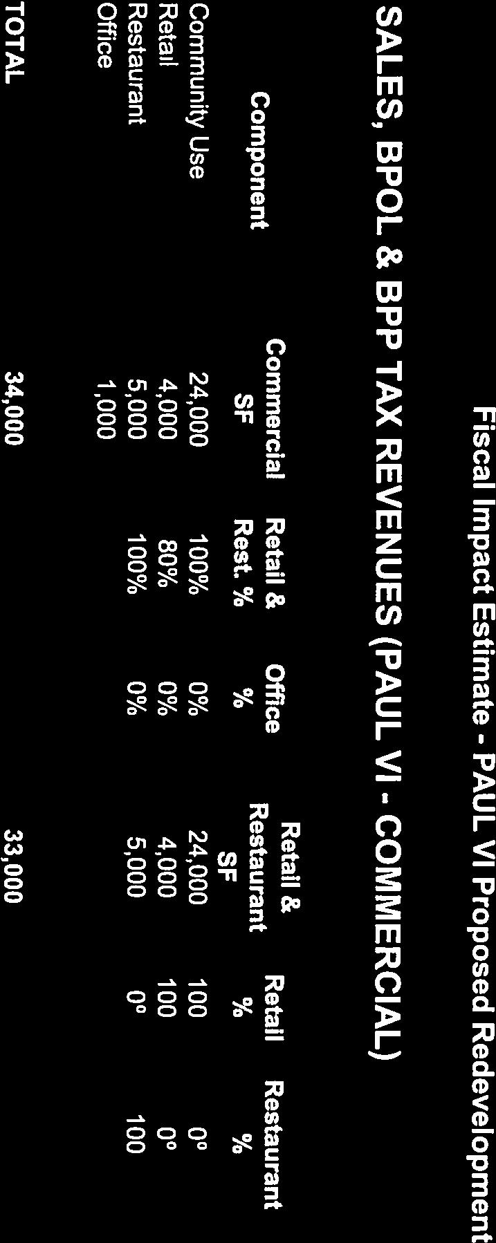
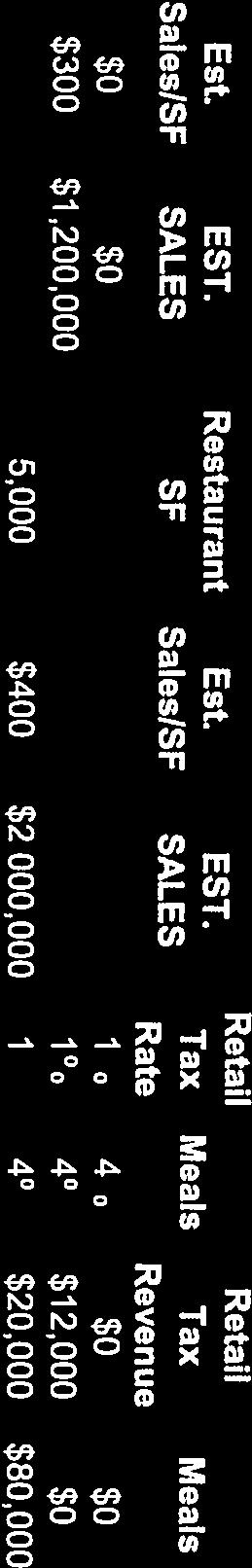
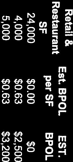
52 obligations of this stormwater facility. Therefore, a Special Use Permit is required to modify and disturb the floodplain in order to fix and upgrade the existing piping. MODIFICATIONS The Applicant requests the following modifications to the Zoning Ordinance requirements in order to implement the development plan: A. Project Boundary Transitional Yards. A modification is requested of the buffer transitional yard known as Transitional Yard 3 or TY3, as required by Section C.2 of the Zoning Ordinance, along the western property line. The requirement for TY3 is a 15 foot wide buffer area, with a 6 foot tall fence and a variety of trees and shrubs. Because the Applicant is providing a 30 foot wide drainage easement and the existence of floodplain in this area, only a 6 foot wide landscape area remains, but this is sufficient for landscaping. The Applicant proposes to add more shrubs than the amount required to compensate for the few trees that could not be planted. The Applicant meets the requirement for a 6 foot tall fence. Additional landscaping will be provided over the drainage easement area, including shrubs of various heights. B. Buffer Width. A modification of the 10 foot buffer width required pursuant to Section B of the Zoning Ordinance is requested along McLean Avenue to permit an 8 foot width. The Applicant believes an 8 foot wide buffer area is sufficient to meet the tree quantity requirement for street trees. In addition to the buffer, the Applicant is creating a pedestrian and bike friendly experience along McLean Avenue by providing a bike path and a sidewalk. C. Parking Space Requirement. A modification of the parking requirement for multifamily dwelling units. Pursuant to Section E of the Zoning Ordinance, 1.5 spaces are required for studio and one bedroom units and 2 spaces are required for two bedroom or more units. The Applicant proposes to provide 1.6 parking spaces per dwelling unit. Based on the Applicant s own historical marketing data gained from developing similar multifamily projects over the past 40 years, the proposed rate will be sufficient to meet resident demand. Further, the City Planning Staff and City Council have previously supported this rate for similar approved projects within the City, including the Applicant s Enclave development. FISCAL IMPACT The existing use of the Property as a private school does not generate any fiscal benefit to the City because no revenue is raised in the form of real estate taxes, personal property taxes, retail and restaurant sales taxes, and business, professional, and occupational license (BPOL) taxes. Based on the Applicant s Fiscal Impact Analysis, the impact of the present condition is that it costs the City approximately $282,000 to provide government services to the Property. Therefore, the existing situation is an annual drain on the City s budget and economy. Using the City s own methodology of studying the fiscal impact of a project, the Applicant s Fiscal Impact Analysis demonstrates that the proposed redevelopment reverses the situation and the project will generate an annual positive net benefit of between approximately $904,000 and $1,876,000 annually to the City. Please see the Applicant s Fiscal Impact / v.2 10 P a g e
53 Analysis, submitted as part of this application, for more information about the positive economic benefits of the redevelopment to the City. PROFFERS The Applicant and Owner intend to voluntarily proffer reasonable conditions governing the use of the Property if the application is approved. The proffers will be in compliance with law, will relate to issues that arise as a result of the rezoning, and will mitigate in proportion to the impacts they seek to address. The Applicant intends to draft the proffers and submit them to the City for review after receiving the Planning Staff s initial comments to the plans and other development details. PHASING SCHEDULE A phasing schedule has not been firmly established at this time. The existing school will not vacate the Property until mid-2019 at the earliest. The proposed development will likely commence immediately thereafter, provided all required site and building plan approvals have been secured. Subject to market conditions, construction will be accomplished in one continuous phase. SUMMARY The Applicant has carefully planned the Property and the project to strengthen the Fairfax Boulevard corridor, while respecting the existing neighborhoods. The development plan calls for a vibrant, attractive mixed use active community with generally low/medium building heights tapering to adjacent residences. A range of new housing options will be offered that are affordable, and will serve all ages to meet the housing needs of families, students, and older adults who wish to stay in place in the City. The project will encourage and support historic preservation, and will support preservation of the original Fairfax High School building, while also offering opportunities for increasing public understanding and appreciation for the Property's architectural and cultural history. Improvements to the transportation system on site will open the Property to the public and enable safe access for all users, including pedestrians, bicyclists, transit riders, and motorists of all ages / v.2 11 P a g e


54

55


56


57

58


59

60
61

62 Table of Contents Floodplain Study Narrative Appendix A Drainage Area Map and Hydrologic Calculations Appendix B Floodplain Map and Site Plan Appendix C HECRAS Model Existing Conditions Appendix D HECRAS Model Proposed Conditions
City of Fairfax, Virginia City Council Work Session
 City of Fairfax, Virginia City Council Work Session Agenda Item # 12a City Council Meeting 5/8/2018 TO: FROM: SUBJECT: Honorable Mayor and Members of City Council Robert Sisson, City Manager Request of
City of Fairfax, Virginia City Council Work Session
 City of Fairfax, Virginia City Council Work Session Agenda Item # WS 2 City Council Meeting 7/5/2016 TO: FROM: SUBJECT: Honorable Mayor and Members of City Council Robert Sisson, City Manager Request of
Staff Report to the North Ogden City Planning Commission
 Staff Report to the North Ogden City Planning Commission SYNOPSIS / APPLICATION INFORMATION Application Request: Concept review on a legislative application to rezone land located at approximately 1750
Jason D. Sutphin, Community Development Division Chief. Through: Brooke Hardin, Director of Community Development and Planning
 Meeting Date: 12/18/2017 Agenda Item: 9a. MEMORANDUM To: Chairman Cunningham and Members of the Planning Commission From: Jason D. Sutphin, Community Development Division Chief Through: Brooke Hardin,
ARLINGTON COUNTY, VIRGINIA
 ARLINGTON COUNTY, VIRGINIA County Board Agenda Item Meeting October 15, 2005 DATE: September 28, 2005 SUBJECT: Request to Advertise the adoption of the 2005 Clarendon Sector Plan C. M. RECOMMENDATION:
EXISTING COMPREHENSIVE PLAN
 EXISTING COMPREHENSIVE PLAN Town Center Land Use Element: V. LAND USE POLICIES Town Center Mercer Island's business district vision as described in "Your Mercer Island Citizen-Designed Downtown" was an
Policies and Code Intent Sections Related to Town Center
 Policies and Code Intent Sections Related to Town Center The Town Center Vision is scattered throughout the Comprehensive Plan, development code and the 1994 Town Center Plan. What follows are sections
AWH REPORT OF THE PLANNING AND DEVELOPMENT DEPARTMENT FOR APPLICATION FOR REZONING ORDINANCE TO PLANNED UNIT DEVELOPMENT
 AWH REPORT OF THE PLANNING AND DEVELOPMENT DEPARTMENT FOR APPLICATION FOR REZONING ORDINANCE TO PLANNED UNIT DEVELOPMENT MAY 8, 2014 The Planning and Development Department hereby forwards to the Planning
2.7 ac park. TOTAL 5,403 DU 1,297,900 sf 1,105,450 sf 3.87 ac 5,563 DU 1,121,200 sf 1,105,450 sf 3.87 ac
 PLAN AMENDMENT 2013-I-B1: SEVEN CORNERS SPECIAL STUDY Summary of Pre-staffing Comments Planner: Bernard Suchicital bsuchi@fairfaxcounty.gov (703) 324-1254 Background On October 29, 2013, the Board of Supervisors
2.0 AREA PLANS. Lakeside Business District. Lakeside Business District Land Use Categories:
 Lakeside Business District Lakeside Business District Land Use Categories: Campus Commercial Campus Commercial means a mixture of uses which includes corporate offices, office parks, hotels, commercial,
ARLINGTON COUNTY, VIRGINIA
 ARLINGTON COUNTY, VIRGINIA County Board Agenda Item Meeting of July 21, 2012 DATE: July 12, 2012 SUBJECT: SP #416 SITE PLAN AMENDMENT to modify condition #6 to eliminate requirement to provide a pedestrian
Dear Chairman Cunningham and Members of the Planning Commission:
 March 29, 2018 Planning Commission City of Fairfax 10455 Armstrong Street Fairfax, VA 22030 Dear Chairman Cunningham and Members of the Planning Commission: We are writing in regard to the application
Gold Line Bus Rapid Transit Transit Oriented Development (BRTOD) Helmo Station Area Plan
 Helmo Station Area Plan") Appendix F Gold Line Bus Rapid Transit Transit Oriented Development (BRTOD) Helmo Station Area Plan Introduction and Purpose of the Plan The Gold Line Bus Rapid Transit facility is an eleven-mile dedicated
Appendix F Gold Line Bus Rapid Transit Transit Oriented Development (BRTOD) Helmo Station Area Plan Introduction and Purpose of the Plan The Gold Line Bus Rapid Transit facility is an eleven-mile dedicated
ARTICLE 6: Special and Planned Development Districts
 ARTICLE 6: Special and Planned Development Districts 6-10 Traditional Neighborhood Development (TND) District 6-10.10 Purpose and Intent The Traditional Neighborhood Development (TND) District provides
SDOT DPD. SDOT Director s Rule DPD Director s Rule DCLU DR SED DR of 7 CITY OF SEATTLE
 SDOT SDOT Director s Rule 2-07 DPD Applicant: CITY OF SEATTLE Page 1 of 7 Supersedes: DCLU DR 11-93 SED DR 93-4 Seattle Department of Transportation (SDOT) Department of Planning and Development (DPD)
2136 & 2148 Trafalgar Road Town of Oakville Region of Halton
 PLANNING JUSTIFICATION REPORT 2136 & 2148 Trafalgar Road Town of Oakville Region of Halton Zoning By-Law Amendment Application 2500674 Ontario Inc. November 2016 Table of Contents Page 1.0 Location/Summary
4.1.3 LAND USE CATEGORIES
 4.1.3 LAND USE CATEGORIES a. City Center District The City Center District incorporates the existing character and mix of uses in downtown Belmont to encourage redevelopment and new development in keeping
Silver Line CPAM UPDATE. Transportation and Land Use Committee October 14, 2016
 Silver Line CPAM UPDATE Transportation and Land Use Committee October 14, 2016 Purpose Recap Project History and Map Changes Provide Overview of CPAM Components Discuss Transportation Impacts Discuss Fiscal
MONTGOMERY COUNTY PLANNING DEPARTMENT
 MONTGOMERY COUNTY PLANNING DEPARTMENT THE MARYLAND-NATIONAL CAPITAL PARK AND PLANNING COMMISSION MCPB Item No.: Date: 5-03-18 Pike and Rose, Phase I: Site Plan Amendment No. 82012002D Rhoda Hersson-Ringskog,
URBAN DESIGN BRIEF. 2136&2148 Trafalgar Road. Town of Oakville
 URBAN DESIGN BRIEF 2136&2148 Trafalgar Road Town of Oakville Prepared By: METROPOLITAN CONSULTING INC For 2500674 Ontario Inc November 2016 TABLE OF CONTENTS Page No. 1.0 Introduction/Description of Subject
12 January 12, 2011 Public Hearing APPLICANT: TAILWIND DEVELOPMENT GROUP,LLC PROPERTY OWNER: CITY OF VIRGINIA BEACH
 12 January 12, 2011 Public Hearing APPLICANT: TAILWIND DEVELOPMENT GROUP,LLC PROPERTY OWNER: CITY OF VIRGINIA BEACH STAFF PLANNER: Faith Christie REQUEST: Conditional Change of Zoning (from PD-H1 Planned
ARLINGTON COUNTY, VIRGINIA
 ARLINGTON COUNTY, VIRGINIA County Board Agenda Item Meeting of April 23, 2019 DATE: April 12, 2019 SUBJECT: SP #413 SITE PLAN AMENDMENT to permit a fixed bar in a private outdoor café space with associated
The Ritz-Carlton, Paradise Valley
 The Ritz-Carlton, Paradise Valley 7000 E. Lincoln Drive Keys to Success Community Conversation II June 4, 2015 RITZ-CARLTON PARADISE VALLEY Town Council Study Session June 4, 2015 General Plan 2012 Land
VICTORIA DOWNTOWN DEVELOPMENT PLANNING
 VICTORIA DOWNTOWN DEVELOPMENT PLANNING A Vision & Guide for the Future Downtown Victoria thrives as a center for the community, offering a great mix of entertainment, culture, business, and recreational
Request Conditional Rezoning (R-15 Residential to Conditional A-24 Apartment) Staff Recommendation Approval. Staff Planner Jimmy McNamara
 Staff Recommendation Approval. Staff Planner Jimmy McNamara") Applicant Franklin Johnston Group Management & Development, LLC Property Owner Virginia Wesleyan College Public Hearing July 12, 2017 City Council Election District Bayside Agenda Item 3 Request Conditional
Applicant Franklin Johnston Group Management & Development, LLC Property Owner Virginia Wesleyan College Public Hearing July 12, 2017 City Council Election District Bayside Agenda Item 3 Request Conditional
Agenda Item. Applicant Logan Virginia Properties, LLC Property Owners Byler Azalea, LLC & Gateway Free Will Baptist Chuch
 Applicant Property Owners Byler Azalea, LLC & Gateway Free Will Baptist Chuch Public Hearing March 14, 2018 City Council Election District Kempsville Agenda Item 6 Request Conditional Rezoning (B-2 Community
C. Westerly Creek Village & The Montview Corridor
 C. Westerly Creek Village & The VISION Community Vision When the goals of the city are achieved Westerly Creek Village, a distinctive community defined by Montview Boulevard and Westerly Creek, is a strong
I539. Smales 2 Precinct
 I539. Smales 2 Precinct I539.1. Precinct Description The Smales 2 Precinct applies to a 4.8 hectare block of land located on the southern side of Northcote Road and fronting Lake Pupuke, Takapuna. The
EXHIBIT A. Tax Increment Reinvestment Zone No. 1 (Town Center) First Amended Project Plan 1
 First Amended Project Plan 1") EXHIBIT A Tax Increment Reinvestment Zone No. 1 (Town Center) First Amended Project Plan 1 1 As amended by Resolution No. 2008-02-001(TR1R) of the Tax Increment Reinvestment Zone No.1, and approved to
EXHIBIT A Tax Increment Reinvestment Zone No. 1 (Town Center) First Amended Project Plan 1 1 As amended by Resolution No. 2008-02-001(TR1R) of the Tax Increment Reinvestment Zone No.1, and approved to
PINE CURVE REZONING. BACKGROUND Purchased as two parcels in 2001 and 2002
 BACKGROUND Purchased as two parcels in 2001 and 2002 WHAT THE PROJECT IS AND IS NOT A Rezoning establishes the land use standards for Annexed and Zoned Greater Downtown District Historic Center September
Planned Development Review Revisions (Project No. PLNPCM )
") Planned Development Review Revisions (Project No. PLNPCM2014-00139) Standard residential development Planned Development Example: Smaller lot sizes than what is allowed to create open space amenity. What
Planned Development Review Revisions (Project No. PLNPCM2014-00139) Standard residential development Planned Development Example: Smaller lot sizes than what is allowed to create open space amenity. What
The transportation system in a community is an
 7 TRANSPORTATION The transportation system in a community is an important factor contributing to the quality of life of the residents. Without a sound transportation system to bring both goods and patrons
Bloor St. W. Rezoning - Preliminary Report
 STAFF REPORT ACTION REQUIRED 1638-1644 Bloor St. W. Rezoning - Preliminary Report Date: April 1, 2008 To: From: Wards: Reference Number: Toronto and East York Community Council Acting Director, Community
FORMER CANADIAN FORCES BASE (CFB) ROCKCLIFFE SECONDARY PLAN. Official Plan Amendment XX to the Official Plan for the City of Ottawa
 ROCKCLIFFE SECONDARY PLAN. Official Plan Amendment XX to the Official Plan for the City of Ottawa") FORMER CANADIAN FORCES BASE (CFB) ROCKCLIFFE SECONDARY PLAN Official Plan Amendment XX to the Official Plan for the City of Ottawa 1 INDEX THE STATEMENT OF COMPONENTS PART A THE PREAMBLE PAGE Purpose...
FORMER CANADIAN FORCES BASE (CFB) ROCKCLIFFE SECONDARY PLAN Official Plan Amendment XX to the Official Plan for the City of Ottawa 1 INDEX THE STATEMENT OF COMPONENTS PART A THE PREAMBLE PAGE Purpose...
MONTGOMERY COUNTY PLANNING DEPARTMENT THE MARYLAND-NATIONAL CAPITAL PARK AND PLANNING COMMISSION
 MONTGOMERY COUNTY PLANNING DEPARTMENT THE MARYLAND-NATIONAL CAPITAL PARK AND PLANNING COMMISSION MCPB Item No. Date: 3.10.2016 Site Plan 820160040 Nora School Parker Smith, Planning Technician, Area 1,
3. VISION AND GOALS. Vision Statement. Goals, Objectives and Policies
 Vision Statement Queen Creek s interconnected network of parks, trails, open spaces and recreation opportunities provide safe and diverse activities and programs that sustain its unique, small town, equestrian
Town Center (part of the Comprehensive Plan)
") Town Center (part of the Comprehensive Plan) Mercer Island Town Center Looking North (2014) In 1994, a year-long process culminated in a set of design guidelines and code requirements for the Town Center
Town Center (part of the Comprehensive Plan) Mercer Island Town Center Looking North (2014) In 1994, a year-long process culminated in a set of design guidelines and code requirements for the Town Center
Civic Center District
 Civic Center District The Civic Center district is the civic and social heart of Warrenville, containing such public buildings as the City Hall, Warrenville Public Library, Police Station, Park District
Land Use Amendment in Southwood (Ward 11) at and Elbow Drive SW, LOC
 at and Elbow Drive SW, LOC") 2018 November 15 Page 1 of 10 EXECUTIVE SUMMARY This land use amendment application was submitted by Rick Balbi Architect on 2017 August 31 on behalf of Sable Developments Ltd, and with authorization from
2018 November 15 Page 1 of 10 EXECUTIVE SUMMARY This land use amendment application was submitted by Rick Balbi Architect on 2017 August 31 on behalf of Sable Developments Ltd, and with authorization from
Planning Commission Staff Report June 5, 2008
 Owner/Applicant Taylor Village Sacramento Investments Partners, LP c/o Kim Whitney 1792 Tribute Road #270 Sacramento, CA 95815 Staff Recommendation Planning Commission Staff Report Project: File: Request:
Narcoossee Roadway Corridor
 Community Meeting Narcoossee Roadway Corridor April 5, 2012 Meeting Agenda Purpose of Meeting Continuation of Study Update Process (Previous Meetings Oct. & Nov., 2011) Tonight s Objective Review Proposals
County of Loudoun. Department of Planning MEMORANDUM. SUBJECT: ZMOD , Dulles North Business Park Comprehensive Sign Plan, 2 nd Referral
 County of Loudoun Department of Planning MEMORANDUM DATE: May 30, 2014 TO: FROM: Ginny Rowen, Project Manager Land Use Review Pat Giglio, Planner III Community Planning SUBJECT: ZMOD 2013-0001, Dulles
Drexel, Barrell & Co.
 Drexel, Barrell & Co. December 21, 2018 Engineers/Surveyors Boulder Colorado Springs Greeley 3 South 7 th Street Colorado Springs, Colorado 80905-1501 719 260-0887 719 260-8352 Fax El Paso County Planning
Description of Preferred Alternative
 Chapter 2 Description of Preferred Alternative 2.1 Introduction This chapter of the programmatic Sammamish Town Center Sub-area Plan Final EIS provides a more detailed description of the Preferred Alternative
Request Conditional Rezoning (R-10 Residential & I-1 Light Industrial to Conditional I-1 Light Industrial) Staff Recommendation Approval
 Staff Recommendation Approval") Applicant & Property Owner Public Hearing January 9, 2019 City Council Election District Beach Agenda Item 1 Request Conditional Rezoning (R-10 Residential & I-1 Light Industrial to Conditional I-1 Light
Applicant & Property Owner Public Hearing January 9, 2019 City Council Election District Beach Agenda Item 1 Request Conditional Rezoning (R-10 Residential & I-1 Light Industrial to Conditional I-1 Light
13 THORNHILL YONGE STREET STUDY IMPLEMENTATION CITY OF VAUGHAN OPA 669 AND TOWN OF MARKHAM OPA 154
 13 THORNHILL YONGE STREET STUDY IMPLEMENTATION CITY OF VAUGHAN OPA 669 AND TOWN OF MARKHAM OPA 154 The Planning and Economic Development Committee recommends the adoption of the recommendations contained
Request Conditional Use Permit (Car Wash Facility) Staff Recommendation Approval. Staff Planner Jonathan Sanders
 Staff Recommendation Approval. Staff Planner Jonathan Sanders") Applicant Property Owner SunTrust Bank Public Hearing October 10, 2018 City Council Election District Princess Anne Agenda Item 2 Request Conditional Use Permit (Car Wash Facility) Staff Recommendation
Applicant Property Owner SunTrust Bank Public Hearing October 10, 2018 City Council Election District Princess Anne Agenda Item 2 Request Conditional Use Permit (Car Wash Facility) Staff Recommendation
Drexel, Barrell & Co.
 Drexel, Barrell & Co. June 18, 2018 Engineers/Surveyors Boulder Colorado Springs Greeley 3 South 7 th Street Colorado Springs, Colorado 80905-1501 719 260-0887 719 260-8352 Fax El Paso County Planning
Westwind Developments Ltd. PIONEER LANDS AREA STRUCTURE PLAN - PROPOSED AMENDMENT
 FEBRUARY 2013 TABLE OF CONTENTS 1.0 BACKGROUND... 1 1.1 Amendment... 1 2.0 LOCATION & CONTEXT... 2 2.1 Land Ownership... 2 3.0 POLICY CONTEXT... 3 3.1 Municipal Development Plan... 3 3.2 Capital Region
Steering Committee Meeting
 Neighborhood Planning Initiative NPI EAST CENTRAL AREA PLAN Steering Committee Meeting November 9, 2017 6:00PM 8:00PM Tears McFarlane House East Central Area Plan Steering Committee Meeting 11/9/17 AGENDA
Request Alternative Compliance to the prescribed criteria of the Oceanfront Resort District Form-Based Code. Staff Planner Kristine Gay
 Applicant/Owner Ocean Rental Properties, LLC Public Hearing April 13, 2016 City Council Election District Beach Agenda Item 1 Request Alternative Compliance to the prescribed criteria of the Oceanfront
CHAPTER 12 IMPLEMENTATION
 CHAPTER 12 IMPLEMENTATION The 2010 Town of Denton Comprehensive Plan is intended to capture a vision of the future of Denton. As such, it provides a basis for a wide variety of public and private actions
Executive Summary. NY 7 / NY 2 Corridor
 Executive Summary NY 7 / NY 2 Corridor Transportation and Land Use Study December 2005 Prepared for: Town of Colonie Capital District Transportation Committee Prepared by: Introduction: Land use decisions
LAND USE AMENDMENT DOWNTOWN COMMERCIAL CORE (WARD 7) MACLEOD TRAIL SE AND 5 AVENUE SE BYLAW 254D2017
 MACLEOD TRAIL SE AND 5 AVENUE SE BYLAW 254D2017") Page 1 of 10 EXECUTIVE SUMMARY This Land Use Amendment application seeks to redesignate a full downtown block (currently the YWCA site) from a Direct Control based on the CM-2 District (Land Use Bylaw
Page 1 of 10 EXECUTIVE SUMMARY This Land Use Amendment application seeks to redesignate a full downtown block (currently the YWCA site) from a Direct Control based on the CM-2 District (Land Use Bylaw
REZONING GUIDE. Zone Map Amendment (Rezoning) - Application. Rezoning Application Page 1 of 3. Return completed form to
 - Application. Rezoning Application Page 1 of 3. Return completed form to") Zone Map Amendment (Rezoning) - Application COMMUNITY PLANNING & DEVELOPMENT REZONING GUIDE Rezoning Application Page 1 of 3 PROPERTY OWNER INFORMATION* CHECK IF POINT OF CONTACT FOR APPLICATION Property
Zone Map Amendment (Rezoning) - Application COMMUNITY PLANNING & DEVELOPMENT REZONING GUIDE Rezoning Application Page 1 of 3 PROPERTY OWNER INFORMATION* CHECK IF POINT OF CONTACT FOR APPLICATION Property
1071 King Street West Zoning Amendment Application - Preliminary Report
 STAFF REPORT ACTION REQUIRED 1071 King Street West Zoning Amendment Application - Preliminary Report Date: August 9, 2012 To: From: Wards: Reference Number: Toronto and East York Community Council Director,
2900 Steeles Avenue East at Don Mills Road in the Town of Markham
 STAFF REPORT INFORMATION ONLY 2900 Steeles Avenue East at Don Mills Road in the Town of Markham Date: January 23, 2008 To: From: Wards: Reference Number: North York Community Council Director, Community
Clairtrell Area Context Plan
 Clairtrell Area Context Plan March 2005 Urban Development Services City Planning Contents 1. Introduction... 4 2. Development Structure... 6 2.1 Streets... 7 2.1.1 Sheppard Avenue and Bayview Avenue...
City of Yelm. Tahoma Terra Final Master Plan Development Guidelines. Table of Contents
 City of Yelm Tahoma Terra Final Master Plan Development Guidelines Table of Contents Table of Contents... 1 Purpose... 2 Low Density Residential (R4-6)... 3 Moderate Density Residential (R6-10)... 5 Neighborhood
SUBJECT: PREDEVELOPMENT PLAN REVIEW OF PROJECT LOCATED AT 2632 EAST WASHINGTON BOULEVARD ('ST. LUKE MEDICAL CENTER')
") TO: FROM: Honorable Mayor and City Council Planning & Community Development Department SUBJECT: PREDEVELOPMENT PLAN REVIEW OF PROJECT LOCATED AT 2632 EAST WASHINGTON BOULEVARD ('ST. LUKE MEDICAL CENTER')
TO: FROM: Honorable Mayor and City Council Planning & Community Development Department SUBJECT: PREDEVELOPMENT PLAN REVIEW OF PROJECT LOCATED AT 2632 EAST WASHINGTON BOULEVARD ('ST. LUKE MEDICAL CENTER')
McDonald s Restaurant - Purcellville Town of Purcellville Special Use Permit Statement of Justification July 24, 2014
 Introduction / Written Statement McDonald s Restaurant - Purcellville McDonald s Corporation is proposing to redevelop the existing McDonald s eating establishment with a drive-through located at 121 N
Request Alternative Compliance to the prescribed criteria of the Oceanfront Resort District Form-Based Code. Staff Recommendation Approval
 Applicant & Property Owner Public Hearing February 8, 2017 City Council Election District Beach Agenda Item D1 Request Alternative Compliance to the prescribed criteria of the Oceanfront Resort District
POLICY AMENDMENT AND LAND USE AMENDMENT KILLARNEY/GLENGARRY (WARD 8) NW CORNER OF RICHMOND ROAD AND 33 STREET SW BYLAWS 1P2015 AND 7D2015
 NW CORNER OF RICHMOND ROAD AND 33 STREET SW BYLAWS 1P2015 AND 7D2015") Page 1 of 13 EXECUTIVE SUMMARY This application seeks to redesignate an RC-2 (Residential Contextual One/Two Dwelling) parcel to MC-Gd72 (Multi-Residential Contextual Grade-Oriented) to allow for multi-residential
Page 1 of 13 EXECUTIVE SUMMARY This application seeks to redesignate an RC-2 (Residential Contextual One/Two Dwelling) parcel to MC-Gd72 (Multi-Residential Contextual Grade-Oriented) to allow for multi-residential
Planning and Growth Management Committee. Chief Planner and Executive Director, City Planning Division. Pg12013 (File No NNY 34 OZ)
") 865 York Mills Road Official Plan Amendment Application Preliminary Report STAFF REPORT ACTION REQUIRED Date: February 28, 2012 To: From: Wards: Reference Number: Planning and Growth Management Committee
865 York Mills Road Official Plan Amendment Application Preliminary Report STAFF REPORT ACTION REQUIRED Date: February 28, 2012 To: From: Wards: Reference Number: Planning and Growth Management Committee
City of Farmington. Downtown Plan. Amendment to the 1998 Master Plan Adopted October 11, 2004
 City of Farmington Amendment to the 1998 Master Plan Adopted October 11, 2004 Introduction Planning Background 1 Scope and Components of the Plan Amendment 2 Concept Introduction 3 Plan Concepts 3 Conceptual
The West Vaughan Employment Area Secondary Plan Policies
 Part 2: The West Vaughan Employment Area Secondary Plan Policies 2.1 General Policies It is the policy of Council: 2.1.1. That the West Vaughan Employment Area (the WVEA), identified on Schedule 1, will
Queen Street West - Zoning Amendment Application - Preliminary Report
 STAFF REPORT ACTION REQUIRED 944-952 Queen Street West - Zoning Amendment Application - Preliminary Report Date: February 6, 2013 To: From: Wards: Reference Number: Toronto and East York Community Council
1-17 Anndale Drive, Bales Avenue and Glendora Avenue Zoning Amendment Application Preliminary Report
 STAFF REPORT ACTION REQUIRED 1-17 Anndale Drive, 31-35 Bales Avenue and 22-70 Glendora Avenue Zoning Amendment Application Preliminary Report Date: August 20, 2007 To: From: Wards: Reference Number: North
Review of Opportunity Area C Draft Comprehensive Plan and Draft BOS Follow-On Motions. Special Working Group Meeting March 4, 2015
 Review of Opportunity Area C Draft Comprehensive Plan and Draft BOS Follow-On Motions Special Working Group Meeting March 4, 2015 The slides that follow identify where the draft Comprehensive Plan has
KANATA CENTRUM 255 KANATA AVENUE OFFICIAL PLAN AMENDMENT ZONING BY-LAW AMENDMENT
 KANATA CENTRUM 255 KANATA AVENUE OFFICIAL PLAN AMENDMENT ZONING BY-LAW AMENDMENT JUNE 2015 PREPARED BY: FOTENN Consultants Inc. 223 Mcleod Street Ottawa, ON K2P OZ8 (613) 730-5709 PREPARED FOR: Kanata
D1 September 11, 2013 Public Hearing APPLICANT:
 D1 September 11, 2013 Public Hearing APPLICANT: BEACH MUNICIPAL FEDERAL CREDIT UNION PROPERTY OWNER: SISTERS II, LLC STAFF PLANNER: Karen Prochilo REQUEST: Conditional Change of Zoning (AG-2 Agriculture
Request Modification of Conditions (Automobile Service Station) Staff Recommendation Approval. Staff Planner Jimmy McNamara
 Staff Recommendation Approval. Staff Planner Jimmy McNamara") Applicant Larae Tucker Property Owner Doswell Ventures, LLC Public Hearing May 10, 2017 City Council Election District Princess Anne Agenda Item 3 Request Modification of Conditions (Automobile Service
Applicant Larae Tucker Property Owner Doswell Ventures, LLC Public Hearing May 10, 2017 City Council Election District Princess Anne Agenda Item 3 Request Modification of Conditions (Automobile Service
Rapid City Planning Commission Comprehensive Plan Amendment Project Report
 Rapid City Planning Commission Comprehensive Plan Amendment Project Report June 7, 2018 Applicant Request(s) Item #3 Case # 18CA001 Comprehensive Plan Amendment to change the future land use from Mixed-
URBAN DESIGN BRIEF URBAN DESIGN BRIEF 721 FRANKLIN BLVD, CAMBRIDGE August 2018
 URBAN DESIGN BRIEF URBAN DESIGN BRIEF 721 FRANKLIN BLVD, CAMBRIDGE August 2018 DESIGN BRIEF CONTENTS PART A 1.0 INTRODUCTION 2.0 DESCRIPTION & ANALYSIS OF SITE CONTEXT 3.0 DESIGN CONSTRAINTS AND OPPORTUNITIES
PINE CURVE REZONING. Property does not meet criteria for open space preservation and is not a candidate for a park
 PINE CURVE REZONING BACKGROUND Purchased as two parcels in 2001 and 2002 Annexed and Zoned Greater Downtown District Historic Center September 25, 2002 and October 7, 2002 WHAT THE PROJECT IS AND IS NOT
Request Modification of Conditions (Conditional Use Permit for a Church approved by City Council in 1989 & modified in 1990, 2010, and 2014)
") Applicant Property Owner Catholic Diocese of Richmond Public Hearing June 13, 2018 (Deferred by Planning Commission, May 9, 2018) City Council Election District Princess Anne Agenda Item D3 Request Modification
Applicant Property Owner Catholic Diocese of Richmond Public Hearing June 13, 2018 (Deferred by Planning Commission, May 9, 2018) City Council Election District Princess Anne Agenda Item D3 Request Modification
R E S O L U T I O N. Single-Family Residence/ Church. 2,488 sq. ft. 2,488 sq. ft. Area Parking Required: Church
 R E S O L U T I O N WHEREAS, the Prince George s County Planning Board is charged with the approval of Detailed Site Plans pursuant to Part 3, Division 9 of the Zoning Ordinance of the Prince George s
SECTION UNIFIED DEVELOPMENT ORDINANCE SECTION Part 1 Ordinance. ARTICLE 1 Zoning Districts
 SECTION 1-100 UNIFIED DEVELOPMENT ORDINANCE SECTION 1-300 Part 1 Ordinance SECTION 1-100. Introduction. ARTICLE 1 Zoning Districts Crystal Lake strives to maintain a balance of various land uses for a
Official Plan Review: Draft Built Form Policies
 PG.30.1 REPORT FOR ACTION Official Plan Review: Draft Built Form Policies Date: May 15, 2018 To: Planning and Growth Management Committee From: Chief Planner and Executive Director, City Planning Division
THAT the attached Terms of Reference for the Thornhill Centre Street Study be approved.
 COMMITTEE OF THE WHOLE AUGUST 18, 2003 THORNHILL CENTRE STREET STUDY PLANNING FILE: 15.92 Recommendation The Commissioner of Planning recommends: THAT the attached Terms of Reference for the Thornhill
VILLAGE OF CLEMMONS PLANNING BOARD DRAFT STAFF REPORT. Single Family Residential, Townhomes
 VILLAGE OF CLEMMONS PLANNING BOARD DRAFT STAFF REPORT PETITION INFORMATION Docket # C-212 Staff Megan Ledbetter Petitioner(s) Peacehaven Development LLC Owner(s) Larry Jarvis, William Alexander and Peacehaven
Incentive Zoning Regulations Florida Municipal City of Orlando
 Topic: Resource Type: State: Jurisdiction Type: Municipality: Year (adopted, written, etc.): 2002 Community Type applicable to: Title: Incentive Zoning Regulations Florida Municipal City of Orlando Document
Allen Street Civic District Redevelopment Area Plan Redevelopment Plan & Proposal State College Planning Commission State College Redevelopment
 Allen Street Civic District Redevelopment Area Plan Redevelopment Plan & Proposal State College Planning Commission State College Redevelopment Authority September 17, 2015 Discussion Points Overview of
ARLINGTON COUNTY, VIRGINIA
 ARLINGTON COUNTY, VIRGINIA County Board Agenda Item Meeting of March 10, 2012 DATE: February 29, 2012 SUBJECT: SP #197 SITE PLAN AMENDMENT to add a new condition #25 to allow a new use for a Yoga and Pilates
8 Oak Street - Official Plan and Zoning By-law Amendment Application - Preliminary Report
 STAFF REPORT ACTION REQUIRED 8 Oak Street - Official Plan and Zoning By-law Amendment Application - Preliminary Report Date: March 17, 2014 To: From: Wards: Reference Number: Planning and Growth Management
Vision Statement for the Town of Flower Mound Master Plan The Town of Flower Mound Master Plan furthers the established community based vision to:
 Vision Statement for the The furthers the established community based vision to: Preserve the country atmosphere and natural environment that makes Flower Mound a unique and desirable community; Mitigate
ARLINGTON COUNTY, VIRGINIA. County Board Agenda Item Meeting of February 23, 2019
 ARLINGTON COUNTY, VIRGINIA County Board Agenda Item Meeting of February 23, 2019 DATE: February 15, 2019 SUBJECT: Amendment to the Master Transportation Plan (MTP) Map to add a new section of North Kansas
SPECIFIC PLAN Requirements
 CITY OF LANCASTER PLANNING DEPARTMENT 44933 Fern Avenue, Lancaster, California 93534 (661) 723-6100 SPECIFIC PLAN Requirements Purpose The purpose of a specific plan is to provide for the logical development
393, 395, 397, 399, 401 and 403 Spring Garden Avenue Official Plan and Zoning By-law Amendment Application Preliminary Report
 STAFF REPORT ACTION REQUIRED 393, 395, 397, 399, 401 and 403 Spring Garden Avenue Official Plan and Zoning By-law Amendment Application Preliminary Report Date: March 29, 2010 To: From: Wards: Reference
(DC1) Direct Development Control Provision DC1 Area 4
 Direct Development Control Provision DC1 Area 4") . General Purpose (DC) Direct Development Control Provision DC Area 4 The purpose of this Provision is to provide for an area of commercial office employment and residential development in support of the
. General Purpose (DC) Direct Development Control Provision DC Area 4 The purpose of this Provision is to provide for an area of commercial office employment and residential development in support of the
9 th Street Sub Area Plan
 9 th Street Sub Area Plan In the 1990 s, when the Township prepared the last Master Plan, the 9 th Street corridor was studied as part of a larger 9 th Street Focus Area that included the West Main Street
VILLAGE OF CLEMMONS PLANNING BOARD DRAFT STAFF REPORT
 VILLAGE OF CLEMMONS PLANNING BOARD DRAFT STAFF REPORT PETITION INFORMATION Docket # C-226 Staff Megan Ledbetter Petitioner(s) JBJH Properties, LLC Owner(s) JBJH Properties, LLC Subject Property 5892-49-1766
Small Area Plan. South Gateway
 Small Area Plan Adopted May 12, 2008 South Gateway Purpose. The South Gateway Small Area Plan defines the City s expectations for the future of the southern entrance to the City at Interstate 85 and Highway
REQUEST Current Zoning: O-15(CD) (office) Proposed Zoning: TOD-M(CD) (transit oriented development mixed-use, conditional)
 (office) Proposed Zoning: TOD-M(CD) (transit oriented development mixed-use, conditional)") Rezoning Petition 2016-117 Zoning Committee Recommendation January 4, 2017 REQUEST Current Zoning: O-15(CD) (office) Proposed Zoning: TOD-M(CD) (transit oriented development mixed-use, conditional) LOCATION
Rezoning Petition 2016-117 Zoning Committee Recommendation January 4, 2017 REQUEST Current Zoning: O-15(CD) (office) Proposed Zoning: TOD-M(CD) (transit oriented development mixed-use, conditional) LOCATION
PLANNED UNIT DEVELOPMENT Date: May 4, 2017
 PLANNED UNIT DEVELOPMENT Date: May 4, 2017 DEVELOPMENT NAME LOCATION Sarah & Michael Stashak 2165 & 2167 Old Shell Road (South side of Old Shell Road, at the Southern terminus of Frazier Court) CITY COUNCIL
Complete Neighbourhood Guidelines Review Tool
 Complete Neighbourhood Guidelines Review Tool Prepared By: City of Regina Planning Department October 2014 Page 1 of 14 Community Development Review Checklist for Secondary Plans and Concept Plans The
Amendment to the Elderberry Neighborhood Development Plan
 Amendment to the Elderberry Neighborhood Development Plan Recommendations for Land Use, Transportation and Development July 13, 2018 City of Madison, Wisconsin Department of Planning and Community and
Request Modification of Proffers Approved by City Council on May 8, 2012 Modification of Conditions (Mini- Warehouse) Staff Recommendation Approval
 Staff Recommendation Approval") Applicant & Property Owner Salem Lakes Storage, LLC, a VA Limited Liability Company Public Hearing February 8, 2017 City Council Election District Centerville Agenda Item 4 Request Modification of Proffers
Applicant & Property Owner Salem Lakes Storage, LLC, a VA Limited Liability Company Public Hearing February 8, 2017 City Council Election District Centerville Agenda Item 4 Request Modification of Proffers
PLANNING STAFF REVIEW
 Rezoning Petition 2016-087 Pre-Hearing Staff Analysis October 17, 2016 REQUEST Current Zoning: R-3 (single family residential), O-1(CD) (office, conditional), and INST (institutional) Proposed Zoning:
COMMUNITY DESIGN. GOAL: Create livable and attractive communities. Intent
 COMMUNITY DESIGN Intent An attractive, well-designed County will attract quality development, instill civic pride, improve the visual character of the community, and create a strong, positive image for