Rideau Canal Multi-Use Crossing
|
|
|
- Coleen Gilmore
- 6 years ago
- Views:
Transcription

1 Rideau Canal Multi-Use Crossing


2 Project Summary A Heritage Landscape: The Rideau Canal was designated as a World Heritage Site by UNESCO An Important Desire Line: A temporary wooden footbridge was erected annually across the Rideau Canal As part of a broader strategy to create a healthier, more vibrant, and livable capital city for Ottawa residents and all Canadians, the City of Ottawa has embarked on an ambitious effort to change travel behaviour by creating a world-class pedestrian and cycling realm. While Ottawa boasts an extensive and well-used active transportation network, physical barriers to walking and cycling remain. Specifically, the two-kilometre stretch of the Rideau Canal between the Bank Street and Pretoria Bridges divides two important midtown Ottawa communities, and represents the longest linear barrier to active transportation in the urban area. A bridge across the Rideau Canal in this location was proposed almost a century ago in the Holt Report (1915), which was a comprehensive plan for both Ottawa and Hull, led by Herbert Holt and drafted by architect Edward Bennett. Despite temporary efforts to service this important desire line including operation of a ferry (c. 1950) and provision of a temporary wooden footbridge (c. 1960), a permanent bridge at this location was never constructed. Challenges to building a bridge at this site included year-round canal operations and the availability of sufficient space to accommodate a bridge of appropriate size and scale for the Rideau Canal landscape, which is designated by the United Nations Educational, Scientific and Cultural Organization (UNESCO) as a World Heritage Site. 4 MMM Group Limited (MMM), DTAH, and the City of Ottawa initiated the process of planning a new multi-use bridge at this location to provide a much needed functional connection in support of the City s broader sustainability objectives. Specific planning services performed included project management, public engagement, transportation demand analysis, site selection, physical design, and an environmental impact assessment of social, cultural, and heritage features. The goal was to create a structure which would serve as a gathering place year-round, and represent a contemporary landmark in this important World Heritage setting. With this extremely ambitious mandate, meaningful stakeholder engagement was critical to identify values and perspectives, and to resolve technical constraints. The consultation process kicked off with a visioning and design charrette that brought together technical experts, regulatory agencies, other interest groups, and members of the local community. This collaborative effort resulted in a shared vision for the project, and a series of design objectives that would guide the planning and design process throughout the study. The public 2013 CIP AWARDS FOR PLANNING EXCELLENCE SUSTAINABLE MOBILITY, TRANSPORTATION, AND INFRASTRUCTURE
 - the owners and caretakers of the canal and its heritage landscape.")
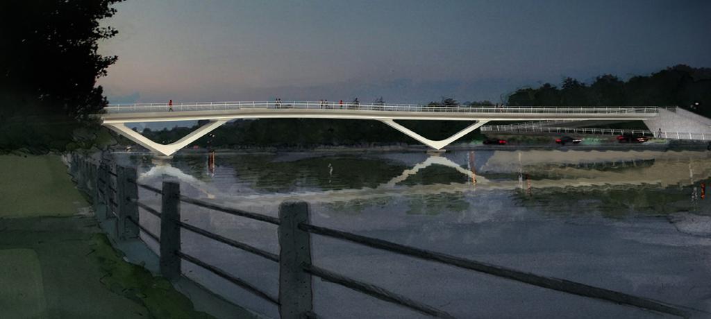
3 engagement strategy that followed included an interactive online blog fostering discussion and seeking real time public input, public open houses, consultation group meetings, and individual meetings with Parks Canada and the National Capital Commission (NCC) - the owners and caretakers of the canal and its heritage landscape. Given its high profile and national significance, the project was also presented on two occasions to the NCC s Advisory Committee on Planning, Design and Realty (ACPDR). This committee, comprising professionals from across the country, provided a national perspective that ensured the resulting plan for the bridge reflected best practices in Canadian planning and design. The project garnered strong community interest and participation. While the recommended plan was ultimately supported by over 30 different community associations, schools, businesses, and interest groups, a number of community issues were identified through the public consultation process that required careful attention. For example, members of the local community were concerned that, by improving access to a nearby major events complex, a new bridge would generate a significant increase in neighbourhood traffic congestion as event patrons flooded the area in search of available on-street parking. To address this issue, the study team completed a comprehensive geo-spatial analysis that visually explained the potential impact at the neighbourhood level, and informed the selection of a preferred location for the bridge crossing. To address concerns that the new bridge would significantly impact existing views of the canal landscape, renderings were prepared that clearly illustrated the bridge s impact and scale from the perspective of adjacent residents and users of the adjacent parkway system, which is designated as a Capital scenic entry route. Design refinements were made to ensure that the bridge location, form, and design emphasized visual lightness, was of an appropriate scale, integrated seamlessly into the world heritage landscape, and minimized impacts to adjacent residents. The recommended plan seeks to create a popular gathering place, with a widened deck that encourages users to pause and enjoy the spectacular setting, and pier footings that are revealed in winter to create a place to rest and relax during the city s skating season and annual Winterlude festival. Sustainable design elements were incorporated throughout, including a structural coating system that provides a durable finish, the use of sustainably harvested ipe wood in the bridge deck and handrails, and energy-efficient LED lighting to enhance public safety and to illuminate the bridge s architecture at night, reducing both energy consumption and light pollution. This $17.5M investment in sustainable transportation will foster healthy communities by encouraging an estimated shift of 2,500 trips every day from personal vehicles to active transportation modes. A winter view from the Rideau Canal skateway depicts the piers of the bridge which double as seating This study stands as an outstanding example of our city staff and its consultants engaging in an open and responsive fashion with all members of the community. The public meetings, the communications with community associations and local residents, and the willingness to listen to and respond to criticism and requests for clarification have been done admirably. As a result, I believe the ultimate recommendations of the report reflect the consensus of the community. A strong majority of immediate residents as well as many from outside the ward who have participated in the process have confirmed that a multi-use crossing of the Rideau Canal in the location identified, and with the design attributes recommended will make a very positive addition to the transportation linkages, and the economic and social life of both the immediate area and the city as a whole, with minimal negative impacts. A new bridge between Fifth Avenue and Clegg Street will play a key role in solving some of the significant congestion and mobility challenges facing the community. Local Ward Councillor David Chernushenko Rideau Canal Multi-Use Crossing 5


4 Explanation The crossing will serve as a new landmark for the capital and will change the way people travel The design of the bridge maintains year-round operations of the Canal as a popular route for boat and skateway travel Innovation & Contribution to the Profession An innovative review of community demographic profiles and existing travel behaviour was completed, which enabled the project team to estimate the projected shift from auto trips to active trips that could be generated by providing this critical network link. This unique approach complements traditional user projections based on trip generation, helps to build a stronger case for investment in sustainable transportation, and can be applied to other active transportation planning projects across the country. This was particularly important for this project given its high-profile location and capital cost of $17.5M. Total Trips for 24 Hour Period: 5,500 57% Non Motorized (Walking and Cycling) 43% Motorized (Car and Transit) GLEBE WEST & WESTERN PORTION OF OLD OTTAWA SOUTH An innovative comparison of travel behaviour between neighbourhoods in the study area Glebe East Old Ottawa East & Eastern Portion of Old Ottawa South Total Trips for 24 Hour Period: 1,600 59% Non Motorized 41% Motorized Any new bridge represents an intervention into the Rideau Canal World Heritage landscape, potentially impacting this beautiful setting. Building support for the bridge therefore required extensive visualization including photo-simulation, artistic rendering and computer modelling. This allowed stakeholders to view bridge design concepts in the site context from a variety of perspectives, and resulted in consensus that the recommended design appropriately complements its setting. In terms of its physical design, the bridge s location and form respond to unique site challenges including year-round canal operations, limited availability of landing space and extremely flat topography. While the curvilinear, v-frame structure is technically complex, the end result is appropriately simple, and visually light, and enhances its surrounding setting. Through iterative stakeholder engagement, the study team has confirmed that this complex structure can be economically constructed and maintained without impacting canal operations CIP AWARDS FOR PLANNING EXCELLENCE SUSTAINABLE MOBILITY, TRANSPORTATION, AND INFRASTRUCTURE
5 Method This project followed a comprehensive five-step planning process with opportunities for meaningful public engagement through a variety of methods. Needs Assessment The case for a new bridge was developed through analysis of problems and opportunities. Our analysis concluded that the canal acts as a barrier to active transportation, there is limited opportunity to improve existing crossings, and a new bridge will change travel behaviour resulting in a shift of 2,500 trips per day from personal auto to active modes. Visioning Our initial consultation event, the visioning and design charrette, resulted in a common vision and series of guiding principles for the project (outlined in the table on page 8). Location Alternatives Once guiding principles were established, we undertook a detailed process to generate and evaluate alternatives to find the optimal crossing and location. Through this process, we identified three potential locations based on site-specific opportunities and constraints. Evaluation criteria to assess these location alternatives were developed and refined through consultation with stakeholders and the public, and a representative family of design alternatives was created for each location to test the range of opportunities and constraints at each site. The subsequent evaluation resulted in the selection of a central location connecting Fifth Avenue to Clegg Street as the preferred spot for a new bridge. This location allows for safe connections to the existing pathway systems without requiring extensive ramping, provides a good connection to the existing street network, and minimizes the active trip lengths. Design Alternatives To determine the recommended bridge design, we consulted with the local community, the general public, Parks Canada, NCC staff, and the NCC s Advisory Committee on Planning, Design and Realty. This consultation resulted in a set of design objectives to guide the design process. Among other design objectives, the recommended plan needed to consider the number of piers in the Rideau Canal, provide navigation clearance for boat traffic, and avoid impacts to resident views. Alternative east and west landing designs, deck alignments, and structural support arrangements were generated and assessed. Through extensive public consultation and evaluation of the advantages and disadvantages of each alternative concept, we arrived at our recommended plan. The Recommended Plan The recommended plan consists of a curvilinear structure that echos the organic geometries of the canal itself. Landings are carefully integrated into the existing landscapes to preserve and enhance the heritage qualities of the canal. The recommended design concept was then subjected to a rigorous structural design process which modelled and tested for pedestrian, thermal, and wind loading impacts, and aeroelastic stability. Finally, to ensure the bridge could be fabricated, transported and erected without significantly impacting canal operations, an implementation and construction staging plan was developed in consultation with City staff, the NCC, and Parks Canada. The recommended plan received overwhelming support at the final public open house in the fall 2012, and was subsequently approved by both Ottawa City Council and the NCC Board of Directors. Rideau Canal Multi-Use Crossing 7


, and thereby promotes sustainable transportation modes as more desirable ways to travel Situate the crossing")
6 Clarity of Goals and Objectives At the outset of the project, it was imperative to develop a collective vision for the project, as well as a set of principles to guide the evaluation of alternatives, which represented the opinions of the stakeholders and approval agencies involved. The guiding principles were grouped into five key themes, known as the five Ls, and were referenced frequently as the planning and design of the project progressed. These guiding principles were used to reinforce the project need, identify and evaluate location alternatives, and test and refine design concepts. As evidenced by the extremely high level of agency and public support, we believe that the resulting recommend plan is an accurate reflection of the initial vision. TOPIC Linkages Location Length & Landing Looks GUIDING PRINCIPLES Plan the crossing in a manner which improves connections between Old Ottawa East and the Glebe, and offers increased access to amenities and key destinations on both sides of the canal Plan the crossing to enhance east-west and north-south connectivity, by linking the crossing to the broader pedestrian and cycling networks Locate the crossing so that it reduces trip lengths (when compared to existing crossings), and thereby promotes sustainable transportation modes as more desirable ways to travel Situate the crossing in a location that minimizes and mitigates impacts to natural systems, including wildlife, vegetation, surface water, and other location-specific environmental features Situate the crossing in a location that maximizes design opportunities to integrate it with, and to make a positive visual contribution to, its surroundings Situate the crossing in a location that maximizes opportunities for place making, and provides a new vantage point for users to appreciate the canal Situate the crossing in a location that minimizes impacts to adjacent communities Implement innovative design to ensure the crossing is compatible with the canal s operation and maintenance, considering the canal s role as a skateway and a navigable waterway Design the crossing to be universally accessible, including to those in strollers and wheelchairs, with special consideration to how pedestrians and cyclists can safely access nearby pathways and cross adjacent driveways Design the crossing to ensure integration of landings with adjacent pathways and road networks, and the safe interaction of pedestrian, cyclist, and vehicular traffic Design the crossing to be respectful of the canal s important built heritage context, and protective of the canal s walls and bed Design landings with the goal of creating an enhanced sense of place, through increasing accessibility and safety, and promoting a variety of uses Design and construct the crossing in a manner that respects and draws on the local, capital and national heritage, while incorporating modern technology Design an iconic structure, which balances the design qualities of a landmark crossing with the responsible use of public funds Design the crossing so that its look and scale complement its setting Design the crossing with consideration to how it looks and functions in different environmental conditions, such as different seasons and times of day Design the crossing so that it does not detract from, but rather enhances, the national historic site and world heritage site designations Design the crossing so that it provides amenities to support opportunities for safe, enjoyable, and memorable experiences for different user groups, and enhances the opportunity for all Canadians to appreciate the unique setting of the Rideau Canal CIP AWARDS FOR PLANNING EXCELLENCE SUSTAINABLE MOBILITY, TRANSPORTATION, AND INFRASTRUCTURE

7 Implementation Thorough consultation and design work was instrumental in delivering a project that was not only supported by the public and agencies, but is also implementable given the unique site constraints. These included working in a UNESCO designated World Heritage setting, minimizing impacts to summer and winter canal operations, identifying construction staging areas in the highly urbanized study area, and confirming a preferred method for transporting prefabricated bridge components to the site. Another important element in the implementation of this project was the development of a comprehensive mitigation plan to avoid or minimize potential environmental impacts during construction and operation. The comprehensive study report which was prepared as part of this project incorporates the combined expertise of environmental planners, ecologists, and engineering professionals, and clearly identifies these commitments. Overall Presentation We recognized the importance of preparing materials that clearly communicated how the design evolved throughout the design process in response to stakeholder input. Throughout the project, our team incorporated comments received from the public into the final design of the bridge, and we traced the design evolution of the project to illustrate how initial design concepts were refined into a single recommended plan. The final recommended plan was also developed with the appropriate level of technical detail, which ensured that the project was implementable and supported by approving agencies. Rideau Canal Multi-Use Crossing The Recommended Plan illustrates a gently curving bridge which gradually expands towards center-span to accommodate a lookout area Presentation materials were available for public review through the project website and in-person at a series of public open houses. At these events, large display boards captioned with bilingual descriptions were organized by key themes and strategically placed throughout the space. Prior to making content available to the public, all materials were reviewed by members of the project s consultation focus groups. This ensured that the messaging was clear and that the accompanying graphics helped the general public to understand sometimes complex design issues and concepts. A variety of visualization techniques were implemented including photo-simulation, artistic rendering and computer modelling to clearly communicate the design concept as it evolved, and identify and address potential negative impacts. The final project deliverable included a comprehensive study report which explains the planning and design process in plain language and is supported by both artistic renderings and technical drawings. The organization of the report was intended to reflect the chronology of the study process and is outlined as follows: Rideau Canal Multi-Use Crossing 9

8 Chapter 1.0 Introduction: Provides an overview of the project, environmental assessment process, and consultation approach. Chapter 2.0 Consultation: Summarizes consultation activities, stakeholder interests, and how they were addressed in the final plan. Chapter 3.0 Identified Problems and Opportunities: Presents the planning and policy context and rationale for the proposed crossing, as well as potential user projections. Chapter 4.0 Existing Conditions and Parameters: Describes the study area and features related to the natural environment, local community, cultural environment, and transportation environment. Technical constraints that influenced planning and design decisions are also discussed. Chapter 5.0 Evaluation of Alternatives: Describes the evaluation of alternative planning solutions, crossing types, crossing locations, and design alternatives. Chapter 6.0 Recommended Plan: Presents a detailed description of the plan and identifies mitigation measures to address potential environmental impacts. Chapter 7.0 Future Commitments: Outlines future consultation and approval requirements, and additional impact assessment studies that should be completed during the detailed design phase of this project. Public Engagement The sensitivity of the site and the scale of the undertaking garnered close attention by key stakeholders, (including the City of Ottawa, Parks Canada, and the National Capital Commission), as well as local community associations and the general public. The study process was carefully orchestrated to ensure optimum participation throughout all phases of the project and to engage directly affected stakeholders. Our consultation approach was designed to meet statutory requirements and capitalize on the local knowledge of the people who live and work in the study area. Our study team understood the importance of communicating through a variety of channels to maximize inclusive and accessible participation. A geo-spatial analysis of the impact a new bridge would have on on-street parking was undertaken to address community concerns Early in the study, a project website and blog were established to encourage discussion on project issues and objectives, share information in real time and provide enhanced public access to the study team. The study team posted discussion questions, moderated discussion, and incorporated public input into the design as it developed. Two consultation focus groups were established for the project: an Agency Consultation Group (ACG) and a Public Consultation Group (PCG). The ACG was composed of representatives from the City of Ottawa, Parks Canada, and the NCC. Its mandate was to provide our team with specialized expertise throughout all stages of the study. The PCG consisted of the community s local groups and associations. Members of the consultation focus groups met in advance of the project s three public open houses to provide design input and to review materials to be presented to the general public. The focus group process ensured that study materials were clear and effective CIP AWARDS FOR PLANNING EXCELLENCE SUSTAINABLE MOBILITY, TRANSPORTATION, AND INFRASTRUCTURE

9 Each public open house was organized as a drop-in style session, with a formal presentation by the study team, followed by a facilitated question and answer session. Bilingual materials were presented at each public open house and content was also made available on the website. These meetings allowed the general public an opportunity to review the plan as it developed, ask questions and provide input. Regular meetings were held with Parks Canada and NCC staff throughout the project to ensure compliance of the recommended plan with design expectations, and policy and regulatory requirements. To obtain a national perspective, the study team presented to the NCC s Advisory Committee on Planning, Design and Realty (ACPDR) on two occasions. Finally, to address specific stakeholder interests and concerns, face-to-face site meetings were scheduled with residents and businesses in the area. The scale and diversity of consultation techniques applied throughout this project resulted in a very high level of participation, with hundreds of comments submitted. A systematic review of all comments took place in order to identify and highlight common themes and to understand the key concerns raised by participants. Sustainability This project supports sustainable mobility by directly contributing to the creation of a world-class pedestrian and cycling realm in Canada s capital. The recommended plan will help the City of Ottawa reduce auto dependence by making active trips safer and more convenient. The benefits of investing in active transportation infrastructure include healthier populations, reduced auto emissions, and more vibrant local economies. By providing this link, it is projected that 2,500 vehicle trips per day will be converted to active trips. In addition to promoting sustainable transportation, the recommended plan includes a number of sustainable design elements. It is proposed that a durable, sustainably-harvested, and climate appropriate species of wood be used in the construction of the bridge s handrail and other areas such as the deck of the lookout area and the bench seating provided along the bridge. Metal components of the bridge will be finished in high-quality paint and layered to provide a strong and durable finish, which will minimize maintenance of the bridge. A view analysis was undertaken to assess the impact of the bridge on views from adjacent residences Energy conservation was also considered in the design of the bridge. For example, LED lighting was selected to provide an understated lighting scheme for the bridge which highlights the structure s architectural detail, and creates a safe crossing environment. The protection of the natural environment was carefully considered in the placement and design of the bridge. For example, the plaza of the east landing of the bridge is centered on a mature oak tree, which was retained through careful planning and design, and creates a focal point in the setting. The ramp and stairs of the east landing are also integrated within the existing landscape to the greatest extent possible, by means of tree retention and landscaping using native species. Finally, the design of the structure and landings endeavours to protect and enhance a heritage site of international importance. The gently curving structure is designed as an elegant line in space with a profile minimized to reduce visual impact on important views. The landings are fully integrated with existing landscapes to protect heritage assets while optimizing circulation and associated recreational opportunities. Rideau Canal Multi-Use Crossing 11
10 Project Documentation

11 Rideau Canal Crossing Environmental Assessment Study Passerelle du Canal Rideau Étude d évaluation environnementale Recommended Plan: Views Connectivity Livability Sustainability Connectivité Habitabilité Viabilité View towards south
12 Rideau Canal Crossing Environmental Assessment Study Passerelle du Canal Rideau Étude d évaluation environnementale Recommended Plan: Views Connectivity Livability Sustainability Connectivité Habitabilité Viabilité View towards north, from Echo Drive
13 Rideau Canal Crossing Environmental Assessment Study Passerelle du Canal Rideau Étude d évaluation environnementale Recommended Plan: Views Connectivity Livability Sustainability Connectivité Habitabilité Viabilité View of west landing and Aberdeen Pavilion, looking south from the Lily Pond
14 Rideau Canal Crossing Environmental Assessment Study Passerelle du Canal Rideau Étude d évaluation environnementale Recommended Plan: Views Connectivity Livability Sustainability Connectivité Habitabilité Viabilité View from west landing, looking northeast
15 Rideau Canal Crossing Environmental Assessment Study Passerelle du Canal Rideau Étude d évaluation environnementale Recommended Plan: Views Connectivity Livability Sustainability Connectivité Habitabilité Viabilité View towards the west, from the bridge
16 Rideau Canal Crossing Environmental Assessment Study Passerelle du Canal Rideau Étude d évaluation environnementale Recommended Plan: Views Connectivity Livability Sustainability Connectivité Habitabilité Viabilité View of east landing, looking east


17 Rideau Canal Crossing Environmental Assessment Study Passerelle du Canal Rideau Étude d évaluation environnementale Recommended Plan: Views Connectivity Livability Sustainability Connectivité Habitabilité Viabilité Night view of the bridge from the north of the Canal Ritz, looking north


18 Rideau Canal Crossing Environmental Assessment Study Passerelle du Canal Rideau Étude d évaluation environnementale Recommended Plan: Views Connectivity Livability Sustainability Connectivité Habitabilité Viabilité Winter view of the bridge from the Canal


19 Rideau Canal Crossing Environmental Assessment Study Passerelle du Canal Rideau Étude d évaluation environnementale Recommended Plan: Views Connectivity Livability Sustainability Connectivité Habitabilité Viabilité Winter view of the bridge from the Canal, looking south
Animating the Rideau Canal December 2013
 Executive Summary Animating the Rideau Canal December 2013 Why study the Rideau Canal? The Rideau Canal has been an important part of Ottawa throughout its history, and has shaped and been shaped by the
Pedestrian Project Award Institute of Transportation Engineers
 Pedestrian Project Award Institute of Transportation Engineers Rideau Canal Pedestrian Crossing Planning and Environmental Assessment Report The Setting The Rideau Canal and its adjacent pathways are highly
10.0 Open Space and Public Realm
 10.0 Open Space and Public Realm 10.0 Open Space and Public Realm The Public Open Space System is comprised of: outdoor spaces available for public use that are either publicly owned (e.g., parks and
Summary of Heritage Input
 Summary of Heritage Input Commonwealth is providing services to the City of Ottawa, as heritage expert in the Lansdowne Revitalization project recognizing not only that Lansdowne accommodates designated
PART 1. Background to the Study. Avenue Study. The Danforth
 The Danforth 1.1/ Study Purpose & Key Municipal Goals 1.2/ The Local Advisory Committee 1.3/ The Project Team 1.4/ Study Process/Summary of Method 1.5/ Summary of Consultation 1.1 Study Purpose and Key
Parks Renaissance. Strategy. Director, Operations. General Committee. Presentation to. May 16, Barb Rabicki
 1 Parks Renaissance Strategy Presentation to General Committee May 16, 2016 Barb Rabicki Director, Operations Incorporates recommendation to complete Parks Renaissance Strategy Feedback / requests from
Town of Oakville Streetscape Strategy
 Town of Oakville Streetscape Strategy Endorsed by PDC on February 10, 2014 (PD-011-14) Town of Oakville Streetscape Strategy [endorsed by PDC February 10, 2014] 0 Town of Oakville Streetscape Strategy
GLEN ROAD PEDESTRIAN BRIDGE ENVIRONMENTAL ASSESSMENT STUDY PUBLIC INFORMATION CENTRE #2 OCTOBER 24, 2017
 GLEN ROAD PEDESTRIAN BRIDGE ENVIRONMENTAL ASSESSMENT STUDY PUBLIC INFORMATION CENTRE #2 OCTOBER 24, 2017 Glen Road Pedestrian Bridge Class Environmental Assessment 1 WELCOME! Welcome to the second Public
SUBJECT: Waterfront Hotel Planning Study Update TO: Planning and Development Committee FROM: Department of City Building. Recommendation: Purpose:
 Page 1 of Report PB-23-18 SUBJECT: Waterfront Hotel Planning Study Update TO: Planning and Development Committee FROM: Department of City Building Report Number: PB-23-18 Wards Affected: 2 File Numbers:
Report to: Development Services Committee Report Date: April 24, 2017
 SUBJECT: Cornell Rouge National Urban Park Gateway - Report on Design Charrette and Next Steps PREPARED BY: Lilli Duoba, MES, MCIP, RPP, Manager, Natural Heritage (ext. 7925) REVIEWED BY: Marg Wouters,
- Document 2 - Algonquin Interpretation and The Continuing Conversation toward a Vision for a Revitalized Lansdowne
 140 - Document 2 - Algonquin Interpretation and The Continuing Conversation toward a Vision for a Revitalized Lansdowne On May 4, 2012, the City of Ottawa participated in a Forum with a number of Elders,
Complete Neighbourhood Guidelines Review Tool
 Complete Neighbourhood Guidelines Review Tool Prepared By: City of Regina Planning Department October 2014 Page 1 of 14 Community Development Review Checklist for Secondary Plans and Concept Plans The
Welcome. Walk Around. Talk to Us. Write Down Your Comments
 Welcome This is an information meeting introducing the applications for proposed redevelopment of the Yorkdale Shopping Centre site at 3401 Dufferin Street and 1 Yorkdale Road over the next 20+ years,
Parks Master Plan Implementation: Phase I Waterfront Use and Design REPORT #: September 7, 2016 File #
 0 'O DI Lan-171-14 1 - THE CORPORATION OF THE TOWN OF COBOURG..,. STAFF REPORT TO: FROM: Mayor and Members of Council Dean A. Hustwick, Director of Recreation and Culture DATE OF MEETING: Committee of
Urban Design Manual PLANNING AROUND RAPID TRANSIT STATIONS (PARTS) Introduction. Station Study Areas
 Introduction. Station Study Areas") 111111 PLANNING AROUND RAPID TRANSIT STATIONS (PARTS) Introduction The ION rapid transit system will link Waterloo, Kitchener and Cambridge through a central transit corridor (CTC). There are a number
111111 PLANNING AROUND RAPID TRANSIT STATIONS (PARTS) Introduction The ION rapid transit system will link Waterloo, Kitchener and Cambridge through a central transit corridor (CTC). There are a number
Town of Cobourg Heritage Master Plan. Statutory Public Meeting
 Town of Cobourg Heritage Master Plan Statutory Public Meeting April 25 th 2016 Presentation Overview 1. Introduction 2. Project background and schedule overview 3. Review of strategic direction content
Welcome to the Oakridge Centre Open House
 Welcome to the Oakridge Centre Open House Why is the City hosting this event? This open house is to inform you of a rezoning application submitted to the City of Vancouver to amend the existing CD-1 (Comprehensive
Ivywild On The Creek PRELIMINARY CREEK DISTRICT MASTER PLAN
 Ivywild On The Creek PRELIMINARY CREEK DISTRICT MASTER PLAN Introduction: Rejuvenating an extraordinary Creekside neighborhood THE CREEKSIDE DISTRICT The Ivywild On The Creek Neighborhood District Master
Workshop 3. City of Burlington Waterfront Hotel Planning Study. September 14, The Planning Partnership
 Workshop 3 City of Burlington Waterfront Hotel Planning Study September 14, 2017 The Planning Partnership The Waterfront Hotel Planning Study 01 The Brant & Lakeshore Planning Study will establish a Strategic
New-Cast Mixed-use Development Proposal King Street West, Newcastle, Ontario
 URBAN DESIGN BRIEF New-Cast Mixed-use Development Proposal King Street West, Newcastle, Ontario TABLE OF CONTENTS: 1.0 Executive Summary 2.0 Creating Vibrant and Sustainable Urban Places: Excerpts from
CITY OF CHARLOTTESVILLE, VIRGINIA CITY COUNCIL AGENDA
 CITY OF CHARLOTTESVILLE, VIRGINIA CITY COUNCIL AGENDA Agenda Date: December 16, 2013 Action Required: Adoption of Resolution Presenter: Staff Contacts: Title: James E. Tolbert, AICP, Director of NDS James
Arlington, Virginia is a worldclass
 EXECUTIVE S U M M A RY Arlington maintains a rich variety of stable neighborhoods, quality schools and enlightened land use policies, and received the Environmental Protection Agency s highest award for
Official Plan Review: Draft Built Form Policies
 PG.30.1 REPORT FOR ACTION Official Plan Review: Draft Built Form Policies Date: May 15, 2018 To: Planning and Growth Management Committee From: Chief Planner and Executive Director, City Planning Division
CANADIAN GUIDE FOR GREENER ROADS AND SUSTAINABILITY CONSIDERATIONS FOR BRIDGES GUIDE 2016 CANADIAN CONSULTING ENGINEERING AWARDS
 CANADIAN GUIDE FOR GREENER ROADS AND SUSTAINABILITY CONSIDERATIONS FOR BRIDGES GUIDE 2016 CANADIAN CONSULTING ENGINEERING AWARDS SUSTAINABILITY CONSIDERATIONS PROJECT TITLE PAGE Member Firm Submitting
SCARBOROUGH SUBWAY EXTENSION. Scarborough Subway Extension. Final Terms of Reference
 Scarborough Subway Extension Final Terms of Reference 1 1.0 Introduction and Background 1.1 Introduction Toronto City Council recently confirmed support for an extension of the Bloor-Danforth Subway from
CAMBIE CORRIDOR PLAN
 1 WELCOME TO THE OPEN HOUSE PUBLIC REALM PLAN - CAMBIE CORRIDOR Thank you for coming to the Cambie Corridor Public Realm Open House! Place a dot where you live Please provide us with your comments and
Living in Albemarle County s Urban Places
 Living in Albemarle County s Urban Places ALBEMARLE COUNTY, VIRGINIA A Closer Look at Albemarle s Approach to Managing Growth and Creating Quality Urban Environments www.albemarle.org Page 2 Living in
Long Branch Neighbourhood Character Guidelines Final Report
 STAFF REPORT ACTION REQUIRED Long Branch Neighbourhood Character Guidelines Final Report Date: October 26, 2017 To: From: Wards: Reference Number: Etobicoke York Community Council Director, Community Planning,
Arkansas River Corridor
 Planning for Access Welcome to the Access Project. This project is a recreational planning effort in response to an interest by regional communities along the Arkansas River corridor. The project plan
JASPER PLACE. Area Redevelopment Plan
 JASPER PLACE Area Redevelopment Plan Executive Summary Jasper Place is an established community where people live, work and play. The Jasper Place Area Redevelopment Plan (ARP) provides a tool to help
CITY COUNCIL AGENDA REPORT
 CITY COUNCIL AGENDA REPORT Subject: COUNCIL MOTION LRT ALIGNMENT REMOVAL FROM THE TRANSPORTATION MASTER PLAN On February 10, 2016 Councillor Hughes provided notice in accordance with Section 23 of Procedure
TransitSupportive. Guidelines GHD. Canadian Institute of Planners 2012 Awards for Planning Excellence Award Category: Planning Publications
 TransitSupportive Guidelines Canadian Institute of Planners 2012 Awards for Planning Excellence Award Category: Planning Publications GHD Project Summary We would like to nominate the Ontario Transit-Supportive
CITY OF HAMILTON PUBLIC WORKS DEPARTMENT Environmental Services Division
 CITY OF HAMILTON PUBLIC WORKS DEPARTMENT Environmental Services Division TO: Chair and Members Public Works Committee COMMITTEE DATE: July 12, 2018 SUBJECT/REPORT NO: WARD(S) AFFECTED: PREPARED BY: SUBMITTED
1 Introduction. Chapter. In this chapter:
 Chapter 1 Introduction In this chapter: 1.1 A Snapshot of the Region 1.2 Towards a Sustainable Region 1.3 The Provincial Context 1.4 Purpose and Organization The Regional Municipality of York Official
SUBJECT: GO Station Mobility Hubs Preferred Concepts: Aldershot GO, Burlington GO and Appleby GO. Planning and Development Committee - Public Meeting
 Page 1 of Report PB-76-17 SUBJECT: GO Station Mobility Hubs Preferred Concepts: Aldershot GO, Burlington GO and Appleby GO TO: FROM: Planning and Development Committee - Public Meeting Planning and Building
SECTION ONE: INTRODUCTION. introduction
 introduction 1 INTRODUCTION Since it was first established in 1843 as a trading post for the Hudson s Bay Company, Victoria has evolved into a Provincial capital city that is recognized across Canada and
DRAFT FOR PUBLIC REVIEW. Game Plan for a Healthy City
 DRAFT FOR PUBLIC REVIEW 2018 Game Plan for a Healthy City 2 Denveright. Parks & Recreation Game Plan Draft for Public Review Draft for Public Review Executive Summary Game Plan Overview Executive Summary
The Master Plan Framework
 The Master Plan Framework The East Harbour Master Plan advances the development of 60 acres of former industrial lands east of the Don River. The Master Plan outlines a vision for a vibrant, transit-oriented
Overview Report. Proposed Development
 Overview Report Proposed Development the construction of a 1km cycle/pedestrian trail including a new footbridge, new car park and entrance road at Drumshanbo Lock and a new pedestrian/cycle road crossing,
Toronto Complete Streets Guidelines
 c. DTAH 58 60 3.1 70 3.2 Performance Measurement 71 3.3 Exceptions Chapter 3 describes the five general steps in the street design process. Not all projects follow these steps, as the number of steps and
Streets for People, Place-Making and Prosperity. #TOcompletestreets
 COMPLETE STREETS FOR TORONTO Streets for People, Place-Making and Prosperity COMPLETE STREETS: A NEW APPROACH A Complete Streets design approach considers the needs of all users people who walk, bicycle,
APPENDIX K WINDSOR OFFICIAL PLAN
 CEAA ENVIRONMENTAL ENVIRONMENTAL IMPACT ASSESSMENT AMBASSADOR BRIDGE ENHANCEMENT PROJECT Replacement Span and Plaza Expansion APPENDIX K WINDSOR OFFICIAL PLAN Avalon Consulting Professionals of Ontario,
Welcome. /The Design Companion 4. /Planning London 7. /Getting Homes Built 8. /Transport & Streets 10. /Tech & The City 12
 Welcome With the draft publication of the London Plan and the Mayor s Transport Strategy (MTS) this year s events programme will examine both documents in detail with a wide range of seminars, debates
2007 TAC SUSTAINABLE URBAN TRANSPORTATION AWARD SUBMISSION. Bridge Over Highway 401 for Pedestrians and Cyclists in Waterloo Region
 2007 TAC SUSTAINABLE URBAN TRANSPORTATION AWARD SUBMISSION Bridge Over Highway 401 for Pedestrians and Cyclists in Waterloo Region Project Partners: City of Cambridge City of Kitchener Region of Waterloo
Vision for Mayfair and Belgravia
 Vision for Mayfair and Belgravia Vision for Mayfair and Belgravia Foreword We have a 20 year vision for Mayfair and Belgravia. It summarises our aspirations for the future of this London estate, which
SUMMARY. An Attractive, Competitive and Sustainable GREATER MONTREAL. Draft Metropolitan Land Use and Development Plan. April 2011
 April 2011 Draft Metropolitan Land Use and Development Plan GREATER MONTREAL An Attractive, Competitive and Sustainable SUMMARY Message from the Chair I am pleased to introduce this draft of the Metropolitan
1.0 Purpose of a Secondary Plan for the Masonville Transit Village
 Report to Planning and Environment Committee To: Chair and Members Planning & Environment Committee From: John M. Fleming Managing Director, Planning and City Planner Subject: Masonville Transit Village
University of Saskatchewan CAMPUS MASTER PLAN. Senate Meeting Preliminary Presentation. April 21, 2018 DIALOG ECS DA WATT
 University of Saskatchewan CAMPUS MASTER PLAN Senate Meeting Preliminary Presentation April 21, 2018 DIALOG ECS DA WATT project process presentation agenda Stakeholder Engagement Project Control phase1
THE CORPORATION OF THE TOWNSHIP OF KING REPORT TO COMMITTEE OF THE WHOLE. The Parks, Recreation & Culture Department respectfully submit the following
 KING THE CORPORATION OF THE TOWNSHIP OF KING REPORT TO COMMITTEE OF THE WHOLE Monday November 2, 2015 Parks, Recreation & Culture Department PRC-2015-44 RE: Public Art Policy 1. RECOMMENDATIONS: The Parks,
North Fair Oaks Community Plan Summary and Information
 North Fair Oaks Community Plan Summary and Information WHAT IS THE NORTH FAIR OAKS COMMUNITY PLAN? The North Fair Oaks Community Plan is part of the San Mateo County General Plan, and establishes policies
response sent to: Dear Sir/Madam Response to: The Review of Designated Landscapes in Wales Stage 2
 Royal Town Planning Institute Cymru (RTPI Cymru) PO Box 2465 Cardiff CF23 0DS Tel +44 (0)29 2047 3923 email walespolicy@rtpi.org.uk Website: www.rtpi.org.uk/rtpi_cymru e-mail response sent to: designatedlandscapesreview@wales.gsi.gov.uk
Scottish Natural Heritage. Better places for people and nature
 Scottish Natural Heritage Better places for people and nature Contents Summary... 3 SNH approach... 5 Place-making in policy and practice... 6 Developing the contribution of the natural heritage to place-making...
Sherwood Forest Park REVITALIZATION PLAN. Public Meeting (P.I.C) # 3 JUNE / 25 /2015
 # 3 JUNE / 25 /2015") Sherwood Forest Park REVITALIZATION PLAN Public Meeting (P.I.C) # 3 JUNE / 25 /2015 1 Agenda i. Where we are in the process and schedule ii. Consultation process iii. Key messages from PIC#2 iv. Purpose
Sherwood Forest Park REVITALIZATION PLAN Public Meeting (P.I.C) # 3 JUNE / 25 /2015 1 Agenda i. Where we are in the process and schedule ii. Consultation process iii. Key messages from PIC#2 iv. Purpose
December 1, 2014 (revised) Preliminary Report -- Thomas Jefferson Site Evaluation
 Preliminary Report -- Thomas Jefferson Site Evaluation") December 1, 2014 (revised) TO: FROM: RE Arlington County Board Thomas Jefferson Site Evaluation Working Group by Carrie Johnson, Chair Preliminary Report -- Thomas Jefferson Site Evaluation The Thomas
December 1, 2014 (revised) TO: FROM: RE Arlington County Board Thomas Jefferson Site Evaluation Working Group by Carrie Johnson, Chair Preliminary Report -- Thomas Jefferson Site Evaluation The Thomas
INTERNATIONAL SOCIETY OF CITY AND REGIONAL PLANNERS 2016 ISOCARP AWARD FOR EXCELLENCE
 INTERNATIONAL SOCIETY OF CITY AND REGIONAL PLANNERS 2016 ISOCARP AWARD FOR EXCELLENCE PROJECT DESCRIPTION WHAT IS ZIBI? Zibi is a world-class sustainable community and redevelopment project by Windmill
Rapid Transit Implementation Working Group September 14, 2017
 Rapid Transit Implementation Working Group September 14, 2017 BACKGROUND Council approved the Rapid Transit Master Plan and Updated Business Case on July 25, 2017. Approval of the RTMP confirmed the BRT
Figure 3-1: Public Realm Plan
 3 Public Realm Figure 3-1: Public Realm Plan 3.1 Public Realm Concept The public realm concept for the Little Mountain site integrates a clear and accessible movement network with public spaces for social
1.0 INTRODUCTION & BACKGROUND
 1.0 INTRODUCTION & BACKGROUND 1.1 GENERAL The Consulting Team was retained by the City of Edmonton in 2010 to complete a for the replacement of the Walterdale Bridge and the approach roads, as required,
Sub-committee on Harbour Plan Review of Harbour-front Enhancement Committee. Ninth Meeting
 Sub-committee on Harbour Plan Review of Harbour-front Enhancement Committee Ninth Meeting Date: 5 October 2005 Time: 3:30pm Venue: Conference Room 15/F, North Point Government Offices, 333 Java Road, North
Streets, Connectivity & Built Environment Working Group August 2, 2017
 Streets, Connectivity & Built Environment Working Group August 2, 2017 DOWNTOWN OAKLAND SPECIFIC PLAN WELCOME Streets, Connectivity & Built Environment Working Group Social Equity Meeting August 2, 2017
An Ambitious Plan: Transforming the blighted South Platte River and surrounding environment into Denver s greatest natural resource.
 CONNECTING THE PEOPLE TO THEIR RIVER SOUTH PLATTE RIVER VISION IMPLEMENTATION PROGRAM: GRANT-FRONTIER PARK TO OVERLAND POND PARK REACH The South Platte River Vision Implementation Program (River Vision)
Local Growth Planning in North Central Green Line Communities
 2018 April 30 Page 1 of 6 EXECUTIVE SUMMARY This report outlines a high-level scope for local growth planning for north central Green Line communities. The catalyst for this review is the significant investments
Agincourt Mall Planning Framework Review Local Advisory Committee Meeting #1 Summary
 Agincourt Mall Planning Framework Review Local Advisory Committee Meeting #1 Summary Wednesday, December 13, 2017 7:00 9:00 p.m. Agincourt Mall, Unit 100 3850 Sheppard Avenue East This is a high level
Longbridge Town Centre Phase 2 Planning Application
 Longbridge Town Centre Phase 2 Planning Application Non-Technical Summary of the Environmental Statement December 2013 Introduction A full application for Planning Permission has been submitted to Birmingham
4- PA - LD - LIVELY DOWNTOWN. LD - Background
 4- PA - LD - LIVELY DOWNTOWN LD - Background The downtown has been the service centre for the community since the city s inception and the area continues to supply people with their personal services,
Bloor St. W. Rezoning - Preliminary Report
 STAFF REPORT ACTION REQUIRED 1638-1644 Bloor St. W. Rezoning - Preliminary Report Date: April 1, 2008 To: From: Wards: Reference Number: Toronto and East York Community Council Acting Director, Community
Welcome. Community Consultation Meeting November 28, Review and discuss the Bathurst Quay Neighbourhood Plan Framework
 Welcome Community Consultation Meeting November 28, 2016 Why Are We Here Today? Review and discuss the Bathurst Quay Neighbourhood Plan Framework Review and discuss an Action Plan for Implementation Next
Scope of Services. River Oaks Boulevard (SH 183) Corridor Master Plan
 Corridor Master Plan") Scope of Services River Oaks Boulevard (SH 183) Corridor Master Plan PROJECT AREA The project area consists of the River Oaks Boulevard (SH 183) corridor bounded by SH 199 at the northern end and the Trinity
Scope of Services River Oaks Boulevard (SH 183) Corridor Master Plan PROJECT AREA The project area consists of the River Oaks Boulevard (SH 183) corridor bounded by SH 199 at the northern end and the Trinity
[PLANNING RATIONALE] For Site Plan Control and Lifting of Holding Zone By-Law 101 Champagne Avenue. May 23, 2014
![[PLANNING RATIONALE] For Site Plan Control and Lifting of Holding Zone By-Law 101 Champagne Avenue. May 23, 2014](/thumbs/75/71599615.jpg "[PLANNING RATIONALE] For Site Plan Control and Lifting of Holding Zone By-Law 101 Champagne Avenue. May 23, 2014") [PLANNING RATIONALE] For Site Plan Control and Lifting of Holding Zone By-Law 101 Champagne Avenue May 23, 2014 Contents 1.0 Introduction... 2 2.0 Site Context... 2 2.1 Adjacent Uses... 2 Figure 1: Site
[PLANNING RATIONALE] For Site Plan Control and Lifting of Holding Zone By-Law 101 Champagne Avenue May 23, 2014 Contents 1.0 Introduction... 2 2.0 Site Context... 2 2.1 Adjacent Uses... 2 Figure 1: Site
1 Welcome! UBC Okanagan Master Plan Update - Open House
 1 Welcome! UBC Okanagan Master Plan Update - Open House UBC is updating the Master Plan for the Okanagan Campus. The purpose of today s Open House is to: Present the draft 2015 Master Plan Answer any questions
PLANNING ADVISORY BOARD AGENDA OCTOBER
 ! City of Langley PLANNING ADVISORY BOARD AGENDA OCTOBER 1, 2014 3-5pm LANGLEY CITY HALL - 112 2 nd Street, Langley WA 1) Call to Order and Roll Call 2) Approval of the Minutes September 10, 2014 3) Public
Don Mills Crossing Study and Celestica Lands Development Application Community Meeting, Open House, and Breakout Discussions
 Consultation Summary Don Mills Crossing Study and Celestica Lands Development Application Community Meeting, Open House, and Breakout Discussions This report is not intended to provide a verbatim transcript
3. Endorse the LRT vision in transforming Surrey into Connected-Complete-Livable communities, and more specifically, the official vision statement:
 CORPORATE REPORT NO: R038 COUNCIL DATE: February 20, 2017 REGULAR COUNCIL TO: Mayor & Council DATE: February 16, 2017 FROM: General Manager, Engineering FILE: 8740-01 SUBJECT: Surrey Light Rail Transit
Chapter 2: OUTLINE PLANNING APPLICATION PROPOSALS. A New Garden Neighbourhood Matford Barton 17
 Chapter 2: OUTLINE PLANNING APPLICATION PROPOSALS A New Garden Neighbourhood Matford Barton 17 2.1. SUMMARY AND STATUS OF THE PROPOSALS 2.1.1. The parameter plans and associated wording in this chapter
THAT the attached Terms of Reference for the Thornhill Centre Street Study be approved.
 COMMITTEE OF THE WHOLE AUGUST 18, 2003 THORNHILL CENTRE STREET STUDY PLANNING FILE: 15.92 Recommendation The Commissioner of Planning recommends: THAT the attached Terms of Reference for the Thornhill
HERITAGE ACTION PLAN. Towards a renewed Heritage Conservation Program. What is the Heritage Action Plan? Key areas of work. A Collaborative Approach
 HERITAGE ACTION PLAN Towards a renewed Heritage Conservation Program What is the Heritage Action Plan? The Heritage Action Plan (HAP) is a set of actions to update the City s Heritage Conservation Program
Plan Overview. Manhattan Area 2035 Reflections and Progress. Chapter 1: Introduction. Background
 Plan Overview The Manhattan Urban Area Comprehensive Plan (the Comprehensive Plan) is a joint planning initiative of the City of Manhattan, Pottawatomie County, and Riley County. The 2014 Comprehensive
1.3 TRANSIT VISION 2040 FROM VISION TO ACTION THEME 1: PUTTING TRANSIT AT THE CENTRE OF COMMUNITIES. Fully integrate transit with community planning
 TRANSIT VISION 2040 FROM VISION TO ACTION TRANSIT VISION 2040 defines a future in which public transit maximizes its contribution to quality of life with benefits that support a vibrant and equitable society,
Edward R. Sajecki Commissioner of Planning and Building
 Corporate Report Clerk s Files Originator s Files CD.03.POR DATE: TO: FROM: SUBJECT: Chair and Members of Planning and Development Committee Meeting Date: February 27, 2012 Edward R. Sajecki Commissioner
13 THORNHILL YONGE STREET STUDY IMPLEMENTATION CITY OF VAUGHAN OPA 669 AND TOWN OF MARKHAM OPA 154
 13 THORNHILL YONGE STREET STUDY IMPLEMENTATION CITY OF VAUGHAN OPA 669 AND TOWN OF MARKHAM OPA 154 The Planning and Economic Development Committee recommends the adoption of the recommendations contained
4 Park Planning and Design
 4 Park Planning and Design Park Constellations Elliot Gateway/Mills Loring North Loop Commons Twins Minneapolis Park & Recreation Board Downtown Service Area Master Plan 4-1 PROJECT APPROACH REFERENCE
PSRC REVIEW REPORT & CERTIFICATION RECOMMENDATION
 PSRC REVIEW REPORT & CERTIFICATION RECOMMENDATION KITSAP COUNTY COUNTYWIDE PLANNING POLICIES July 2, 2012 BACKGROUND A major emphasis of the Washington State Growth Management Act (GMA) is the need to
FOUR MILE RUN VALLEY WORKING GROUP AND CHARGE
 FOUR MILE RUN VALLEY WORKING GROUP AND CHARGE Adopted April 16, 2016 Amended July 19, 2016 Overview of Integrated Effort The overall goal of the Four Mile Run Valley (4MRV) initiative is to develop a comprehensive
Nepean Point CONSULTATION REPORT JUNE 2014
 Nepean Point CONSULTATION REPORT JUNE 2014 Workshop: Nepean Point I Project description Objective: With the renewal of Nepean Point, the National Capital Commission (NCC) presented a project to develop
Evaluation Criteria. Detailed Evaluation Criteria
 Evaluation Criteria Detailed Evaluation Criteria Community Well-being A safe and socially inclusive service that improves access to key community destinations and provides transportation choices for Calgarians.
Active Neighbourhoods Canada SUMMARY REPORT
 Prepared by the Toronto Centre for Active Transportation JUNE 2017 Active Neighbourhoods Canada SUMMARY REPORT OF 4 ONTARIO PROJECTS Sharing participatory methods in Ontario Active Neighbourhoods Canada
1.4 TRANSIT VISION 2040 FROM VISION TO ACTION THEME 1: PUTTING TRANSIT AT THE CENTRE OF COMMUNITIES. Fully integrate transit with community design
 TRANSIT VISION 2040 FROM VISION TO ACTION TRANSIT VISION 2040 defines a future in which public transit maximizes its contribution to quality of life with benefits that support a vibrant and equitable society,
Study Process / Planning Policy Issues
 Memorandum Date: March 13 th, 2009 To: From: Reference: Subject: Murray Thompson, URS Canada Tyler Drygas, Senior Environmental Planner, URS Canada Detroit River International Crossing Study Response to
Design Review Report Llanfoist to Abergavenny Footbridge DCFW Ref: 118 Meeting of 10th August 2016
 Design Review Report Llanfoist to Abergavenny Footbridge DCFW Ref: 118 Meeting of 10 th August 2016 Declarations of Interest Panel members, observers and other relevant parties are required to declare
Public Meeting #3 May 9, 2009 MVVA Team
 Public Meeting #3 May 9, 2009 MVVA Team Welcome to the third Public Meeting for the Lower Don Lands Municipal Class Environmental Assessment (EA) Infrastructure Master Plan and Keating Channel Precinct
Purpose of Open House #3
 Public Meeting #3 May 9, 2009 MVVA Team Purpose of Open House #3 The main purpose of this Open House is to present and seek input on the: Evaluation of transportation and infrastructure design alternatives
Official Plan Review
 Official Plan Review Summary Report - The Built Environment August 2014 Part 1: Introduction Planning for a healthy, prosperous and sustainable community is an important goal for our municipality. From
This Review Is Divided Into Two Phases:
 Semiahmoo Town Centre Review The purpose of this review: To review the Semiahmoo Town Centre Concept Plan, originally approved in 1993, to ensure that this centre will continue to serve the needs of South
Urban Planning and Land Use
 Urban Planning and Land Use 701 North 7 th Street, Room 423 Phone: (913) 573-5750 Kansas City, Kansas 66101 Fax: (913) 573-5796 Email: planninginfo@wycokck.org www.wycokck.org/planning To: From: City Planning
Town Center (part of the Comprehensive Plan)
") Town Center (part of the Comprehensive Plan) Mercer Island Town Center Looking North (2014) In 1994, a year-long process culminated in a set of design guidelines and code requirements for the Town Center
Town Center (part of the Comprehensive Plan) Mercer Island Town Center Looking North (2014) In 1994, a year-long process culminated in a set of design guidelines and code requirements for the Town Center
DRAFT Subject to Modifications
 TREASURE COAST REGIONAL PLANNING COUNCIL M E M O R A N D U M To: Council Members AGENDA ITEM 8 From: Date: Subject: Staff May 19, 2017 Council Meeting Florida Department of Transportation Complete Streets
BRIDGE OF DON MASTERPLAN & PLANNING SUMMARY
 BRIDGE OF DON MASTERPLAN & PLANNING SUMMARY SITE LOCATION The site of the existing AECC lies in an area of predominately residential and business use in Bridge of Don and extends approximately 50 acres.
Executive Summary. Parks and Recreation Plan. Executive Summary
 Parks and Recreation Plan Executive Summary The Whitemarsh Township Parks and Recreation Plan sets forth a vision for how Whitemarsh Township can provide a premiere parks and recreation system reflective
South th E ast Communit ity Centre (SECC)
") South East Community Centre (SECC) 1 New Park Design & Community Centre Update Thursday, February 8, 2018 Public Open House Thank you for attending this Open House! The town and the Consulting Team will
South East Community Centre (SECC) 1 New Park Design & Community Centre Update Thursday, February 8, 2018 Public Open House Thank you for attending this Open House! The town and the Consulting Team will
Courthouse Square Planning & Urban Design Study. Courthouse Square Working Group #13 October 15, 2014
 Courthouse Square Planning & Urban Design Study Courthouse Square Working Group #13 October 15, 2014 1 Courthouse Square Process Working Group Community Courthouse Square Advisory Groups & Civic Associations