SECTION 3.0 PROJECT DESCRIPTION
|
|
|
- Clemence Hicks
- 6 years ago
- Views:
Transcription
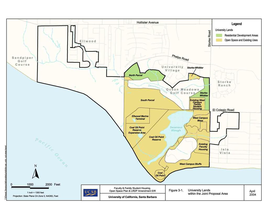
1 3.1 INTRODUCTION SECTION 3.0 PROJECT DESCRIPTION The University of California, Santa Barbara (University) proposes to implement an LRDP Amendment for the University North and West Campuses, develop 236 units of faculty and 151 units of family student housing on the North Campus, and also to implement portions within the University s jurisdiction of the Joint Proposal for the Ellwood-Devereux Coast and the subsequent Ellwood-Devereux Coast Open Space and Habitat Management Plan prepared jointly by University, City of Goleta, and County of Santa Barbara. The proposed LRDP Amendment, faculty and family student housing projects, and Open Space Plan are the results of an unprecedented public-private cooperative effort (reflected in Joint Proposal for the Ellwood-Devereux Coast) to guide development of the last remaining open coastal lands in the western Goleta area. The Ellwood-Devereux Coast area encompasses 10 properties, which are currently owned by multiple public and private entities within the three jurisdictions. It provides the opportunity to comprehensively plan the preservation, management, and development of the Ellwood-Devereux area, rather than considering piecemeal project-byproject approvals. This comprehensive planning approach would allow improved public coastal access, and the preservation and enhancement of 652 consolidated acres of recreational, natural land, and marine environment resources. Potential residential development would be reduced from 760 to 570 units, and future University and private residential development would be clustered adjacent to existing development and infrastructure, and employment centers. The is intended to provide an open space, habitat, and development plan that is, on balance, most protective overall of sensitive natural and coastal resources. The proposed project would be implemented through the amendment of University s 1990 Long Range Development Plan (LRDP) (which guides physical development of the campus) and the approval of the individual housing and open space components encompassed by the. 3.2 PROJECT LOCATION The project area is located in southern Santa Barbara County, California, west of the unincorporated community of Isla Vista, and south and east of the City of Goleta. The project area includes the University North Campus and West Campus, and is generally located west of Storke Road and south of Phelps Road. (Refer to Figure 3-1, University Lands within the Joint Proposal Area.) North Campus The North Campus consists of five general areas: (1) North Parcel (proposed Faculty Housing site) 3-1
2 (2) South Parcel (3) Storke-Whittier Parcel (proposed Sierra Madre Family Student Housing site) (4) Coal Oil Point Reserve Expansion Area (5) Ellwood Marine Terminal The University s North Campus almost completely surrounds the privately-owned Ocean Meadows Golf Course, which is within the jurisdiction of the County of Santa Barbara. The North Parcel (proposed Faculty Housing site) is a 26.5-acre area located south of Phelps Road and north of the Ocean Meadows Golf Course. This vacant parcel is primarily comprised of disturbed annual grasslands, bare dirt in some locations and numerous informal trails that provide access to adjacent open space areas and are used for walking, jogging, off-road bicycling, and similar purposes. The eastern portion of the North Parcel is traversed by Phelps Ditch, a manmade drainage ditch that connects to Devereux Creek. Seasonal wetlands are present at several locations on the Parcel. Portions of the North Parcel are heavily eroded due to removal of topsoil (in the 1960s) to provide fill for the Ocean Meadows Golf Course (which historically was occupied by a portion of the Devereux Slough), and to raise residential development (north of the golf course) above tidal and floodwater inundation. The South Parcel is a 68.7-acre area located south of the Ocean Meadows Golf Course and generally north of the access road to the Ellwood Marine Terminal, with a small area extending west of the Ellwood Marine Terminal to the coast. The South Parcel is heavily eroded due to past removal of topsoil to provide fill for the Ocean Meadows Golf Course and adjacent residential development). Similar to the North Parcel, numerous informal trails traverse the site, which are used for walking, jogging, bicycling, and similar purposes. The Storke-Whittier Parcel (proposed Sierra Madre Family Student Housing site) is an 18.6-acre area consisting of two separate parcels, which are separated by the parking lot for the Ocean Meadows Golf Course. The main Storke-Whittier Parcel (14.8 acres) is located along Storke Road between the existing West Campus Apartments and Whittier Road. The smaller portion of the Parcel (3.8 acres) is located west of the parking lot and south of Whittier Road. The Storke- Whittier Parcel is vacant; however, the driving range for the golf course occupies a portion of the main parcel, which is also traversed by the eastern terminus of a tributary to Devereux Creek. Seasonal wetlands are present at several locations. As no development is proposed for the parcel west of the golf course parking lot, subsequent references to the Storke Whittier Parcel refers to the main parcel located along Storke Road. The Coal Oil Point Reserve (COPR) Expansion Area is a 40-acre area located northwest of the Devereux Slough and southeast of the Ellwood Marine Terminal. Like most of the North Campus, the COPR Expansion Area is vacant, although several informal trails traverse the area. 3-2
3
4 The Ellwood Marine Terminal is a 17.6-acre area located south of the South Parcel and northwest of the COPR Expansion Area. Venoco leases the marine terminal from the University, which includes two petroleum storage tanks. Underground pipelines traverse the area from the offshore oil platform Holly to the Ellwood Marine Terminal area. The Venoco lease will expire in 2016, at which time the oil storage and associated facilities will be removed and native vegetation restored West Campus The West Campus is located west of the unincorporated community of Isla Vista and southeast of the North Campus, and is comprised of seven main areas: (1) Coal Oil Point Reserve (which includes the Devereux Slough) (2) Coal Oil Point (3) West Campus Bluffs (4) West Campus Mesa (5) Devereux Slough North Finger (6) West Campus Apartments Family Student Housing (existing) (7) West Campus Point Faculty Housing (existing) The University s West Campus completely surrounds the privately owned Devereux School property, which within the jurisdiction of the County of Santa Barbara. COPR is a acre 1 ecological reserve (not including the 40-acre Expansion Area described above), part of the University of California Natural Reserve System (UCNRS). The mission of the UCNRS is to contribute to the understanding and wise management of the Earth and its natural systems by supporting university-level teaching, research and public service at protected natural areas throughout California. Of the 34 reserves that comprise the UCNRS, COPR is one of the few reserves located directly on a campus. The Reserve s current uses include preservation of sensitive natural habitats, university-level instruction and research, and public outreach. Limited informal recreation is permitted on the Reserve on an approved interpretive trail (Dune Pond trail), that transverses the Reserve from its northern boundary to the beach, and along Sands Beach outside the fenced plover habitat. The remainder of the Reserve is closed to the 1 In 1979, The Regents designated COPR as a 117-acre natural reserve. Using the currently observed boundaries of COPR, the computerized geographic information system used for analysis in this EIR provided acreage estimates of COPR approximately 8.3 acres greater than the acreage originally designated by The Regents. Throughout the remainder of this EIR, COPR is estimated at acres (not including the 40-acre COPR Expansion Area). 3-5
5 public, but public service activities are encouraged and are authorized through a formal application process. The Reserve is crossed by a number of unauthorized trails to the beach, which will be permanently closed and restored. The Reserve was established as a 49-acre area in 1970 and was subsequently expanded in The Regents designated the 40-acre Expansion Area in 1998 following the purchase of the North Campus by the University. The Coal Oil Point area is an approximately 6.1-acre headland generally bounded on the west by the Coal Oil Point Reserve, the Devereux School to the north, the West Campus Bluffs to the east, and the Pacific Ocean on the south. Existing uses of the Coal Oil Point area include the Cliff House (seminar and conference facility), a 50-space unpaved parking lot, the Reserve manager s residence, the Reserve administrative office, a temporary restroom, a number of old sheds and building pads. Native vegetation and vernal pools in portions of this area have been restored. The West Campus Bluffs is an approximately 37.2-acre area located east of Coal Oil Point, south of the Devereux School and the West Campus Point faculty housing, west of Isla Vista, and north of West Campus Beach. A trail along the bluffs links Isla Vista with the coastal access point at Sands Beach. The area is undeveloped and contains annual grasslands, some vernal pools, stands of mostly non-native trees, and some coastal bluff scrub and trees along the bluff. The West Campus Mesa is a 23.3-acre area east of the Coal Oil Point Reserve, south of the West Campus (Family Student) Apartments, and north the Devereux School and the West Campus Point faculty housing. Existing land uses on the West Campus Mesa include the Orfalea Children s Center and associated parking and the West Campus horse stables, including an historic barn. The West Campus Mesa also includes vacant land that has been identified in the LRDP as a site for future faculty housing. The Devereux Slough North Finger is an approximately 20.5-acre area located between the West Campus Mesa and the Devereux School and the West Campus Point faculty housing. The North Finger historically functioned as part of the slough, but tidal inflow has been restricted, and the area degraded by siltation, invasive exotic species, and historic land use practices. This area is undeveloped and is characterized by 1) riparian wetlands, adjacent uplands, and salt and brackish marshes that are linked to the flooding of the Devereux Slough, 2) groves of trees including major eucalyptus groves and olive trees lining the Devereux Road entrance to the West and Devereux Campuses, and 3) non-native annual grassland and coastal sage scrub. (The majority of the Slough South Finger is on property owned by the Devereux School, although a portion of the South Finger is on University property. The South Finger is highly degraded due to the presence of non-native plants and restricted tidal influx.) The existing West Campus Apartments Family Student Housing is a 250-unit complex located on an 11.9-acre area west of Storke Road and north of Devereux Road. This area includes an approximately 3-acre lawn area along Storke Road. 3-6
6 The existing West Campus Point Faculty Housing is comprised of 65 condominium units on approximately 12 acres south of the North Finger of the Devereux Slough, east of Devereux School and north of the West Campus Bluffs. The University constructed this housing complex for faculty in Individual units are owned by UCSB faculty members and are pricerestricted (to the consumer price index) at resale to another faculty member. 3.3 PROJECT OBJECTIVES The University s objectives for the proposed project include: Provide a variety of additional University-owned faculty housing to meet long-term demand for affordable faculty housing and thereby enable the University to recruit and retain a superior quality of and diverse faculty. Provide additional University-owned family-student housing to meet demand for affordable family student housing, and enable the retention of a broad selection of qualified students. Provide on-campus housing to support closer linkages between residential and academic functions and reduce the number and length of vehicle trips associated with commuting. Create attractive new residential neighborhoods for faculty and their families and student families that are compatible with existing adjacent residential uses. Integrate the proposed family-student housing with the existing West Campus Family Student Apartments Family Student Housing to enhance the existing facilities and create a shared sense of community. Provide a mix of townhome, duplex, studio, and detached single-family homes for faculty, to respond to demand for varied housing types. Maximize the ability of the North Campus to meet identified campus housing needs. Develop much-needed housing in such a manner as to preserve and protect the natural setting of the Coal Oil Point Reserve and other sensitive coastal resources. Implement proposed project components of the Joint Proposal and Open Space Plan within the University s jurisdiction and thereby provide an open space, habitat, and development plan that is, on balance, most protective overall of sensitive natural and coastal resources and assures improved public coastal access and the preservation and enhancement of 652 contiguous acres of open space, natural reserve, and marine environment resources. Implement restoration opportunities and physical improvements identified in the Coal Oil Point Natural Reserve Management Plan. Protect, enhance, and restore key natural, cultural, and scenic resources using an integrated ecosystems approach. Provide for improved public access and compatible passive recreation, consistent with the conservation of significant coastal resources. 3-7
7 Protect Devereux Creek, Devereux Slough and the adjacent upland and marine habitats. Preserve and protect and restore identified sensitive habitat areas, including wetland, native grassland, dune, back dune, and freshwater pond habitat. Provide residential and open space land uses that are consistent, to the extent feasible, with the California Coastal Act policies, and with the prior development plans and expectations for the West Devereux property (now the University s North Campus) that was set forth for this area through standards in the Santa Barbara County Local Coastal Plan. 3.4 PROJECT NEED The will provide 236 units of faculty housing and 151 units of family-student housing to meet existing and future housing needs. As noted in Section (Campus Plans), UCSB has identified a need for student housing since the 1950s and faculty housing since the 1980s. Although the campus has provided various housing options for single students and student families, to date, only 65 units of faculty housing have been developed (the West Campus Point complex completed in 1986) to meet the needs of the more than 1,100 UCSB faculty. Since 1980, the median value of an owner-occupied home on the South Coast of Santa Barbara County increased from $141,200 in 1980, to $320,000 in 1990, and $572,000 in In 2003, the median home sale price on the Santa Barbara South Coast reached $823,708 (UCSB Economic Forecast, 2004). Although home prices are lower in other areas of the County (as discussed in more detail in Section 4.16, Population and Housing), data for the rest of the County reflect this same general trend. In addition to the high cost of housing, availability of owner-occupied housing is extremely low, based on a 0.8 percent vacancy rate in The Santa Barbara South Coast Community Indicators report (prepared annually as a joint project of the UCSB Economic Forecast, the Santa Barbara Regional Economic Community, and the Partnership for Excellence Conference) provides information on social, environmental, and economic factors in the South Coast area of Santa Barbara County. The report includes a housing affordability index as a measure of the percentage of households that can afford to own a median priced home or condominium. The index is based on median family income, median selling prices, mortgage rates, property taxes, and homeowners insurance. The 2003 report estimated that only 5.3 percent of South Coast residents could afford to purchase the median-value single family home, and only 22.3 percent could afford to purchase the median-value condominium. (SCCIP, 2003). The 1990 UCSB LRDP reiterated the need for faculty housing and stated that UCSB: intends to provide as much faculty housing as financially feasible [and that] [a]dditional housing will significantly strengthen the University s ability to recruit superior faculty to the Santa Barbara area, which has been hampered by high market rate housing costs which exceed the ability of many faculty to pay. 3-8
8 UCSB currently employs approximately 1,124 faculty members, of which 81 percent are homeowners. Approximately 15 percent of all faculty members reside outside of the Santa Barbara area and commute to the campus (e.g., from Santa Maria or Oxnard). About one third of existing faculty either resides in rental housing, or commutes to the campus at a considerable distance. According to a survey of faculty conducted in September 2002, 22 percent of faculty are dissatisfied with their housing situation, and housing cost is the aspect with which faculty are least satisfied. The inadequacy of housing opportunities for faculty members makes it difficult to retain and recruit faculty to serve existing University programs. Faculty housing is needed in order to respond to the extremely high costs of housing in the South Coast area. The University is currently recruiting for faculty positions the University has faced difficulty filling these positions, in part due to the inability of faculty to afford housing in the area. The 1990 LRDP EIR estimated the percentage of faculty and staff that would fall within the low to moderate-income group. Using criteria specific to the University, 34 percent of faculty were anticipated to fall within the low to moderate-income group. Using County criteria, of 37 percent of faculty are anticipated to fall within the low to moderate-income group. Both of the criteria indicate that one-third or more of faculty would be within a low to moderate-income group, and, as such would have constraints finding affordable housing in the area. The daunting task of finding suitable and affordable housing has become a major impediment to convincing potential candidates to accept positions at the University. This puts the University at a competitive disadvantage with the other UC campuses and other public and private universities both in California and nationwide, and affects the ability of the University to recruit and retain distinguished faculty. Thus, the would respond directly to the current and projected shortage of affordable faculty housing and help preserve the University s standing as an academic institution in the top tier of American universities. As noted in Section (History of the Ellwood-Devereux Coast), the 1990 LRDP proposed construction of faculty housing adjacent to the West Campus Bluffs. Following input from the community, the University reached an agreement with the County of Santa Barbara, the City of Santa Barbara and a number of concerned community groups to withdraw the proposal for 50 faculty housing units adjacent to the Bluffs, relocate the proposed units to the West Campus Mesa, and pursue alternative sites for the construction of additional faculty housing. In 1994, the University purchased the North Campus from the University Exchange Corporation with the intent of constructing faculty and student residences. In 1998, The Regents amended the LRDP to allow development of 269 units of faculty housing and 144 units of student housing on the North Campus. The 1998 LRDP amendment was not forwarded to the Coastal Commission for review and certification. In addition to the inadequacy of housing opportunities for existing faculty, the UCSB Office of Budget and Planning projects that approximately 533 new faculty will arrive on campus by the academic year , with an average of 60 new faculty members each year in need of suitable and affordable housing. This projection assumes that only a small number of additional faculty 3-9
9 positions will be added each year. There are approximately 100 faculty recruitments currently underway, which were initiated in 2001 through However, most of the new faculty members coming to the University will be replacing faculty members who have resigned or retired, approximately 33 per year. It is assumed that approximately 20 percent of University faculty over the age of 65 will retire each year and that most of the retiring faculty will continue to live in the local area. As of 2003, 69 faculty members were age 65 or older. The characteristics of the local housing market also result in a need for the provision of affordable housing for University students. Housing for students with families would assist in meeting existing demand for University housing and alleviate some of the local constraints on the rental housing market. Presently, there are 343 students on the UCSB Family Student Housing waiting list. Approximately 140 of these students have applied for enrollment, but have not yet been admitted to UCSB. The generation of additional affordable housing for faculty and students with families would therefore contribute to the existing supply of, and alleviate some of the demand for, housing in the area. 3.5 PROJECT DESCRIPTION The proposed project consists of the amendment of the UCSB Long Range Development Plan (LRDP) to permit development of 236 units of faculty and 151 units of family student housing on the North Campus and designate permanent open space consistent with concepts articulated in the Joint Proposal for the Ellwood-Devereux Coast and the subsequent Ellwood-Devereux Coast Open Space and Habitat Management Plan. The individual components of the proposed project would also be the subject of a Notice of Impending Development for consideration by the Coastal Commission. Each of these project components is described in more detail below Amendment of the Long Range Development Plan A LRDP is defined by the Public Resources Code of the State of California (Section ) as a physical development and land use plan to meet the academic and institutional objectives for a particular campus or medical center of public higher education. The LRDP is a policy document that articulates academic goals, identifies the physical development needed to meet those goals, specifies objectives for future development, and provides a land used plan that identifies the potential location of physical development on the campus. The University last completed a major update of the LRDP in 1990, which was followed by approval of the LRDP by the California Coastal Commission in 1993 (in the form of a Local Coastal Program). Following acquisition of the North Campus, in 1998 The Regents of the University approved an amendment to the LRDP that proposed development of faculty and family student housing on the North Campus and reduced the number of housing units proposed for the West Campus. The LRDP amendment proposes to implement the Open Space Plan through the transfer of development rights from the Ellwood Mesa and the South Parcel of UCSB s North Campus, to the areas on the north side of Santa Barbara Shores Park and Ocean Meadows Golf Course. Through this transfer (and concurrent actions by the City of Goleta and the County of Santa 3-10
10 Barbara) a 652-acre area could be permanently preserved as open space and natural reserve by the three participating jurisdictions and private property owners. Without the relocation coordinated by the three participating jurisdictions and the cooperation of private property owners, the benefits of preserving contiguous open areas could not be achieved. A summary of the proposed changes in LRDP land use designations is shown in Table 3-1. A description of each of specific project components follows Specific Components Consistent with the concepts articulated in the Joint Proposal for the Ellwood-Devereux Coast, the University proposes three specific project components: (1) the North Campus Faculty Housing; (2) the Sierra Madre Family Student Housing; and (3) implementation the portion of the Joint Proposal and Open Space Plan within the University s jurisdiction North Campus Faculty Housing The North Campus Faculty Housing Complex would provide 236 units of housing on the North Parcel of the North Campus (north of the Ocean Meadows Golf Course), separated into four neighborhoods (Village Center, West Village, East Village, and Marymount neighborhood) with approximately 90 townhome units, 120 units of duplex housing (in the northern portion of the site), 14 studio units, and 12 detached single-family units. The Village Center neighborhood would consist of 131 units, with 75 townhomes, 44 duplex units, and 12 studio units. The West Village neighborhood would consist of 46 units, with 15 townhomes, 29 duplex units, and 2 studio units. The East Village neighborhood would consist of 28 duplex units and the Marymount neighborhood would consist of 31 units, with 19 duplex units and 12 detached single-family units. Units would be two, three, or four bedrooms and there would be a mix of two- and three-story units in the Village Center neighborhood. Although the homes would vary in size, the total amount of development would be approximately 1,530 gross square feet of living space per unit. The complex would also include a community recreation facility in a common building with a swimming pool. None of the structures would exceed 35 feet in height. The amount of built space would total approximately 430,500 gross square feet, including garages and the community center and pool. Sustainable design practices would be implemented using green resource and energy conservation methods. A proposed site plan is provided in Figure 3-2. Development and grading would occur on approximately 23 of the 26.5 acres on the North Parcel, with an area of native grassland at the southwestern corner of the parcel preserved, along with another area that contains wetlands along the southern perimeter west of Phelps Ditch. 3-11
11 Table 3-1. Summary of Proposed LRDP Amendment Campus Area Current LRDP Designation 1 Proposed LRDP Designation North Campus North Parcel Up to 147 units of faculty housing Up to 236 units of faculty housing South Parcel Up to 122 units of faculty housing 68.7 acres of permanent Open Space, managed as a Nature Park Storke-Whittier Parcel Ellwood Marine Terminal West Campus West Campus Mesa Future Development Area West Campus Mesa Garden Area and Northern Slough Finger Up to 144 units of family student housing 17.6 acres of oil storage facility to be converted to Open Space in 2016 following lease expiration Up to 151 units of family student housing No change from current LRDP designation 100 units of faculty housing 50 units of faculty housing 25.3 acres of recreation and other use 25.3 acres of recreation and Open Space Orafalea Children s Center 10,000 gsf expansion No change from current LRDP designation Coal Oil Point Replace Cliff House No change from current LRDP designation Coal Oil Point Reserve West Campus Bluffs Total Change in Housing Total Change in Open Space and Natural Area acres of existing Reserve, plus 40.0 acre expansion site, designated as Environmentally Sensitive Habitat Areas and Natural Reserve 37.3 acres of Open Space, pending approval of faculty housing elsewhere 513 units of Faculty and Family Student Housing acres of Open Space and Natural Reserve Notes: 1 The 1990 LRDP, as subsequently amended by The Regents Designate acres as Natural Reserve 37.3 acres of permanent Open Space, managed as a Nature Park 437 units of Faculty and Family Student Housing acres of Open Space and Natural Reserve Approximately 68,000 cubic yards of cut and fill would occur on the parcel, with all grading balanced on site. New trails would be provided around the southern boundary of the parcel, linking to the Window Trail along the northwestern boundary of the North Parcel. To minimize runoff from impervious surfaces, pervious areas, vegetated filter strips, and porous pavements would be utilized where appropriate. Surface runoff would be conveyed via surface channels and cobbled swales into bioswales landscaped with native wetland plant species. A series of (new and existing) wetlands at the southeast corner of the site would provide final treatment of runoff from the site prior to discharge into Phelps Ditch (also known locally as El Encanto Creek). The portion of Phelps Ditch that traverses the eastern portion of the site would be modified to 3-12

12
13 stabilize the banks and increase capacity so that 100-year flood flows would be contained within the expanded banks. Parallel berms would be established on both sides of the ditch to provide additional flood protection to the proposed housing and existing adjacent neighborhoods. As required by law, a storm water pollution prevention plan will be implemented on the site, reducing run-off impacts. Vehicular access to the site would be provided via Phelps Road (at the intersection with Cannon Green Drive) and along Marymount Way. A pedestrian and bicycle bridge over Phelps Ditch would provide access between the two portions of the site separated by the ditch. (A vehicular bridge is also be analyzed in this EIR as an option.) Internal roads and alleyways would be narrow in width to serve as traffic calming measures. A total of 557 spaces of parking would be provided (2.36 spaces per unit), with 180 spaces for the townhome housing, 240 spaces for the duplex housing, 28 spaces for the studio housing, 24 spaces for the single-family housing, and 85 on-street spaces. Table 3-2. Summary of and Site Characteristics: North Campus Faculty Housing Proposed Land Use Residential: townhome, duplex, triplex, studio and detached single-family housing Proposed Dwelling Units Townhome: 90 Maximum Building Height Total Development Duplex/Triplex: 120 Studio: 14 Single-family: 12 Total: feet 430,500 gross square feet Proposed Parking Spaces Townhome: 180 Undeveloped Open Space Access Duplex/Triplex: 240 Studio: 28 Single-family: 24 On-Street: 85 1 Total: acres Vehicular: Phelps Road, Marymount Way Pedestrian: Trails from areas to the west and east from Marymount Way 1 Includes 12 spaces for public coastal access 3-15
14 Sierra Madre Family Student Housing The Sierra Madre Family Student Housing Complex would provide 151 units on the 14.8-acre Storke-Whittier main Parcel. No development would occur on the parcel located west of the parking lot for the Ocean Meadows Golf Course. Housing would be located along Storke Road, from north of the El Colegio and Storke Road intersection to Whittier Drive. The housing would be provided in seven clustered complexes along Storke Road (refer to Figure 3-3), and all buildings would set back a minimum of 75 feet from Storke Road and 50 feet from the golf course. The buildings would generally consist of two- and three-story buildings with single level flats with a maximum building height of 35 feet, arranged around courtyard green spaces. Units would be three bedrooms with two baths and average 1,380 gross square feet. amenities would include an approximately 7,375-square-foot community building with meeting, laundry, and recreation facilities, an approximately 725-square-foot storage building, and play structures for toddlers and school-age children. With the support space, the amount of developed space would total approximately 182,000 gross square feet. A site plan for the proposed Sierra Madre Family Student Housing is presented on Figure 3-3. Approximately 10.7 of the 14.8 acres on the main Storke-Whittier Parcel would be graded and occupied by structures, roads and parking lots, with an additional 2.8 acres of existing lawn area (adjacent the West Campus Family Student Housing complex) converted to surface parking. Thus, physical improvements would occupy a total area of approximately 13.5 acres. Grading activities would include approximately 9,400 cubic yard of fill and approximately 5,900 cubic yards of cut, with a net import of approximately 3,500 cubic yards. All building pads would be elevated at least 1 foot above the 100-year flood hazard zone, to reduce potential flood hazards to building occupants. To minimize runoff from impervious surfaces, pervious areas, vegetated filter strips, porous pavements would be utilized where appropriate. Surface runoff would be conveyed via surface channels and cobbled swales into bioswales landscaped with native wetland plant species prior to prior to discharge into the eastern tributary of Devereux Creek. As required by law, a storm water pollution prevention plan will be implemented during constructed on the site, reducing run-off impacts. The twin 24-inch drainage pipes and concrete barrier over Devereux Creek that separates the creek from the Devereux Slough (at the southern edge of the Ocean Meadows Golf Course) would be replaced with a 60 x 42-inchfoot-wide by 5-foot-high box culvert/bridge to reduce upstream flood potential and improve the natural hydrologic functions of the creek-slough system. Development would include a total of 552 parking spaces, 219 of which would replace existing parking for the adjacent West Campus Apartments that would be removed during construction, for a net increase of 333 spaces (2.2 spaces per unit) to serve the new housing. Much of the 3-16

15
16 frontage along Storke Road would be occupied by a landscaped parking lot. A landscape buffer and Class I bike path or multi-use trail would separate this parking area from Storke Road. Bus stop improvements would also be incorporated into project design. A new bus stop would be constructed on the west side of Storke Road, south of Whittier Drive. An existing bus stop located on the west side of Storke Road at El Colegio Road would be relocated further north, adjacent to the proposed parking lot. A cement passenger loading platform would be installed at the relocated bus stop. Both bus stops would include a bench, trash receptacle, passenger information and shelter. The University would coordinate with MTD in the siting and development of the bus stops, and both bus stops would conform to MTD bus stop standards. Access to the northern cluster of residential units would be provided via a driveway off of Whittier Drive and a driveway on Storke Road (with exiting vehicles limited to right-turns). Vehicular Access to the southern residential clusters would be provided via a driveway off Storke Road (limited to right-turns for exiting vehicles), and a new access road (permitting left and right turns onto Storke Road), located generally at the same location at the existing Venoco Access Road (to the Ellwood Marine Terminal), and a driveway to the Francisco Torres Residence Hall (east of Storke Road). This access road would also provide access to the existing West Campus Family Student Housing complex and an adjacent private residential development on the southeastern side of the Ocean Meadows Golf Course (discussed more fully in the separate EIR prepared by the County of Santa Barbara for the Ocean Meadows Residences). Table 3-3. Summary of and Site Characteristics: Sierra Madre Family Student Housing Proposed Land Use Proposed Dwelling Units Maximum Building Height Total Development Residential: single level flats 151 units 35 feet 229,740 gross square feet Proposed Parking Spaces Replacement Parking: 219 Undeveloped Open Space Access Sierra Madre Parking (Net New) Spaces: 333 Total: 552 spaces 3.1 acres Vehicular: Whittier Drive (1 access point) and Storke Road (3 access points) Pedestrian: Whittier Drive, Storke Road 3-19
17 Ellwood-Devereux Coast Open Space Plan and Habitat Management As discussed earlier, one of the primary objectives of the proposed project is to implement that portion of the Open Space Plan under the University s jurisdiction. The Open Space Plan is the result of an unprecedented public-private cooperative effort pursuant to the Joint Proposal for the Ellwood-Devereux Coast to guide development of the last remaining open coastal lands in the western Goleta area. The Plan encompasses 10 properties that are currently owned by multiple public and private entities with the City of Goleta, County of Santa Barbara and University jurisdictions. It provides the opportunity to plan the preservation, management and development of the Ellwood-Devereux area in a comprehensive rather than piecemeal fashion. Comprehensive planning would allow improved public coastal access, and the preservation and enhancement of 652 consolidated acres of recreational, natural reserve, and marine environment resources. Potential residential development would be reduced from 760 to 570 units, and future University and private residential development would be clustered adjacent to existing development and infrastructure, and employment centers. The purpose of the Open Space Plan is to provide an open space, habitat, and development plan that is, on balance, most protective overall of sensitive natural and coastal resources. The Ellwood-Devereux area is part of the lower Devereux Creek watershed, also known as the greater Devereux Slough regional ecosystem. Development is presently allowed in various locations throughout the area. Under existing plans and regulations, development may occur close to sensitive habitat areas and the most valued recreational lands, while less valuable lands are designated as open space. If development proceeds under existing plans, islands of development would fragment open space, disrupt coastal access, recreational use, and the overall ecosystem in the area, even taking careful planning and mitigation into account. The Open Space Plan proposes to protect the resources in the area by relocating development potential away from coastal areas to the northern perimeter of the area where it would be clustered contiguous to existing development, roads and services. Through the transfer of development rights from the Ellwood Mesa and the South Parcel of UCSB s North Campus, to the areas on the north side of Santa Barbara Shores Park and Ocean Meadows Golf Course, a 652-acre area could be permanently preserved as open space and natural reserve. Without the relocation coordinated by the three participating jurisdictions and the cooperation of private property owners, the benefits of preserving contiguous open areas could not be achieved. Open space areas under the University s jurisdiction are summarized in Table 3-4. Implementation of the portion of the Open Space Plan under the University s jurisdiction would also result in coastal access improvements and the improved management and restoration of coastal resources, including environmentally sensitive habitats, scenic resources, historical and cultural resources, public access, and passive recreation opportunities. Coastal access improvements would include: (1) improvement of existing trails, (2) improvement of existing beach access points, (3) installation of a new coastal access stairway, (4) provision of additional public parking, and (5) replacement of an existing portable restroom. 3-20
18 The Coal Oil Point Reserve (including the Expansion Area) would be managed in accordance with the COPR Draft Management Plan. All other open spaces under the University s jurisdiction (identified above and subsequently referred to as Open Space Areas ) would be managed per the Open Space Plan. Refer to Figure 3-4 (Overview of the Open Space Plan Area). 3-20A
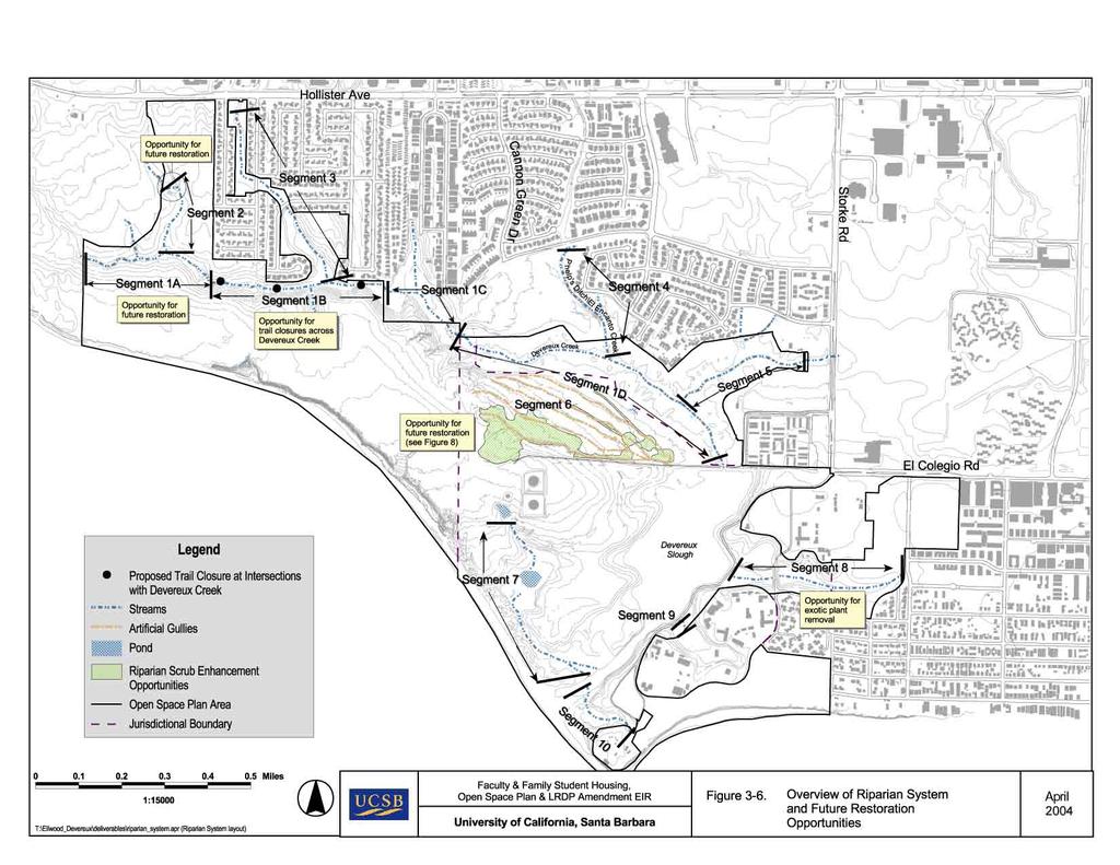
19 Table 3-4. Open Space and Natural Reserve Within University Jurisdiction 1 University Sub-Area 3-21 Acres South Parcel Nature Park 68.7 Ellwood Marine Terminal (future open 17.6 space) 2 Coal Oil Point Reserve (including expansion area) West Campus Mesa and Northern 25.3 Slough Finger Open Space West Campus Bluffs Nature Park 37.3 Total Acres Acreage calculations exclude proposed faculty and student development sites. Acreage calculations also exclude developed land uses. Undeveloped acres include all native and non-native habitats. 2 The Ellwood Marine Terminal will be restored and converted to open space when the existing lease expires in The following types of open space improvements would occur per the Open Space Plan. Trail Improvement. The Open Space Areas are currently crisscrossed with informal networks of trails and footpaths that provide access around and across the sites. In various locations, these informal trails are duplicative (providing access to the same general area) or cross over or near sensitive resources (e.g., native grassland habitat). To minimize impacts to these sensitive resources and reduce habitat fragmentation, various existing trails would be closed, while approximately miles of existing trails on University land would be improved. The extent of trail improvement would depend on the proposed use designation (e.g., pedestrian-only, or a mix of pedestrians, bicycles and limited locations, equestrians), the relative potential for use (e.g., whether the route provide direct access to the coast) and proximity to sensitive resources (e.g., sensitive habitats). Specific trail improvements are described below for each Open Space Area. Trails intended for pedestrian only use would be improved with native materials and limited to 3 to 4 feet in width. Trails intended for mixed pedestrian and bicycle use would have compacted fines (e.g., decomposed granite) with a stabilized surface (e.g., chemical binder), defined shoulders and a width of 10 to 12 feet. Trails for equestrian use would include either a designated 3-foot-wide equestrian-only tread (e.g., parallel to the Venoco paved access road) or would be equivalent to the mixed pedestrian and bicycle trails (with a surface of compacted fines with a binder, a defined shoulder, and total width of 10 to 12 feet). Trail construction and maintenance would emphasize the use of natural or natural-appearing materials consistent with the rural/natural character of the area. Whenever feasible, indigenous materials would be incorporated into improvements, and the limits of disturbance should equal the limits of required grading. Refer to Figure 3-5 (Proposed Trail System)
20 Beach Access Improvements. The informal trail network across the Open Space Areas provides access to the coast at several locations. To minimize impacts to sensitive resources, access to the coast would be improved at three locations by the provision of a boardwalk and/or coastal access stairway, which would formalize access points, improve public safety and improve protection of sensitive resources. The specific location of these improvements is identified below. New Beach Access. A bluff top trail currently exists along the West Campus Bluffs, providing access between Isla Vista and the beach at Coal Oil Point. At some locations along the bluff, recreation users have created informal paths to gain access to the beach, creating a public safety hazard and accelerating erosion of the coastal bluffs. A new beach access stairway is proposed to improve beach access, improve public safety, reduce damage to coastal bluff scrub habitat, and reduce coastal bluff erosion. New Public Parking. Up to 74 additional coastal access parking spaces would be provided: 1) at the western terminus of Phelps Road; 2) on the West Campus Mesa south of Cameron Hall; 3) on the West Campus Bluffs west of Camino Majorca; 4) on the West Campus Bluffs near Coal Oil Point. Restroom Improvement. The existing portable restroom at Coal Oil Point would be replaced with a self-contained permanent facility (e.g., a pit toilet without running water, which would periodically be serviced) in the same general location. The Open Space Areas would be subject to management actions intended to preserve and restore land resources, marine resources and compatible coastal recreation opportunities. Management actions identified in the Open Space Plan that are relevant to Land Resources include: Habitat Restoration. Site restoration, including restoration of wetlands, is proposed for select areas degraded by erosion and poorly controlled public use. Public access and visitor use within sensitive habitats would be directed onto a system of well-defined trails and beach access points. Interpretive signs would be installed to educate the public about the sensitivity of these habitats, the need to protect the Western snowy plover and other sensitive wildlife species that these habitats support, and the need to remain on designated trails. As noted above, the COPR Draft Management Plan would guide restoration within the Coal Oil Point Reserve. Passive restoration methods, such as eliminating recreation activities through trail closures where they currently intersect sensitive habitats, are proposed in certain locations. Closed trails would be restored to blend with adjacent native vegetation. Degraded areas would be restored using existing or adjacent native species with the minimal level of effort needed to restore the habitat to a natural state. 3-22

21

22
23 Active restoration methods, such as planting to convert non-native annual grasslands to native grasslands and coastal scrub, are proposed where passive methods are not likely to be successful. In addition, short-term irrigation of revegetated areas may occur at some locations. Opportunities for habitat restoration are identified on Figure 3-6 (Overview of Riparian System and Future Restoration Opportunities), Figure 3-7 (Vernal Pool Restoration Opportunities) and Figure 3-8 (Upland Habitat Restoration Opportunities). Trail Closures. Trail closures would be designed to divert users away from sensitive locations without the use of expensive fencing and barriers to the degree possible. This would include some or all of the following measures: Install notice of trail closures at public access points Install notice of trail closures at public access points Provide physical barrier/obstacle (fence, logs, rocks embedded into ground) in combination with signage indicating trail closure and reason why (resource protection, restoration) Install logs with dense plantings of locally native species to direct users to designated trails Install low fences or cordon (3 to 4 feet high) to discourage trail users from venturing off designated trails, particularly in areas with sensitive resources Trail Markers, Barriers, and Fences. Trail markers and barriers may be used to keep users on trails and avoid adjacent ESHAs and off-trail portions of the COPR. Trail markers would be less than 36 inches in height and would consist of single post parkers made of recycled material, wood, or faux wood concrete. Trail barriers to prevent access to sensitive habitat would include large stones, plantings, logs, and low-profile post-and-cable fencing. Post-andrail or post-and-cable fencing may be used around the perimeter of new parking facilities. Limitation of Uses. Certain uses would be prohibited within the Open Space Areas including vehicular use. Certain trails would be designated as pedestrian-only, and bicyclists and equestrians limited to specific trails. Dogs are not allowed in COPR. There is a current exception on Sands Beach where dogs are permitted outside the fenced plover area if they are on leash and do not disturb the plovers. This is consistent with the snowy plover management guidelines outlined in the COPR Management Plan. Erosion and Sedimentation Controls. Land disturbance related to coastal access improvements and restoration or management of habitats and coastal resources could result in erosion of exposed soil surfaces and sedimentation of downstream areas, including the Devereux Slough. Management actions to reduce potential erosion would protect water quality in Devereux Creek and its tributaries, the Devereux Slough and the adjacent marine 3-27
24 environment, consistent with the Clean Water Act and the University s Storm Water Management Plan. Urban Runoff Control Measures. Stormwater runoff from parking lots and structures within the Open Space area and from adjacent developed areas could contain contaminants typical of urban land uses. Management actions, such as Best Management Practices, would protect water quality in Devereux Creek and its tributaries, the Devereux Slough and the adjacent marine environment, consistent with the University s Storm Water Management Plan. Site Remediation. Previous use of the Open Space Area has included petroleum recovery activities, which may have resulted in surface, or subsurface contamination from hydrocarbons and related substances. Management actions are identified to remediate such contamination as appropriate. Scenic Resources. Improvement or closure of existing trails would be undertaken with native materials whenever possible, with logs, boulders, or low-fencing to preserve the undeveloped character of the Open Space area. Benches, fences or other structures would be similarly designed to be unobtrusive and blend into the surroundings. Cultural and Historic Resources. Proposed coastal access improvements and the management and restoration of habitats and other sensitive coastal resources are intended to avoid known cultural resources. Management actions are identified to reduce damage to unknown cultural resources, to the extent such resources are encountered during physical improvements, or restoration and management activities. Management actions identified to reduce erosion and sedimentation, protect water quality, and remediate site contamination would also serve to protect adjacent marine resources from degradation associated with sedimentation or the introduction of urban stormwater contaminants or hydrocarbon substances from contaminated areas. The Open Space area currently provides a range of recreational opportunities, including walking, jogging, bird and wildlife viewing, dog-walking, bicycle riding, and equestrian uses. These activities would be preserved, although some of these would be restricted in certain locations where necessary to protect sensitive resources from further degradation. In addition to the more active management techniques described above, long-term monitoring and evaluation of coastal resources would be performed. Recreational use would be monitored and evaluated using a qualitative approach similar to that used by the National Park Service, referred to as the Visitor Experience and Resource Protection (VERP) process. The VERP process is an iterative process of monitoring, evaluation, and adjustment. If the results of monitoring and data collection from this process demonstrate a possible degradation of on-site 3-28
25
26

27
28 resources over time, then management actions would be recommended to mitigate such impacts. Adjustments to the plan could include changes to proposed trail alignments and/or coastal access points, seasonal trail closures, physical improvements to trail and access facilities, and/or other reasonable use limitations. Thus the Open Space Plan may be subject to periodic revisions as needed. In addition to the more active management techniques described above, long-term monitoring and evaluation of coastal resources would be performed. Recreational use would be monitored and evaluated using a qualitative approach similar to that used by the National Park Service, referred to as the Visitor Experience and Resource Protection (VERP) process. The VERP process is an iterative process of monitoring, evaluation, and adjustment. If the results of monitoring and data collection from this process demonstrate a possible degradation of on-site resources over time, then management actions would be recommended to mitigate such impacts. Adjustments to the plan could include changes to proposed trail alignments and/or coastal access points, seasonal trail closures, physical improvements to trail and access facilities, and/or other reasonable use limitations. Thus the Open Space Plan may be subject to periodic revisions as needed. The specific open space management actions and activities proposed for each sub-area are described below North Campus North Parcel. As described above, most of the North Parcel is proposed for faculty housing and thus is not covered by the Open Space Plan. The following open space amenities would be incorporated into the housing development: A pedestrian and bicycle trail along the southern perimeter of the housing site (Trail 10) A pedestrian and bicycle trail along the western edge of Phelps Ditch (Trail 11) A 12-space public parking facility and trailhead near the western terminus of Phelps Road (Trail 12 at Phelps Road) Trail 12 provides one of several key public access links between residential areas near Phelps Road and the Open Space Areas. This trail extends west from the proposed public parking area, then south along the eucalyptus windrow on University property, and west where it crosses into the City of Goleta s Ellwood Mesa area (at the Doty Parcel ) and connects with Trail 10. This trail would be constructed with an all-weather binding agent designed to minimize trail erosion during the wet season. The saltwater marsh habitat, located at the western edge of the Ocean Meadows Golf Course would be maintained, and no development would occur within the 100-foot buffer area around this wetland. In addition, a small area of native annual grassland in the southwestern portion of the Parcel would be preserved and restored. Two wetlands located along the southern perimeter of the Parcel (west of Phelps Ditch) would be incorporated into a larger area of wetlands, into which the on-site bioswales would drain (and then drainage would continue into Phelps Ditch). 3-35
29 North Campus South Parcel. The North Campus South Parcel would be substantially restored from its current degraded condition, preserved as permanent open space, and operated as a nature park. An overview of the proposed South Parcel Nature Park is provided in Figure 3-9 (South Parcel Nature Park Restoration Concepts). Based on the existing and historic distribution of endemic vegetation communities, the Open Space Plan proposes to protect and restore areas of riparian scrub, coastal scrub, native grasslands, vernal pools, and perennial grassland and remove invasive species, such as pampas grass. Vegetation of drainage swales and other measures would be employed to reduce erosion. The project would include repair of eroded gullies using check dams and stabilizing banks and planting of native riparian species within an identified mitigation site for North Parcel development impacts. Invasive exotics would be removed from the drainages at the South parcel prior to grading and planting. Approximately 1,500 linear feet of riparian habitat (approximately 8 to 15 acres depending on funding) would be enhanced and restored on the South Parcel. Enhancement and restoration opportunities could also include revegetation of bare, eroded areas with a dense cover of native plants to greatly reduce runoff volume and erosion by promoting increased soil absorption. Barriers and/or fences would be installed, as needed, at the edge of perimeter trails and adjacent to restoration areas to keep users on the trails. Trail closures would also restore buffer areas around two existing vernal pools and create opportunities for creation of new vernal pools or wetlands. Restoration activities in the newly created South Parcel Nature Park would be managed by the University Department of Ecology, Evolution, and Marine Biology. An informal amphitheater for educational and interpretive uses by small groups is proposed at the east end of the site. An interpretive sign program is proposed throughout the South Parcel Nature Park to identify native species and inform the public about key characteristics of the setting. Benches would be located along the internal trails for people to bird watch and enjoy the views. Together, these interpretive elements would serve as a focal point of public education and complement the resource management efforts in the adjacent COPR to the south and the Ellwood Mesa to the west. Access to the South Parcel would be provided by a series of trails that connect to public parking areas, adjacent residential neighborhoods, and surrounding open space areas. The Anza Trail (Trail #6) would link the Nature Park to the proposed public parking area at Cameron Hall on the West Campus Mesa, and Trail 26 would provide connections from the existing West Campus Apartments and the proposed Sierra Madre student family housing. Trail 14 (via connections to Trails 10, 11, and 12) would connect the proposed faculty housing and existing neighborhoods to the north to the Nature Park. Trails 6, 17, and 22 would provide connections from the Ellwood Mesa and adjoining neighborhoods, and Trails 5, 7, and 22 would provide access from the Open Space areas to the south, including the beach (at Access Point D). No vehicular access would be allowed to the general public, although limited maintenance and 3-36

30
31 emergency vehicles would be permitted to use the Ellwood Marine Terminal access road. While the trails around the perimeter of the Nature Park would accommodate various trail users, trails on the interior of the Park would be restricted to pedestrian use. An equestrian tread would be constructed along the north shoulder of the existing paved Venoco Access Road (to the Ellwood Marine Terminal). West of the marine terminal, the trail would leave the road and connect to the City-owned Ellwood Mesa area. The roadway and the extension of Trail 6 to City of Goleta property would be a segment of the proposed Anza Trail North Campus Storke-Whittier Parcel. As described above, the Storke- Whittier site is to be developed for family student housing and thus is not covered by the Open Space Plan. Open space amenities would be incorporated into the housing development, including: A Class-II bicycle land along the southern perimeter of the proposed Sierra Madre Family Student Housing (unnamed trail) would provide a connection to Storke Road. A pedestrian and bicycle trail along the northwestern perimeter of the proposed Storke Road housing site (Trail 26), connecting Storke Road to the Ellwood Marine Terminal access road. This trail would originate at Storke Road, pass through University property, then onto the County s Ocean Meadows Residences site, and then connect with the unnamed trail described above. The northwestern portion of the Storke-Whittier site, located west of the Ocean Meadows Golf Course entrance, would be designated as permanent open space. The freshwater marsh habitat, located at the eastern terminus to the unnamed tributary to Devereux Creek (near Storke Road) would be maintained, and no development would occur within the 100-foot buffer area around this wetland. The small area of vernal pool habitat located along the southern edge of the main Storke-Whittier Parcel, near the existing Venoco Access Road would be removed and restored following grading of the site. No development would occur within the 100-foot buffer area around the restored vernal pool. Trails within the site would provide connections to the Open Space Areas for both the general public and the residents. Trails would incorporate the same rustic design features as in the undeveloped Open Space Areas. These features would be managed and maintained by the University Department of Housing & Residential Services West Campus West Campus Mesa. The northern slough finger on the West Campus Mesa would be designated as open space and environmentally sensitive habitat. Divide Road would be abandoned as a road, but maintained as a trail. A pedestrian and bicycle trail (Trail 4) would be developed linking the University s Storke Wetlands, through Del Sol Vernal Pool Reserve, and Camino Corto Open Space, westward through the slough finger, along the eastern boundary of Coal Oil Point Reserve, and beyond. Select non-native trees would be 3-39
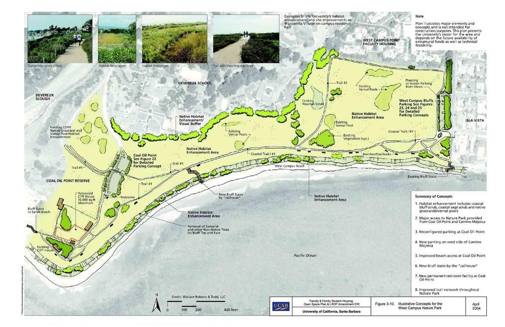
32 removed and wetlands, wetland buffers, sage scrub, and the oak woodland would be restored. The horse stables would remain in place. A 20-space public parking area (including one handicap space) would be developed at the rear of Cameron Hall, located south of Devereux Road near the Storke/El Colegio Road entrance to the West Campus. This parking area would provide trailhead access to the eastern portion of the Anza Trail (Trail 6) within the Open Space Plan area. The Anza Trail (Trail 6) would extend along the north side of Devereux Road from the Storke/El Colegio intersection to the eastern boundary of COPR where it would veer north and then switchback across the slope to facilitate safe access between Devereux Road and the edge of the Slough. The trail along the northeastern perimeter of the Devereux Slough would be raised and realigned northward to set it back from the salt marsh and above low flood stages. It would connect into the Ellwood Marine Terminal access road at its easternmost corner. Access from the Cameron Hall trailhead and the Anza Trail would occur at the existing pedestrian crossing where West Campus Point Road intersects Devereux Road. The existing horse stables in the eastern part of the Mesa would remain. Horse trailer parking would continue be provided for Horse Boarders Association members at the University stables. Equestrians would access the Anza Trail via a new trail adjacent to the access road to the University Children s Center. Devereux Road would continue to be available for on-street (e.g., no bike lane) bicycle access and existing vehicular turnouts and viewing benches would be maintained West Campus West Campus Bluffs. The West Campus Bluffs area would be permanent open space comprised of enhanced native plant communities. The area would include improved pedestrian and bicycle trails (Trail 1 along the bluff edge and Trail 2 connecting the faculty housing to the bluffs), viewing and resting areas along the bluff, a new stair access from the bluffs to the beach, and habitat restoration. An overview of the proposed West Campus Bluffs Nature Park is provided in Figure 3-10 OSP Figure 11). Restoration activities in the newly created West Campus Bluffs Nature Park would be managed by the University Department of Ecology, Evolution and Marine Biology, and would focus on vernal pools, native grassland, coastal scrub, coastal bluff enhancement, and exotic plant control. Simple, low profile barriers would be constructed at selected locations along the top of the bluff to protect the public and to prevent access down the bluff face, which contributes to erosion and loss of vegetation. Trail closures would create opportunities for creation of new vernal pools that would mimic historic vernal pool distribution on the bluffs. Trail closures would also reduce impacts to bluff scrub and dune habitat associated with informal access. Trail 1 would be sufficiently improved to allow handicap access along the bluff top between Coal Oil Point and Camino Majorca, consistent with ADA standards for ground surface stability, slope limitations, and other design considerations. 3-40
33
Regional Overview, Existing Jurisdictions, and Governing Land Use Plans
 4.6 LAND USE 4.6.1 Introduction This section of the EIR describes existing land uses on the North and West Campuses and analyzes the potential for implementation of the proposed project to conflict with
4.10 RECREATION Introduction
 OPEN SPACE PLAN, & LRDP AMENDMENT EIR 4.10 RECREATION 4.10.1 Introduction This section describes existing recreational resources on the University s North and West Campuses, and analyzes whether the project
4.9 VISUAL RESOURCES Introduction
 4.9 VISUAL RESOURCES 4.9.1 Introduction This section describes the visual setting of the North and West Campuses, and evaluates the potential for changes of residential development and undeveloped area
Coal Oil Point Reserve Management Plan LRDP Policy Consistency Analysis August Consistent. All applicable LRDP policies apply to the COPRMP.
 APPENDIX G LRDP CONSISTENCY TABLE Coal Oil Point Reserve Management Plan LRDP Policy Analysis August 2015 INTRODUCTORY POLICIES Policy INTRO-1 - The policies of the Coastal Act (PRC Sections 30210 through
PRE-DESIGN CONCEPT REPORT GRAND CANAL RESTORATION
 PRE-DESIGN CONCEPT REPORT GRAND CANAL RESTORATION Project Background November 19, 2007 Executive Summary The Grand Canal is an important tidal waterway in the Venice community of Los Angeles, California,
U C S B OFFICE OF CAMPUS PLANNING & DESIGN. Notice of Impending Development. September Trailer 309, 320, and 327 Demolition Project
 U C S B OFFICE OF CAMPUS PLANNING & DESIGN E H T LET A U N IV E R SIT T H Y E R E 186 O F University of California Santa Barbara September 2013 Notice of Impending Development Trailer 309, 320, and 327
5.0 MITIGATION MEASURES ADOPTED PURSUANT TO THE 2004 FEIR FOR THE 2004 LRDP...5-1
 Faculty and Family Student Housing, Open Space Plan, and LRDP Amendment EIR Addendum TABLE OF CONTENTS 1.0 INTRODUCTION...1-1 1.1 PROJECT INFORMATION...1-2 1.2 SUMMARY OF NEW INFORMATION AND REVISIONS
The following principles guide the development of goals and strategies to protect and promote these amenities:
 OPEN SPACE/PARKS/TRAILS/RECREATION GOALS/STRATEGIES Cherry Hills Village is a living environment that offers low density development, open areas, public scenic vistas, public trails and public parks. This
I. INTRODUCTION... 1 II. PROJECT DESCRIPTION... 1 III. PROCEDURE... 2 IV. CONSISTENCY WITH THE 1990 LONG RANGE DEVELOPMENT PLAN...
 NOTICE OF IMPENDING DEVELOPMENT UNIVERSITY OF CALIFORNIA, SANTA BARBARA East Gate Vegetation Removal Project Table of Contents I. INTRODUCTION... 1 II. PROJECT DESCRIPTION... 1 III. PROCEDURE... 2 IV.
Venice Pumping Plant Dual Force Main Project Draft EIR
 City of Los Angeles 5.9 LAND USE PLANS 5.9.1 Environmental Setting Venice Pumping Plant Dual Force Main Project Draft EIR The Project lies within the bounds of Los Angeles County and the City of Los Angeles.
3.10 LAND USE SETTING PROJECT SITE EXISTING LAND USE DESIGNATIONS AND ZONING. General Plan Land Use Designations.
 This section of the Draft EIR addresses the existing land uses on and adjacent to the project site and discusses the potential impacts of the proposed project on existing land uses. Key issues addressed
3. VISION AND GOALS. Vision Statement. Goals, Objectives and Policies
 Vision Statement Queen Creek s interconnected network of parks, trails, open spaces and recreation opportunities provide safe and diverse activities and programs that sustain its unique, small town, equestrian
PROJECT SUMMARY. University of California, Irvine Humanities Building. Project No FINAL INITIAL STUDY/MITIGATED NEGATIVE DECLARATION
 PROJECT SUMMARY University of California, Irvine Humanities Building Project No. 991077 FINAL INITIAL STUDY/MITIGATED NEGATIVE DECLARATION State Clearinghouse No. 2007011035 March 2007 Humanities Building
STREAM BUFFERS
 88-415 STREAM BUFFERS 88-415-01 PURPOSE In the Kansas City region and throughout the nation, vegetated stream buffers have been clearly shown to protect stream stability and related infrastructure, improve
Gold Line Bus Rapid Transit Transit Oriented Development (BRTOD) Helmo Station Area Plan
 Helmo Station Area Plan") Appendix F Gold Line Bus Rapid Transit Transit Oriented Development (BRTOD) Helmo Station Area Plan Introduction and Purpose of the Plan The Gold Line Bus Rapid Transit facility is an eleven-mile dedicated
Appendix F Gold Line Bus Rapid Transit Transit Oriented Development (BRTOD) Helmo Station Area Plan Introduction and Purpose of the Plan The Gold Line Bus Rapid Transit facility is an eleven-mile dedicated
5.1 AESTHETICS AND VISUAL RESOURCES Physical Setting
 5.1 AESTHETICS AND VISUAL RESOURCES 5.1.1 Physical Setting Aesthetic values are an important aspect in establishing the identity, sense of place, and quality of life in a community. Natural features in
Master Plan Objectives and Policies
 Master Plan Objectives and Policies Introduction This chapter identifies the Park issues and recommended policies established by this Master Plan. The issues were identified through meetings with staff,
ADOPTED CAPITAL IMPROVEMENT PROGRAM BUDGET ARROYO PROJECTS
 ADOPTED CAPITAL IMPROVEMENT PROGRAM BUDGET ARROYO PROJECTS HAHAMONGNA FY 212-216 Capital Improvement Program Priority Description Total Estimated Costs Appropriated Through FY 211 Adopted FY 212 FY 213
Ten Mile Creek Planning Area
 PLANNING AREA POLICIES TEN MILE CREEK Ten Mile Creek Planning Area Location and Context The Ten Mile Creek Planning Area ( Ten Mile Creek area ) is located south of the current Boise AOCI, generally south
Exhibit A. 8:9 Scuffletown Rural Conservation District
 Exhibit A 8:9 Scuffletown Rural Conservation District 8:9.1 Intent and Purpose The Scuffletown Rural Conservation (SRC) District is intended to provide for residential development that supports the development
Goal 1: To Encourage the Orderly, Harmonious and Judicious Use of University Resources in the Development of University Land.
 2.0 Future Land Use Goal 1: To Encourage the Orderly, Harmonious and Judicious Use of University Resources in the Development of University Land. Objective 1.1: Make available future building sites that
When planning stormwater management facilities, the following principles shall be applied where possible.
 2.0 Principles When planning stormwater management facilities, the following principles shall be applied where possible. 2.0.1 Drainage is a regional phenomenon that does not respect the boundaries between
U C S B OFFICE OF CAMPUS PLANNING & DESIGN. Notice of Impending Development. January Segovia Road Access Project
 U C S B OFFICE OF CAMPUS PLANNING & DESIGN E H A UNIVERSIT T Y LET T H E RE 186 OF BE 8 LIGH T CALIFORNIA University of California Santa Barbara January 2013 Notice of Impending Development Segovia Road
EXHIBIT B PROJECT NARRATIVE POULSBO MEADOWS
 EXHIBIT B PROJECT NARRATIVE POULSBO MEADOWS Name of Project: Poulsbo Meadows; A Planned Residential Development (PRD)/Plat Applicants Name: PBH Group LLC/Byron Harris PO Box 1010 Silverdale, WA 98038 Description
Arana Gulch Park Master Plan
 809 Center Street, Santa Cruz, CA 95060 Arana Gulch Park Master Plan Executive Summary The Arana Gulch Master Plan completes the last master planning work for the parks and open spaces within the City
UNIVERSITY OF MICHIGAN:
 Chapter Eight UNIVERSITY OF MICHIGAN: North Campus I. Introduction The University of Michigan currently owns approximately 800 acres of land in the northeast section of Ann Arbor. North Campus refers to
The Vision. Photo provided by The Minervini Group. 46 Vision, Objectives & Strategies
 Vision, Objectives & Strategies The is the public framework and guide for future development of the Grand Traverse Commons. The establishes public polices for infrastructure, the preservation of natural
Creekstön W.E.T, Inc Davis Canon Road San Luis Obispo, CA Mr. William Tickell
 III. PROJECT DESCRIPTION The proposed Four Creeks Rezoning Project involves the rezoning and/or development of three primary project components: Tumbling Waters, Creekstön, and four separately owned parcels
319 Grant: Baker Creek & Centenary Creek Restoration Initiative
 319 Grant: Baker Creek & Centenary Creek Restoration Initiative Objectives: Overview of Watershed Characteristics: Discussion of Project Tasks: Discussion of Watershed Management Plan: Presented by: Erich
2.4 FUTURE LAND USE ELEMENT Goals, Objectives and Policies
 GOAL 1: To create developmental patterns that direct future growth to appropriate areas on campus, in a manner that promotes the educational mission of the University, the protection of environmentally
Neighborhood Districts
 NEIGHBORHOOD DISTRICTS SEVEN MAIN DISTRICTS Neighborhood Districts While the Development Plan provides a broad-scale overview of the neighborhood, this section focuses on uses and relationships at the
RESPONSES TO PUBLIC CONCERNS AND QUESTIONS
 RESPONSES TO PUBLIC CONCERNS AND QUESTIONS Stations and Summary Questions for Public Meeting #2 June 23, 2015 General Questions / Concerns: 1. Is there any way this development can raise revenue for the
E. Natural areas include habitats such as wetlands, tidal marshes, waterways, natural drainage-ways, woodlands and grassland meadows.
 Adopted November 1999 I. Purpose A. The purpose of these guidelines is to assist in the design and layout of open space, as provided on developed lots within the District. The intent of these guidelines
Deb Grube, Sr. Zoning Officer
 Deb Grube, Sr. Zoning Officer Wisconsin Department of Natural Resources Administrative Code NR 115 under the authority of Wisconsin Statute 59.692, establishes and provides that shoreland zoning regulations
Nick Sigmund, Sr. Zoning Officer
 Nick Sigmund, Sr. Zoning Officer Wisconsin Department of Natural Resources Administrative Code NR 115 under the authority of Wisconsin Statute 59.692, establishes and provides that shoreland zoning regulations
NORTH DISTRICT. Description
 VI plan and major recommendations district plans north disrict NORTH DISTRICT Description The North District comprises approximately 105 acres and is bounded by two important bio-habitats and corridors
KASPER. City of Georgetown, Texas PUD Planned Unit Development. December 30, 2015 Revised January 27, 2016
 KASPER City of Georgetown, Texas PUD Planned Unit Development December 30, 2015 Revised January 27, 2016 Applicant: Sentinel Land Company, LLC 4910 Campus Drive Newport Beach, CA Prepared by: SEC Planning
TO MEMBERS OF THE COMMITTEE ON GROUNDS AND BUILDINGS:
 Office of the President June 22, 2004 102 TO MEMBERS OF THE COMMITTEE ON : For Meeting of ITEM FOR ACTION Click here for EXECUTIVE SUMMARY CERTIFICATION OF ENVIRONMENTAL IMPACT REPORT AND APPROVAL OF DESIGN,
Mitchell Ranch South MPUD Application for Master Planned Unit Development Approval Project Narrative. Introduction
 Mitchell Ranch South MPUD Application for Master Planned Unit Development Approval Project Narrative Introduction Mitchell Ranch South is a proposed single family (detached) residential development on
4.8 LAND USE AND PLANNING
 4.8 LAND USE AND PLANNING 4.8.1 INTRODUCTION This section describes existing and planned land uses at the Hayward campus and analyzes the impact of implementation of the proposed Master Plan on land uses
TABLE OF CONTENTS. Tables Table UC Davis Park and Open Space Resources
 TABLE OF CONTENTS 4.13 Recreation... 4.13-1 4.13.1 Environmental Setting... 4.13-1 4.13.2 Impacts and Mitigation Measures... 4.13-4 4.13.3 References... 4.13-8 Tables Table 4.13-1 UC Davis Park and Open
VEHICULAR AND PEDESTRIAN CIRCULATION
 This perspective sketch communicates the intended character and quality of a proposed streetscape design. Locate benches near a major intersection where people tend to gather. Seating and lighting provide
Pedestrian Trails Within Regulated Areas
 New Jersey Department of Environmental Protection Pedestrian Trails Within Regulated Areas Joslin Tamagno, Environmental Specialist Division of Land Use Regulation, Bureau of Inland Regulation www.nj.gov/dep/landuse
Planning for Staten. Habitat Restoration and Green Infrastructure. Island s North Shore
 Habitat Restoration and Green Infrastructure Planning for Staten Island s North Shore Community Board 1 March 1, 2018 NYC Parks Forestry, Horticulture, and Natural Resources Funded by the NYS Department
2. Analysis. DRAFT Gerald Richards & Pleasantview Park Master Plan
 DRAFT Gerald Richards & Pleasantview Park Master Plan 19 Historic Features According to the National Register of Historic Places and the National Historic Landmarks Program, there is nothing of national
River Corridor Overlay Zone (RCOZ) Article 5
 Article 5") River Corridor Overlay Zone (RCOZ) Article 5 The site is in one of two designated districts. The first is the CBD (central business district) River District, which recognizes the urban character and unique
River Corridor Overlay Zone (RCOZ) Article 5 The site is in one of two designated districts. The first is the CBD (central business district) River District, which recognizes the urban character and unique
RECREATION AND OPEN SPACE ELEMENT GOALS, OBJECTIVES, AND POLICIES
 RECREATION AND OPEN SPACE ELEMENT GOALS, OBJECTIVES, AND POLICIES Goal 7 To provide park facilities, recreation programs, and open space resources that are safe, adequate, and accessible to all City residents,
LOUISIANA STATE UNIVERSITY COMPREHENSIVE & STRATEGIC CAMPUS MASTER PLAN. APPENDIX G - Stormwater Study Findings & Stormwater Solutions
 LOUISIANA STATE UNIVERSITY COMPREHENSIVE & STRATEGIC CAMPUS MASTER PLAN APPENDIX G - Stormwater Study Findings & Stormwater Solutions LSU: MP Narrative July 2017 3.5 Open Space Existing Conditions The
PAVING PARKING AREAS AND ROADS DESCRIPTION. Alternate Names: Pavement Practices, Impervious Paving
 4.2-i PAVING PARKING AREAS AND ROADS Alternate Names: Pavement Practices, Impervious Paving DESCRIPTION All roads, driveways, and parking lots proposed for year-round use shall be paved with a hard plowable
1.0 Circulation Element
 5/9/18 1.0 Circulation Element 1.1 Introduction As growth and development occur in Apache County, enhancements to its circulation system will be necessary. With time, more roads will be paved and air and
North Oakville East Parks Facilities Distribution Plan. November, 2009
 North Oakville East November, 2009 POLICY CONTEXT 1) Purpose a) The purpose of this document is to be a guide for the location, configuration, design and development of the parks system for the North Oakville
PUBLIC SERVICES ELEMENT GOALS / POLICIES / MEASURES
 PUBLIC SERVICES ELEMENT GOALS / POLICIES GOALS / POLICIES / MEASURES Authority The Public Services Element addresses provision of municipal services to City residents. The following paragraphs provide
Chapter 5: Recreation
 Chapter 5: Recreation Introduction and Setting Recreational opportunities within Nevada County are varied, ranging from public parks with intensively used active recreational facilities, to vast tracts
This page intentionally blank.
 This page intentionally blank. Parks, Recreation, and Open Space Chapter Relationship to Vision Vision Parks, Recreation and Open Space Chapter Concepts County Government. County government that is accountable
Mill Conversion Overlay District Zoning Bylaw Amendment
 Mill Conversion Overlay District Zoning Bylaw Amendment To see if the Town will vote to amend the Zoning By-Law by adding a new Section 13, Mill Conversion Overlay District, and by amending Sections 2.1,
5. LOW IMPACT DEVELOPMENT DESIGN STANDARDS
 5. LOW IMPACT DEVELOPMENT DESIGN STANDARDS Low Impact Development (LID) requires a shift in stormwater management away from conveying runoff to a small number of downstream points through hydraulically
HEALTH SCIENCES BUILDING REDEVELOPMENT PROJECT
 INTRODUCTION In recent years, the University of Cincinnati (University) has demonstrated a commitment to identifying and implementing sustainable goals and objectives throughout University s Uptown Campuses.
ARTICLE 17 SITE PLAN REVIEW
 ARTICLE 17 SITE PLAN REVIEW 17.01 INTENT AND PURPOSE The intent of this section is to provide for consultation and cooperation between the applicant and the township planning commission so that the applicant
I-494 Rehabilitation Project SP (I-394 to Fish Lake Interchange) June 2014 Section 4(f) De Minimis Determination
 June 2014 Section 4(f) De Minimis Determination") I-494 Rehabilitation Project SP 2785-330 (I-394 to Fish Lake Interchange) June 2014 Section 4(f) De Minimis Determination State Project Number 2785-330 Federal Project No. NHPP-I494 (002) Trunk Highway:
I-494 Rehabilitation Project SP 2785-330 (I-394 to Fish Lake Interchange) June 2014 Section 4(f) De Minimis Determination State Project Number 2785-330 Federal Project No. NHPP-I494 (002) Trunk Highway:
Draft Stillwater 2030 Comprehensive Plan- Goals and Policies
 Draft Stillwater 2030 Comprehensive Plan- Goals and Policies Instructions- Review each goal and policy and discuss with group any changes, deletions for additions to the list using your groups pen. Keep
Stormwater Standards. Clackamas County Service District No. 1. Planting Guide for Buffers
 Stormwater Standards Clackamas County Service District No. 1 APPENDIX B Planting Guide for Buffers Table of Contents Appendix B - Planting Guide for Buffers... Page B.1 General... 1 B.1.1 Introduction...
ADDENDUM TO BIOLOGICAL SCOPING SURVEY REPORT, BOTANICAL SURVEY AND WETLAND DELINEATION
 ADDENDUM TO BIOLOGICAL SCOPING SURVEY REPORT, BOTANICAL SURVEY AND WETLAND DELINEATION FOR AVALON INN (APN 069-241-27 & -04) 1201 & 1211 NORTH MAIN STREET FORT BRAGG, CA MENDOCINO COUNTY prepared for:
Working Group Meeting
 April 4,, 2017 Parks Operations Bldg Working Group Meeting Arts Districts Overview Stormwater/RPA/Stream Considerations First Principles Agenda 7:00pm 7:05pm 7:10pm 7:40pm 8:30pm 9:40pm 9:45pm Welcome
HICKORY NUT FOREST DESIGN GUIDELINES
 HICKORY NUT FOREST DESIGN GUIDELINES Introduction Hickory Nut Forest is a "net-zero energy", conservation development that is designed to protect and celebrate the property s unique ecology. A conservation
I611. Swanson North Precinct
 I611. Swanson North Precinct I611.1. Precinct Description Swanson North is located in the north eastern foothills of the Waitakere Ranges. It is outside the Waitakere Ranges Heritage Area Act and the Waitakere
Stormwater Management Plan (SWMP) Revision Date: 11/05
 Revision Date: 11/05") Stormwater Management Plan (SWMP) Revision Date: 11/05 SWMP Purpose: Sustainable stormwater management principles are adopted as Portland State University s (PSU) preferred approach for the management
Stormwater Management Plan (SWMP) Revision Date: 11/05 SWMP Purpose: Sustainable stormwater management principles are adopted as Portland State University s (PSU) preferred approach for the management
NOTICE OF IMPENDING DEVELOPMENT UNIVERSITY OF CALIFORNIA RUDY HOUSE DEMOLITION PROJECT
 NOTICE OF IMPENDING DEVELOPMENT UNIVERSITY OF CALIFORNIA RUDY HOUSE DEMOLITION PROJECT This Notice of Impending Development is for the demolition of a 3,086 gross square foot, one story, structure on the
Leduc Industrial Outline Plan SE W4
 Leduc Industrial Outline Plan SE 1-50-25-W4 Within the North Leduc Industrial ASP Prepared for: Leduc Energy Park Ltd. Prepared by: Stantec Consulting Ltd. File No. 1161 104655 V5 Table of Contents 1.0
ARROYO PROJECTS ADOPTED CAPITAL IMPROVEMENT PROGRAM BUDGET
 A RROYO P ROJECTS ADOPTED CAPITAL IMPROVEMENT PROGRAM BUDGET FISCAL YEARS 214-218 HAHAMONGNA Priority Description 1 Hahamongna Watershed Park - Implement Master Plan 211,6 211,6 (77565) 2 Hahamongna -
The West Vaughan Employment Area Secondary Plan Policies
 Part 2: The West Vaughan Employment Area Secondary Plan Policies 2.1 General Policies It is the policy of Council: 2.1.1. That the West Vaughan Employment Area (the WVEA), identified on Schedule 1, will
LAND USE MEADOWS PLANNING AREA
 LAND USE MEADOWS PLANNING AREA I. Profile of Meadows Planning Area A. Location Meadows Planning Area is delineated by I-5 on the north, the Nisqually Bluffs representing the growth boundary on the east,
SUPPORTING DOCUMENT STORMWATER POLLUTION PREVENTION PLAN (SWPPP) NARRATIVE
 NARRATIVE") SUPPORTING DOCUMENT STORMWATER POLLUTION PREVENTION PLAN (SWPPP) NARRATIVE Please complete this narrative form and submit with your SWPPP drawings. Refer to Kitsap County Stormwater Design Manual Vol.
SUPPORTING DOCUMENT STORMWATER POLLUTION PREVENTION PLAN (SWPPP) NARRATIVE Please complete this narrative form and submit with your SWPPP drawings. Refer to Kitsap County Stormwater Design Manual Vol.
Town of Windham. Planning Department 8 School Road Windham, ME voice fax
 Town of Windham Planning Department 8 School Road Windham, ME 04062 voice 207.864-5960 fax 207.892.1916 MEMO DATE: TO: Staff Review Committee FROM: Amanda Lessard, Planner Cc: Ellen Rathbone, St. Germain
Lake and Stream Restoration Project
 Pre-project Fact Sheet May 2012 Toledo Botanical Garden (TBG) is a 60 acre public garden visited by more than 120,000 people annually. It is located in Toledo, Ohio in the Ottawa River watershed within
V-5 TREE PROTECTION AND LANDSCAPING REQUIREMENTS
 V-5 TREE PROTECTION AND LANDSCAPING REQUIREMENTS V-5.1 General A. Intent: It is the intent of this section to establish protective regulations for trees within the City of Milton, in order to better control
COMPLIANCE CHECKLIST HILLSIDE RESIDENTIAL DESIGN GUIDELINES MANUAL
 COMPLIANCE CHECKLIST HILLSIDE RESIDENTIAL DESIGN GUIDELINES MANUAL The following checklist summarizes development guidelines and standards. See the appropriate section for a complete explanation of the
Green Infrastructure Recommendations For Parks and Public Spaces
 Green Infrastructure Recommendations For Parks and Public Spaces Issued by the Jersey Water Works Green Infrastructure Committee And Prepared by Meliora Design This document recommends ways to integrate
APPENDIX C SPECIAL PLANNING AREAS
 SPECIAL PLANNING AREAS There are five Special Planning Areas (SPAs) on the Land Use Diagram (Figure LU-2). The SPAs are areas with significant new growth potential that require more detailed subsequent
2.0 AREA PLANS. Lakeside Business District. Lakeside Business District Land Use Categories:
 Lakeside Business District Lakeside Business District Land Use Categories: Campus Commercial Campus Commercial means a mixture of uses which includes corporate offices, office parks, hotels, commercial,
A. INTRODUCTION B. CUMULATIVE EFFECTS ANALYSIS
 Chapter 4: Cumulative Effects A. INTRODUCTION The New York City Department of Parks and Recreation plans to reconstruct the Rockaway Beach Boardwalk in the borough of Queens, New York City, which Hurricane
EXHIBIT A FISCALINI RANCH PRESERVE EIR AND REVISED COMMUNITY PARK PLAN
 EXHIBIT A FISCALINI RANCH PRESERVE EIR AND REVISED COMMUNITY PARK PLAN I. PROJECT DESCRIPTION The proposed project consists of implementation of the adopted East West Ranch Public Access & Resource Management
Department of Community Development. Planning and Environmental Review Division Revised Notice of Preparation
 Department of Community Development Michael J. Penrose, Acting Director Divisions Building Permits & Inspection Code Enforcement County Engineering Economic Development & Marketing Planning & Environmental
At Your Disposal CUP Amendment, Lot 20, Village Service Commercial, at 128 Bastille Dr. (PLN17-208)
") MEMORANDUM Archuleta County Development Services Planning Department 1122 HWY 84 P. O. Box 1507 Pagosa Springs, Colorado 81147 970-264-1390 Fax 970-264-3338 TO: Archuleta County Planning Commission FROM:
MEMORANDUM Archuleta County Development Services Planning Department 1122 HWY 84 P. O. Box 1507 Pagosa Springs, Colorado 81147 970-264-1390 Fax 970-264-3338 TO: Archuleta County Planning Commission FROM:
ZONING ORDINANCE FOR THE ZONED UNINCORPORATED AREAS ARTICLE 1150 OF PUTNAM COUNTY, WEST VIRGINIA Page 95 ARTICLE 1150 SITE PLAN REVIEW
 OF PUTNAM COUNTY, WEST VIRGINIA Page 95 1150.01 PURPOSE 1150.02 APPLICABILITY 1150.03 APPLICATION PROCESS 1150.04 REVIEW PROCESS 1150.05 REVIEW CRITERIA 1150.06 SITE PLAN GUIDELINES 1150.01 PURPOSE ARTICLE
Goleta Community Plan Update
 Goleta Community Plan Update Ecology, Biology, and Habitats GVPAC Meeting Agenda [Wednesday, December 17, 2008, 6:00PM] Pledge of Allegiance and Roll Call Public Comment Period Administrative December
Planning & Development. Background. Subject Lands
 Planning & Development APPLICATION BRIEFING Prepared For: Planning Advisory Committee Submitted by: Jason Fox, Director of Planning & Development Date: Subject: Development Agreement Application by Brentwood
2.1 Principles & Objectives
 Designing With The Landform 2.1 Principles & Objectives Land planning which integrates the natural features of a site (i.e., designing with the landform ) into the site design is a major component of the
1. Parks & Recreation Neighborhood Parks Community Parks Special Use Sites 2. Open Space 3. Trails
 Appendix A: Park Classifications The intent of parks and recreation classifications is to aid in making acquisition and design decisions for park sites, facilities and the organization of recreation space
G. RECREATION AND OPEN SPACE ELEMENT. The following summarizes the Recreation and Open Space Element:
 G. RECREATION AND OPEN SPACE ELEMENT The purpose of the Element is to provide the framework and direction for a comprehensive system of public and private sites for recreation, including, but not limited
The open space system should provide connective elements, relate to natural resources, and enhance the suburban character of the landscape..
 The open space system should provide connective elements, relate to natural resources, and enhance the suburban character of the landscape.. Mixed-use and infill development should maintain or enhance
III. PROJECT DESCRIPTION
 III. PROJECT DESCRIPTION A. PROJECT LOCATION Regional Setting The project site is located in the southeast quadrant of the City of Chico in Butte County, California and is comprised of four parcels totaling
6.0 Land Use Policies for Rural Settlements. 6.1 Rural Settlement Strategy
 6.0 Land Use Policies for Rural Settlements 6.1 Rural Settlement Strategy INTRODUCTION AMENDMENT NO. 131 PURPOSE Designated rural settlements comprise Rural Clusters, Villages and Serviced Villages as
ROCHESTER INSTITUTE OF TECHNOLOGY Active Transportation Improvements 2010
 ROCHESTER INSTITUTE OF TECHNOLOGY Active Transportation Improvements 2010 In 2008, the Rochester Institute of Technology (RIT) completed a Comprehensive Parking and Transportation Study. Recommendations
Improve Neighborhood Design and Reduce Non Point Source Water Pollution
 HOW TO Planning Guide Improve Neighborhood Design and Reduce Non Point Source Water Pollution This document was funded by a grant from the New Hampshire Coastal Program with funding from the National Oceanic
STORM WATER UTILITY FREQUENTLY ASKED QUESTIONS
 STORM WATER UTILITY FREQUENTLY ASKED QUESTIONS In 2007, the City Council adopted Ordinance No. 1155 establishing a storm water utility in the City. No fee structure was adopted at that time. The idea of
Hockessin Community Redevelopment Plan
 Hockessin Community Redevelopment Plan 3.1 Introduction The Community Redevelopment Plan for the Village of Hockessin is the result of the people s vision for a distinct village center that serves as the
Chapter IV: Development Pattern
 Chapter IV: Development Pattern Introduction The 2002 Prince George s County Approved General Plan designates three growth policy tiers Developed, Developing, and Rural as well as three center designations
City of Yelm. Tahoma Terra Final Master Plan Development Guidelines. Table of Contents
 City of Yelm Tahoma Terra Final Master Plan Development Guidelines Table of Contents Table of Contents... 1 Purpose... 2 Low Density Residential (R4-6)... 3 Moderate Density Residential (R6-10)... 5 Neighborhood
RECREATION, OPEN SPACE AND GREENWAYS ELEMENT GOALS, OBJECTIVES, AND POLICIES
 RECREATION, OPEN SPACE AND GREENWAYS ELEMENT GOALS, OBJECTIVES, AND POLICIES GOAL R-1: DEVELOP A RECREATION, OPEN SPACE AND GREENWAYS SYSTEM AS AN INTEGRAL COMPONENT OF AN OVERALL, COUNTY-WIDE ECONOMIC
I403 Beachlands 1 Precinct
 I403. Beachlands 1 I403.1. Precinct Description Beachlands is a rural and coastal village located on the eastern side of Auckland, adjoining the Tamaki Strait coastline. The original Beachlands village