4.9 VISUAL RESOURCES Introduction
|
|
|
- Ursula Mosley
- 5 years ago
- Views:
Transcription
1 4.9 VISUAL RESOURCES Introduction This section describes the visual setting of the North and West Campuses, and evaluates the potential for changes of residential development and undeveloped area improvements to have a substantial adverse effect on a scenic vista, substantially degrade the existing visual character or quality of the site and its surroundings, or to create a new source of substantial light or glare that would adversely affect daytime or nighttime views in the area. Information in this section is based on information from the Final EIR for the 1990 LRDP (UCSB 1990), the Final EIR on the University North and West Campus Housing LRDP Amendment (WRT 1997) and on field visits by URS and EIP Associates personnel during July and August of Full bibliographic entries for all reference materials appear in.6 (References) of this section. Two comment letters and two verbal comments related to visual resources were received in response to the NOP circulated for the proposed project. The NOP, comments on the NOP, and a summary of issues raised during scoping are included in Appendices A and B of this EIR. Comments on the NOP and at the Public Scoping meeting included suggestions that the EIR address: 1) overall impacts on visual resources; 2) light pollution; 3) scenic views obstructed by tall buildings, especially from the existing Cannon Green townhomes; and 4) compatibility of three-story units with the surrounding neighborhood Existing Conditions Regional Character of the Joint Proposal Area The Joint Proposal area is located at the southwest end of the City of Goleta on the south coast of Santa Barbara County, approximately 0.5 mile south of Highway 101 and the southern Pacific Railway line. The Joint Proposal area is generally bounded by Hollister Avenue and the Santa Barbara Shores, Ellwood, and University Village neighborhoods to the north, and the Pacific Ocean to the south. Storke Road, the Storke Ranch neighborhood, and the community of Isla Vista are located to the east, and Sandpiper Golf Course lies to the west. In general, the visual character of the area surrounding the Joint Proposal area is primarily residential, with retail uses along the major streets, including Storke Road and Hollister Avenue, and some undeveloped parcels. The visual character of the Joint Proposal area consists of a variety of natural features including bluffs and beaches, estuaries and creeks, undeveloped parcels, and the Ocean Meadows Golf Course parks. Vegetative cover across the area varies from large groves of trees, shrub land, dune habitats, disturbed grasslands, and areas subject to human disturbance, such as recreational 4.9-1
2 use. Overall, the character of the Joint Proposal area is that of undeveloped open areas, with undulating topography and interspersed groves of trees with few physical structures Existing Aesthetic Character and Setting North Campus. The North Campus area is generally bounded by the University Village neighborhood to the north, Storke Road and the West Campus Family Student Housing on the east, the University West Campus (including the West Campus Mesa, COPR, and the Ellwood Marine Terminal) to the south, and Ellwood Mesa to the west. The Ocean Meadows Golf Course generally separates the North Campus into three parcels, the North Parcel: the South Parcel, and the Storke-Whittier Parcels. The North Parcel is located north of the Ocean Meadows Golf Course, south of the western terminus of Phelps Drive, and south and east of the Goleta Union School District site and residential development along Marymount Drive. A windrow of eucalyptus trees forms the western border of the North Parcel. The North Parcel is primarily vegetated with disturbed grasslands and intermittent shrubs, with various informal trails and barren spots in which the vegetation has been disturbed (or removed entirely) as a result of human and animal use. Phelps Ditch traverses the eastern portion of the site, although the course of the ditch is mainly apparent due to the presence of riparian vegetation within the channel. The southern edge of the North Parcel is the Ocean Meadows Golf Course; however, because the golf course is at a lower elevation than the surrounding parcels, it is not a major visual resource, although its green landscape does add somewhat to the visual character of the area. Residential development and streets to the north and east of the North Parcel produce a moderate amount of nighttime lighting. The South Parcel is roughly triangular in-shape and bounded by the Ocean Meadows Golf Course along the north, a eucalyptus windrow and Ellwood Mesa on the west, and the West Campus to the south (including the Venoco Access Road, the Ellwood Marine Terminal, COPR, and Devereux Slough). The parcel generally slopes up to the south, with undulating topography, in some locations due to erosion. Vegetation on the South Parcel includes disturbed grasslands, shrubs, and small trees (mostly in or along drainage courses), and areas that are devoid of vegetation, in part due to recreational use of the site. There are no sources of night lighting on the South Parcel. Adjacent sources of light include the West Campus Family Student Housing and the existing residence located at the southern edge of the Ocean Meadows Golf Course West Campus. The West Campus Mesa is located south and west of Storke Road and west of the Del Sol Reserve and Camino Corto Reserve. The site is bounded to the west by the COPR and to the south by the Devereux School site and the West Campus Bluffs. The site is relatively flat, sloping slightly toward COPR with disturbed grassland and shrub land vegetative cover. The North Finger of the Devereux Slough is situated on West Campus Mesa. Horse Stables along with the Orfalea Children s Center lie to the north, Devereux School and West Campus 4.9-2
3 Point faculty housing to the south, Isla Vista Elementary School to the east, and Devereux Road to the west. The Northern Finger of the Slough can be accessed via Devereux Road. The area consists of riparian wetlands, adjacent uplands, and salt and brackish marshes along with non-native annual grasslands and coastal sage scrub. Major eucalyptus groves and olive trees line Devereux Road near the entrance to the University West Campus and the (privately owned) Devereux School. The West Campus Bluffs area is undeveloped area. West Campus Point faculty housing and the privately owned Devereux School are located north of the Bluffs, and West Campus Beach borders the Bluffs to the south. The community of Isla Vista is located to the east of West Campus Bluffs, and Coal Oil Point, the COPR, and Devereux Slough lie to the west. The undeveloped area can be accessed via Devereux Road from the northwest and Camino Majorca from the east. The West Campus Bluffs area is a low-gradient, elevated marine terrace bounded by steep sea cliffs to the south. Vegetative cover consists of large trees, including a eucalyptus windrow between the Bluffs and Isla Vista, disturbed grasslands, and degraded and recently restored vernal pools. Trails in this area, including the West Campus Bluffs Trail, provide coastal access and panoramic views of the area, including views of the Santa Barbara Channel, the Channel Islands, Coal Oil Point, and Campus Point. The COPR, an ecological reserve and scenic coastal area within the University, is located between the University s South Parcel and the Pacific Ocean. Ellwood Mesa lies directly to the west while West Campus Mesa and West Campus Bluffs bound the COPR to the east and southeast. Several trails traverse the area providing public access to the coastline. COPR is accessible from a network of trails connecting the site with adjacent undeveloped areas. A primary pedestrian access point is from West Campus Bluffs. Informal parking for this access is provided along Camino Majorca in Isla Vista. The COPR is one of 34 reserves in the UC Natural Reserve System and is used, in part, for educational and research purposes. Vegetative cover varies across this large site from wetland plant communities and disturbed grasslands to coastal sage scrub interspersed with non-native invasive plants. Pampas grass dominates a significant area of the back dunes, and some of the dunes have been stripped of vegetation due to recreational overuse. The south side of the mesa transitions from open prairie to scrub vegetation on the coastal bluffs with a pastoral scenic quality. The area north of the mesa is generally more disturbed with sparse grasslands and vast areas with no vegetative cover. The low-lying Devereux Slough is bounded on the northeast and southwest by upland areas, which creates a dramatic backdrop to the wetland area. Development within Coal Oil Point subarea is minimal. The Cliff House seminar and conference facility, located at Coal Oil Point (located southwest of the West Campus Bluffs), is identified for replacement under the 1990 LRDP. Although somewhat screened by surrounding 4.9-3
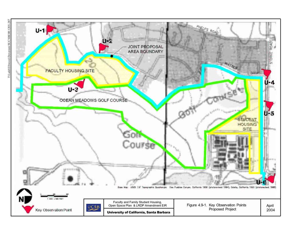
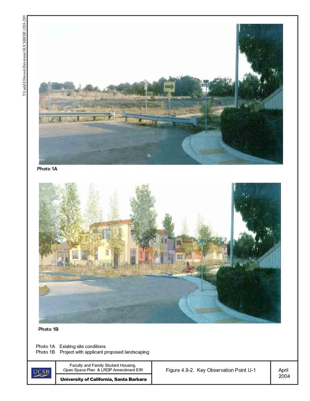
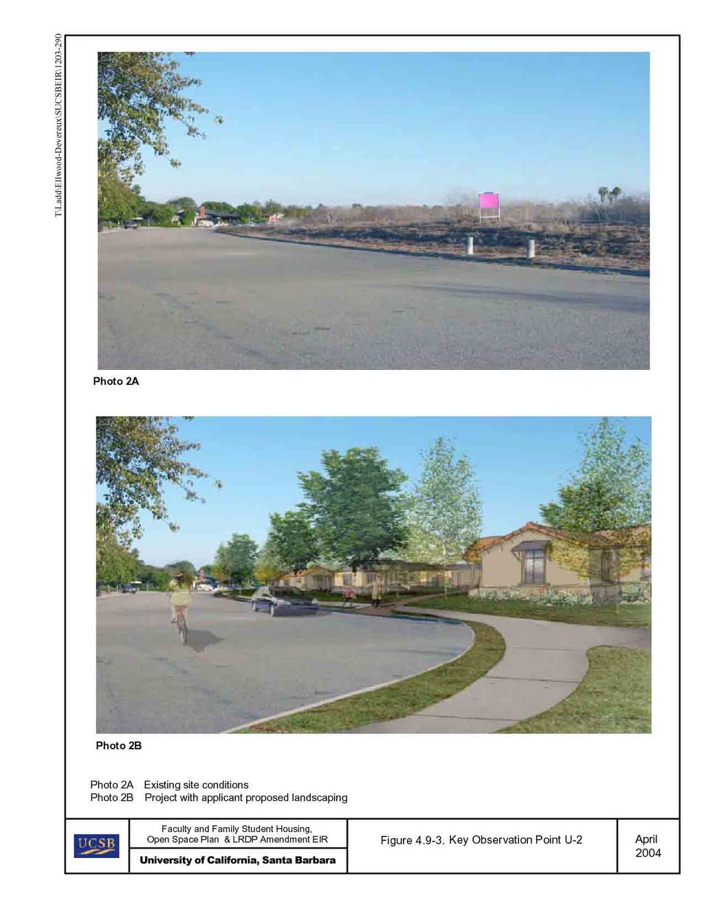
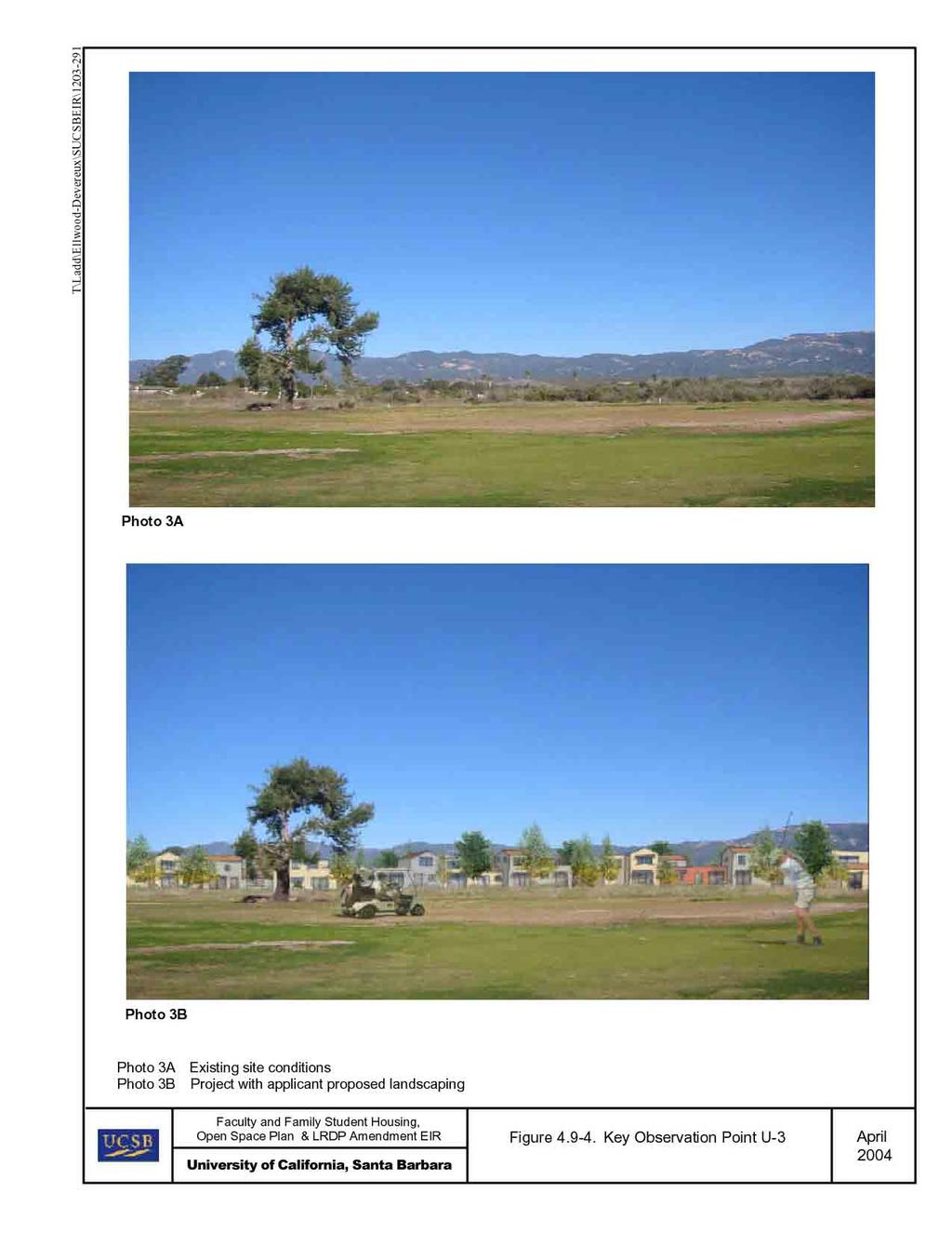
4 trees, the Ellwood Marine Terminal in the COPR Expansion Area is a somewhat prominent visual feature, with large metal tanks, access roads, security fencing and utility lines Scenic Vistas For the purposes of this EIR, scenic vistas may generally be described in two ways: panoramic views (visual access to a large geographic area of high scenic value, for which the field of view can be wide and extend into the distance) and focal views (visual access to a particular object, scene, setting, or feature of significant interest). Panoramic views are typically associated with vantage points that provide a sweeping geographic orientation and may include urban skylines, valleys, or mountain ranges. These views are typically available from a publicly accessible viewpoint, such as public gathering places. Surrounding views include vistas of the Santa Ynez Mountains, which form a dramatic backdrop to the north, and views of the Pacific Ocean to the south. Public views of these scenic resources, both the subject site and surrounding vistas, can be accessed from various locations, including along arterial streets such as Hollister Avenue and Storke Road, neighborhood streets, beaches, trails across undeveloped areas, and nature preserves such as the COPR. In general, views of the coastline and the Pacific Ocean are limited to areas nearest the coast (e.g., Coal Oil Point, West Campus Bluffs, and portions of the COPR). In other areas (e.g., West Campus Mesa and along Devereux Road), views of the coast are limited by topography, vegetation, and intervening structures (such as the Devereux School). Along Devereux Road, the Venoco Access Road and trails along the northern edge of the Coal Oil Point are scenic vistas that include views of the Devereux Slough, the COPR, and the Santa Ynez Mountains. Along the coast, views of the Santa Ynez Mountains are available from some locations, while views are blocked at other locations due to topography, vegetation, or structures. To the extent that the landform itself is considered a visual resource, development of the proposed project could provide additional view opportunities through the provision of additional buildings on campus. For purposes of this analysis, focal views are defined to include views of significant natural landforms, public art/signs, and visually important structures, such as historic buildings. Impacts related to the visual character or quality of the campus and the immediately surrounding area are discussed in Impact LRDP Key Observation Points Key Observation Points (KOPs) are locations selected to be representative of the most critical public locations from which the project will be seen. An initial review of baseline project data including project documentation and site background information was conducted in order to gain familiarity with the existing landscape, visual resource issues of concern, viewer sensitivity, and the characteristics of the proposed project and project alternative. Following data review, a field reconnaissance was conducted with representatives from the University. The selection of KOPs for the University project (and the South Alternative discussed in Chapter 6.0, 4.9-4
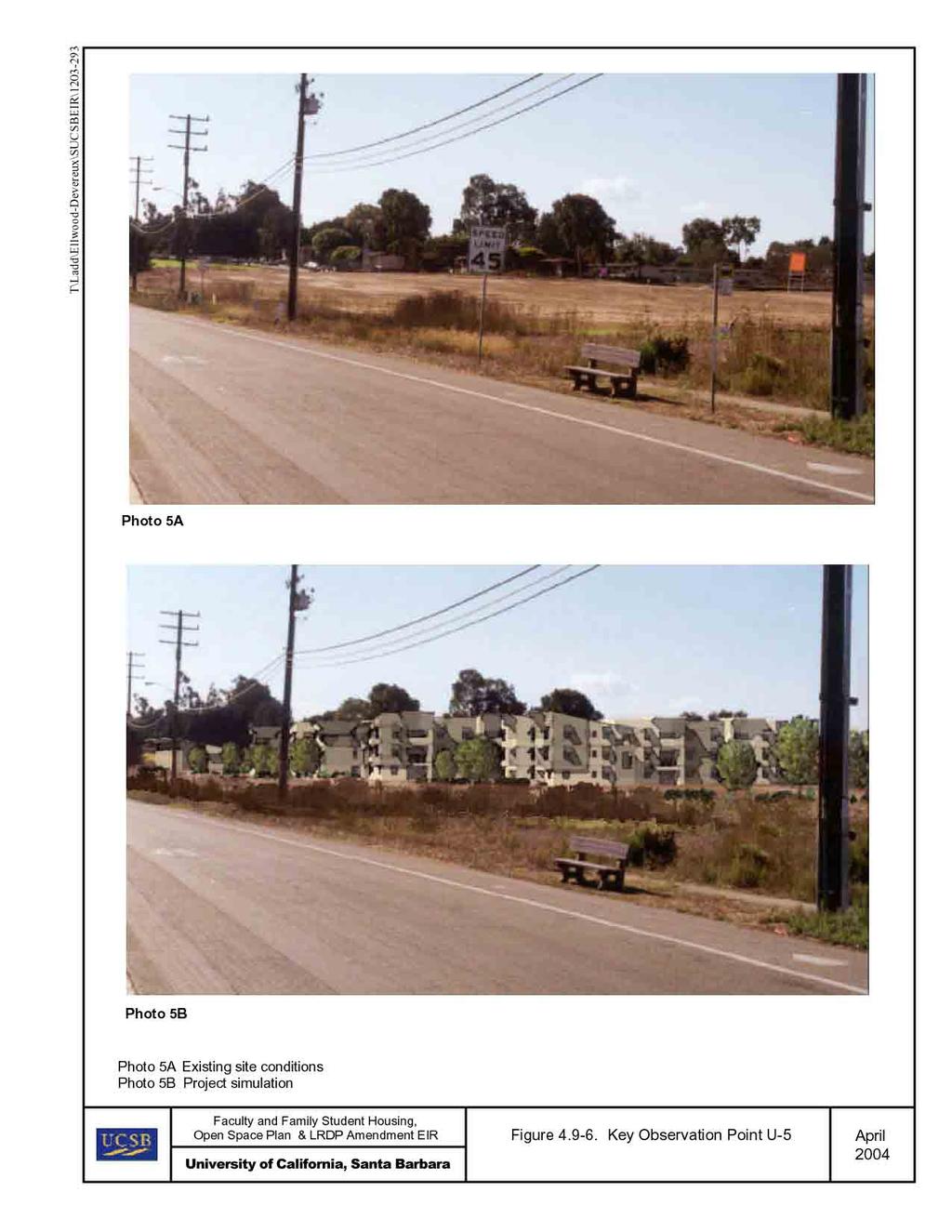
5 Alternatives) project alternative was made in the field by representatives of the University and the Cannon Associates, the visual resources consultant. The location of the KOPs for the visual analysis is shown on Figure The intent in KOP selection is to identify those locations in proximity to the project areas that best represent overall views toward the project as seen from public roads and other public places such as recreation areas and trails. KOPs are generally selected for one or two reasons: 1) the location provides representative views along a specific route segment or in a general location of interest; and/or 2) the viewpoint effectively captures the presence or absence of a potentially significant project impact in that location. KOPs are typically established in locations that provide high visibility to relatively large numbers of viewers and/or sensitive viewing locations such as recreation areas and vista points. While it is not possible to represent every possible view toward the project from such public areas, the KOPs identified are representative of typical impacts to visual resources generated by the proposed project and facilitate review and discussion of the proposed project. Key Observation Point U-1. View south toward the proposed North Campus Faculty Housing site north of Ocean Meadows Golf Course from the terminus of Phelps Road. Typical viewers at this location are residents of the neighborhood to the north of the site. Secondary viewers may be recreational users accessing the site and adjacent open space areas from public access points along Phelps Road. Key Observation Point U-2. View southeast toward the eastern portion of the proposed North Campus Faculty Housing site from the terminus of Marymount Way. Typical viewers at this location are residents of the neighborhood to the north of the site. Secondary viewers may be recreational users accessing the site and adjacent open space areas from Marymount Way. Key Observation Point U-3. View northeast from Ocean Meadows Golf Course toward the central portion of the North Campus Faculty Housing site north of Devereux Creek. Typical viewers at this location are recreational users of the golf course. Key Observation Point U-4. View southwest from Storke Road at the Whittier Drive intersection toward the eastern portion of the Sierra Madre Student Housing site. Typical viewers from this arterial road include residents of neighborhoods to the north, south, and east of the project site; University students and faculty; University visitors; and recreational users accessing nearby golf course, beach, and open space areas. Key Observation Point U-5. View southwest from Storke Road at the drainage swale and driving range of Ocean Meadows Golf Course toward the eastern portion of the Sierra Madre Student Housing site. Typical viewers from this location include residents of neighborhoods to the north, south, and east of the project site; University students and faculty; University visitors; and recreational users accessing nearby beach and open space areas
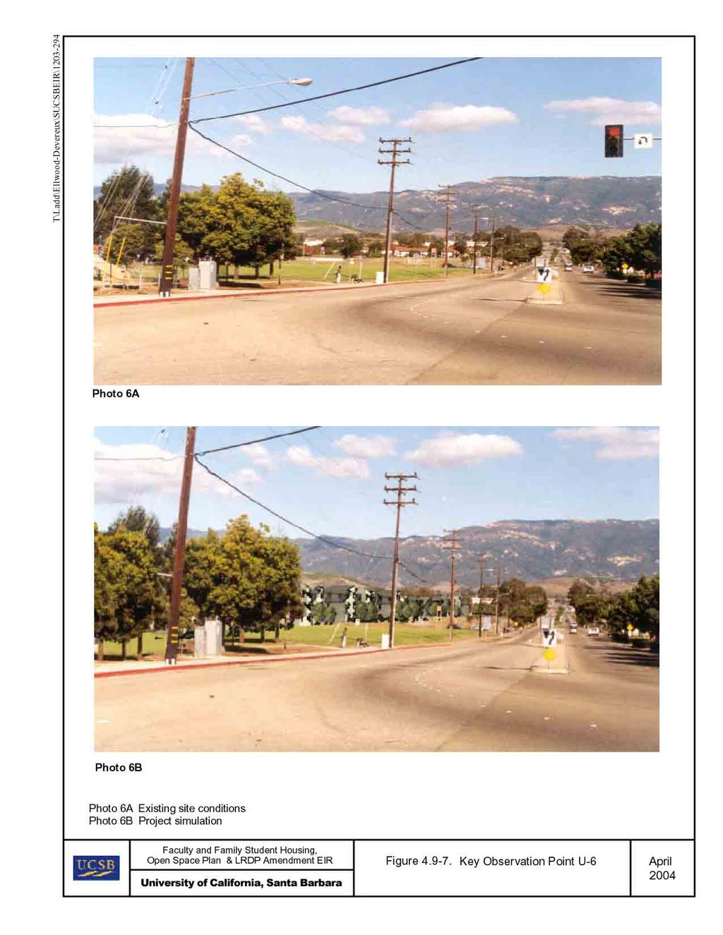
6 Key Observation Point U-6. View northwest from the intersection of Storke Road and El Collegio Road towards the southern portion of the Sierra Madre Family Student Housing. Typical viewers from this location include residents of existing West Campus (Student Family) Apartments, occupants of vehicles traveling along Storke Road, and recreational users accessing nearby beach and open space areas Sources of Light and Glare As most of the North and West Campuses are undeveloped, few sources of light and glare exist on the individual sites. Scattered development on the West Campus, including West Campus Point faculty housing, the (privately-owned) Devereux School, structures at Coal Oil Point, the Orafalea Children s Center, and Cameron Hall all have sources of night lighting, which varies from interior illumination to exterior security lighting of parking areas. As these various sources are scattered around the West Campus, much of this lighting is screened by trees, vegetation, and topography, resulting in low levels of lighting at dispersed locations. Most of the structures on the West Campus include glass windows, which may be sources of intermittent glare (e.g., when the sun angle is low), but do not include large expanses of glass, nor reflective glass on exterior building façades (e.g., mirrored glass). The West Campus Family Student Housing complex at Storke Road and El Collegio Road is a more visible source of night lighting, due to the proximity to Storke Road and the lack of significant landscaping at the edges of the complex. Interior sources of illumination and exterior security lighting along walkways and around parking facilities is generally visible from adjacent locations. Sources of lighting from the Ocean Meadows Golf Course include the clubhouse, the cart barn, and the existing residence located near the northwest corner of the West Campus Student Family Housing complex. Because of the minimal landscaping adjacent to these structures, nighttime illumination from these sources is visible from adjacent locations. The residential neighborhoods located north of Whittier Drive, Marymount Way, and Phelps Road represent the greatest source of nighttime illumination in the project area, primarily due to streetlights along roadways. Additional illumination is viewable from the interior and exterior lighting from homes along the southern perimeter of these residential neighborhoods Regulatory Framework There are no federal, state, or local regulations for aesthetics that are applicable to the University. Consistency with local policies related to visual resources is discussed in Section 4.8 (Land Use) and Section 7 (Relevant Plans and Policies)
7
8 4.9.4 Project Impacts and Mitigation Methodology The analysis of visual impacts focuses on the nature and magnitude of changes in the visual character of the University North and West Campuses due to the proposed residential and undeveloped area improvements, including the visual compatibility of the proposed improvements with on-campus and adjacent uses and public vantage points where visual changes would be evident, as well as impacts that could occur as a result of construction and the introduction of additional sources of light and glare in the project vicinity. EIP Associates performed field surveys during July and August 2003 to determine the existing visual character and context of the project area (e.g., visual compatibility, light and glare conditions, and publicly accessible vistas). For the purposes of this analysis, a scenic vista is considered a panoramic view with visual access to a large geographic area of high scenic value that extends into the distance from a publicly accessible viewpoint, such as public gathering places. A substantial adverse effect on a scenic vista would include the substantial obstruction of a panoramic view from a publicly accessible gathering place. Views from private property, including residences, are not considered scenic vistas for the purposes of this analysis. Analysis of potential damage to scenic resources, including trees, rock outcroppings, and historic buildings, is evaluated for those areas within or adjacent to any designated state scenic highway. The potential for degradation of visual character of the North Campus or West Campus and surroundings is evaluated in terms of a substantial adverse change in the visual character or quality, including a change in land use, development of currently undeveloped land, and the removal of a substantial number of mature trees. change that is compatible with existing patterns of development would not be considered to constitute a significant impact. Potential effects from new sources of light and glare are evaluated in terms of the potential for daytime glare (from reflective surfaces, such as glass) or from night lighting (and associated glare) to adversely affect views from land uses adjacent to the project area. For the purposes of this analysis, it is assumed that the project will incorporate relevant LRDP policies (identified below) into project design, siting, construction, or operation as appropriate. The incorporation of LRDP policies may reduce or avoid potentially significant impacts related to visual resources LRDP Policies The Coastal Act Element of the LRDP included a range of policies and standards (herein termed LRDP policies) to demonstrate consistency with the LRDP, and projects implemented under the LRDP, with the statutory requirements of Chapter 3 of the Coastal Act (commencing with Section 30200). The following LRDP policies are relevant to
9 New structures on the campus shall be in general conformance with the scale and character of surrounding development. Clustered developments and innovative designs are encouraged Buildings on Main and Storke Campus shall not exceed the height limits established in Figure 15 measured to the ridgeline, except for mechanical and electrical equipment (b). Buildings on North and West Campus shall not exceed 35 feet, except for student housing on North Campus, which shall not exceed 45 feet. Height restrictions are measured to the ridgeline and exclude mechanical and electrical equipment In order to preserve existing native trees and significant stands of trees which pre-date University acquisition of the campus, to the extent feasible, native trees shall be retained within the overall site area of new development Existing topography, vegetation and scenic features of the North and West Campus are to be retained and incorporated into the proposed development whenever possible Trees or shrubs may be selectively removed or trimmed to provide views to and along the ocean and scenic coastal areas along the primary view corridors identified in Figure 24 (1990 LRDP) or for safety reasons. Any removal of trees or shrubs shall be timed to avoid the nesting season of local birds (January through June) Specimen trees or groves which contribute to the visual attractiveness of North and West Campus may not be removed, unless necessary for safety reasons or to provide the least cleared area sufficient to locate and construct approved roads and structures on the site. Selective clearing of vegetation may be permitted where panoramic views may be presently obscured by such vegetation Contours of finished surfaces on West Campus are to be blended to achieve a consistent grade and natural appearance. Borders of cut slopes and fills are to be rounded off to a minimum radius of 5 feet so as to blend with the natural terrain A 200-foot vegetated buffer along the southern-most edge of North Campus will be re-vegetated to enhance its degraded visual quality Natural building materials and colors that are compatible with the surrounding landscape will be used where practical Native plantings to screen development from the two public access corridors (identified in Figure 3.0 of the North and West Campus Housing LRDP Amendment) will be used No development shall be permitted on the bluff face, except for staircases or access ways to provide public beach access and pipelines for instructional or research-oriented use
10 30240(b)4. All new lighting on the West Campus, Storke Campus, and Main Campus shall be kept at the minimum level which strikes a balance between safety and habitat protection, and shall be designed to avoid glare into adjacent properties Thresholds of Significance The following thresholds of significance are based on Appendix G of the CEQA Guidelines. For purposes of this EIR, implementation of the proposed project may have a significant adverse impact on agricultural resources if it would result in any of the following: Have a substantial adverse effect on a scenic vista Substantially damage scenic resources, including, but not limited to, trees, rock outcroppings, and historic buildings within a state scenic highway Substantially degrade the existing visual character or quality of the site and its surroundings Create a new source of substantial light or glare that would adversely affect daytime or nighttime views in the area Effects Not Found to Be Significant The Initial Study did not identify any visual resource (or aesthetic) impacts as Effects Not Found to Be Significant; therefore, all potential visual resource impacts (identified in Appendix G of the CEQA Guidelines) are discussed in this EIR Impacts and Mitigation Measures Impact Implementation of the proposed project would not have a substantial adverse effect on a scenic vista. This impact would be less than significant. Amendment of the LRDP to permit development of 236 units of faculty housing on the North Parcel and 151 units of family student housing on the Storke-Whittier Parcel would result in the development of residential structures up to 35 feet in height. Implementation of the portion of the Open Space Plan under the University s jurisdiction would result in coastal access improvements, including: 1) improvement of existing trails, 2) improvement of existing beach access points, 3) installation of a new coastal access stairway, 4) provision of additional public parking, and 5) replacement of an existing portable restroom. Implementation of coastal access improvements and habitat restoration would not block or otherwise substantially interfere with any scenic vistas and would result in the preservation of contiguous open space areas and improve access to such areas. Views of the Santa Ynez Mountains, which are currently available along the southern perimeter of the North Parcel, including the adjacent portions of the Ocean Meadows Golf Course, would not be blocked from the publicly accessible portions of the site adjacent to the University
11 Depending on the precise location of the proposed residential structures and the viewer, intermittent views of distant trees and undeveloped areas may be available, but most views across the North Parcel from existing residential areas along Phelps Road would be blocked, however, these views do not constitute a scenic vista as defined above. Figures and depict typical views that currently exist which would be blocked by development on the North Parcel. The views of the North Campus depicted in these figures do not constitute scenic vistas as defined above, and are primarily held from private residences north of the site. Views of the Santa Ynez Mountains, which are currently available along the southern perimeter of the North Parcel, including the adjacent portions of the Ocean Meadows Golf Course, would be partially blocked from the publicly accessible portions of the site (see Figure 4.9-4). However, the loss of any views across the North Parcel, including loss of views of undeveloped areas and of the Santa Ynez Mountains, would not represent a substantial adverse effect on a scenic vista, as they are not publicly held views as noted above. No other views of scenic vistas would be blocked by the proposed project, as illustrated by Figures through Therefore, as no impact would occur to scenic vistas, this impact would be less than significant. Improvement or formalization of existing trails would include installation of an appropriate surface (e.g., decomposed granite) and the use of natural or natural-appearing materials for signage and fencing consistent with the rural/natural character of the area. None of these improvements would block or substantially degrade any scenic vistas, due to the low height of signage and fencing, per the Open Space Plan. Trail closures would be accomplished with physical elements (fence, logs, rocks embedded into ground) in combination with signage indicating trail closure. As with trail improvements, use of physical barriers would not block or substantially degrade any scenic vistas in those areas subject to trail closures. Installation of access improvements, including boardwalks at selected locations along the coast and new coastal access stairways, per the Open Space Plan, may have low-height fencing to keep users on the boardwalk or stairway. The installation of low fencing or stair rails would not substantially interfere with any scenic vistas of the coastline and the Pacific Ocean. Passive or active habitat restoration methods, such as eliminating recreation activities or the installation of native plants, would generally replace existing non-native or invasive vegetation or result in bare ground being planted. Although these restoration methods could result in new trees that may, due to their eventual height, partially block scenic views, the location of new trees is expected to be intermittent, and thus no substantial adverse impacts to scenic views from restoration would result. Replacement of the restroom at Coal Oil Point would replace the existing portable restroom with a larger permanent facility in the same general location. The introduction of a slightly larger structure would not substantially block scenic views of the coastline or the Pacific Ocean that may be available from locations near the proposed restroom. The proposed new parking lot(s), either on the West Campus Mesa south of Cameron Hall, at Coal Oil Point, or on the West Campus Bluffs west of Camino Majorca, would be designed per the Open Space Plan. This
12
13
14
15
16
17
18 parking lot(s) would be designed with landscaped and low fencing as necessary to protect sensitive resources, and thus would not block any scenic views or vistas that may be available from adjacent publicly owned locations. Relative to focal views, there are no public outdoor art spaces on the North or West Campus. Significant stands of trees that acted as windrows related to historic use of the property predate the University s acquisition of the land. Implementation of MM 4.9-3(c) (under Impact below) would ensure preservation of existing native trees to the maximum extent feasible. The only historic building on North and West Campus is a barn, which is visible from limited locations of the West Campus Mesa, but views of this structure would not be affected by any development or open area improvements. The Devereux Slough can also be considered a scenic feature of the project area. Views of the Slough would not be affected by development under the proposed project. Implementation of the proposed project would not have a substantial adverse effect on a scenic vista and this impact would be less than significant. Impact Implementation of the proposed project would not substantially damage scenic resources, including, but not limited to, trees, rock outcroppings, and historic buildings within a state scenic highway. No impact would result. The University North and West Campuses are located approximately 0.5 mile south of U.S. Highway 101, and generally bounded by Storke Road, Whittier Drive, Marymount Way, and Phelps Road, none of which is officially designated or identified as eligible for designation as a state scenic highway (California Department of Transportation, 2003). The historic barn (discussed above), on-site stands of trees, or the Devereux Slough are not located within a state scenic highway. Implementation of the proposed project, including residential development and Open Space Area improvements, would not result in damage any scenic resources within a state scenic highway, and no impact would occur. Impact Implementation of the proposed project could substantially degrade the visual character or quality of the North or West Campus and the immediate surrounding area. With implementation of the identified mitigation measures, this impact would be reduced to a less-thansignificant level. Amendment of the LRDP to permit development of faculty housing on the North Parcel, family student housing on the Storke-Whittier Parcel, and implementation of the portions of the Open Space Plan under the University s jurisdiction could result degrade the visual character or quality of the North and West Campus and the surrounding area. Residential development and open space improvements would occur in undeveloped areas and on previously undeveloped sites. Therefore, visual quality impacts related to the general character of project sites (e.g., loss of open areas), components of their visual settings (e.g.,
19 architectural styles or mature landscaping), and the visual compatibility between proposed uses and adjacent land uses could occur. Determining the significance of visual impacts is inherently subjective, because individuals respond differently to changes in the visual characteristics of an area. As discussed earlier, the North Parcel is primarily vegetated with disturbed grasslands and intermittent shrubs, with various informal trails and barren spots in which the vegetation has been disturbed (or removed entirely) as a result of human and animal use. Development of residential structures on the North Parcel, implementation of Open Space Plan improvements, including trail improvements and trail closures, access improvements, and habitat restoration would result in development that is compatible with nearby residential development, and would not substantially degrade the visual character or quality of the area. Development of faculty housing would result in development on approximately 23 acres of the North Parcel. Development of the Sierra Madre Family Student Housing complex would result in grading of approximately 10.7 acres of land on the Storke-Whittier Parcel and an adjacent 2.8 acres on the existing West Campus Family Student Housing complex. Development of residential structures on the North Parcel and Storke-Whittier Parcel would result in the conversion of an undeveloped and disturbed area into the site of permanent residential structures, with parking integrated into, or adjacent to, the housing structures. The proposed sites of residential development are contiguous with adjacent residential land uses (e.g., housing north of Phelps Road, Marymount Way, and Whittier Drive, and east of Storke Road and the existing West Campus Family Student Housing complex). Consistent with LRDP policy , development of new housing would generally be compatible in scale and character with existing housing in the area and would entail clustered development. Implementation of the portion of the Open Space Plan under the University s jurisdiction would result the preservation and restoration of contiguous open space areas, as well as in coastal access improvements, including: 1) improvement of existing trails, 2) improvement of existing beach access points, 3) installation of a new coastal access stairway, 4) provision of additional public parking, and 5) replacement of an existing portable restroom. In addition, areas of degraded habitat would be restored. Improvement or formalization of existing trails would include installation of an appropriate surface (e.g., decomposed granite) and the use of natural or natural-appearing materials (such as fences, barriers, or signage) consistent with the rural/natural character of the area. As some existing trails would be widened, the visual presence of trails could be more prominent in some locations. However, given the extensive number of existing informal trails, the proposed improvement of selected trails, concurrent with the closure of other trails, would result in a net reduction in trails, and thus result in beneficial impacts associated with fewer discontinuous patches of native vegetation. Consistent with LRDP policy , no development is planned on the bluff face, except for staircases and access ways to provide public beach access. Installation of improved beach access,
20 OPEN SPACE PLAN, AND LRDP AMENDMENT EIR Since the existing tanks at the Ellwood Marine Terminal would continue to be used for the storage of hydrocarbon materials such as petroleum and oil, spills or accidental release of petroleum products may potentially occur in proximity to the proposed residential and recreational uses. These liquids and their associated vapors are flammable in nature, and there is an inherent risk for a fire or explosion in the event of an upset condition, which could lead to a release of chemicals into the environment. The results of a Quantitative Risk Assessment (QRA) of Platform Holly and the Ellwood Marine Terminal Facility concluded that the main risk to the population from the Ellwood Facility is due to the separation and storage of liquefied petroleum gas (LPG) and natural gas liquids (NGL). These gas liquids produce large flame jets or boiling liquid expanding vapor explosions (BLEVEs) that if released can affect a large area. The toxic risk was considered unacceptable based upon the County s Environmental Thresholds for public safety. A number of risk reducing measures were developed to reduce the overall risk from the Ellwood Facility. With the implementation of these measures, the public risk from the Ellwood Facility would be considered acceptable. In addition, Platform Holly does not store large quantities of flammable gas liquids and, therefore, has smaller hazard zones than the Ellwood Facility. Section 4.5 Hazards & Hazardous Materials Major hazardous materials accidents are extremely infrequent, and additional emergency response capabilities are not anticipated to be necessary, since no increase in the number of incidents that could result at the Ellwood Marine Terminal would result from project implementation. Since residential development would occur on the North Parcel and Storke- Whittier Parcel, in greater proximity to the EMT than existing residential developments, the proposed project increases the number of persons that would be exposed potential risks in the event of an accident or fire at the EMT. MM Per LRDP policy , should housing development occur south of the Ocean Meadows Golf Course, a minimum setback of 585 feet between the nearest Ellwood Marine Terminal storage tank and any proposed residential structures shall be maintained. Incorporation of the required setback would reduce potential risks associated with a fire or accident to an acceptable level of risk, based on foreseeable accident scenarios. In addition, the campus would comply with federal and State laws and regulations regarding hazardous materials by continuing to implement health and safety plans, programs, and procedures related to the use, storage, disposal, or transportation of hazardous materials, and provide for emergency clean-up response procedures to minimize the risk if an accidental exposure, release, or spill occurs. With implementation of MM 4.5-6, implementation of the proposed project would not expose the public to a significant hazard from foreseeable upset or accident conditions at the Ellwood Marine Terminal involving the release of hazardous materials into the environment, and this impact would be reduced to a less-than-significant level. Impact Project implementation would not result in construction on a site that is included on a list of hazardous materials sites compiled pursuant to Government Code Section
21 OPEN SPACE PLAN, AND LRDP AMENDMENT EIR Section 4.5 Hazards & Hazardous Materials , and, as a result, would not create a significant hazard to the public or environment. There would be no potential impact No impact would result. Amendment of the LRDP to permit residential development on the North Campus, coastal access improvements, and open space management activities, including habitat restoration, would not result in construction on a site that is included on a list of hazardous materials sites compiled pursuant to Government Code Section , and, as a result, would not create a significant hazard to the public or environment. Based upon review of federal, State, and County hazardous waste lists and databases pursuant to Government Code Section , one known hazardous materials site (the Ellwood Marine Terminal, or Venoco lease site) exists on the project site. The lists and databases include, but are not limited to, Federal ASTM standard known as the Resource Conservation and Recovery Act database (RCRIS-SQG list), federal ASTM supplemental known as the Facility Index System (FINDS list), and State ASTM standards known as the Department of Toxic Substances Control Hazardous Waste and Substances Site List (Cortese List) and the California Hazardous Material Incident Report System (CHMIRS list). These lists and databases contain information regarding asbestos waste, underground storage tanks, photoprocessing chemicals, PCBs, unspecified solvent and organic mixture wastes, unspecified aqueous solution, metal sludge, other hazardous materials monitored by statute or regulation, known releases of hazardous substances, locations where radioactive or other hazardous materials are stored or second-hand, facility information, and pointers to other sources of information that contain more detail. No portion of the project site was identified on the Cortese or CHMIRS lists; however, the Venoco Lease property was identified on the RCRIS-SQG list as well as the FINDS list. (EDR, 2003) The proposed project would result in development of faculty housing on the North Parcel and family student housing on the Storke-Whittier Parcel, and open space improvements on the South Parcel, the West Campus Mesa, West Campus Bluffs, Coal Oil Point, and the Coal Oil Point Reserve. No residential development, open space improvements, or other construction activities would occur within the Ellwood Marine Terminal area. Thus, the proposed project would not involve construction on any site that is included on a list of hazardous materials sites compiled pursuant to Government Code Section , and there would be no potential impact. Impacts associated with potential soil or groundwater contamination are addressed in Impacts and above. Impacts associated with abandoned oil wells in the project area are addressed in Impacts and above. Impacts associated with risk of upset from the existing Ellwood Marine Terminal operations are addressed in Impact above. Impact Project implementation would not result in a significant safety hazard for people residing or working in the project area associated with proximity to the Santa Barbara Municipal Airport. This impact would be less-than-significant. Amendment of the LRDP to permit residential development on the North Campus, coastal access improvements, and open space management activities, including habitat restoration,
22 OPEN SPACE PLAN, AND LRDP AMENDMENT EIR would not result in a significant safety hazard for people residing or working in the project area associated with proximity to the Santa Barbara Municipal Airport. Implementation of the proposed project would result in the development of faculty and student family housing, and open space improvements on undeveloped land within three miles west/southwest of the Santa Barbara Municipal Airport. The faculty housing site would be approximately 1.5 miles from the end of existing Runway 7/25 and 1.4 miles from the future terminus of the runway. The project site is entirely within the Airport Influence Area (AIA) and partially within the Approach Zone of the Santa Barbara Municipal Airport. A detailed discussion of land use compatibility of the proposed project with the airport is provided in section 4.6, Land Use, Impact Location of portions of the project area within the existing and future Approach Zone of Santa Barbara Municipal Airport may represent a safety hazards to residents of proposed housing. Section 4.5 Hazards & Hazardous Materials The proposed project would result in development of 236 faculty housing units within the North Parcel of North Campus. This portion of the proposed project would be located within the existing and future Approach Zone of the Santa Barbara Municipal Airport. Faculty housing would include single-family and multi-family residential development. Single-family construction of 60 units would not be considered a safety issue to the Airport Land Use Commission (ALUC). This use is considered a compatible land use from a safety standpoint within the Approach Zone, and is proposed on the easternmost portion of the North Parcel site, which is most proximate to the one-mile marker from the end of Runway 7. The project proposes construction of 176 multi-family units just west of the proposed singlefamily homes. According to the land use guidelines of the Airport Land Use Plan (ALUP), development on the North Parcel could create a hazard to future residents of this development through location of multi-family housing on a site within the Approach Zone. Multi-family housing is not considered a compatible land use from a safety standpoint within the Approach Zone, according to the ALUP; however, the proposed project does not require ALUP approval. The land use compatibility guidelines in the ALUP are based upon safety concerns. The guidelines are intended to limit concentrations of a large number of persons in the area. Due to the higher density of persons in multi-family units, this use would result in a larger concentration of persons on site. Thus, a larger number of persons would be exposed to potential hazards associated with aircraft overflight. However, the use of the residential units would not result in a hazard in and of itself. Rather, the concentration of persons on site resulting from higher density uses would expose more persons to potential hazards, should an incident occur, than would single-family construction. The probability that an incident would occur at the airport is low. There is a low rate of airplane accidents nationwide and strict compliance with all FAA regulations related to aircraft and pilot safety, such as pilot training, aircraft inspection and certification, and air traffic control, are intended to assure the continued safety of aircraft operations. Therefore, while the proposed project would not conform to land uses identified in
23 OPEN SPACE PLAN, AND LRDP AMENDMENT EIR Section 4.5 Hazards & Hazardous Materials the ALUP for safety, the incremental increased risk from location multi-family units within the Approach Zone compared to single-family units would not result in a significant safety hazard for people residing in the area. The proposed Sierra Madre Housing and Open Space Areas would be located within the AIA. Location within the AIA would require notification of the annoyances or inconveniences (i.e., noise, aircraft overflight) associated with proximity to Airport Operations. However, no safety constraints have been identified. Therefore, the Sierra Madre Housing and the Open Space Plan would not result in risks due to their location within proximity to the Santa Barbara Airport. The University also maintains an Emergency Operations Plan, which is designed with the intent to assist the University in preparation for, and response to, all levels of emergencies with minimal impact. With continued implementation of public safety and emergency operation procedures, proposed project would not result in a significant safety hazard for people residing or working in the project area associated with proximity to the Santa Barbara Municipal Airport, and this impact would be less-than-significant. Impact Project implementation could impair implementation of, or physically interfere with, an adopted emergency response or emergency evacuation plan. With implementation of identified mitigation measures, this impact would be reduced to a less than -significant level. Amendment of the LRDP to permit residential development on the North Campus, coastal access improvements, and open space management activities, including habitat restoration, could impair implementation of, or physically interfere with, an adopted emergency response or emergency evacuation plan. Construction and operation activities associated with development or the proposed project could potentially affect emergency response or evacuation plans due to temporary construction barricades or other obstructions that could impede emergency access on campus. During a response, the primary emergency access point to the South Parcel is the Venoco access road, along with Phelps Road through the Ocean Meadows Golf Course. Emergency access to the West Campus is via Devereux Road. Brush trucks can access the beach via the two main beach access points at Ellwood (with helicopter and marine rescue operations available as needed). Fire crews would utilize formalized trails to reach fires and to provide emergency response, including the provision of water for fire suppression, as there are no water hookups in the interior of the Open Space Areas. The primary emergency access point to the Sierra Madre student housing development would be Storke Road and to the North Parcel faculty housing development would be Storke Road via Phelps Road. In addition, vehicles can reach the North Parcel from Cannon Green via Hollister Avenue. Evacuation traffic can flow west and north, away from the North and West Campuses by turning east onto Phelps Road and then north onto Storke Road or by turning north onto Cannon Green Drive and then west onto Hollister Avenue. However, the primary emergency
24 The project will implement the concepts articulated in the Joint Proposal and the resultant Open Space Plan, which provide for the preservation and restoration of approximately 652 contiguous acres of open space and natural reserve. The Joint Proposal presents the opportunity to preserve and enhance the visual quality of the most of the Project area over the long-term, by clustering development adjacent to existing developed areas and by avoiding islands of development that area permitted by existing plans and policies, but would fragment the existing open space area and its visual character. Thus, from a cumulative perspective, implementation of the proposed project would result in a cumulative benefit to visual resources. With respect to the project site, sweeping views of the site are quite limited, and only exist within higher topographic locations to the east of the project site. However, because all residential development will be clustered immediately adjacent to existing residential development, rather than on the promontory headlands or other sensitive coastal bluff areas, the visual affect will be a seamless transition from existing to proposed residential, with the vast majority of the headlands remaining as permanent natural open space. Further, because open space would be preserved in the western portion of the site, views of the Pacific Ocean from the project site would be uninterrupted. The contribution of the proposed project to impacts associated with a substantial adverse effect on scenic vistas would not be considered cumulatively considerable and a less-than-significant impact would result. Other panoramic views include the mountains (the Santa Ynez Mountains) that form the eastern boundary of the coastal plain. Future development within the Santa Ynez Mountains is not anticipated to be extensive, and would not affect long-range panoramic views from the project site. Therefore, the cumulative impact would be less than significant. Further, the project itself would have no contribution to this impact. Focal views, which include visual access to a particular object, scene, setting, or significant feature of interest, such as heritage trees, a historic building, a piece or collection of outdoor artwork (i.e., public art or signs), a garden, or any other focused view, do not exist from the project site. (Cumulative impacts on historic buildings as a cultural resource are analyzed in Section 4.4 of this EIR, and are concluded to be less than significant.) Views from the site include adjacent residential development, the Ocean Meadows Golf Course, and panoramic views of the coastal headlands and the Santa Ynez Mountains, none of which would be considered focal views. Further, there are no focal views within or to the project site, as it is currently undeveloped. Because of the natural of focal views, which are site-specific, and the regulations imposed by the CEQA review process and local design review procedures, cumulative impacts are anticipated to be less than significant. Further, the project itself would have no contribution to this impact. Thought the project s contribution to cumulative visual impacts is not significant, it is possible that certain individual views of scenic resources in the cumulative context area, including trees and rock outcroppings, could be affected by cumulative development (as more details become known); however, this would occur on a site-by-site basis. It is anticipated that the protections afforded to natural scenic resources through the CEQA review process, scenic highway
Regional Overview, Existing Jurisdictions, and Governing Land Use Plans
 4.6 LAND USE 4.6.1 Introduction This section of the EIR describes existing land uses on the North and West Campuses and analyzes the potential for implementation of the proposed project to conflict with
Nob Hill Pipeline Improvements Project EIR
 Section 3.1 Aesthetics This section addresses the visual aspects that may affect the views experienced by the public, including the potential to impact the existing character of each area that comprises
SECTION 3.0 PROJECT DESCRIPTION
 3.1 INTRODUCTION SECTION 3.0 PROJECT DESCRIPTION The University of California, Santa Barbara (University) proposes to implement an LRDP Amendment for the University North and West Campuses, develop 236
5.1 AESTHETICS AND VISUAL RESOURCES Physical Setting
 5.1 AESTHETICS AND VISUAL RESOURCES 5.1.1 Physical Setting Aesthetic values are an important aspect in establishing the identity, sense of place, and quality of life in a community. Natural features in
3.10 LAND USE SETTING PROJECT SITE EXISTING LAND USE DESIGNATIONS AND ZONING. General Plan Land Use Designations.
 This section of the Draft EIR addresses the existing land uses on and adjacent to the project site and discusses the potential impacts of the proposed project on existing land uses. Key issues addressed
5.11 AESTHETICS ENVIRONMENTAL SETTING
 5.11 AESTHETICS ENVIRONMENTAL SETTING The lies on a relatively flat valley floor surrounded by rugged hills and mountains. The topography of the planning area is defined by the Box Springs Mountains and
3.1 AESTHETICS Background and Methodology
 3.1 AESTHETICS 3.1.1 Background and Methodology 3.1.1.1 Regulatory Context The California Environmental Quality Act (CEQA) requires that project sponsors evaluate the project s potential to cause aesthetic
4.10 RECREATION Introduction
 OPEN SPACE PLAN, & LRDP AMENDMENT EIR 4.10 RECREATION 4.10.1 Introduction This section describes existing recreational resources on the University s North and West Campuses, and analyzes whether the project
CHAPTER 10 AESTHETICS
 CHAPTER 10 AESTHETICS CHAPTER 10 AESTHETICS This section identifies and evaluates key visual resources in the project area to determine the degree of visual impact that would be attributable to the project.
IV.B. VISUAL RESOURCES
 IV.B. VISUAL RESOURCES ENVIRONMENTAL SETTING Existing Visual Character Project Site The project site is located at 17331-17333 Tramonto Drive in the Pacific Palisades community of the City of Los Angeles
The impacts examined herein take into account two attributes of aesthetic values:
 IV. ENVIRONMENTAL IMPACT ANALYSIS This section addresses the potential impacts to views and aesthetics as a result of the proposed Project at the Project Site and the development scenarios analyzed for
Draft Gaviota Coast Plan Chapter 7: Visual Resources
 Draft Gaviota Coast Plan Chapter 7: Visual Resources 11/28/2012 Long Range Planning Division Planning and Development Department County of Santa Barbara Page Intentionally Blank Cover Photo: Gaviota Morning
4.1 AESTHETICS/VISUAL RESOURCES
 4.1 AESTHETICS/VISUAL RESOURCES This section provides a discussion of the visual resources in and around the project site, with an emphasis on the visual character and scenic qualities of the Gaviota Coast
3.2 AESTHETICS/VISUAL QUALITY
 3.2 AESTHETICS/VISUAL QUALITY This section evaluates the potential impacts of the proposed project on the existing visual conditions within MTRP. Design features proposed to reduce or avoid adverse effects
3.1 Aesthetics, Light, and Glare
 3.1 3.1.1 Introduction This section describes the existing aesthetics, light, and glare setting and potential effects from project implementation on visual resources and the site and its surroundings.
Venice Pumping Plant Dual Force Main Project Draft EIR
 City of Los Angeles 5.9 LAND USE PLANS 5.9.1 Environmental Setting Venice Pumping Plant Dual Force Main Project Draft EIR The Project lies within the bounds of Los Angeles County and the City of Los Angeles.
California Department of Transportation, California Scenic Highway Program; Placer Vineyards Specific Plan EIR prepared by Placer County;
 3.1 AESTHETICS 3.1.1 INTRODUCTION This section describes the visual character of the project site and views from surrounding public areas. This section also evaluates the change to visual resources in
GENERAL PLAN CONSISTENCY ANALYSIS
 GENERAL PLAN CONSISTENCY ANALYSIS Prepared by Planning Staff 10/28/2013 APPLICABLE GOALS, POLICIES AND PROGRAMS FROM the LAND USE CHAPTER Goal LU-1 Policy LU-1.1 Policy LU-1.2 Goal LU-2 Protect the character
4.8 LAND USE AND PLANNING
 4.8 LAND USE AND PLANNING 4.8.1 INTRODUCTION This section describes existing and planned land uses at the Hayward campus and analyzes the impact of implementation of the proposed Master Plan on land uses
Coal Oil Point Reserve Management Plan LRDP Policy Consistency Analysis August Consistent. All applicable LRDP policies apply to the COPRMP.
 APPENDIX G LRDP CONSISTENCY TABLE Coal Oil Point Reserve Management Plan LRDP Policy Analysis August 2015 INTRODUCTORY POLICIES Policy INTRO-1 - The policies of the Coastal Act (PRC Sections 30210 through
U C S B OFFICE OF CAMPUS PLANNING & DESIGN. Notice of Impending Development. September Trailer 309, 320, and 327 Demolition Project
 U C S B OFFICE OF CAMPUS PLANNING & DESIGN E H T LET A U N IV E R SIT T H Y E R E 186 O F University of California Santa Barbara September 2013 Notice of Impending Development Trailer 309, 320, and 327
5. Environmental Analysis
 5.1 This section of the Draft Environmental Impact Report (DEIR) describes the existing landform and aesthetic character of the project area and discusses the potential impacts to the visual character
Visual Impact Assessment 830 Pratt Avenue St Helena, CA
 Visual Impact Assessment 830 Pratt Avenue St Helena, CA 1. Introduction The following aesthetic visual impact assessment has been prepared pursuant to the California Environmental Quality Act (CEQA). The
-MENDOCINO COUNTY PLANNING AND BUILDING SERVICES- DIVISION II OF TITLE 20--COASTAL ZONING CODE
 CHAPTER 20.504 VISUAL RESOURCE AND SPECIAL TREATMENT AREAS Sec. 20.504.005 Applicability. Sec. 20.504.010 Purpose. Sec. 20.504.015 Highly Scenic Areas. Sec. 20.504.020 Special Communities and Neighborhoods.
Environmental Setting, Impacts, and Mitigation Measures
 CHAPTER 3 Environmental Setting, Impacts, and Mitigation Measures Format of the Environmental Analysis The assessment of each environmental resource discussed in this chapter includes the following: Environmental
THE PLANNING AREA 2.1 PLANNING AREA LOCATION
 2. The Planning Area Brisbane Baylands Specific Plan 21 2 THE PLANNING AREA 2.1 PLANNING AREA LOCATION The Baylands is located approximately midway between San Francisco s central business district and
PARK CITY MUNICIPAL CODE TABLE OF CONTENTS TITLE 15 LAND MANAGEMENT CODE - CHAPTER 2.21
 PARK CITY MUNICIPAL CODE TABLE OF CONTENTS TITLE 15 LAND MANAGEMENT CODE - CHAPTER 2.21 TITLE 15 - LAND MANAGEMENT CODE CHAPTER 2.21 - SENSITIVE LAND OVERLAY ZONE (SLO) REGULATIONS 15-2.21-1. PURPOSE...1
4.1 AESTHETICS EXISTING ENVIRONMENTAL SETTING ALAMITOS BAY MARINA REHABILITATION PROJECT CITY OF LONG BEACH
 4.1 AESTHETICS This section provides a discussion of the existing visual and aesthetic resources on site and in the surrounding area as well as an analysis of potential impacts from implementation of the
4.1 AESTHETICS. A. Regulatory Framework
 4.1 This section includes a description of the existing visual setting of the project site and an analysis of the effects the proposed project would have on aesthetics in the project vicinity. Aesthetics
URBAN DESIGN GOALS / POLICIES / MEASURES
 URBAN DESIGN GOALS / POLICIES / MEASURES GOALS / POLICIES Authority Consideration of urban design issues in the general plan is provided under the Land Use Element requirements which direct attention to
4.1 AESTHETICS AND VISUAL QUALITY
 SCOPE AND METHODOLOGY 4.1 AESTHETICS AND VISUAL QUALITY This section evaluates the potential impacts to aesthetics and visual quality. Aesthetics refers to visual resources and the quality of what can
Visual and Aesthetics
 Such a connection could accommodate timed transfers and improve connections between local transit service and Presidio Shuttle service. Level of Service The results of the analysis are provided on a route-by-route
3.5 VISUAL AND AESTHETIC QUALITIES
 3.5 VISUAL AND AESTHETIC QUALITIES 3.5.1 Introduction to Analysis 3.5.1.1 Summary of Results The Preferred Alternative would represent a minimal change to the visual character of the existing rail corridor.
IV. ENVIRONMENTAL IMPACT ANALYSIS B. AESTHETICS 1. VIEWS
 IV. ENVIRONMENTAL IMPACT ANALYSIS B. AESTHETICS 1. VIEWS ENVIRONMENTAL SETTING Existing Visual Character Project Site The project site is located at 10250 Wilshire Boulevard in the Westwood community of
4.0 AFFECTED ENVIRONMENT AND ENVIRONMENTAL CONSEQUENCES
 4.0 AFFECTED ENVIRONMENT AND ENVIRONMENTAL CONSEQUENCES The following sections discuss the impacts associated with environmental resources for the tunneling method Alternatives A and B. The construction
3.1 AESTHETICS AND VISUAL RESOURCES
 3.1 AESTHETICS AND VISUAL RESOURCES This section examines the potential for the proposed Project to create aesthetic and visual impacts as defined by the California Environmental Quality Act (CEQA) as
WESTSIDE SUBWAY EXTENSION PROJECT. Addendum to the Visual and Aesthetic Impacts Technical Report
 PROJECT to the Visual and Aesthetic Impacts Technical Report August 2011 Visual and Aesthetic Impacts Technical Report SUMMARY On October 28, 2010, the Metro Board selected the Westwood/VA Hospital Extension
Town of Portola Valley General Plan. Nathhorst Triangle Area Plan
 Town of Portola Valley General Plan Amended December 10, 1997 Table of Contents Introduction... 1 Planning Area... 1 Objectives... 2 Principles... 2 Standards... 4 Description... 4 Community Commercial...
4.1 AESTHETICS WATSON INDUSTRIAL PARK ENVIRONMENTAL IMPACT REPORT EXISTING CONDITIONS
 This Subsection describes the aesthetic qualities and visual resources present on the Project site and in the site s vicinity and evaluates the potential effects that the Project may have on these resources.
Gold Line Bus Rapid Transit Transit Oriented Development (BRTOD) Helmo Station Area Plan
 Helmo Station Area Plan") Appendix F Gold Line Bus Rapid Transit Transit Oriented Development (BRTOD) Helmo Station Area Plan Introduction and Purpose of the Plan The Gold Line Bus Rapid Transit facility is an eleven-mile dedicated
Appendix F Gold Line Bus Rapid Transit Transit Oriented Development (BRTOD) Helmo Station Area Plan Introduction and Purpose of the Plan The Gold Line Bus Rapid Transit facility is an eleven-mile dedicated
Department of Community Development. Planning and Environmental Review Division Revised Notice of Preparation
 Department of Community Development Michael J. Penrose, Acting Director Divisions Building Permits & Inspection Code Enforcement County Engineering Economic Development & Marketing Planning & Environmental
6.3 VISUAL RESOURCES. Landscape Character
 6.3 VISUAL RESOURCES 6.3.1 Affected Environment The DMR discussion is divided into two areas, DMR and Dillingham Trail, which would extend from SBMR to DMR. The ROI includes all areas within the line of
RZC Public View Corridors and Gateways
 RZC 21.42 Public View Corridors and Gateways 21.42.010 Purpose 21.42.020 Scope and Authority 21.42.030 Administration 21.42.040 Gateways Design 21.42.050 Unidentified Public Views 21.42.060 Identification
Silverlakes Equestrian Sports Park Draft Environmental Impact Report
 Silverlakes Equestrian Sports Park Draft Environmental Impact Report Aesthetics 4.1 - Aesthetics 4.1.1 - Introduction This section describes the existing aesthetic setting and potential effects from project
Chapter 5: Natural Resources and Environment
 NATURAL RESOURCES AND ENVIRONMENT 5-1 5 Chapter 5: Natural Resources and Environment BACKGROUND AND INTENT Urban expansion represents the greatest risk for the future degradation of existing natural areas,
U C S B OFFICE OF CAMPUS PLANNING & DESIGN. Notice of Impending Development. January Segovia Road Access Project
 U C S B OFFICE OF CAMPUS PLANNING & DESIGN E H A UNIVERSIT T Y LET T H E RE 186 OF BE 8 LIGH T CALIFORNIA University of California Santa Barbara January 2013 Notice of Impending Development Segovia Road
Glenn Highway MP DSR. Landscape Narrative
 Glenn Highway MP 34-42 DSR Landscape Narrative Project Landscape Goals The Glenn Highway MP 34-42 Project extends through a variety of landscape types typical to the Matanuska-Susitna Valley. In general,
12.0 LAND USE AND PLANNING
 This section describes the existing and proposed land uses and land use designations on each of the project sites and surrounding properties, and analyzes the potential for the project to conflict with
5.1 AESTHETICS, LIGHT, AND GLARE
 This section describes the existing aesthetic resources in the Project area and discusses potential impacts associated with implementation of the proposed Project. The analysis focuses on the anticipated
HALF MOON BAY LOCAL COASTAL PROGRAM. d), JOHN M. St>NGER ASSOCIATES INC S.F.' CA EIOO VISUAL RESOURCES OVERLAY.
, JOHN M. St>NGER ASSOCIATES INC S.F.' CA EIOO VISUAL RESOURCES OVERLAY.") VISUAL RESOURCES OVERLAY Old Downtown Jl&& Scenic Hillsides Ocean Views from Highway 1 HALF MOON BAY LOCAL COASTAL PROGRAM d), JOHN M. St>NGER ASSOCIATES INC S.F.' CA. 94114 EIOO 217 CHAPTER 7: VISUAL
VISUAL RESOURCES OVERLAY Old Downtown Jl&& Scenic Hillsides Ocean Views from Highway 1 HALF MOON BAY LOCAL COASTAL PROGRAM d), JOHN M. St>NGER ASSOCIATES INC S.F.' CA. 94114 EIOO 217 CHAPTER 7: VISUAL
6.1 Aesthetics Introduction
 SECTION 6.0 ENVIRONMENTAL ANALYSIS 6.1 Aesthetics 6.1.1 Introduction The aesthetic quality of the proposed Project is determined by its visual character, consisting of elements such as natural and man-made
4.1 AESTHETICS Environmental Setting
 4.1 AESTHETICS This section of the Focused Tiered Final EIR presents potential aesthetic impacts of the Creative Arts and Holloway Mixed-Use Project (Project). Preparation of this Focused Tiered Final
I. INTRODUCTION... 1 II. PROJECT DESCRIPTION... 1 III. PROCEDURE... 2 IV. CONSISTENCY WITH THE 1990 LONG RANGE DEVELOPMENT PLAN...
 NOTICE OF IMPENDING DEVELOPMENT UNIVERSITY OF CALIFORNIA, SANTA BARBARA East Gate Vegetation Removal Project Table of Contents I. INTRODUCTION... 1 II. PROJECT DESCRIPTION... 1 III. PROCEDURE... 2 IV.
Draft TISCORNIA ESTATE SPECIFIC PLAN/EIR
 Draft TISCORNIA ESTATE SPECIFIC PLAN/EIR Submitted CONTENTS 1. PLAN SUMMARY II. INTRODUCTION IX. SPECIFIC PLAN RELATIONSHIPS X. XI. List of Figures 1. Regional Location 2. Point Richmond Area 3. Planning
UNIVERSITY OF MICHIGAN:
 Chapter Eight UNIVERSITY OF MICHIGAN: North Campus I. Introduction The University of Michigan currently owns approximately 800 acres of land in the northeast section of Ann Arbor. North Campus refers to
SECTION 2.0 INTRODUCTION
 SECTION 2.0 INTRODUCTION 2.1 PURPOSE AND SCOPE OF THE EIR Environmental Impact Reports (EIR) are informational documents which wil inform public agency decision-makers and the public generally of the significant
East Panorama Ridge Concept Plan Amendment
 Page 1 of 7 L003 : East Panorama Ridge Concept Plan Amendment Corporate NO: L003 Report COUNCIL DATE: March 4, 2002 REGULAR COUNCIL LAND USE TO: Mayor & Council DATE: February 27, 2002 FROM: General Manager,
SECTION 5.1 Aesthetics, Light, and Glare
 SECTION 5.1 Aesthetics, Light, and Glare 5.1 AESTHETICS, LIGHT, AND GLARE Visual resources information for this section was compiled from photographs and site surveys conducted by RBF Consulting. The purpose
Description of Preferred Alternative
 Chapter 2 Description of Preferred Alternative 2.1 Introduction This chapter of the programmatic Sammamish Town Center Sub-area Plan Final EIS provides a more detailed description of the Preferred Alternative
4.8 Landform Alteration and Aesthetics
 4.8 Landform Alteration and Aesthetics 4.8 LANDFORM ALTERATION AND AESTHETICS This section describes the potential environmental effects related to temporary and permanent impacts to landform and aesthetics,
CHAPTER 4 ENVIRONMENTAL SETTING AND IMPACT ANALYSIS
 CHAPTER 4 ENVIRONMENTAL SETTING AND IMPACT ANALYSIS SECTION 4.1 AESTHETICS AND VISUAL RESOURCES CHAPTER 4 ENVIRONMENTAL SETTING AND IMPACT ANALYSIS 4.1 AESTHETICS AND VISUAL RESOURCES 4.1.1 Existing
2.0 AREA PLANS. Lakeside Business District. Lakeside Business District Land Use Categories:
 Lakeside Business District Lakeside Business District Land Use Categories: Campus Commercial Campus Commercial means a mixture of uses which includes corporate offices, office parks, hotels, commercial,
Glenborough at Easton Land Use Master Plan
 Land Use Framework November 30, 2007 2.0 LAND USE FRAME- WORK 2.1 LAND USE HISTORY and Setting Glenborough at Easton is located on property that was used for mining in the 19th and 20th centuries and rocket
ENBRIDGE GAS DISTRIBUTION INC. Proposed Relocation for Ninth Line, Markham and Whitchurch-Stouffville. Environmental Screening Report
 Page 1 of 18 ENBRIDGE GAS DISTRIBUTION INC. Proposed Relocation for Ninth Line, Markham and Whitchurch-Stouffville Environmental Screening Report July 2011 Page 2 of 18 Table of Contents 1.0 INTRODUCTION
OP Council Resolution June 16, Planning and Development Services
 OP-08-01 Council Resolution June 16, 2008 Planning and Development Services Kingsgate Landing Outline Plan Table of Contents 1.0 Introduction 1 1.1 Purpose of Plan 1 1.2 Plan Area Location 1 1.3 Ownership
1.0 Circulation Element
 5/9/18 1.0 Circulation Element 1.1 Introduction As growth and development occur in Apache County, enhancements to its circulation system will be necessary. With time, more roads will be paved and air and
5.0 MITIGATION MEASURES ADOPTED PURSUANT TO THE 2004 FEIR FOR THE 2004 LRDP...5-1
 Faculty and Family Student Housing, Open Space Plan, and LRDP Amendment EIR Addendum TABLE OF CONTENTS 1.0 INTRODUCTION...1-1 1.1 PROJECT INFORMATION...1-2 1.2 SUMMARY OF NEW INFORMATION AND REVISIONS
ARTICLE IV: DEVELOPMENT STANDARDS 404 MASTER PLANNING
 IV 13 404 MASTER PLANNING Master Planning through the Site Analysis (Master Planning Site Analysis) or Planned Development (Master Planning Planned Development) is provided to encourage development which
APPENDIX C. Architectural and Environmental Design Standards. Environmentally sensitive areas should be protected.
 APPENDIX C Architectural and Environmental Design Standards Environmentally Sensitive Areas Goal A. Environmentally sensitive areas should be protected. Development, such as roads, houses, and other structures,
No comments related to land use and planning issues were received in response to the Notice of Preparation.
 4.8 LAND USE AND PLANNING This section analyzes the impacts relative to land use and planning that would occur as a result of implementation of the proposed Facilities Master Plan (proposed project). This
City of Lafayette Study Session Staff Report Design Review Commission
 ++ City of Lafayette Study Session Staff Report Design Review Commission Meeting Date: January 08, 2018 Staff: Subject: Chris Juram, Planning Technician SS12-17 Miramar Homebuilders, R-20 Zoning: Request
Staff Report and Recommendation
 Community Planning and Development Planning Services 201 W. Colfax Ave., Dept. 205 Denver, CO 80202 p: 720.865.2915 f: 720.865.3052 www.denvergov.org/cpd TO: City Council Neighborhoods and Planning Committee
File No (Continued)
") (Continued) Request for: (1) a Site Plan Review; (2) a Variance (to build on a significant ridgeline); (3) an Oak Tree Permit (to encroach into the protected zone of 25 oak trees and for potential thinning
(Continued) Request for: (1) a Site Plan Review; (2) a Variance (to build on a significant ridgeline); (3) an Oak Tree Permit (to encroach into the protected zone of 25 oak trees and for potential thinning
4.8 Land Use and Planning Environmental Setting Impacts and Mitigation Measures References...4.
 TABLE OF CONTENTS 4.8 Land Use and Planning...4.8-1 4.8.1 Environmental Setting...4.8-1 4.8.2 Impacts and Mitigation Measures...4.8-5 4.8.3 References...4.8-11 FIGURES Figure 4.8-1 Figure 4.8-2 Figure
Dwelling Units Max 12 dwelling units per acre/min 8 dwelling units per acre. Development Mix 80% non residential/20% residential
 13. OSTEEN LOCAL PLAN Background: The Osteen Local Plan area is located in southwest Volusia County along the SR 415 corridor between Lemon Bluff Road and Acorn Lake Road and includes 3,990 acres. The
CHAPTER 10-D GREATER MONTEREY PENINSULA AREA PLAN
 CHAPTER 10-D GREATER MONTEREY PENINSULA AREA PLAN GREATER MONTEREY PENINSULA AREA PLAN SUPPLEMENTAL POLICIES 1.0 - Land Use GMP-1.1 GMP-1.2 GMP-1.3 GMP-1.4 GMP-1.5 GMP-1.6 GMP-1.7 The County shall overlay
STAFF REPORT FOR STANDARD COASTAL DEVELOPMENT PERMIT #CDP FEBRUARY 26, 2015 CPA - 1 PO BOX 238 APTOS, CA 94001
 STAFF REPORT FOR STANDARD COASTAL DEVELOPMENT PERMIT #CDP 2014-0030 FEBRUARY 26, 2015 CPA - 1 OWNER/APPLICANT: AGENT: REQUEST: HANS HEIM PO BOX 238 APTOS, CA 94001 JAMES HAY PO BOX 762 MENDOCINO, CA 95460
Glenborough at Easton Land Use Master Plan
 Public Facilities 102 7.0 PUBLIC FACILITIES 7.1 OVERVIEW This chapter describes the public facilities that will provide high-quality services in the Glenborough at Easton community, to include three schools,
A. WHAT IS A GENERAL PLAN?
 I. Introduction A. WHAT IS A GENERAL PLAN? A general plan is the planning guideline for the future of a city. It contains goals and policies which regulate urban development, the protection of the natural
COMMISSION ACTION FORM
 ITEM #: 6 DATE: 09-06-17 COMMISSION ACTION FORM REQUEST: Introduction and Initial Review of Proposed Amendments to the Ames Urban Fringe Future Land Map for the North Growth Gap Area BACKGROUND INFORMATION:
Ten Mile Creek Planning Area
 PLANNING AREA POLICIES TEN MILE CREEK Ten Mile Creek Planning Area Location and Context The Ten Mile Creek Planning Area ( Ten Mile Creek area ) is located south of the current Boise AOCI, generally south
Master Plan Objectives and Policies
 Master Plan Objectives and Policies Introduction This chapter identifies the Park issues and recommended policies established by this Master Plan. The issues were identified through meetings with staff,
SENSITIVE LANDS OVERLAY
 SENSITIVE LANDS OVERLAY Chapter 22 Sensitive Lands Overlay 22.1 PURPOSE 22.2 APPLICATION AND ANALYSIS REQUIREMENTS 22.3 SENSITIVE LAND REGULATIONS 22.4 ADMINISTRATIVE PROVISIONS 22.5 DESIGN STANDARDS 22.6
4. INDUSTRIAL 53 CASTLE ROCK DESIGN
 4. INDUSTRIAL 53 CASTLE ROCK DESIGN CASTLE ROCK DESIGN 54 4. INDUSTRIAL Overview Well-designed and attractive industrial centers are the product of blending economic realities with both functional and
General Location Annex, Rezone & Preliminary Plat Lansdowne Addition, Unit Three
 NEWFOUNDLAND I-5 Agricultural District Subject Site SUNDANCE ANDERSON Single Family Residential CHRISTY PUD Agricultural District Highway Business General Location Annex, Rezone & Preliminary Plat Lansdowne
APPENDIX C SPECIAL PLANNING AREAS
 SPECIAL PLANNING AREAS There are five Special Planning Areas (SPAs) on the Land Use Diagram (Figure LU-2). The SPAs are areas with significant new growth potential that require more detailed subsequent
Appendix E Section 4(f) Evaluation
 Evaluation") Appendix E Section 4(f) Evaluation Appendix E Draft Section 4(f) Evaluation E.1 Introduction This appendix addresses a federal regulation known as Section 4(f), which protects parks, recreation areas,
Appendix E Section 4(f) Evaluation Appendix E Draft Section 4(f) Evaluation E.1 Introduction This appendix addresses a federal regulation known as Section 4(f), which protects parks, recreation areas,
Mollers Lane, Leopold, Victoria Significant Landscape Overlay Re-assessment
 XURBAN Mollers Lane, Leopold, Victoria Significant Landscape Overlay Re-assessment For: TGM Group November 2016 Final Mollers Lane, Leopold, Victoria Significant Landscape Overlay Re-assessment Client
Section 3.16 Visual Quality
 Chapter 3 Affected Environment, Environmental Consequences, and Mitigation Measures Section 3.16 Visual Quality Introduction This section discusses existing conditions, effects and mitigation measures
Scenic Resources Revised 7/19/2011
 1 Scenic Resources Revised 7/19/2011 Affected Environment The existing characteristic landscape of the Kiowa and Rita Blanca National Grasslands includes high mesas, dissected plateaus, deep canyons, volcanic
APPENDIX A 6 CONCEPTUAL PRELIMINARY PLAN GUIDE AND CHECKLIST FOR MAJOR SUBDIVISIONS CARRBORO DEVELOPMENT GUIDE APPENDIX A
 6 CONCEPTUAL PRELIMINARY PLAN GUIDE AND CHECKLIST FOR MAJOR SUBDIVISIONS Conceptual Preliminary Guide/Checklist for Major Subdivisions Page 1 FORM: REVIEW DATE: CONCEPTUAL PLAN REVIEW 2000 REVIEWED BY:
ENVIRONMENTAL IMPACT ANALYSIS
 IV. ENVIRONMENTAL IMPACT ANALYSIS A. AESTHETICS This section addresses the potential impacts to aesthetics and views that could result from the proposed project, including development of the Add Area,
F. Driveways. Driveways which provide access to off-street parking or loading from public streets shall comply with the following:
 Section 20.945.040 General Design Standards for Surface Parking Areas. A. Review Authority. Parking lot design and drainage shall be subject to review and approval of the City Transportation Manager. B.
Policy I-G-7: Public access to the Bay for the scenic enjoyment of the open water, sloughs, and marshes shall be protected.
 3.3 AESTHETICS Introduction This section describes the existing aesthetic resources and visual characteristics of the Project site and its immediate vicinity, along with existing plans and policies that
APPENDIX D: Visual and Aesthetic Conditions for NCCU Station Refinement. Durham-Orange Light Rail Transit Project
 APPENDIX D: Visual and Aesthetic Conditions for NCCU Station Refinement Durham-Orange Light Rail Transit Project October 2016 1. Introduction The Combined FEIS/ROD summarizes the effects of the D-O LRT
3.1 This evidence is based on the landscape and visual impact assessment included in Chapter 10 and Appendix I of the EIS.
 LANDSCAPE & VISUAL 1 QUALIFICATIONS AND EXPERIENCE 1.1 My name is Raymond Holbeach and I am a Regional Director for RPS Planning & Environment with full responsibility for management of the RPS Belfast
Introduction Environmental Setting. Visual Character. Surrounding Land Uses. Regional Setting. Project Site
 Contra Costa County Tassajara Parks Project Recirculated Draft EIR Aesthetics, Light, and Glare 3.1 - Aesthetics, Light, and Glare 3.1.1 - Introduction This section describes the existing aesthetics, light,
Land Use and Planning
 9 Land Use and Planning This chapter describes existing land uses, the General Plan land use classification and zoning designation of the Project sites, and applicable General Plan policies. The chapter
McCormick Pit Category 1 Class A License, Pit Below Water For Blueland Farms Limited. Visual Impact Assessment Report February 2013
 McCormick Pit Category 1 Class A License, Pit Below Water For Blueland Farms Limited Visual Impact Assessment Report February 2013 TABLE OF CONTENTS EXECUTIVE SUMMARY... v 1.0 BACKGROUND... 1 Figure 1.
III. PROJECT DESCRIPTION
 III. PROJECT DESCRIPTION A. PROJECT LOCATION Regional Setting The project site is located in the southeast quadrant of the City of Chico in Butte County, California and is comprised of four parcels totaling