Arana Gulch Park Master Plan
|
|
|
- Elaine Campbell
- 5 years ago
- Views:
Transcription


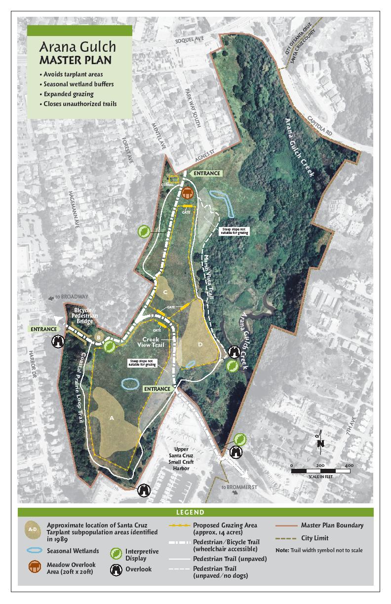
1 809 Center Street, Santa Cruz, CA Arana Gulch Park Master Plan Executive Summary The Arana Gulch Master Plan completes the last master planning work for the parks and open spaces within the City of Santa Cruz. The Plan has evolved from various planning and management efforts spanning many years. Throughout this process, considerable public interest and participation coupled with scientific surveys and evaluations have contributed to the development of this plan. A copy of the Arana Gulch Master Plan is included in the front sleeve of this packet for your review. The intent of the Master Plan is to establish a vision and goals that will shape the future of Arana Gulch as a unique open space within the City of Santa Cruz. This Master Plan identifies limited recreational uses, maximizes interpretive opportunities, and provides significant resource management guidelines to direct enhancement of the natural areas. It includes a resource and constraints analysis, analyzes existing uses and impacts, prescribes creation of a more appropriate formal trail system, eliminates existing environmentally damaging trails, and establishes resource management guidelines for each unique area. This Master Plan is a balance between public access and resource protection in an environmentally sensitive habitat area (ESHA). Recognizing the importance and priority of providing habitat protection, and access that is dependent on and sensitive to the resources on site, the Plan is designed to meet Coastal Act Policies. Currently this open space, which is situated in the middle of our urban environment, is impacted by volunteer trials through Santa Cruz tarplant habitat and other sensitive habitats. At the same time the open space is not accessible to people with limited mobility. Two very clear goals of the City, implemented by this plan, are to develop interpretive programs to foster stewardship of our natural environments and to provide multi-use trails to provide ADA access in this open space. The combination of many funding sources provides the financial resources to successfully implement the master plan. 1
2 Project Setting Arana Gulch is a natural area situated along the eastern boundary of the City of Santa Cruz, to the north of the Santa Cruz Harbor. This 67.7 acre City-owned open space features unique natural resources such as coastal prairie, Santa Cruz Tarplant, and the riparian and wetland habitat areas of Arana Gulch Creek. Overlooking the upper Harbor, a coastal terrace comprises the central portion of Arana Gulch. Grassland covers the expanse of the terrace, with oak woodland along the bluff edges. On the eastern portion of the property, the grassland gives way to riparian scrub and forest, sloping down to the broad floodplain of Arana Gulch Creek. Hagemann Gulch, a steep wooded canyon, forms the southwestern boundary of the property. Several unimproved earthen trails, most of which existed prior to the City s ownership, provide existing public access within Arana Gulch. The main trail, eroded and steep in some sections, provides an unofficial bicycle/pedestrian connection from Agnes Street at the north end to the Upper Harbor to the south. A pedestrian trail encircles the grassland area. There are no trail entrances or connections along the eastern or western boundaries of the property. There are also no existing wheelchair accessible trails within Arana Gulch. In addition to the designated trails, there are numerous unauthorized trails crossing the property, several of which are located in the southern grassland and tarplant population areas. Dogs are required to be on-leash at all times within Arana Gulch. The northernmost portion of the Santa Cruz Harbor property features an existing dry storage area, enclosed in chain link fencing. The designated southern access to Arana Gulch is located along the western edge of the dry storage area. There is also an informal, undesignated pathway along the northern boundary of the dry storage area which is used by some members of the public as a cut-through connection to Arana Gulch. There are no existing structures, parking or restrooms within Arana Gulch. There is limited fencing and park signage. Site History The project site was once part of the ranchlands known as Live Oak Ranch in the late 1800s. Cattle were grazed on the portion of the property now known as Arana Gulch. In the 1920s, the Arana Gulch property became the site of the East Side Dairy. The dairy operation continued through the mid-1950s. A barn and other structures were once located within the northern portion of the property, but were demolished after the mid- 1970s. Within the Arana Gulch property, no historic buildings or remnants exist from either the Live Oak Ranch or dairy operations. Foundations remain from some of the structures associated with the East Side Dairy, but these are not considered significant historic resources. Cattle grazing continued on the property until the late 1980s. In 1994, the City of Santa Cruz acquired the 63-acre property known as Arana Gulch. Years prior to that purchase, the City had acquired a narrow strip of land in the central portion of the property (approximately 4.7 acres). This strip of land was originally 2
3 intended for a roadway extension between Broadway and Brommer Street, but the City later decided not to pursue the roadway connection and has included all of the property as open space within the Arana Gulch Master Plan. Shortly after the acquisition of Arana Gulch, the City opened the property to limited public use, with the City Parks and Recreation Department managing the area. In 1997, the City Council approved the Arana Gulch Interim Management Plan, which outlined limited actions to maintain the property but did not include any land use decisions. Most of Arana Gulch has been designated as critical habitat for Santa Cruz tarplant. Since the purchase, the City has provided various tarplant management regimes, including mowing, raking, light scraping, and limited controlled burns. It is known that the tarplant thrived on the property when it was grazed during the dairy operations. Since that time, even with City and volunteer efforts, the tarplant has experienced a severe decline. Proposed Project Overview The City of Santa Cruz is submitting a consolidated coastal development permit application for the Arana Gulch Master Plan and trail improvements within the upper Santa Cruz Harbor. The Master Plan addresses the long-term use and resource management of the 67.7 acre City-owned Arana Gulch open space property. Most of the Arana Gulch property and upper Harbor area is located within the Coastal Zone. The coastal terrace portion of Arana Gulch is under local permitting jurisdiction, while the Arana Gulch and Hagemann Gulch Creek corridors are deemed tidelands and public trust lands within original Coastal Commission jurisdiction. The Santa Cruz City Council unanimously approved the Arana Gulch Master Plan and certified the associated Final Environmental Impact Report (EIR) in July A local coastal permit was not considered at that time. A legal challenge was subsequently filed against the Final EIR, in which the Court ruled in favor of the City in the proceeding under CEQA. A subsequent appeal was filed and the appellate court upheld the trial court s decision in favor of the city. Specifically, the coastal development permit application includes the following project components: Protection and management of habitat areas (coastal prairie/santa Cruz tarplant, Arana Gulch Creek and riparian area, seasonal wetlands, and Hagemann Gulch riparian woodland); improvement of portions of the existing trail system within Arana Gulch to provide Americans with Disabilities Act (ADA) compliant public access; installation of a pedestrian/bicycle bridge spanning Hagemann Gulch to provide a new west entrance; interpretive program displays and trail signage; 3
4 4
5 installation of grazing fencing associated with restoration of coastal prairie/santa Cruz tarplant habitat; and removal and restoration of unauthorized environmentally damaging volunteer trails. Most of Arana Gulch would remain undeveloped, with a focus on protection and enhancement of the sensitive habitat areas. The paved trails would comprise less than 1% of the total area of the Arana Gulch property. No on-site parking or restrooms are proposed as part of the project. Visitors may either walk or bicycle to Arana Gulch from the adjacent neighborhoods or park on public streets at the north, south and west entrances. Public restrooms are located at Frederick Street Park and the adjacent Harbor. Coastal Commission Consideration of Arana Gulch Master Plan On March 11, 2010 the City of Santa Cruz presented a Draft Arana Gulch Master Plan to the California Coastal Commission for the first time. Coastal Commission staff provided a comprehensive staff report that recommended approval of the Master Plan. City representatives requested the hearing be continued to allow the City opportunity to bring additional information back to the Commission related to their questions. On October 14, 2010 the City presented additional analysis in response to the questions and concerns raised at the March 11, 2010 hearing. Coastal Commission staff provided a comprehensive staff report, again recommending approval of the Arana Gulch Master Plan. Coastal Commissioner s took testimony and deliberated and by a 5-5 vote denied the coastal development permit. This is a new Coastal Development Permit application. As presented the project has been modified to: Further consolidate or eliminate trails and pathways. Move all existing and proposed pathways out of historic tarplant areas. Substantially expand the areas that may be grazed for habitat enhancement. Move fencing out of historic tarplant areas. Expand and maximize opportunities for Interpretive Programs. Provide additional funding for project and clearly describe the sources. Set aside a portion of the total plan funding in a City Trust Fund specially designated for long-term habitat management. Clarify and further describe parameters and development of the proposed Habitat Management Plan and its implementation Provide permeable all-weather surface for the multi-use trails. Coastal Commission staff also recommended in their staff report for the October 14, 2010 hearing, that the north-south multi-use trail from Agnes Street be moved to the westerly project boundary. This option would further expand the area for grazing in the northerly site, and is shown on the following map. However, this also puts the ADA-accessible trail to the periphery of Arana Gulch rather than providing an access experience into the property in the northern area. While the City is amenable to this change, the preference is for the multi-use trail to remain in the same alignment as the former farm road in the middle of the northern section, and the unpaved path would be on the periphery. 5
6 6
7 Project Highlights The Arana Gulch Master Plan includes numerous elements that are designed to protect the resources while providing public access, and interpretive themes and programs. The City project team has worked with Coastal Commission staff, resource agencies, biologists, native plant experts and advocates, and local nonprofits to provide the best possible balance between resource protection and public access. Through this process many aspects of the Master Plan have been enhanced and/or modified. Some of these are included in the list of highlights which follows: Habitat Management and Restoration A key component of the Plan is to develop and implant an Adaptive Management Plan for restoring and enhancing the native habitats, especially that of the Santa Cruz tarplant with a more aggressive recovery regime. The tarplant management plan will be developed and reviewed by a team of qualified botanists, including representatives from responsible agencies (Coastal Commission, California Department of Fish and Game, and US Fish and Wildlife Service), a botanist representing the California Native Plant Society, and two other non-agency biologists. The content and parameters of the Habitat Management Plan will be consistent with the details provided in the Master Plan and the list of requirements provided by Coastal Commission staff, including a baseline assessment, description of goals, procedures and timing for treatments, success criteria, reporting and modification of plan if warranted. Santa Cruz tarplant thrived on the site in the past when it was actively grazed. The City has increased its mowing regime in recent time in order to reduce invasive species, until a more focused plan with grazing can be commenced. Interpretive Programs The Interpretative Program includes displays at key locations, on such topics as invasive plant species and habitat restoration, historical use of the property, and watershed stewardship. The Interpretive Program provides an opportunity for docents to lead walks, classes and workshops by local experts to educate interested groups. The Plan allows the development of a Docent-led School Program administered by the Museum of Natural History that currently serves over 2,000 students and adults annually in other open space areas of the City. As well, O Neill Sea Odyssey runs an ocean stewardship program for youth at the adjacent harbor, and would include Arana habitats and watershed in their curriculum. The Interpretative Program provides an opportunity to further engage neighbors and other groups to support restoration work and lead walks, similar to efforts by neighborhood groups in other areas of the City. Some of these are coordinated by the Museum of Natural History and/or Parks and Recreation. 7
8 A pavilion area will be installed in the Agnes Street meadow that will include benches, an interpretive display, and oak plantings for shade. Funding The Santa Cruz City Council has committed long term funding of the Santa Cruz Tarplant Adaptive Management Plan and will place those funds in separate account of the City s Trust Fund. The County of Santa Cruz approved a resolution recommending approval of the Arana Gulch Master Plan and has committed $1.38 million dollars of Redevelopment funding to complete the project. The City is leveraging federal Transportation Enhancement (TE) funds to develop the multi-use trails for the project, as well as carry out the other project elements described, including habitat enhancement. TE funds are commonly used in this type of setting and for this purpose. Trails and Pathways The Plan provides trail connections to adjacent neighborhoods, as well as providing a spur trail to the Monterey Bay Sanctuary Scenic Trail and the California Coastal Trail. Both the paved and unpaved trails shown in the trail alignments avoid all areas of historic tarplant populations and seasonal wetlands. The spur trail between the central meadow and the Coastal Prairie Loop trail has been eliminated. The multi-use trails will be constructed as ADA accessible paths with a permeable all-weather surface of an integral color that blends with the site soils. Multi-use trails will provide public access for pedestrians and bicyclists, and provide access that does not currently exist for persons with physical limitations and those with children in strollers. Other pathways will be unimproved, but designed and maintained to guide people away from sensitive areas, and to minimize erosion and other environmental damage All unauthorized paths causing environmental damage will be removed. Interpretive opportunities are integral to the trail design. 8
9 Additional Information/Analyses Attached to the executive summary, Sections 2 through 6 have been provided to respond to questions from Coastal Commissioners, staff and interested members of the public. Those sections concern tarplant management, the interpretive program, cattle grazing, the funding program and a trail materials analysis and matrix. Appendices 20 through 29 contain the following analysis and mapping: 20. Habitat Fragmentation Discussion 21. Neary Lagoon Wildlife Refuge and Interpretative Trail System 22. Hydrology Report - drainage conditions adjacent to trail 23. Trail/Bikeway Examples Within Sensitive Habitat Areas 24. Arana Gulch Master Plan Team and Supporters 25. Boardwalk discussion/analysis 26. Caltrans funding requirements 27. Trial alignment alternatives Map 1 - Existing trails Map 2 - City proposed alignment Map 3 - Coastal staff recommendation (July 2010) Map 4 - CNPS alignment 28. Comparison Table between City and CNPS alternative alignments 29. Comparative Engineering Analysis AL City Trail alignment AL Cross Sections AL Slope Analysis (ADA) AL CNPS Trail Alignment AL Cross Sections AL-2.3 Slope Analysis (ADA) 9
Master Plan Objectives and Policies
 Master Plan Objectives and Policies Introduction This chapter identifies the Park issues and recommended policies established by this Master Plan. The issues were identified through meetings with staff,
3. VISION AND GOALS. Vision Statement. Goals, Objectives and Policies
 Vision Statement Queen Creek s interconnected network of parks, trails, open spaces and recreation opportunities provide safe and diverse activities and programs that sustain its unique, small town, equestrian
1. Parks & Recreation Neighborhood Parks Community Parks Special Use Sites 2. Open Space 3. Trails
 Appendix A: Park Classifications The intent of parks and recreation classifications is to aid in making acquisition and design decisions for park sites, facilities and the organization of recreation space
Burrowing Owl Habitat Project at the Albany Plateau. (a component project of the Gilman Street Playing Fields Project City of Berkeley) March 10, 2006
 March 10, 2006") Burrowing Owl Habitat Project at the Albany Plateau (a component project of the Gilman Street Playing Fields Project City of Berkeley) March 10, 2006 Submitted by The City of Berkeley Project history During
Burrowing Owl Habitat Project at the Albany Plateau (a component project of the Gilman Street Playing Fields Project City of Berkeley) March 10, 2006 Submitted by The City of Berkeley Project history During
COASTAL CONSERVANCY. Staff Recommendation March 25, 2004 LOS ANGELES GREEN VISION PLAN. File No.: Project Manager: Marc Beyeler
 COASTAL CONSERVANCY Staff Recommendation March 25, 2004 File No.: 04-014 Project Manager: Marc Beyeler RECOMMENDED ACTION: Authorization to disburse up to $50,000 to the University of Southern California
Study Area Map. Wasatch Hollow Open Space Restoration, Use, & Management Plan. Legend. Harrison Ave East. Roosevelt East.
 Harrison Ave Roosevelt Emerson «4 «5 Rosecrest 1900 East «3 1800 East Wasatch Hollow Open Space Restoration, Use, & Management Plan Study Area Map Legend «2 «1 Potential Access Location Emigration Creek
Policy & Procedure Effective Date: Parks Department Page of
 City of Arvada Policy & Procedure Effective Date: Parks Department Page of TITLE: City of Arvada Prairie Dog Habitat Plan APPROVAL: PURPOSE: To establish a plan for the preservation of black-tailed prairie
Chapter 5: Natural Resources and Environment
 NATURAL RESOURCES AND ENVIRONMENT 5-1 5 Chapter 5: Natural Resources and Environment BACKGROUND AND INTENT Urban expansion represents the greatest risk for the future degradation of existing natural areas,
Draft Stillwater 2030 Comprehensive Plan- Goals and Policies
 Draft Stillwater 2030 Comprehensive Plan- Goals and Policies Instructions- Review each goal and policy and discuss with group any changes, deletions for additions to the list using your groups pen. Keep
Memorandum Planning. Thursday, January 8, 2015
 Memorandum Planning Thursday, January 8, 2015 7.A. To: Coastal Advisory Committee From John Ciampa, Associate Planner Subject: Review Draft Local Coastal Program Copies: James Pechous, City Planner Purpose
Member Service Plan Sierra Nevada AmeriCorps Partnership
 Member Service Plan Sierra Nevada AmeriCorps Partnership Service plans lay the framework for what each Member will be doing during their service. Service plans detail the major projects and expected results
Yadkin River Greenway Feasibility Study Fact Sheet Village of Clemmons, Town of Lewisville, Town of Bermuda Run
 Fact Sheet Village of Clemmons, Town of Lewisville, Town of Bermuda Run Project Background The Yadkin River Greenway Feasibility Study is a joint project with the Village of Clemmons, the Town of Bermuda
COASTAL CONSERVANCY. Staff Recommendation December 13, 2007 COASTAL TRAIL AT LAND S END. File No Project Manager: Joan Cardellino
 COASTAL CONSERVANCY Staff Recommendation December 13, 2007 COASTAL TRAIL AT LAND S END File No. 07-086-01 Project Manager: Joan Cardellino RECOMMENDED ACTION: Authorization to disburse up to eight hundred
RECREATION, OPEN SPACE AND GREENWAYS ELEMENT GOALS, OBJECTIVES, AND POLICIES
 RECREATION, OPEN SPACE AND GREENWAYS ELEMENT GOALS, OBJECTIVES, AND POLICIES GOAL R-1: DEVELOP A RECREATION, OPEN SPACE AND GREENWAYS SYSTEM AS AN INTEGRAL COMPONENT OF AN OVERALL, COUNTY-WIDE ECONOMIC
COASTAL CONSERVANCY. Staff Recommendation June 5, 2008 SAN DIEGO RIVER TRIBUTARY CANYONS PROJECT. File No Project Manager: Megan Johnson
 COASTAL CONSERVANCY Staff Recommendation June 5, 2008 SAN DIEGO RIVER TRIBUTARY CANYONS PROJECT File No. 08-059 Project Manager: Megan Johnson RECOMMENDED ACTION: Authorization to disburse an amount not
The Illinois Department of Transportation and Lake County Division of Transportation. Route 173, including the Millburn Bypass
 The Illinois Department of Transportation and Lake County Division of Transportation welcome you to this Public Hearing for U.S. Route 45 from Illinois Route 132 to Illinois Route 173, including the Millburn
The following principles guide the development of goals and strategies to protect and promote these amenities:
 OPEN SPACE/PARKS/TRAILS/RECREATION GOALS/STRATEGIES Cherry Hills Village is a living environment that offers low density development, open areas, public scenic vistas, public trails and public parks. This
Lowe Park Master Plan Update Marion, IA August 25 th, 2011
 Lowe Park Master Plan Update Marion, IA August 25 th, 2011 Lowe Park Master Plan Update Concept Plan - June 1 st, 2011 Agenda 1 - INTRODUCTION Vision Statement Aerial of Existing Condition 2 MASTER PLAN
PLANNING AND NATURAL RESOURCES COMMITTEE. Public Access Conceptual Design Alternatives for the Red Barn Area of La Honda Creek Open Space Preserve
 PLANNING AND NATURAL RESOURCES COMMITTEE R-17-56 May 9, 2017 AGENDA ITEM AGENDA ITEM 2 Public Access Conceptual Design Alternatives for the Red Barn Area of La Honda Creek Open Space Preserve GENERAL MANAGER
April 11, 2016 Park Board Chair and Commissioners General Manager Vancouver Board of Parks and Recreation New Brighton Salt Marsh - Preferred Concept
 TO: FROM: SUBJECT: April 11, 2016 Park Board Chair and Commissioners General Manager Vancouver Board of Parks and Recreation New Brighton Salt Marsh - Preferred Concept RECOMMENDATION A. THAT the Vancouver
ADOPTION OF THE REVISED OPEN SPACE AND CONSERVATION ELEMENT OF THE GENERAL PLAN
 TO: FROM: SUBJECT: Honorable Mayor and City Council Planning Department ADOPTION OF THE REVISED OPEN SPACE AND CONSERVATION ELEMENT OF THE GENERAL PLAN RECOMMENDATION: It is recommended that the City Council:
RESPONSES TO PUBLIC CONCERNS AND QUESTIONS
 RESPONSES TO PUBLIC CONCERNS AND QUESTIONS Stations and Summary Questions for Public Meeting #2 June 23, 2015 General Questions / Concerns: 1. Is there any way this development can raise revenue for the
EIR Scoping Meeting MULTI-BENEFIT/MULTI USE PROJECT
 EIR Scoping Meeting MULTI-BENEFIT/MULTI USE PROJECT in Hahamongna Watershed Park July 12, 2012 and July 14, 2012 presented by City of Pasadena, Department of Public Works and Willdan Engineering Purpose
Coyote Hills Restoration and Public Access Project Coyote Hills Regional Park C o n c e p t P l a n a n d S i t e P r o g r a m
 Coyote Hills Restoration and Public Access Project Coyote Hills Regional Park C o n c e p t P l a n a n d S i t e P r o g r a m Chris Barton Environmental Programs Manager Aquisition Stewardship Development
ROBERT SIBLEY VOLCANIC REGIONAL PRESERVE LAND USE PLAN AMENDMENT COMMUNITY MEETING #2 NOVEMBER 16, 2016
 ROBERT SIBLEY VOLCANIC REGIONAL PRESERVE LAND USE PLAN AMENDMENT COMMUNITY MEETING #2 NOVEMBER 16, 2016 Presentation Overview Introduction Project Overview LUPA Project Status Technical studies Preliminary
Call for Artists for: Design and Construction of Environmental Art Activation Story Mill Community Park, Bozeman, MT
 Call for Artists for: Design and Construction of Environmental Art Activation Story Mill Community Park, Bozeman, MT Seeking artists to design, fabricate and install art elements in the nature sanctuary
3.10 LAND USE SETTING PROJECT SITE EXISTING LAND USE DESIGNATIONS AND ZONING. General Plan Land Use Designations.
 This section of the Draft EIR addresses the existing land uses on and adjacent to the project site and discusses the potential impacts of the proposed project on existing land uses. Key issues addressed
Mendota Heights 2040 Comprehensive Plan Draft Vers
 4 Parks and Trails The City of Mendota Heights boasts a variety of recreational and open space opportunities. Few cities can claim access to regional trails, riverside and lakeside parks, scenic bluffs
ADDENDUM TO BIOLOGICAL SCOPING SURVEY REPORT, BOTANICAL SURVEY AND WETLAND DELINEATION
 ADDENDUM TO BIOLOGICAL SCOPING SURVEY REPORT, BOTANICAL SURVEY AND WETLAND DELINEATION FOR AVALON INN (APN 069-241-27 & -04) 1201 & 1211 NORTH MAIN STREET FORT BRAGG, CA MENDOCINO COUNTY prepared for:
Hidden Pointe Landscape Master Plan. June, archi terra
 Hidden Pointe Landscape Master Plan June, 2006 t h e archi terra g r o u p 1 Table of Contents Background Purpose and Goals of the Master Plan Master Plan Process Existing Conditions Entrance Hidden Pointe
Errol Heights Park and Community Garden Frequently Asked Questions March 22, 2018
 Errol Heights Park and Community Garden Frequently Asked Questions March 22, 2018 Question 1: What improvements are planned for Errol Heights Park? How will the community be engaged in the process to shape
6 COMMUNITY SERVICES AND FACILITIES
 6 COMMUNITY SERVICES AND FACILITIES 6.1 PARKS AND OPEN SPACE The Hecker Pass Specific Plan provides over 98 acres of public parks and open space as shown in Figure 6-1. The bulk of this acreage is located
Section 3 INVENTORY OF RECREATION LAND AND FACILITIES
 Photo of Juan Bautista de Anza Park Section 3 INVENTORY OF RECREATION LAND AND FACILITIES Summary of Findings Park Definitions Summary of Recreation Facilities Other Recreation Facilities Nearby Recreation
Comanche Creek Greenway IMPROVEMENT PROJECT
 Comanche Creek Greenway IMPROVEMENT PROJECT City of Chico 2012 INTRODUCTION The City of Chico owns approximately 20 acres along Comanche Creek between Midway and the Union Pacific Railroad line, referred
Preliminary Sketch Plan for Fort Hunter Park
 Preliminary Sketch Plan for Fort Hunter Park Public Presentation November 19, 2009 Dauphin County Parks and Recreation 100 Fort Hunter Road Harrisburg, PA 17110 (717) 599-5188 www.dauphinc.org THOMAS COMITTA
City of Missoula and Missoula County Open Space Planning Open House
 City of Missoula and Missoula County Open Space Planning Open House FEBRUARY 6, 2018 The following slides contain the display board content from the open house. Please use boards to answer questions in
SCC PRD (2016) COUNTY PARK MASTER PLAN
 COUNTY PARK MASTER PLAN") SCC PRD (2016) COUNTY PARK MASTER PLAN MASTER PLAN UPDATE PARKS AND RECREATION COMMISSION NOVEMBER 7, 2018 PURPOSE OF THE MASTER PLAN The Sanborn County Park Master Plan will provide the Department with
SCC PRD (2016) COUNTY PARK MASTER PLAN MASTER PLAN UPDATE PARKS AND RECREATION COMMISSION NOVEMBER 7, 2018 PURPOSE OF THE MASTER PLAN The Sanborn County Park Master Plan will provide the Department with
2 PLANNING AREA DESCRIPTION
 2 PLANNING AREA DESCRIPTION 2.1 LOCATION Hecker Pass is located within the City of Gilroy near the western city limit. Figure 2-1 illustrates the regional location of the Hecker Pass Area. Figure 2-1:
Description of Preferred Alternative
 Chapter 2 Description of Preferred Alternative 2.1 Introduction This chapter of the programmatic Sammamish Town Center Sub-area Plan Final EIS provides a more detailed description of the Preferred Alternative
3.0 PROJECT DESCRIPTION
 3.0 PROJECT DESCRIPTION 3.1 BACKGROUND Under California law (Government Code Section 65300 et seq.), every city and county is required to have a general plan. The general plan is to be comprehensive and
& SUSTAINABILITY PLAN
 Chapter 6: IMPLEMENTATION, MANAGEMENT, & SUSTAINABILITY PLAN Overview The Oxbow Park and Zollman Zoo Master Plan presents a long-term vision for the park. While phasing of improvements is suggested, Olmsted
ORDINANCE NO WHEREAS, the recommendations from the Pinellas County Local Planning Agency have been received and considered.
 ORDINANCE NO. 16-55 AN ORDINANCE OF THE COUNTY OF PINELLAS, AMENDING THE FUTURE LAND USE AND QUALITY COMMUNITIES ELEMENT OF THE PINELLAS COUNTY COMPREHENSIVE PLAN TO ADOPT THE CRYSTAL BEACH COMMUNITY OVERLAY;
Philip A. Ginsburg, General Manager Toks Ajike, Acting Planning and Capital Program Director
 Date: March 7, 2018 To: Through: From: Subject: Recreation and Park Commission Capital Committee Philip A. Ginsburg, General Manager Toks Ajike, Acting Planning and Capital Program Director Dan Mauer,
SECTION FOUR: MISSION STATEMENT, GOALS & OBJECTIVES
 SECTION FOUR: MISSION STATEMENT, GOALS & OBJECTIVES Chapter Summary Chapter Ten: Mission Statement, Goals & Objectives To fulfill its mission, the Parks and Recreation Commission has identified four basic
Pinellas County Greenways
 Pinellas County Greenways USING GREENWAYS TO LINK OPEN SPACES The Florida Greenways Commission has defined a greenway as...a corridor of protected open space that is managed for conservation and/or recreation.
CITY OF BEACON NOTICE TO LANDSCAPE ARCHITECTS GENERAL INFORMATION AND REQUEST FOR PROPOSALS
 CITY OF BEACON NOTICE TO LANDSCAPE ARCHITECTS GENERAL INFORMATION AND REQUEST FOR PROPOSALS The City of Beacon (the CITY) is issuing this Request for Proposals (RFP) for the selection of a landscape architect
BISCUIT RUN PARK MASTER PLAN
 BOARD OF SUPERVISORS November 14, 2018 BISCUIT RUN PARK MASTER PLAN COUNTY OF ALBEMARLE ANHOLD ASSOCIATES Contents Project Introduction Property Background County Park Planning Process Existing Site &
F. The following uses in the HR District: attached single-family dwellings, condominiums, and institutional uses; and
 1102 DESIGN REVIEW 1102.01 PURPOSE AND APPLICABILITY Section 1102 is adopted to provide standards, criteria, and procedures under which design review may be approved. Design review is required for: A.
STREAM BUFFERS
 88-415 STREAM BUFFERS 88-415-01 PURPOSE In the Kansas City region and throughout the nation, vegetated stream buffers have been clearly shown to protect stream stability and related infrastructure, improve
BENJAMIN BANNEKER PARK FRAMEWORK PLAN (PLAN ADOPTION)
") BENJAMIN BANNEKER PARK FRAMEWORK PLAN (PLAN ADOPTION) COUNTY BOARD MEETING DECEMBER 16, 2017 County Board Consideration: Adopt the Benjamin Banneker Park Framework Plan and Design Guidelines Framework
BENJAMIN BANNEKER PARK FRAMEWORK PLAN (PLAN ADOPTION) COUNTY BOARD MEETING DECEMBER 16, 2017 County Board Consideration: Adopt the Benjamin Banneker Park Framework Plan and Design Guidelines Framework
ADOPTED CAPITAL IMPROVEMENT PROGRAM BUDGET ARROYO PROJECTS
 ADOPTED CAPITAL IMPROVEMENT PROGRAM BUDGET ARROYO PROJECTS HAHAMONGNA FY 212-216 Capital Improvement Program Priority Description Total Estimated Costs Appropriated Through FY 211 Adopted FY 212 FY 213
Chapter 6. Overall Vision RECOMMENDATIONS. More Trail and Trail. Connections. Equal Access to Park. Facilities and Programs. Water Access.
 Overall Vision More Trail and Trail Connections Equal Access to Park Facilities and Programs Water Access Environment Variety Chapter 6 RECOMMENDATIONS Chapter 6 The following recommendations for park,
Long Branch-Wayne Local Park Renovation Project
 Montgomery Parks Long Branch-Wayne Local Park Renovation Project Community Meeting #2 September 20, 2016 Oak View Elementary School 7:00-9:00 PM Welcome / Team Introductions M-NCPPC (Montgomery Parks)
Planning and Building Inspection Department Mitigation Monitoring Reporting Plan (MMRP) Potrero Subdivision Santa Lucia Preserve
 Potrero Subdivision Santa Lucia Preserve") Planning and Building Inspection Department Mitigation Monitoring Reporting Plan (MMRP) Potrero Subdivision Santa Lucia Preserve Project Name: Potrero Area Subdivision File No: PLN010001 APNs: 239-102-001-000;
Planning and Building Inspection Department Mitigation Monitoring Reporting Plan (MMRP) Potrero Subdivision Santa Lucia Preserve Project Name: Potrero Area Subdivision File No: PLN010001 APNs: 239-102-001-000;
1.0 Circulation Element
 5/9/18 1.0 Circulation Element 1.1 Introduction As growth and development occur in Apache County, enhancements to its circulation system will be necessary. With time, more roads will be paved and air and
STAFF REPORT FOR STANDARD COASTAL DEVELOPMENT PERMIT #CDP FEBRUARY 26, 2015 CPA - 1 PO BOX 238 APTOS, CA 94001
 STAFF REPORT FOR STANDARD COASTAL DEVELOPMENT PERMIT #CDP 2014-0030 FEBRUARY 26, 2015 CPA - 1 OWNER/APPLICANT: AGENT: REQUEST: HANS HEIM PO BOX 238 APTOS, CA 94001 JAMES HAY PO BOX 762 MENDOCINO, CA 95460
TOWN OF BETHLEHEM MEETING SUMMARY LOCAL WATERFRONT REVITALIZATION PROGRAM UPDATE
 TOWN OF BETHLEHEM LOCAL WATERFRONT REVITALIZATION PROGRAM UPDATE MEETING SUMMARY Purpose: LWRP Update Public Workshop #3 Date and Time: October 24, 2017, 6:00 pm - 8:00 pm Location: Town Hall, 445 Delaware
ARROYO PROJECTS ADOPTED CAPITAL IMPROVEMENT PROGRAM BUDGET
 A RROYO P ROJECTS ADOPTED CAPITAL IMPROVEMENT PROGRAM BUDGET FISCAL YEARS 214-218 HAHAMONGNA Priority Description 1 Hahamongna Watershed Park - Implement Master Plan 211,6 211,6 (77565) 2 Hahamongna -
G. RECREATION AND OPEN SPACE ELEMENT. The following summarizes the Recreation and Open Space Element:
 G. RECREATION AND OPEN SPACE ELEMENT The purpose of the Element is to provide the framework and direction for a comprehensive system of public and private sites for recreation, including, but not limited
Courthouse Planning Area
 Courthouse Planning Area Current Reality The Courthouse Planning Area is the characterized by expansive suburbanscale residential areas as well as the community resource planned area of athletic, educational,
BUSINESS OF THE PLANNING COMMISSION OF THE CITY OF HALF MOON BAY AGENDA REPORT
 For meeting of: BUSINESS OF THE PLANNING COMMISSION OF THE CITY OF HALF MOON BAY AGENDA REPORT TO: FROM: Honorable Chair and Planning Commissioners Jill Ekas, Community Development Director Brittney Cozzolino,
RECREATION AND OPEN SPACE ELEMENT GOALS, OBJECTIVES, AND POLICIES
 RECREATION AND OPEN SPACE ELEMENT GOALS, OBJECTIVES, AND POLICIES Goal 7 To provide park facilities, recreation programs, and open space resources that are safe, adequate, and accessible to all City residents,
WASHINGTON COUNTY OREGON
 WASHINGTON COUNTY OREGON LONG RANGE PLANNING DIVISION North Bethany Subarea Stream Corridors: Existing Regulations In Oregon, there is a distinct difference between the land use rules that apply in rural
DRAFT SECTION 4(F) EVALUATION KOLLINER PARK
 EVALUATION KOLLINER PARK") DRAFT SECTION 4(F) EVALUATION I. DESCRIPTION OF SECTION 4(F) RESOURCE The Section 4(f) resource potentially affected by the proposed action is Kolliner Park. The Alternative B-1 and C bridge crossings
DRAFT SECTION 4(F) EVALUATION I. DESCRIPTION OF SECTION 4(F) RESOURCE The Section 4(f) resource potentially affected by the proposed action is Kolliner Park. The Alternative B-1 and C bridge crossings
APPENDIX A 6 CONCEPTUAL PRELIMINARY PLAN GUIDE AND CHECKLIST FOR MAJOR SUBDIVISIONS CARRBORO DEVELOPMENT GUIDE APPENDIX A
 6 CONCEPTUAL PRELIMINARY PLAN GUIDE AND CHECKLIST FOR MAJOR SUBDIVISIONS Conceptual Preliminary Guide/Checklist for Major Subdivisions Page 1 FORM: REVIEW DATE: CONCEPTUAL PLAN REVIEW 2000 REVIEWED BY:
PARKS AND RECREATION
 PARKS AND RECREATION WHAT YOU WILL FIND IN THIS CHAPTER: Background information on the development of the Park, Recreation, and System Plan (PRSP). General overview of Ellensburg s parks and recreation
Town of Sahuarita Open Space Plan Element. University of Arizona Planning Program Projects Team
 Town of Sahuarita Open Space Plan Element University of Arizona Planning Program Projects Team Introduction Planning students in the Planning Program Project Class Overall Goal Potential uses of $1.5 Million
Open Space, Natural Areas, Parks, and Recreation
 Open Space, Natural Areas, Parks, and Recreation WHAT ARE THE CITY S CURRENT VALUES? This section addresses open spaces, natural areas, parks and recreation, and stormwater multi-use projects under separate
Rocky Areas Project Guidance HABITAT
 Rocky Areas Project Guidance HABITAT Introduction Rocky habitats are surface areas dominated by exposed rock, such as mountain peaks, inland cliffs, buttes and rocky outcrops. In many cases, rocky areas
DRAFT FOR PUBLIC REVIEW. Game Plan for a Healthy City
 DRAFT FOR PUBLIC REVIEW 2018 Game Plan for a Healthy City 2 Denveright. Parks & Recreation Game Plan Draft for Public Review Draft for Public Review Executive Summary Game Plan Overview Executive Summary
Department of Community Development. Planning and Environmental Review Division Revised Notice of Preparation
 Department of Community Development Michael J. Penrose, Acting Director Divisions Building Permits & Inspection Code Enforcement County Engineering Economic Development & Marketing Planning & Environmental
METROPOLITAN COUNCIL 390 North Robert Street, St. Paul, MN Phone (651) ; TDD (651)
 ; TDD (651)") DATE: December 20, 2011 METROPOLITAN COUNCIL 390 North Robert Street, St. Paul, MN 55101 Phone (651) 602-1000; TDD (651) 291-0904 TO: Metropolitan Parks and Open Space Commission FROM: Tori Dupre, Senior
DATE: December 20, 2011 METROPOLITAN COUNCIL 390 North Robert Street, St. Paul, MN 55101 Phone (651) 602-1000; TDD (651) 291-0904 TO: Metropolitan Parks and Open Space Commission FROM: Tori Dupre, Senior
SAN RAFAEL GENERAL PLAN 2040 INTRODUCTION AND OVERVIEW
 SAN RAFAEL GENERAL PLAN 2040 INTRODUCTION AND OVERVIEW Steering Committee Presentation February 14, 2018 Purpose of General Plan Guide land use and development decisions Coordinate transportation, infrastructure,
APPENDIX D: PARKS AND RECREATION ACTION PLAN
 APPENDIX D: PARKS AND RECREATION ACTION PLAN Goals The following goals are specific to the development, maintenance, and operation of the existing parks in the Township, as well as the acquisition and
Planning for Staten. Habitat Restoration and Green Infrastructure. Island s North Shore
 Habitat Restoration and Green Infrastructure Planning for Staten Island s North Shore Community Board 1 March 1, 2018 NYC Parks Forestry, Horticulture, and Natural Resources Funded by the NYS Department
Planning for and Managing Open Space and Natural Areas
 Planning for and Managing Open Space and Natural Areas Increasingly, development proposals in Delaware include large amounts of open space and natural areas. While open space is important as a community
Mitchell Ranch South MPUD Application for Master Planned Unit Development Approval Project Narrative. Introduction
 Mitchell Ranch South MPUD Application for Master Planned Unit Development Approval Project Narrative Introduction Mitchell Ranch South is a proposed single family (detached) residential development on
5. Father Hennepin Blufs Park and Hennepin Island Father Hennepin Bluffs Park Supporting Initiatives (see Figure 36): 7-22
: 7-22") 5. Father Hennepin Blufs Park and Hennepin Island As described in existing conditions portion of Chapter 2, Father Hennepin Blufs Park lies on the upland portion of the park and Hennepin Island spans the
5. Father Hennepin Blufs Park and Hennepin Island As described in existing conditions portion of Chapter 2, Father Hennepin Blufs Park lies on the upland portion of the park and Hennepin Island spans the
PARTF Scoring System for Grants
 PARTF Scoring System for Grants The members of the N.C. Parks and Recreation Authority use the PARTF scoring system as one of several tools to select grant recipients. Please provide all of the information
CARMODY PARK MASTER PLAN
 the site Smith Reservoir Cottonwood Lake Kendrick Lake Carmody Rec Center Carmody Middle School Pool Court Play Carmody Pond Sanderson Ditch Sports Fields Foothills Ice Arena Open Field why a master plan?
The Vision. Photo provided by The Minervini Group. 46 Vision, Objectives & Strategies
 Vision, Objectives & Strategies The is the public framework and guide for future development of the Grand Traverse Commons. The establishes public polices for infrastructure, the preservation of natural
REZONING GUIDE. Zone Map Amendment (Rezoning) - Application. Rezoning Application Page 1 of 3. Return completed form to
 - Application. Rezoning Application Page 1 of 3. Return completed form to") Zone Map Amendment (Rezoning) - Application COMMUNITY PLANNING & DEVELOPMENT REZONING GUIDE Rezoning Application Page 1 of 3 PROPERTY OWNER INFORMATION* CHECK IF POINT OF CONTACT FOR APPLICATION Property
Zone Map Amendment (Rezoning) - Application COMMUNITY PLANNING & DEVELOPMENT REZONING GUIDE Rezoning Application Page 1 of 3 PROPERTY OWNER INFORMATION* CHECK IF POINT OF CONTACT FOR APPLICATION Property
AVONDALE ESTATES GREENSPACE AD-HOC COMMITTEE
 AVONDALE ESTATES GREENSPACE AD-HOC COMMITTEE INVENTORY AND RECOMMENDATIONS REPORT November 7, 2018 Our Mission Statement: To provide assistance and support, through professional expertise in matters of
San Diego River Coalition 2012 Work Plan
 San Diego River Coalition 2012 Work Plan Adopted November 18, 2011 The mission of the San Diego River Coalition is preserve and enhance the San Diego River, its watershed, and its natural, cultural and
2. Analysis. DRAFT Gerald Richards & Pleasantview Park Master Plan
 DRAFT Gerald Richards & Pleasantview Park Master Plan 19 Historic Features According to the National Register of Historic Places and the National Historic Landmarks Program, there is nothing of national
Parks, Trails, and Open space Element
 Parks, Trails, and Open space Element Parks, Trails, and Open Space element Parks, Recreation, and Open Space are important components of the quality of life desired by the residents of Elk Grove. This
Saratoga Quarry Park Master Plan
 Project Team City of Saratoga John Cherbone, Director of Public Works Iveta Harvancik, Senior Engineer PlaceWorks Isabelle Minn, Principal-in-Charge Isby Fleischmann, Project Manager Kyle Simpson, CEQA
Staff will be providing an overview of the project need, purpose and intent for consideration as part of the Amendment cycle.
 Agenda Item D-2 City of Tacoma Planning and Development Services To: Planning Commission From: Stephen Atkinson, Planning Services Division Subject: Open Space Corridors Project Meeting Date: March 1,
CITY OF SIMI VALLEY MEMORANDUM
 CITY OF SIMI VALLEY MEMORANDUM AGENDA ITEM NO. Consent (3) August 15, 2016 TO: FROM: City Council Department of Public Works SUBJECT: ADOPTION OF PLANS AND SPECIFICATIONS AND AUTHORIZATION TO SOLICIT CONSTRUCTION
Whitemarsh Comprehensive Plan Update: Housing & Land Use. Public Workshop #3: September 20, 2018
 Whitemarsh Comprehensive Plan Update: Housing & Land Use Public Workshop #3: September 20, 2018 Agenda Welcome Process Recap What We ve Heard The Plan Framework Review of Recommended Actions Land Use Housing
Port of San Diego Sea Level Rise Ad Hoc Committee Meeting 1 of 3.. September 18, 2018
 Port of San Diego Sea Level Rise Ad Hoc Committee Meeting 1 of 3. September 18, 2018 Agenda Welcome Introductions Rules of the Ad-Hoc Presentation Background Vulnerability Assessment Results Non-Agenda
Parks, Trails, and Open Space Element
 P arks, Recreation, and Open Space are important components of the quality of life desired by the residents of Elk Grove. This Element of the General Plan addresses the City s goals, policies, and actions
Proposed Comprehensive Plan Strategies DRAFT for discussion June 28, 2017
 Proposed Comprehensive Plan Strategies DRAFT for discussion June 28, 2017 Land Use Rural Areas Refine the Farm and Forest area (FF) Update FF boundaries to account for existing lots less than five acres
Goleta Community Plan Update
 Goleta Community Plan Update Ecology, Biology, and Habitats GVPAC Meeting Agenda [Wednesday, December 17, 2008, 6:00PM] Pledge of Allegiance and Roll Call Public Comment Period Administrative December
The scope of the plan will focus on the Prospect Heights Slough and Hillcrest Lake as one entity.
 Plan for Prospect Heights Natural Resources Commission Plan for Improved Public Access and Enjoyment of the Prospect Heights Slough and Hillcrest Lake July 23, 2018 The City Council has requested the Natural
Town of Peru Comprehensive Plan Executive Summary
 Town of Peru Comprehensive Plan Executive Communities that plan grow by choice, not by chance. A plan makes growth thoughtful, understandable, and predictable. A plan shows that a community is managing
TO MEMBERS OF THE COMMITTEE ON GROUNDS AND BUILDINGS:
 Office of the President June 22, 2004 102 TO MEMBERS OF THE COMMITTEE ON : For Meeting of ITEM FOR ACTION Click here for EXECUTIVE SUMMARY CERTIFICATION OF ENVIRONMENTAL IMPACT REPORT AND APPROVAL OF DESIGN,
EXECUTIVE SUMMARY. Introduction
 EXECUTIVE SUMMARY Introduction State Route 68 is a designated scenic route that connects the world-renowned Monterey Peninsula to US Highway 101 and the Salinas Valley. SR 68 is a key route for bicycle,
CHAPTER 10-D GREATER MONTEREY PENINSULA AREA PLAN
 CHAPTER 10-D GREATER MONTEREY PENINSULA AREA PLAN GREATER MONTEREY PENINSULA AREA PLAN SUPPLEMENTAL POLICIES 1.0 - Land Use GMP-1.1 GMP-1.2 GMP-1.3 GMP-1.4 GMP-1.5 GMP-1.6 GMP-1.7 The County shall overlay
WARM SPRINGS PARK MASTER PLAN
 TABLE OF CONTENTS page 1.0 Introduction and Overview 1 2.0 Information Gathering 2 3.0 Conceptual Alternative Development 8 4.0 Master Plan Development 14 5.0 Construction Cost Estimates 19 LIST OF FIGURES