REZONING GUIDE. Zone Map Amendment (Rezoning) - Application. Rezoning Application Page 1 of 3. Return completed form to
|
|
|
- Gwen Andrews
- 5 years ago
- Views:
Transcription
 REPRESENTATIVE** CHECK IF POINT OF CONTACT FOR APPLICATION Representative Name Address City, State, Zip Telephone Email *If")
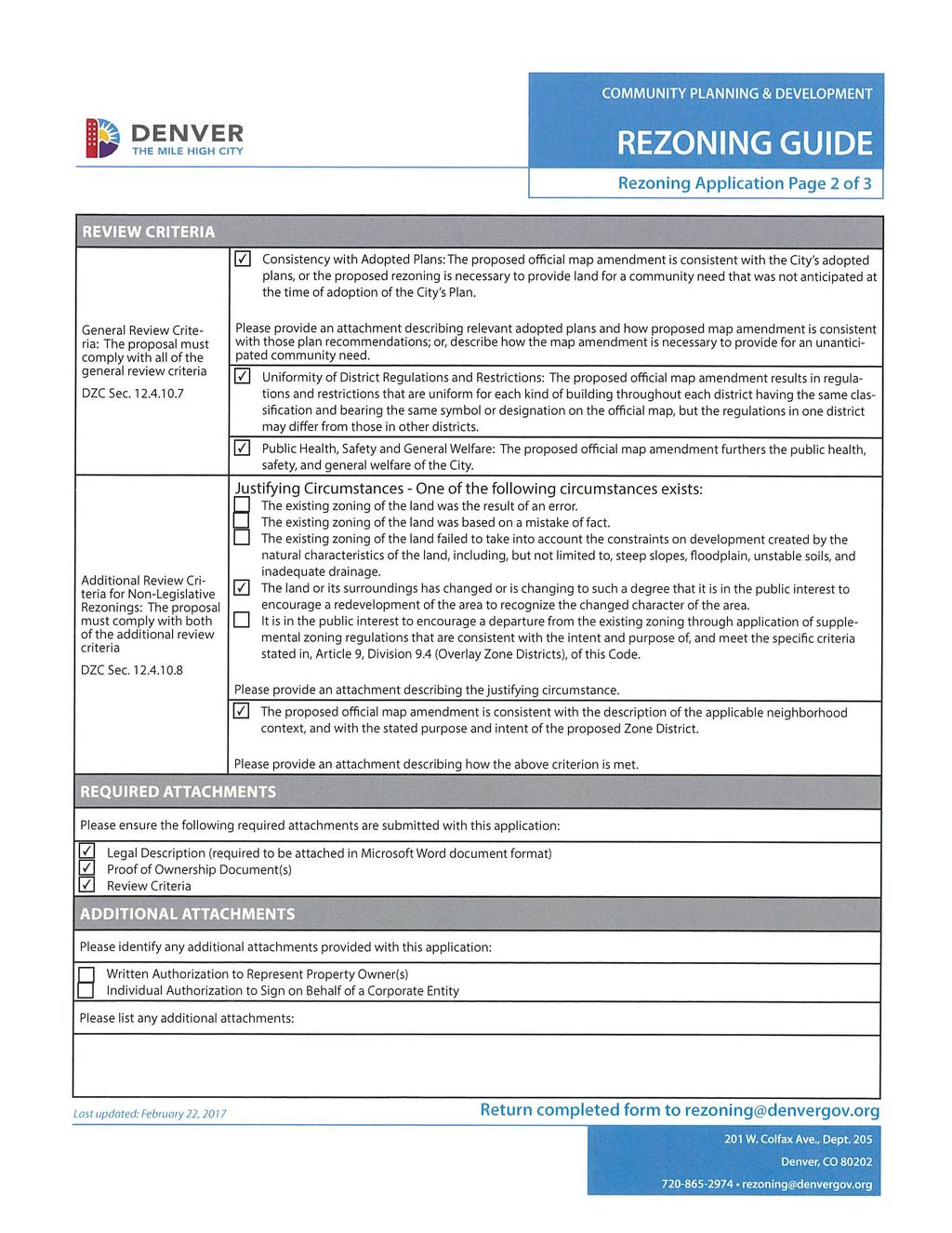
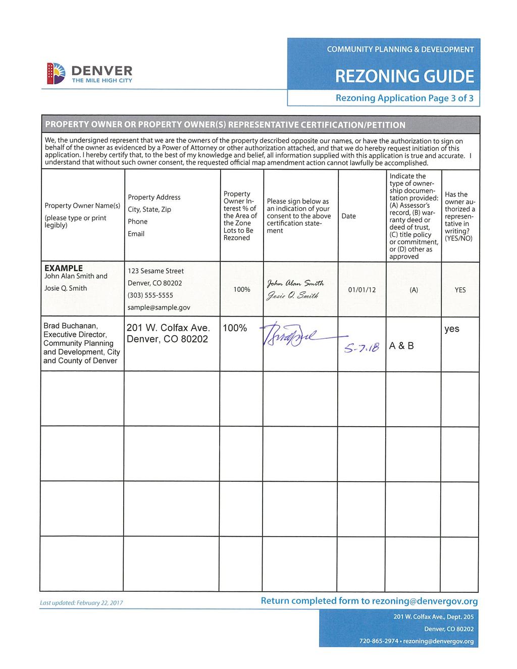
1 Zone Map Amendment (Rezoning) - Application COMMUNITY PLANNING & DEVELOPMENT REZONING GUIDE Rezoning Application Page 1 of 3 PROPERTY OWNER INFORMATION* CHECK IF POINT OF CONTACT FOR APPLICATION Property Owner Name Address City, State, Zip Telephone PROPERTY OWNER(S) REPRESENTATIVE** CHECK IF POINT OF CONTACT FOR APPLICATION Representative Name Address City, State, Zip Telephone *If More Than One Property Owner: All standard zone map amendment applications shall be initiated by all the owners of at least 51% of the total area of the zone lots subject to the rezoning application, or their representatives authorized in writing to do so. See page 3. **Property owner shall provide a written letter authorizing the representative to act on his/her behalf. Please attach Proof of Ownership acceptable to the Manager for each property owner signing the application, such as (a) Assessor s Record, (b) Warranty deed or deed of trust, or (c) Title policy or commitment dated no earlier than 60 days prior to application date. If the owner is a corporate entity, proof of authorization for an individual to sign on behalf of the organization is required. This can include board resolutions authorizing the signer, bylaws, a Statement of Authority, or other legal documents as approved by the City Attorney s Office. SUBJECT PROPERTY INFORMATION Location (address and/or boundary description): Assessor s Parcel Numbers: Area in Acres or Square Feet: Current Zone District(s): PROPOSAL Proposed Zone District: Last updated: February 22, 2017 Return completed form to rezoning@denvergov.org 201 W. Colfax Ave., Dept. 205 Denver, CO rezoning@denvergov.org
2
3
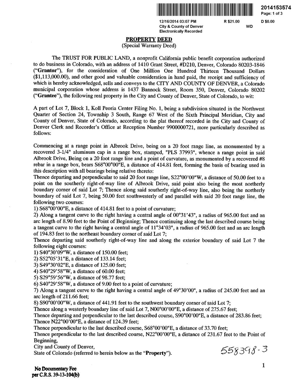
4 LEGAL DESCRIPTION A part of Lot 7, Block 1, Koll Peoria Center Filing No. 1, being a subdivision situated in the Northwest Quarter of Section 24, Township 3 South, Range 67 West of the Sixth Principal Meridian, City and County of Denver, State of Colorado, according to the plat thereof recorded in the City and County of Denver Clerk and Recorder s Office at Reception Number , more particularly described as follows: Commencing at a range point in Albrook Drive, being on a 20 foot range line, as monumented by a recovered 3-1/4" aluminum cap in a range box, stamped, "PLS 37993", whence a range point in said Albrook Drive, Being on a 20 foot range line and a point of curvature, as monumented by a recovered #8 rebar in a range box, bears S "E, a distance of feet, forming the basis of bearing used in this description with all bearings being relative thereto: Thence departing and perpendicular to said 20 foot range line, S "W, a distance of feet to a point on the southerly right-of-way line of Albrook Drive, said point also being the most northerly boundary corner of said Lot 7; Thence along said southerly right-of-way line, also being the northerly boundary of said Lot 7, being feet southwesterly of and parallel with said 20 foot range line, the following two courses: 1) S "E, a distance of feet to a point of curvature; 2) Along a tangent curve to the right having a central angle of ", a radius of feet and an arc length of 8.90 feet to the Point of Beginning; Thence continuing along the last described course being a tangent curve to the right having a central angle of ", a radius of feet and an arc length of feet to the northeast boundary corner of said Lot 7; Thence departing said southerly right-of-way line and along the exterior boundary of said Lot 7 the following eight courses: 1) S "W, a distance of feet; 2) S "E, a distance of feet; 3) S "E, a distance of feet; 4) S "W, a distance of feet; 5) S "W, a distance of feet; 6) S "W, a distance of 9.00 feet to a point of curvature; 7) Along a tangent curve to the right having a central angle of ", a radius of feet and an arc length of feet; 8) S "W, a distance of feet to the southwest boundary corner of said Lot 7; Thence along a westerly boundary line of said Lot 7, N "E, a distance of feet; Thence departing and perpendicular to the last described course, S "E, a distance of feet; Thence N "E, a distance of feet; Thence perpendicular to the last described course, S "E, a distance of feet; Thence perpendicular to the last described course, N "E, a distance of feet to the Point of Beginning, City and County of Denver, State of Colorado.
5
6
7
8 May 7, 2018 Dear CPD Executive Director: I am writing to request the initiation of an official map amendment on the behalf of Parks and Recreation to rezone E. Albrook Drive from S-MX-12 to OS-A district. The property was acquired by the City and County of Denver in 2014 from The Trust for Public Land with the intent for a future open space park and education/community center for and leased by the Environmental Learning for Kids (ELK) nonprofit organization. Construction for this future use is already occurring under the current S-MX-12 zoning. As you know, the Montbello community faces many barriers including high rates of poverty and unemployment, low graduation rates and limited access to support services and open space. This site will provide essential assets for STEM education, environmental health and stewardship, public health, workforce readiness and career opportunities in environmental sciences. Denver Parks and Recreation is partnering with ELK in support of park purposes. Moreover, this partnership project will create space to house ELK s programs and operations, as well as provide a community center and a natural open space that is accessible and free to the public and activated by youth programming furthering DPR s goals as stated in the Game Plan. Please contact Mark Tabor at mark.tabor@denvergov.org if there are any questions or additional clarification is required. He will be your point of contact regarding this request. If he becomes unavailable, at that time I will designate another individual as a point-of-contact for this map amendment request. Sincerely, Allegra Happy Haynes Executive Director, Denver Parks and Recreation CC: Scott Gilmore Gordon Robertson Mark Tabor
9 Map Amendment Application Attachment Review Criteria E. Albrook Drive Review Criteria Analysis 1. Consistency with Adopted Plans The following adopted plans apply to the map amendment request located at E. Albrook Drive: Denver Comprehensive Plan (2000) The Game Plan (2003) Blueprint Denver (2002) Montbello/Green Valley Ranch Neighborhood Plan (1991) Denver Comprehensive Plan (2000) This request is consistent with several Denver Comprehensive Plan strategies. As the subject property is now city owned, OS-A zone district will ensure their continued use for parks, recreation, and related uses. Relevant strategies from the Denver Comprehensive Plan include: Environmental Sustainability Strategy 2-G Preserve and restore, wherever possible, natural habitat for wildlife and plants native to the region (p. 40). Environmental Sustainability Strategy 4-B Respect, conserve and expand wildlife habitat, watersheds, open space and other natural resources (p. 41). Preserve and enhance Denver s livable urban environment through development and maintenance of parks (p. 55). Denver s Legacies Strategy 9-B Integrate sufficient open space and recreational amenities into large-scale development plans (p. 102). Environmental Stewardship Strategy 12-B Continue to encourage residents sense of stewardship for their parks though environmental education and volunteer maintenance programs, with special emphasis on youth (p. 104). Recreation Strategy 13-B Coordinate with DPS and community-based organizations to expand recreation opportunities and after-school programs throughout the city (p. 104). The Game Plan (2003) The Game Plan is the strategic master plan for Denver Parks and Recreation and is an adopted supplement to the Denver Comprehensive Plan. The request to rezone the property to the OS-A district is consistent with The Game Plan s vision, policies and strategies, including: Safe, accessible and flexible open spaces located within ½ mile of every home (p. 32). The Game Plan describes a number of amenities that could be in the city s open spaces, which include passive recreation, learning landscapes, natural open space with opportunities for wildlife. Encourage a variety of public spaces so residents have choices (p. 36). Strengthen partnerships with nonprofits working to increase types and availability of open space (p. 42). Reach more people and create efficiencies through innovative partnerships with other recreation providers (p. 48). page 1
10 Map Amendment Application Attachment Review Criteria E. Albrook Drive Increase Denver Parks and Recreation s ability to provide more programs outside the walls by strengthening existing programs, such as community recreation, outdoor recreation, special needs and service-based learning. Expanding recreation programs to park-based education, cultural and social programs (p. 48). Engage the public, increase stewardship and volunteerism, build partnerships that encourage advocacy and additional financial resources and respond to diverse community needs (p. 104). By rezoning to OS-A, the subject property will have the flexibility to support the nonprofit partnership with Environmental Learning for Kids (ELK), ELK s education and community center as well as the open space use on city owned property and consistently support The Game Plan s vision, policies, recommendations and strategies. Blueprint Denver (2002) According to Blueprint Denver, the subject property has a concept land use of Town Center and is located within an Area of Stability. Future Land Use Blueprint Denver describes Town Centers as similar to neighborhood centers but meet a larger variety of shopping, entertainment, service and employment needs and are large enough to serve several neighborhoods Urban design features such as plazas, landscaping, small parks and civic features contribute to making these places focal points of community activity (pg. 43). The subject property is part of the larger area all designated as a town center. The proposed map amendment supports the Blueprint Denver Town Center concept land use designation by integrating a park with community center activity into the larger town center. Area of Stability The subject property is in an Area of Stability. The goal for Areas of Stability is to identify and maintain the character of an area while accommodating some new development and redevelopment. In some cases, it may be appropriate to change the zoning in an Area of Stability to create a better match between existing land uses and the zoning (pp. 124). The map amendment application is consistent with the Blueprint Denver Area of Stability strategies because it will create a better match between the existing city-owned park and open space land use and the zoning, whereas the current S-MX-12 zoning on the subject property is inconsistent with current conditions relative to ownership. Street Classifications E. Albrook Drive is identified in Blueprint Denver as a Mixed Use Collector street. Collectors are designed to provide a greater balance between mobility and land access within residential, commercial, and industrial areas. The makeup of a collector street largely depends on the density, size and type of nearby buildings. Posted speed limits on collector streets generally range from 25 to 35 miles per hour. (p. 51). E. 46th Avenue is identified in Blueprint Denver as an Undesignated-Local street. Blueprint Denver states the design features of local streets are influenced less by traffic volumes and are tailored more to providing local access. Mobility on local streets is typically incidental and involves relatively short trips at page 2
11 Map Amendment Application Attachment Review Criteria E. Albrook Drive lower speeds to and from other streets (p. 51). The educational and community center and open space park allowed by OS-A can be suitable along such streets, so the proposed rezoning is consistent with the Blueprint Denver street classification. Moreover, the education and community center as well as the park is already under construction under the S-MX-12 zone district. The proposed map amendment to OS-A will not result in any additional impacts over and above what is already allowed by to any adjacent streets. Montbello/Green Valley Ranch Neighborhood Plan (1991) In 1991 Denver City Council adopted the Montbello/Green Valley Ranch Neighborhood Plan which still applies to the subject property. The plan provides limited guidance for the requested map amendment, but does contain policies supporting community services, parks and open space. The future land use map encourages rezoning the area to B-4. Recommendation LZM-1 states, prohibit vehicle sales, adult businesses. Billboards and uses inappropriate at this major entry point to the residential neighborhood. Encourage neighborhood serving retail shops and attractive landscaping along Albrook Drive street frontage (p. 8). The Montbello/Green Valley Ranch Neighborhood Plan does not specifically preclude park uses as part of a vibrant commercial area and rezoning to OS-A will ensure attractive landscaping along Albrook Drive. The rezoning to OS-A is not inconsistent with this plan. 2. Uniformity of District Regulations and Restrictions The proposed rezoning to OS-A will result in the uniform application of zone district building form, use, and design regulations and make the subject property consistent with the purpose of the OS-A zone district. 3. Public Health, Safety and General Welfare The proposed official map amendment furthers the public health, safety, and general welfare of the City by furthering adopted plans and making the subject properties consistent with the purpose of the OS-A zone district. OS-A zoning on the subject property will provide flexibility and better enable maintenance and enhancements for of the open space park and associated uses than the S-MX-12 zone district does with the transfer of ownership to the City. 4. Justifying Circumstances The rezoning is justified under DZC Section A.4, The land or its surrounding environs has changed or is changing to such a degree that it is in the public interest to encourage a redevelopment of the area or to recognize the changed character of the area. The changed condition is that in December 2014, the City acquired the subject property from The Trust for Public Land and construction for the open space park and education/community center is underway The OS-A zone district requested is explicitly intended for open space and parks owned, operated, or leased by the City and managed by the City s Department of Parks and Recreation. page 3
12 Map Amendment Application Attachment Review Criteria E. Albrook Drive 5. Consistency with Neighborhood Context Description, Zone District Purpose and Intent Statements The requested zone district is within the Open Space Context, which consists of all forms of public and private parks and open spaces. The context accommodates sites ranging from very active to completely passive, and from those embedded in a neighborhood to sites that are large enough to stand alone. Active sites may include high use areas such as athletic fields, while passive areas focus on resource protection, trails, walking. Within this context, the OS-A zone district is intended to protect and preserve public parks owned, operated or leased by the City and managed by the City s Department of Parks and Recreation for park purposes (DZC 9.3.1, 9.3.2). The requested rezoning is consistent with the neighborhood context description and zone district purpose and intent because the requested zoning will make the property consistent with existing city ownership of, and current plans underway for, the subject property which will include continued operation for various parks and open space uses for park purposes. page 4
REZONING GUIDE. Zone Map Amendment (Rezoning) - Application. Rezoning Application Page 1 of 3. Return completed form to
 - Application. Rezoning Application Page 1 of 3. Return completed form to") Zone Map Amendment (Rezoning) - Application COMMUNITY PLANNING & DEVELOPMENT REZONING GUIDE Rezoning Application Page 1 of 3 PROPERTY OWNER INFORMATION* CHECK IF POINT OF CONTACT FOR APPLICATION Property
Zone Map Amendment (Rezoning) - Application COMMUNITY PLANNING & DEVELOPMENT REZONING GUIDE Rezoning Application Page 1 of 3 PROPERTY OWNER INFORMATION* CHECK IF POINT OF CONTACT FOR APPLICATION Property
Staff Report and Recommendation
 Community Planning and Development Planning Services 201 W. Colfax Ave., Dept. 205 Denver, CO 80202 p: 720.865.2915 f: 720.865.3052 www.denvergov.org/cpd TO: City Council Neighborhoods and Planning Committee
September 25th, 2018 $2000 fee pd CC
 2.7267 acres 2018I-00075 September 25th, 2018 $2000 fee pd CC Rezoning Review Criteria Analysis - Map Amendment Application Number: 2018I-00075 805 W. 38 th Avenue October 19, 2018 (amd.) September 17,
Planning Services Community Planning and Development 201 W. Colfax Ave., Dept. 205 Denver, CO p
 TO: Denver Planning Board, Julie Underdahl, Chair FROM: Theresa Lucero, Senior City Planner DATE: RE: Official Zoning Map Amendment Application #2017I-00042 Staff Report and Recommendation Based on the
Official Zoning Map Amendment Application #2018I-00077
 Community Planning and Development Planning Services 201 W. Colfax Ave., Dept. 205 Denver, CO 80202 p: 720.865.2915 f: 720.865.3052 www.denvergov.org/cpd TO: Denver Planning Board FROM: Scott Robinson,
, C-MS I June 3, 2016 $1500 pd chk #216918
 , C-MS-8 LOTS 21 THROUGH 40, INCLUSIVE, BLOCK 299 CLEMENTS ADDITION TO THE CITY OF DENVER SOUTHEAST QUARTER OF SECTION 34, TOWNSHIP 3 SOUTH, RANGE 68 WEST, SIXTH PRINCIPAL MERIDIAN, CITY
Denver Land Use, Transportation and Infrastructure Committee FROM: Andrew Webb, Senior City Planner DATE: March 22, 2018 RE:
 Community Planning and Development Planning Services 201 W. Colfax Ave., Dept. 205 Denver, CO 80202 p: 720.865.2915 f: 720.865.3052 www.denvergov.org/cpd TO: Denver Land Use, Transportation and Infrastructure
Staff Report and Recommendation Based on the criteria for review in the Denver Zoning Code, Staff recommends approval for Application #2018I
 Community Planning and Development Planning Services 201 W. Colfax Ave., Dept. 205 Denver, CO 80202 p: 720.865.2915 f: 720.865.3052 www.denvergov.org/cpd TO: Denver Planning Board FROM: Sara White, AICP,
2 nd & St Paul, LLC and BAH-PLA, LLC
 Community Planning and Development Planning Services 201 W. Colfax Ave., Dept. 205 Denver, CO 80202 p: 720.865.2915 f: 720.865.3052 www.denvergov.org/cpd TO: Denver City Council FROM: Theresa Lucero, Senior
Official Zoning Map Amendment Application #2018I-00047
 Community Planning and Development Planning Services 201 W. Colfax Ave., Dept. 205 Denver, CO 80202 p: 720.865.2915 f: 720.865.3052 www.denvergov.org/cpd TO: Denver Planning Board FROM: Chandler Van Schaack,
EAST LAKE TARPON COMMUNITY OVERLAY
 EAST LAKE TARPON COMMUNITY OVERLAY East Lake Tarpon in Pinellas County Florida physical area is defined by the boundaries of the as shown in the map below and legal description in Appendix A. VISION: East
RESOLUTION NO. WHEREAS, the City of Riverdale (the City ) has a planning commission and has adopted a general plan pursuant to applicable law; and
 has a planning commission and has adopted a general plan pursuant to applicable law; and") RESOLUTION NO. RESOLUTION OF THE REDEVELOPMENT AGENCY OF RIVERDALE CITY ADOPTING AN OFFICIAL PROJECT AREA PLAN FOR THE 700 WEST COMMUNITY DEVELOPMENT PROJECT AREA. WHEREAS, the Redevelopment Agency of
RESOLUTION NO. RESOLUTION OF THE REDEVELOPMENT AGENCY OF RIVERDALE CITY ADOPTING AN OFFICIAL PROJECT AREA PLAN FOR THE 700 WEST COMMUNITY DEVELOPMENT PROJECT AREA. WHEREAS, the Redevelopment Agency of
CITY PLANNING COMMISSION AGENDA ITEMS: C.1, C.2 STAFF: MEGGAN HERINGTON FILE NO(S): CPC PUZ QUASI-JUDICIAL CPC PUD QUASI-JUDICIAL
: CPC PUZ QUASI-JUDICIAL CPC PUD QUASI-JUDICIAL") Page 32 CITY PLANNING COMMISSION AGENDA ITEMS: C.1, C.2 STAFF: MEGGAN HERINGTON FILE NO(S): CPC PUZ 13-00036 QUASI-JUDICIAL CPC PUD 13-00037 QUASI-JUDICIAL PROJECT: APPLICANT: OWNER: ESTANCIA AT CORDERA
Page 32 CITY PLANNING COMMISSION AGENDA ITEMS: C.1, C.2 STAFF: MEGGAN HERINGTON FILE NO(S): CPC PUZ 13-00036 QUASI-JUDICIAL CPC PUD 13-00037 QUASI-JUDICIAL PROJECT: APPLICANT: OWNER: ESTANCIA AT CORDERA
Staff Report and Recommendation Based on the criteria for review in the Denver Zoning Code, Staff recommends approval for Application #2017I
 TO: Denver City Council Land Use, Transportation and Infrastructure Committee FROM: Theresa Lucero, Senior City Planner DATE: RE: Official Zoning Map Amendment Application #2017I-00149 Staff Report and
CITY COUNCIL STAFF REPORT
 COUNCIL AGENDA: 04/11/17 ITEM: W\0^ CITY OF e: :SS SAN JOSE CAPITAL OF SILICON VALLEY CITY COUNCIL STAFF REPORT File No. C16-030 Applicant: Alex Rubashevsky Location Northwest corner of Oakland Road and
CHAPTER 12 IMPLEMENTATION
 CHAPTER 12 IMPLEMENTATION The 2010 Town of Denton Comprehensive Plan is intended to capture a vision of the future of Denton. As such, it provides a basis for a wide variety of public and private actions
Official Zoning Map Amendment Application #2018I-00075
 Community Planning and Development Planning Services 201 W. Colfax Ave., Dept. 205 Denver, CO 80202 p: 720.865.2915 f: 720.865.3052 www.denvergov.org/cpd TO: Denver Planning Board FROM: Scott Robinson,
TO: Denver Planning Board FROM: Chandler Van Schaack, Senior City Planner DATE: March 27, 2019 RE:
 Community Planning and Development Planning Services W. Colfax Ave., Dept. Denver, CO 0 p:.. f:..0 www.denvergov.org/cpd TO: Denver Planning Board FROM: Chandler Van Schaack, Senior City Planner DATE:
Staff Report and Recommendation
 Community Planning and Development Planning Services 201 W. Colfax Ave., Dept. 205 Denver, CO 80202 p: 720.865.2915 f: 720.865.3052 www.denvergov.org/cpd TO: Denver City Council FROM: Steve Nalley, Neighborhood
CITY CLERK. Parkland Acquisition Strategic Directions Report (All Wards)
") CITY CLERK Clause embodied in Report No. 10 of the, as adopted by the Council of the City of Toronto at its meeting held on November 6, 7 and 8, 2001. 10 Parkland Acquisition Strategic Directions Report
CITY CLERK Clause embodied in Report No. 10 of the, as adopted by the Council of the City of Toronto at its meeting held on November 6, 7 and 8, 2001. 10 Parkland Acquisition Strategic Directions Report
THENCE NORTH 20 31'13" EAST, A DISTANCE OF 1, FEET ALONG SAID WEST LINE TO THE NORTH LINE OF SAID TRACT A;
 PEORIA ST BRONCOS PARKWAY CENTENNIAL AIRPORT ARAPAHOE COUNTY DOUGLAS COUNTY NORTH DOUGLAS COUNTY INDUSTRIAL PARK AIRPORT 0 E-0 PARK DOVE VALLEY HIGHFIELD BUSINESS CHAMBERS ROAD DOVE VALLEY M.U. PUD JORDAN
Staff Report to the North Ogden City Planning Commission
 Staff Report to the North Ogden City Planning Commission SYNOPSIS / APPLICATION INFORMATION Application Request: Concept review on a legislative application to rezone land located at approximately 1750
Planning and Growth Management Committee. Chief Planner and Executive Director, City Planning Division. Pg12013 (File No NNY 34 OZ)
") 865 York Mills Road Official Plan Amendment Application Preliminary Report STAFF REPORT ACTION REQUIRED Date: February 28, 2012 To: From: Wards: Reference Number: Planning and Growth Management Committee
865 York Mills Road Official Plan Amendment Application Preliminary Report STAFF REPORT ACTION REQUIRED Date: February 28, 2012 To: From: Wards: Reference Number: Planning and Growth Management Committee
TO: Denver Planning Board FROM: Analiese Hock, Senior City Planner DATE: March 13, 2018 RE:
 Community Planning and Development Planning Services 201 W. Colfax Ave., Dept. 205 Denver, CO 80202 p: 720.865.2915 f: 720.865.3052 www.denvergov.org/cpd TO: Denver Planning Board FROM: Analiese Hock,
To: S-MX-8 AIO, S-MX-8A AIO, S-MX-12 AIO, C-MX-8 AIO, C-MX-12 AIO, and S-CC-5 AIO
 Community Planning and Development Planning Services 201 W. Colfax Ave., Dept. 205 Denver, CO 80202 p: 720.865.2915 f: 720.865.3052 www.denvergov.org/cpd TO: City Council Neighborhoods and Planning Committee
A Growing Community Rural Settlement Areas
 Town of Huntsville Official Plan Review - POLICY BACKGROUND PAPER A Growing Community Rural Settlement Areas BACKGROUND: In addition to the fully municipally-serviced Urban Settlement Area and the Hidden
Planning Division Transmittal
 Planning Division Transmittal File Number: CAR18-00021 Hearing Date: 10/8/18 X-Ref: Hearing Body: Planning and Zoning Commission Address: 200 W MYRTLE STREET Transmittal Date: 8/31/18 Applicant: RIVER
ORDINANCE NO
 ATTACHMENT CC-1 ORDINANCE NO. 13-2113 AN ORDINANCE OF THE CUPERTINO CITY COUNCIL APPROVING THE REZONING OF AN APPROXIMATELY 1.1 ACRE AREA FROM PARK AND RECREATION (PR) TO PLANNED INDUSTRIAL PARK (P(MP))
GDP BOUNDARY Christopher A. Brooks, PLS for and on behalf of Matrix Design Group, Inc. VICINITY MAP SCALE: N.T.S.
 COVER SHEET I, Christopher A. Brooks, a Registered Land Surveyor in the State of Colorado, do hereby certify that the description as shown on Sheet 2, for the Buckley Annex General Development Plan was
17.11 Establishment of Land Use Districts
 17.11 Establishment of Land Use Districts 17.11.010 Purpose. To promote the health, safety, and general welfare of City residents and those who come to South Salt Lake to work, exchange commerce and recreate.
EXECUTIVE SUMMARY DRAFT CHAPTER 1 INTRODUCTION EXECUTIVE SUMMARY
 CHAPTER 1 EXECUTIVE SUMMARY INTRODUCTION Through the joint efforts of the City of Tulsa planning staff and the Land Services division of Indian Nations Council of Governments (INCOG), the Berryhill Land
DENVER DESIGN DISTRICT GDP
 DENVER DESIGN DISTRICT GDP Urban Design Standards and Guidelines November 17, 2008 Amended February 3, 2016 City and County of Denver CF Property Management, Inc. C/O Denver Design District - Starboard
Parks, Open Space and Trails
 Introduction Parks have often been referred as the lungs of our cities, cleansing the air of pollutants and particulate matter. Parks are also gathering places for families and community. They offer spaces
Planning Commission April 4, 2013 BOCC Workshop Page 1
 Planning Commission April 4, 2013 BOCC Workshop Page 1 Planning Commission April 4, 2013 BOCC Workshop Page 2 Planning Commission April 4, 2013 BOCC Workshop Page 3 Planning Commission April 4, 2013 BOCC
TOWN OF INNISFIL SPECIAL COUNCIL AGENDA OUR JOBS INNISFIL HEIGHTS WORKSHOP WEDNESDAY JANUARY 20, :30 P.M.
 January 13, 2016 TOWN OF INNISFIL SPECIAL COUNCIL AGENDA INNISFIL HEIGHTS WORKSHOP WEDNESDAY JANUARY 20, 2016 5:30 P.M. PLEASE REMEMBER TO TURN OFF CELL PHONES 1. OPENING OF MEETING BY THE MAYOR Opening
TO: Staff Report and Recommendation
 Community Planning and Development Planning Services 201 W. Colfax Ave., Dept. 205 Denver, CO 80202 p: 720.865.2915 f: 720.865.3052 www.denvergov.org/cpd TO: City Council Neighborhoods and Planning Committee
District 9, Albus Brooks Blueprint Denver: Area of Change City and County of Denver, National Western Center
 To: Landmark Preservation Commission From: Kara Hahn, Principal Planner, Community Planning & Development (CPD) Date: December 10, 2018 RE: Landmark Designation for the Armour & Company Administration
BILL NO ORDINANCE NO. 5238
 BILL NO. 5383 ORDINANCE NO. 5238 AN ORDINANCE VACATING VARIOUS STREET PROPERTIES OF THE CITY OF RICHMOND HEIGHTS, MISSOURI, ST. LOUIS COUNTY; DESCRIBED GENERALLY AS PART OF ABERDEEN AVENUE (AKA AS STOCKARD
Planning & Zoning Commission Staff Report
 Planning & Zoning Commission Staff Report Meeting Date: May 26, 2015 Drafted by: Katherine Harrison-Rogers CASE # Z2886 PROJECT NAME: APPLICANT/ REPRESENTATIVE: Shawna Runyan PROPERTY OWNER: 1840 (previously
2018 Northampton Township Comprehensive Plan
 2018 BUCKS COUNTY, PENNSYLVANIA What is a? A comprehensive plan is a municipality s main policy document that details the collective vision for the future, the historic, environmental, and cultural facilities
Land Use Amendment in Southwood (Ward 11) at and Elbow Drive SW, LOC
 at and Elbow Drive SW, LOC") 2018 November 15 Page 1 of 10 EXECUTIVE SUMMARY This land use amendment application was submitted by Rick Balbi Architect on 2017 August 31 on behalf of Sable Developments Ltd, and with authorization from
2018 November 15 Page 1 of 10 EXECUTIVE SUMMARY This land use amendment application was submitted by Rick Balbi Architect on 2017 August 31 on behalf of Sable Developments Ltd, and with authorization from
POCKET COMMUNITY PLAN
 POCKET COMMUNITY PLAN Part Three : COMMUNITY PLAN AREAS AND SPECIAL STUDY AREAS CONTENTS Community Location... 3-P-3 Community Vision... 3-P-4 Community Profile... 3-P-4 Community Issues... 3-P-6 Land
Steering Committee Meeting
 Neighborhood Planning Initiative NPI EAST CENTRAL AREA PLAN Steering Committee Meeting November 9, 2017 6:00PM 8:00PM Tears McFarlane House East Central Area Plan Steering Committee Meeting 11/9/17 AGENDA
CITY OF COLWICH COMPREHENSIVE PLAN LAND USE LAND USE 1
 LAND USE LAND USE 1 WHAT YOU WILL FIND IN THIS CHAPTER: Discussion of today s conditions and tomorrow s projections Discussion of challenges and opportunities Discussion of the environmental quality goals,
STAFF REPORT TO THE CITY COUNCIL. Conduct Public Hearing to vacate certain public right of way adjacent to Sycamore Avenue and San Pablo Avenue
 STAFF REPORT TO THE CITY COUNCIL DATE: Adjourned Regular Meeting of December 16, 2014 TO: SUBMITTED BY: SUBJECT: Mayor and Members of the City Council Holly Smyth, Planning Director Conduct Public Hearing
SECTION UNIFIED DEVELOPMENT ORDINANCE SECTION Part 1 Ordinance. ARTICLE 1 Zoning Districts
 SECTION 1-100 UNIFIED DEVELOPMENT ORDINANCE SECTION 1-300 Part 1 Ordinance SECTION 1-100. Introduction. ARTICLE 1 Zoning Districts Crystal Lake strives to maintain a balance of various land uses for a
Metro Center. Urban Renewal Project
 Restated Urban Renewal Plan for the Metro Center Urban Renewal Project Des Moines, Ia. [Up to and including the 12 th Amendment] Approved by City Council Resolution No. 13-- on. 2013 Metro Center Urban
West Ocala Vision & Community Plan City Council Work Session. Presented by West Ocala Community Plan Steering Committee
 West Ocala Vision & Community Plan City Council Work Session Presented by West Ocala Community Plan Steering Committee November 29,2011 Ocala 2035 Vision West Ocala Community Vision & Master Plan West
AWH REPORT OF THE PLANNING AND DEVELOPMENT DEPARTMENT FOR APPLICATION FOR REZONING ORDINANCE TO PLANNED UNIT DEVELOPMENT
 AWH REPORT OF THE PLANNING AND DEVELOPMENT DEPARTMENT FOR APPLICATION FOR REZONING ORDINANCE TO PLANNED UNIT DEVELOPMENT MAY 8, 2014 The Planning and Development Department hereby forwards to the Planning
SAN RAFAEL CITY COUNCIL AGENDA REPORT
 Agenda Item No: 7.b Meeting Date: December 4, 2017 SAN RAFAEL CITY COUNCIL AGENDA REPORT Department: Public Works/City Attorney Prepared by: Kevin McGowan, Asst. Director of Public Works Lisa Goldfien,
SPECIFIC PLAN Requirements
 CITY OF LANCASTER PLANNING DEPARTMENT 44933 Fern Avenue, Lancaster, California 93534 (661) 723-6100 SPECIFIC PLAN Requirements Purpose The purpose of a specific plan is to provide for the logical development
ROAD CLOSURE AND LAND USE AMENDMENT SILVER SPRINGS (WARD 1) NORTHEAST OF NOSEHILL DRIVE NW AND SILVER SPRINGS ROAD NW BYLAWS 2C2018 AND 29D2018
 NORTHEAST OF NOSEHILL DRIVE NW AND SILVER SPRINGS ROAD NW BYLAWS 2C2018 AND 29D2018") Page 1 of 19 EXECUTIVE SUMMARY This application proposes redesignating two parcels in the community of Silver Springs from Special Purpose Future Urban Development (S-FUD) District and undesignated road
Page 1 of 19 EXECUTIVE SUMMARY This application proposes redesignating two parcels in the community of Silver Springs from Special Purpose Future Urban Development (S-FUD) District and undesignated road
S A C R A M E N T O C O U N T Y JACKSON HIGHWAY & GRANT LINE EAST VISIONING STUDY
 JACKSON HIGHWAY & GRANT LINE EAST S A C R A M E N T O C O U N T Y P L A N N I N G D E P A R T M E N T SUMMARY AND WORKBOOK November 19, 2008 History of the Visioning Study Sacramento County has two growth
ARTICLE 6: Special and Planned Development Districts
 ARTICLE 6: Special and Planned Development Districts 6-10 Traditional Neighborhood Development (TND) District 6-10.10 Purpose and Intent The Traditional Neighborhood Development (TND) District provides
Planned Residential Neighborhoods Land Use Goals
 Planned Residential Neighborhoods Land Use Goals Issue: Guidelines that provide for diverse high quality residential areas that include a variety of housing styles and layouts are needed. Goal 1: Create
Staff Report and Recommendation
 Community Planning and Development Planning Services 201 W Colfax Ave, Dept 205 Denver, CO 80202 p: 720-865-2972 f: 720-865-3056 www.denvergov.org/planning TO: LUTI FROM: Steve Nalley, Senior City Planner
Applicant Name Phone / Fax / Address City State Zip Code . Property Owner Phone / Fax / Address City State Zip Code
 Master Development Plan Application Community Development Department City of Redmond 411 SW 9 th Street Redmond, Oregon 97756 541-923-7721 541-548-0706 FAX Master Development Plan Fee $38,862.52 File Number
CHAPTER 1. Ms. Guajardo s Class - Central Elementary CH 1 1
 INTRODUCTION CHAPTER 1 Ms. Guajardo s Class - Central Elementary CH 1 1 1.1 SETTING South Centre City is a linear corridor south of Downtown Escondido paralleling Centre City Parkway and South Escondido
CHAPTER 7: VISION AND ACTION STATEMENTS. Noble 2025 Vision Statement
 CHAPTER 7: VISION AND ACTION STATEMENTS This chapter presents the vision, policy and action statements that transform the comprehensive planning study, an analysis of Noble s past, future trends and community
Overview of the Plan. The Building Blocks of Centers, Neighborhoods and Network INTERNAL DRAFT
 Overview of the Plan 4 East Davidson Ramah Church Rd June Washam Rd Bradford District Park Bradford Shearer Rd Campus District NC 73 Davidson-Concord North Rocky River This Master Plan projects an approximate
that the Town Board of the Town of East Greenbush will hold a public hearing on April 11,
 TOWN OF EAST GREENBUSH NOTICE OF PUBLIC HEARING PLEASE TAKE NOTICE that the Town Board of the Town of East Greenbush will hold a public hearing on April 11, 2018, at 5:45 p.m. at the East Greenbush Town
3. VISION AND GOALS. Vision Statement. Goals, Objectives and Policies
 Vision Statement Queen Creek s interconnected network of parks, trails, open spaces and recreation opportunities provide safe and diverse activities and programs that sustain its unique, small town, equestrian
Committee of the Whole (Public Hearing) Report
 Report") Item:1 Committee of the Whole (Public Hearing) Report DATE: Tuesday, June 05, 2018 WARD: 2 TITLE: OFFICIAL PLAN AMENDMENT FILE OP.17.016 ZONING BY-LAW AMENDMENT FILE Z.17.046 IMPORTANNE MARKETING INC.
Item:1 Committee of the Whole (Public Hearing) Report DATE: Tuesday, June 05, 2018 WARD: 2 TITLE: OFFICIAL PLAN AMENDMENT FILE OP.17.016 ZONING BY-LAW AMENDMENT FILE Z.17.046 IMPORTANNE MARKETING INC.
PARKS AND RECREATION
 PARKS AND RECREATION WHAT YOU WILL FIND IN THIS CHAPTER: Background information on the development of the Park, Recreation, and System Plan (PRSP). General overview of Ellensburg s parks and recreation
RECREATION AND OPEN SPACE ELEMENT GOALS, OBJECTIVES, AND POLICIES
 RECREATION AND OPEN SPACE ELEMENT GOALS, OBJECTIVES, AND POLICIES Goal 7 To provide park facilities, recreation programs, and open space resources that are safe, adequate, and accessible to all City residents,
ORDINANCE WHEREAS, this Ordinance is consistent with the City of Winter Garden Comprehensive Plan; and
 ORDINANCE 17-06 AN ORDINANCE OF THE CITY COMMISSION OF THE CITY OF WINTER GARDEN, FLORIDA, CREATING ARTICLE XIV OF CHAPTER 118 OF THE CITY OF WINTER GARDEN CODE OF ORDINANCES PROVIDING FOR THE EAST PLANT
NEC of Central Avenue and Indian School Road
 NEC of Central Avenue and Indian School Road For this location, there are two applicable plans that provide guidance on development. The two plans include the Indian School Specific Plan (1991) and the
#2017I E-RH-2.5 Highland Ventures Holdings, LLC and Irving Estates, LLC
 TO: Denver Planning Board - Joel Noble, Chair FROM: Theresa Lucero, Senior City Planner DATE: RE: Official Zoning Map Amendment Application #2017I-00178 1080 and 1090 King Street Rezoning from E-SU-D1x
Town of Castle Rock DRCOG 2013 Annual Growth and Development Report. Introduction. Section 1 Metro Vision 2035
 Town of Castle Rock DRCOG 2013 Annual Growth and Development Report Introduction This is the Town of Castle Rock s sixth annual report to the Denver Regional Council of Governments (DRCOG) reporting on
Arlington, Virginia is a worldclass
 EXECUTIVE S U M M A RY Arlington maintains a rich variety of stable neighborhoods, quality schools and enlightened land use policies, and received the Environmental Protection Agency s highest award for
Edward R. Sajecki Commissioner of Planning and Building. SUBJECT: Draft Lakeview Local Area Plan (January 2014)
") Corporate Report Clerk s Files Originator s Files CD.03.LAK DATE: TO: FROM: Chair and Members of Planning and Development Committee Meeting Date: February 3, 2014 Edward R. Sajecki Commissioner of Planning
Corporate Report Clerk s Files Originator s Files CD.03.LAK DATE: TO: FROM: Chair and Members of Planning and Development Committee Meeting Date: February 3, 2014 Edward R. Sajecki Commissioner of Planning
Support the implementation of Cape Coral's Comprehensive Plan. Protect and utilize the unique natural resources in the City.
 7.0 OVERVIEW - RECOMMENDATIONS Chapter 7 The preparation of the Cape Coral Parks and Recreation Master Plan spanned a period of approximately 12 months. Plan preparation included the input of a wide range
YONGE STEELES CORRIDOR SECONDARY PLAN. Young + Wright / IBI Group Architects Dillon Consulting Ltd. GHK International (Canada) Ltd.
 Ltd.") PART A: PREAMBLE 1.0 PURPOSE The purpose of this Secondary Plan is to provide a development framework for intensification of the Yonge/ Steeles corridor including the north side of Steeles Avenue West
PART A: PREAMBLE 1.0 PURPOSE The purpose of this Secondary Plan is to provide a development framework for intensification of the Yonge/ Steeles corridor including the north side of Steeles Avenue West
Regional Context Statement
 Regional Context Statement REGIONAL CONTEXT STATEMENT 3. REGIONAL CONTEXT STATEMENT In 1995, the Provincial Government passed into law the Growth Strategies Act. The purpose of this provincial initiative
Central Platte Valley Auraria District Amendment. Steering Committee Meeting #
 Central Platte Valley Auraria Amendment Steering Committee Meeting #1 4.26.2017 Central Platte Valley Auraria Amendment Welcome of Steering Committee Members Co-Chairs: Tami Door & Bar Chadwick Brief Introductions
General Manager, Planning and Development; General Manager, Parks, Recreation and Culture. Proposed Mini-Park and Plaza Designations
 Corporate NO: R106 Report COUNCIL DATE: June 16, 2008 REGULAR COUNCIL TO: Mayor & Council DATE: June 12, 2008 FROM: SUBJECT: General Manager, Planning and Development; General Manager, Parks, Recreation
CITY OF ANN ARBOR MASTER PLAN. Land Use Element
 CTY OF ANN ARBOR MASTER PLAN Land Use Element June 15, 2009 Prepared by the Ann Arbor City Planning and Development Services Unit and the City of Ann Arbor Planning Commission City Master Plan: Land Use
9 CITY OF VAUGHAN OFFICIAL PLAN AMENDMENT NO BOCA EAST INVESTMENTS LIMITED
 9 CITY OF VAUGHAN OFFICIAL PLAN AMENDMENT NO. 631 - BOCA EAST INVESTMENTS LIMITED The Planning and Economic Development Committee recommends the adoption of the recommendations contained in the following
City of Tacoma Planning and Development Services
 Agenda Item D-1 City of Tacoma Planning and Development Services To: Planning Commission From: Elliott Barnett, Planning Services Division Subject: Application #2014-08 Open Space Element Update Meeting
The Corporation of the TOWN OF MILTON
 Report to: From: Chair & Members of the Administration & Planning Standing Committee W.F. Mann, Director of Planning and Development Date: April 16, 2012 PD 022-12 (Z19/11) Subject: Technical Report Proposed
WHEREAS, the current Comprehensive Plan was adopted in 2005; and
 RESOLUTION 2018-06 RESOLUTION TO AMEND THE CITY S COMPREHENSIVE PLAN TO (1) AMEND CHAPTER 4 TO ADD A SPECIAL REVITALIZATION DISTRICT FOR EDUCATION AND ECONOMIC DEVELOPMENT ; (2) DESIGNATE ON THE FUTURE
This page intentionally blank.
 This page intentionally blank. Parks, Recreation, and Open Space Chapter Relationship to Vision Vision Parks, Recreation and Open Space Chapter Concepts County Government. County government that is accountable
1) Providing education, access to healthy foods, and economic support for the local food system
 Providing education, access to healthy foods, and economic support for the local food system") Page 1 of x s Policy Statement Community gardens should be created, where appropriate, within designated urban agriculture areas in neighborhood parks, as well as on tax-forfeited parcels that are acquired
Page 1 of x s Policy Statement Community gardens should be created, where appropriate, within designated urban agriculture areas in neighborhood parks, as well as on tax-forfeited parcels that are acquired
TREASURE COAST REGIONAL PLANNING COUNCIL M E M O R A N D U M. To: Council Members AGENDA ITEM 3I
 TREASURE COAST REGIONAL PLANNING COUNCIL M E M O R A N D U M To: Council Members AGENDA ITEM 3I From: Date: Subject: Staff December 8, 2017 Council Meeting Local Government Comprehensive Plan Review Draft
CITY OF PUYALLUP. Background. Development Services
 CITY OF PUYALLUP Development Services 333 South Meridian Puyallup WA 98371 To: City Council From: Katie Baker, AICP, Planning Division Re: South Hill Neighborhood Plan Adoption Date: (Meeting date: February
PLAN ELEMENTS WORKSHOP. April 5, 2016
 PLAN ELEMENTS WORKSHOP April 5, 2016 needs more housing. But there is no one-size fits-all solution. Every neighborhood has its own character. In some places, density is not only appropriate it is badly
DRAFT FOR PUBLIC REVIEW. Game Plan for a Healthy City
 DRAFT FOR PUBLIC REVIEW 2018 Game Plan for a Healthy City 2 Denveright. Parks & Recreation Game Plan Draft for Public Review Draft for Public Review Executive Summary Game Plan Overview Executive Summary
A. WHAT IS A GENERAL PLAN?
 I. Introduction A. WHAT IS A GENERAL PLAN? A general plan is the planning guideline for the future of a city. It contains goals and policies which regulate urban development, the protection of the natural
REGIONAL ACTIVITY CENTER
 DRAFT REGIONAL ACTIVITY CENTER 70 EAST BENCH MASTER PLAN DRAFT 06 Introduction The East Bench Regional Activity center is comprised of large educational, research, medical, and employment centers. These
LAND USE AMENDMENT DOWNTOWN COMMERCIAL CORE (WARD 7) MACLEOD TRAIL SE AND 5 AVENUE SE BYLAW 254D2017
 MACLEOD TRAIL SE AND 5 AVENUE SE BYLAW 254D2017") Page 1 of 10 EXECUTIVE SUMMARY This Land Use Amendment application seeks to redesignate a full downtown block (currently the YWCA site) from a Direct Control based on the CM-2 District (Land Use Bylaw
Page 1 of 10 EXECUTIVE SUMMARY This Land Use Amendment application seeks to redesignate a full downtown block (currently the YWCA site) from a Direct Control based on the CM-2 District (Land Use Bylaw
CONSENT CALENDAR CITY PLANNING COMMISSION AGENDA ITEM NO: A.1, A.2 STAFF: LARRY LARSEN
 Page 8 CONSENT CALENDAR CITY PLANNING COMMISSION AGENDA ITEM NO: A.1, A.2 STAFF: LARRY LARSEN FILE NO: CPC PUZ 14-00013 - QUASI-JUDICIAL FILE NO: CPC PUD 14-00014 QUASI-JUDICIAL PROJECT: APPLICANT: OWNER:
Welcome! Far Northeast Area Plan Meeting #3 Council District 11 Town Hall Meeting Resource Fair. Jan. 30, 2018
 Welcome! Far Northeast Area Plan Meeting #3 Council District 11 Town Hall Meeting Resource Fair Jan. 30, 2018 Tonight s Agenda 6:15- Welcome and Councilmember Remarks 6:25- Presentation 6:45- Activities
Plano Tomorrow Vision and Policies
 Plano Tomorrow Vision and Policies PLANO TOMORROW PILLARS The Built Environment The Social Environment The Natural Environment The Economic Environment Land Use and Urban Design Transportation Housing
CITY PLANNING COMMISSION AGENDA. ITEM NO(s): C.1 C.3 STAFF: STEVE TUCK
: C.1 C.3 STAFF: STEVE TUCK") Page 34 CITY PLANNING COMMISSION AGENDA ITEM NO(s): C.1 C.3 STAFF: STEVE TUCK FILE NOS: CPC ZC 12-00035 QUASI-JUDICIAL CPC NV 12-00036 QUASI-JUDICIAL AR DP 12-00039 QUASI-JUDICIAL PROJECT: APPLICANT: OWNER:
Page 34 CITY PLANNING COMMISSION AGENDA ITEM NO(s): C.1 C.3 STAFF: STEVE TUCK FILE NOS: CPC ZC 12-00035 QUASI-JUDICIAL CPC NV 12-00036 QUASI-JUDICIAL AR DP 12-00039 QUASI-JUDICIAL PROJECT: APPLICANT: OWNER:
WATERFORD Plan of Preservation, Conservation and Development Supplement Part 1 - Policy Element
 WATERFORD 2012 Plan of Preservation, Conservation and Development 2015 Supplement Part 1 - Policy Element Effective June 11, 2015 2015 Plan Update GOAL To respond to the evolving land use needs and continually
TEMPLE MEDICAL & EDUCATION DISTRICT
 City of Temple, Texas TEMPLE MEDICAL & EDUCATION DISTRICT 1 Description. The City of Temple joined in partnership with key public and private entities to jointly promote education and medical activities
City of Fort Lupton Administrative Site Plan Process
 City of Fort Lupton Administrative Site Plan Process Purpose The Site Plan process is meant to promote orderly and sound development standards as they apply to the City. These site development standards
LOS ANGELES CITY PLANNING DEPARTMENT STAFF REPORT
 LOS ANGELES CITY PLANNING DEPARTMENT STAFF REPORT LOS ANGELES CITY PLANNING COMMISSION CASE NO: CPC 2006-9374 CRA CEQA: Exempt DATE: December 21, 2006 Location: Valley Plaza and Laurel Plaza TIME: after
EXHIBIT B PROJECT NARRATIVE POULSBO MEADOWS
 EXHIBIT B PROJECT NARRATIVE POULSBO MEADOWS Name of Project: Poulsbo Meadows; A Planned Residential Development (PRD)/Plat Applicants Name: PBH Group LLC/Byron Harris PO Box 1010 Silverdale, WA 98038 Description
3 TOWN OF WHITCHURCH-STOUFFVILLE OFFICIAL PLAN AMENDMENT NOS. 116 & 117
 3 TOWN OF WHITCHURCH-STOUFFVILLE OFFICIAL PLAN AMENDMENT NOS. 116 & 117 The Planning and Economic Development Committee recommends the adoption of the recommendations contained in the following report,