Staff Report and Recommendation Based on the criteria for review in the Denver Zoning Code, Staff recommends approval for Application #2017I
|
|
|
- Lee Nichols
- 5 years ago
- Views:
Transcription

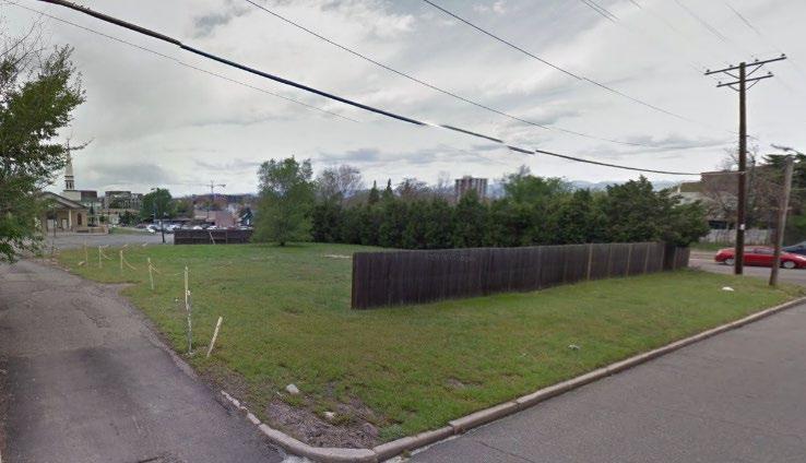
 Area of Property: 12,500 square feet or 3.")
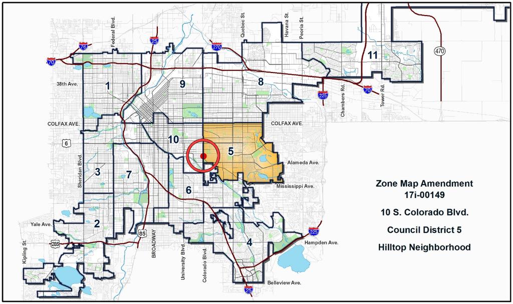
1 TO: Denver City Council Land Use, Transportation and Infrastructure Committee FROM: Theresa Lucero, Senior City Planner DATE: RE: Official Zoning Map Amendment Application #2017I Staff Report and Recommendation Based on the criteria for review in the Denver Zoning Code, Staff recommends approval for Application #2017I Request for Rezoning Address: Neighborhood/Council District: Hilltop Neighborhood / Council District 5 RNOs: Cranmer Park Hilltop Civic Association; Hilltop Heritage Association; Cherry Creek East Association, Inter-Neighborhood Cooperation (INC) Area of Property: 12,500 square feet or 3.48 acres Current Zoning: E-SU-D Proposed Zoning: E-TU-C Property Owner(s): 10 Colorado LLC Owner Representative: Mike Kortendick Summary of Rezoning Request The subject property is vacant and located at the southeast corner of South Colorado Boulevard and East Ellsworth Avenue. The property owner is proposing to rezone the property to develop two duplex structures on the property with a total of 4 dwelling units. The E-TU-C, Urban Edge, Two-unit, C (5,500 square feet minimum zone lot size for Duplex), zone district is intended for use in the Urban Edge Neighborhood Context which is characterized by a mix of urban and suburban characteristics with primarily single and two-unit residential land uses, and small-scale multi-unit residential and commercial areas embedded in residential areas. Single-unit structures in the zone district are the Urban House form with allowed Tandem House forms, and the allowed two-unit building form is the Duplex form on minimum zone lots of 5,500 square feet (See the table below). Further details of the zone district can be found in Article 4 of the Denver Zoning Code. Urban Edge (E) Neighborhood Context Zone District Building Forms Suburban House Urban House Duplex Tandem House Row House Garden Court Town House Apartment Drive Thru Services Drive Thru Restaurant General Shopfront Max Number of Primary Structures Per Zone Lot Two Unit (TU) 1* 1* 1* 2 No Maximum E-TU-B, C *See Section for exceptions Planning Services Community Planning and Development 201 W. Colfax Ave., Dept. 205 Denver, CO p
2 Page 2

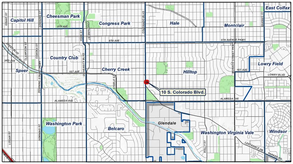
3 Page 3 1. Existing Context The subject property is on the southeast corner of East Ellsworth Avenue and South Colorado Boulevard. In the general vicinity are: East 1 st Avenue one block north; South Leetsdale Drive ½ block south; East Alameda Avenue 2 ½ blocks south; Cranmer Park 3 blocks northeast; Burns Park ½ block south; Cherry Creek 5 blocks south; Gates Tennis Center and Pulaski Park 6 blocks west; and Cherry Creek Shopping Center 8 blocks west.

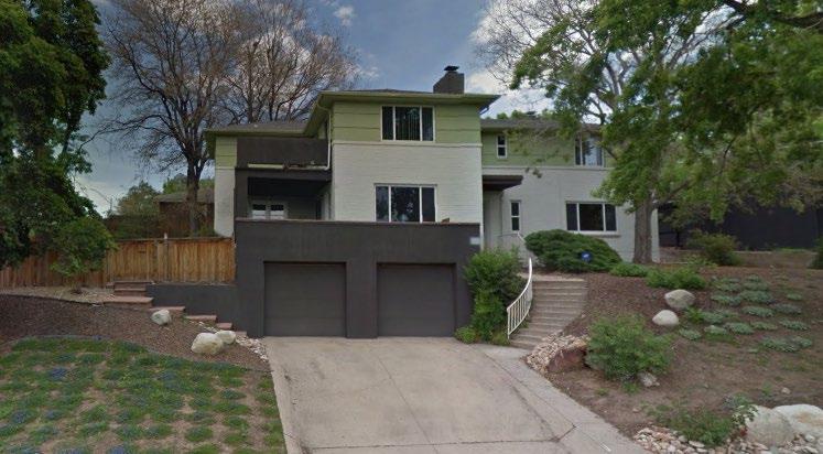
4 Page 4 The following table summarizes the existing context proximate to the subject site: Existing Zoning Existing Land Use Site E-SU-D Vacant Vacant North E-SU-D Single-unit Residential South PUD-G #17 Vacant Vacant East West E-SU-D G-RH-3 Single-unit Residential Single- and Multiunit Residential Existing Building Form/Scale 2-story Residences 1-2 story Residences 1-2 story Residences Existing Block, Lot, Street Pattern Block sizes and shapes are consistent and rectangular and shaped by a grid street pattern. Leetsdale Drive angles into Colorado Boulevard from the east at the southern end of the block. Lack of sidewalks and alleys to the east, regular attached and detached sidewalks and alleys to the west. Garage and on-street vehicle parking. 2. Existing Zoning
5 Page 5 Urban Edge (E) Neighborhood Context Zone District Building Forms Suburban House Urban House Duplex Tandem House Row House Garden Court Town House Apartment Drive Thru Services Drive Thru Restaurant General Shopfront Max Number of Primary Structures Per Zone Lot 1* 1* 1* 2 No Maximum Single Unit (SU) E-SU-D *See Section for exceptions The E-SU-D zone district is a single-unit district allowing only the Urban House building form on a minimum 6,000 square feet zone lot. The intent of the district is to promote and protect residential neighborhoods within the character of the Urban Edge Neighborhood Context. The standards of the single unit districts accommodate the varied pattern of suburban and urban house forms. While lot sizes vary, lot coverage is typically low creating generous setbacks and yard space. 3. Existing Land Use Map Existing Land Use


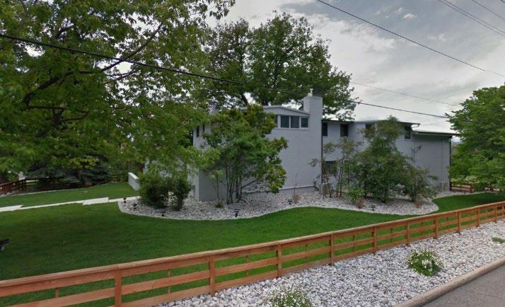
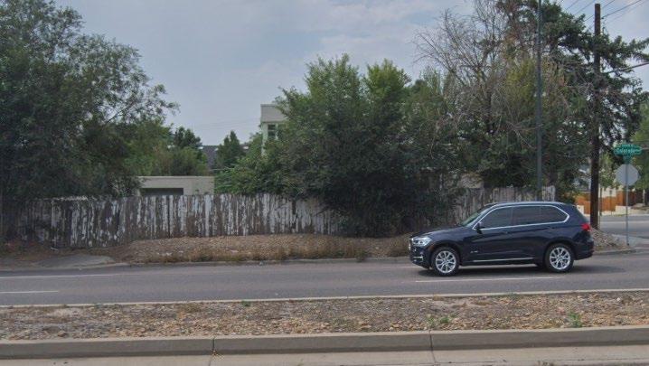
6 Page 6 4. Existing Building Form and Scale
7 Page 7 Summary of City Agency Referral Comments As part of the DZC review process, the rezoning application is referred to potentially affected city agencies and departments for comment. A summary of agency referral responses follows: Assessor: Approved No Response. Asset Management: Approved No Response. Denver Public Schools: Approved No Response. Department of Public Health and Environment: Approved - See Comments Below. Notes. DDPHE is not aware of environmental concerns on the property and concurs with the rezoning request. General Notes: Most of Colorado is high risk for radon, a naturally occurring radioactive gas. Due to concern for potential radon gas intrusion into buildings, DEH suggests installation of a radon mitigation system in structures planned for human occupation or frequent use. It may be more cost effective to install a radon system during new construction rather than after construction is complete. If renovating or demolishing existing structures, there may be a concern of disturbing regulated materials that contain asbestos or lead-based paint. Materials containing asbestos or lead-based paint should be managed in accordance with applicable federal, state and local regulations. The Denver Air Pollution Control Ordinance (Chapter 4- Denver Revised Municipal Code) specifies that contractors shall take reasonable measures to prevent particulate matter from becoming airborne and to prevent the visible discharge of fugitive particulate emissions beyond the property on which the emissions originate. The measures taken must be effective in the control of fugitive particulate emissions at all times on the site, including periods of inactivity such as evenings, weekends, and holidays. Denver s Noise Ordinance (Chapter 36 Noise Control, Denver Revised Municipal Code) identifies allowable levels of noise. Properties undergoing Re-Zoning may change the acoustic environment, but must maintain compliance with the Noise Ordinance. Compliance with the Noise Ordinance is based on the status of the receptor property (for example, adjacent Residential receptors), and not the status of the noise-generating property. Violations of the Noise Ordinance commonly result from, but are not limited to, the operation or improper placement of HV/AC units, generators, and loading docks. Construction noise is exempted from the Noise Ordinance during the following hours, 7am 9pm (Mon Fri) and 8am 5pm (Sat & Sun). Variances for nighttime work are allowed, but the variance approval process requires 2 to 3 months. For variance requests or questions related to the Noise Ordinance, please contact Paul Riedesel, Denver Environmental Health ( ). Scope & Limitations: DEH performed a limited search for information known to DEH regarding environmental conditions at the subject site. This review was not intended to conform to ASTM standard practice for Phase I site assessments, nor was it designed to identify all potential environmental conditions. In addition, the review was not intended to assess environmental conditions for any potential right-of-way or easement conveyance process. The City and County of Denver provides no representations or warranties regarding the accuracy, reliability, or completeness of the information provided. Development Services Fire Prevention: Approved No Response.
8 Page 8 Development Services Project Coordination: Approved - See Comments Below. This project will be reviewed by the one and two family group; however it should be noted, there is no public alley abutting this property as shown on their plan. Development Services - Transportation: Approved No comments. Development Services Wastewater: Approved No Response. Parks and Recreation: Approved No Response. Public Works ROW - City Surveyor: Approved No comments. Public Review Process CPD informational notice of receipt of the rezoning application to all affected members of City Council, registered neighborhood organizations, and property owners: CPD informational notice of receipt of a REVISED rezoning application to all affected members of City Council, registered neighborhood organizations, and property owners: Property legally posted for a period of 15 days and CPD written notice of the Planning Board public hearing sent to all affected members of City Council, registered neighborhood organizations, and property owners: Planning Board public hearing with a unanimous vote (8-0) to recommend approval: CPD written notice of the Land Use, Transportation and Infrastructure Committee meeting sent to all affected members of City Council and registered neighborhood organizations, at least ten working days before the meeting: Land Use, Transportation and Infrastructure Committee of the City Council meeting: Property legally posted for a period of 21 days and CPD notice of the City Council public hearing sent to all affected members of City Council and registered neighborhood organizations: Date 01/25/18 12/28/18 02/18/19 03/06/19 03/05/19 03/19/19 04/07/19 (Tentative) City Council Public Hearing: 04/29/19 (Tentative)
9 Page 9 The applicant has met with representatives of the Cranmer Park Hilltop Civic Association. Registered Neighborhood Organizations (RNOs) o To date, staff has received one letter of support from the Cranmer Park Hilltop Civic Association, a Registered Neighborhood Association (See the attached letter). Other Public Comment o To date, staff has received no other public comment letters. Criteria for Review / Staff Evaluation The criteria for review of this rezoning application are found in DZC, Sections and , as follows: DZC Section Consistency with Adopted Plans 2. Uniformity of District Regulations and Restrictions 3. Public Health, Safety and General Welfare DZC Section Justifying Circumstances 2. Consistency with Neighborhood Context Description, Zone District Purpose and Intent Statements 1. Consistency with Adopted Plans The public hearing schedule for the subject property is such that the Planning Board public hearing will occur prior to the adoption of the Denveright Plans, Comprehensive Plan 2040 and Blueprint Denver 2019, which is anticipated to be April 22, On this schedule the City Council public hearing for the rezoning of the property will be after the adoption of the Denveright Plans. The following adopted plans currently apply to this property if the rezoning is approved prior to the anticipated adoption of the Denveright plans (April 22, 2019): Denver Comprehensive Plan 2000 Blueprint Denver (2002) If the proposed map amendment is approved by City Council after the adoption of the Denveright plans (anticipated April 22, 2019), the following plans would apply instead: Denver Comprehensive Plan 2040 Blueprint Denver (2019) The following plan will apply to this property both before and after April 22, 2019: The Boulevard Plan (1991) Denver Comprehensive Plan 2000 The proposal is consistent with many Denver Comprehensive Plan strategies, including: Environmental Sustainability Strategy 2-F Conserve land by promoting infill development within Denver at sites where services and infrastructure are already in place (p. 39).
10 Page 10 Land Use Strategy 3-B Encourage quality infill development that is consistent with the character of the surrounding neighborhood; that offers opportunities for increased density and more amenities; and that broadens the variety of compatible uses (p. 60). Legacies Strategy 3-A Identify areas in which increased density and new uses are desirable and can be accommodated (p. 99). Housing Objective 2 Encourage preservation and modernization of Denver s existing housing stock and established neighborhoods. Support addition of housing in expansion and infill development (p. 114). The proposed map amendment will enable the addition of low-scale two-unit residential development on the edge of the Hilltop neighborhood at an infill location where services and infrastructure are already in place. The proposed zone district matches the same 30 to 35 feet maximum allowed building height in the adjacent neighborhood. The proposal offers an opportunity to add moderate density in a location that serves as a transition to an arterial street, Colorado Boulevard, and to the Cherry Creek neighborhood west of the Boulevard. The rezoning is consistent with the Comprehensive Plan policies that encourage infill development where services and infrastructure are already in place, where the infill development is in character with the existing neighborhood, where increased density can be accommodated and where additional housing is supported. Denver Comprehensive Plan 2040 Although Comprehensive Plan 2040 is not yet adopted, it is anticipated to be considered by City Council by the time this map amendment would be scheduled at City Council for a public hearing and would be relevant to this request. As such, this staff report provides an analysis of the most current public draft of the plan, January 7, 2019, and the proposed rezoning is consistent with many of the draft Denver Comprehensive Plan 2040 strategies, including: Equitable, Affordable and Inclusive, Goal 1, Strategy A Increase development of housing units close to transit and mixed use development (p. 28). Equitable, Affordable and Inclusive, Goal 2, Strategy A Create a greater mix of housing options in every neighborhood for all individuals and families (p.28). Strong and Authentic Neighborhoods Goal 1, Strategy B Ensure neighborhoods offer a mix of housing types and services for a diverse population (p.34). Strong and Authentic Neighborhoods Goal 1, Strategy D Encourage quality infill development that is consistent with the surrounding neighborhoods and offers opportunities for increased amenities (p. 34). Environmentally Resilient Goal 8, Strategy A - Promote infill development where infrastructure and services are already in place (p.54). The proposed map amendment will enable mixed-use development at an infill location where infrastructure is already in place. The requested E-TU-C zone district broadens the variety of housing options close to a priority transit corridor allowing residents a diversity of housing choice that is in character with the existing neighborhood. Therefore the rezoning is consistent with Denver Comprehensive Plan 2040 recommendations. Blueprint Denver (2002) According to the 2002 Plan Map adopted in Blueprint Denver, the subject property has a concept land use of Single Family/Duplex Residential and is in an Area of Change.
.")
11 Page 11 Future Land Use Single Family/Duplex Residential areas are moderately dense areas that are primarily residential but with some complementary, small-scale commercial uses...there is a mixture of housing types including single-family houses, duplexes, townhouses and small apartment buildings (p. 42). The E-TU-C zone district standards allow a moderate step up in density on the subject property by allowing a similar mix of building forms named in the description of the Single Family/Duplex Residential land use type, Urban House and Duplex, and the district allows the structures at the same allowed height as the adjacent residential neighborhood. Area of Change / Area of Stability As noted, the subject property is in an Area of Change. Blueprint Denver cites one type of Area of change as areas along corridors with frequent bus service (p. 128). The number 40 bus on this section of Colorado Boulevard arrives every 5-7 minutes. The subject property, because it s on a corridor with frequent bus service, is in an area where land use and transportation are linked. The goal for Areas of Change is to channel growth where it will be beneficial and can best improve access to jobs, housing and services with fewer and shorter auto trips (p. 127). Blueprint Denver provides additional specific strategies for Areas of Change. Applicable strategies include: Contribute to urban design vision o Orientation to the street o Building scale o Transition to adjacent areas, especially Areas of Stability Respect valued attributes of area o Diversity of housing types and process o Parks and Parkways Expand transportation choice
12 Page 12 o Pedestrian/bicycle safety and comfort o Access to transit Improve environmental quality o Tree canopy o Parks and Parkways (p. 142) The rezoning application is consistent with these Blueprint Denver Area of Change strategies. The E-TU-C zoning standards will require orientation to the street and a building scale that is the same as the adjacent Area of Stability. Street Classifications Blueprint Denver classifies Colorado Boulevard as a Mixed-Use Arterial and an Enhanced Transit Corridor, and Ellsworth Avenue is classified as an Undesignated Local Street. Mixed Use Arterials provide a high degree of mobility (p. 51) and are located in high-intensity mixed-use commercial retail and residential areas with substantial pedestrian activity (p. 57). Blueprint Denver encourages evaluating and implementing enhanced bus transit service (p. 98) on Enhanced Transit Corridors like Colorado Boulevard, and developing transit-supportive incentives like shared or reduced parking, and a mix of transit-supportive land uses (p. 100). Local Streets are tailored more to providing local access (p. 51). The proposed map amendment to E-TU-C zoning will enable a moderate increase in density in an area that Blueprint Denver identifies as appropriate for change. Future residential development will be oriented to the street, will add to the diversity of housing in the area at the same scale as adjacent residential uses, and will improve the Colorado Boulevard parkway with pedestrian and landscaping enhancements. Blueprint Denver (2019) Although not yet adopted by City Council, Blueprint Denver 2019 is anticipated to be adopted by City Council by the time this map amendment is scheduled for a public hearing by City Council, therefore it is relevant to this request. The proposed rezoning was reviewed for consistency with the Blueprint Denver (2019) January 7, 2019 public review draft 2. The draft Blueprint Denver identifies the subject property as part of a Low Medium residential place within the Urban Edge Neighborhood Context and provides guidance from the future growth strategy for the city. Future Neighborhood Context Blueprint Denver 2019, as well as the Denver Zoning Code, are organized by neighborhood contexts. A context-based approach sets guidelines for character-compatible development. On the Blueprint Denver context map the subject property is within an Urban Edge Neighborhood Context. These areas contain elements of both the suburban and urban contexts. They generally contain low-scale multi-unit and commercial areas embedded in 1 to 2-unit residential areas, with regular block patterns (p. 136). The Urban Edge context tends to act as a transition between urban and suburban areas (p. 205).

13 Page 13 The proposed E-TU-C zone district is an Urban Edge zone district and is intended to promote and protect residential neighborhoods within the character of the Urban Edge Neighborhood Context. The building form standards, design standards and uses work together to promote desirable residential areas. While lot sizes vary, lot coverage is typically low creating generous setbacks and yard space. The standards of the two unit and row house districts promote existing and future patterns of lower scale multi-unit building forms that typically address the street in the same manner as an urban house building form. These regulations are also intended to reinforce desired development patterns in existing neighborhoods while accommodating reinvestment (p & 2). The zoning standards within the E-TU-C zone district that allow low-scale multi-unit structures will be compatible with the existing residential area, and consistent with the Blueprint Denver context.
14 Page 14 Future Places The subject property is within a Low-Medium residential future place. Per Blueprint Denver Future places are an organizational system that describes the desired character of an area. Future places work together to promote complete neighborhoods for the residents living within or near each of them. Each place expresses itself differently depending on which neighborhood context it is located within. Residential areas have a predominantly residential land use but are supported by a variety of embedded uses needed for a complete neighborhood including schools, recreation and nodes of commercial/retail uses (p. 141). Per Blueprint Denver low-medium residential areas in the Urban Edge Context are a Mix of low- to mid-scale multi-unit residential options. Small-scale multi-unit buildings are interspersed between single- and two-unit residential. Limited mixed-use along residential arterial and collector streets and at some intersections. Vacant institutional uses on corners or select sites may be appropriate locations to introduce additional residential intensity. Buildings are generally 3 stories or less in height. When occurring, single- and two-unit residential uses are typically in the urban house form (p. 216). The E-TU-C zone district allows low-scale residential uses with a maximum height of 2.5 stories, or up to 35 feet, in conformance with the low-medium residential Urban Edge place type. Street Types Blueprint Denver 2019 classifies Colorado Boulevard as a Residential Arterial street and Ellsworth Avenue as a Local or Undesignated street. Residential streets have Primarily residential uses, but may include schools, civic uses, parks, small retail nodes and other similar uses. Buildings on residential streets usually have a modest setback (p. 160). Regarding Ellsworth Avenue, Blueprint Denver states, Local streets are designed for the highest degree of property access and the lowest amount of through
15 Page 15 movement (p. 154). Blueprint Denver also notes the unique quality of streets that are designated parkways as Colorado Boulevard is adjacent to the subject property. Within the Urban Edge Context the predominate street types are mixed use, commercial and residential. The proposed E-TU-C district allows primarily residential and civic uses and includes modest primary street setbacks. Therefore, itis consistent with the Urban Edge residential arterial and local street types at this site. Growth Strategy The subject property is within a low-medium residential place type, and All other areas of the city on the Growth Strategy map. These types of places are anticipated to see around 20% of new housing growth and 10% of new employment growth by 2040 (p. 51). The remaining growth areas are smaller but still play a key role in meeting the diversity of new job and housing needed for our dynamic city. Higher intensity residential areas near downtown, mid-scale housing in innovation/flex districts and lowscale greenfield residential all contribute to Denver s future housing stock. The remaining parts of Denver, mostly residential areas with embedded local centers and corridors, take a smaller amount of growth intended to strengthen the existing character of our neighborhoods (p. 49). The proposed map amendment to E-TU-C will will allow low-intensity growth in a low-medium place where it is in character with the exiting area. The Boulevard Plan (1991) The Boulevard Plan outlines visions, goals and objectives mainly for the commercially zoned property along Colorado Boulevard between 1 st Avenue on the north and Iliff Avenue on the south. The overall vision of the Plan is that this portion of Colorado Boulevard is and should continue to be, a regionally distinct transportation, business and residential corridor accommodating a wide range of development types and sizes which serve the shopping, business and entertainment needs of nearby residents, as

16 Page 16 well as providing destination opportunities for a wider community (p. 3). Plan goals to achieve this vision include: Improving traffic flow and safety Retain a broad mix of land uses Define and reinforce the unique image of the corridor and ensure that new development has no adverse impacts on adjacent uses Three areas of concern identified in the Plan Goals are transportation, land use and urban design. The transportation recommendations in the Plan are mainly oriented to physical improvements within the corridor, improvements to support corridor transit and attempts to manage trip generation. Urban design recommendations in the Plan center mainly on physical improvements in the corridor to improve the public right-of-way, signage, landscaping and the quality of private development on the corridor. The general land use goals in the Plan include Continue an appropriate mix of land uses along the Boulevard and New development should be compatible with existing development (p. 29). Plan land use recommendations include: Overall Development Cap While no wholesale increases in overall allowable development seem appropriate, some increase in development intensity may be appropriate for individual projects because of specific site or development proposal issues (p. 35). Land Use Mix Seek to retain a diversity of land uses in the corridor (p. 36). On-Site Parking All new development should provide sufficient parking to meet 100% of the project s needs on-site or in shared facilities adjacent to the site (p. 36). The proposed rezoning of the subject property complies with these recommendations because the proposed duplex development will add to the mix of residential development types on the corridor, will add a moderate level of development that is in character with the adjacent neighborhoods and will provide 100% of the project s parking needs on-site. 2. Uniformity of District Regulations and Restrictions The proposed rezoning to E-TU-C will result in the uniform application of zone district building form, use and design regulations. 3. Public Health, Safety and General Welfare The proposed official map amendment furthers the public health, safety, and general welfare of the City by allowing a moderate level of reinvestment in the area consistent with the desired character and by implementing the city s adopted land use plans. 4. Justifying Circumstance The application identifies changed or changing conditions as the Justifying Circumstance under DZC Section A.4, Since the date of the approval of the existing zone district, there has been a change to such a degree that the proposed rezoning is in the public interest. Such change may include: Changed or changing conditions in a particular area, or in the city generally; or a city adopted
17 Page 17 plan; or that the city adopted the Denver Zoning Code and the property retained Former Chapter 59 zoning. The application identifies changes to the overall city and cites the subject property s location as a transition site between Colorado Boulevard and the existing neighborhood to the east. On the opposite side of Colorado Boulevard the Cherry Creek neighborhood has experienced robust redevelopment with multi-unit residential uses on the Boulevard. In recognizing the citywide changes and changes in the immediate area the application is in conformance with this criterion. Changed conditions in the area is an appropriate justifying circumstance for the proposed rezoning. 5. Consistency with Neighborhoods Context Description, Zone District Purpose and Intent Statements The zoning standards in the proposed zone district are based upon the Urban Edge Neighborhood context. This context is characterized by a mix of urban and suburban characteristics with primarily single and two-unit residential land uses, and small-scale multi-unit residential and commercial areas embedded in residential areas. Single-unit structures in the zone district are the Urban House form with allowed Tandem House forms, and the allowed multi-unit building form is the Duplex form on minimum zone lots of 5,500 square feet. The surrounding area and the recommended neighborhood context both make the proposed rezoning to E-TU-C consistent with the neighborhood context description. The Urban Edge residential zone districts are intended to promote and protect residential neighborhoods within the character of the Urban Edge Neighborhood Context. The building form standards, design standards and uses work together to promote desirable residential areas. The standards of the two unit and row house districts promote existing and future patterns of lower scale multi-unit building forms that typically address the street in the same manner as an urban house building form. These regulations are also intended to reinforce desired development patterns in existing neighborhoods while accommodating reinvestment. The application to rezone to E-TU-C in this location is consistent with the above purpose and intent statement because the rezoning allows lower scale single- and two-uses and building forms consistent with the desired development pattern of the area.
18 Page 18 Attachments 1. RNO Comment Letter 2. Application 3. Legal Description
19
20
Staff Report and Recommendation
 Community Planning and Development Planning Services 201 W. Colfax Ave., Dept. 205 Denver, CO 80202 p: 720.865.2915 f: 720.865.3052 www.denvergov.org/cpd TO: City Council Neighborhoods and Planning Committee
Official Zoning Map Amendment Application #2018I-00047
 Community Planning and Development Planning Services 201 W. Colfax Ave., Dept. 205 Denver, CO 80202 p: 720.865.2915 f: 720.865.3052 www.denvergov.org/cpd TO: Denver Planning Board FROM: Chandler Van Schaack,
Official Zoning Map Amendment Application #2018I-00077
 Community Planning and Development Planning Services 201 W. Colfax Ave., Dept. 205 Denver, CO 80202 p: 720.865.2915 f: 720.865.3052 www.denvergov.org/cpd TO: Denver Planning Board FROM: Scott Robinson,
Denver Land Use, Transportation and Infrastructure Committee FROM: Andrew Webb, Senior City Planner DATE: March 22, 2018 RE:
 Community Planning and Development Planning Services 201 W. Colfax Ave., Dept. 205 Denver, CO 80202 p: 720.865.2915 f: 720.865.3052 www.denvergov.org/cpd TO: Denver Land Use, Transportation and Infrastructure
Staff Report and Recommendation Based on the criteria for review in the Denver Zoning Code, Staff recommends approval for Application #2018I
 Community Planning and Development Planning Services 201 W. Colfax Ave., Dept. 205 Denver, CO 80202 p: 720.865.2915 f: 720.865.3052 www.denvergov.org/cpd TO: Denver Planning Board FROM: Sara White, AICP,
2 nd & St Paul, LLC and BAH-PLA, LLC
 Community Planning and Development Planning Services 201 W. Colfax Ave., Dept. 205 Denver, CO 80202 p: 720.865.2915 f: 720.865.3052 www.denvergov.org/cpd TO: Denver City Council FROM: Theresa Lucero, Senior
, C-MS I June 3, 2016 $1500 pd chk #216918
 , C-MS-8 LOTS 21 THROUGH 40, INCLUSIVE, BLOCK 299 CLEMENTS ADDITION TO THE CITY OF DENVER SOUTHEAST QUARTER OF SECTION 34, TOWNSHIP 3 SOUTH, RANGE 68 WEST, SIXTH PRINCIPAL MERIDIAN, CITY
TO: Denver Planning Board FROM: Analiese Hock, Senior City Planner DATE: March 13, 2018 RE:
 Community Planning and Development Planning Services 201 W. Colfax Ave., Dept. 205 Denver, CO 80202 p: 720.865.2915 f: 720.865.3052 www.denvergov.org/cpd TO: Denver Planning Board FROM: Analiese Hock,
Planning Services Community Planning and Development 201 W. Colfax Ave., Dept. 205 Denver, CO p
 TO: Denver Planning Board, Julie Underdahl, Chair FROM: Theresa Lucero, Senior City Planner DATE: RE: Official Zoning Map Amendment Application #2017I-00042 Staff Report and Recommendation Based on the
To: S-MX-8 AIO, S-MX-8A AIO, S-MX-12 AIO, C-MX-8 AIO, C-MX-12 AIO, and S-CC-5 AIO
 Community Planning and Development Planning Services 201 W. Colfax Ave., Dept. 205 Denver, CO 80202 p: 720.865.2915 f: 720.865.3052 www.denvergov.org/cpd TO: City Council Neighborhoods and Planning Committee
#2017I E-RH-2.5 Highland Ventures Holdings, LLC and Irving Estates, LLC
 TO: Denver Planning Board - Joel Noble, Chair FROM: Theresa Lucero, Senior City Planner DATE: RE: Official Zoning Map Amendment Application #2017I-00178 1080 and 1090 King Street Rezoning from E-SU-D1x
Official Zoning Map Amendment Application #2018I-00075
 Community Planning and Development Planning Services 201 W. Colfax Ave., Dept. 205 Denver, CO 80202 p: 720.865.2915 f: 720.865.3052 www.denvergov.org/cpd TO: Denver Planning Board FROM: Scott Robinson,
TO: Denver Planning Board FROM: Chandler Van Schaack, Senior City Planner DATE: March 27, 2019 RE:
 Community Planning and Development Planning Services W. Colfax Ave., Dept. Denver, CO 0 p:.. f:..0 www.denvergov.org/cpd TO: Denver Planning Board FROM: Chandler Van Schaack, Senior City Planner DATE:
Staff Report and Recommendation
 Community Planning and Development Planning Services 201 W Colfax Ave, Dept 205 Denver, CO 80202 p: 720-865-2972 f: 720-865-3056 www.denvergov.org/planning TO: LUTI FROM: Steve Nalley, Senior City Planner
REZONING GUIDE. Zone Map Amendment (Rezoning) - Application. Rezoning Application Page 1 of 3. Return completed form to
 - Application. Rezoning Application Page 1 of 3. Return completed form to") Zone Map Amendment (Rezoning) - Application COMMUNITY PLANNING & DEVELOPMENT REZONING GUIDE Rezoning Application Page 1 of 3 PROPERTY OWNER INFORMATION* CHECK IF POINT OF CONTACT FOR APPLICATION Property
Zone Map Amendment (Rezoning) - Application COMMUNITY PLANNING & DEVELOPMENT REZONING GUIDE Rezoning Application Page 1 of 3 PROPERTY OWNER INFORMATION* CHECK IF POINT OF CONTACT FOR APPLICATION Property
September 25th, 2018 $2000 fee pd CC
 2.7267 acres 2018I-00075 September 25th, 2018 $2000 fee pd CC Rezoning Review Criteria Analysis - Map Amendment Application Number: 2018I-00075 805 W. 38 th Avenue October 19, 2018 (amd.) September 17,
CONTENTS 8.0 LAND USE 8.1 GENERAL LAND USE 8.2 RESIDENTIAL 8.3 MIXED USE 8.4 COMMERCIAL 8.5 EMPLOYMENT LANDS
 8-2 Land Use 8.0 LAND USE CONTENTS 8.1 GENERAL LAND USE 8.1.1 Uses provided for in all Land Use Designations 8.1.2 Uses prohibited in Hazardous Lands, Hazardous Sites and Special Policy Areas 8.1.3 Uses
Steering Committee Meeting
 Neighborhood Planning Initiative NPI EAST CENTRAL AREA PLAN Steering Committee Meeting November 9, 2017 6:00PM 8:00PM Tears McFarlane House East Central Area Plan Steering Committee Meeting 11/9/17 AGENDA
TO: Staff Report and Recommendation
 Community Planning and Development Planning Services 201 W. Colfax Ave., Dept. 205 Denver, CO 80202 p: 720.865.2915 f: 720.865.3052 www.denvergov.org/cpd TO: City Council Neighborhoods and Planning Committee
#2017I E-RH-2.5 Highland Ventures Holdings, LLC and Irving Estates, LLC
 TO: Denver City Council Land Use, Transportation, and Infrastructure Committee FROM: Theresa Lucero, Senior City Planner DATE: January 3, 2019 RE: Official Zoning Map Amendment Application #2017I-00178
Staff Report and Recommendation
 Community Planning and Development Planning Services 201 W. Colfax Ave., Dept. 205 Denver, CO 80202 p: 720.865.2915 f: 720.865.3052 www.denvergov.org/cpd TO: Denver City Council FROM: Steve Nalley, Neighborhood
City Of Sparks Planning Commission Item
 Page 1 of 12 City Of Sparks Planning Commission Item Meeting Date: May17, 2012 Subject: PCN12009, Public Hearing, Consideration and possible action on a Master Plan Amendment and Rezoning request to change
VILLAGE OF CLEMMONS PLANNING BOARD DRAFT STAFF REPORT
 VILLAGE OF CLEMMONS PLANNING BOARD DRAFT STAFF REPORT PETITION INFORMATION Docket # C-226 Staff Megan Ledbetter Petitioner(s) JBJH Properties, LLC Owner(s) JBJH Properties, LLC Subject Property 5892-49-1766
AWH REPORT OF THE PLANNING AND DEVELOPMENT DEPARTMENT FOR APPLICATION FOR REZONING ORDINANCE TO PLANNED UNIT DEVELOPMENT
 AWH REPORT OF THE PLANNING AND DEVELOPMENT DEPARTMENT FOR APPLICATION FOR REZONING ORDINANCE TO PLANNED UNIT DEVELOPMENT MAY 8, 2014 The Planning and Development Department hereby forwards to the Planning
REZONING GUIDE. Zone Map Amendment (Rezoning) - Application. Rezoning Application Page 1 of 3. Return completed form to
 - Application. Rezoning Application Page 1 of 3. Return completed form to") Zone Map Amendment (Rezoning) - Application COMMUNITY PLANNING & DEVELOPMENT REZONING GUIDE Rezoning Application Page 1 of 3 PROPERTY OWNER INFORMATION* CHECK IF POINT OF CONTACT FOR APPLICATION Property
Zone Map Amendment (Rezoning) - Application COMMUNITY PLANNING & DEVELOPMENT REZONING GUIDE Rezoning Application Page 1 of 3 PROPERTY OWNER INFORMATION* CHECK IF POINT OF CONTACT FOR APPLICATION Property
Official Zoning Map Amendment Application #2018I-00131
 Community Planning and Development Planning Services 201 W. Colfax Ave., Dept. 205 Denver, CO 80202 p: 720.865.2915 f: 720.865.3052 www.denvergov.org/cpd TO: Denver Planning Board FROM: Kristofer Johnson,
A. WHAT IS A GENERAL PLAN?
 I. Introduction A. WHAT IS A GENERAL PLAN? A general plan is the planning guideline for the future of a city. It contains goals and policies which regulate urban development, the protection of the natural
C. Westerly Creek Village & The Montview Corridor
 C. Westerly Creek Village & The VISION Community Vision When the goals of the city are achieved Westerly Creek Village, a distinctive community defined by Montview Boulevard and Westerly Creek, is a strong
CHAPTER 7: VISION AND ACTION STATEMENTS. Noble 2025 Vision Statement
 CHAPTER 7: VISION AND ACTION STATEMENTS This chapter presents the vision, policy and action statements that transform the comprehensive planning study, an analysis of Noble s past, future trends and community
East Central Area Plan
 East Central Area Plan Steering Committee Meeting March 8 th, 2018 CHUN Tears McFarlane House Vision Statement Development Opportunities Analysis Vision Elements 1. Equitable, Affordable and Inclusive
Town Center (part of the Comprehensive Plan)
") Town Center (part of the Comprehensive Plan) Mercer Island Town Center Looking North (2014) In 1994, a year-long process culminated in a set of design guidelines and code requirements for the Town Center
Town Center (part of the Comprehensive Plan) Mercer Island Town Center Looking North (2014) In 1994, a year-long process culminated in a set of design guidelines and code requirements for the Town Center
4.1.3 LAND USE CATEGORIES
 4.1.3 LAND USE CATEGORIES a. City Center District The City Center District incorporates the existing character and mix of uses in downtown Belmont to encourage redevelopment and new development in keeping
DENVER DESIGN DISTRICT GDP
 DENVER DESIGN DISTRICT GDP Urban Design Standards and Guidelines November 17, 2008 Amended February 3, 2016 City and County of Denver CF Property Management, Inc. C/O Denver Design District - Starboard
BUILDING SCALE AND SETBACKS 5 ELEMENTS:... 5 FAÇADES (COMMERCIAL/RESIDENTIAL) 5
 5") VISION STATEMENT 3 UTILIZATION OF THE GUIDELINES 3 IMPLEMENTATION 3 PROCEDURES FOR DESIGN REVIEW 3 LAND USE AND ZONING 4 LAND USE 4 ELEMENTS:... 4 ZONING 4 ELEMENTS:... 4 BUILDING SCALE AND SETBACKS 5
VISION STATEMENT 3 UTILIZATION OF THE GUIDELINES 3 IMPLEMENTATION 3 PROCEDURES FOR DESIGN REVIEW 3 LAND USE AND ZONING 4 LAND USE 4 ELEMENTS:... 4 ZONING 4 ELEMENTS:... 4 BUILDING SCALE AND SETBACKS 5
PORT WHITBY COMMUNITY
 PORT WHITBY COMMUNITY SECONDARY PLAN UPDATE COMMUNITY IMPROVEMENT PLAN URBAN DESIGN GUIDELINES September 2015 DRAFT PROPOSED AMENDMENT NUMBER # to the Whitby Official Plan PURPOSE: The intent of this Amendment
DRAFT. 10% Common Open Space
 % OF CHARLOTTE IS CATEGORIZED AS A. LAND USES : Placeholder map displaying location of Place Type GOALS: Accommodate XX% of future growth. Provide a concentration of primarily commercial and civic activity
SECTION UNIFIED DEVELOPMENT ORDINANCE SECTION Part 1 Ordinance. ARTICLE 1 Zoning Districts
 SECTION 1-100 UNIFIED DEVELOPMENT ORDINANCE SECTION 1-300 Part 1 Ordinance SECTION 1-100. Introduction. ARTICLE 1 Zoning Districts Crystal Lake strives to maintain a balance of various land uses for a
CITY OF PUYALLUP. Background. Development Services
 CITY OF PUYALLUP Development Services 333 South Meridian Puyallup WA 98371 To: City Council From: Katie Baker, AICP, Planning Division Re: South Hill Neighborhood Plan Adoption Date: (Meeting date: February
Chapter 1 - General Design Guidelines CHAPTER 1 GENERAL DESIGN GUIDELINES
 CHAPTER 1 GENERAL DESIGN GUIDELINES 1.0 INTRODUCTION This Publication has been developed to provide current, uniform procedures and guidelines for the application and design of safe, convenient, efficient
FUTURE LAND USE ELEMENT
 FUTURE LAND USE ELEMENT GOAL I: To create and sustain a great place to live, play, and prosper Objective 1: The City of Ocala shall incorporate the principles and strategies of the Ocala 2035 Vision into
CPD Rules and Regulations. Arapahoe Square Zoning and Design Standards/Guidelines
 CPD Rules and Regulations Arapahoe Square Zoning and Design Standards/Guidelines Denver Planning Board May 4 th, 2016 Sponsor & Community Partners Sponsored by Albus Brooks, Council District 9 Developed
PLANNED UNIT DEVELOPMENT & SUBDIVISION STAFF REPORT Date: May 18, 2017
 & PUD-0000102-2017 PLANNED UNIT DEVELOPMENT & SUBDIVISION STAFF REPORT Date: May 18, 2017 NAME SUBDIVISION NAME Dauphin Creek Estates Subdivision Dauphin Creek Estates Subdivision LOCATION CITY COUNCIL
Official Plan Review: Draft Built Form Policies
 PG.30.1 REPORT FOR ACTION Official Plan Review: Draft Built Form Policies Date: May 15, 2018 To: Planning and Growth Management Committee From: Chief Planner and Executive Director, City Planning Division
PLANNING COMMISSION REPORT
 PLANNING COMMISSION REPORT REZONING CASE NO. RZ-14-002 REPORT DATE: February 10, 2015 CASE NAME: 9990 W. Alameda Ave. Rezoning PLANNING COMMISSION DATE: February 18, 2015 ADDRESS OF REZONING PROPOSAL:
NEW CASTLE COUNTY S ZONING DISTRICTS
 NEW CASTLE COUNTY S ZONING DISTRICTS This is general information about New Castle County s zoning districts. The information included is by no means exhaustive or complete. Before designing plans to develop
URBAN DESIGN BRIEF. 2136&2148 Trafalgar Road. Town of Oakville
 URBAN DESIGN BRIEF 2136&2148 Trafalgar Road Town of Oakville Prepared By: METROPOLITAN CONSULTING INC For 2500674 Ontario Inc November 2016 TABLE OF CONTENTS Page No. 1.0 Introduction/Description of Subject
ARLINGTON COUNTY, VIRGINIA
 ARLINGTON COUNTY, VIRGINIA County Board Agenda Item Meeting October 15, 2005 DATE: September 28, 2005 SUBJECT: Request to Advertise the adoption of the 2005 Clarendon Sector Plan C. M. RECOMMENDATION:
Mark-up of the effect of the proposed Bronte Village Growth Area OPA No.18 on the text of section 24, Bronte Village, of the Livable Oakville Plan
 Mark-up of the effect of the proposed Bronte Village Growth Area OPA No.18 on the text of section 24, Bronte Village, of the Livable Oakville Plan Notes: This document is provided for information purposes
VILLAGE OF CLEMMONS PLANNING BOARD DRAFT STAFF REPORT. Single Family Residential, Townhomes
 VILLAGE OF CLEMMONS PLANNING BOARD DRAFT STAFF REPORT PETITION INFORMATION Docket # C-212 Staff Megan Ledbetter Petitioner(s) Peacehaven Development LLC Owner(s) Larry Jarvis, William Alexander and Peacehaven
Official Plan Review
 Official Plan Review Summary Report - The Built Environment August 2014 Part 1: Introduction Planning for a healthy, prosperous and sustainable community is an important goal for our municipality. From
5 TOWN OF MARKHAM OFFICIAL PLAN AMENDMENT NO. 144 MILLIKEN MAIN STREET SECONDARY PLAN
 5 TOWN OF MARKHAM OFFICIAL PLAN AMENDMENT NO. 144 MILLIKEN MAIN STREET SECONDARY PLAN The Planning and Economic Development Committee recommends the following: 1. The communication from Brendan O Callaghan,
Tyvola & Archdale Transit Station Area Plan. June 5, 2008
 Tyvola & Archdale Transit Station Area Plan Second Public Meeting June 5, 2008 Presentation Outline 1. Purpose and Process 2. Station Area Overview 3. Plan Recommendations 4. Comments Received and Proposed
Land Use Amendment in Southwood (Ward 11) at and Elbow Drive SW, LOC
 at and Elbow Drive SW, LOC") 2018 November 15 Page 1 of 10 EXECUTIVE SUMMARY This land use amendment application was submitted by Rick Balbi Architect on 2017 August 31 on behalf of Sable Developments Ltd, and with authorization from
2018 November 15 Page 1 of 10 EXECUTIVE SUMMARY This land use amendment application was submitted by Rick Balbi Architect on 2017 August 31 on behalf of Sable Developments Ltd, and with authorization from
EXISTING COMPREHENSIVE PLAN
 EXISTING COMPREHENSIVE PLAN Town Center Land Use Element: V. LAND USE POLICIES Town Center Mercer Island's business district vision as described in "Your Mercer Island Citizen-Designed Downtown" was an
A Growing Community Rural Settlement Areas
 Town of Huntsville Official Plan Review - POLICY BACKGROUND PAPER A Growing Community Rural Settlement Areas BACKGROUND: In addition to the fully municipally-serviced Urban Settlement Area and the Hidden
Public input has been an important part of the plan development process.
 Lakewood s Comprehensive Plan recognizes that transportation helps shape the community, and that the way the community provides for the safe and efficient movement of people affects the character of the
A. Background Summary of Existing Challenges and Potential Possibilities. 1. Summary of Existing Assets and Potential Opportunities
 A. Background 1 A Main Street Master Plan Study was performed and completed in October of 2007. The study was initiated to review current land uses and development patterns along Main Street, from Parrish
Rapid City Planning Commission Rezoning Project Report
 Rapid City Planning Commission Rezoning Project Report July 21, 2016 Applicant Request(s) Case # 16RZ022 Rezoning from Office Commercial District to Light Industrial District Companion Case(s): 16RZ023-Rezoning
Planning & Zoning Commission Staff Report
 Planning & Zoning Commission Staff Report Meeting Date: May 26, 2015 Drafted by: Katherine Harrison-Rogers CASE # Z2886 PROJECT NAME: APPLICANT/ REPRESENTATIVE: Shawna Runyan PROPERTY OWNER: 1840 (previously
RESIDENTIAL DISTRICTS
 RESIDENTIAL DISTRICTS The residential district standards have been revised to reflect on-the-ground conditions, while continuing to respect the use patterns established within the neighborhoods. This will
ROAD CLOSURE AND LAND USE AMENDMENT SILVER SPRINGS (WARD 1) NORTHEAST OF NOSEHILL DRIVE NW AND SILVER SPRINGS ROAD NW BYLAWS 2C2018 AND 29D2018
 NORTHEAST OF NOSEHILL DRIVE NW AND SILVER SPRINGS ROAD NW BYLAWS 2C2018 AND 29D2018") Page 1 of 19 EXECUTIVE SUMMARY This application proposes redesignating two parcels in the community of Silver Springs from Special Purpose Future Urban Development (S-FUD) District and undesignated road
Page 1 of 19 EXECUTIVE SUMMARY This application proposes redesignating two parcels in the community of Silver Springs from Special Purpose Future Urban Development (S-FUD) District and undesignated road
PART III LAND USE POLICIES URBAN PLANNING AREA
 To be read with other parts of the Plan 1.0 INTRODUCTION *D9 This part of the Plan presents the principles, objectives and policies for the land use designations identified on the Settlement Pattern and
Section 9 NEIGHBORHOOD DESIGN
 Section 9 NEIGHBORHOOD DESIGN City of Lancaster Comprehensive Plan D u n k i n, S e f k o & A s s o c i a t e s, I n c. NEIGHBORHOOD DESIGN INTRODUCTION There are many ways in which a neighborhood can
Staff Report to the North Ogden City Planning Commission
 Staff Report to the North Ogden City Planning Commission SYNOPSIS / APPLICATION INFORMATION Application Request: Concept review on a legislative application to rezone land located at approximately 1750
[PLANNING RATIONALE] For Site Plan Control and Lifting of Holding Zone By-Law 101 Champagne Avenue. May 23, 2014
![[PLANNING RATIONALE] For Site Plan Control and Lifting of Holding Zone By-Law 101 Champagne Avenue. May 23, 2014](/thumbs/75/71599615.jpg "[PLANNING RATIONALE] For Site Plan Control and Lifting of Holding Zone By-Law 101 Champagne Avenue. May 23, 2014") [PLANNING RATIONALE] For Site Plan Control and Lifting of Holding Zone By-Law 101 Champagne Avenue May 23, 2014 Contents 1.0 Introduction... 2 2.0 Site Context... 2 2.1 Adjacent Uses... 2 Figure 1: Site
[PLANNING RATIONALE] For Site Plan Control and Lifting of Holding Zone By-Law 101 Champagne Avenue May 23, 2014 Contents 1.0 Introduction... 2 2.0 Site Context... 2 2.1 Adjacent Uses... 2 Figure 1: Site
YONGE STEELES CORRIDOR SECONDARY PLAN. Young + Wright / IBI Group Architects Dillon Consulting Ltd. GHK International (Canada) Ltd.
 Ltd.") PART A: PREAMBLE 1.0 PURPOSE The purpose of this Secondary Plan is to provide a development framework for intensification of the Yonge/ Steeles corridor including the north side of Steeles Avenue West
PART A: PREAMBLE 1.0 PURPOSE The purpose of this Secondary Plan is to provide a development framework for intensification of the Yonge/ Steeles corridor including the north side of Steeles Avenue West
Edward R. Sajecki Commissioner of Planning and Building
 Corporate Report Clerk s Files Originator s Files CD.03.POR DATE: TO: FROM: SUBJECT: Chair and Members of Planning and Development Committee Meeting Date: February 27, 2012 Edward R. Sajecki Commissioner
4780 Eglinton Avenue West - Zoning By-law Amendment and Draft Plan of Subdivision Applications - Preliminary Report
 STAFF REPORT ACTION REQUIRED 4780 Eglinton Avenue West - Zoning By-law Amendment and Draft Plan of Subdivision Applications - Preliminary Report Date: May 29, 2014 To: From: Wards: Reference Number: Etobicoke
Planned Development Review Revisions (Project No. PLNPCM )
") Planned Development Review Revisions (Project No. PLNPCM2014-00139) Standard residential development Planned Development Example: Smaller lot sizes than what is allowed to create open space amenity. What
Planned Development Review Revisions (Project No. PLNPCM2014-00139) Standard residential development Planned Development Example: Smaller lot sizes than what is allowed to create open space amenity. What
Blueprint Denver A BLUEPRINT FOR AN INCLUSIVE CITY. Executive Summary
 Blueprint Denver A BLUEPRINT FOR AN INCLUSIVE CITY Executive Summary PUBLIC REVIEW DRAFT 2 1/7/2019 DENVERIGHT BLUEPRINTDENVER Blueprint Denver: A Blueprint for an Inclusive City An Equitable City Planning
2040 LUP is a part of the Comprehensive Plan and carries the same legal authority. Economic Challenges
 1.1. Guiding Anchorage s Growth Where will new residents settle over the next two decades? Where will people work, shop, and play? Will there be enough room to grow? How will Anchorage look? Will growth
Gold Line Bus Rapid Transit Transit Oriented Development (BRTOD) Helmo Station Area Plan
 Helmo Station Area Plan") Appendix F Gold Line Bus Rapid Transit Transit Oriented Development (BRTOD) Helmo Station Area Plan Introduction and Purpose of the Plan The Gold Line Bus Rapid Transit facility is an eleven-mile dedicated
Appendix F Gold Line Bus Rapid Transit Transit Oriented Development (BRTOD) Helmo Station Area Plan Introduction and Purpose of the Plan The Gold Line Bus Rapid Transit facility is an eleven-mile dedicated
Policies and Code Intent Sections Related to Town Center
 Policies and Code Intent Sections Related to Town Center The Town Center Vision is scattered throughout the Comprehensive Plan, development code and the 1994 Town Center Plan. What follows are sections
JWN PlanJam Workshop #1
 Planning for a healthy, vibrant neighborhood community JWN PlanJam Workshop #1 Presented by the Jefferson Westside Neighbors jwneugene.org More information on the Web at: jwneugene.org/infillstds Welcome!
Table of Contents. Elm Avenue Improvement Plan City of Waco, Texas. Introduction 1. Existing Context 1 Figure 1 2.
 Table of Contents Introduction 1 Existing Context 1 Figure 1 2 Plan Guidelines 3 Future Urban Form 4 The West-End 4 Main Street 6 The East-End 7 Figure 2 9 Public Improvement Recommendations 7 General
Town of Cobourg Heritage Master Plan. Statutory Public Meeting
 Town of Cobourg Heritage Master Plan Statutory Public Meeting April 25 th 2016 Presentation Overview 1. Introduction 2. Project background and schedule overview 3. Review of strategic direction content
Prosperity Hucks Area Plan. Transportation and Planning Committee May 11, 2015
 Prosperity Hucks Area Plan Transportation and Planning Committee May 11, 2015 Presentation Outline 1. Background and Location 2. Community Dialog Process 3. Activity Center Recommendations 4. Wedge Recommendations
Commercial Development Proposal Tenth Line Road. Planning Rationale Report. Minto Developments Inc.
 Commercial Development Proposal 2168 Tenth Line Road Report September 2015 Prepared for Minto Developments Inc. Paquette Planning Associates Ltd. 56 Hutchison Avenue Ottawa, Ontario K1Y 4A3 PH: 613-722-7217
2.0 AREA PLANS. Lakeside Business District. Lakeside Business District Land Use Categories:
 Lakeside Business District Lakeside Business District Land Use Categories: Campus Commercial Campus Commercial means a mixture of uses which includes corporate offices, office parks, hotels, commercial,
PLANNED UNIT DEVELOPMENT Date: April 5, 2018
 PLANNED UNIT DEVELOPMENT Date: April 5, 2018 DEVELOPMENT NAME SUBDIVISION NAME LOCATION Robert Myers Robert Myers 2955 and 2989 Dauphin Street (Southeast corner of Dauphin Street and Sage Avenue) CITY
QUEEN-RIVER SECONDARY PLAN
 34 QUEEN-RIVER SECONDARY PLAN 34. QUEEN RIVER SECONDARY PLAN 1. INTRODUCTION The Queen-River area is approximately 6.4 hectares and is located at the eastern edge of the Downtown as shown on Map 34-1.
646 Kingston Road - Official Plan Amendment and Zoning Amendment Applications - Preliminary Report
 STAFF REPORT ACTION REQUIRED 646 Kingston Road - Official Plan Amendment and Zoning Amendment Applications - Preliminary Report Date: December 8, 2014 To: From: Wards: Reference Number: Toronto and East
Request Alternative Compliance to the prescribed criteria of the Oceanfront Resort District Form-Based Code. Staff Planner Kristine Gay
 Applicant/Owner Ocean Rental Properties, LLC Public Hearing April 13, 2016 City Council Election District Beach Agenda Item 1 Request Alternative Compliance to the prescribed criteria of the Oceanfront
1.0 Purpose of a Secondary Plan for the Masonville Transit Village
 Report to Planning and Environment Committee To: Chair and Members Planning & Environment Committee From: John M. Fleming Managing Director, Planning and City Planner Subject: Masonville Transit Village
The Maryland-National Capital Park and Planning Commission Prince George s County Planning Department Development Review Division
 The Maryland-National Capital Park and Planning Commission Prince George s County Planning Department Development Review Division 301-952-3530 Note: Staff reports can be accessed at www.mncppc.org/pgco/planning/plan.htm.
EXECUTIVE SUMMARY DRAFT CHAPTER 1 INTRODUCTION EXECUTIVE SUMMARY
 CHAPTER 1 EXECUTIVE SUMMARY INTRODUCTION Through the joint efforts of the City of Tulsa planning staff and the Land Services division of Indian Nations Council of Governments (INCOG), the Berryhill Land
Introduction. Chapter 1. Purpose of the Comprehensive Plan Plan Organization Planning Process & Community Input 1-1
 Chapter 1 Introduction Lakewood 2025: Moving Forward Together Purpose of the Comprehensive Plan Plan Organization Planning Process & Community Input 1-1 Purpose of the Comprehensive Plan The Comprehensive
In surveys, Dallas residents say what they want to change most
 NEIGHBORHOODS ELEMENT In surveys, Dallas residents say what they want to change most in the city is its appearance they want it to look beautiful, with trees and pedestrian-friendly neighborhoods. The
KANATA CENTRUM 255 KANATA AVENUE OFFICIAL PLAN AMENDMENT ZONING BY-LAW AMENDMENT
 KANATA CENTRUM 255 KANATA AVENUE OFFICIAL PLAN AMENDMENT ZONING BY-LAW AMENDMENT JUNE 2015 PREPARED BY: FOTENN Consultants Inc. 223 Mcleod Street Ottawa, ON K2P OZ8 (613) 730-5709 PREPARED FOR: Kanata
Implementation Guide Comprehensive Plan City of Allen
 Implementation Guide 2030 Comprehensive Plan City of Allen DRAFT 2015 Implementation Guide Allen 2030 Comprehensive Plan INTRODUCTION The Comprehensive Plan serves as a guide for the growth and development
Metro. Activity Center Design Guidelines. Recommendations For Developing Focused, Mixed-Use Commercial/Residential Centers
 Metro Activity Center Design Guidelines Recommendations For Developing Focused, Mixed-Use Commercial/Residential Centers Metro Activity Centers What is a MAC? Legacy, the adopted guide for the future growth
Cobb County Design Guidelines Mableton Parkway & Veterans Memorial Highway Community Design Workshop January 12, 2017
 Community Design Workshop January 12, 2017 Agenda Opening Remarks / Introductions Scope of Work Existing Conditions Key Issues / Opportunities VPS Summary Draft Vision & Goal Statement Implementation Concepts
East Central Area Plan
 East Central Area Plan Steering Committee Meeting January 10 th, 2019 Tears-McFarlane House Community Room East Central Area Plan Steering Committee Meeting January 10 th, 2019 CHUN Tears-McFarlane House
PLANNING COMMISSION. Agenda Item # 3.
 PLANNING COMMISSION Agenda Item # 3. CASE SUMMARY Conditional District Rezoning Planning Commission February 4, 2015 CD-9-215 Jeff Walton, 341-3260, jeff.walton@wilmingtonnc.gov Staff recommendation CONDITIONAL
POLICY AMENDMENT AND LAND USE AMENDMENT KILLARNEY/GLENGARRY (WARD 8) NW CORNER OF RICHMOND ROAD AND 33 STREET SW BYLAWS 1P2015 AND 7D2015
 NW CORNER OF RICHMOND ROAD AND 33 STREET SW BYLAWS 1P2015 AND 7D2015") Page 1 of 13 EXECUTIVE SUMMARY This application seeks to redesignate an RC-2 (Residential Contextual One/Two Dwelling) parcel to MC-Gd72 (Multi-Residential Contextual Grade-Oriented) to allow for multi-residential
Page 1 of 13 EXECUTIVE SUMMARY This application seeks to redesignate an RC-2 (Residential Contextual One/Two Dwelling) parcel to MC-Gd72 (Multi-Residential Contextual Grade-Oriented) to allow for multi-residential
Bloor St. W. Rezoning - Preliminary Report
 STAFF REPORT ACTION REQUIRED 1638-1644 Bloor St. W. Rezoning - Preliminary Report Date: April 1, 2008 To: From: Wards: Reference Number: Toronto and East York Community Council Acting Director, Community
POCKET COMMUNITY PLAN
 POCKET COMMUNITY PLAN Part Three : COMMUNITY PLAN AREAS AND SPECIAL STUDY AREAS CONTENTS Community Location... 3-P-3 Community Vision... 3-P-4 Community Profile... 3-P-4 Community Issues... 3-P-6 Land
East Central Area Plan
 East Central Area Plan Steering Committee Meeting March 14 th, 2019 Tears-McFarlane House Community Room East Central Area Plan Steering Committee Meeting March 14, 2019 CHUN Tears-McFarlane House Community
Lehigh Acres Land Development Regulations Community Planning Project
 Lehigh Acres Land Development Regulations Planning Effort Summary In July, 2010 Commissioner Frank Mann invited the Lehigh Acres community to start discussing how to achieve their recently adopted community
FORMER CANADIAN FORCES BASE (CFB) ROCKCLIFFE SECONDARY PLAN. Official Plan Amendment XX to the Official Plan for the City of Ottawa
 ROCKCLIFFE SECONDARY PLAN. Official Plan Amendment XX to the Official Plan for the City of Ottawa") FORMER CANADIAN FORCES BASE (CFB) ROCKCLIFFE SECONDARY PLAN Official Plan Amendment XX to the Official Plan for the City of Ottawa 1 INDEX THE STATEMENT OF COMPONENTS PART A THE PREAMBLE PAGE Purpose...
FORMER CANADIAN FORCES BASE (CFB) ROCKCLIFFE SECONDARY PLAN Official Plan Amendment XX to the Official Plan for the City of Ottawa 1 INDEX THE STATEMENT OF COMPONENTS PART A THE PREAMBLE PAGE Purpose...