TO: Denver Planning Board FROM: Chandler Van Schaack, Senior City Planner DATE: March 27, 2019 RE:
|
|
|
- Eugene Byrd
- 5 years ago
- Views:
Transcription
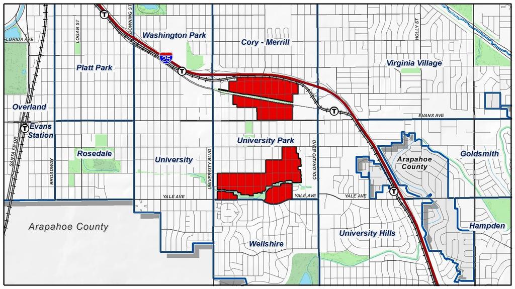
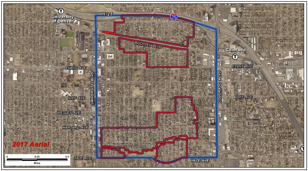
1 Community Planning and Development Planning Services W. Colfax Ave., Dept. Denver, CO 0 p:.. f:..0 TO: Denver Planning Board FROM: Chandler Van Schaack, Senior City Planner DATE: March, RE: Official Zoning Map Amendment Legislative Proposal #I-00 Staff Report and Recommendation Based on the criteria for review in the Denver Zoning Code, Staff recommends approval for legislative rezoning proposal #I-00. Legislative Request for Rezoning Address: All properties within the University Park statistical neighborhood currently zoned E-SU-Dx (see legal description) Neighborhood/Council District: University Park / Council District RNOs: Inter-Neighborhood Cooperation (INC), Southside Unified, University Park Community Council Area of Property: Approximately acres Current Zoning: E-SU-Dx Proposed Zoning: E-SU-D Property Owner(s): Various, see application Owner Representative: Paul Kashmann Summary of Rezoning Request The subject area consists of,0 properties located in the University Park statistical neighborhood, generally split between a large group of properties on the north and a large group of properties on the south side of the neighborhood. The southern properties are generally bounded by Jackson St. and University Blvd. to the east and west, and Iliff Ave. and Yale Ave. to the north and south, respectively. The northern properties are generally bounded by Garfield St. and Columbine St. to the east and west, and Interstate and Evans Ave. to the north and south, respectively. The subject area consists primarily of single unit dwellings with a few multi-unit structures in the northern area. The majority of lots are between,000 and,000 sq. ft. in size. Councilman Paul Kashmann is requesting the rezoning to remove the suburban house building form from the allowable building forms in order to address concerns raised by the University Park Community Council regarding potential impacts to privacy and solar access. The proposed E-SU-D (Urban Edge Neighborhood Context, Single Unit,.-story maximum height) zone district is a single unit district allowing only the urban house building form with a minimum zone lot area of,000 square feet. Further details of the zone districts can be found in Article of the Denver Zoning Code (DZC). Under the current E-SU-Dx zoning, which is a single unit district with a,000 square foot minimum lot size, there are two primary building forms allowed: suburban house and urban house. The primary difference between these two building forms in this context is that the
2 Page suburban house form is allowed to go up to. stories or 0 feet in height for the entire length of the building, with a 0-foot vertical bulk plane height at the side interior and side street zone lot lines and a ⁰ bulk plane slope from those lot lines (See image below for Suburban House bulk plane) Suburban House Bulk Plane Diagram By contrast, the urban house is allowed to have. stories or 0 feet in height for the front % of the lot depth and must then step down to one story or feet for the rear % of the lot depth, with a -foot vertical bulk plane height at the side interior and side street zone lot lines for the front % of the lot and a 0-foot vertical bulk plane height at the side interior and side street zone lot lines for the rear % of the zone lot depth, with a ⁰ bulk plane slope from those lot lines (See image below for Urban House bulk plane)

3 Page Urban House Bulk Plane Diagram Under the proposed zoning, E-SU-D, which is also a single unit district with a,000 square foot minimum lot size, only the urban house form would be allowed. Councilman Kashmann and the UPCC are pursuing this outcome due to concerns expressed by University Park residents that the Suburban House building form creates privacy concerns, blocks solar access in certain rear yards, and negatively impacts existing neighborhood character, because it is inconsistent with the predominant form of houses, which more closely conform to the Urban House building form.
4 Page
5 Page Existing Context The subject properties are in a residential neighborhood composed of predominantly single-unit uses with a few two-unit and religious assembly uses in the northern area. There are a variety of multi-unit residential uses located along Colorado Blvd. and University Blvd., to the east and west of the rezoning area, respectively. The University of Denver is located just across University Blvd to the west. Portions of the east side of the rezoning area are located within ½ mile of the Colorado Light Rail Station, and roughly one block of the northwestern portion of the rezone area is within ½ mile of the University of Denver Station. The following table summarizes the existing context proximate to the subject site: Site South of Buchtel Blvd., North of Harvard Ave. South East West Existing Zoning E-SU-Dx U-SU-C S-SU-D, S-SU-F, R-X G-MU-, PUD, S-SU-D, variety of Suburban commercial, mixed use and multi-unit zones G-MU- to -, CMP-EI UO- Existing Land Use Single- and twounit residential; religious assembly Single- and Twounit residential Single- unit residential Single and multiunit residential, mixed use, commercial Multi-unit residential, mixed use, commercial, campus Existing Building Form/Scale One to.-story residential structures, context-sensitive primary street setbacks One to.-story residential structures, primary street setbacks One to.-story residential structures, primary street setbacks Colorado Blvd.: mix of residential, service, office and retail; to stories; varied setbacks University Blvd: mix of residential, mixed use, commercial uses, to story buildings, varied setbacks Existing Block, Lot, Street Pattern Generally regular grid of streets. Block sizes and shapes are consistent and rectangular. Alleys are of mixed presence and sidewalks are often attached to the street. Vehicle parking to the rear of buildings (alley access) and on-street.

6 Page. Existing Zoning The current E-SU-Dx zone district is a single-unit residential district in the Urban Edge Neighborhood context. It allows suburban and urban houses with a minimum zone lot area of,000 square feet. Allowed accessory building forms are the detached garage and other detached accessory structures building forms. The maximum allowed height for primary structures is 0 to feet, and setback requirements are to 0 feet for the sides and to feet for the rear. The maximum building coverage per zone lot is.%. Primary street setbacks are block sensitive, depending on the setbacks of nearby structures. There is no minimum parking requirement for single-unit residential uses. Detached accessory garages and other structures are allowed and may be up to feet tall, must be located at least 0 feet behind the primary street facing façade of the primary structure, set back 0 to feet on the sides and rear, and cannot be larger than,000 square feet. For additional details of the zone district, see DZC Article. Existing Zoning: E-SU-Dx Proposed Zoning: E-SU-D Applicable Building Forms Suburban House Urban House Detached Garage Detached Accessory Structures X X X X X X X


7 Page. Land Use Map. Existing Building Form and Scale (images from Google Maps) View of properties on Cook St. north of Jewell Ave.


8 Page View of properties on Adams St. north of Evans Ave. View of properties on Adams St. south of Wesley Ave.


9 Page View of properties on Adams St. north of Yale Ave. View of properties on Clayton St. north of Vassar Ave. Summary of City Agency Referral Comments As part of the DZC review process, the rezoning application is referred to potentially affected city agencies and departments for comment. A summary of agency referral responses follows: Assessor: Approved No Response Asset Management: Approved Response Denver Public Schools: Approved No Response Denver Department of Public Health and Environment: Approved - See Comments Below
10 Page 0 Notes. The Denver Department of Public Health and Environment (DDPHE) is aware of isolated environmental concerns in the project area that should be evaluated during future development of individual projects; DDPHE concurs with the rezoning request. General Notes: Most of Colorado is high risk for radon, a naturally occurring radioactive gas. Due to concern for potential radon gas intrusion into buildings, DEH suggests installation of a radon mitigation system in structures planned for human occupation or frequent use. It may be more cost effective to install a radon system during new construction rather than after construction is complete. Denver s Noise Ordinance (Chapter Noise Control, Denver Revised Municipal Code) identifies allowable levels of noise. Properties undergoing Re-Zoning may change the acoustic environment, but must maintain compliance with the Noise Ordinance. Compliance with the Noise Ordinance is based on the status of the receptor property (for example, adjacent Residential receptors), and not the status of the noise-generating property. Violations of the Noise Ordinance commonly result from, but are not limited to, the operation or improper placement of HV/AC units, generators, and loading docks. Construction noise is exempted from the Noise Ordinance during the following hours, am pm (Mon Fri) and am pm (Sat & Sun). Variances for nighttime work are allowed, but the variance approval process requires to months. For variance requests or questions related to the Noise Ordinance, please contact Paul Riedesel, Denver Environmental Health (--0). Scope & Limitations: DEH performed a limited search for information known to DEH regarding environmental conditions at the subject site. This review was not intended to conform to ASTM standard practice for Phase I site assessments, nor was it designed to identify all potential environmental conditions. In addition, the review was not intended to assess environmental conditions for any potential right-of-way or easement conveyance process. The City and County of Denver provides no representations or warranties regarding the accuracy, reliability, or completeness of the information provided. Parks and Recreation: Approved No Response Public Works ROW - City Surveyor: Approved No Comments Development Services Transportation Approved See Comments below DES Transportation approves the subject zoning change. The applicant should note that redevelopment of this site may require additional engineering, ROW dedication to the City, access changes, traffic studies and/or right of way improvements. The extent of the required design and improvements will be determined once this property begins the redevelopment process. The results of any traffic studies may require the construction of off-site mitigation or may limit the proposed density of the project. Development Services Wastewater Approved See Comments Below There is no problem to the rezone, however applicant should be under notice that the Public Works will not approve any development of this property without assurance that there is sufficient sanitary and storm sewer capacity and access (easements may be necessary). A sanitary study and drainage study
11 Page may be necessary. These studies may result in a requirement for the developer to install major infrastructure improvements or a limit to development if current infrastructure is insufficient. Development Services Project Coordination: Approved No Comments Development Services Fire Prevention: Approved No Response Public Review Process CPD informational notice of receipt of the rezoning application to all affected members of City Council, registered neighborhood organizations, and property owners: Property legally posted for a period of days and CPD written notice of the Planning Board public hearing sent to all affected members of City Council, registered neighborhood organizations, and property owners: Date // // Planning Board hearing: /0/ CPD written notice of the Land Use, Transportation and Infrastructure Committee meeting sent to all affected members of City Council and registered neighborhood organizations, at least ten working days before the meeting (tentative): Land Use, Transportation and Infrastructure Committee review (tentative): TBD // Property legally posted for a period of days and CPD written notice of the City Council public hearing sent to all affected members of TBD City Council and registered neighborhood organizations (tentative): City Council Public Hearing (tentative): /0/ o o Registered Neighborhood Organizations (RNOs) The University Park Community Council has been involved in this rezoning request from the beginning, and has provided a letter of support (attached). Other Public Comment As of the date of this staff report, staff has received comments from several neighbors in support of the proposed rezoning.
12 Page o Public Outreach Staff presented information on the proposed zoning change at a UPCC general meeting on May, UPCC representatives discussed the proposed change at another general meeting on October, The UPCC worked with Councilman Kashmann s office to create an information flyer on the proposed rezoning, which was mailed to all property owners within the rezoning area on October, The UPCC, along with Councilman Kashmann and city staff, held two open houses to provide information to residents on the proposed rezoning on October and,. The UPCC created a survey on their website to gather feedback on the proposed rezoning. There were total responses, of which were in favor and of which were opposed. Additional outreach efforts included talking to individual property owners and providing additional notice of the April hearing date via the UPCC news blast. Criteria for Review / Staff Evaluation The criteria for review of this legislative rezoning request are found in DZC, Section..0. as follows: DZC Section..0.. Consistency with Adopted Plans. Uniformity of District Regulations and Restrictions. Public Health, Safety and General Welfare. Consistency with Adopted Plans The following adopted plans currently apply to this property if the rezoning is approved prior to the anticipated adoption of the Denveright plans (April, ): Denver Comprehensive Plan 00 Blueprint Denver (0) If the proposed map amendment is approved by City Council after the adoption of the Denveright plans (anticipated April, ), the following plans would apply instead: Denver Comprehensive Plan 0 Blueprint Denver () The following plan will apply to this property both before and after April, : University Park Neighborhood Plan (0) Denver Comprehensive Plan 00 The proposal is consistent with many Denver Comprehensive Plan strategies, including: Land Use Strategy -B Encourage quality infill development that is consistent with the character of the surrounding neighborhood; that offers opportunities for increased density and more amenities; and that broadens the variety of compatible uses.
13 Page Legacies Strategy -C Identify community design and development issues, and target specific concerns with appropriate controls and incentives. The proposal to rezone the subject area from E-SU-Dx to E-SU-D is consistent with the above Comprehensive Plan strategies in that it is intended to address a community design and development issue while ensuring that future infill development is consistent with the character of the surrounding neighborhood. Denver Comprehensive Plan 0 Although the Comprehensive Plan is not yet adopted, it is anticipated to be considered by City Council by the time this map amendment would be at council for public hearing and would be relevant to this request. As such, this staff report provides an analysis of the most current public draft of the plan (Planning Board Draft; March, ) and the proposed rezoning is consistent with several of the draft Denver Comprehensive Plan 0 strategies, including: Goal. Enhance Denver s neighborhoods through high quality urban design o Strategy D. Use urban design to contribute to economic viability, public health, safety, environmental well-being, neighborhood culture, and quality of life. Goal. Preserve the authenticity of Denver s neighborhoods and celebrate our history, architecture and culture The proposal to rezone the subject area from E-SU-Dx to E-SU-D is consistent with the above Comprehensive Plan 0 strategies in that it is intended to address a community design and development issue while ensuring that future infill development is consistent with the character of the surrounding neighborhood. Blueprint Denver 0 According to the 0 Plan Map adopted in Blueprint Denver, this area has a concept land use of Single Family Residential and is located in an Area of Stability.

14 Page Future Land Use Blueprint Denver describes Single Family Residential areas as those with densities fewer than 0 units per acre, often less than six units per acre neighborhood-wide, and an employment base significantly smaller than the housing base with single family homes as the predominant residential type. The existing land use in the area proposed for rezoning is comprised almost entirely of single family residential uses, with a small number of zone lots containing small-scale multi-unit residential or religious assembly uses. Overall, the area is consistent with the concept land use description, and would remain consistent following the proposed rezoning to E-SU-D, which is still a single family zone district with the same overall allowable density and land uses. Area of Change / Area of Stability The subject site is located in an Area of Stability. The goal for Areas of Stability is to maintain the character of an area while accommodating some new development and redevelopment at appropriate locations (p. ). In terms of the area character, the University Park neighborhood is comprised almost exclusively of single unit residential uses. The proposed rezoning from E-SU-Dx to E-SU-D would maintain the area character in that it would remain a single unit zone district with the same minimum lot size requirements while removing the suburban house building form, which has been identified by area residents as being out of character with existing development. As most buildings appear to be constructed nearer to the front of the lot and suburban house-style houses are not common, staff agrees that the urban house building form is more typical of this area and will better promote stability in character and form Street Classifications The area proposed for rezoning includes primarily undesignated local streets as well as residential collectors and a mixed-use arterial. The northern area is bounded by I- on the north, and is
15 Page intersected by two collector streets, S. Saint Paul St. and Buchtel Ave., with Evans Ave., a Mixed Use Arterial, forming the southern boundary. The southern area is bounded by two residential collectors: Iliff Ave. to the north and Yale Ave. to the south. In both areas, local access is provided by undesignated local streets, with the collector and/or arterial streets providing connections through the neighborhood to the surrounding area. Blueprint Denver states the design features of local streets are influenced less by traffic volumes and are tailored more to providing local access. Mobility on local streets is typically incidental and involves relatively short trips at lower speeds to and from other streets (p. ). Anticipated traffic volumes on local streets are less than,000 vehicles per day. Blueprint Denver states collectors are designed to provide a greater balance between mobility and land access within residential, commercial and industrial areas. The makeup of a collector street largely depends on the density, size and type of nearby buildings (p. ). Given that the proposed rezoning would not affect the overall development potential of the area in terms of density or intensity of uses, there would be no notable impact to the existing streets. Since the neighborhood is well-served by arterial and collector streets, with local access provided by an established grid of local streets, the proposed rezoning would remain consistent with the street classifications for the area. Blueprint Denver () Although not yet adopted by City Council, Blueprint Denver is anticipated to be adopted by City Council by the time this map amendment will be at council for public hearing, therefore it is relevant to this request. The proposed rezoning was reviewed for consistency with the March,, Planning Board Draft of Blueprint Denver (). The draft Blueprint Denver identifies the subject property as part of a Residential Low place within the Urban Edge Context and provides guidance from the future growth strategy for the city.

16 Page Future Neighborhood Context The subject area is within the Urban Edge Neighborhood Context. The urban edge context areas are predominately residential and tend to act as a transition between urban and suburban areas. Homes in this context are typically low-scale single- and two-unit residential with some small scale multi-unit residential. Commercial and mixed-use development in this context tends to be found along the main corridors bordering traditional residential areas, with some larger center development (p. ). The proposed E-SU-D zone district is part of the Urban Edge context and is intended to promote and protect residential neighborhoods within the character of the Urban Edge Neighborhood Context [and] to reinforce desired development patterns in existing neighborhoods while accommodating reinvestment (DZC...). Given that the proposed E-SU-D zone district would maintain the predominately low-scale single unit residential character of the area, the proposed rezoning is appropriate and consistent with the neighborhood context recommended by the plan.
17 Page Future Places The Future Places map shows the subject area as Residential Low. Blueprint Denver describes the aspirational characteristics of the Residential Low areas in the Urban Edge context as Predominately single- and two-unit uses on small or medium lots [with] low to medium building coverage. Buildings are generally up to. stories in height (p. ). The proposed E-SU-D zone district is consistent with the Residential Low place type in that it maintains the existing,000 square foot minimum zone lot size while allowing for.% total building coverage and. stories in height for urban houses.

18 Page Street Types The majority of streets within the proposed rezoning area are classified in Blueprint Denver as undesignated or local streets, which are most often characterized by residential uses [and] provide the lowest degree of through travel but the highest degree of property access. Yale Ave. and Evans Ave. are classified as Residential Arterials, which are designed for the highest amount of through movement and the lowest degree of property access (p. ). Saint Paul St., Buchtel Blvd., and Iliff Ave. are all classified as Residential Collectors, which are in between a local street and an arterial street; they collect movement from local streets and convey it to arterial streets. The proposed E-SU-D zone district is consistent with these street classifications, as it allows only single unit residential uses and would not significantly alter the existing traffic patterns.

19 Page Growth Strategy The subject area is part of All other areas of the city within the Blueprint Denver Future Growth Areas map. These areas, mostly residential areas with embedded local centers and corridors, take a smaller amount of growth intended to strengthen the existing character of our neighborhoods (p. ) and are anticipated to see around 0% of new job growth and % of new housing growth by the year 0. The proposed E-SU-D zone district is consistent with the growth strategy for the area, as it maintains the existing growth potential for the area while strengthening the character of the neighborhood as envisioned by local residents. University Park Neighborhood Plan (0) The stated vision of the University Park Neighborhood Plan is To perpetuate and enhance the integrity of the University Park neighborhood, with the overriding theme of the plan being to create and nurture a community that accommodates a wide variety of uses and people in an environment that enhances the quality of life for residents and the vitality of businesses. The plan largely promotes maintaining and strengthening the existing single family residential character, and includes a recommendation to create a greater sense of certainty and trust among the neighborhood, the development community and the city in terms of new development and redevelopment. (p. ) The Urban Design & Land Use section of the plan states: University Park has always been home to a variety of architectural styles, but there is concern that these new homes are not consistent with the overall neighborhood fabric in terms of open space, tree canopy, lot coverage/building orientation (i.e. amount of the lot occupied by building(s) and their placement on the lot), building mass (i.e. the perceived size of buildings) and building heights. These concerns are further reflected in Urban Design & Land Use Goal, Residential Neighborhood Character Stability, which states: Preserve the single-


20 Page family nature of University Park s residential neighborhood, and respect the urban design and the architectural character of established and preferred residential forms. Regarding intended future land use, the Plan includes a Concept Land Use map based on four urban design districts. The entire area included in the proposed rezoning is shown on this map as Single Family Residential Neighborhood, as shown below (rezoning area boundaries, shown in red, are approximate): University Park Neighborhood Plan Concept Areas Map (P. ) As mentioned in the letter from Councilman Kashmann, this request is based on a robust public outreach process wherein residents largely agreed that the suburban house form is an undesirable building form for the area, both in terms of its impacts to privacy and solar access as well as its incompatibility with the existing architectural character of the area. The proposed rezoning from E-SU- Dx to E-SU-D is consistent with the goals of the University Park Neighborhood Plan in that it would maintain the existing single family residential character of the area while also reducing perceived impacts associated with the suburban house building form.
21 Page. Uniformity of District Regulations and Restrictions The proposed map amendment would rezone all properties within University Park currently zoned E-SU- Dx to E-SU-D, and would thus result in uniform regulations across the area. No waivers or conditions are requested.. Public Health, Safety and General Welfare University Park residents have been concerned that the Suburban House building form creates privacy concerns, blocks solar access in certain rear yards, and negatively impacts existing neighborhood character, because it is inconsistent with the predominant form of houses, which more closely conform to the Urban House building form. Therefore, in addition to furthering the public health and safety by implementing the City s adopted plans, the proposed rezoning also furthers the general welfare of University Park residents by removing a building form that they have identified as being problematic while protecting the overall single family residential character of the neighborhood. Attachments. Rezoning Proposal. Letters of support

: Assessor s Parcel Numbers: Area in Acres or Square Feet: Current Zone Districts: PROPOSAL Proposed Zone Districts: All")
22 COMMUNITY PLANNING & DEVELOPMENT REZONING GUIDE Proposal Page of Zone Map Amendment (Rezoning) - Legislative Rezoning Proposal PROPERTY OWNER INFORMATION REPRESENTATIVE* Property Owner Name Multiple owners Representative Name Councilman Paul Kashmann - legislative rezoning Address Address Bannock Street, # City, State, Zip City, State, Zip Denver, CO 0 Telephone Telephone -- paul.kashmann@denvergov.org SUBJECT PROPERTY INFORMATION Location (address and/or boundary description): Assessor s Parcel Numbers: Area in Acres or Square Feet: Current Zone Districts: PROPOSAL Proposed Zone Districts: All properties zoned E-SU-Dx located in the University Park Neighborhood between I- and Harvard Gulch. See attached exhibits and legal descriptions. Multiple Approximately. acres E-SU-Dx E-SU-D REVIEW CRITERIA General Review Criteria: The proposal must comply with all of the general review criteria DZC Sec...0. Consistency with Adopted Plans: The proposed official map amendment is consistent with the City s adopted plans, or the proposed rezoning is necessary to provide land for a community need that was not anticipated at the time of adoption of the City s Plan Please provide an attachment describing relevant adopted plans and how proposed map amendment is consistent with those plan recommendations; or, describe how the map amendment is necessary to provide for an unanticipated community need. Uniformity of District Regulations and Restrictions: The proposed official map amendment results in regulations and restrictions that are uniform for each kind of building throughout each district having the same classification and bearing the same symbol or designation on the official map, but the regulations in one district may differ from those in other districts. Public Health, Safety and General Welfare: The proposed official map amendment furthers the public health, safety, and general welfare of the City. Last updated: June, Return completed form to rezoning@denvergov.org W. Colfax Ave., Dept. Denver, CO 0 -- rezoning@denvergov.org


23 The Honorable Paul Kashmann Councilman District Chandler VanSchaack Community Planning and Development City and County of Denver City Council City and County Building Bannock Street, Room Denver, CO 0 p:.. paul.kashmann@denvergov.org Dear Chandler, As Councilman for District, I am requesting that Community Planning and Development prepare a legislative map amendment that would eliminate the option to construct the suburban long house form for the properties shown within the yellow boundaries on the map below. As you know the suburban form allows for two-story construction from front to back on a lot, while the urban form limits two-stories to the front % percent of the lot. The motivation for this change is to maximize privacy and solar access in back yards throughout the rezoning area. This proposal is the result of a robust community engagement process that included mailings to every property owner in the area to be considered, as well as two public meetings held in the District to answer any questions and an on-line survey designed to collect property-owner concerns. The only negative issue I have heard from residents has been a concern that by eliminating the suburban house form in favor of the urban form CPD would be limiting the square footage that could be built on a parcel. It turns out that modeling indicates the urban house form actually allows for more square feet due to the second story setbacks that bulk plane restrictions force on second story construction in the suburban form. I ask for your support of this legislative rezoning that I am putting forward. Regards, Paul Paul Kashmann Denver City Council, District --0 E-SU-Dx Dx is a zone district that allows both the Suburban LONG House and Urban House building forms. E-SU-D D is a zone district that allows the Urban House building forms but prohibits the Suburban LONG House.

24 E-SU-Dx Zone Districts Outlined in Yellow BUCH EVANS AVE EVANS AVE COLORADO BLVD UNIVERSITY BLVD TEL BL VD ILIFF AVE HARVARD AVE YALE AVE YALE AVE
25 Zone Map Amendment i-00 DRAFT Legal Description A part of Sections,, and, Township South, Range West of the Sixth Principal Meridian, City and County of Denver, State of Colorado. That the zoning classification of the area in the City and County of Denver described as follows or included within the following boundaries shall be and hereby is changed from E-SU-DX to E-SU-D (Area North of Evans Ave. See Exhibit A) COLUMBIA PARK SUBDIVISION OF BLOCK MAPLEWOOD SUBDIVISION Block, Lots to 0 CORNELL PARK SUBDIVISION OF BLOCK MAPLEWOOD SUBDIVISION Block, Lots to DOUGLAS PARK BEING A SUBDIVISION OF BLOCK MAPLEWOOD SUBDIVISION Block, Lots to FIRST ADDITION TO UNIVERSITY PARK Block, The portion of Lot 0 Defined in RCP #00 //0 Blocks to, Lots to Block, Lots to Block, Lots to Block, Lots to Block 0, Lots to And that portion of Vacated Jewell Ave. Adjoining Lot Block 0, Lots to Block, Lots to and Lots to Block, Lots to HARVARD PARK SUBDIVISION OF BLOCK MAPLEWOOD SUBDIVISION Block, Lots to Observatory Terrace Subdivision Filing No. Block, Lots to and Tract A RESUBDIVISION OF LOT MAPLEWOOD SUBDIVISION Block, Lots to SCOTT PARK SUBDIVISION OF BLOCK 0 MAPLEWOOD Block 0, Lots to
26 University Park Amended Map Block, Lots to Block, Lots to Block, Lots to Block, Lot, and Lots to, and Lots to Block 0, Lots to, and Lots to, and lots to Block, Lots to, and Lots to, and Lots to Block, Lots to 0, and Lots to, and Lots to Block, Lots to, and Lots to, and Lots 0 to Block, Lots to Block, Lots to Block, Lots to Block, Lots to Block, Lots to WEAVER PARK SUBDIVISION OF BLOCK MAPLEWOOD Block, Lots to YALE PARK SUBDIVISION OF BLOCK MAPLEWOOD Block, Lots to (Area South of Iliff Ave. See Exhibit B) ARAPAHOE GARDENS Block, Lots to Block, Lots to ASBURY PARK Block, Lots to Block, Lots to, and Lots to Block, Lots to Block, That part of the East ' of Lot, South of a line extending from a point ' South of the Northeasterly corner of Lot to a point ' North of the Southwesterly corner of said Lot Block Block, The East of Lots to Block, Lots to, and Lots to Block, Lots to, Block, That part of Lot, South of a line extending from a point.' East of the Northwesterly corner of Lot to a point ' South of the Northeasterly corner of said Lot Block, Lots to and Lots to Block, Lots to Block, Lots to And that portion of Vacated Yale Ave. Adjoining Lot Block, Lots to
27 Block, Lots to And that portion of Vacated Yale Ave. Adjoining Lot Block, Lots to Block, That part of Lots to 0, Southeast of a line extending from the Northeast corner of Lot to the Southwest corner of Lot 0 Block, Lots to And that portion of Vacated Yale Ave. Adjoining Lot Block, Lots to ASBURY PARK ND FILING Block, Lots to Block 0, Lots to Block, Lots to Block, Lots to Block, Lots to Block, Lots to And all of Vacated College Place Adjacent to Block and FIRST ADDITION TO UNIVERSITY GARDENS Block, The West ' of the South.' of the East 00' Block, The West 0' of the South ' of the East 00' excluding the South.' Block, The West ' of the South.' of the East 00' excluding the South ' Block, The West 0.' of the North.' of the East 00' Block, The West ' of the North 0' Block, The West ' of the East 00' of the north 0' Iliff's University Addition Block, Lots to Block, Lots to Block, Lots to Block, Lots to Block, Lots to Block, Lots to Block, Lots to Block, Lots to and Lots to Block, Lots to Block, Lots to, Excluding part of Lot Beginning at the Northeast corner then South ' then Northwesterly to a point ' West of the Northeast corner then East to the POB Block, Lots to, Excluding part of Lot Beginning at the Northwest corner then Southeasterly to a point 0' of the East of the Southwest corner then West 0' then North to the POB Block, Lots to, and Lots to Block, North 0' of Lot and Lots to Block, Lots to, and Lots to Block, Lots to, and Lots to Block, Lots to, and Lots to
28 Block, Lots to, Excluding parts of Lots and Beginning at the Southeast corner of Lot then North to the Northeast corner of Lot then Southwesterly to a point 0' west of the Southeast corner of Lot then East to the POB SHAKESPEAR ADDITION TO DENVER COLORADO Block, Lots to Block, Lots to UNIVERSITY GARDENS Block, The West.' appx Block, The West / and the West 00' of the South.' of the East / Block, The South 0.' of the West ' Block, The West ' of the East 00' of the North ' Block, The West ' of the East 00' of the South 00' Block, The West 0.' of the South.' of the East 00' Block, The West ' of the South ' of the East 00' excluding the South.' WELLSHIRE HILLS FILING NO Block, Lots to Block, Lots to Block, Lots to All Vacated Street or Alley Rights of Way lying adjacent to described areas. In addition thereto those portions of all abutting public rights-of-way, but only to the centerline thereof, which are immediately adjacent to the aforesaid specifically described area.
29 University Park - Amended Map First Addition To University Park Scott Park YALE PARK Cornell Park Weaver Park Harvard Park Douglas Park Columbia Park ResubLot Maplewood Sub Observatory Terrace Sub Filing No. University Park - Amended Map ASBURY AVE BUCHTEL BLVD JEWELL AVE CLAYTON ST SAINT PAUL ST JOSEPHINE ST COLUMBINE ST EVANS AVE FILLMORE ST MADISON ST ADAMS ST COOK ST STEELE ST MILWAUKEE ST INTERSTATE JEWELL AVE FILLMORE ST MADISON ST ADAMS ST COOK ST MILWAUKEE ST COLORADO AVE MONROE ST Tract A November EXHIBIT A Zone Map Amendment i-00! Feet University Park Statistical Neighborhood Area to be changed from Zone District E-SU-Dx To E-SU-D
30 ILIFF AVE VASSAR AVE COOK ST WESLEY AVE HARVARD AVE ADAMS ST YALE AVE MONROE ST MADISON ST JOSEPHINE ST FILLMORE ST CLAYTON ST COLUMBINE ST MILWAUKEE ST SAINT PAUL ST STEELE ST GARFIELD ST YALE AVE Iliff's University Addition Asbury Park University Gardens Asbury Park, Second Filing First Addition to University Gardens Wellshire Hills, Filing No. ARAPAHOE GARDENS Shakespear Addition Iliff's University Addition Asbury Park C 0 A November EXHIBIT B Zone Map Amendment i-00! Feet University Park Statistical Neighborhood Area to be changed from Zone District E-SU-Dx To E-SU-D
31 A. Consistency with Adopted Plans The proposed official map amendment is consistent with the City s adopted plans, or the proposed rezoning is necessary to provide land for a community need that was not anticipated at the time of the adoption of the City's plan. There are three adopted plans that apply to the subject area: Comprehensive Plan 00, Blueprint Denver and The University Park Neighborhood Plan (0). Consistency with each of these plans is discussed below. Comprehensive Plan 00 Land Use Strategy -B Encourage quality infill development that is consistent with the character of the surrounding neighborhood; that offers opportunities for increased density and more amenities; and that broadens the variety of compatible uses. Legacies Strategy -C Identify community design and development issues, and target specific concerns with appropriate controls and incentives. The proposal to rezone the subject area from E-SU-Dx to E-SU-D is consistent with the above Comprehensive Plan strategies in that it is intended to address a community design and development issue while ensuring that future infill development is consistent with the character if the surrounding neighborhood. Blueprint Denver (0) According to Blueprint Denver, the area proposed to be rezoned has a concept land use of Single Family Residential and is located in an Area of Stability. Future Land Use Blueprint Denver describes Single Family Residential areas as those with densities fewer than 0 units per acre, often less than six units per acre neighborhood-wide, and an employment base significantly smaller than the housing base with single family homes as the predominant residential type. The existing land use in the area proposed for rezoning is comprised almost entirely of single family residential uses, with a small number of zone lots (0), containing smallscale multi-unit residential uses. Overall, the area is consistent with the concept land use description, and would remain consistent following the proposed rezoning to E-SU-D, which is still a single family zone district with the same overall allowable density and land uses. Area of Change/ Area of Stability The subject site is located in an Area of Stability. The goal for Areas of Stability is to maintain the character of an area while accommodating some new development and redevelopment at appropriate locations (p. ). In terms of the area character, the University Park neighborhood is comprised almost exclusively of single family residential uses. The proposed rezoning from E- SU-Dx to E-SU-D would maintain the area character in that it would remain a single family zone
32 district with the same minimum lot size requirements while removing the suburban house building form, which has been identified by area residents as being out of character with existing development. Street Classifications The area proposed for rezoning includes undesignated primarily local streets as well as residential collectors and a mixed use arterial. The northern area is bounded by I- on the north, and is intersected by two collector streets, S. Saint Paul St. and Buchtel Ave., with Evans Ave., a Mixed Use Arterial, forming the southern boundary. The southern area is bounded by two residential collectors: Iliff Ave to the north and Yale Ave to the south. In both areas, local access is provided by undesignated local streets, with the collector and/or arterial streets providing connections through the neighborhood to the surrounding area. Blueprint Denver states the design features of local streets are influenced less by traffic volumes and are tailored more to providing local access. Mobility on local streets is typically incidental and involves relatively short trips at lower speeds to and from other streets (p. ). Anticipated traffic volumes on local streets are less than,000 vehicles per day. Blueprint Denver states collectors are designed to provide a greater balance between mobility and land access within residential, commercial and industrial areas. The makeup of a collector street largely depends on the density, size and type of nearby buildings (p. ). Given that the proposed rezoning would not affect the overall development potential of the area in terms of density or intensity of uses, there would be no notable impact to the existing streets. Since the neighborhood is well-served by arterial and collector streets, with local access provided by an established grid of local streets, the proposed rezoning would remain consistent with the street classifications for the area. University Park Neighborhood Plan (0) The stated vision of the University Park Neighborhood Plan is To perpetuate and enhance the integrity of the University Park neighborhood, with the overriding theme of the plan being to create and nurture a community that accommodates a wide variety of uses and people in an environment that enhances the quality of life for residents and the vitality of businesses. The plan largely promotes maintaining and strengthening the existing single family residential character, and includes a recommendation to create a greater sense of certainty and trust among the neighborhood, the development community and the city in terms of new development and redevelopment. (P. ) The Urban Design & Land Use section of the plan states: University Park has always been home to a variety of architectural styles, but there is concern that these new homes are not consistent with the overall neighborhood fabric in terms of open space, tree canopy, lot coverage/building orientation (i.e. amount of the lot occupied by building(s) and their placement on the lot), building mass (i.e. the perceived size of buildings) and building heights. These concerns are further reflected in Urban Design & Land Use Goal, Residential Neighborhood Character Stability, which states: Preserve the single-family nature of University Park s residential

33 neighborhood, and respect the urban design and the architectural character of established and preferred residential forms. Regarding intended future land use, the Plan includes a Concept Land Use map based on four urban design districts. The entire area included in the proposed rezoning is shown on this map as Single Family Residential Neighborhood, as shown below (rezoning area boundaries, shown in red, are approximate): University Park Neighborhood Plan Concept Areas Map (P. ) As mentioned in the letter from Councilman Kashmann, this request is based on a robust public outreach process wherein residents largely agreed that the suburban house form is an undesirable building form for the area, both in terms of its impacts to privacy and solar access as well as its incompatibility with the existing architectural character of the area. The proposed rezoning from E-SU-Dx to E-SU-D is consistent with the goals of the University Park Neighborhood Plan in that it would maintain the existing single family residential character of the area while also reducing perceived impacts associated with the suburban house building form. B. Uniformity of District Regulations and Restrictions The proposed official map amendment results in regulations and restrictions that are uniform for each kind of building throughout each district having the same classification and bearing
34 the same symbol or designation on the official map, but the regulations in one district may differ from those in other districts. The proposed map amendment would rezone all properties within University Park currently zoned E-SU-Dx to E-SU-D, and would thus result in uniform regulations across the area. No waivers or conditions are requested. C. Public Health, Safety and General Welfare The proposed official map amendment furthers the public health, safety and general welfare of the City. As mentioned above, this rezoning request is based on extensive public outreach within the University Park Neighborhood. The request is sponsored by Councilman Paul Kashmann and has been endorsed by the University Park Community Council. The request to X the x, as it has become known, came as a result of various neighbors expressing concerns with the Suburban House building form, which is allowed by the E-SU-Dx zone district. Specifically, University Park residents complained that the Suburban House building form was creating privacy concerns, blocking solar access in certain rear yards, and negatively impacting existing neighborhood character. Therefore, in addition to furthering the public health and safety by implementing the City s adopted plans, the proposed rezoning also furthers the general welfare of University Park residents by removing a building form that they have identified as being problematic while protecting the overall single family residential character of the neighborhood.
35 Mar., Dear Members of Planning Board, University Park Community Council (UPCC) urges Planning Board to support the request by Councilman Paul Kashmann and the University Park Registered Neighborhood Association to rezone all E-SU-Dx zone districts in University Park to E-SU-D. We were alarmed when we became aware that several new long houses had been constructed in our neighborhood. Our intent is to prevent more from being built. The long house name applies to two story homes which extend the full depth of the buildable area, blocking privacy and a feeling of open space to adjacent homes. The Quick Wins II zoning ordinance, adopted in 0, eliminated the long house option until 0, when the Zoning Code was updated in a massive overhaul throughout the entire city. Now, in areas zoned E-SU-Dx in University Park, homes can be built using either the Urban House form or the Suburban House form. Although we actively participated in the update process, we and CPD overlooked the possibility that this could be a way to re-create the long house in our neighborhood. Although both house forms provide similar square footage potential, the Urban House form restricts two story development to the front % of the lot and requires a step-down to one story on the rear % of the lot. The Suburban House form doesn t have this restriction and allows two stories to extend the full depth of the buildable area. UPCC sent information packets to every property owner in all E-SU-Dx zone districts to inform them about UPCC s request. We included a link to a survey on our web site for property owners to tell us if they agreed or disagreed with our proposal. We received responses, in favor, two not in favor. This proposal was discussed at several neighborhood general meetings with presentations by Councilman Kashmann and city staff. Councilman Kashmann and city staff also held two open houses about the proposal, and no opposition was voiced. UPCC hopes Planning Board members agree with this proposed rezoning to remove the Suburban House form option, and therefore eliminate the possibility of additional long houses in our neighborhood. We are very grateful to Councilman Paul Kashmann for supporting this through a legislative rezoning. Sincerely, Debbie Harrington, UPCC President Pat Cashen, UPCC Zoning Chair Rosemary Stoffel, UPCC Community Preservation Chair
Staff Report and Recommendation
 Community Planning and Development Planning Services 201 W. Colfax Ave., Dept. 205 Denver, CO 80202 p: 720.865.2915 f: 720.865.3052 www.denvergov.org/cpd TO: City Council Neighborhoods and Planning Committee
Staff Report and Recommendation Based on the criteria for review in the Denver Zoning Code, Staff recommends approval for Application #2017I
 TO: Denver City Council Land Use, Transportation and Infrastructure Committee FROM: Theresa Lucero, Senior City Planner DATE: RE: Official Zoning Map Amendment Application #2017I-00149 Staff Report and
Official Zoning Map Amendment Application #2018I-00047
 Community Planning and Development Planning Services 201 W. Colfax Ave., Dept. 205 Denver, CO 80202 p: 720.865.2915 f: 720.865.3052 www.denvergov.org/cpd TO: Denver Planning Board FROM: Chandler Van Schaack,
Official Zoning Map Amendment Application #2018I-00077
 Community Planning and Development Planning Services 201 W. Colfax Ave., Dept. 205 Denver, CO 80202 p: 720.865.2915 f: 720.865.3052 www.denvergov.org/cpd TO: Denver Planning Board FROM: Scott Robinson,
Denver Land Use, Transportation and Infrastructure Committee FROM: Andrew Webb, Senior City Planner DATE: March 22, 2018 RE:
 Community Planning and Development Planning Services 201 W. Colfax Ave., Dept. 205 Denver, CO 80202 p: 720.865.2915 f: 720.865.3052 www.denvergov.org/cpd TO: Denver Land Use, Transportation and Infrastructure
Staff Report and Recommendation Based on the criteria for review in the Denver Zoning Code, Staff recommends approval for Application #2018I
 Community Planning and Development Planning Services 201 W. Colfax Ave., Dept. 205 Denver, CO 80202 p: 720.865.2915 f: 720.865.3052 www.denvergov.org/cpd TO: Denver Planning Board FROM: Sara White, AICP,
Planning Services Community Planning and Development 201 W. Colfax Ave., Dept. 205 Denver, CO p
 TO: Denver Planning Board, Julie Underdahl, Chair FROM: Theresa Lucero, Senior City Planner DATE: RE: Official Zoning Map Amendment Application #2017I-00042 Staff Report and Recommendation Based on the
To: S-MX-8 AIO, S-MX-8A AIO, S-MX-12 AIO, C-MX-8 AIO, C-MX-12 AIO, and S-CC-5 AIO
 Community Planning and Development Planning Services 201 W. Colfax Ave., Dept. 205 Denver, CO 80202 p: 720.865.2915 f: 720.865.3052 www.denvergov.org/cpd TO: City Council Neighborhoods and Planning Committee
2 nd & St Paul, LLC and BAH-PLA, LLC
 Community Planning and Development Planning Services 201 W. Colfax Ave., Dept. 205 Denver, CO 80202 p: 720.865.2915 f: 720.865.3052 www.denvergov.org/cpd TO: Denver City Council FROM: Theresa Lucero, Senior
TO: Denver Planning Board FROM: Analiese Hock, Senior City Planner DATE: March 13, 2018 RE:
 Community Planning and Development Planning Services 201 W. Colfax Ave., Dept. 205 Denver, CO 80202 p: 720.865.2915 f: 720.865.3052 www.denvergov.org/cpd TO: Denver Planning Board FROM: Analiese Hock,
REZONING GUIDE. Zone Map Amendment (Rezoning) - Application. Rezoning Application Page 1 of 3. Return completed form to
 - Application. Rezoning Application Page 1 of 3. Return completed form to") Zone Map Amendment (Rezoning) - Application COMMUNITY PLANNING & DEVELOPMENT REZONING GUIDE Rezoning Application Page 1 of 3 PROPERTY OWNER INFORMATION* CHECK IF POINT OF CONTACT FOR APPLICATION Property
Zone Map Amendment (Rezoning) - Application COMMUNITY PLANNING & DEVELOPMENT REZONING GUIDE Rezoning Application Page 1 of 3 PROPERTY OWNER INFORMATION* CHECK IF POINT OF CONTACT FOR APPLICATION Property
September 25th, 2018 $2000 fee pd CC
 2.7267 acres 2018I-00075 September 25th, 2018 $2000 fee pd CC Rezoning Review Criteria Analysis - Map Amendment Application Number: 2018I-00075 805 W. 38 th Avenue October 19, 2018 (amd.) September 17,
Official Zoning Map Amendment Application #2018I-00075
 Community Planning and Development Planning Services 201 W. Colfax Ave., Dept. 205 Denver, CO 80202 p: 720.865.2915 f: 720.865.3052 www.denvergov.org/cpd TO: Denver Planning Board FROM: Scott Robinson,
, C-MS I June 3, 2016 $1500 pd chk #216918
 , C-MS-8 LOTS 21 THROUGH 40, INCLUSIVE, BLOCK 299 CLEMENTS ADDITION TO THE CITY OF DENVER SOUTHEAST QUARTER OF SECTION 34, TOWNSHIP 3 SOUTH, RANGE 68 WEST, SIXTH PRINCIPAL MERIDIAN, CITY
Staff Report and Recommendation
 Community Planning and Development Planning Services 201 W Colfax Ave, Dept 205 Denver, CO 80202 p: 720-865-2972 f: 720-865-3056 www.denvergov.org/planning TO: LUTI FROM: Steve Nalley, Senior City Planner
REZONING GUIDE. Zone Map Amendment (Rezoning) - Application. Rezoning Application Page 1 of 3. Return completed form to
 - Application. Rezoning Application Page 1 of 3. Return completed form to") Zone Map Amendment (Rezoning) - Application COMMUNITY PLANNING & DEVELOPMENT REZONING GUIDE Rezoning Application Page 1 of 3 PROPERTY OWNER INFORMATION* CHECK IF POINT OF CONTACT FOR APPLICATION Property
Zone Map Amendment (Rezoning) - Application COMMUNITY PLANNING & DEVELOPMENT REZONING GUIDE Rezoning Application Page 1 of 3 PROPERTY OWNER INFORMATION* CHECK IF POINT OF CONTACT FOR APPLICATION Property
#2017I E-RH-2.5 Highland Ventures Holdings, LLC and Irving Estates, LLC
 TO: Denver Planning Board - Joel Noble, Chair FROM: Theresa Lucero, Senior City Planner DATE: RE: Official Zoning Map Amendment Application #2017I-00178 1080 and 1090 King Street Rezoning from E-SU-D1x
Land Use Amendment in Southwood (Ward 11) at and Elbow Drive SW, LOC
 at and Elbow Drive SW, LOC") 2018 November 15 Page 1 of 10 EXECUTIVE SUMMARY This land use amendment application was submitted by Rick Balbi Architect on 2017 August 31 on behalf of Sable Developments Ltd, and with authorization from
2018 November 15 Page 1 of 10 EXECUTIVE SUMMARY This land use amendment application was submitted by Rick Balbi Architect on 2017 August 31 on behalf of Sable Developments Ltd, and with authorization from
Staff Report and Recommendation
 Community Planning and Development Planning Services 201 W. Colfax Ave., Dept. 205 Denver, CO 80202 p: 720.865.2915 f: 720.865.3052 www.denvergov.org/cpd TO: Denver City Council FROM: Steve Nalley, Neighborhood
ARTICLE 6: Special and Planned Development Districts
 ARTICLE 6: Special and Planned Development Districts 6-10 Traditional Neighborhood Development (TND) District 6-10.10 Purpose and Intent The Traditional Neighborhood Development (TND) District provides
AWH REPORT OF THE PLANNING AND DEVELOPMENT DEPARTMENT FOR APPLICATION FOR REZONING ORDINANCE TO PLANNED UNIT DEVELOPMENT
 AWH REPORT OF THE PLANNING AND DEVELOPMENT DEPARTMENT FOR APPLICATION FOR REZONING ORDINANCE TO PLANNED UNIT DEVELOPMENT MAY 8, 2014 The Planning and Development Department hereby forwards to the Planning
Baumgarten MPUD. Exhibit 3 Evaluation Criteria
 Pursuant to LDC subsections 10.02.13 B, 10.02.08 F and Chapter 3 G. of the Administrative Code, staff s analysis and recommendation to the Planning Commission, and the Planning Commission s recommendation
DENVER DESIGN DISTRICT GDP
 DENVER DESIGN DISTRICT GDP Urban Design Standards and Guidelines November 17, 2008 Amended February 3, 2016 City and County of Denver CF Property Management, Inc. C/O Denver Design District - Starboard
4.1.3 LAND USE CATEGORIES
 4.1.3 LAND USE CATEGORIES a. City Center District The City Center District incorporates the existing character and mix of uses in downtown Belmont to encourage redevelopment and new development in keeping
PLANNED UNIT DEVELOPMENT & SUBDIVISION STAFF REPORT Date: May 18, 2017
 & PUD-0000102-2017 PLANNED UNIT DEVELOPMENT & SUBDIVISION STAFF REPORT Date: May 18, 2017 NAME SUBDIVISION NAME Dauphin Creek Estates Subdivision Dauphin Creek Estates Subdivision LOCATION CITY COUNCIL
Steering Committee Meeting
 Neighborhood Planning Initiative NPI EAST CENTRAL AREA PLAN Steering Committee Meeting November 9, 2017 6:00PM 8:00PM Tears McFarlane House East Central Area Plan Steering Committee Meeting 11/9/17 AGENDA
CONTENTS 8.0 LAND USE 8.1 GENERAL LAND USE 8.2 RESIDENTIAL 8.3 MIXED USE 8.4 COMMERCIAL 8.5 EMPLOYMENT LANDS
 8-2 Land Use 8.0 LAND USE CONTENTS 8.1 GENERAL LAND USE 8.1.1 Uses provided for in all Land Use Designations 8.1.2 Uses prohibited in Hazardous Lands, Hazardous Sites and Special Policy Areas 8.1.3 Uses
Planning & Zoning Commission Staff Report
 Planning & Zoning Commission Staff Report Meeting Date: May 26, 2015 Drafted by: Katherine Harrison-Rogers CASE # Z2886 PROJECT NAME: APPLICANT/ REPRESENTATIVE: Shawna Runyan PROPERTY OWNER: 1840 (previously
CITY OF PUYALLUP. Background. Development Services
 CITY OF PUYALLUP Development Services 333 South Meridian Puyallup WA 98371 To: City Council From: Katie Baker, AICP, Planning Division Re: South Hill Neighborhood Plan Adoption Date: (Meeting date: February
TO: Staff Report and Recommendation
 Community Planning and Development Planning Services 201 W. Colfax Ave., Dept. 205 Denver, CO 80202 p: 720.865.2915 f: 720.865.3052 www.denvergov.org/cpd TO: City Council Neighborhoods and Planning Committee
CPD Rules and Regulations. Arapahoe Square Zoning and Design Standards/Guidelines
 CPD Rules and Regulations Arapahoe Square Zoning and Design Standards/Guidelines Denver Planning Board May 4 th, 2016 Sponsor & Community Partners Sponsored by Albus Brooks, Council District 9 Developed
NEW CASTLE COUNTY S ZONING DISTRICTS
 NEW CASTLE COUNTY S ZONING DISTRICTS This is general information about New Castle County s zoning districts. The information included is by no means exhaustive or complete. Before designing plans to develop
EXHIBIT B PROJECT NARRATIVE POULSBO MEADOWS
 EXHIBIT B PROJECT NARRATIVE POULSBO MEADOWS Name of Project: Poulsbo Meadows; A Planned Residential Development (PRD)/Plat Applicants Name: PBH Group LLC/Byron Harris PO Box 1010 Silverdale, WA 98038 Description
Policies and Code Intent Sections Related to Town Center
 Policies and Code Intent Sections Related to Town Center The Town Center Vision is scattered throughout the Comprehensive Plan, development code and the 1994 Town Center Plan. What follows are sections
2.0 AREA PLANS. Lakeside Business District. Lakeside Business District Land Use Categories:
 Lakeside Business District Lakeside Business District Land Use Categories: Campus Commercial Campus Commercial means a mixture of uses which includes corporate offices, office parks, hotels, commercial,
ROAD CLOSURE AND LAND USE AMENDMENT SILVER SPRINGS (WARD 1) NORTHEAST OF NOSEHILL DRIVE NW AND SILVER SPRINGS ROAD NW BYLAWS 2C2018 AND 29D2018
 NORTHEAST OF NOSEHILL DRIVE NW AND SILVER SPRINGS ROAD NW BYLAWS 2C2018 AND 29D2018") Page 1 of 19 EXECUTIVE SUMMARY This application proposes redesignating two parcels in the community of Silver Springs from Special Purpose Future Urban Development (S-FUD) District and undesignated road
Page 1 of 19 EXECUTIVE SUMMARY This application proposes redesignating two parcels in the community of Silver Springs from Special Purpose Future Urban Development (S-FUD) District and undesignated road
CHAPTER 7: VISION AND ACTION STATEMENTS. Noble 2025 Vision Statement
 CHAPTER 7: VISION AND ACTION STATEMENTS This chapter presents the vision, policy and action statements that transform the comprehensive planning study, an analysis of Noble s past, future trends and community
INTEGRATION PLAN. Harvard Gulch
 INTEGRATION PLAN Harvard Gulch August 31, 2016 Related Projects and Partners Tonight s Agenda 1. Welcome & Meeting Purpose 2. Other Project Updates Floodplain Study Urban Waterways Study 3. Purpose of
Rapid City Planning Commission Rezoning Project Report
 Rapid City Planning Commission Rezoning Project Report July 21, 2016 Applicant Request(s) Case # 16RZ022 Rezoning from Office Commercial District to Light Industrial District Companion Case(s): 16RZ023-Rezoning
PORT WHITBY COMMUNITY
 PORT WHITBY COMMUNITY SECONDARY PLAN UPDATE COMMUNITY IMPROVEMENT PLAN URBAN DESIGN GUIDELINES September 2015 DRAFT PROPOSED AMENDMENT NUMBER # to the Whitby Official Plan PURPOSE: The intent of this Amendment
PLANNED UNIT DEVELOPMENT Date: April 5, 2018
 PLANNED UNIT DEVELOPMENT Date: April 5, 2018 DEVELOPMENT NAME SUBDIVISION NAME LOCATION Robert Myers Robert Myers 2955 and 2989 Dauphin Street (Southeast corner of Dauphin Street and Sage Avenue) CITY
VILLAGE OF CLEMMONS PLANNING BOARD DRAFT STAFF REPORT
 VILLAGE OF CLEMMONS PLANNING BOARD DRAFT STAFF REPORT PETITION INFORMATION Docket # C-226 Staff Megan Ledbetter Petitioner(s) JBJH Properties, LLC Owner(s) JBJH Properties, LLC Subject Property 5892-49-1766
ZONING AMENDMENT & PLANNED UNIT DEVELOPMENT STAFF REPORT Date: April 4, 2013
 ZONING AMENDMENT & PLANNED UNIT DEVELOPMENT STAFF REPORT Date: April 4, 2013 NAME DEVELOPMENT NAME LOCATION DIP Exchange, LLC DIP Exchange, LLC 93 Sidney Phillips Drive (West side of Sidney Phillips Drive,
Village of Glenview Plan Commission
 Village of Glenview Plan Commission STAFF REPORT January 22, 2019 TO: Chairman and Plan Commissioners CASE #: P2018-047 FROM: Community Development Department CASE MANAGER: Tony Repp, Senior Planner SUBJECT:
17.11 Establishment of Land Use Districts
 17.11 Establishment of Land Use Districts 17.11.010 Purpose. To promote the health, safety, and general welfare of City residents and those who come to South Salt Lake to work, exchange commerce and recreate.
Request for Decision. Recommendation. Presented: Monday, Jul 07, Report Date Friday, Jun 20, Type: Public Hearings
 Presented To: Planning Committee Request for Decision Application for rezoning in order to permit a place of worship on a vacant lot zoned for C1, Local Commercial uses, Cam Street, Sudbury Sitiri Investments
EXECUTIVE SUMMARY DRAFT CHAPTER 1 INTRODUCTION EXECUTIVE SUMMARY
 CHAPTER 1 EXECUTIVE SUMMARY INTRODUCTION Through the joint efforts of the City of Tulsa planning staff and the Land Services division of Indian Nations Council of Governments (INCOG), the Berryhill Land
WHEREAS, after consideration of the evidence presented at the public hearing on January 14, 2010, the Prince George's County Planning Board finds:
 R E S O L U T I O N WHEREAS, the Prince George s County Planning Board has reviewed DDS-600 requesting a departure for the location of two loading spaces without driveway access along Toledo Terrace in
ALBEMARLE COUNTY CODE CHAPTER 18 ZONING SECTION 20A NEIGHBORHOOD MODEL - NMD
 CHAPTER 18 ZONING SECTION 20A NEIGHBORHOOD MODEL - NMD Sections: 20A.1 PURPOSE AND INTENT 20A.2 STATUS AS A PLANNED DEVELOPMENT DISTRICT 20A.5 CODES OF DEVELOPMENT 20A.6 PERMITTED USES 20A.7 RESIDENTIAL
SPECIFIC PLAN Requirements
 CITY OF LANCASTER PLANNING DEPARTMENT 44933 Fern Avenue, Lancaster, California 93534 (661) 723-6100 SPECIFIC PLAN Requirements Purpose The purpose of a specific plan is to provide for the logical development
Drexel, Barrell & Co.
 Drexel, Barrell & Co. June 18, 2018 Engineers/Surveyors Boulder Colorado Springs Greeley 3 South 7 th Street Colorado Springs, Colorado 80905-1501 719 260-0887 719 260-8352 Fax El Paso County Planning
SECTION UNIFIED DEVELOPMENT ORDINANCE SECTION Part 1 Ordinance. ARTICLE 1 Zoning Districts
 SECTION 1-100 UNIFIED DEVELOPMENT ORDINANCE SECTION 1-300 Part 1 Ordinance SECTION 1-100. Introduction. ARTICLE 1 Zoning Districts Crystal Lake strives to maintain a balance of various land uses for a
2040 LUP is a part of the Comprehensive Plan and carries the same legal authority. Economic Challenges
 1.1. Guiding Anchorage s Growth Where will new residents settle over the next two decades? Where will people work, shop, and play? Will there be enough room to grow? How will Anchorage look? Will growth
The petition proposes the development of five townhomes on a vacant parcel between Charlotte Latin School and Providence Presbyterian Church.
 Rezoning Petition 2017-202 Final Staff Analysis June 18, 2018 REQUEST LOCATION Current Zoning: R-3 (single family residential) Proposed Zoning: UR-2(CD) (urban residential, conditional) with five-year
#2017I E-RH-2.5 Highland Ventures Holdings, LLC and Irving Estates, LLC
 TO: Denver City Council Land Use, Transportation, and Infrastructure Committee FROM: Theresa Lucero, Senior City Planner DATE: January 3, 2019 RE: Official Zoning Map Amendment Application #2017I-00178
 The Park at Fifth Street The Providence Group Legal Description ALL THAT CERTAIN TRACT OF LAND LOCATED IN LAND LOT 279, 18TH DISTRICT, DEKALB COUNTY, GEORGIA, CONSISTING OF FIVE TRACTS: TRACT ONE (PIN:18
Planned Development Review Revisions (Project No. PLNPCM )
") Planned Development Review Revisions (Project No. PLNPCM2014-00139) Standard residential development Planned Development Example: Smaller lot sizes than what is allowed to create open space amenity. What
Planned Development Review Revisions (Project No. PLNPCM2014-00139) Standard residential development Planned Development Example: Smaller lot sizes than what is allowed to create open space amenity. What
CITY PLANNING COMMISSION AGENDA ITEM: C STAFF: ROBERT TEGLER FILE NO: CPC PUD QUASI-JUDICIAL
 CPC AGENDA June 8, 2006 Page 37 CITY PLANNING COMMISSION AGENDA ITEM: C STAFF: ROBERT TEGLER FILE NO: CPC PUD 05-294 - QUASI-JUDICIAL PROJECT: APPLICANT: OWNER: PARKWOOD AT WOLF RANCH NASS DESIGN ASSOCIATES
Infill Residential Design Guidelines
 Infill Residential Design Guidelines Adopted March 23, 2004 Amended September 10, 2013 City of Orange Community Development Department Planning Division Phone: (714) 744-7220 Fax: (714) 744-7222 www.cityoforange.org
REQUEST Current Zoning: O-15(CD) (office) Proposed Zoning: TOD-M(CD) (transit oriented development mixed-use, conditional)
 (office) Proposed Zoning: TOD-M(CD) (transit oriented development mixed-use, conditional)") Rezoning Petition 2016-117 Zoning Committee Recommendation January 4, 2017 REQUEST Current Zoning: O-15(CD) (office) Proposed Zoning: TOD-M(CD) (transit oriented development mixed-use, conditional) LOCATION
Rezoning Petition 2016-117 Zoning Committee Recommendation January 4, 2017 REQUEST Current Zoning: O-15(CD) (office) Proposed Zoning: TOD-M(CD) (transit oriented development mixed-use, conditional) LOCATION
A. Background Summary of Existing Challenges and Potential Possibilities. 1. Summary of Existing Assets and Potential Opportunities
 A. Background 1 A Main Street Master Plan Study was performed and completed in October of 2007. The study was initiated to review current land uses and development patterns along Main Street, from Parrish
Staff Report to the North Ogden City Planning Commission
 Staff Report to the North Ogden City Planning Commission SYNOPSIS / APPLICATION INFORMATION Application Request: Concept review on a legislative application to rezone land located at approximately 1750
POLICY AMENDMENT AND LAND USE AMENDMENT TUXEDO PARK (WARD 9) CENTRE STREET N AND 26 AVENUE NE BYLAWS 36P2017 AND 234D2017
 CENTRE STREET N AND 26 AVENUE NE BYLAWS 36P2017 AND 234D2017") Page 1 of 11 EXECUTIVE SUMMARY This application proposes to redesignate a single parcel of land in the Community of Tuxedo Park from Commercial Corridor 2 (C-COR2 f1h10) District to Mixed Use Active Frontage
Page 1 of 11 EXECUTIVE SUMMARY This application proposes to redesignate a single parcel of land in the Community of Tuxedo Park from Commercial Corridor 2 (C-COR2 f1h10) District to Mixed Use Active Frontage
Planning Charlotte s Future. Planning Committee May 17, 2016
 Planning Charlotte s Future Planning Committee May 17, 2016 Place Types: Next Steps March - June Public Input: Education & input on community character and place-type framework Public open house (Transportation
A RESOLUTION OF THE PLANNING COMMISSION OF THE CITY
 RESOLUTION NO. A RESOLUTION OF THE PLANNING COMMISSION OF THE CITY OF SIGNAL HILL, CALIFORNIA, RECOMMENDING CITY COUNCIL ADOPTION OF ZONING ORDINANCE AMENDMENT 16-03, A REQUEST TO AMEND THE OFFICIAL ZONING
M E M O R A N D U M July 27, 2018
 M E M O R A N D U M July 27, 2018 To: Southlake 2035 Corridor Planning Committee From: Kenneth Baker, Sr. Director of Planning and Development Services Subject: Item #6 First National Bank Purpose Review,
Planning Districts INTRODUCTION
 INTRODUCTION To facilitate detailed examination of development prospects for all areas of the community, Delano has been divided into 14 planning districts. The location of these planning districts is
BUILDING SCALE AND SETBACKS 5 ELEMENTS:... 5 FAÇADES (COMMERCIAL/RESIDENTIAL) 5
 5") VISION STATEMENT 3 UTILIZATION OF THE GUIDELINES 3 IMPLEMENTATION 3 PROCEDURES FOR DESIGN REVIEW 3 LAND USE AND ZONING 4 LAND USE 4 ELEMENTS:... 4 ZONING 4 ELEMENTS:... 4 BUILDING SCALE AND SETBACKS 5
VISION STATEMENT 3 UTILIZATION OF THE GUIDELINES 3 IMPLEMENTATION 3 PROCEDURES FOR DESIGN REVIEW 3 LAND USE AND ZONING 4 LAND USE 4 ELEMENTS:... 4 ZONING 4 ELEMENTS:... 4 BUILDING SCALE AND SETBACKS 5
Tyvola & Archdale Transit Station Area Plan. June 5, 2008
 Tyvola & Archdale Transit Station Area Plan Second Public Meeting June 5, 2008 Presentation Outline 1. Purpose and Process 2. Station Area Overview 3. Plan Recommendations 4. Comments Received and Proposed
City Of Sparks Planning Commission Item
 Page 1 of 12 City Of Sparks Planning Commission Item Meeting Date: May17, 2012 Subject: PCN12009, Public Hearing, Consideration and possible action on a Master Plan Amendment and Rezoning request to change
APPENDIX D: BACKGROUND AND VISION
 APPENDIX D: BACKGROUND AND VISION BACKGROUND A. Specific Plan Location Jordan Downs is located at 9800 Grape Street in Los Angeles, California, 90002. The Jordan Downs Urban Village Specific Plan area
9 th Street Sub Area Plan
 9 th Street Sub Area Plan In the 1990 s, when the Township prepared the last Master Plan, the 9 th Street corridor was studied as part of a larger 9 th Street Focus Area that included the West Main Street
CHAPTER 12 IMPLEMENTATION
 CHAPTER 12 IMPLEMENTATION The 2010 Town of Denton Comprehensive Plan is intended to capture a vision of the future of Denton. As such, it provides a basis for a wide variety of public and private actions
Commercial Development Proposal Tenth Line Road. Planning Rationale Report. Minto Developments Inc.
 Commercial Development Proposal 2168 Tenth Line Road Report September 2015 Prepared for Minto Developments Inc. Paquette Planning Associates Ltd. 56 Hutchison Avenue Ottawa, Ontario K1Y 4A3 PH: 613-722-7217
4780 Eglinton Avenue West - Zoning By-law Amendment and Draft Plan of Subdivision Applications - Preliminary Report
 STAFF REPORT ACTION REQUIRED 4780 Eglinton Avenue West - Zoning By-law Amendment and Draft Plan of Subdivision Applications - Preliminary Report Date: May 29, 2014 To: From: Wards: Reference Number: Etobicoke
The Maryland-National Capital Park and Planning Commission Prince George s County Planning Department Development Review Division
 The Maryland-National Capital Park and Planning Commission Prince George s County Planning Department Development Review Division 301-952-3530 Note: Staff reports can be accessed at www.mncppc.org/pgco/planning/plan.htm.
ORDINANCE WHEREAS, this Ordinance is consistent with the City of Winter Garden Comprehensive Plan; and
 ORDINANCE 17-06 AN ORDINANCE OF THE CITY COMMISSION OF THE CITY OF WINTER GARDEN, FLORIDA, CREATING ARTICLE XIV OF CHAPTER 118 OF THE CITY OF WINTER GARDEN CODE OF ORDINANCES PROVIDING FOR THE EAST PLANT
1071 King Street West Zoning Amendment Application - Preliminary Report
 STAFF REPORT ACTION REQUIRED 1071 King Street West Zoning Amendment Application - Preliminary Report Date: August 9, 2012 To: From: Wards: Reference Number: Toronto and East York Community Council Director,
RESOLUTION NO R
 e e RESOLUTION NO R04 0054 BE IT RESOLVED by the Mayor and City Council ofthe City ofpapillion that The Papillion Comprehensive Plan is hereby amended to incorporate the Option A Future Land Use Map Transportation
RESOLUTION NO. WHEREAS, the City of Riverdale (the City ) has a planning commission and has adopted a general plan pursuant to applicable law; and
 has a planning commission and has adopted a general plan pursuant to applicable law; and") RESOLUTION NO. RESOLUTION OF THE REDEVELOPMENT AGENCY OF RIVERDALE CITY ADOPTING AN OFFICIAL PROJECT AREA PLAN FOR THE 700 WEST COMMUNITY DEVELOPMENT PROJECT AREA. WHEREAS, the Redevelopment Agency of
RESOLUTION NO. RESOLUTION OF THE REDEVELOPMENT AGENCY OF RIVERDALE CITY ADOPTING AN OFFICIAL PROJECT AREA PLAN FOR THE 700 WEST COMMUNITY DEVELOPMENT PROJECT AREA. WHEREAS, the Redevelopment Agency of
12 January 12, 2011 Public Hearing APPLICANT: TAILWIND DEVELOPMENT GROUP,LLC PROPERTY OWNER: CITY OF VIRGINIA BEACH
 12 January 12, 2011 Public Hearing APPLICANT: TAILWIND DEVELOPMENT GROUP,LLC PROPERTY OWNER: CITY OF VIRGINIA BEACH STAFF PLANNER: Faith Christie REQUEST: Conditional Change of Zoning (from PD-H1 Planned
V. Vision and Guiding Principles
 V. Vision and Guiding Principles The Master Plan for the Powers Ferry Corridor seeks a foundation in the desires of the community. At times, various elements of the community offered opposing viewpoints,
1.0 Purpose of a Secondary Plan for the Masonville Transit Village
 Report to Planning and Environment Committee To: Chair and Members Planning & Environment Committee From: John M. Fleming Managing Director, Planning and City Planner Subject: Masonville Transit Village
FORMER CANADIAN FORCES BASE (CFB) ROCKCLIFFE SECONDARY PLAN. Official Plan Amendment XX to the Official Plan for the City of Ottawa
 ROCKCLIFFE SECONDARY PLAN. Official Plan Amendment XX to the Official Plan for the City of Ottawa") FORMER CANADIAN FORCES BASE (CFB) ROCKCLIFFE SECONDARY PLAN Official Plan Amendment XX to the Official Plan for the City of Ottawa 1 INDEX THE STATEMENT OF COMPONENTS PART A THE PREAMBLE PAGE Purpose...
FORMER CANADIAN FORCES BASE (CFB) ROCKCLIFFE SECONDARY PLAN Official Plan Amendment XX to the Official Plan for the City of Ottawa 1 INDEX THE STATEMENT OF COMPONENTS PART A THE PREAMBLE PAGE Purpose...
M E M O R A N D U M November 9, 2018
 M E M O R A N D U M November 9, 2018 To: Southlake 2035 Corridor Planning Committee From: Kenneth Baker, Sr. Director of Planning and Development Services Subject: Item #8 Up to thirteen (13) residential
SECTION II SECTION II STATEMENT OF GOALS, OBJECTIVES, PRINCIPLES, ASSUMPTIONS, POLICIES AND STANDARDS
 STATEMENT OF GOALS, OBJECTIVES, PRINCIPLES, ASSUMPTIONS, POLICIES AND STANDARDS 1 2 STATEMENT OF GOALS, OBJECTIVES, PRINCIPLES, ASSUMPTIONS, POLICIES AND STANDARDS INTRODUCTION The New Jersey Municipal
and Richmond Street West - Official Plan Amendment Application - Preliminary Report
 STAFF REPORT ACTION REQUIRED 822-838 and 860-862 Richmond Street West - Official Plan Amendment Application - Preliminary Report Date: August 14, 2017 To: From: Wards: Reference Number: Toronto and East
Watertown City Council
 City of Watertown Watertown City Council April 14 th, 2015 Agenda Item: City Comment on Sun Share CUP Application Request for Action: Motion to Approve City Comments regarding CUP Application Department:
PLANNING COMMISSION REPORT
 PLANNING COMMISSION REPORT REZONING CASE NO. RZ-14-002 REPORT DATE: February 10, 2015 CASE NAME: 9990 W. Alameda Ave. Rezoning PLANNING COMMISSION DATE: February 18, 2015 ADDRESS OF REZONING PROPOSAL:
Drexel, Barrell & Co.
 Drexel, Barrell & Co. December 21, 2018 Engineers/Surveyors Boulder Colorado Springs Greeley 3 South 7 th Street Colorado Springs, Colorado 80905-1501 719 260-0887 719 260-8352 Fax El Paso County Planning
Planning Commission April 4, 2013 BOCC Workshop Page 1
 Planning Commission April 4, 2013 BOCC Workshop Page 1 Planning Commission April 4, 2013 BOCC Workshop Page 2 Planning Commission April 4, 2013 BOCC Workshop Page 3 Planning Commission April 4, 2013 BOCC
4. Shape Transitions. 4. Shape Transitions
 4. Shape Transitions 49 Zoning District Policies Overall Intent: Maintain neighborhood character by creating compatible transitions that minimize land use conflicts. Strategy: Define the character of zoning
QUEEN-RIVER SECONDARY PLAN
 34 QUEEN-RIVER SECONDARY PLAN 34. QUEEN RIVER SECONDARY PLAN 1. INTRODUCTION The Queen-River area is approximately 6.4 hectares and is located at the eastern edge of the Downtown as shown on Map 34-1.
CRYSTAL CITY BLOCK PLAN # CCBP- G 1 DRAFT
 CRYSTAL CITY BLOCK PLAN # CCBP- G 1 DRAFT BLOCK G (Metro Market Square block) Long Range Planning Committee Meeting January 29, 2018 1 1. Introduction 2 1. LRPC Meeting Purpose Review of proposed Crystal
Official Zoning Map Amendment Application #2018I-00131
 Community Planning and Development Planning Services 201 W. Colfax Ave., Dept. 205 Denver, CO 80202 p: 720.865.2915 f: 720.865.3052 www.denvergov.org/cpd TO: Denver Planning Board FROM: Kristofer Johnson,
North Fair Oaks Community Plan Summary and Information
 North Fair Oaks Community Plan Summary and Information WHAT IS THE NORTH FAIR OAKS COMMUNITY PLAN? The North Fair Oaks Community Plan is part of the San Mateo County General Plan, and establishes policies
14 October 10, 2012 Public Hearing APPLICANT: MPB, INC
 14 October 10, 2012 Public Hearing APPLICANT: MPB, INC PROPERTY OWNER: MUNDEN & ASSOCIATES, LP STAFF PLANNER: Karen Prochilo REQUEST: Conditional Change of Zoning (AG-1 & AG-2 to Conditional O-2) ADDRESS
Secrest Short Cut and Monroe Expressway Small Area Plan AUGUST 29, 2018
 Secrest Short Cut and Monroe Expressway Small Area Plan AUGUST 29, 2018 Background and Process Monroe Expressway will be open by the end of 2018 Union County and Indian Trail identified a need to revisit
CITY OF COLWICH COMPREHENSIVE PLAN LAND USE LAND USE 1
 LAND USE LAND USE 1 WHAT YOU WILL FIND IN THIS CHAPTER: Discussion of today s conditions and tomorrow s projections Discussion of challenges and opportunities Discussion of the environmental quality goals,
POLICY AMENDMENT AND LAND USE AMENDMENT KILLARNEY/GLENGARRY (WARD 8) NW CORNER OF RICHMOND ROAD AND 33 STREET SW BYLAWS 1P2015 AND 7D2015
 NW CORNER OF RICHMOND ROAD AND 33 STREET SW BYLAWS 1P2015 AND 7D2015") Page 1 of 13 EXECUTIVE SUMMARY This application seeks to redesignate an RC-2 (Residential Contextual One/Two Dwelling) parcel to MC-Gd72 (Multi-Residential Contextual Grade-Oriented) to allow for multi-residential
Page 1 of 13 EXECUTIVE SUMMARY This application seeks to redesignate an RC-2 (Residential Contextual One/Two Dwelling) parcel to MC-Gd72 (Multi-Residential Contextual Grade-Oriented) to allow for multi-residential