MONTGOMERY COUNTY PLANNING DEPARTMENT THE MARYLAND-NATIONAL CAPITAL PARK AND PLANNING COMMISSION
|
|
|
- Jonah Murphy
- 6 years ago
- Views:
Transcription
1 MONTGOMERY COUNTY PLANNING DEPARTMENT THE MARYLAND-NATIONAL CAPITAL PARK AND PLANNING COMMISSION White Flint 2 Sector Plan: Briefing and Preliminary Staff Recommendations MCPB Item No. Date: 07/28/2016 Nkosi Yearwood, Senior Planner, Area 2 Division, Nkosi.Yearwood@montgomeryplanning.org, Nancy Sturgeon, Master Planner Supervisor, Master Plan Team, Area 2 Division, Nancy.Sturgeon@montgomeryplanning.org, Glenn Kreger, Chief, Area 2 Division, Glenn.Kreger@montgomeryplanning.org, Completed: 07/21/2016 Description Staff will present the preliminary recommendations for the White Flint 2 Sector Plan, including land use and zoning; mobility and connectivity; sustainability; community facilities; and parks and open space. Staff is continuing to explore staging and other implementation aspects to the Sector Plan and will return to the Board with those alternatives. Staff Recommendation: Discussion Summary The White Flint 2 Sector Plan was restarted in May 2015 and the Planning Board approved the Scope of Work on September 3, An open house was held on June 25, 2015, followed by nine other public meetings, including two joint meetings with the Rock Spring Master Plan team and Montgomery County Public Schools (MCPS) to discuss school issues in the Walter Johnson cluster. Staff has also met with various property owners and other community groups. On May 26, 2016, Planning staff provided the Board with a briefing on the status of both the Rock Spring Master Plan and the White Flint 2 Sector Plan.

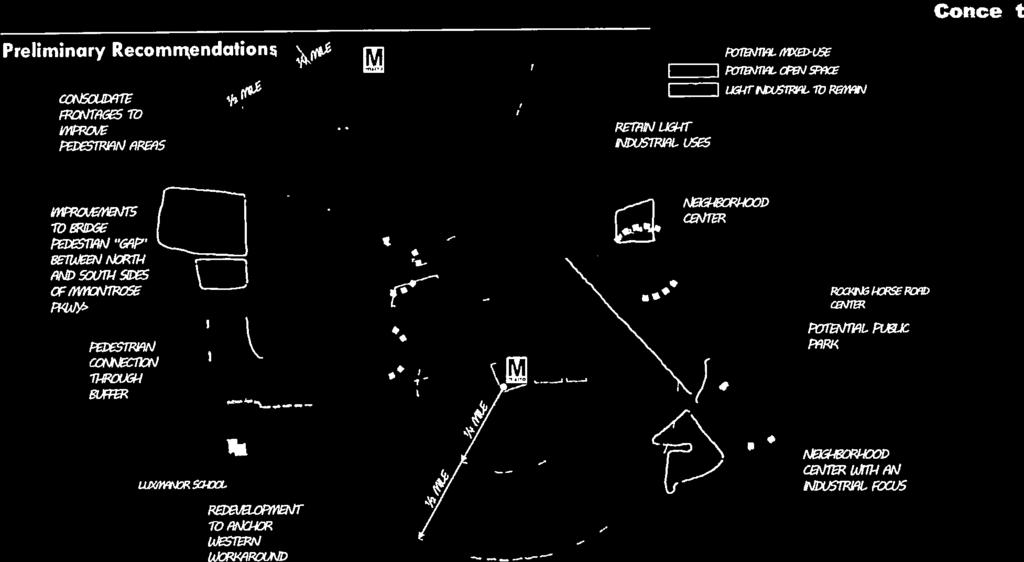
2 VISION The White Flint 2 Sector Plan envisions the future of the area between the White Flint Sector Plan area and the City of Rockville. It will complement the 2010 White Flint Sector Plan by providing opportunities for infill and transitional development at key locations. Commercial properties, especially shopping centers along Rockville Pike, will transform into mixed-use urban places with targeted infill opportunities for the Executive Boulevard office park and two new neighborhood mixed-use centers in the Randolph Hills community. White Flint 2 Concept Plan The White Flint 2 Plan recommends the retention of existing multi-family residential development to further support the broad range of affordable housing options in the Plan area. The retention of light industrial properties will continue to provide needed services for down- County residents and places for small businesses and entrepreneurs. New development will be compatible with existing residential neighborhoods, which will continue to have access to new public amenities and bikeway connections. White Flint 2 will provide mobility options via future Bus Rapid Transit (BRT); new bikeway linkages to adjacent areas; and new parks and open spaces for recreation and enjoyment. White Flint 2 will contribute to the future transformation of Rockville Pike (MD 355) into an urban boulevard with BRT, by filling in a missing gap, and providing linkages to the City of Rockville. New streets will provide enhanced pedestrian and bikeway connections throughout the Plan area, and Montrose Parkway East-Phase II will improve east-west connectivity. 2

3 PLANNING CONTEXT AND FRAMEWORK The White Flint 2 Sector Plan is guided by Montgomery County s 1993 General Plan Refinement that recommends concentrating development at key centers, such as transit station areas, in the I-270 Corridor. The County Council s 2002 Transportation Policy Report (TPR) also recommends increasing housing in the I-270 Corridor, especially at transit station areas, to improve the jobs to housing balance in the Corridor. The Plan area is served by three future Bus Rapid Transit (BRT) Corridors that are recommended in the 2013 Countywide Transit Corridors Functional Master Plan: Rockville Pike (MD 355) South, Randolph Road, and the North Bethesda Transitway. White Flint 2 Plan Area and Context The 1992 North Bethesda/Garrett Park Master Plan focused new development at three Metro Station areas: Twinbrook, White Flint and Grosvenor and other key redevelopable areas, including properties that are in White Flint 2, such as Montrose Crossing Shopping Center. The 1992 Master Plan also recommended the retention of light industrial properties east of the CSX railtracks and the Plan proposed a new MARC Station at Montrose Crossing. The 2009 Twinbrook Sector Plan and the 2010 White Flint Sector Plan are two recently approved plans that build upon the 1992 Master Plan. The Twinbrook Plan, which is northeast of the White Flint 2 Plan area, concentrates new residential and non-residential development near the Twinbrook Metro Station; promotion of technology and Federal institutions; and the retention of light industrial uses. 3
4 The 2010 White Flint Sector Plan is immediately adjacent to the south, west, and east of the White Flint 2 Plan area. The 2010 Sector Plan envisions an urban environment with high intensity mixed-use development surrounding the White Flint Metro Station and along Rockville Pike (MD 355); a new street network; new parks and open spaces; and new public facilities, including a Fire and Emergency Station (EMS), an elementary school and a recreation center. A small portion of the 2010 White Flint Plan area, Nicholson Court, is also included in this White Flint 2 Plan area. North of White Flint 2, the City of Rockville is updating its Rockville Pike Plan. This Plan recommends a multi-way boulevard for approximately 1.98 miles of Rockville Pike with dedicated Bus Rapid Transit (BRT); a network of new streets; new parks and open spaces; and mixed-use development. The context of the White Flint 2 Sector Plan is further shaped by the enactment of the County s new Zoning Ordinance that established several zoning categories, including the Commercial Residential (CR), Commercial Residential Town (CRT) and Employment Office (EOF) Zones for some properties in the Plan area. Commercial shopping centers, including Montrose Crossing and Federal Plaza, were classified into the CR and CRT Zones, respectively, and Executive Boulevard was reclassified into the Employment Office (EOF) Zone. KEY RECOMMENDATIONS Recommendations for the White Flint 2 Sector Plan area builds upon the 2010 White Flint Sector Plan and the 2009 Twinbrook Sector Plan to strengthen and link an important segment of North Bethesda with new urban design guidelines, land uses, parks and open spaces, mobility options, and community facilities. Key recommendations include the following: Land Use and Zoning Promote the transformation of single use commercial shopping centers into mixed-use places along Rockville Pike (MD 355). Integrate new residential and non-residential uses in the Executive Boulevard office park and promote mixed-use neighborhood centers at the Loehmann s Plaza and Randolph Hills Shopping Centers. Retain existing multi-family residential development as an important resource of market rate affordable housing. Retain light industrial properties to provide important services to down County residents, offer opportunities for small scale businesses, entrepreneurs, and vocational and entry-level employment. 4
5 Mobility Extend the Rockville Pike (MD 355) Boulevard concept to the City limits of Rockville with Bus Rapid Transit (BRT). Provide new streets that permit alternative ways to navigate in the Plan area and to link to adjacent communities. Support the 2010 White Flint Sector Plan recommendation for a MARC Station but recognize that Maryland Department of Transportation (MDOT) must develop criteria for infill stations in Montgomery County. Support the expansion of the 2010 White Flint Sector Plan street network, where feasible. Accommodate new bikeways that link to the 2010 White Flint Sector Plan area and the City of Rockville. Urban Design Provide design direction that recognizes the unique context and development challenges of individual areas such as Executive Boulevard, Rockville Pike, and other neighborhood centers identified by the Plan. Encourage design excellence for new development, including quality public use space that complements the guidance of the White Flint and Twinbrook Urban Design Guidelines. Promote walkability with new streets and enhanced streetscape to define the public realm. Promote variety in new building height and massing to maximize access to natural light and air circulation for building occupants, those of neighboring buildings, and surrounding communities and public open spaces. Affordable Housing Promote a diverse mix of housing options for residents at different stages of life. Retain existing multi-family residential development that furthers Montgomery County s Housing Element of the General Plan (2011) to provide a broad range of affordable housing options. Parks and Open Space Create new parks and open spaces for public use to promote a livable environment for existing and future residents, visitors and employees, and to expand the network of interconnected open spaces envisioned by the 2010 White Flint Sector Plan. Link new parks and open spaces with existing and proposed bikeways and trails. Develop at least 12 acres of public use in the Plan area. 5
6 Public Facilities/Community Facilities Support the community facilities recommended in the 2010 White Flint Sector Plan. Provide recommendations to address school capacity issues in the Walter Johnson cluster. Promote the co-location of public facilities to reduce public expenditures and minimize land area. Encourage new prototypes for public facilities that promote innovate design. Sustainability Promote energy efficiency and encourage net zero energy building design. Improve the urban ecology, including goals to reduce heat island effect and promote Environmental Site Design (ESD) in stormwater management practices. Retain existing wooded areas where designated, and provide increased tree canopy throughout the Plan area. Include sustainable solutions in the design of an attractive public realm, to integrate green features, enhance mobility options, and promote walkability. Neighborhood Compatibility Provide adequate transitions between new development and existing neighborhoods through appropriate building heights and development intensities. Promote new pedestrian paths and bikeways between existing residential communities and new mixed-use development. URBAN DESIGN FRAMEWORK The 1992 North Bethesda-Garrett Park Master Plan, the 2009 Twinbrook Sector Plan, and the 2010 White Flint Sector Plan influence the urban design framework for this Plan s recommendations, including the transformation of Rockville Pike into an urban boulevard with a series of mixed-use districts; new local streets to create interconnected local networks; and establishing a distinctive image for each district to increase legibility. The key building, connectivity, and public use space recommendations include the following: Buildings Consider different and innovative types of development, such as infill, adaptive re-use, and partial redevelopment, on properties with existing uses to remain and those with available capacity for growth. Reduce the scale of larger properties by creating compact, mixed-use development patterns that include short blocks and building frontages close to the street. 6

7 Connectivity Consider public streets within larger properties, where indicated by the Plan, to improve local connectivity through the area, and create mobility alternatives to Rockville Pike. Expand the network of potential public streets with additional internal streets that may be privately owned, that are walkable and well-connected to surrounding areas. Public Use Space Consolidate the areas designated for public use space as part of the development process into substantial, programmable, and accessible spaces. Provide alternatives for recreation and leisure in mixed-use settings by: Creating places for community use that are framed and activated by surrounding development and uses, where the public feels welcome to gather and linger. Including alternatives for seating and options for individual and group activities within each space. Utilizing combinations of hardscaped and landscaped areas, depending on the size and location of the space. White Flint 2 Urban Design Context 7

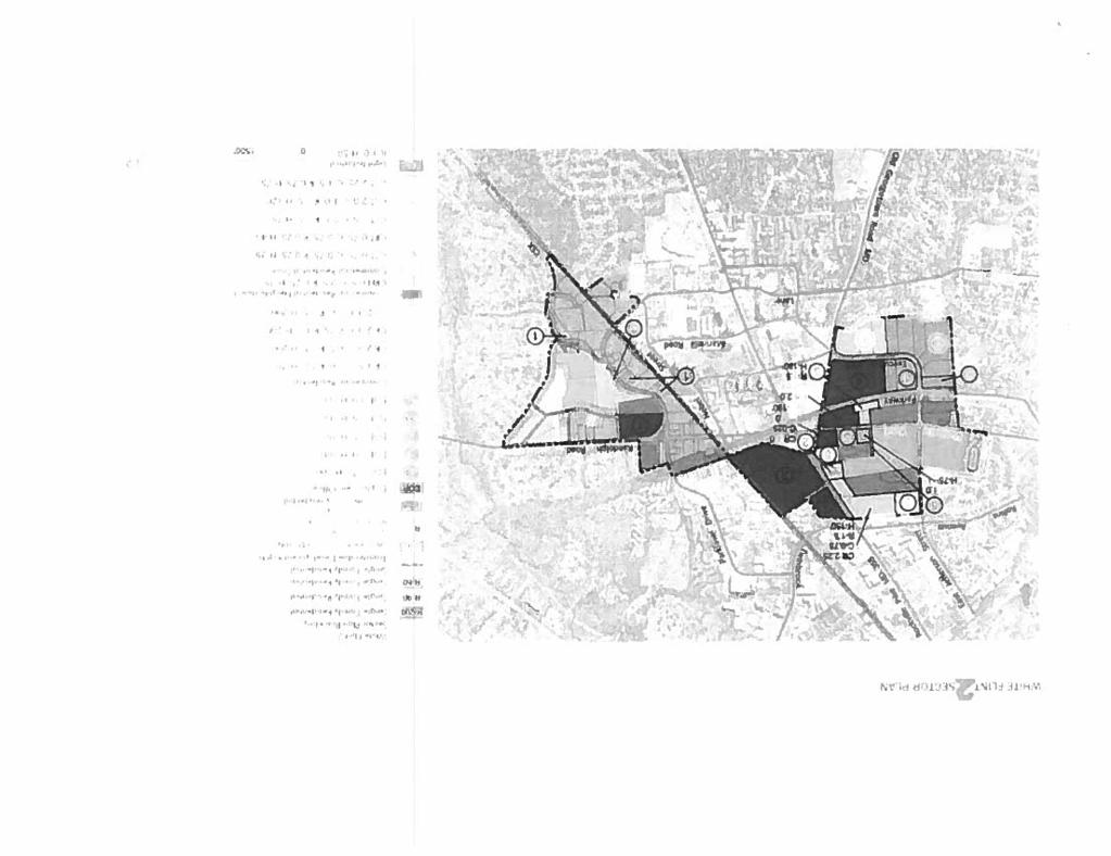
8 WHITE FLINT 2 DISTRICTS The White Flint 2 Plan area includes four major districts: Executive Boulevard, Rockville Pike/Montrose North, Randolph Hills, and Parklawn South. These districts are illustrated below: 2 Montrose North Randolph Hills 3 Parklawn South 1 Executive Blvd. 4 White Flint 2 Districts KEY DISTRICT RECOMMENDATIONS EXECUTIVE BOULEVARD Executive Boulevard, which is a traditional suburban office park with approximately 2.3 million square feet of office development, is located between Montrose Parkway to the north, Pike & Rose to the east, and the Green Acres School to the west. The Luxmanor Local Park and Elementary School and the Luxmanor residential community are located to the south. This district is in the Employment Office (EOF 0.75 H100) Zone. The Plan recommends new Commercial Residential (CR) and Commercial Residential Town (CRT) Zones for key properties close to new infrastructure and development in the 2010 White Flint Sector Plan area. Zoning adjustments are made for properties where the existing built Floor Area Ratios (FARs) are above the 2014 comprehensive rezoning of properties. This district is divided into two segments: Executive Boulevard-North and Executive Boulevard-South. Key 8
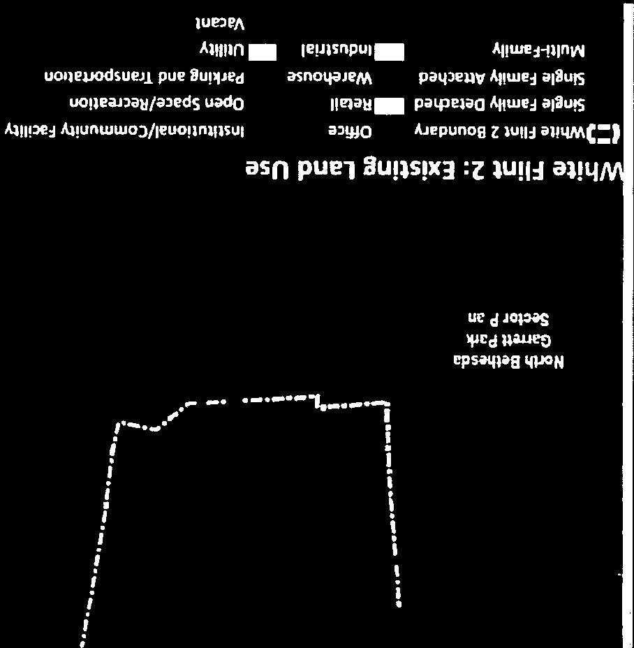
9 land use and zoning recommendations for both segments of the Executive Boulevard district are: Rezone the Washington Science Center property (6001, 6003 and 6011 Executive Boulevard) and the 6101 Executive Boulevard property from the EOF 0.75 H100 Zone to the CR 2.0 C1.0 R1.5 H 200 Zone to permit new mixed-use development in the office park that will implement new public benefits, street network, and will promote vitality for this district. The recommended development mix for this property should not exceed 50 percent of non-residential development. Rezone the properties at 6000 Executive Boulevard, 6010 Executive Boulevard and 6006 Executive Boulevard from the EOF 0.75 H100 to CRT 2.0 C1.0 R1.5 H120 to permit new mixed-use development, provide new public benefits and to transition to the existing Luxmanor residential community. These properties should redevelop with a maximum of 50 percent of non-residential development. Rezone the office properties at 6100 Executive Boulevard, 6110 Executive Boulevard, and 6116 Executive Boulevard from EOF 0.75 H100 to EOF 1.0 H100 to avoid nonconforming buildings. ROCKVILLE PIKE-MONTROSE NORTH Rockville Pike-Montrose North encompasses all of the properties north of Montrose Parkway, including commercial properties, such as Montrose Crossing and Pike Center; multifamily residential developments, including Miramont Condominiums and Apartments and the Morgan Apartments; and institutional uses, including the Jewish Community Center (JCC) and the B nai Israel Congregation. Single-use commercial shopping centers in this district are recommended to transition into mixed-use places with new parks and open spaces; new streets are recommended to promote connectivity; and the Rockville Pike BRT will link to the City of Rockville. Key land use and zoning recommendations for this district are: Rezone the vacant Wilgus properties at 6000 Montrose Road and parcel N231 from the EOF 1.5 H-75 Zone and EOF 3.0 H-100 Zone to the CR2.0 C1.0 R1.5 H-180 Zone to permit mixed-use development that contributes to the Sector Plan s goals of infill mixed-use development with public benefits, including the dedication of an elementary or middle school site. The Federal Plaza shopping center property will be split zoned to permit transitional heights between Rockville Pike and East Jefferson Street, and to maintain compatibility with the residential community in the City of Rockville. Rezone the Monterey Apartments from the CRT 2.25 C1.5 R0.75 H-75 Zone to the CR 4.0 C0.25 R4.0 H-190 Zone to permit a zone that conforms to the built development. 9
10 Rezone the Montrose Crossing property from the CR2.0 C0.5 R1.5 H220 T Zone to the CR 2.0 C0.5 R1.5 H-200 Zone to promote mixed-use development along Rockville Pike, new street network, and to contribute to the Sector Plan s public benefits and amenities. PARKLAWN SOUTH This district is largely east of the railroad tracks but it also includes the Nicholson Court area west of the tracks. There are a variety of industrial uses in this district, including automotive repair and services, self-storage, offices, and catering services. Additional uses in this area include coffee roasters, home improvement contractors and decorating services. There are approximately 84 acres of industrial zoned properties in the Plan area. Industrial zoned properties provide several functions: basic needs for County residents, including public agencies; opportunities for different forms of employment, including vocational and entry-level; and locations for small businesses and artisans. Therefore, the recommendation is to retain the existing light industrial zoned properties in this district. The land use and zoning recommendation is to: Confirm the Light Industrial (IL) Zone for this district. RANDOLPH HILLS The larger properties in this district are: Loehmann s Plaza, a 10.8-acre commercial shopping center, located at the intersection of Randolph Road and Parklawn Drive; two multi-family residential properties, the Walnut Grove Condominium and Oxford Square White Flint; Charles E. Smith Jewish Day School (Upper School) and the Montgomery County Board of Education owned Rocking Horse Road Center. Key land use and zoning recommendations are: Confirm Loehmann s Plaza to the CR 1.5 C0.75 R1.0 H-75 Zone. Residential development at this neighborhood center will contribute to the Sector Plan s public benefits and amenities. Confirm the R-20 Zone for the Walnut Grove Condominium and the R-30 Zone for the Oxford Square White Flint apartments. COMMUNITY FACILITIES The community facilities for this Plan are framed by Montgomery County Public Schools (MCPS) needs for the Walter Johnson School Cluster and the 2010 White Flint Sector Plan recommendations that provided a variety of public facilities, including a recreation center and fire and emergency services. 10

11 2010 White Flint Sector Plan and proposed White Flint 2 Community Facilities Elementary School Most of the Sector Plan area is included in the Walter Johnson Cluster and a small portion is in the Downcounty Consortium. Residential development in this Plan area will generate additional students at each level, particularly at the elementary level in the Walter Johnson Cluster. Demographic changes in existing residential neighborhoods, new infill development, and anticipated development from the approved White Flint and Twinbrook Sector Plans and the proposed Rock Spring Master Plan will also impact the Walter Johnson Cluster. Students generated in the Downcounty Consortium portion of the Plan area can be accommodated at all school levels. Enrollment increases have been occurring at all of these schools and a variety of strategies would be considered to accommodate additional students resulting from the Plan. The Sector Plan recommends the following alternatives to accommodate elementary school needs: Determine if the capacity of existing schools can be increased. At the elementary school level most Walter Johnson cluster schools already operate above capacity or are projected 11
12 to do so in the future. Garrett Park and Luxmanor elementary schools will be impacted by the continued build-out of the 2010 White Flint Sector Plan that is within both school service areas. Elementary schools in the cluster have been expanding to around 740 capacity or are planned to be expanded in the next few years. All cluster schools will be at the high end of the range of student enrollment with capacities ranging from 729 to 881, and no further additions will be considered. Because further increasing the capacity of existing elementary schools is not possible, and the magnitude of enrollment growth is considerable, the opening of a new elementary school would be considered. A new elementary school could be provided in one of the following ways: o Reopen a former elementary school in the Walter Johnson Cluster. There are several former MCPS elementary schools in the cluster that could be reopened, including the former Alta Vista, Arylawn, Kensington and Montrose elementary schools. The former Grosvenor Elementary School also is located in the cluster, but is used as a holding facility for schools undergoing revitalization or expansion. o Construct a new elementary school on a site recommended in the White Flint 2 Plan area. The combined Wilgus and Wilco properties will have a large student impact on the Cluster and it is suitable for an innovative elementary school. A future redevelopment of the property should dedicate land for an elementary school. This location will benefit from surrounding existing and future residential development, including Pike & Rose to the east, and other multi-family residential to the north. o Construct a new elementary school on either the recommended (White Flint Mall) or alternative site (Luttrell) identified in the 2010 White Flint Sector Plan. o If a site is not provided in the White Flint 2 Sector Plan, and the site at the White Flint Mall is not considered a feasible location, then purchase of an elementary school site, or co-location with a park, could be considered. o Consider locating an elementary school site on the Rockinghorse Road Center property in the Randolph Hills neighborhood, which would require adjustments of school boundaries by the Board of Education and relocation of MCPS administrative facilities. This property, which is a former elementary school, has the size of a traditional elementary school, it is located in a residential neighborhood, and it is within the Sector Plan area. In addition to considering the opening of a new elementary school, options to reassign students to elementary schools adjacent to the Walter Johnson Cluster with available capacity could be considered. In addition, if there are schools with small capacities 12
13 adjacent to the Walter Johnson Cluster, then expansion of these facilities to accommodate additional students through reassignments could be considered. Of the clusters adjacent to the Walter Johnson Cluster, the Winston Churchill and Rockville clusters have elementary schools that either have space available or are small and could be expanded. Reassignments to these schools would be considered in the future. Middle School If additional middle school school capacity is needed, options include the former Woodward High School site on Old Georgetown Road and the 11+ acre Wilgus site described above (although MCPS typically prefers a larger site for middle schools and acquisition cost could be a factor). High School No high school site is recommended in the Plan area. Montgomery County Public Schools (MCPS) has conducted an extensive review of long-term needs for the Walter Johnson Cluster via a roundtable discussion with PTAs and other stakeholders. A multitude of options were presented for all school levels, including both middle and high schools. It is anticipated that the MCPS Superintendent will recommend a preferred option addressing projected high school enrollment to the Board of Education in the fall of Currently, the former Woodward High School Site on Old Georgetown Road (between White Flint 2 and Rock Spring) is the only publicly owned site in the vicinity that could potentially accommodate a high school (or combination high school/middle school). PARKS The 2012 Park, Recreation and Open Space (PROS) Plan focuses on how the parks and recreation system meets the needs of our growing population and continues to play a major role in shaping Montgomery County s high quality of life. A central component of PROS is its Service Delivery Strategies to ensure the right parks are put in the right places. The strategies recommend the type, number and general location of lands and facilities needed to the year Current and future plans for urban parks, trails, dog parks, community gardens, and other needed facilities are guided by PROS. As the County becomes more urban, acquiring park sites in growth areas is increasingly difficult because of competition for land. The Urban Park Guidelines, approved by the Planning Board as part of PROS recommends that a system of parks and open spaces be provided for every urban master plan or sector plan area through a combination of public and private efforts. Key parks recommendations are the following: Create a linear park along Montrose Parkway in the excess road ROW and adjacent to the Cherington townhouses. The space should have active senior facilities or a dog park. The existing tree buffer should remain and be enhanced with new plantings. 13
14 Create a minimum 1-acre urban recreational park at the Randolph Hills Shopping Center, if it redevelops. The park should serve a variety of ages with active recreational amenities such as outdoor fitness, skate park, dog park and play areas. Create a minimum 1-acre neighborhood green at the Wilco Property. It should include a level grassy area for events and informal gatherings. SUSTAINABILITY Recommendations for environmental sustainability contribute to long-term economic productivity, physical and mental health and well-being, social equity, and efficient use of resources. Many of these recommendations dovetail perfectly with the White Flint 2 Sector Plan s vision to create a compact, walkable, active mixed-use community that is proximate to transit and existing infrastructure. Key sustainable recommendations are the following: Prioritize environmental public benefit points for tree canopy cover and energy conservation in the CR, CRT and EOF Zones. Promote the use of environmental site design (ESD) techniques to reduce impervious areas. Preserve the existing forested stream buffer south and west of Executive Boulevard and adjacent to the Luxmanor residential community. Preserve portions of the existing forest northeast of Montrose Parkway and East Jefferson Street to integrate it into the setting of a shared use path connecting to the existing shared-use path to the west along the Parkway. Establish green connections east to Rock Creek Stream Valley Park, west to Cabin John Stream Valley Park, and south to the Luxmanor Elementary School and Park. MOBILITY This Plan envisions a safe and efficient multi-modal transportation network that focuses on improving connectivity within the Plan area, as well as with adjacent residential neighborhoods, the White Flint Sector Plan area, the Twinbrook Sector Plan area, and the City of Rockville. The 2010 White Flint Sector Plan recommended a new street network, the transformation of Rockville Pike into an urban boulevard with Bus Rapid Transit (BRT) option, and a bikeway network to create a multi-modal environment. To improve circulation west of Rockville Pike and Towne Road, new streets are recommended to create more walkable and buildable blocks. These recommended streets augment the 2010 White Flint Sector Plan street network, including the extension of Rose Avenue. Street network recommendations include the following: Extend Hubbard Drive westward from Rockville Pike (MD 355) to East Jefferson Street, to provide greater vehicular and pedestrian connectivity through the block, if there is future redevelopment of the Jewish Community Center (JCC) property. Construct a new local north-south business street from Executive Boulevard north past Montrose Parkway and Montrose Road through the curb cut at Stonehenge Place to the 14
 should be converted from a private business street to a public business street.")
15 future Hubbard Drive Extension in order to provide greater vehicular and pedestrian connectivity through the large sized blocks. Chapman Avenue (B-4) should be converted from a private business street to a public business street. This road will provide an important public connection from Bou Avenue and the City of Rockville to future Montrose Parkway, Randolph Road, and the 2010 White Flint Sector Plan area. The proposed White Flint 2 street network is illustrated below. Proposed White Flint 2 Street Network Bikeways This Plan envisions a safe and comfortable network of physically separated bicycle lanes in the portions of the Plan area anticipated to transition toward a more urban context. The proposed bikeway network is illustrated below. 15
16 White Flint 2 Proposed Bikeway Network ZONING The recommended zoning approach for the Sector Plan follows the proposed concept. The Commercial Residential (CR) and Commercial Residential Town (CRT) Zones are recommended in strategic locations, where new mixed-use development is recommended. Several existing zones, including multifamily residential zones, R-30 and R-20, are retained. Similarly, all existing single-family residential zones, R-60, R-90 and R-200 and the light industrial (IL) zone are maintained. The existing and proposed Plan area zones are shown below. 16


17 Existing White Flint 2 Zoning Proposed White Flint 2 Zoning 17
18 PUBLIC BENEFITS The recommended Commercial Residential (CR), Commercial Residential Town (CRT) and Employment Office (EOF) Zones require the provision of public benefits for standard and optional method development in these zones. The following public benefits are priorities for the Plan area: The provision of major public facilities, including but not limited to, a dedicated elementary school site; new neighborhood parks and open spaces; bike share stations; and undergrounding of public utilities. Quality building and site design, including but not limited to exceptional design and public open space. Connectivity and mobility, including but not limited to advanced dedication, streetscape improvement, trip mitigation and transit access improvement. Diversity of uses and activities, including but not limited to care centers, moderately priced dwelling units, dwelling unit mix, and enhanced accessibility for seniors or the disabled. Protection and enhancement of the natural environment, including but not limited to tree canopy, energy conservation and generation, and habitat preservation and restoration. IMPLEMENTATION Staging of development links new development with the provision of public infrastructure required to support the Plan recommendations. The 1992 North Bethesda/Garrett Park Master Plan was approved with short-term, mid-term, and long-term staging triggers, including the creation of a Transportation Management Organization. The 2010 White Flint Sector Plan established a three phased staging plan that linked new development with required infrastructure to support new development in the Plan area. Staff is exploring a means to balance the new infrastructure for the 2010 Sector Plan with the recommendations for this Plan. It is an important priority that infrastructure and development in this Plan does not significantly leap ahead of the 2010 Plan area. 18

19

20

21

22
23
24

25

26

27
28


29

30


31


32
33
Public Meeting: July 11, 2016
 Public Meeting: July 11, 2016 MONTGOMERY COUNTY PLANNING DEPARTMENT Maryland-National Capital Park and Planning Commission Tonight s Agenda Preliminary Recommendations Background and Context 2009 Twinbrook
Preliminary Recommendations
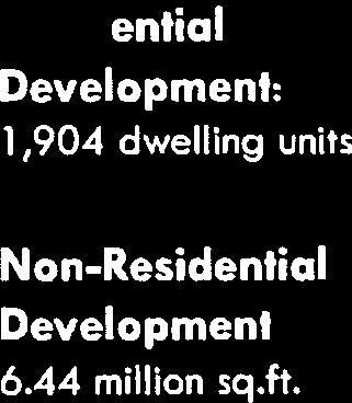
 Preliminary Recommendations Plan Area 2 Plan Context White Flint 2 2010 White Flint Sector Plan 2009 Twinbrook Sector Plan 3 Plan Context 4 Plan Context White Flint Residential Non-Residential Sector Plan
white flint 2 sector plan
 white flint 2 sector plan Public Hearing Draft NOVEMBER 2016 MONTGOMERY COUNTY PLANNING DEPARTMENT M-NCPPC MontgomeryPlanning.org White Flint 2 Sector Plan Public Hearing Draft Abstract This Plan contains
S C O P E O F W O R K A P R I L
 white flint 2 sector plan S C O P E O F W O R K A P R I L 2 0 1 2 MONTGOMERY COUNTY PLANNING DEPARTMENT M-NCPPC MontgomeryPlanning.org 1 white flint 2 sector plan Scope of Work abstract This scope of work
Approved and Adopted JANUARY 2018
 Approved and Adopted JANUARY 2018 Abstract This Plan contains the text and supporting maps for a comprehensive amendment to the approved and adopted 1992 North Bethesda/Garrett Park Master Plan and the
MONTGOMERY COUNTY PLANNING DEPARTMENT THE MARYLAND-NATIONAL CAPITAL PARK AND PLANNING COMMISSION
 MONTGOMERY COUNTY PLANNING DEPARTMENT THE MARYLAND-NATIONAL CAPITAL PARK AND PLANNING COMMISSION MCPB Item No. Date: 09.03.15 White Flint 2 Sector Plan, Scope of Work Nkosi Yearwood, Senior Planner, Area
Rock Spring Master Plan Community Meeting #8: Preliminary Recommendations
 Rock Spring Master Plan Community Meeting #8: Preliminary Recommendations July 18, 2016 Ι Walter Johnson High School Andrea Gilles, andrea.gilles@montgomeryplanning.org Ι www.montgomeryplanning.org/community/rockspring/
Public Forum-Part II: June 20, 2016
 Public Forum-Part II: June 20, 2016 MONTGOMERY COUNTY PLANNING DEPARTMENT Maryland-National Capital Park and Planning Commission Tonight s Agenda I. Schedule and Next Steps II. Presentations i. Abbe Milstein
MONTGOMERY COUNTY PLANNING DEPARTMENT THE MARYLAND-NATIONAL CAPITAL PARK AND PLANNING COMMISSION
 MONTGOMERY COUNTY PLANNING DEPARTMENT THE MARYLAND-NATIONAL CAPITAL PARK AND PLANNING COMMISSION MCPB Item No. Date10/25/12 Sketch Plan No. 32012004, White Flint Mall Redevelopment Nkosi Yearwood, Senior
CONTENTS BACKGROUND AND CONTEXT... 3 Plan Area... 3 History... 3 Previous Planning Initiatives... 4 PLANNING FRAMEWORK... 5 Countywide Transit
 CONTENTS BACKGROUND AND CONTEXT... 3 Plan Area... 3 History... 3 Previous Planning Initiatives... 4 PLANNING FRAMEWORK... 5 Countywide Transit Corridors Functional Master Plan... 5 Veirs Mill Road Bus
Rock Spring Master Plan Community Meeting #6: Land Use + Transportation Forecasts
 Rock Spring Master Plan Community Meeting #6: Land Use + Transportation Forecasts May 23, 2016 Ι Walter Johnson High School Andrea Gilles, andrea.gilles@montgomeryplanning.org Ι www.montgomeryplanning.org/community/rockspring/
THE 355/270 CORRIDOR:
 THE 355/270 CORRIDOR: Strategic Ideas for Sustaining a Livable Work Place Project Summary ACCESS LIFE DESIGN HEALTH WORK Montgomery County Planning Department The Maryland-National Capital Park and Planning
JUSTIFICATION STATEMENT FOR SKETCH PLAN NO Sketch Plan Justification for Wilgus
 JUSTIFICATION STATEMENT FOR SKETCH PLAN NO. 320190070 Sketch Plan Justification for Wilgus I. INTRODUCTION Owner and Applicant, Wilgus-Montrose Associates LLC ( Applicant ), by its attorneys, Linowes and
Establish a network of streetscaped vehicle and pedestrian routes that connect within and outside the Plan area.
 This Plan s urban design goals are to create an urban scale, walkable community with connections to transit, parks, and services and with amenities and facilities for residents and employees. The 1992
Silverdale Regional Center
 Silverdale Regional Center Vision for Silverdale Regional Center The Silverdale Regional Center Plan (Plan) will guide the evolution of the Silverdale Regional Center from a collection of strip malls and
MONTGOMERY COUNTY PLANNING DEPARTMENT
 MONTGOMERY COUNTY PLANNING DEPARTMENT THE MARYLAND-NATIONAL CAPITAL PARK AND PLANNING COMMISSION MCPB Item No.: Date: 5-03-18 Pike and Rose, Phase I: Site Plan Amendment No. 82012002D Rhoda Hersson-Ringskog,
Gold Line Bus Rapid Transit Transit Oriented Development (BRTOD) Helmo Station Area Plan
 Helmo Station Area Plan") Appendix F Gold Line Bus Rapid Transit Transit Oriented Development (BRTOD) Helmo Station Area Plan Introduction and Purpose of the Plan The Gold Line Bus Rapid Transit facility is an eleven-mile dedicated
Appendix F Gold Line Bus Rapid Transit Transit Oriented Development (BRTOD) Helmo Station Area Plan Introduction and Purpose of the Plan The Gold Line Bus Rapid Transit facility is an eleven-mile dedicated
DRAFT. October Wheaton. Design Guidelines
 October 2011 DRAFT Wheaton Design Guidelines 2 Draft - Design Guidelines - Wheaton Sector Plan Contents 04 Section 1: Introduction 06 Section 2: Context 08 Section 3: Design Guidelines 09 Goal 1: Create
MONTGOMERY COUNTY PLANNING DEPARTMENT THE MARYLAND-NATIONAL CAPITAL PARK AND PLANNING COMMISSION
 MONTGOMERY COUNTY PLANNING DEPARTMENT THE MARYLAND-NATIONAL CAPITAL PARK AND PLANNING COMMISSION Rock Spring Master Plan: Briefing and Preliminary Staff Recommendations MCPB Item No. Date: 07/28/2016 Andrea
Status Report: MD 355 Project
 Status Report: MD 355 Project OCTOBER 2006 M-NCPPC MONTGOMERY COUNTY PLANNING DEPARTMENT Summary of Community Comments, and break to the Results of the MD 355 Participation Session Brookside Gardens -
Westwood Shopping Center Sketch Plan, Plan # February 23, 2017 Item # 9
 Westwood Shopping Center Sketch Plan, Plan # 320170010 February 23, 2017 Item # 9 Westwood II Site 64,111 s.f. Manor Care site: vacant two story building HOC-Westwood Towers, 15 story tower To be considered
MONTGOMERY COUNTY PLANNING DEPARTMENT
 MONTGOMERY COUNTY PLANNING DEPARTMENT THE MARYLAND-NATIONAL CAPITAL PARK AND PLANNING COMMISSION Ashburton Elementary School Addition, Mandatory Referral, MR2018009 MCPB Item No. Date: 02-15-18 Troy Leftwich,
MONTGOMERY COUNTY PLANNING DEPARTMENT THE MARYLAND-NATIONAL CAPITAL PARK AND PLANNING COMMISSION
 MONTGOMERY COUNTY PLANNING DEPARTMENT THE MARYLAND-NATIONAL CAPITAL PARK AND PLANNING COMMISSION MCPB Item No. Date: 1/26/12 Hanover Shady Grove, Sketch Plan 320120020 Joshua Sloan, Coordinator, Joshua.Sloan@MontgomeryPlanning.org,
MONTGOMERY COUNTY PLANNING DEPARTMENT
 MONTGOMERY COUNTY PLANNING DEPARTMENT THE MARYLAND-NATIONAL CAPITAL PARK AND PLANNING COMMISSION 6000 Executive Boulevard, Sketch Plan No. 320180140 MCPB Item No. Date: 06/21/2018 Emily Tettelbaum, Senior
MONTGOMERY COUNTY PLANNING DEPARTMENT THE MARYLAND-NATIONAL CAPITAL PARK AND PLANNING COMMISSION
 MONTGOMERY COUNTY PLANNING DEPARTMENT THE MARYLAND-NATIONAL CAPITAL PARK AND PLANNING COMMISSION Staff Report: Sketch Plan #320110010, Mid-Pike Plaza ITEM #: MCPB HEARING DATE: January 20, 2011 REPORT
Shady Grove Sector Plan
 Montgomery Planning Area 2 Division 11/15/2018 Shady Grove Sector Plan Minor Master Plan Amendment Scope of Work Edit presentation title MM/DD/YYYY 1 Purpose for the Plan Amendment 1. Reevaluate/status
At first Work Session on October 22, At second Work Session on November 19, At third Work Session on December 3, 2015
 At first Work Session on October 22, 2015 Staff Reviewed Infrastructure: Transportation Capacity School Capacity Willett Branch Proposed Staging Language At second Work Session on November 19, 2015 Land
MEMORANDUM BACKGROUND. lcouncilmembers should bring their copy of the Plan to the meeting.i. AGENDA ITEM #l0a November 28, 2017.
 AGENDA ITEM #l0a November 28, 2017 Worksession MEMORANDUM November 22, 2017 TO: FROM: SUBJECT: County Council ~ Marlene Michaelson, Senior Legislative Analyst Grosvenor-Strathmore Metro Area Minor Master
Germantown Forward Status Report to the Planning Board M NCPPC
 Germantown Forward Status Report to the Planning Board Germantown Forward March 27, 2008 What s new? CCT alignment Capital Improvement Program Agency partners Water quality conditions Sustainability Design
Preliminary Recommendations Tk Takoma/Langley Crossroads Sector Plan
 Preliminary Recommendations Tk Takoma/Langley Crossroads Sector Plan Vision is to achieve a Transit Oriented, pedestrian friendly Community that Celebrates and builds upon the cultural Diversity of the
MONTGOMERY COUNTY PLANNING DEPARTMENT THE MARYLAND-NATIONAL CAPITAL PARK AND PLANNING COMMISSION
 MONTGOMERY COUNTY PLANNING DEPARTMENT THE MARYLAND-NATIONAL CAPITAL PARK AND PLANNING COMMISSION MCPB Item No. Date: 05/12/2016 North Bethesda Conference Center Parking Structure, Mandatory Referral No.
Transit-Oriented Mixed Use Zoning in Montgomery County, Maryland
 Transit-Oriented Mixed Use Zoning in Montgomery County, Maryland Nkosi Yearwood Community-Based Planning Division Montgomery County Planning Department Rail Volution 2007 Miami, Florida The General Plan
master plan of highways bus rapid transit amendment
 Scope of Work master plan of highways bus rapid transit amendment September 2011 Montgomery County Planning Department M-NCPPC MontgomeryPlanning.org 1 Scope of Work master plan of highways bus rapid transit
Planning Board Briefing
 Planning Board Briefing Why Now? The Sector Plan Implementation Chapter States: Before Stage 1 begins, the following must occur: Approval of the Sectional Map Amendment. Approval of the Greater Lyttonsville
Chapter IV: Development Pattern
 Chapter IV: Development Pattern Introduction The 2002 Prince George s County Approved General Plan designates three growth policy tiers Developed, Developing, and Rural as well as three center designations
Town Center. Block 5 Existing multifamily residential units are expected to remain.
 Area Guidelines Germantown s districts should be developed as distinct communities with unique features that are supported through the guidelines. The guidelines not only help distinguish these districts
MONTGOMERY COUNTY METRO STATION AREA DESIGN CHARRETTE
 MONTGOMERY COUNTY METRO STATION AREA DESIGN CHARRETTE Shady Grove Metro Station Area Charrette Closing Presentation October 25-28, 2000 MONTGOMERY COUNTY, MD M-NCPPC Design Collective, Inc. Architects
Transportation. Strategies for Action
 Transportation A major priority for the Overlake Neighborhood is to develop a multimodal transportation system. To achieve this system, a balance has to be found among travel, circulation and access needs;
38 Queen s University Campus Master Plan Part 1
 38 Queen s University Campus Master Plan Part 1 46 The Campus at the City Scale Chapter 4 The Campus at the City Scale 39 Queen s is an urban University centrally located in Kingston. Decisions made by
Seneca Meadows. Block 4 Locate office, technology, and medical development adjacent to I Screen views of garage structures from I-270.
 Seneca Meadows Seneca Meadows has an industrial park in its southern end and a mixed-use employment area planned for the north end. The district benefits from extensive I-270 visibility, stream valley
MONTGOMERY COUNTY PLANNING DEPARTMENT
 MONTGOMERY COUNTY PLANNING DEPARTMENT THE MARYLAND-NATIONAL CAPITAL PARK AND PLANNING COMMISSION MCPB Item No. Date: 01/11/2018 Veirs Mill Corridor Master Plan: Briefing and Preliminary Staff Recommendations
MONTGOMERY COUNTY PLANNING DEPARTMENT THE MARYLAND-NATIONAL CAPITAL PARK AND PLANNING COMMISSION
 MONTGOMERY COUNTY PLANNING DEPARTMENT THE MARYLAND-NATIONAL CAPITAL PARK AND PLANNING COMMISSION MCPB Item No. 8 Date: 12-15-16 Montgomery Village Center Sketch Plan No. 320170020 TL Troy Leftwich, Senior
Long Branch Sector Plan
 June 2012 Long Branch is one of Montgomery County s most affordable, older communities and has served as a gateway community, especially for newly arriving immigrants, since the 1960s. Many within this
Town Center (part of the Comprehensive Plan)
") Town Center (part of the Comprehensive Plan) Mercer Island Town Center Looking North (2014) In 1994, a year-long process culminated in a set of design guidelines and code requirements for the Town Center
Town Center (part of the Comprehensive Plan) Mercer Island Town Center Looking North (2014) In 1994, a year-long process culminated in a set of design guidelines and code requirements for the Town Center
Welcome to the Oakridge Centre Open House
 Welcome to the Oakridge Centre Open House Why is the City hosting this event? This open house is to inform you of a rezoning application submitted to the City of Vancouver to amend the existing CD-1 (Comprehensive
EXISTING COMPREHENSIVE PLAN
 EXISTING COMPREHENSIVE PLAN Town Center Land Use Element: V. LAND USE POLICIES Town Center Mercer Island's business district vision as described in "Your Mercer Island Citizen-Designed Downtown" was an
The transportation system in a community is an
 7 TRANSPORTATION The transportation system in a community is an important factor contributing to the quality of life of the residents. Without a sound transportation system to bring both goods and patrons
ELMVALE ACRES SHOPPING CENTRE MASTER PLAN
 ELMVALE ACRES SHOPPING CENTRE MASTER PLAN Contents 1.0 INTRODUCTION... 2 2.0 LOCATION... 2 3.0 EXISTING CONTEXT... 2 4.0 VISION & GUIDING PRINCIPLES... 2 5.0 LAND USE AND BUILT FORM... 4 5.1 St. Laurent
Appendix 4 Park, Trail, and Recreation Facilities For more information, call the Park Planning and Stewardship Division at
 Appendix 4 Park, Trail, and Recreation Facilities For more information, call the Park Planning and Stewardship Division at 301-650-4380 montgomery county planning board maryland-national capital park and
BROOKLYN PARK / 85TH AVE LRT STATION CDI DEVELOPMENT GUIDELINES DRAFT
 August 2018 Page intentionally left blank The Brooklyn Park Library adjacent to the 85th Ave LRT Station Area. OVERVIEW The Blue Line LRT Extension / Bottineau corridor offers a unique opportunity to leverage
MONTGOMERY COUNTY PLANNING DEPARTMENT
 MONTGOMERY COUNTY PLANNING DEPARTMENT THE MARYLAND-NATIONAL CAPITAL PARK AND PLANNING COMMISSION Ourisman Ford at Montgomery Mall, Sketch Plan No. 320170100 MCPB Item No. Date: 11-30-17 LS Lori Shirley,
Proposed Comprehensive Plan Strategies DRAFT for discussion June 28, 2017
 Proposed Comprehensive Plan Strategies DRAFT for discussion June 28, 2017 Land Use Rural Areas Refine the Farm and Forest area (FF) Update FF boundaries to account for existing lots less than five acres
CHAPTER 1. Ms. Guajardo s Class - Central Elementary CH 1 1
 INTRODUCTION CHAPTER 1 Ms. Guajardo s Class - Central Elementary CH 1 1 1.1 SETTING South Centre City is a linear corridor south of Downtown Escondido paralleling Centre City Parkway and South Escondido
Sketch Plan. MNCPPC Plan No: A
 General Notes 1. The Sketch Plan drawings are conceptual only and represent proposed development in an illustrative manner. Final building locations, dimensions, heights, uses and development standards
CHAPTER 7: Transportation, Mobility and Circulation
 AGLE AREA COMMUNITY Plan CHAPTER 7 CHAPTER 7: Transportation, Mobility and Circulation Transportation, Mobility and Circulation The purpose of the Transportation, Mobility and Circulation Chapter is to
CHARLES PUTMAN CHARLES PUTMAN AND ASSOCIATES, INC
 MEMORANDUM CHARLES PUTMAN & ASSOCIATES, INC. LAND DEVELOPMENT CONSULTANTS PLANNING ZONING PERMITTING 4722 NW Boca Raton Boulevard, Suite C-106 Boca Raton, Florida 33431 Phone: 561/994-6411 FAX: 561/994-0447
MONTGOMERY COUNTY PLANNING DEPARTMENT THE MARYLAND-NATIONAL CAPITAL PARK AND PLANNING COMMISSION
 MONTGOMERY COUNTY PLANNING DEPARTMENT THE MARYLAND-NATIONAL CAPITAL PARK AND PLANNING COMMISSION MCPB Item No. Date: 1/15/2015 Bethesda North Marriott Hotel and Conference Center: Limited Site Plan Amendment
[PLANNING RATIONALE] For Site Plan Control and Lifting of Holding Zone By-Law 101 Champagne Avenue. May 23, 2014
![[PLANNING RATIONALE] For Site Plan Control and Lifting of Holding Zone By-Law 101 Champagne Avenue. May 23, 2014](/thumbs/75/71599615.jpg "[PLANNING RATIONALE] For Site Plan Control and Lifting of Holding Zone By-Law 101 Champagne Avenue. May 23, 2014") [PLANNING RATIONALE] For Site Plan Control and Lifting of Holding Zone By-Law 101 Champagne Avenue May 23, 2014 Contents 1.0 Introduction... 2 2.0 Site Context... 2 2.1 Adjacent Uses... 2 Figure 1: Site
[PLANNING RATIONALE] For Site Plan Control and Lifting of Holding Zone By-Law 101 Champagne Avenue May 23, 2014 Contents 1.0 Introduction... 2 2.0 Site Context... 2 2.1 Adjacent Uses... 2 Figure 1: Site
ASPEN HILL Minor Master Plan Amendment
 ASPEN HILL Minor Master Plan Amendment Project Briefing Planning Board Agenda Item #7 Andrea Gilles, Area 2 June 5, 2014 Briefing Purpose 1. Follow-up evaluation on Mixed-Use land use in the Minor Amendment
WELCOME and introduction
 1 WELCOME and introduction Mobility Hub Locations within Burlington STUDY OVERVIEW STUDY OBJECTIVES The City of Burlington is developing four Area Specific Plans, one for each of Burlington s Mobility
DRAFT Land Use Chapter
 Stevens Creek Urban Village DRAFT 1 18 17 Land Use Chapter INTRODUCTION This Land Use Chapter describes how the Stevens Creek Urban Village will accommodate the growth that is planned for it in the Envision
June White Flint. Urban Design Guidelines
 June 2010 White Flint Urban Design Guidelines Context Montgomery County s General Plan envisioned urban centers along the I-270 corridor as places where compact, transit serviceable growth and employment
Policies and Code Intent Sections Related to Town Center
 Policies and Code Intent Sections Related to Town Center The Town Center Vision is scattered throughout the Comprehensive Plan, development code and the 1994 Town Center Plan. What follows are sections
LAND USE OVERVIEW WHAT YOU WILL FIND IN THIS CHAPTER
 LAND USE WHAT YOU WILL FIND IN THIS CHAPTER Information about the City s expected population and employment growth. Description and capacity of existing and future land use designations. Policies that
The Five Components of the McLoughlin Area Plan
 The Five Components of the McLoughlin Area Plan This documents contains the complete language of the five components of the McLoughlin Area Plan: The Vision Statement The Values The Guiding Principles
Implementation Guide Comprehensive Plan City of Allen
 Implementation Guide 2030 Comprehensive Plan City of Allen DRAFT 2015 Implementation Guide Allen 2030 Comprehensive Plan INTRODUCTION The Comprehensive Plan serves as a guide for the growth and development
JUSTIFICATION STATEMENT FOR SKETCH PLAN NO Sketch Plan Justification for Ourisman Ford
 I. INTRODUCTION JUSTIFICATION STATEMENT FOR SKETCH PLAN NO. 320170100 Sketch Plan Justification for Ourisman Ford Owner and Applicant, FP Whitro Westlake, LLC ( Applicant ), by its attorneys, Linowes and
RECOMMENDED GOALS, CONCEPTS, GUIDELINES PUBLIC PARTICIPATION PROGRAM
 2015 RECOMMENDED GOALS, CONCEPTS, GUIDELINES PUBLIC PARTICIPATION PROGRAM THE MARYLAND-NATIONAL CAPITAL PARK AND PLANNING COMMISSION PRINCE GEORGE S COUNTY PLANNING DEPARTMENT SEPTEMBER 24, 2015 INTRODUCTION
The University District envisions, in its neighborhood
 Envisioning the University District Link Light Rail in Seattle s neighborhoods CIY OF SEALE CONCEP-LEVEL SAION AREA PLANNING RECOMMENDAION RESOLUION # 30165 EXHIBI L Vision 08.2000 he University District
BROOKHILL NEIGHBORHOOD MODEL ZONING MAP AMENDMENT PREFACE TO APPLICATION
 BROOKHILL NEIGHBORHOOD MODEL ZONING MAP AMENDMENT PREFACE TO APPLICATION June 15, 2015 Revised: August 1, 2016 I. VISION Brookhill is a proposed community based upon the principles of Albemarle County
178 Carruthers Properties Inc.
 178 Carruthers Properties Inc. Planning Rationale for 178 Carruthers Avenue Site Plan Control Application June 2014 Table of Contents 1.0 Introduction 2.0 Overview of Subject Property 3.0 Current Zoning
MONTGOMERY COUNTY PLANNING DEPARTMENT THE MARYLAND NATIONAL CAPITAL PARK AND PLANNING COMMISSION
 MONTGOMERY COUNTY PLANNING DEPARTMENT THE MARYLAND NATIONAL CAPITAL PARK AND PLANNING COMMISSION Bethesda Downtown Sector Plan, Work Session #8 MCPB Item No.8 Date: 02-25-16 Leslye Howerton, Planner Coordinator,
The West Vaughan Employment Area Secondary Plan Policies
 Part 2: The West Vaughan Employment Area Secondary Plan Policies 2.1 General Policies It is the policy of Council: 2.1.1. That the West Vaughan Employment Area (the WVEA), identified on Schedule 1, will
SOUTH NATOMAS COMMUNITY PLAN
 SOUTH NATOMAS Community Plan Part Three : COMMUNITY PLAN AREAS AND SPECIAL STUDY AREAS SACRAMENTO 2030 GENERAL PLAN Contents Community Location... 3-SN-3 Community Vision... 3-SN-4 Community Profile...
Staff Report and Recommendation
 Community Planning and Development Planning Services 201 W. Colfax Ave., Dept. 205 Denver, CO 80202 p: 720.865.2915 f: 720.865.3052 www.denvergov.org/cpd TO: City Council Neighborhoods and Planning Committee
4.1.3 LAND USE CATEGORIES
 4.1.3 LAND USE CATEGORIES a. City Center District The City Center District incorporates the existing character and mix of uses in downtown Belmont to encourage redevelopment and new development in keeping
URBAN DESIGN BRIEF 181 Burloak Drive, Oakville
 URBAN DESIGN BRIEF 181 Burloak Drive, Oakville February 2017 Our File: 1730B 230-7050 WESTON ROAD / WOODBRIDGE / ONTARIO / L4L 8G7 / T: 905 761 5588/ F: 905 761 5589/WWW.MHBCPLAN.COM TABLE OF CONTENTS
Urban Design Manual PLANNING AROUND RAPID TRANSIT STATIONS (PARTS) Introduction. Station Study Areas
 Introduction. Station Study Areas") 111111 PLANNING AROUND RAPID TRANSIT STATIONS (PARTS) Introduction The ION rapid transit system will link Waterloo, Kitchener and Cambridge through a central transit corridor (CTC). There are a number
111111 PLANNING AROUND RAPID TRANSIT STATIONS (PARTS) Introduction The ION rapid transit system will link Waterloo, Kitchener and Cambridge through a central transit corridor (CTC). There are a number
AMITY STATION Revised Concept Plan Review West Rosemary Street Chapel Hill, NC September 27, 2016
 AMITY STATION Revised Concept Plan Review West Rosemary Street Chapel Hill, NC September 27, 2016 DEVELOPER'S PROGRAM Introduction This is a request for review of a Revised Concept Plan by Chapel Hill
Midtown Greenway Land Use and Development Plan Executive Summary
 Midtown Greenway Land Use and Development Plan Executive Summary Introduction The Midtown Greenway Land Use and Development Plan sets policy direction for land use and development in the Midtown Greenway
MONTGOMERY COUNTY PLANNING DEPARTMENT THE MARYLAND-NATIONAL CAPITAL PARK AND PLANNING COMMISSION
 MONTGOMERY COUNTY PLANNING DEPARTMENT THE MARYLAND-NATIONAL CAPITAL PARK AND PLANNING COMMISSION Gables White Flint, Preliminary Plan No. 120150010 and Site Plan No. 820150010 MCPB Item No. Date: 4/30/2015
To ensure that resources will be available to provide a consistent level of public services to the community.
 Future Land Use Plan The land use plan is one of the most prominent chapters in the Stillwater Comprehensive Plan. It provides a visual representation of what the community is expected to look like in
STATEMENT OF JUSTIFICATION CLARKSBURG PREMIUM OUTLETS AT CABIN BRANCH NORTH DISTRICT, PHASE
 STATEMENT OF JUSTIFICATION CLARKSBURG PREMIUM OUTLETS AT CABIN BRANCH NORTH DISTRICT, PHASE 1 Southwest Corner of Clarksburg Road and Interstate-270 Clarksburg, Maryland Application for Site Plan #820140160
WELLINGTON STREET WEST COMMUNITY DESIGN PLAN
 36 3.CDP POLICIES 37 Wellington Street West CDP Vision Statement 38 3.1 Introduction 3.1.1 Purpose The development of buildings and public spaces is influenced by a variety of factors over time. City of
Danvers High Street I-1 District Study
 Danvers High Street I-1 District Study Presentation of Final Recommendations Planning Board Presentation June 26 th, 2018 1 Introductions Metropolitan Area Planning Council Sam Cleaves AICP, Principal
McCowan Precinct Plan Study Background & Deliverables
 1 DRAFT & WITHOUT PREJUDICE McCowan Precinct Plan Study Background & Deliverables In September, 2011, City Planning (Scarborough District) began a study of an area within the Scarborough Centre, identified
Wheaton CBD & Vicinity Sector Plan D E S I G N G U I D E L I N E S
 Wheaton CBD & Vicinity Sector Plan D E S I G N G U I D E L I N E S 1 a b s t r a c t This document contains the design guidelines the property owners, community members, and planners should use to implement
RE-Imagining the Downtown Colorado Springs Master Plan
 RE-Imagining the Downtown Colorado Springs Master Plan 2016 APA Colorado State Conference October 25, 2016 Overview 8:00 Welcome, Introductions, and Overview 8:15 Downtown s Planning History 8:30 A Market
Community Meeting November 18, 2015
 Top Concerns We ve Heard Use of Urban Road Code Total number of units and effect on schools and transportation Land swaps with Parks Department: how do these benefit the community? Zoning classifications:
Official Plan Review
 Official Plan Review Summary Report - The Built Environment August 2014 Part 1: Introduction Planning for a healthy, prosperous and sustainable community is an important goal for our municipality. From
City of Nogales General Plan
 Open Space, Parks, Recreation and Trails City of Nogales General Plan Residents of Nogales place a high priority in the development of a comprehensive system of open space, parks, recreation and trails
2.7 ac park. TOTAL 5,403 DU 1,297,900 sf 1,105,450 sf 3.87 ac 5,563 DU 1,121,200 sf 1,105,450 sf 3.87 ac
 PLAN AMENDMENT 2013-I-B1: SEVEN CORNERS SPECIAL STUDY Summary of Pre-staffing Comments Planner: Bernard Suchicital bsuchi@fairfaxcounty.gov (703) 324-1254 Background On October 29, 2013, the Board of Supervisors
4 C OMMUNITY D ISTRICTS
 4 C OMMUNITY D ISTRICTS N ew development in the Area will include many different types of land uses, including a destination retail area that attracts people from all over the region; recreation opportunities
Sector Plan. Planning Board Draft. montgomery county planning department The Maryland-National Capital Park and Planning Commission
 Sector Plan Planning Board Draft montgomery county planning department The Maryland-National Capital Park and Planning Commission WHITE FLINT ABSTRACT This Plan contains the text and supporting maps for
I. Introduction. Prior Approvals
 Statement of Justification First National Bank 19790 Crystal Rock Drive, Germantown, Maryland Application for Site Plan and Limited Preliminary Plan Amendment I. Introduction DPH Architecture, for First
K. SMART ASSOCIATES LIMITED
 Planning Justification Report Zoning By-Law Amendment 185 King Street North Waterloo, Ontario April 7th, 2017 Project Reference Number 16-245 K. SMART ASSOCIATES LIMITED CONSULTING ENGINEERS AND PLANNERS
City of Tacoma Planning and Development Services
 Agenda Item E-1 City of Tacoma Planning and Development Services To: Planning Commission From: Elliott Barnett, Planning Services Division Subject: Tacoma Mall Regional Center Subarea Plan and EIS Meeting
Mississippi Skyway Preliminary Engineering Report
 EXECUTIVE SUMMARY Mississippi Skyway Preliminary Engineering Report CITY OF RAMSEY, MINNESOTA DECEMBER 2014 City of RAMSEY EXECUTIVE SUMMARY Project Need and Intent The Mississippi Skyway pedestrian bridge
Chapter 1: Introduction
 Chapter 1: Introduction The Penn Avenue Community Works Corridor Vision and Implementation Framework presents an integrated communitybased vision and a coordinated, long-term implementation framework for
Mini Technical Assistance Panel. Rock Spring Park
 Mini Technical Assistance Panel Rock Spring Park May 22, 2013 The Team Jason Bonnet, Forest City Washington Matthew Flis, Town of Vienna William Herbig, National Capital Planning Commission Sophie Lambert,