Chapter One LAND USE ELEMENT
|
|
|
- Augustus Barker
- 6 years ago
- Views:
Transcription
1 Chapter One LAND USE ELEMENT AUTHORITY Section 65302a of the California Government Code requires the County to adopt a "land use element which designates the proposed general distribution and general location and extent of the uses of the land for housing, business, industry, open space, including agriculture, natural resources, recreation, and enjoyment of scenic beauty, education, public buildings and grounds, solid and liquid waste disposal facilities, and other categories of public and private uses of land. The land use element shall include a statement of standards of population density and building intensity recommended for the various districts and other territory covered by the plan. The land use element shall identify areas covered by the plan which are subject to flooding and shall be reviewed annually with respect to those areas. The land use element shall designate, in a land use category that provides for timber production, those parcels of real property zoned for timberland production pursuant to the California Timberland Productivity Act of 1982." Stanislaus County does not have any land which falls under the latter category. 1-1
2 GOALS, POLICIES AND IMPLEMENTATION MEASURES GOAL ONE Provide for diverse land use needs by designating patterns which are responsive to the physical characteristics of the land as well as to environmental, economic and social concerns of the residents of Stanislaus County. POLICY ONE Land will be designated and zoned for agricultural, residential, commercial, industrial, or historical uses when such designations are consistent with other adopted goals and policies of the general plan. IMPLEMENTATION MEASURES 1. In reviewing proposals for amendments to land use designations, the County shall evaluate how the proposal would advance the long-term goals of the County. Responsible Departments: Planning Department, Planning Commission, Board of Supervisors 2. The zoning district map of the County shall be reviewed to verify that no conflicts exist between land use designations and zoning districts. A report of this review shall be submitted to the Planning Commission not later than January 4, Responsible Department: Planning Department POLICY TWO Land designated Agriculture shall be restricted to uses that are compatible with agricultural practices, including natural resources management, open space, outdoor recreation and enjoyment of scenic beauty. IMPLEMENTATION MEASURE 1. Agricultural areas should generally be zoned for 40- to 160-acre minimum parcel sizes. Exceptions include land in a ranchette area so identified because of significant existing parcelization of property, poor soils, location, and other factors which limit the agricultural productivity of the area. Responsible Departments: Agricultural Commissioner, Planning Department, Planning Commission, Board of Supervisors 1-2
3 POLICY THREE Land use designations shall be consistent with the criteria established in this element. IMPLEMENTATION MEASURE 1. Requests for General Plan amendments shall be carefully reviewed for consistency with the criteria established in the DESIGNATIONS section of this element for locating these designations. Applications which are inconsistent shall be denied. Responsible Departments: Planning Department, Planning Commission, Board of Supervisors POLICY FOUR Urban development shall be discouraged in areas with growth-limiting factors such as high water table or poor soil percolation, and prohibited in geological fault and hazard areas, flood plains, riparian areas, and airport hazard areas unless measures to mitigate the problems are included as part of the application. IMPLEMENTATION MEASURES 1. All requests for development which require discretionary approval and include lands adjacent to or within riparian habitat shall include measures for protecting that habitat. Responsible Departments: Agricultural Commissioner, Planning Department, Planning Commission, Board of Supervisors 2. Applications for development in areas with growth-limiting factors such as high water table, poor soil percolation, geological fault areas, flood plains, and airport hazard areas shall include measures to mitigate the problems. Responsible Departments: Public Works, Environmental Resources, Planning Department, Planning Commission, Board of Supervisors 3. Development within the 100-year flood boundary shall meet the requirements of Chapter (Flood Damage Protection) of the County Code and within the designated floodway shall obtain Reclamation Board approval. Responsible Departments: Public Works, Planning Department, Planning Commission, Board of Supervisors 4. The County will continue to enforce the height limiting ordinance near airports. Responsible Departments: Planning Department, Board of Supervisors 5. The County shall enforce the provisions of the Alquist-Priolo Earthquake Fault Zoning Act that limits development in areas identified as having special seismic hazards. See Map 5-1 of the Support Documentation for the location of the zone. Responsible Departments: Building Inspection, Planning Department, Public Works, Planning Commission, Board of Supervisors 1-3
4 POLICY FIVE Residential densities as defined in the General Plan shall be the maximum based upon environmental constraints, the availability of public services, and acceptable service levels. The densities reflected may not always be achievable and shall not be approved unless there is proper site planning and provision of suitable open space and recreational areas consistent with the supportive goals and policies of the General Plan. IMPLEMENTATION MEASURE 1. Residential development shall not be approved at the maximum density if: (1) it threatens riparian habitat; (2) growth-limiting factors such as high water table, poor soil percolation, geological fault areas, and airport hazard areas exist; (3) development is in a designated floodway or does not meet the requirements of Chapter of the County Code; (4) it does not comply with airport height limiting ordinance restrictions; (5) there is lack of, or inadequate, sanitary sewer or public water service; or (6) environmental impacts, including traffic, cannot be mitigated. Responsible Departments: Planning Department, Environmental Resources, Public Works, Planning Commission, Board of Supervisors POLICY SIX Preserve and encourage upgrading of existing unincorporated urban communities. IMPLEMENTATION MEASURES 1. The County in association with the Redevelopment Agency will use redevelopment as a tool to upgrade existing urban areas that meet the requirements of the State of California redevelopment law. Responsible Departments: Planning Department, Stanislaus County Redevelopment Agency, Planning Commission, Board of Supervisors 2. The County will apply for federal and state funds to aid in upgrading existing urban areas. Responsible Department: Redevelopment Agency, Planning Department, Parks and Recreation, County Executive Office, Board of Supervisors 3. Land within the sphere of influence of a community services district, sanitary district or domestic water district shall be rezoned for development only if the US (Urban Service) combining district is used. Responsible Departments: Planning Department, Planning Commission, Board of Supervisors 1-4
5 POLICY SEVEN Riparian habitat along the rivers and natural waterways of Stanislaus County shall to the extent possible be protected. IMPLEMENTATION MEASURE 1. All requests for development which require discretionary approval and include lands adjacent to or within riparian habitat shall include measures for protecting that habitat. Responsible Departments: Planning Department, Planning Commission, Board of Supervisors POLICY EIGHT The County will continue to provide proper ordinances to ensure that flood insurance can be made available to qualified property owners through state and federal programs. IMPLEMENTATION MEASURE 1. Development within the 100-year flood boundary shall meet the requirements of Chapter (Flood Damage Protection) of the County Code and within the designated floodway shall obtain Reclamation Board approval. Responsible Departments: Public Works, Planning Department, Planning Commission, Board of Supervisors POLICY NINE The Land Use Element shall be maintained so that it is responsive to change. IMPLEMENTATION MEASURES 1. The Land Use Element shall be comprehensively updated as found necessary by the Board of Supervisors. Every attempt shall be made to do so at least once every five years. Responsible Departments: Planning Department, Planning Commission, Board of Supervisors 2. All of the community plans shall be reviewed and updated as found necessary by the Board of Supervisors. Substantial changes to these plans shall be permitted only in conjunction with a complete community plan update unless the Director of Planning and Community Development finds that (1) the plan has been completely updated within the past three years and the proposed changes can be adequately evaluated based on that updated plan or (2) the proposed change will have no major or demonstrable impact on the surrounding area or on the community in general. Responsible Departments: Planning Department, Planning Commission, Board of Supervisors 1-5
6 3. An annual report shall be made to the Board of Supervisors on the status of the General Plan and progress in its implementation as required in Section (b) of the Government Code. Responsible Department: Planning Department POLICY TEN New areas for urban development (as opposed to expansion of existing areas) shall be limited to less productive agricultural areas. IMPLEMENTATION MEASURES 1. Requests for designation of new urban areas shall be reviewed by the County to determine whether the land is located in a less productive agricultural area based on considerations identified in the Agricultural Element. Responsible Departments: Planning Department, Agricultural Commissioner, Planning Commission, Board of Supervisors 2. Requests for designation of new urban areas shall be accompanied by a plan and implementation methods to provide all appropriate urban services. Responsible Departments: Planning Department, Environmental Resources, Fire Safety, Sheriff, Parks, Library, Planning Commission, Board of Supervisors 3. Proposed amendments to the General Plan map that would allow the conversion of agricultural land to non-agricultural uses shall be approved only if they are consistent with the conversion criteria stated in the Agricultural Element. Responsible Departments: Planning Department, Planning Commission, Board of Supervisors 1-6
7 GOAL TWO Ensure compatibility between land uses. POLICY ELEVEN Development of residential areas shall be adjacent to existing compatible unincorporated urban development or, in the case of remote development, included as part of a specific plan. IMPLEMENTATION MEASURE 1. The criteria for location of residential areas as described in the DESIGNATIONS section of this element shall be applied to all requests for residential designation. Responsible Departments: Planning Department, Planning Commission, Board of Supervisors POLICY TWELVE The expansion of urban boundaries of unincorporated communities shall attempt to minimize conflict between various land uses. IMPLEMENTATION MEASURES 1. The County shall ensure that expansion of urban boundaries of unincorporated communities is accomplished in an orderly manner to limit the area of conflict as much as possible. Substantial changes to community plans shall be permitted only as specified under Policy Nine, Implementation Measure 2. Responsible Departments: Planning Department, Agriculture Commissioner, Planning Commission, Board of Supervisors 2. Before redesignating land designated Agriculture in the General Plan in the process of expanding an existing unincorporated community, the County shall require that the existing community plan be updated or, if a community plan does not already exist, that one be adopted. Responsible Departments: Planning Department, Planning Commission, Board of Supervisors 3. In the process of establishing a new, self-contained community, the County shall require that a specific plan be adopted before approving the redesignation of any land designated Agriculture in the General Plan. Responsible Departments: Planning Department, Planning Commission, and Board of Supervisors 1-7
8 POLICY THIRTEEN Expansion of urban boundaries of unincorporated communities should be based on infilling and elimination of existing "islands" and should not permit leapfrog development or create new "islands." IMPLEMENTATION MEASURE 1. The County shall not approve applications (such as General Plan amendments, rezones, or tentative maps) for expansion of urban boundaries of unincorporated communities that would create "islands" or disregard infilling. Responsible Departments: Planning Department, Planning Commission, Board of Supervisors POLICY FOURTEEN Uses shall not be permitted to intrude into or be located adjacent to an agricultural area if they are detrimental to continued agricultural usage of the surrounding area. IMPLEMENTATION MEASURES 1. All development proposals that require discretionary action shall be carefully reviewed to ensure that approval will not adversely affect an existing agricultural area. Responsible Departments: Planning Department, Agricultural Commissioner, Planning Commission, Board of Supervisors 2. Proposed amendments to the General Plan map that would allow the conversion of agricultural land to non-agricultural uses shall be approved only if they are consistent with the County's conversion criteria, as stated in the Agricultural Element. Responsible Departments: Agricultural Commissioner, Planning Department, Planning Commission, Board of Supervisors POLICY FIFTEEN Uses should not be permitted to intrude into or be located adjacent to areas that are identified as existing and/or potential sites for solid waste facilities if such uses would not be compatible. IMPLEMENTATION MEASURES 1. Potential conflicts with existing solid waste facilities shall be avoided. Responsible Departments: Environmental Resources, Public Works, Planning Department, Planning Commission, Board of Supervisors 2. When the Countywide Integrated Waste Management Plan is adopted, those sites which are identified as potential solid waste facilities should be protected from land use conflicts. Responsible Departments: Environmental Resources, Public Works, Planning Dept., Planning Commission, Board of Supervisors 1-8
9 GOAL THREE Foster stable economic growth through appropriate land use policies. POLICY SIXTEEN Agriculture, as the primary industry of the County, shall be promoted and protected. IMPLEMENTATION MEASURES 1. The County shall require a 10-acre minimum parcel size for parcels requesting inclusion in the Williamson Act. Responsible Departments: Planning Department, Board of Supervisors 2. As land is designated to accommodate new businesses, the County shall give priority to utilizing less productive agricultural areas. Responsible Departments: Planning Department, Agricultural Commissioner, Planning Commission, Board of Supervisors 3. Specific plans shall be encouraged when non-agricultural uses are proposed within areas designated for agriculture. Responsible Departments: Planning Department, Planning Commission, Board of Supervisors 4. The County shall continue to implement the Agricultural Element. Responsible Departments: Planning Department, Agricultural Commissioner, Planning Commission, Board of Supervisors 5. Where parcels under a Williamson Act contract are divided and result in parcels of less than ten acres, a notice of non-renewal shall be filed for the contract on those parcels. This affects subdivision maps, parcel maps, and lot line adjustments. Responsible Departments: Planning Department, Planning Commission, Board of Supervisors POLICY SEVENTEEN Promote diversification and growth of the local economy. IMPLEMENTATION MEASURES 1. Encourage the Stanislaus County Economic Development Corporation to promote Stanislaus County as a profitable location for industry. Responsible Department: Board of Supervisors 2. The Board shall support the introduction of businesses in the County through consideration of suitable financial mechanisms such as Industrial Revenue Bonds. Responsible Departments: Planning Department, Board of Supervisors 1-9
10 3. Continue to implement achievable components of the 1989 Economic Strategic Plan. Responsible Departments: Planning Department, Planning Commission, Board of Supervisors 4. Encourage the development of new industries and the retention of existing industries that help the community reduce, recycle, and/or reuse waste that would otherwise require disposal. Responsible Departments: Environmental Resources, Board of Supervisors 5. Allow private recreational uses where they are not found to cause land use conflicts. Responsible Departments: Planning Department, Parks and Recreation, Planning Commission, Board of Supervisors 6. Emphasize the conservation and development of significant mineral resources as identified by the State Division of Mines and Geology in its report entitled Mineral Land Classification of Stanislaus County, California (Special Report, 173) by implementing the policies and implementation measures specified under Goal Nine of the Conservation/Open Space Element. Responsible Departments: Planning Department, Planning Commission, Board of Supervisors 7. Strengthen the agricultural sector of the economy by continuing to implement the strategies for agriculture-related economic development identified under Goal One of the Agricultural Element. Responsible Departments: U.C. Cooperative Extension, Agricultural Commissioner, Planning Department, Planning Commission, Department of Environmental Resources, Board of Supervisors 8. Encourage tourism in Stanislaus County by participating in efforts to develop a tourism program, including marketing strategies and objectives. Responsible Departments: Planning Department, Planning Commission, Board of Supervisors POLICY EIGHTEEN Accommodate the siting of industries with unique requirements. IMPLEMENTATION MEASURE 1. The criteria described in the DESIGNATIONS section of this element shall be applied in the siting of industries with unique requirements. Responsible Departments: Planning Department, Planning Commission, Board of Supervisors 1-10
11 POLICY NINETEEN Nonconforming uses are an integral part of the County's economy and, as such, should be allowed to continue. IMPLEMENTATION MEASURE 1. Maintain current Zoning Ordinance provisions (Chapter of the County Code) which permit replacement or expansion of nonconforming uses. Responsible Departments: Planning Department, Planning Commission, Board of Supervisors POLICY TWENTY Facilitate retention and expansion of existing businesses. IMPLEMENTATION MEASURES 1. The County shall support the Stanislaus County Economic Development Corporation. Responsible Departments: Board of Supervisors, Planning Department 2. The County shall investigate the use of federal and state funds to provide incentives for businesses to locate, expand or relocate in Stanislaus County. Responsible Departments: Planning Department, Board of Supervisors 1-11
12 GOAL FOUR Ensure that an effective level of public service is provided in unincorporated areas. POLICY TWENTY-ONE At least three net acres of developed neighborhood parks, or the maximum number of acres allowed by law, should be provided for every 1,000 residents, through land dedication and development, payment of in-lieu-of fees, or other methods acceptable to the Parks Department. IMPLEMENTATION MEASURE 1. Continue to implement the strategies identified under Goal Four of the Conservation/Open Space Element. Responsible Departments: Parks Department, Parks Commission, Planning Department, Planning Commission, Chief Executive Office, Board of Supervisors POLICY TWENTY-TWO Future growth shall not exceed the capabilities/capacity of the provider of services such as sewer, water, public safety, solid waste management, road systems, schools, health care facilities, etc. IMPLEMENTATION MEASURES 1. The County shall continue to implement its Public Facilities Fees Program, which is intended to help finance public facilities needed to maintain current levels of service. Responsible Departments: Chief Executive Office, Public Facilities Fees Committee, Building Inspections Division, Auditor-Controller, Board of Supervisors 2. Only development requests for which sewer service capacity that meets the standards of Measure X and domestic water are available shall be approved. Responsible Departments: Environmental Resources, Planning Department, Planning Commission, Board of Supervisors 3. Benefit assessment districts, County Service Areas (CSA's), Mello-Roos Districts or other similar districts shall be formed as needed to pay for the cost of providing ongoing appropriate services. Responsible Departments: Sheriff, Fire Safety, Library, Public Works, Parks & Recreation, Treasurer-Tax Collector, Auditor-Controller, Environmental Resources, Social Services, Stanislaus Medical Center, Planning Department, Planning Commission, Chief Executive Office, Board of Supervisors 4. The County shall continue to work with independent fire districts to implement fees to help finance public facilities to support their services. Responsible Departments: Fire Safety, Chief Executive Office, Board of Supervisors 1-12
13 5. The current level of service of public agencies shall be determined and not allowed to deteriorate as a result of new development. Responsible Departments: Sheriff, Fire Safety, Public Works, Environmental Resources, Parks & Recreation, Library, Social Services, Stanislaus Medical Center, Planning Department, Planning Commission, Treasurer-Tax Collector, Auditor- Controller, Chief Executive Office, Board of Supervisors 6. Rezoning of property for development prior to: 1) annexation to a special district; or 2) inclusion of such property into a newly formed special district that will provide urban services (i.e. sanitary sewer district, domestic water district, or community service district) shall be approved only if the US zoning district is used as a combining district or comparable requirements are incorporated into a Community Plan District. Responsible Departments: Planning Department, Planning Commission, Board of Supervisors 7. Only development requests which have recognized and mitigated any significant impacts on solid waste reduction, recycling, disposal, reuse, collection, handling, and removal shall be approved. Responsible Departments: Environmental Resources, Planning Department, Planning Commission, Board of Supervisors 8. Only development requests which have recognized and reasonably mitigated significant impacts on school facilities shall be approved. Responsible Departments: Planning Department, Planning Commission, Board of Supervisors 9. The County will coordinate development with existing irrigation, water, utility and transportation systems by referring projects to appropriate agencies and organizations for review and comment. Responsible Department: Planning Department POLICY TWENTY-THREE New development shall pay its fair share of the cost of cumulative impacts on circulation and transit systems. IMPLEMENTATION MEASURES 1. Benefit assessment districts or other similar districts shall be formed as needed to pay for the cost of providing ongoing appropriate transportation services. Responsible Departments: Public Works, Treasurer-Tax Collector, Auditor- Controller, Chief Executive Office, Board of Supervisors 2. Traffic impacts shall be identified and impact mitigation fees shall be paid by the subdivider and/or developer. Responsible Departments: Public Works, Planning Department, Planning Commission, Board of Supervisors 3. The level of service (LOS) for all roadways and intersections shall be at least a "C" level, unless they are located within the sphere of influence of a city that has adopted a lower level of service. Responsible Departments: Public Works, Planning Department, Planning Commission, Board of Supervisors 1-13
14 4. Applicants for General Plan amendments shall coordinate with the Stanislaus Council of Governments (StanCOG) Congestion Management Program to mitigate traffic impacts. Responsible Departments: Planning Department, Public Works, Planning Commission, Board of Supervisors 1-14
15 GOAL FIVE Complement the general plans of cities within the County. POLICY TWENTY-FOUR Development, other than agricultural uses and churches, which requires discretionary approval and is within the sphere of influence of cities or in areas of specific designation created by agreement (e.g., Sperry Avenue and East Las Palmas Corridors), shall not be approved unless first approved by the city within whose sphere of influence it lies or by the city for which areas of specific designation were agreed. Development requests within the spheres of influence or areas of specific designation of any incorporated city shall not be approved unless the development is consistent with agreements with the cities which are in effect at the time of project consideration. Such development must meet the applicable development standards of the affected city as well as any public facilities fee collection agreement in effect at the time of project consideration. (Comment: This policy refers to those development standards that are transferable, such as street improvement standards, landscaping, or setbacks. It does not always apply to standards that require connection to a sanitary sewer system, for example, as that is not always feasible.) IMPLEMENTATION MEASURES 1. All discretionary development proposals within the sphere of influence or areas of specific designation of a city shall be referred to that city to determine whether or not the proposal shall be approved and whether it meets their development standards. If development standards of the city and County conflict, the city's standards shall govern. Responsible Departments: Planning Department, Planning Commission, Board of Supervisors 2. The policies described in the section on SPHERES OF INFLUENCE for projects within a city's sphere of influence or areas of specific designation shall be followed. Responsible Departments: Planning Department, Planning Commission, Board of Supervisors 3. The County shall limit its approval of discretionary projects in spheres of influence to agricultural uses, churches and projects recommended for approval by the city unless such projects are exempt from this implementation measure as a result of individual city/county agreements (e.g., upper McHenry Avenue, Beard Tract areas). Responsible Departments: Planning Department, Planning Commission, Board of Supervisors 4. Discretionary projects in areas zoned other than A-2 (General Agriculture) prior to the applicable agreement with the city within whose sphere of influence the project lies shall not be allowed to develop consistent with the current zone classification unless they first obtain approval for the project from the city. Responsible Departments: Planning Department, Planning Commission, Board of Supervisors 5. Non-discretionary projects in spheres of influence shall be allowed to develop with existing entitlements. Responsible Departments: Planning Department, Building Inspection Division, Public Works Department 1-15
16 GOAL SIX Provide for direct citizen participation in land-use decisions involving the expansion of residential uses into agricultural and open-space areas in order to encourage compact urban form and to preserve agricultural land. POLICY TWENTY-FIVE A. Any decision by the Board of Supervisors of the County of Stanislaus to approve the redesignation or rezoning of land from an agricultural or open space use to a residential use shall require, and be contingent upon, approval by a majority vote of the County voters at a general or special local election. In the event the Board approves the redesignation or rezoning of such land for a residential use, such approval shall not take effect unless and until that decision is approved by an affirmative majority vote of the voters of the County voting on the proposal. B. The requirement set forth in paragraph (A) shall apply to all such decisions affecting land that is designated for agricultural or open space use on the Land Use Map of the County s General Plan as of the effective date of this policy, even if the affected land is, after the effective date, redesignated or rezoned to a use other than an agricultural or open space use. The intent of this paragraph is to ensure that a developer does not launder land by obtaining County approval for a non-residential use (e.g., an industrial or commercial use), and then subsequently obtain County approval for a residential use. C. The Board s decision to approve the redesignation or rezoning of land from an agricultural or open space use to a residential use constitutes the approval of a project for purposes of CEQA. For this reason, the County shall comply with CEQA prior to the Board s decision to approve the redesignation or rezoning, notwithstanding the requirement that the voters approve such redesignation or rezoning. D. Once the voters have approved a land use map designation or land use entitlement for a property, additional voter approval shall not be required for: (1) subsequent entitlement requests that are consistent with the overall approved development project or land-use designation and zoning; and (2) any requested modification to a land-use or zoning designation that does not decrease the number of permitted dwellings, as specified in the exhibits and plans approved by the voters. E. Exemptions. The requirement for voter approval set forth in this policy shall not apply to any of the following: 1. After notice and hearing as required by state law and after compliance with CEQA, the Board of Supervisors may, without a vote of the electorate of the County, approve residential development on land designated for agricultural or open space uses if the Board finds, based on substantial evidence in the record, and HCD certifies in writing, that all of the following circumstances exist: (a) the approval is necessary and required to meet the County s legal fair share housing requirement; and (b) there is no other land in the County or the cities in the County already designated for urban use that can accommodate the County s legal fair share housing requirement. The Board shall not redesignate more than ten (10) acres per year for residential use under this paragraph. 1-16
17 2. Additional acreage may be designated for residential use if the Board finds, and HCD certifies in writing, that the additional acreage is necessary to meet the Board s legal fair share obligation based on maximum multi-family densities. Any proposal approved under this subsection shall be required to have all housing units permanently affordable to persons or families of moderate, low and very low income. The intent of this exemption is to provide sufficient land for housing to accommodate moderate, low and very low income housing, as may be necessary over time under State law. 3. Any development project that has obtained a vested right pursuant to state law prior to the effective date of this policy. 4. Any development project consisting entirely of farm worker housing. F. Definitions. The following definitions apply to this policy: 1. Residential use means any land-use designation, zoning district or other legislative entitlement authorizing, allowing, or consistent with residential development at a density greater than one (1) dwelling unit per ten (10) gross acres. Such density shall not include (a) caretaker housing or other residential uses incidental to the primary use, or (b) farm worker housing. Residential use includes the following land-use designations set forth in the General Plan (1994), all land-use designations that may be adopted by the County in the future that are comparable to such designations, and all zoning districts compatible with such designations: Estate Residential, Low-Density Residential, Medium-Density Residential, Medium High- Density Residential, Planned Development, and Specific Plan. 2. Agricultural or open space use means any land-use designation or zoning district authorizing, allowing, or consistent with residential development at a density of equal to or less than one (1) dwelling unit per ten (10) gross acres. Agricultural or open space use includes the following land-use designations set forth in the General Plan (1994), all land-use designations that may be adopted by the County in the future that are comparable to such designations, and all zoning districts compatible with such designations: Agriculture, Urban Transition, Mineral Resources. 3. General Plan means the Stanislaus County General Plan adopted in or about October 1994, as amended through the effective date. 4. Effective date means the effective date of the Citizen s Right to Vote on Expansion of Residential Areas initiative measure, as established by the California Elections Code. 5. Board or Board of Supervisors means the Stanislaus County Board of Supervisors. 6. County means Stanislaus County. 7. CEQA means the California Environmental Quality Act. 8. HCD means the California Department of Housing and Community Development. G. Duration; Amendment. Goal Six and Policy Twenty-five, shall remain in effect until December 31, 2036, and may be amended or repealed only by the voters of the County at an election held in accordance with State law. 1-17
18 SPHERES OF INFLUENCE BACKGROUND In 1973, Stanislaus County adopted a new General Plan concept called Urban Transition. This designation was placed on property outside the city limits but within the city's general plan boundary. One of the reasons for development of this designation was ongoing conflicts between the County and the cities. The County routinely approved development of land within a city's general plan boundary without regard to consistency with the city's plans. This caused a variety of problems for a city. First, although rare, development sometimes occurred which was not acceptable to the city, therefore, no attempt was made to annex the property resulting in islands of unincorporated area within a city. Second, if the County permitted urban development within the County, there was no incentive for the property owner to annex. This often prevented annexation. Third, even if the city wanted to annex the property and the property owner agreed, the development seldom met city standards with respect to street improvements, landscaping, signage, etc. At this point, there was no recourse for the city to upgrade the requirements. With the adoption of the Urban Transition designation, development in most instances was required to annex before approval. Development which was allowed by ordinance without annexation was referred to the appropriate city for comment. The intent of the referral was to gain city input on whether or not a proposal was consistent with the city's plans and, if so, did the proposed development standards equal what the city would require if development were to occur in the city. Originally, referrals were only made if the general plan designation was Urban Transition although the Urban Transition area is only a portion of the area within a city's general plan boundary. Gradually, referrals were made of all applications within a city's general plan boundary regardless of whether or not the property was designated Urban Transition. In late 1984, the Local Agency Formation Commission (LAFCO) adopted spheres of influence for each city as required by state law. These spheres are "a plan for the probable ultimate physical boundaries and service area of a local agency." (Section of the California Government Code.) Since a sphere of influence is usually the general plan boundary of a city, the term more accurately describes the area in which referrals have been made. POLICY Whenever an application is to be considered which includes property within the sphere of influence of a city or special district (e.g., sewer, water, community services) or areas of specific designation created by agreement between County and City, the following procedures should be followed: 1. Development, other than agricultural uses and churches, which requires discretionary approval from incorporated cities shall be referred to that city for preliminary approval. The project shall not be approved by the County unless written communication is received from the city memorializing their approval. If approved by the city, the city should specify what conditions are necessary to ensure that development will comply with city development standards. Requested conditions for such things as sewer service in an area where none is available shall not be imposed. Approval from a city does not preclude the County decision-making body from exercising discretion, and it may either approve or deny the project. 1-18
19 2. Agricultural uses and churches which require discretionary approval should be referred to that city for comment. The County Planning Commission and Board of Supervisors shall consider the responses of the cities in the permit process. If the County finds that a project is inconsistent with the city's general plan designation, it shall not be approved. Agricultural use and churches shall not be considered inconsistent if the only inconsistency is with a statement that a development within the urban transition area or sphere of influence shall be discouraged (or similar sweeping statement). The city shall be asked to respond to the following questions: (a) (b) Is the proposed project inconsistent 1 with the land use designation on the city's general plan? If so, please include a copy of the map (or that portion which includes the subject property) and the text describing uses permitted for the general plan designation. All findings of inconsistency must include supporting documentation. If the project is approved, specifically what type of conditions would be necessary to ensure the development will comply with city development standards such as street improvements, setbacks and landscaping? In the case of a proposed project within the sphere of influence of a sanitary sewer district, domestic water district or community services district, the proposal shall be forwarded to the district board for comment regarding the ability of the district to provide services. If the district serves an unincorporated town with a Municipal Advisory Council (MAC), the proposal shall also be referred to the MAC for comment. 1 The question is specifically phrased to ask if a proposed project is inconsistent with the General Plan designation. This is intended to (a) encourage a city to specifically designate all land within its Sphere of Influence if it wants to oppose development proposals within the Sphere, and (b) to assure that tangible proof is submitted if denial is requested. This will eliminate the County's dilemma of trying to prove something is consistent with an inadequate General Plan. 1-19
20 DESIGNATIONS The following land use designations shall be used in the unincorporated area of the County. They are intended to further the Land Use Element goals and policies. If any of these designations fall within the sphere of influence of a sanitary sewer district, domestic water district, or community services district that provides services to an unincorporated town, it will be necessary to consult the COMMUNITY PLANS section to determine if any modification of the designation applies. For areas within such a sphere of influence, the community plans indicate the proposed future General Plan designations. State of California requirements for the Land Use Element state the General Plan should designate general distribution and location of land for various kinds of uses. Most of these, such as housing, industry and agriculture, are identifiable by the obvious nature of their specific designations. There are, however, certain kinds of uses which are not so obvious. These uses are education, public buildings and grounds, and solid and liquid waste disposal facilities. In addition, the Land Use Element must identify areas that are subject to flooding. Information follows regarding specific land uses and areas which are subject to flooding. ESTATE RESIDENTIAL Intent. The intent of the Estate Residential designation is to satisfy the desires of people who wish to live on a relatively small parcel in a rural setting and are willing to accept less than the full range of urban services. It should be applied only to land which is beyond the projected ultimate (or 20- year) service area of a city or special district which provides urban services and which is outside the adopted sphere of influence for a community. Zoning. The R-A (Rural Residential) zone is appropriate within this designation. PD (Planned Development) zoning may also be appropriate provided the development does not exceed the established building intensity of this designation. Building intensity normally is zero to one dwelling unit per three acres. Building intensity may increase to two dwellings per three acres for properties with temporary mobile homes as allowed by zoning regulations. Population density averages approximately one to two persons per acre. Appropriate Locations. The Estate Residential designation is appropriate in areas beyond the sphere of influence of a city (or special district which provides urban services) which is a less productive agricultural area but capable of supporting rural residential development. Among the factors to be considered in making this determination are: (1) existing and potential agricultural suitability (availability of irrigation facilities, crop history and potential); (2) surrounding land use (impacts caused by possible intrusion of rural residential uses and non-agricultural uses); (3) septic tank suitability (Environmental Resources standards for minimum area requirements and potential impacts of a concentration of septic tanks); (4) surrounding parcel size (conformity to adjacent parcel sizes); (5) soil type (soil grade and Storie rating); (6) public road access (length of necessary accesses, condition of existing public roads and future plans for both public roads and private access roads as determined by the Department of Public Works); (7) aesthetic characteristics (removal of natural vegetation, impairment of scenic view, introduction of uses or structures not in the same character as the surrounding area); and (8) anticipated environmental impact (removal of habitat of rare or endangered plant or animal, removal of riparian areas and impacts on natural resources). 1-20
21 LOW-DENSITY RESIDENTIAL Intent. The intent of this designation is to provide appropriate locations and adequate areas for single-family detached homes, in either conventional or clustered configurations. Single-family detached dwellings are the predominant housing type in areas so designated, and would remain so under this designation. Semi-detached dwellings and manufactured housing would be consistent with this designation. Zoning. R-A (Rural Residential), R-1 (Single-Family Residential), SCP-R-1-ST (Salida Community Plan, Single-Family Residential Special Treatment Zone) and SCP-R-1 (Salida Community Plan, Single-Family Residential) zones are appropriate within this designation. PD (Planned Development) zoning may also be appropriate, provided the development does not exceed the established building intensity of this designation. The use of the US (Urban Service) combining district in conjunction with any of the above zones would be appropriate for areas adjacent to unincorporated towns so that annexation to and service from the adjoining sanitary sewer district or community services district is required prior to development. Residential building intensity when served by a community services district or sanitary sewer district and public water district is zero to eight units per net acre. Building intensity for areas not served by public water and sewer service is zero to two units per net acre. Population density ranges from zero to 25 persons per net acre in areas served by public water and sewer and zero to six persons per net acre in other areas. Small second units, as permitted by State Law, may increase both the building intensity and the population density to a limited degree within this designation. Appropriate Locations. The Low-Density Residential designation is appropriate in established residential areas characterized by single-family dwellings. It would also be appropriate in areas: (a) designated by the Board of Supervisors for ranchettes of ½ to one acre in size if the area is a less productive agricultural area but capable of supporting rural residential development based on the eight factors to be considered in locating "Estate Residential" land; or (b) adjacent to unincorporated towns which can serve the development after annexation to and service by a sanitary district or community services district. MEDIUM-DENSITY RESIDENTIAL Intent. The intent of this designation is to provide appropriate locations for single- and multi-family units, primarily in semi-detached or clustered arrangements. Typical housing types would be single-family detached manufactured houses, duplexes, triplexes and low-mass multi-family units (townhouses and garden apartments). All lands within this designation shall be within the boundaries of a community services district, sanitary district or similar public district which provides urban services except where such designation existed at the time of adoption of this plan. Zoning. The R-2 (Medium-Density Residential) and SCP-R-2 (Salida Community Plan, Medium Density Residential) zones are appropriate within this designation. PD (Planned Development) zoning may also be appropriate provided the development does not exceed the established building intensity of this designation. PD zoning which allows sewage generated on site to be metered into the disposal system during non-peak hours is encouraged in communities with limited system capacity. Residential building intensity varies from zero to 14 units per net acre. Population density ranges from zero to 45 persons per net acre. Appropriate Locations. The Medium-Density Residential designation would be appropriate in areas adjacent to unincorporated towns where the Board of Supervisors has determined, pursuant to a community plan, that medium-density residential use is needed. These areas will be developed only after annexation to and service by a sanitary district or community services district. 1-21
22 MEDIUM HIGH-DENSITY RESIDENTIAL Intent. The intent of this designation is to provide appropriate locations for housing types including duplexes, triplexes, fourplexes, and apartment buildings. This designation shall be within the boundaries of a community services district, sanitary district or similar public district which provides urban services. Zoning. The R-3 (Multiple-Family Residential) and SCP-R-3 (Salida Community Plan, Multiple Family Residential) zones are appropriate within this designation. PD (Planned Development) zoning may also be appropriate provided the development does not exceed the established building intensity of this designation. PD zoning which allows sewage generated on site to be metered into the disposal system during non-peak hours is encouraged in communities with limited system capacity. Residential building intensity varies from zero to 25 units per net acre. Population density ranges from zero to 85 persons per net acre. Appropriate Locations. The Medium High-Density Residential designation is appropriate in established residential areas characterized by duplexes, triplexes, fourplexes, and apartment buildings. It would also be appropriate in areas adjacent to unincorporated towns where the Board of Supervisors has determined, pursuant to a community plan, that medium high- density residential use is needed. These areas will be developed only after annexation to and service by a sanitary district or community services district. COMMERCIAL Intent. The intent of this designation is to indicate areas best suited for various forms of light or heavy commercial uses, including, but not limited to, retail, service and wholesaling operations. The County has one designation to correspond to the various commercial zoning districts. This designation is intended for lands which demonstrate a valid supportive relationship to other existing or projected urban development. Zoning. C-1 (Neighborhood Commercial), C-2 (General Commercial), H-I (Highway Frontage Commercial), SCP-C-1 (Salida Community Plan, Neighborhood Commercial) and SCP-C-2 (Salida Community Plan, General Commercial) zones shall be considered consistent with this designation. PD (Planned Development) zoning may also be appropriate provided the development does not exceed the established building intensity of this designation. The building intensity shall be determined by Zoning Ordinance development standards for setback, landscaping, height, parking and other requirements except that residential building intensity shall not exceed 25 units per net acre. In no case shall buildings exceed 75 feet in height, nor shall they cover so much of the lot that insufficient area remains for parking, landscaping, etc. In commercial zones which allow dwelling units, population density can range from zero to 85 persons per net acre. Appropriate Locations. The Commercial designation is appropriate in areas already committed to commercial use. In unincorporated towns this designation is appropriate for Central Business Districts and other areas within the sanitary sewer or community services district in sufficient amount to serve the needs of the community. Areas adjacent to community services district may also be appropriate if the US (Urban Service) combining zone is utilized. 1-22
23 INDUSTRIAL Intent. The intent of this designation is to indicate areas for various forms of light or heavy industrial uses, including, but not limited to, manufacturing and warehousing. Generally, the Industrial designation shall be used in areas where public sewer and water are available or where the restrictions of the Planned Industrial designation are inappropriate. The Planned Industrial designation shall be used instead of the Industrial designation unless (a) the property to be designated is intended for a single-use applicant not permitted in the Planned Industrial designation and the applicant needs a very large site (see discussion under Designating New Industrial Areas or (b) the property is adjacent to an existing industrial area which is reaching capacity and whose services can be extended to serve the expansion. Zoning. The LM (Limited Industrial), M (Industrial) and PI (Planned Industrial) zones shall be consistent with this designation. PD (Planned Development) zoning may also be appropriate provided the development does not exceed the established building intensity of this designation. Building intensity is governed by the fact that the Zoning Ordinance prohibits more than 75% coverage of the property by buildings. Buildings for human occupancy shall not exceed 75 feet in height. Population density is almost nonexistent as only one residential unit per parcel is allowed and then only if it is secondary to the industrial use of the property. Existing Locations. Nearly all existing industrial areas are within or adjacent to the sphere of influence of a city or special district which serves an unincorporated town. Only one industrial area (on the northwest corner of Claribel and the Oakdale/Waterford Highway) is removed from an established urban area. Although new areas to be designated Industrial should be chosen based on the criteria discussed in the following section (Designating New Industrial Areas), the following areas already are established and shall remain as being appropriate: The cities/towns of Crows Landing, Denair, Riverbank, Turlock and Westley have industrial areas along railroads which parallel their boundaries. Keyes, Modesto, and Turlock have industrial areas along Highway 99. Oakdale has industrial land around the Hershey plant south of town and near Riverbank is the Norris Industries Plant. Newman has one parcel on the south side of Inyo, east of the city limits designated Industrial, and the southeast corner of Kiernan Avenue and Sisk Road in Salida is also designated Industrial. There are several industrial areas in the Modesto area including (a) the Beard Tract on the south side of Yosemite Boulevard; (b) south 7th Street between Hatch Road and the Tuolumne River; (c) the east side of Crows Landing Road on both sides of Whitmore Avenue; and (d) a portion of the North Modesto Industrial Park on the south side of Kiernan Avenue, west of McHenry. Designating New Industrial Areas. The amount of land designated as Industrial in the County has changed very little in the past 10 years, decreasing slightly through annexation to cities. Although a great deal of land is still available for industrial development, more than 70% is located in the Beard Tract. The criteria listed below shall be used in evaluating potential areas, both for general Industrial designation and for designating sites for industries that need very large sites. There are few industries with the need for extremely large parcels, but they do exist. It is not practical to designate a large industrial area because a large amount of land might lay idle for an extended period of time. If an industry requiring a large site approaches the County or if more industrial sites are needed, the following criteria shall be used in determining whether or not a site is suitable for being designated Industrial: 1-23
24 a. Access. The proposed site should have adequate access to handle the type and quantity of traffic associated with industrial uses without impacting existing facilities. This shall usually mean that the area will be located on a major road at a minimum, with location on a state highway preferred. b. Sewage disposal. Public sanitary sewer service should be available and a written commitment for service received. (Lands suitable for industrial development but without public sanitary sewer service should more appropriately be designated Planned Industrial.) c. Water. An adequate supply of potable water should be available for industrial usage including water needed for fire suppression. Generally this will require a public water supply in order to meet fire flow standards. d. Infrastructure. Other utilities (such as natural gas, electricity) shall be reasonably available to the site as might be required by the proposed uses. e. Topography. The site is physically suitable for industrial development. f. Williamson Act and other constraints to development. The site should be free from constraints such as valid Williamson Act Contracts that would inhibit rezoning and development of the area. g. Conflicts. The proposed site development shall not cause land use conflicts with surrounding properties. From this viewpoint, expansion of existing areas is more desirable than designating totally new areas. h. City general plan land use designation. Any new areas proposed for industrial designation shall not be inconsistent with the General Plan of any city in whose sphere of influence they lie. I. Countywide Integrated Waste Management Plan. Any new areas proposed for industrial designation shall be consistent with the Countywide Integrated Waste Management Plan. PLANNED INDUSTRIAL Intent. The intent of this designation is to provide locations for light industrial development. Such locations may be so designated on the initiative of the County or may be requested by a property owner or group of property owners. The Planned Industrial designation shall be preferred to the Industrial designation as it allows more control of development to ensure that impacts on adjoining properties are reduced. It shall be used largely in areas without public sewer and/or water service but shall only be used if it is practical, both physically and financially, to provide sewage disposal and water service as needed by the proposed development. Zoning. Building intensity will be determined by the County on an individual basis, depending upon the nature and location of the proposed planned development. However, no buildings shall cumulatively occupy more than 70% of the area of any parcel. Population density is almost nonexistent as only one residential unit per parcel is allowed if it is secondary to the industrial use of the property. The A-2 (General Agriculture), PI (Planned Industrial), LI (Light Industrial), IBP (Industrial Business Park), SCP-PI (Salida Community Plan, Planned Industrial) and all industrial or business park related PD (Planned Development) zones shall be consistent with this designation. 1-24
25 Annexation. Areas designated Planned Industrial on the General Plan and rezoned for development which are located within the adopted sphere of influence of a city shall include the requirement that an agreement be signed in a form satisfactory to the city attorney of the affected city and Stanislaus County Counsel guaranteeing that the property on which the planned industrial designation is applicable will be annexed to the affected city upon demand by the city and with the approval of the Stanislaus County Board of Supervisors. Appropriate Locations. Appropriate locations for the Planned Industrial designation shall be based on the same criteria as used for designating new industrial areas. The Planned Industrial designation shall be more appropriate than Industrial in locations with limited or no sanitary sewer capacity or in other locations where restricting the permitted uses is desirable. INDUSTRIAL TRANSITION Intent. This designation is intended for lands within spheres of influence which for the most part are not zoned or developed for industrial usage, but lie in the path of a valid expansion of a contiguous industrial area. Land falling within this designation may continue to be zoned and used for non-industrial purposes pending demand for such industrial expansion. Rezoning for industrial usage should not be approved for less than an entire block or an area adjacent to an existing industrial zone and must be based on evidence of industrial development capability and a program for adequate relocation of any persons to be ultimately displaced. Zoning. Property within this designation shall retain its present zoning until such time as conversion to Industrial is desirable. At such time as a General Plan amendment to Industrial is processed, property will then be rezoned to be consistent with the Industrial General Plan designation. Population density and building intensity within the Industrial Transition areas shall correspond to that of the General Plan designation which most closely matches the zoning of the property in question. Appropriate Locations. The Industrial Transition designation is appropriate in areas within the sphere of influence of a city or town which lie in the path of an expanding industrial area. BUSINESS PARK Intent. The intent of this designation is to accommodate development of modern, employmentintensive uses within the Salida Community Plan. Principal development and employmentgenerating uses allowed within this designation are characterized by research, product development, professional office, commercial, and business services. A full range of other uses may be permitted within the Business Park designation in conformance with the trends of successful contemporary business parks in northern California. Zoning. The SCP-IBP (Salida Community Plan, Industrial Business Park) and PD (Planned Development) zones shall be consistent with this designation. Appropriate Locations. Appropriate location for the Business Park designation is within the Salida Community Plan Amendment Area. 1-25
26 AGRICULTURE Intent. The major portion of Stanislaus County is productive and potentially productive agricultural land. These lands are of economic importance not only to Stanislaus County, but to the state and nation as well, as evidenced by the fact that Stanislaus County ranks very high nationally in production of agricultural commodities. This designation recognizes the value and importance of agriculture by acting to preclude incompatible urban development within agricultural areas. It is intended for areas of land which are presently or potentially desirable for agricultural usage. These are typically areas which possess characteristics with respect to location, topography, parcel size, soil classification, water availability and adjacent usage which, in proper combination, provide a favorable agricultural environment. This designation establishes agriculture as the primary use in land so designated, but allows dwelling units, limited agriculturally related commercial services, agriculturally related light industrial uses, and other uses which by their unique nature are not compatible with urban uses, provided they do not conflict with the primary use. The Agriculture designation is also consistent with areas the overall General Plan has identified as suitable for open space or recreational use and for ranchettes. Zoning. This designation is consistent with an A-2 (General Agriculture) zoning district. PD (Planned Development) zoning may also be appropriate, provided the development does not exceed the established building intensity of this designation. Residential building intensity normally ranges from zero to two dwellings per 40 acres in the A-2-40 zone and up to one dwelling per three acres in A-2-3. Building intensity may increase to two dwellings per three acres for properties with temporary mobile homes as allowed by zoning regulations. Appropriate intensities would correspond for any land zoned A-2-5, A-2-10, A-2-20, A or any other agricultural zoning designation. Building intensity for agricultural buildings is virtually unlimited, provided setbacks as listed in the A-2 zoning district are maintained. Based on a 1980 countywide census figure of 2.77 persons per unit, population density is low, less than one person per acre even in the A-2-3 zone, and much lower than that in A-2-10 or A-2-40 zones. A Planned Development (PD) zone may also be consistent with this designation when it is used for agriculturally-related uses or for uses of a demonstrably unique character, which due to specific agricultural needs or to their transportation needs or to needs that can only be satisfied in the agriculture designation, may be properly located within areas designated as agricultural on the General Plan. Such uses can include, facilities for packing fresh fruit, facilities for the processing of agricultural commodities utilized in the County s agriculture community, etc Appropriate Locations. The Agriculture designation is appropriate in areas where the agricultural land is productive or potentially productive. It is also appropriate in areas identified as suitable for open space, recreation uses or ranchette uses such as the Valley Home, Orange Blossom, South Ceres, South Turlock, and Oakdale/Riverbank areas. URBAN TRANSITION Intent. The purpose of the Urban Transition designation is to ensure that land remains in agricultural usage until urban development consistent with a city's (or unincorporated community's) general plan designation is approved. Generally, urban development will only occur upon annexation to a city, but such development may be appropriate prior to annexation provided the development is not inconsistent with the land use designation of the General Plan of the affected city. If this is to occur, a change in the General Plan designation consistent with the adopted goals and policies to some other land use designation shall be required. 1-26
27 Zoning. Until Urban Transition lands within a sphere of influence are annexed, they should be zoned General Agriculture (A-2). PD (Planned Development) zoning may also be appropriate, provided the development does not exceed the established building intensity for this designation. Building intensity and population density will be the same as under the Agriculture designation. Appropriate Locations. The Urban Transition designation is appropriate for undeveloped land located within the LAFCO-established sphere of influence of a city or town. PLANNED DEVELOPMENT Intent. The Planned Development designation is intended for land which, because of demonstrably unique characteristics, may be suitable for a variety of uses without detrimental effects on other property. Zoning. Land within a Planned Development designation should be zoned A-2 (General Agriculture) until development occurs through Planned Development zoning. A PD (Planned Development) zone (which, with the A-2 zone, are the only zoning districts consistent with this designation) is applied through application and submission of specific development plans. Building intensity and population density would be determined by the County on an individual basis, depending upon the nature and location of the proposed planned development. Appropriate Locations. The Zoning Ordinance indicates that all applications for planned development should be consistent with the General Plan. The following are considered to be valid uses of the planned development designation consistent with the intent of this element: a. Application for uses of unique character (not otherwise allowed as proposed in other zoning districts) for which findings can be made as to the appropriateness of the location and the absence of detrimental effect to the surrounding area. b. Applications falling within an area designated by this element as a Planned Development area, subject to those resolutions within the appendix of this element that define special policy for planned development uses in the following areas: (1) Upper McHenry Avenue, Resolution No (See Appendix 1-1). (2) East F Street, Highway 108/120, Oakdale, Resolution No (See Appendix 1-2). (3) Freeway Interchange and Frontage Roads adjacent to major highways and freeways, Resolution No (See Appendix 1-3). HIGHWAY COMMERCIAL PLANNED DEVELOPMENT Intent. This designation is intended for land located at freeway interchanges where it is necessary to provide services to highway travelers. Zoning. Land within this designation shall be zoned for General Agriculture (A-2) until rezoned to Planned Development (PD). Population density and building intensity will be determined on a caseby-case basis. 1-27
28 Uses within this designation shall be limited to the following as principle uses: Truck Stops Restaurants Motels Service Stations Overnight R.V. Camping Fruit Stands The following uses may be permitted, but only when accessory to the uses listed above: Towing Service Minor Emergency Automobile Repair Convenience Market Wine Tasting Appropriate Locations. The Highway Commercial Planned Development designation is appropriate only for parcels adjacent to a freeway interchange. No property shall be designated Highway Commercial Planned Development and rezoned PD unless findings are made that the change will not be detrimental to the agricultural productivity of the surrounding property and that the subject property is not considered to be one of the County's Most Productive Agricultural Areas. HISTORICAL Intent. The Historical designation is intended to preserve areas of local, regional, state or national historical significance. Historical areas should be protected by zoning controls emphasizing the need for new development (or rehabilitation) to be compatible with the historic nature of the area. When a community plan has been adopted for a designated historic area, guidelines for development shall be followed as established within that plan. Development standards which are applicable elsewhere should be waived if such waiver is consistent with the intent of the Historical designation and does not endanger the public health, safety or welfare. Zoning. This designation shall be considered to be consistent with the County H-S (Historical Site) zoning district. Due to the unique nature of this kind of designation, population density and building intensity for any new projects must be reviewed on an individual basis. For residential uses, however, building intensity should normally be from one to seven units per net acre with a population density of two to 25 persons per net acre. For other uses, building intensity should be consistent with existing development in the area. Appropriate Locations. The Historical designation is intended for areas which are of local, regional, state or national historical significance. MINERAL RESOURCES Background. In December 1993, after more than a decade and a half of requests from the County, the State of California completed its classification of mineral resources in Stanislaus County. This classification was done as part of what will eventually be a statewide series of classifications required by the Surface Mining and Reclamation Act of 1975 (SMARA). The classification is a very detailed inventory of known and/or presumed locations of a wide variety of mineral resources throughout Stanislaus County. 1-28
29 The SMARA classification process is designed to implement the basic intent of the State Legislature to create and maintain an effective surface mining and reclamation policy with regulation of surface mining operations to ensure that: 1. Adverse environmental effects are prevented or minimized and mined lands are reclaimed to a usable condition that is readily adaptable for alternative land use. 2. The production and conservation of minerals are encouraged, while giving consideration to values relating to recreation, watershed, wildlife, range and forage, and aesthetic enjoyment. 3. Residual hazards to public health and safety are eliminated. (Public Resources Code, Sec. 2712) SMARA mandates that, upon completion of the State's inventory, the County as Lead Agency must amend its General Plan to recognize the mineral information classified by the State, assist in the management of land uses that affect areas of statewide and regional significance, and emphasize the conservation and development of identified mineral deposits. The State's findings are published by the State Division of Mines and Geology in a report entitled Mineral Land Classification of Stanislaus County, California (Special Report 173). The classification maps and mineral information contained in that report are incorporated in this General Plan by reference, together with Public Resources Code Section 2710 et seq. (SMARA) and state policy. As indicated in the State's inventory, key minerals commercially excavated in Stanislaus County are construction aggregates, primarily sand and gravel. Significant aggregate areas are shown on the General Plan maps entitled "Aggregate Resource Areas," which are based on more detailed maps provided by the State Division of Mines and Geology. To a large extent, aggregate areas are located in flood plains of rivers and streams, particularly the Tuolumne and Stanislaus Rivers and Orestimba Creek. These significant aggregate resource areas are protected by the Mineral Resources plan designation, coupled with policies and implementation measures under Goal Nine in the Conservation/Open Space Element that emphasize their conservation and development. County zoning regulations (Chapter 21.88) also regulate surface mining permits and reclamation plans in a manner consistent with the intent and requirements of SMARA. Intent. The Mineral Resources designation is an overlay designation intended to protect mineral deposits that have been identified by the state as being of regional or statewide significance. Development of land designated Mineral Resources will be restricted to those kinds of development that will not interfere with the ultimate excavation of the minerals identified by the State as being in the area. Zoning. Land with this overlay designation shall be zoned for General Agriculture (A-2) or a Planned Development (PD) that is consistent with the underlying designation (Agriculture) and will not interfere with the ultimate excavation of the minerals from the area. Building intensities and population densities shall be consistent with those specified for the Agriculture designation. Surface mining permits and reclamation plans shall meet the requirements established in Chapter of the Zoning Ordinance. 1-29
30 Appropriate Locations. The Mineral Resources designation shall be located where the State Division of Mines and Geology has designated land as having a mineral deposit of statewide or regional significance. It also may be located in those areas identified as containing significant deposits but which have not been formally designated by the state. SPECIFIC PLAN Intent. A specific plan is a detailed plan for a specific area of the County. It is guided by and must conform to the General Plan, but its scale permits a relatively detailed level of examination and planning not normally possible in the General Plan. A specific plan is appropriate where major new development or redevelopment is envisioned as spelled out in the Stanislaus County Specific Plan Guidelines. This designation may serve as either an overlay to other General Plan designations, or in the case of more complex and/or larger projects, it may stand as a separate designation. Zoning. Land designated Specific Plan shall be zoned S-P (Specific Plan) for development under an approved specific plan, or the S-P zone may be an overlay zone used in conjunction with other zoning designations. Population density and building intensity standards for different portions of the S-P zone shall be determined by the specific plan approved by the County, as determined on an individual case basis, except where it is used as an overlay, in which case density and intensity shall not exceed that allowed in the underlying designations. Appropriate Locations. The Specific Plan designation is to be used for areas where it is anticipated that a specific plan will be adopted immediately following the General Plan redesignation. The Specific Plan designation is appropriate for areas which exhibit the following characteristics: 1. Rapidly urbanizing areas with significant new demand for public facilities and services; such a site should be at least 100 acres. 2. Unique physical conditions (including unusual natural resources to be conserved). 3. Complex mixture of uses proposed. 4. Multiple ownership in complex developing area. 5. Need to revitalize a marginal or deteriorated area. 6. Large industrial and/or commercial complexes. 7. Very large single-ownership land developments where a significant new community is to be developed in a presently non-urban area. 8. Special study areas. The Director of Planning and Community Development shall determine when a given project will require that a specific plan be prepared. 1-30
31 LAND USE ELEMENT DIAGRAMS 1-31
32 STANISLAUS COUNTY L E G E N D LAND USE Planned Development Planned Industrial Specific Plan Urban Transition RESIDENTIAL Estate $ # % ONE D.U./ 3 ACRES Low-Density 0-2 D.U./NET ACRE OR 0-7 D.U./NET ACRE Medium-Density 0-14 D.U./NET ACRE Medium High-Density 0-25 D.U./NET ACRE ÊÚ Airport Park Solid/Liquid Waste Disposal Site School Agriculture Commercial Highway Commercial / Planned Development Historical Industrial Industrial Transition City Roads RailRoads Rivers Canals 1-32
33 N HART RD MC HENRY AVE ALBERS RD SS A - F 1 CROWS LANDING 2 DEL RIO 3 DENAIR 4 EMPIRE 5 GRAYSON 6 HICKMAN 7 HUGHSON 8 KEYES S9 KNIGHTS FERRY SSSS 10 LA GRANGE 11 NEWMAN 12 NORTH MODESTO 13 MODESTO/CERES 14 OAKDALE 15 PATTERSON S16 RIVERBANK 17 TURLOCK 18 VALLEYHOME 19 WATERFORD S 20 WESTLEY 21 SALIDA INITIATIVE S INDEX I-5 A HOWARD RD 20 5 N 2ND ST 15 SPERRY AVE BECKWITH RD MAZE BLV W GRAYSON RD HWY KIERNAN AVE N CARPENTER RD S CARPENTER RD 2 E L ST W HATCH RD W WHITMORE AVE CROWS LANDING RD W WEST MAIN ST PATTERSON RD 12 9TH ST 13 HWY 99 WEST MAIN ST STATE ROUTE 4 VALLEY HOME RD LON DALE RD HWY 108 CLARIBEL RD 4 E HATCH RD 8 26 MILE RD MILTON RD W F ST 7 F GEER RD LANDER AVE E F ST 14 OAKDALE WATERFORD HWY E WHITMORE AVE 17 S SANTA FE AVE 3 EAST AVE SONORA RD HWY F ST N SANTA FE AVE 19 6 E KEYES RD 9 MONTPELLIER RD YOSEMITE BLV WILLMS RD CRABTREE RD N 1: LA GRANGE RD N 10 LA GRANGE RD S B FINK RD 1 C W STUHR RD 11 N ST D Feet 1-33
34 I-5 TUNSON RD GEER RD MC HENRY AVE PENTECOST DR I-5 S MC CRACKEN RD A HOWARD ROAD D SULLIVAN ROAD CALIFORNIA AQUEDUCT SCALES: VARIOUS HOWARD RD HO SULLIVAN RD I-5 MERCED COUNTY B FINK ROAD WARD AVE ST FRANCIS AVE E EVELYN WY THIEMAN RD CRAWFORD R I-5 FINK RD FINK RD CHARITY WY CHOW CHOW BITRITTO WY C STUHR ROAD KIERNAN AVE CLARIBEL RD W STUHR RD E SERVICE RD TID LAT NO 2 BELL RD F S SANTA FE AVE A.T. & S.F. R.R. 1-34
35 MORAN RD HWY 33 E 5TH ST ARMSTRONG RD CCID MAIN E ST BONITA AVE % FINK RD S.P. R.R. CROWS LANDING RD N 1:9500 CROWS LANDING Feet 1-35
36 CARVER RD CA ST JOHNS RD J6 MC HENRY AVE STANISLAUS RIVER SAN JOAQUIN COUNTY HOGUE RD STEWART RD COUNTRY CLUB DR LADD RD PATT N 1:17000 DEL RIO Feet 1-36
37 TID LATERAL NO. 3 N SANTA FE AVE E TAYLOR RD POWELL RD N WARING RD E ZEERING RD ARNOLD AVE TURLOCK MAIN % MAIN ST STORY RD WALTON ST % E MONTE VISTA AVE N SANTA FE AVE E TUOLUMNE RD LESTER RD N GRATTON RD N 1:14500 DENAIR Feet 1-37
38 FRAZINE RD CODONI AVE ROOT RD LEEK RD CHURCH ST GARST RD MID LATERAL A.T. & S.P. R.R. MID LATERAL % % YOSEMITE BLV S SANTA FE AVE SOUTH AVE MID LATERAL N 1:13400 EMPIRE Feet 1-38
39 STAKES ST HITO DR HITO DR LAIRD ST SAN JOAQUIN RIVER RIVER RD MARY ST J16 W GRAYSON RD COX RD COX N 1:7000 GRAYSON Feet 1-39
40 I ST LAKE RD RIVERVIEW RD LORENZO ST DAVIS ST MONTPELIER RD 4TH ST % TID MAIN HICKMAN RD 6TH ST ELMA ST MONTPELIER RD KYLIE PL DALLAS RD DALLAS RD N 1: Feet HICKMAN 1-40
41 MOUNTAIN VIEW RD MOUNTAIN VIEW RD TULLY RD CHARLES ST CHARLES ST E HATCH RD CERES MAIN A.T. & S.F. R.R. S SANTA FE AVE 7TH ST FOX RD EUCLID AVE E WHITMORE AVE ROEDING RD 7TH ST N 1:15500 HUGHSON Feet 1-41
42 CERES KEYES FAITH HOME RD E REDWOOD RD TID LATERAL WASHINGTON RD E GRA S.P. R.R KAISER RD $ PIONEER RD PRAIRIE FLOWER RD E KEYES RD TID LATERAL WARNER RD FAITH HOME RD JESSUP RD E KEYES RD E BARNHART RD E TAYLOR RD FOOTE RD % NUNES RD N WASHINGTON RD HWY 99 E KEYES W BARN W T N 1:10500 KEYES Feet 1-42
43 SONORA RD CEMETERY RD FRYMIRE RD $ MAIN ST % DENT ST DEAN ST LYNDE ST $ SONORA RD $ SHUPER RD KENNEDY RD HWY RD N 1:8500 KNIGHTS FERRY Feet 1-43
44 N OLD LA GRANGE RD MID MAIN TUOLUMNE RIVER LA GRANGE RD N $ YOSEMITE BLV YOSEMITE BLV % S OLD LA GRANGE RD FLOTO ST YOSEMITE BLV TID MAIN N 1:8000 LA GRANGE Feet 1-44
45 W STUHR RD S.P.R.R. HWY 33 E STUHR RD FIG LN JENSEN RD HWY 33 SHERMAN PKWY E ORISTIMBA RD HARDIN RD HILLS FERRY RD W MARIPOSA ST HARVEY RD S ST R ST Q ST P ST MERCED ST E INYO AVE MERCED COUNTY UPPER RD PRINCE RD N 1:17500 NEWMAN Feet
46 DRY CREEK TUOLUMNE RIVER SALIDA MODESTO $ DALE RD % N 1:10500 MODESTO Feet
47 USTICKS RD BLAKER RD MORGAN RD CENTRAL AVE MOFFETT RD MITCHELL RD DRY CREEK TUOLUMNE RIVER % $ $ ÊÚ N 1:60000 MODESTO/CERES 1-47 CERES KEYES Feet
48 STANISLAUS RIVER HWY SIERRA R.R. EMERY RD DIXON RD SIERRA RD HWY WARNERVILLE RD WREN RD S STEARNS RD STODDARD RODDEN RD S YOSEMITE AVE ALBERS J14 N YOSEMITE AVE KAUFMAN RD VALLEY HOME RD RIVER RD $ % $ $ ÊÚ W F ST E F ST A.T. & S.F. R.R. CRANE RD N 1:49500 OAKDALE Feet
49 SYCAMORE AVE E LAS PALMAS AVE F ACACIA AVE FIG AVE SYC HWY 33 ALMOND AVE HOLLY AVE EUCALYPTUS AVE S 1ST ST BARTCH AVE WARD AVE ELFERS RD MISTLETOE AVE IVY AVE ROSE AVE Feet OLIVE AVE S.P. R.R. ZACHARIAS RD BALDWIN RD SPERRY AVE ROGERS RD J17 I-5 N 1:29000 PATTERSON 1-49
50 CALIFORNIA AVE SAN JOAQUIN COUNTY CENTRAL AVE STANISLAUS RIVER PATTERSON RD STATE HWY 108 A.T. & S.F. R.R. MID MAIN KENTUCKY AVE MORRILL RD CLAUS RD OAKDALE RD ELEANOR AVE HETCH HETCHY AQUADUCT RIVERBANK LATERAL CRAWFORD RD MINNIEAR AVE DAVIS AVE LITT RD ROSELLE AVE MID LATERAL 6 N 1:10500 RIVERBANK SEE MODESTO FOR SOUTH OF CLARIBEL DETAIL 1-50 CLARIBEL RD Feet
51 KEYES TURLOCK GOLDEN STATE BLVD N WALNUT RD ZEERING RD N OLIVE AVE COLORADO AVE TID LATERAL NO 4 MAIN ST JOHNSON RD QUINCY RD DAUBENBERGER RD ÊÚ TID LATERAL NO 5 N 1:41500 TURLOCK Feet 1-51
52 PIONEER AVE DALE RD LAMBUTH RD % VALLEY HOME RD SCHULTZ RD LONE TREE RD J9 % N 1:5000 VALLEY HOME Feet
53 N EUCALYPTUS AVE S REINWAY AVE EL POMAR AVE STAR AVE VINEYARD RD MAIN ST YOSEMITE BLV HICKMAN RD TUOLUMNE RIVER DELAWARE RD N 1:19500 WATERFORD Feet
54 W GRAYSON RD HOWARD RD S.P. R.R. HWY 33 J16 HOWARD RD N 1:10500 WESTLEY Feet 1-54


55 EXHIBIT A-1: AMENDED GENERAL PLAN SALIDA LAND USE DIAGRAM SALIDA LADD ROAD 99 PROPOSED SISK ROAD NEW ROADWAY STODDARD ROAD PROPOSED PIRRONE ROAD EXTENSION DALE ROAD KIERNAN AVENUE (SR 219) HAMMETT ROAD COVERT ROAD TOOMES ROAD 99 BACON ROAD LAND USES RESIDENTIAL Amendment Area Boundary
56 COMMUNITY PLANS Stanislaus County has adopted Community Plans for most of the unincorporated towns in the County. These plans outline the future growth pattern of the town. Each plan is used in conjunction with the General Plan to indicate whether the Urban Transition area will be residential, commercial, industrial, etc. Any requests for rezoning of property designated Urban Transition on the General Plan must be consistent with the proposed use category on the Community Plan. In order to develop land within the sphere of influence which is designated Urban Transition on the Land Use Element of the Stanislaus County General Plan, the developer must request a general plan amendment, rezoning, and submit a tentative map. The latter is only required if development of the property is dependent on approval of a tentative map. The combining "Urban Service (US)" zone shall be used for all such rezoning. Use of this zone will require that the property annex to the appropriate service district (sanitary, water, or community services) prior to development while still requiring that the underlying zone be consistent with the General Plan designation. (PLEASE NOTE: ALL CIRCULATION/TRANSPORTATION DESIGNATIONS IN THE COMMUNITY PLANS, WITH THE EXCEPTION OF THE SALIDA COMMUNITY PLAN WHICH WAS ADOPTED AUGUST 7, 2007, HAVE BEEN SUPERCEDED BY THE FOCUSED GENERAL PLAN UPDATE, GPA , ADOPTED ON APRIL 18, 2006, REFER TO CHAPTER 2) CROWS LANDING It is not anticipated that Crows Landing will experience significant growth in the coming years. Constraints with the existing water systems, lack of sanitary sewer, and existing Williamson Act contracts will keep its growth to a minimum. Projected 2010 population is only 475 compared to the 1980 population of 436. It is anticipated that this growth will be due to infilling rather than community expansion. The Community Plan shown on Map 1A-1 reflects this expectation. DEL RIO COMMUNITY PLAN In 1992 the County approved a major expansion of the Del Rio Community Plan, extending the community south to Ladd Road and from Carver Road east to McHenry. The two-tiered plan requires that a detailed Specific Plan be completed prior to any development in the undeveloped Tier Two area, which lies south of the current developed area of Del Rio. (The Del Rio Community Plan is available as a separate document.) DENAIR COMMUNITY PLAN Land Use. One of the primary land use changes involves establishing an urban buffer area around the community. To achieve an urban buffer, parcels located on the periphery of the Plan Area have been designated as Estate Residential (ER). The Estate Residential land use designation will allow for the gradual blending of urban development with surrounding agricultural uses. Estate Residential also promotes a well-defined rural small town characteristic edge between the City of Turlock and the Community of Denair where agricultural operations may no longer continue as a viable land use option. The future growth forecasted for Denair translates into demand for a variety of housing types. Vacant and underutilized parcels within the existing Denair Community Plan Area offer the potential for meet the forecasted population growth housing needs. Suitable locations for Medium-Density Residential (MDR) and Medium High-Density Residential (MHDR) housing is within the interior of communities, providing residents convenient access to public services, retail shopping and public 1-56
57 transit opportunities. Development of housing at medium and medium high densities in and around the community s commercial district would positively influence the overall appearance of the community and add new residents who are likely to shop in Denair s commercial district. As such, Medium- and Medium High-Density land use designations have been moved from Denair s periphery to its interior. With the community s small size and the proximity to competing commercial centers outside the community (City of Turlock), the community s downtown commercial core takes on a neighborhood convenience and specialty commercial focus that meets the convenience goods and services needs of local residents. In addition, the downtown commercial area can become a gathering place for local community events. To provide an opportunity for the revitalization of Denair s historical urban core, the community s commercial area has been centralized and compacted. Circulation. Waring Road, Taylor Road (west of Waring Road) and Zeering Road (west of Waring Road) are classified as Major Roads. Class II bike lanes are designated along major roadways consistent with the Stanislaus Area Association of Governments Regional Bicycle Transportation Master Plan. Additional Class II bike lanes provide connectivity to downtown, school and recreational facilities and to the multi-purpose trail system. A multi-purpose trail, offering access to a variety of users, including pedestrians, cyclist and equestrians is planned along the canals on the plans eastern and northern edges. The multipurpose trail ties into the community s bikeway network. Public Facilities. The Community of Denair is devoid of parks and other public outdoor areas for recreating, gathering, and socializing. The County s minimum standard for providing adequate parkland is 3 acres of parkland / 1,000 residents. The Community Plan diagram depicts the general location of future neighborhood and community park sites. The general locations of future park sites are conceptual and indicative of park locations based on service area radius, major streets and surrounding land uses. Parks should be located in the general vicinity shown in the Community Plan. The following general standards define the various park designations identified in Denair Community Plan: Neighborhood Park 3 to 5 acres. Neighborhood parks are designed to meet local neighborhood needs, and are intended to be within walking or bicycling distance of one-half mile from neighborhood residences. A neighborhood park service area should avoid crossing any major natural or manmade barriers (e.g., railroads, canals, and major roads) that inhibit access to the park. Neighborhood parks usually emphasize child oriented facilities providing a variety of play spaces and associated amenities. Community Park 10 to 15 acres. A community park should serve the community and be developed to serve specific recreational needs such as baseball, softball, hard court areas, swimming pool, or recreation center. Patrons of these facilities are expected to drive to the park. As such, community parks should provide adequate parking areas and access from collector and/or major roads. The location of the community park should avoid the need to travel through neighborhoods. Care must be taken when siting a community park to avoid conflicting with nearby residential uses. Community parks can be developed as joint-use facilities able to accommodate seasonal storm drainage basins. 1-57
58 Setting. The Community of Denair is located in the south central portion of Stanislaus County, east of the City of Turlock. Most of the community is surrounded by productive farmland, though residential development within the City of Turlock lies only a mile to the west. The community is bisected by the Burlington Northern-Santa Fe Railroad. Development History and Pattern. Originally a Quaker settlement, the Denair community was first called Elmwood Colony and then Elmdale. In the early 1900s, the Modesto Bank subdivided 640 acres as a townsite. John Denair, a railroad superintendent, subsequently purchased the townsite, and the town s name was changed, fittingly, to Denair. The original townsite was surveyed and developed at right angles to the Burlington Northern-Santa Fe Railroad, which runs in a northwest/southeast direction. More recent development patterns have been on the traditional north/south grid, leaving Denair s historic core physically offset from newer development. Land Use. The Denair Community Plan area encompasses 1,013 acres between Taylor Road on the north and Tuolumne Road on the south. The Turlock Irrigation District Main Canal binds Denair on the east while Waring Road generally forms the community s western boundary. The Denair community is buffered by land designated as Estate Residential. This residential land use designation provides a transition from the urbanized environment of the town to surrounding agricultural uses. In the southwest portion of the plan, an agricultural buffer is established between the Denair community and the City of Turlock. Denair s commercial core area is compact to maximize development opportunities. Higher density residential development is located near the downtown commercial core for easy access to downtown services. The Denair Community Plan contains adequate land to support a population of approximately 8,000 residents. Table 1 provides a summary of land uses within the Denair Community Plan area. Table 1: Denair Community Land Use Profile Developed Vacant Total Percent Land Use Acreage Land Acreage Of Total Estate Residential (ER) % Low Density Residential (LDR) % Medium Density Residential (MDR) % Medium High Density Residential (MHDR) % Commercial (C) % Industrial (I) % Parks* % Schools** % Total , % Notes: *Parks vacant land acreage is based upon a calculation need of 3 acres / 1,000 population projected in the Community Plan ** School vacant land acreage assumes two additional elementary schools will need to be provided. 1-58
59 Circulation. Primary roadways within the community are Monte Vista Avenue, Main Street, Zeering Road, Lester Road and Santa Fe Avenue. Traffic within the community is relatively light, with most of Denair s roadways operating at LOS C or better. Signalization of the community s main intersections (Lester Road at Monte Vista Ave/Main Street, Santa Fe Avenue at Main Street and Zeering Road at Gratton Road) will improve traffic flow. Non-motorized transportation is encouraged via a system of recreational trails and bicycle lanes that connect the Community s residential areas with downtown, recreational and school facilities and along the irrigation canals at the Community s edge. Public Services Wastewater Collection and Treatment. The Denair Community Services District provides wastewater service. Wastewater is conveyed to the City of Turlock Wastewater Treatment Plant for treatment. For the past 13 years, growth in Denair has been retarded due to the capacity of the sewer interceptor between Denair and Turlock.. Wastewater collection system improvements are underway to improve delivery of wastewater to the City of Turlock Wastewater Treatment Plant. Water Service. The Denair Community Services District provides potable water service to the Denair community. Domestic water is supplied by wells that pump groundwater. Water quality is good and no treatment is provided Law Enforcement. Law enforcement is provided by the Stanislaus County Sheriff s Department that maintains a sheriff s substation within the Denair community. The California Highway Patrol shares space with the County Sheriff s Department in the substation located on East Main Street. Fire Protection. The Denair Fire District (DFD) has the responsibility for fire protection, paramedic services and emergency rescue services to Denair and surrounding areas. The DFD is a volunteer fire department. Response time within the Denair community is 3 to 5 minutes. Schools. Denair is located within the Denair Unified School District. The District has one elementary school (K-4), one middle school (5-8) and one high school (9-12). To accommodate growth, the Community Plan identifies general locations for future school sites. Parks and Recreation. The Denair Community Services District provides park and cultural activity centers services in the community. The community s current parkland inventory does not meet the County standard of 3 acres of parkland per 1,000 residents. The Community Plan illustrates the general location of future park sites, including 1 Community Park and 3 neighborhood parks. 1-59
60 Goals, Policies and Implementation Measures The following goals, policies and implementation measures are directed specifically toward the Denair community and are intended to guide development within the Denair Community Plan Area: GOAL ONE Reinforce Denair s small rural town character. POLICY ONE The County shall work with the Denair Municipal Advisory Committee, and other interested groups, to develop a Downtown Master Plan for the planning and implementation of programs to support the vitality of the downtown area. The Master Plan should include detailed development guidelines for downtown. POLICY TWO Promote the vitality of Denair s central business district and preserve Denair s small town character by encouraging it to become a unique shopping district and community events area with a variety of retail commercial, office residential, civic, cultural and recreational uses. POLICY THREE Reduce the area currently designated for commercial uses in the community as a means of concentrating retail activity in a focused area. IMPLEMENTATION MEASURES 1. Develop gateway treatments to mark the entries to the downtown at Santa Fe Avenue and Main Street and at Gratton Road and Main Street. 2. Create a pleasant pedestrian street environment through attractive streetscape design and features including street trees, lighting, sidewalks and planters. 3. Develop design guidelines for new and existing building renovation in the downtown, in keeping with a small town, pedestrian oriented street character. 4. Consider use of Redevelopment Agency funds for enhancement projects. 1-60
61 GOAL TWO Provide a well-defined community edge between Denair and adjacent agricultural land, as well as between Denair and the City of Turlock. POLICY ONE Create a greenbelt / buffer around the perimeter of the Community that provides clear sense of identity for the Community of Denair. POLICY TWO The Denair Community Plan should promote very low density residential uses along the Community s edge or periphery in order to reduce conflicts with surrounding agricultural uses, as well as to establish and define a permanent buffer between Community of Denair and the City of Turlock. IMPLEMENTATION MEASURES 1. Estate Residential shall be designated along the northerly, westerly and easterly periphery of the Denair Community Plan Area to reduce urban density toward the edge of the Community Plan Area. 2. The sizing of sewer and water lines should be reduced as they approach the northerly, westerly and easterly periphery of the Denair Community Plan Area to limit growth influences beyond the Plan Area. 3. Landscape design requirements shall be considered for new projects, which develop along the entryways to the Community of Denair, in particular to Waring Avenue, Monte Vista Avenue, Gratton Road and Santa Fe Avenue. Landscape design should promote a sense of transition from the surrounding agricultural area to urban setting. Utilization of trees to screen urban uses along these entryways is encouraged. 4. Within the Community Plan area, properties designated Low Density Residential and located outside the boundaries of the Denair CSD, may be designated, Low Density Residential or Estate Residential on the General Plan. (This will allow development of ½ acre lots with public water or 1 acre lots without public water or public sewer.) 1-61
62 GOAL THREE Provide for the non-motorized transportation needs of the Denair Community. POLICY ONE Provide safe and convenient pedestrian and bicycle facilities to various destinations throughout the Community of Denair. POLICY TWO Provide pedestrian and bicycle facilities that link community residents to schools, parks, civic facilities and the community's downtown core in accordance with the Denair Community Plan diagram. POLICY THREE The Community pedestrian and bicycle facilities shall connect to regional pedestrian and bicycle facilities. IMPLEMENTATION MEASURES 1. Develop irrigation canals as non-motorized transportation enhancement to promote the walking, cycling and other non-motorized means of transportation. 2. The County shall explore a cooperative agreement with the Turlock Irrigation District to use canal right-of-way / easement for multi-purpose recreational trails, as identified on the Denair Community Plan diagram. 3. Bicycle facilities shall be included as part of road improvement projects where said roadways are identified as bike lanes on the Denair Community Plan. 1-62
63 GOAL FOUR Provide for the recreational needs of residents of the Denair Community. POLICY ONE New development shall provide the residents of Denair with adequate parkland facilities to meet the County standard of 3 acres per 1,000 residents. IMPLEMENTATION MEASURES 1. The County shall work to acquire and develop parkland, including adequate facilities to accommodate one community park. The general location of future park sites is portrayed on the Community Plan diagram. HICKMAN COMMUNITY PLAN Significant population growth is not anticipated in Hickman. Presently, the service area is mostly developed and there has been little demand for expansion. Some growth is expected in existing lots, but there are a limited number of vacant lots that front on County roads. KEYES COMMUNITY PLAN Land Use. Growth forecasted for Keyes translates into a demand for a variety of housing types. Vacant and underutilized parcels within the existing Keyes Community Plan Area, along with a northward expansion of the Community Plan Area offer the potential for providing the forecasted population growth housing needs. Growth, in the form of residential development, has been directed east of State Route 99 to avoid conflicts with industrial uses west of State Route 99. With the exception of an established mobile home park located north of Turlock Irrigation District s Upper Lateral 2½, Medium - and Medium High-Density land use designations are moved from the periphery of Keyes to the interior of the community. Establishment of medium and medium highdensity housing adjacent to the community s commercial districts and public amenities will accommodate long-range housing needs for the community and County, while encouraging a compact community form. With the community s small size and proximity to competing commercial centers outside the community (Cities of Ceres and Turlock), the community s commercial designations take on a neighborhood convenience focus. The Commercial designations within the community are intended to provide essential community retail goods and services. Activities may range from a single commercial use to a neighborhood shopping center. The Highway Commercial land use designation adjacent to the State Route 99 / Keyes Road Interchange is intended to provide for and promote concentration of commercial uses serving the needs of the traveling public. The State Route 99/Keyes Road Interchange also serves as an important gateway into the community. Industrial and Planned Industrial land uses west of State Route 99 are buffered from sensitive land uses to the east of the highway. Industrial and Planned Industrial uses are afforded direct access to heavy rail service, and vital regional north-south and east-west transportation corridors. 1-63
64 The Community Plan includes an area designated Urban Transition. The Urban Transition land use designation recognizes the lands current commitment to Williamson Land Conservation Act contracts. The Urban Transition land use designation also recognizes the importance of this area in the overall development of community-wide circulation improvements and relationship to adjacent planned urban land uses. It is anticipated this area will, in the future, be developed as Low Density Residential. Community Character. Community character is crucial for establishing the overall vision of what constitutes a desirable and viable community. The present appearance of the community along the State Route 99 corridor, as with many corridor communities, is unattractive. A lack of urban landscaping, key community entryways and unsightly land uses adjacent State Route 99 contribute to a negative image which discourages interest in investing in the community. The residents of Keyes envision a cohesive small town that encourages social interaction among its community members. The Plan along with its goals, policies and implementation measures address neighborhood character, community edge and entryways into the community. The community core along 7 th Street has its own unique character as a pedestrian-oriented concentrated area of residential, commercial, and public and quasi-public uses. Future development should enhance the vitality of the community core along 7 th Street while retaining a diversity of residential, commercial and public and quasi-public uses. Circulation. Faith Home Road (north of Keyes Road), Keyes Road (east of Faith Home Road) and Golden State Boulevard (south of Keyes Road) are classified as Major Roads. Rohde Road, 7 th Street, Nunes Road, and Washington Road are classified as Collectors. To promote a traditional local street pattern that evenly disperses traffic throughout the community, the Plan identifies the alignments for future roadway extensions. The Community Plan includes future easterly roadway extensions of Hollywood Drive, Anna Street, Esmail Avenue, Maud Avenue and Norma Way to serve east-west circulation. The Community Plan also includes future northerly roadway extensions of Jennie Avenue and Stella Avenue to serve north-south circulation. To optimize Highway Commercial opportunities and accommodate forecasted traffic volumes on Washington Road, Ninth Street between Nunes and Keyes Roads should be abandoned. In its place, Washington Road should be extended to Keyes Road, opposite Golden State Boulevard. These modifications will improve circulation within the community and create a clear distinction between highway commercial and community related commerce, while establishing an opportunity for a prominent gateway for the community. The broad open area of the highway on- and off-ramps provides an opportunity for establishing a distinctive landscaped entry into the community. The Community Plan encourages bicycling and walking. Two forms of non-motorized transportation routes are depicted on the Community Plan Diagram. Bike lanes are designated along major roadways consistent with the Stanislaus Council of Governments (formally Stanislaus County Area Association of Governments) Regional Bicycle Transportation Master Plan. Bike lanes provide connectivity to neighborhoods, commercial centers, school and recreational facilities. A multi-purpose trail, offering access to a variety of users including pedestrians, cyclists and equestrians, is planned along Turlock Irrigation District s Upper Lateral No 2½ right-of-way. The multi-purpose trail, which ties into the community s bikeway, provides a completely separated rightof-way with minimum cross flows by motorists. Parks. Hatch Park is the only park available to all residents of Keyes. This park does not meet the County s minimum standard of providing 3 net acres of parkland/1,000 residents needed to support the community s current population. To accommodate growth, the Community Plan diagram envisions the expansion of Hatch Park into a community park. The Community Plan also identifies the general location of future neighborhood park sites. The neighborhood park symbols do not denote precise park locations, but suggest approximate locations for additional parkland acquisitions. 1-64
65 The following general standards define the various park designations identified in the Keyes Community Plan: Neighborhood Park 3 to 5 Acres. Neighborhood parks are designed to meet local neighborhood needs, and are intended to be within walking or bicycle distance of one-half mile from neighborhood residences. A neighborhood park service area should avoid crossing any major barriers (e.g., canals, collectors or major roads) that inhibit access to the park. Neighborhood parks should emphasize child-oriented facilities providing a variety of play spaces and associated amenities. Neighborhood parks should also be bound on all four sides by local streets to promote safety and public access. Hatch Community Park 15+ Acres. To provide for recreational needs of the community such as baseball, softball, and hard court areas, and family-oriented activities such as picnic areas and an indoor recreation center, Hatch Park should be enlarged to provide a minimum of 15 acres. Patrons are expected to drive to this facility. As such, Hatch Park should be bound by streets to minimize on-site parking requirements. As a highly active center, residential or other noise sensitive land uses should not directly abut the park. Schools. Keyes is served by two school districts providing elementary and secondary education. The Keyes Unified School District provides for elementary (grades K-8) education. The Turlock Joint Union High School District provides for secondary (grades 9-12) education. Existing, planned and proposed school sites are shown on the Community Plan diagram. The proposed elementary school symbol does not denote the precise school site location, but suggests an approximate location for an additional elementary school. Development History and Pattern. Keyes dates back to 1871 when it was a railroad siding of the Central Pacific (now Union Pacific) Railroad. The siding was named Keyes Switch, after Thomas J. Keyes, a state senator who resided nearby. The community grew slowly, consisting of only 16 families when the Keyes Grammar School was established in The construction of the school and a church spurred additional growth, which slowed once more during the Great Depression. In the 1990s, the community grew faster than the County on average and reached an estimated 3,400 residents by Like many other Central Valley towns, Keyes original townsite was laid out at right angles to the northwest/southeast trending railroad. More recent development patterns have been on a traditional north/south grid, leaving Keyes historic core physically offset from newer development. State Route 99 parallels the Union Pacific Railroad corridor to the east. The State Route 99 bypass, constructed in the mid-1980s, physically divides the community. Land Use. The Keyes Community Plan area contains adequate land to support a population of approximately 9,300 residents. The Community Plan accommodates future growth in the most efficient manner possible. The Community Plan is aimed toward maintaining a compact urban form, preserving surrounding agricultural lands. The Plan area encompasses 857 acres between the Turlock Irrigation District Lateral Number 2-1/2 on the north and Keyes Road on the south. Faith Home Road serves as the community s western boundary. Washington Road serves as the community s eastern boundary. The majority of commercial and residential land uses lie east of State Route 99 while industrial uses are located to the west of State Route 99. New residential development is targeted for the community s northern and eastern areas. The Community Plan also includes land designated as Urban Transition. This land is presently under Williamson Land Conservation Act contract. Should the Williamson Act contracts not be renewed in the future, the land may be developed as Low Density Residential. 1-65
66 The Community Plan encourages the development of commercial areas which conveniently serve residential population, provide employment opportunities, form an attractive segment of the community and contribute to the County s tax base. Commercial development opportunities are provided at the northwest intersection of Washington Road and Keyes Road, and at the planned intersection of Faithhome Road and Hollywood Drive. In addition, the Keyes Community Plan designates land adjoining Golden State Boulevard, Keyes Road and State Route 99 for highway commercial development. Industrial uses are primarily located west of State Route 99. Table 1 provides a summary of land uses within the Keyes Community Plan area. Table 1: Keyes Community Land Use Profile Developed Vacant Total Percent Land Use Acreage Land Acreage Of Total Low Density Residential (LDR) % Medium Density Residential (MDR) % Medium High Density Residential % (MHDR) Commercial (C) % Highway Commercial (HC) % Industrial (I) % Planned Industrial (PI) % Urban Transition (UT) % Parks* % Schools** % Total % Notes: *Parks vacant land acreage is based on a calculation need of 3 acres/1,000 residents projected in the Community Plan. Vacant parkland is representative of the Community Plan Proposed Parks symbol which denotes general location. ** Schools vacant land acreage includes the planned middle school to be developed adjacent to Washington Road, and for one additional elementary school that will be needed. Circulation. The Community Plan identifies the location and extent of existing and proposed major roads, collector streets and local streets, as well as bikeways and rail lines. The Keyes Road interchange provides a vital link to the community from State Route 99. Keyes Road, Faith Home Road, Rohde Road/7 th Street, Washington Road and Esmail Avenue are the community s primary roadways. Non-motorized transportation is encouraged via a system of recreational trails and bicycle lanes that connect the community s residential neighborhoods with retail centers, recreational and school facilities, and other public facilities. 1-66
67 Public Services Wastewater Collection and Treatment. The Keyes Community Services District provides wastewater collection. Wastewater is conveyed to the City of Turlock wastewater treatment plant for treatment. Population growth in Keyes has been impeded due to capacity limitations of the sewer interceptor between Keyes and the City of Turlock wastewater treatment plant. Wastewater collection system improvements are underway to improve delivery of wastewater to the City of Turlock wastewater treatment plant. Water Service. The Keyes Community Services District provides water service to the Keyes community. Domestic water is supplied by wells that pump groundwater. The groundwater is treated at the well head prior to being conveyed to customers. Law Enforcement. Law enforcement is provided by the Stanislaus County Sheriff s Department. The County maintains a Sheriff s substation within the Keyes community. The California Highway Patrol shares space with County s sheriff s Department in the sub-station located on 7 th Street. Fire Protection. The Keyes Fire Protection District provides fire protection and paramedic services to the Keyes and surrounding areas. The District is a volunteer fire department. The average response time is two minutes. Schools. Keyes is located within the Keyes Unified School District and the Turlock Joint Union High School District. The Keyes Unified School District has three schools, one charter school (K-8), one elementary school (K-8) and one pre-school all located on one campus site. Improvements are underway for a new middle school (Grades 6 8). The new middle will be located in northeast section of the community plan area, adjacent to Washington Road. The Community Plan Diagram depicts the general location of a future elementary school site. High school-aged students (Grades 9 12) currently attend Turlock High School. Construction is underway for a new high school (Pitman High School) between Taylor Road and Christofferson Parkway. Once completed, it is anticipated that Keyes high school-aged students will attend Pitman High School. Parks and Recreation. The County provides and maintains one park facility within the community of Keyes. The community s current parkland inventory does not meet the County standard of 3 acres of parkland per 1,000 residents needed to support the community s present population. The Community Plan includes expanding Hatch Park into a 15 acre Community Park. The Community Plan also depicts the general location of future neighborhood park sites. 1-67
68 Goals, Policies and Implementation Measures The following goals, policies and implementation measures are directed specifically toward the Keyes community and are intended to guide development within the Keyes Community Plan Area: GOAL ONE Achieve a harmonious relationship between the urban environment and surrounding agricultural setting. POLICY ONE Provide a land use pattern that is compatible with surrounding land uses and which provides an effective transition between the built environment and agricultural uses along the periphery of the community. POLICY TWO Discourage the designation/rezoning of residential land uses on land sharing a boundary with agriculture designated lands outside the Community Plan Area. POLICY THREE Provide adequate setbacks and/or non-residential improvements between residential development and adjacent agricultural land uses outside the Community Plan Area. POLICY FOUR Cooperate with the City of Ceres to the north and the City of Turlock to the south in establishing definitive community separator policies/implementation measures. IMPLEMENTATION MEASURES 1. Residential land use designations/rezoning that share a boundary with agricultural designated lands outside the Community Plan area shall demonstrate that a 200 foot building setback or other comparable development setback can be provided. Setbacks may include physical improvements such as roads and canals. 2. Commercial, Highway Commercial, and Planned Industrial development shall be buffered from adjacent agricultural land uses outside the Community Plan Area by landscaping elements. 1-68
69 GOAL TWO Improve the visual appearance of the Keyes community. POLICY ONE Encourage the development of identifiable community boundaries to establish a sense of community identity. POLICY TWO Encourage the development of Gateway treatments at major entryways to the community. POLICY THREE Encourage the upgrading, beautification and revitalization of existing commercial areas along 7 th Street. POLICY FOUR Develop and Implement Design Guidelines for new development and for revitalization of existing development within Keyes. POLICY FIVE Promote alternative design solutions to reduce the negative visual impact of walled developments within Keyes. IMPLEMENTATION MEASURES 1. The County should adopt Design Guidelines for the Keyes Community. The guidelines should address residential subdivision design and connectivity, non-residential development, and design/establishment of a gateway/entry features for Keyes. 2. Gateway treatments should be established at the State Route 99/Keyes Road Interchange, and at Rohde Road and the crossing of the Turlock Irrigation District s Upper Lateral No 2 ½. 3. Develop positive, high quality landscaped edges along State Route 99 and major roads leading into the community 4. The County shall approve development proposals which include walls only if walls are necessary in order to mitigate the negative impacts of noise, visual separation from traffic, or to provide a barrier between incompatible land uses. Where walls are necessary, the County shall require separation from the roadway by a curb-adjacent sidewalk and a six-foot landscaped planter strip. A combination of walls, berming and vegetation is considered more desirable than walls used alone. 1-69
70 GOAL THREE Encourage attractive and orderly development which preserves a small town atmosphere. POLICY ONE Provide a diverse community that integrates residential, commercial and industrial land uses supported by public facilities. POLICY TWO Create an enhanced streetscape environment through the use of landscape and pedestrian access along arterial and collector streets. POLICY THREE Medium and High Density Residential should be located along collectors, and be designed and oriented in order to function as part of the overall neighborhood. POLICY FOUR Provide adequate lands to accommodate the development of commercial areas which will conveniently serve current and future residential needs. POLICY FIVE Minimize conflicts between industrial and planned industrial land uses by concentrating industrial activity west of State Route 99. POLICY SIX Provide convenient and accessible neighborhood commercial areas within the community to minimize vehicular trips needed for frequently used retail services. POLICY SEVEN Multi-family residential land uses shall be developed with a balance of open space, landscaping, and shall be accessible to commercial and recreational areas and public transportation facilities. 1-70
71 IMPLEMENTATION MEASURES 1. Commercial development shall be consistent in scale and character with surrounding neighborhood. 2. Commercial sites shall be developed in such a manner to not preclude direct access from residential areas for pedestrian and bicycle traffic. 3. County shall encourage and seek the revitalization of existing housing stock within the central core of the community. 4. County shall encourage and assist the commercial revitalization of 7 th Street. 5. Walled and isolated residential enclaves shall be discouraged. 6. Residential areas shall be designed to create a pattern of activity that promotes community interaction within and with abutting neighborhoods. 7. Parks and schools shall be located and designed as neighborhood focal points. 8. Residential rear yards with walls shall be discouraged along collector streets within the interior of the community to avoid walled subdivisions. In situations where collectors with walls adjoin residential areas, cul-de-sacs should be used to create wall openings with pathway connections to encourage pedestrian access. 9. Development adjacent to Turlock Irrigation District Upper Lateral No 2½ shall maintain an open edge along the Lateral rather than backing against the Lateral. 1-71
72 GOAL FOUR Promote highway-oriented commercial development in the State Route 99 corridor. POLICY ONE The County shall encourage the location of businesses and services (e.g., restaurants, service stations, lodging) in the State Route 99 corridor to serve the traveling public and local residents. IMPLEMENTATION MEASURES 1. Designate land adjacent to the State Route 99/Keyes Road Interchange with good highway visibility and access as Highway Commercial. Permitted uses shall be those determined by the County to be supportive of the overall goals and policies of the Keyes Community Plan. 2. Limit development adjoining State Route 99/Keyes Road Interchange to large sites and nonresidential uses with generous landscaping. 3. The County shall designate land in the Golden State Boulevard/Keyes Road/State Route 99 Interchange corridor area as Highway Commercial. 1-72
73 GOAL FIVE Provide an interconnected system of streets and roads to distribute traffic and meet the circulation needs of the Community. POLICY ONE The County should promote development of a traditional grid circulation system that distributes traffic, provides connectivity and offers multiple-route choices for motorists, as portrayed on the Keyes Community Plan Diagram. POLICY TWO Open street patterns, that create a network of circulation connections with multiple points of ingress and egress are encouraged. POLICY THREE All roadways shall be designed to complement the urban development pattern and coordinate with pedestrian, bicycle and transit routes. IMPLEMENTATION MEASURES 1. The County shall evaluate development proposals for conformance with the circulation system depicted on the Keyes Community Plan Diagram. 2. Recognizing the community s land use pattern, limited number of continuous north-south and east-west streets will result in less than acceptable service standards on a small number of streets, the following roads shall be extended and designated as Collectors as depicted on the Community Plan: a) Esmail Avenue shall be extended to Washington Road; b) Starlite Drive shall be extended to Washington Road; and c) Washington Road shall be extended to Keyes Road. The following local roads shall be extend to improve continuous north-south and east-west circulation as depicted on the Community Plan: a) Maude Avenue shall be extended to Washington Road; b) Anna Avenue shall be extended to Washington Road; c) Jennie Avenue shall be extended to future Starlite Drive extension; and d) Stella Avenue shall be extended to future Starlite Drive extension. 1-73
74 GOAL SIX Provide for the non-motorized transportation needs of the Keyes Community. POLICY ONE Provide safe and convenient pedestrian and bicycle facilities to various destinations throughout the community of Keyes. POLICY TWO Provide pedestrian and bicycle facilities that link community residents to schools, parks, civic facilities and the community s retail centers in accordance with the Keyes Community Plan diagram. POLICY THREE Community bicycle facilities shall connect to regional bicycle facilities. IMPLEMENTATION MEASURES 1. Develop multi-purpose trail adjacent to the Turlock Irrigation District Lateral 2 ½ to promote walking, cycling and other non-motorized means of transportation. 2. The County shall explore a cooperative agreement with the Turlock Irrigation District to use Lateral 2 ½ right-of-way/easement for multi-purpose recreational trail, as identified on the Keyes Community Plan. 3. Bicycle facilities shall be included as part of road improvement projects where said roadways are identified as bike lanes on the Keyes Community Plan. 1-74
75 GOAL SEVEN Provide for the recreational needs of the residents of the Keyes Community. POLICY ONE The County shall support expansion of Hatch Park as a Community Park. POLICY TWO The County should acquire additional parkland, pursuant the Keyes Community Plan, to meet the future parkland needs of the Keyes Community. Total parkland inventory should be consistent with the County standard of 3 acres of parkland per 1,000 residents. IMPLEMENTATION MEASURES 1. The County shall acquire lands to the north and east of Hatch Park to accommodate expansion of the Hatch Park site to promote the development of a 15+ acre community park. 2. The County, in conjunction with the Keyes Municipal Advisory Committee and other interested groups, shall work to upgrade and expand the facilities at Hatch Park to include facilities normally associated with a Community Park (e.g., baseball fields, community center, soccer fields). 1-75
76 KNIGHT'S FERRY COMMUNITY PLAN It is not anticipated that Knight's Ferry will experience significant growth in the coming years. Lack of sanitary sewer, existing Williamson Act contracts to the north, the Stanislaus River on the south and the community's desire to retain its historical character will keep its growth to a minimum. Projected 2010 population is only 300 compared to the 1980 population of 281. In the event that development is proposed within the historical community of Knight's Ferry, it must comply with the building standards in Appendix 1-1 of the Support Documentation. LA GRANGE COMMUNITY PLAN It is not anticipated that La Grange will experience any significant growth in the coming years. The present water system is lacking in the ability to serve additional customers, consequently, until the system is upgraded and expanded, future growth is seriously retarded. This is evident in the population projection for the year 2010 of 112 as compared to the 1980 population of 88. In the event that development is proposed within the historical community of La Grange, Appendix 1-2 of the Support Documentation should be consulted for building exterior design standards. SALIDA COMMUNITY PLAN The Salida Community Plan ( Community Plan or Plan ) provides land use planning and guidance for development of approximately 4,600 acres of land in the Salida area. The Community Plan encompasses the existing community of Salida, which was part of the previously approved Salida Community Plan (the Existing Plan or Existing Plan Area ), and an amendment area encompassing approximately 3,383 acres (the Amendment Area ). The Existing Plan Area The land use plan for the Existing Plan Area reflects both existing land use patterns and gathered information to guide future land use decisions. In formulating this plan, it was apparent that a substantial portion of the community had already developed in a way which has produced few areas of potential land use conflicts. The designations included within this plan are intended to, whenever possible, mitigate those impacts, or prevent them from occurring in the future. This will, hopefully, result in an attractive and efficient pattern of living and working areas. In the event that development is proposed within the redevelopment area of Salida, Appendix 1-3 of the Support Documentation should be consulted for development standards. The Amendment Area The Community Plan provides land use and development guidance for the Amendment Area that promotes harmonious integration of the Existing Plan Area with new development planned within the Amendment Area. The land uses, goals, and policies of the Community Plan promote job creation, retail opportunities, and tax generation, while providing for improved vehicular and nonvehicular circulation, expanded recreational amenities, expanded housing choice, preservation of open space, effective transitions between urban and agricultural environments, and substantial infrastructure improvements within the Amendment Area. New development within the Amendment Area will be implemented through the Salida Community Plan Zoning District, which requires the adoption of a discretionary non-legislative Development Plan ( Development Plan ) prepared according to the regulatory zoning requirements of the District. 1-76
77 Amendment Area Purpose One of the primary purposes of the Amendment Area is to provide for a mix of land uses that can facilitate the Salida community s financial and fiscal self-sufficiency. Building upon this purpose, and other goals and policies, the Amendment Area strives to create local jobs and commercial opportunities with significantly improved regional vehicular circulation and infrastructure, supported by complementary and integrated housing that expands the community s range of residential offerings. Capital facility, and service needs generated by new development in the Amendment Area should be financed by new development. To allow sufficient time for proper infrastructure planning and development, no new residential units in the Amendment Area shall be occupied prior to January 1, Land Use and Land Use Designations Land uses shown for the Amendment Area are consistent with designations contained in the County General Plan. However, a new land use designation, Business Park, has been added for this area. The General Plan land use designations applicable within the Amendment Area include: Low- Density Residential, Medium-Density Residential, Medium High-Density Residential, Commercial, Planned Industrial, Business Park, and Agriculture. Table 1, Salida Community Plan Amendment Area Land Use Designations, shows the proposed Amendment Area land uses and their associated acreages. Refer to the Salida Community Plan map for a map of land uses within the Amendment Area. The Amendment Area represents a blueprint for the expansion of Salida and is meant to take a comprehensive view of land uses in order to prevent piecemeal planning. In order to offer a longterm planning approach, non-agricultural land use designations are applied to lands which may still be subject to Williamson Act contracts. However, the provisions of the Salida Community Plan Zoning District should require that until such time as contracts are terminated, lands encumbered by a Williamson Act contract shall remain subject to the zoning restrictions found within the County s A-2 zoning regulations. The Board of Supervisors may, at its discretion, approve minor modifications to the boundaries and location of the land designated Low-Density Residential, Medium-Density Residential, Medium High-Density Residential, or Agriculture within the Amendment Area, and approve rezonings which implement such modifications, provided such modifications preserve the overall intent of the Community Plan and the total acreage devoted to the Low-Density, Medium-Density and Medium High-Density Residential land use designations, as set forth in Table 1, does not increase or decrease by more than ten percent (10%). In addition, the Business Park designation, as created herein, is intended to provide land use flexibility in order to support the creation of a first-class modern business park. Therefore, the Board of Supervisors may, at its discretion, re-designate land within the Amendment Area from Planned Industrial to Business Park along with rezonings to implement said modifications without limitation. This discretion is reserved for the Board of Supervisors in acknowledgment that the market demand for Business Park uses may increase over time, thereby warranting the broader range of uses and land use configurations offered by the Business Park designation. To effectively implement the Planned Industrial, Business Park, or Commercial Land Use designations within the Amendment Area, the Board of Supervisors may also, at its discretion, rezone land zoned as SCP-C-1, SCP-C-2, SCP-PI, or SCP-IBP, to Planned Development. The Planned Development district as provided for in Chapter of the County Code would allow for modification of requirements established by the SCP district and diversification in the relationship of different uses, buildings, structures, lot sizes and open spaces, while ensuring compliance with, and implementation of, the Community Plan. Such flexibility would be used to promote development of modern retail, business park and industrial park developments. 1-77
78 Finally, if the potential adverse environmental impacts associated with the current Planned Industrial or Business Park land use designations, as identified in an Environmental Impact Report, could be reduced or eliminated by alternative land use designations, the Board of Supervisors retains the discretion to make changes to the Planned Industrial or Business Park land uses, including conforming rezonings. An illustrative conceptual plan for the Amendment Area is included in the Community Plan as Illustration 1 and is provided for illustrative purposes only. The precise design, location of uses, and amenities will be established by discretionary non-legislative Development Plan approval. Table 1 SALIDA COMMUNITY PLAN AMENDMENT AREA LAND USE DESIGNATIONS Land Use Designation Zoning Total Acreage Planned Industrial SCP-PI 1,259 Business Park SCP-IBP 490 Commercial SCP-C-1 SCP-C Low-Density Residential SCP-R Low-Density Residential-Special Treatment Area SCP-R-1- ST 64 Medium-Density Residential SCP-R Medium High-Density Residential SCP-R-3 57 Agriculture SCP-A Total Acres 3,
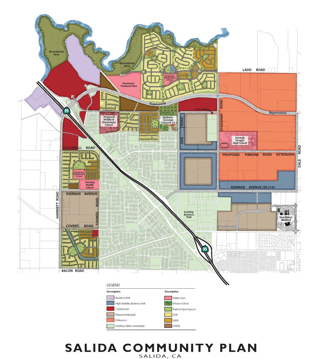
79 ILLUSTRATION
80 Planned Industrial. As part of an interjurisdictional effort, the County of Stanislaus and the City of Modesto developed the North Gateway Business Complex Master Development Plan in The goal of the plan is to help alleviate the existing jobs-housing imbalance in the County by promoting development of employment-generating industrial/business park uses in the area roughly bound by Ladd Road on the north, Dale Road on the east, Pelandale Expressway on the south, and Sisk Road on the west. The Planned Industrial designations shown to the east of Sisk Road within the Amendment Area are consistent with the intent of the North Gateway Business Complex Master Development Plan. Approximately 1,259 acres of land are designated as Planned Industrial. This represents approximately 37.2 percent of the Amendment Area. The majority of these lands are located in the northeastern portion of the Amendment Area. An area designated as Planned Industrial is located in the southwestern portion of the Amendment Area on land that includes an existing industrial use. Intended uses within the Planned Industrial designation are consistent with those defined in the General Plan. Business Park. The Community Plan includes 490 acres that are designated Business Park. This represents approximately 14.5 percent of the total Amendment Area. This use is concentrated largely in the eastern portion of the Amendment Area, but two notable areas in the northwest portion of the Amendment Area, near the Hammett Road/State Route 99 interchange, also carry this designation. The Business Park designation is intended to accommodate development of a full range of uses, including modern, employment-intensive uses. Principal development and employment-generating uses allowed within this designation include research, product development, professional office, commercial, and business services. Commercial. The Community Plan includes 280 acres of land designated Commercial within the Amendment Area. This represents approximately 8.3 percent of the Amendment Area. The Commercial designation applies to Regional Commercial, Neighborhood Commercial, and Highway Commercial uses as described in the General Plan. A major regional commercial area is planned in the northwest corner of the Amendment Area on the east side of State Route 99. Neighborhoodserving commercial uses are located at the southwest corner of the Covert Road/Toomes Road intersection and between Sisk Road and Stoddard Road just south of the planned expressway. New highway commercial uses are located west of State Route 99 near the Hammett Road/State Route 99 interchange. Table 2 SALIDA AMENDMENT AREA ANTICIPATED EMPLOYMENT GENERATION Land Use Acres Jobs/Acre 1 Total Jobs Business Park ,250 Manufacturing/Industrial/Warehousing, etc. 1, ,813 Neighborhood, General, and Highway Commercial ,720 Total 2, ,783 1 Source: Stanislaus County Economic and Workforce Alliance 2 Weighted average number of jobs per acre between Business Park and High-Visibility Business Park 1-80
81 Residential. The Amendment Area affords substantial opportunity for new residential development with a neighborhood orientation. The Amendment Area includes 866 acres of land designated Low- Density Residential, 187 acres designated Medium-Density Residential, and 57 acres designated Medium High-Density Residential, for a total of 1,110 acres of new residential development. Land designated for residential uses represents approximately 32.8 percent of the total Amendment Area. The new residential areas are generally located in the southwestern and northern portions of the Amendment Area. Public facilities, parks, and schools are conditional uses within areas designated as Low-Density Residential. Accordingly, approximately 118 acres of the land designated Low-Density Residential within the Amendment Area are either occupied by existing schools or owned by a school district for which a school is planned and are therefore not expected to result in additional units beyond the 5,000 units shown in Table 3. Additionally, 64 acres of land now owned by the Salida Sanitation District on which it operates the Salida Wastewater Treatment Plant are designated Low-Density Residential. Build-out of this land with residential uses may or may not occur. If the Salida Sanitation District determines that it will continue to operate the existing plant, modify the plant, and/or expand the plant in the future to meet its needs, this could preclude build-out of all 64 acres with residential units, though some portion of the land may retain capacity for residential development. As a result, the maximum number of units and the total projected population increase shown in Table 3 could be incrementally lower. Single-family homes at a density of up to eight dwelling units per net acre may be developed on land designated Low-Density Residential. The actual development density is likely to be about 4.5+/- dwelling units per net acre. Detached single-family homes, duplexes, and triplexes at densities of up to 14 units per net acre are permitted on land designated Medium-Density Residential. An average density of about 10+/- dwellings units per net acre is anticipated. Densities up to approximately 25 dwelling units per net acre are permitted on land designated Medium High- Density Residential. An average density of about 23+/- dwelling units per net acre is anticipated. Table 3, Projected Residential Build-Out and Population, shows that a total of approximately 5,000 new dwelling units could be accommodated within areas designated Low-, Medium- and Medium High-Density Residential use at build-out. The local population would increase by about 15,063 people with build-out of the residential designated portions of the Amendment Area. Including the population of the existing community, the projected total population within the Community Plan boundary would be 29,063 persons at build-out of the Amendment Area. Table 3 Projected Residential Build-Out and Population Land Use Designation Total Gross Acreage Average Dwelling Units Total Dwelling Units Population Accommodated 2 per Net Acre 1 Low-Density Residential ,754 8,299 Medium-Density Residential ,306 3,933 Medium High-Density Residential ,831 TOTAL 1,110 5,000 15, Net acreage is approximate based on an assumption that 30% of the gross acreage will be occupied by parks, roads, school sites, sidewalks, and utilities. 2. Based on average of 3.01 persons per household. 1-81
82 Agriculture. The County currently applies the Agriculture land use designation to areas identified as suitable for open space or recreational use. Within the Amendment Area, this designation applies solely to the proposed Stanislaus River Park, which comprises 244 acres, or approximately 7.2 percent of the Amendment Area. This designation is not intended to accommodate agricultural activities within the Community Plan boundary. The Stanislaus County Parks Development Plan states that regional parks are an important component of the County-wide parks program. The Stanislaus County Parks Development Plan suggests that parks which preserve river and riparian areas, which are significant natural resources, should be a focus. Though the Stanislaus County Parks Development Plan states that the overall acreage of existing regional parks in the County is adequate to serve future populations, to meet the intent of the Community Plan for providing expanded recreation resources and to help preserve valuable natural resources, the Amendment Area includes an approximately 244-acre river park along the Stanislaus River. The river park comprises lands within habitat and flood easements along the river that are controlled by the U.S. Army Corps of Engineers. The river park concept is to preserve and restore natural conditions close to the river and to locate passive recreational activities such as picnicking, bird-watching, walking, jogging, bicycling, and supporting structures such as restrooms and parking facilities, etc. at distances that are progressively farther from the river. Active recreational facilities could be considered. It is expected that developers of new projects within the Amendment Area would prepare a park plan, as part of the Development Plan process, for the river park and would fund improvements needed to implement the park plan. Circulation Circulation Concept. Existing and planned roadways should comprise a roadway network that serves the existing community and provides connectivity to regional transportation corridors. The existing circulation system and proposed circulation facilities and improvements should be fully integrated. Roadway segments and alignments should promote even dispersal of traffic throughout the Community Plan area. For example, industrial traffic should be routed from the eastern portion of the Amendment Area to a new expressway. Right-of-way for the Hammett Road interchange is needed to accommodate interchange improvements required to accommodate additional traffic generated by new development. A Project Study Report for the Hammett Road Interchange is currently under preparation. A Project Study Report shall be approved for the Hammett Road Interchange prior to approval of tentative maps and development permits for lands located within the interchange study area of the Project Study Report. Right-of-way for any interchange improvement is required to be protected and incorporated into any Development Plan for lands contained within the interchange study area. The new vehicular circulation system should include a number of major improvements: Construction of that portion of a new expressway located within the Amendment Area to facilitate traffic flow east to west and which connects to the State Route 99 / Hammett Road interchange; Modification of an existing State Route 99 interchange at Hammett Road; Extension of Pirrone Road east from Sisk Road; Widening and improvement of Sisk, Stoddard, Kiernan, Dale, Toomes, Hammett, and Bacon roads; 1-82
83 Facilitation of circulation to the area designated Planned Industrial that is located south of Kiernan Avenue; and Construction of local roadways and collectors throughout the Amendment Area to promote efficient and safe circulation. Conceptual Roadway Classifications/Sections. New roadways within the Amendment Area must be designed to accommodate a variety of vehicle types, volumes, speeds, and safety conditions. To this end, several roadway types are proposed. These range from an expressway road classification, where the proposed right-of-way width is up to 224 feet, to a local street classification with a right-of-way width of approximately 50 feet. Several of the roadway types incorporate Class II bicycle or Class I separated dual-use pedestrian/bicycle paths to provide for non-motorized transportation connectivity throughout the Amendment Area. In most cases, the conceptual sections differ from standard road sections utilized by the County and where different, the conceptual road standards are unique to the Amendment Area. Conceptual roadway classifications and types are as follows: Expressway: An expressway running east to west that connects the eastern portion of the Amendment Area and the communities of Oakdale, Riverbank, Modesto, and beyond with access to the State Route 99 / Hammett Road interchange is planned. The expressway would improve access to State Route 99 from the noted communities and link new development within the Amendment Area to the highway. New development within the Amendment Area is expected to provide funding needed to construct the portion of the expressway located within the Amendment Area. Funding to construct portions of the expressway that extend east from the eastern Amendment Area boundary must be acquired and improvements constructed by other parties. The expressway could ultimately be 10 lanes wide, with a right-of-way width of approximately 224 feet. The expressway would likely be constructed in phases and widened over time to respond to demand for increased capacity, as determined by traffic studies, and available funding. Hammett Road: The right-of-way width for Hammett Road north of Ciccarelli Road would measure 105 feet and would include 6 travel lanes (3 in each direction). A 12-foot Class I dual-use pedestrian/bicycle trail would be located within a 50-foot landscape buffer to the east. The total separation between new development and agriculture to the west of the Amendment Area would total 155 feet, inclusive of the landscape buffer. The right-of-way width for Hammett Road from Ciccarelli Road to Bacon would measure 81 feet and include 4 travel lanes (2 in each direction). A 12-foot Class I dual-use pedestrian/bicycle trail would be located within a 50-foot landscape buffer to the east. The total separation between new development and agriculture to its west inclusive of the right-of-way width and landscape buffer would be 131 feet. 4-Lane Backbone Roads: The following roadways are classified as 4-Lane Backbone Roads: Dale Road, Stoddard Road, Quinturn Lane and Pirrone Road. Right-of-way width for these road segments measures 125 feet and includes either an 8-foot Class I dual-use bike trail and sidewalk or a 6-foot Class II bike lane and 5-foot separated sidewalk on each side of the street. Sisk Road: Sisk Road would measure 110 feet in total public right-of-way width. The current public right-of-way width for Sisk Road totals 50 feet. New development would improve 60 feet of new right-of-way width on the eastern side of the street. 1-83
84 Kiernan Avenue Parkway: Kiernan Avenue west of Hwy. 99 from Hammett Road to the west property line of Salida Middle School would measure 81 feet in width and include 4 travel lanes. An 8-foot Class I dual-use bike trail and sidewalk would be located within a 31-foot landscape buffer to the south. Kiernan Avenue Parkway from the west property line of Salida Middle School to Toomes Road would measure 81 feet in width and include three travel lanes and a 5-foot separated sidewalk to the north. An 8-foot Class I dual-use pedestrian/bicycle trail would be located within a 31-foot landscape buffer. Bacon Road: Bacon Road right-of-way width would measure 72 feet and include four travel lanes and an 8-foot Class II dual-use bike path and sidewalk to the north. Arborwood Road: Arborwood Road right-of-way would measure 82 feet in width and include two travel lanes, a 5-foot Class II bike lane in each direction, and a 4-foot separated sidewalk on both sides of the street. Toomes, Ciccarelli, Covert, and Finney: Right-of-way for the named streets would measure 62 feet in width and include an 8-foot Class II bike lane, a 5-foot separated sidewalk on one side of the street, and an 8-foot Class I dual-use pedestrian/bicycle trail on one side of the street. Industrial Collectors: Right-of-way width for collector streets within land areas designated for planned industrial or business park land uses would total 80 feet and consist of 34 feet of travel lanes and a 6-foot attached sidewalk on each side of the centerline. Right-of-way width for local residential streets serving more than 50 homes would measure 56 feet and include a 5-foot separated sidewalk on both sides of the street. Right-of-way width for local residential streets serving fewer than 50 homes would measure 50 feet and include a 10-foot travel lane, an 8-foot parking lane, and a 4-foot attached sidewalk on each side of the street. The Development Plans for new development shall specify the roadway classifications and standards required within each Development Plan boundary to ensure that the overall circulation network functions efficiently and effectively. Development Plans may include modifications or additions to the conceptual road standards noted above, with such modifications and additions subject to review and approval of County staff. Neighborhood Parks and Trails Neighborhood Parks. Neighborhood parks are intended to serve residents within one-quarter to one-half mile, be within an appropriate walking or cycling distance, and be connected by a multi-use trail system where possible. The Stanislaus County Parks Development Plan suggests that neighborhood parks be provided at a ratio of at least three acres of park land for every 1,000 people. A population increase of 15,063 people is projected should the designated Low-Density, Medium-Density, and Medium High-Density new residential areas build-out within the Amendment Area to their maximum potential. If maximum build out were achieved, 45 acres of neighborhood parks would be needed to meet County standards. Satisfaction of park provision requirements may also be met through payment of park in-lieu fees. However, given the need for local park facilities within local neighborhoods in the Amendment Area, it is anticipated that park requirements will be largely met through provision of park land. The Community Plan illustrates the general location of potential neighborhood park sites. Where possible, neighborhood parks are placed adjacent to new or existing schools. Co-location of parks and school facilities maximizes the recreational utility of 1-84
85 both types of facilities; a full range of complementary recreational opportunities can be provided in one location. Neighborhood park land may also be designed to serve the dual-uses of recreation and temporary storm water detention. This approach improves land use efficiency. Trails. Community Plan policy requires that new development incorporate multi-use trails, pedestrian corridors, and bicycle facilities. Development Plans for new development must incorporate such improvements to demonstrate that new development is meeting the intent of the Community Plan that significant alternative transportation opportunities be provided to maximize community interconnectedness. Priority should be placed on linking neighborhoods with local neighborhood parks, the Stanislaus River Park, school facilities, and major employment centers. The Development Plans must include policy and guidance for the location and standards of trails, pedestrian facilities, and bicycle facilities. A regional trail spanning the length of the Stanislaus River Park is planned and would be a valuable asset. Class I or Class II bicycle lanes should be incorporated into the design of new arterial and major collector roadways. Separated dual-use Class I pedestrian/bicycle facilities should also be considered for inclusion in the design of such roadways. Schools With the increase in population in the Salida community, new schools will be needed to serve new local residents. It is anticipated that up to three new elementary schools and one new middle school will be required. The Community Plan shows the general locations proposed for new elementary school and middle school sites. These schools would complement the new Joseph Gregori High School, the Modesto Christian School, and the Salida Middle School, each of which is located within the Amendment Area. Each of the new schools is planned to include active recreational playfields and other amenities that will substantially expand availability of recreation facilities within the community. Public Utilities and Facilities New public services and facilities will be needed to support new development within the Amendment Area and may also provide benefit to the existing Salida community. Examples of new public utilities include wastewater treatment service and water service. Facilities include sheriff or fire stations, utility substations, or other utility improvements such as water or wastewater treatment facilities. While provisions have been made for the location of such facilities within the Amendment Area, the Board of Supervisors retains discretion to allow such facilities to be located outside the Amendment Area. Emergency Response. Emergency response and law enforcement services are provided by the Salida Fire Protection District and the Stanislaus County Sheriff s Department respectively. An additional fire station site may be needed to adequately serve emergency response needs of the community. A new fire station site has been generally designated for a location on Stoddard Road north of Pirrone Road as shown on the Community Plan. Final determination of a fire station site is within the purview of the Salida Fire Protection District and Stanislaus County. Wastewater Treatment. The existing Salida Wastewater Treatment Plant must be expanded or upgraded and/or a new plant constructed to provide treatment capacity for new development. The existing plant site is designated for residential use, but is considered a special treatment area within which continued operation and expansion of the plant is permitted. If an additional treatment plant is needed, it could be located nearly anywhere within the Amendment Area. New wastewater treatment plants can be designed to substantially reduce the types of nuisances normally 1-85
86 associated with more traditional facilities (i.e. odors, noise, etc.) and to be very land use efficient. A new plant with capacity to accommodate the new development could be constructed on about 8-12 acres of land. This enables flexibility in locating a new treatment facility because potential land use incompatibility concerns are substantially reduced. Given current requirements of the California Regional Water Quality Control Board, new wastewater treatment facilities must meet stringent environmental standards. Because water is a limited resource, it is likely that a new plant (and possibly any upgrade to the existing wastewater treatment plant) would be designed to treat wastewater to a tertiary level. A significant volume of recycled water will be produced. Recycled water may be used for a variety of applications such as landscape irrigation, toilet flushing, etc. Use of recycled water would reduce demand for ground or surface water, thereby reducing the impact of new development on existing water sources. The precise location of a new wastewater treatment facility, if one is needed, will be identified and incorporated into the Development Plan which guides development for that location. The Development Plan must address land use compatibility issues and identify measures to avoid or substantially reduce incompatibilities should incompatibilities be identified. Water Supply. An adequate water supply must be secured and demonstrated for development in accordance with applicable law. WESTLEY COMMUNITY PLAN Westley could experience significant growth in the coming years. Projected population within the Community Services District by the year 2010 is 740. The sewage treatment facility can serve an approximate capacity of However, until a public water system is available, growth will be kept to a minimum. Existing Williamson Act contracts will restrict the expansion of the current district boundary. 1-86
87 1-87

88 1-88

89 1-89
90 1-90

91 1-91
92 1-92
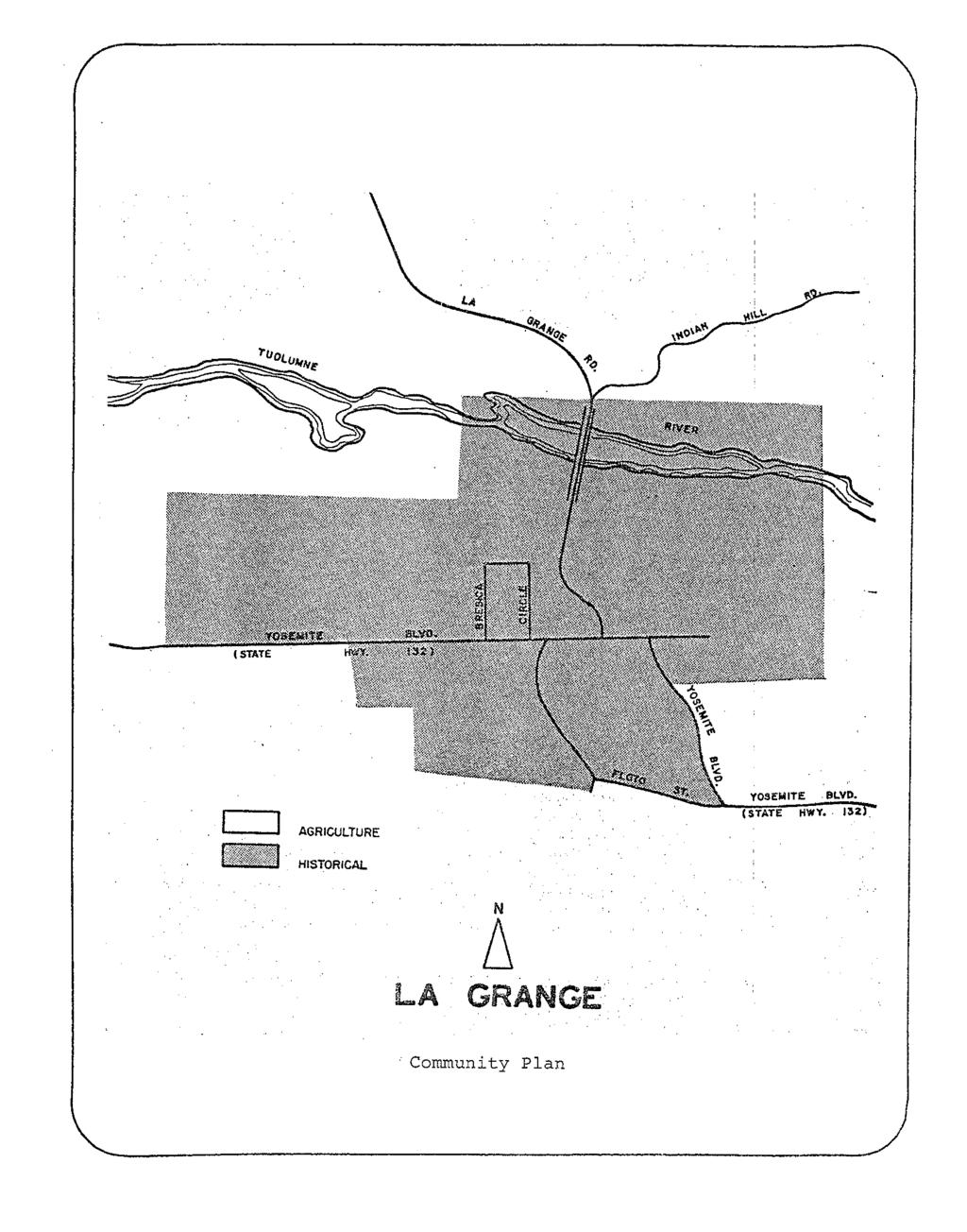
93 1-93
CHAPTER 12 IMPLEMENTATION
 CHAPTER 12 IMPLEMENTATION The 2010 Town of Denton Comprehensive Plan is intended to capture a vision of the future of Denton. As such, it provides a basis for a wide variety of public and private actions
Glenborough at Easton Land Use Master Plan
 Implementation 114 9.0 IMPLEMENTATION 9.1 OVERVIEW This chapter summarizes the administrative procedures necessary to implement the proposed land use plan, infrastructure improvements, development standards,
NEW CASTLE COUNTY S ZONING DISTRICTS
 NEW CASTLE COUNTY S ZONING DISTRICTS This is general information about New Castle County s zoning districts. The information included is by no means exhaustive or complete. Before designing plans to develop
Dwelling Units Max 12 dwelling units per acre/min 8 dwelling units per acre. Development Mix 80% non residential/20% residential
 13. OSTEEN LOCAL PLAN Background: The Osteen Local Plan area is located in southwest Volusia County along the SR 415 corridor between Lemon Bluff Road and Acorn Lake Road and includes 3,990 acres. The
GENERAL LAND USE POLICIES
 GENERAL LAND USE POLICIES The County will: GOALS AND OBJECTIVES 7.1 Fiscal Distribute the designation of land uses to balance the costs of providing public services and facilities with generating public
Venice Pumping Plant Dual Force Main Project Draft EIR
 City of Los Angeles 5.9 LAND USE PLANS 5.9.1 Environmental Setting Venice Pumping Plant Dual Force Main Project Draft EIR The Project lies within the bounds of Los Angeles County and the City of Los Angeles.
LU Encourage schools, institutions, and other community facilities that serve rural residents to locate in neighboring cities and towns.
 Application No. 891627: Comprehensive Plan Text Amendment - Rural School Policies - Amend policies consistent with State Legislation allowing schools in the rural area and extension of sewer service to
Woodburn Comprehensive Plan Growth Management Goals and Policies
 Goal Woodburn Comprehensive Plan Growth Management Goals and Policies G-1. The City's goal is to manage growth in a balanced, orderly and efficient manner, consistent with the City s coordinated population
Planned Development Review Revisions (Project No. PLNPCM )
") Planned Development Review Revisions (Project No. PLNPCM2014-00139) Standard residential development Planned Development Example: Smaller lot sizes than what is allowed to create open space amenity. What
Planned Development Review Revisions (Project No. PLNPCM2014-00139) Standard residential development Planned Development Example: Smaller lot sizes than what is allowed to create open space amenity. What
ALBEMARLE COUNTY CODE CHAPTER 18 ZONING SECTION 20A NEIGHBORHOOD MODEL - NMD
 CHAPTER 18 ZONING SECTION 20A NEIGHBORHOOD MODEL - NMD Sections: 20A.1 PURPOSE AND INTENT 20A.2 STATUS AS A PLANNED DEVELOPMENT DISTRICT 20A.5 CODES OF DEVELOPMENT 20A.6 PERMITTED USES 20A.7 RESIDENTIAL
AWH REPORT OF THE PLANNING AND DEVELOPMENT DEPARTMENT FOR APPLICATION FOR REZONING ORDINANCE TO PLANNED UNIT DEVELOPMENT
 AWH REPORT OF THE PLANNING AND DEVELOPMENT DEPARTMENT FOR APPLICATION FOR REZONING ORDINANCE TO PLANNED UNIT DEVELOPMENT MAY 8, 2014 The Planning and Development Department hereby forwards to the Planning
Rural Land Use Designations Kittitas County December 6, 2007 Draft
 KITTITAS COUNTY COMMUNITY DEVELOPMENT SERVICES 411 N. Ruby St., Suite 2, Ellensburg, WA 98926 CDS@CO.KITTITAS.WA.US Office (509) 962-7506 Fax (509) 962-7682 Rural Land Use Designations Kittitas County
COLVER ROAD INDUSTRIAL CONCEPT PLAN
 COLVER ROAD INDUSTRIAL CONCEPT PLAN A CONCEPTUAL LAND USE AND TRANSPORTATION PLAN FOR TA-4 AN URBAN RESERVE AREA OF THE CITY TALENT City of Talent Adopted by City Council Resolution No., June, 2015 PART
3.10 LAND USE SETTING PROJECT SITE EXISTING LAND USE DESIGNATIONS AND ZONING. General Plan Land Use Designations.
 This section of the Draft EIR addresses the existing land uses on and adjacent to the project site and discusses the potential impacts of the proposed project on existing land uses. Key issues addressed
CONSERVATION/OPEN SPACE ELEMENT
 Chapter Three CONSERVATION/OPEN SPACE ELEMENT INTRODUCTION The Conservation/Open Space Element of the Stanislaus County General Plan emphasizes the conservation and management of natural resources and
A. WHAT IS A GENERAL PLAN?
 I. Introduction A. WHAT IS A GENERAL PLAN? A general plan is the planning guideline for the future of a city. It contains goals and policies which regulate urban development, the protection of the natural
Palmdale Municipal Code (Excerpts) Title 14: ENVIRONMENTAL MANAGEMENT Chapter 14.04: JOSHUA TREE AND NATIVE DESERT VEGETATION PRESERVATION
 Title 14: ENVIRONMENTAL MANAGEMENT Chapter 14.04: JOSHUA TREE AND NATIVE DESERT VEGETATION PRESERVATION") Palmdale Municipal Code (Excerpts) Title 14: ENVIRONMENTAL MANAGEMENT Chapter 14.04: JOSHUA TREE AND NATIVE DESERT VEGETATION PRESERVATION 14.04.010 Purpose and intent. It is determined by the City Council
Palmdale Municipal Code (Excerpts) Title 14: ENVIRONMENTAL MANAGEMENT Chapter 14.04: JOSHUA TREE AND NATIVE DESERT VEGETATION PRESERVATION 14.04.010 Purpose and intent. It is determined by the City Council
SAN RAFAEL GENERAL PLAN 2040 INTRODUCTION AND OVERVIEW
 SAN RAFAEL GENERAL PLAN 2040 INTRODUCTION AND OVERVIEW Steering Committee Presentation February 14, 2018 Purpose of General Plan Guide land use and development decisions Coordinate transportation, infrastructure,
DISCUSSION ON VACAVILLE S2 INVESTORS PROPERTY IN URBAN RESERVE
 Agenda Item No. 9C April 25, 2017 TO: FROM: SUBJECT: Honorable Mayor and City Council Attention: Jeremy Craig, Interim City Manager Barton Brierley, AICP, Community Development Director (Staff Contact:
CHAPTER SPECIAL PURPOSE AND OVERLAY ZONING DISTRICTS
 Special Purpose and Overlay Zoning Districts 106.28.010 CHAPTER 106.28 - SPECIAL PURPOSE AND OVERLAY ZONING DISTRICTS SPECIAL PURPOSE AND OVERLAY ZONING DISTRICTS Sections: 106.28.010 - Purpose 106.28.020
Urban Planning and Land Use
 Urban Planning and Land Use 701 North 7 th Street, Room 423 Phone: (913) 573-5750 Kansas City, Kansas 66101 Fax: (913) 573-5796 Email: planninginfo@wycokck.org www.wycokck.org/planning To: From: City Planning
RECREATION AND OPEN SPACE ELEMENT GOALS, OBJECTIVES, AND POLICIES
 RECREATION AND OPEN SPACE ELEMENT GOALS, OBJECTIVES, AND POLICIES Goal 7 To provide park facilities, recreation programs, and open space resources that are safe, adequate, and accessible to all City residents,
CHAPTER 2: PLANNING PRINCIPLES
 CHAPTER 2: PLANNING PRINCIPLES 2 Comprehensive Principles The following overarching Principles provide the basis for the goals and policies included in the Mendocino County General Plan. These Principles
Land Use Amendment in Southwood (Ward 11) at and Elbow Drive SW, LOC
 at and Elbow Drive SW, LOC") 2018 November 15 Page 1 of 10 EXECUTIVE SUMMARY This land use amendment application was submitted by Rick Balbi Architect on 2017 August 31 on behalf of Sable Developments Ltd, and with authorization from
2018 November 15 Page 1 of 10 EXECUTIVE SUMMARY This land use amendment application was submitted by Rick Balbi Architect on 2017 August 31 on behalf of Sable Developments Ltd, and with authorization from
and services The protection and conservation of environmentally significant and sensitive natural heritage features and functions.
 6. Land Use 6.0 Preamble A healthy and livable city is one in which people can enjoy a vibrant economy and a sustainable healthy environment in safe, caring and diverse neighbourhoods. In order to ensure
ORDINANCE WHEREAS, this Ordinance is consistent with the City of Winter Garden Comprehensive Plan; and
 ORDINANCE 17-06 AN ORDINANCE OF THE CITY COMMISSION OF THE CITY OF WINTER GARDEN, FLORIDA, CREATING ARTICLE XIV OF CHAPTER 118 OF THE CITY OF WINTER GARDEN CODE OF ORDINANCES PROVIDING FOR THE EAST PLANT
Appendix I-A8 SALIDA COMMUNITY PLAN
 Appendix I-A8 SALIDA COMMUNITY PLAN Adopted by the Stanislaus County Board of Supervisors AUGUST 7, 2007 *A technical update clarifying the integration of the 2007 Salida Area Planning, Road Improvement,
LAND USE ELEMENT. Purpose. General Goals & Policies
 LAND USE ELEMENT Purpose This Land Use Element contains the goals and policies necessary to support the City s responsibility for managing land resources and guiding development through implementing regulations,
SECTION E. Realizing the Plan
 SECTION E Realizing the Plan 60 DESIGN REGINA - OFFICIAL COMMUNITY PLAN SECTION E Realizing the Plan Design Regina has been an ambitious plan-making exercise, with a high level of community, stakeholder,
The Maryland-National Capital Park and Planning Commission Prince George's County Planning Department Development Review Division
 The Maryland-National Capital Park and Planning Commission Prince George's County Planning Department Development Review Division 301-952-3530 Note: Staff reports can be accessed at www.mncppc.org/pgco/planning/plan.htm.
Planning & Zoning Commission Staff Report
 Planning & Zoning Commission Staff Report Meeting Date: May 26, 2015 Drafted by: Katherine Harrison-Rogers CASE # Z2886 PROJECT NAME: APPLICANT/ REPRESENTATIVE: Shawna Runyan PROPERTY OWNER: 1840 (previously
Staff Report and Recommendation
 Community Planning and Development Planning Services 201 W. Colfax Ave., Dept. 205 Denver, CO 80202 p: 720.865.2915 f: 720.865.3052 www.denvergov.org/cpd TO: City Council Neighborhoods and Planning Committee
12 January 12, 2011 Public Hearing APPLICANT: TAILWIND DEVELOPMENT GROUP,LLC PROPERTY OWNER: CITY OF VIRGINIA BEACH
 12 January 12, 2011 Public Hearing APPLICANT: TAILWIND DEVELOPMENT GROUP,LLC PROPERTY OWNER: CITY OF VIRGINIA BEACH STAFF PLANNER: Faith Christie REQUEST: Conditional Change of Zoning (from PD-H1 Planned
Planning Commission Staff Report June 5, 2008
 Owner/Applicant Taylor Village Sacramento Investments Partners, LP c/o Kim Whitney 1792 Tribute Road #270 Sacramento, CA 95815 Staff Recommendation Planning Commission Staff Report Project: File: Request:
R E S O L U T I O N. Single-Family Residence/ Church. 2,488 sq. ft. 2,488 sq. ft. Area Parking Required: Church
 R E S O L U T I O N WHEREAS, the Prince George s County Planning Board is charged with the approval of Detailed Site Plans pursuant to Part 3, Division 9 of the Zoning Ordinance of the Prince George s
HAMLET OF KINGMAN AREA STRUCTURE PLAN
 HAMLET OF KINGMAN AREA STRUCTURE PLAN Prepared by: Austrom Consulting Ltd. Page 1 of 19 Table of Contents TABLE OF CONTENTS... 2 1. BACKGROUND... 3 1.1 PLAN AREA... 3 1.2 PLAN PURPOSE... 3 1.3 LEGISLATIVE
TREASURE COAST REGIONAL PLANNING COUNCIL M E M O R A N D U M. To: Council Members AGENDA ITEM 5H
 TREASURE COAST REGIONAL PLANNING COUNCIL M E M O R A N D U M To: Council Members AGENDA ITEM 5H From: Date: Subject: Staff October 17, 2008 Council Meeting Local Government Comprehensive Plan Review Draft
Official Plan Review
 Official Plan Review Summary Report - The Built Environment August 2014 Part 1: Introduction Planning for a healthy, prosperous and sustainable community is an important goal for our municipality. From
Ridgefield and the Growth Management Act
 1 2 Ridgefield and the Growth Management Act 3 Why Do We Plan History of Planning in Ridgefield Washington experiences rapid growth in the late 1980 s that began to change the perceived quality of life.
Vision Statement for the Town of Flower Mound Master Plan The Town of Flower Mound Master Plan furthers the established community based vision to:
 Vision Statement for the The furthers the established community based vision to: Preserve the country atmosphere and natural environment that makes Flower Mound a unique and desirable community; Mitigate
ROAD CLOSURE AND LAND USE AMENDMENT SILVER SPRINGS (WARD 1) NORTHEAST OF NOSEHILL DRIVE NW AND SILVER SPRINGS ROAD NW BYLAWS 2C2018 AND 29D2018
 NORTHEAST OF NOSEHILL DRIVE NW AND SILVER SPRINGS ROAD NW BYLAWS 2C2018 AND 29D2018") Page 1 of 19 EXECUTIVE SUMMARY This application proposes redesignating two parcels in the community of Silver Springs from Special Purpose Future Urban Development (S-FUD) District and undesignated road
Page 1 of 19 EXECUTIVE SUMMARY This application proposes redesignating two parcels in the community of Silver Springs from Special Purpose Future Urban Development (S-FUD) District and undesignated road
THE CITY OF VAUGHAN BY-LAW BY-LAW NUMBER
 THE CITY OF VAUGHAN BY-LAW BY-LAW NUMBER 123-2013 A By-law to designate the whole of the City of Vaughan as a Site Plan Control Area, and to adopt site development guidelines and rules of procedure for
PLANNING COMMISSION. Agenda Item # 3.
 PLANNING COMMISSION Agenda Item # 3. CASE SUMMARY Conditional District Rezoning Planning Commission February 4, 2015 CD-9-215 Jeff Walton, 341-3260, jeff.walton@wilmingtonnc.gov Staff recommendation CONDITIONAL
City Of Sparks Planning Commission Item
 Page 1 of 12 City Of Sparks Planning Commission Item Meeting Date: May17, 2012 Subject: PCN12009, Public Hearing, Consideration and possible action on a Master Plan Amendment and Rezoning request to change
TREASURE COAST REGIONAL PLANNING COUNCIL M E M O R A N D U M. To: Council Members AGENDA ITEM 5I
 TREASURE COAST REGIONAL PLANNING COUNCIL M E M O R A N D U M To: Council Members AGENDA ITEM 5I From: Date: Subject: Staff December 12, 2008 Council Meeting Local Government Comprehensive Plan Review Town
A BILL FOR AN ORDINANCE TO AMEND CHAPTER 9, KAUAI COUNTY CODE 1987, RELATING TO STREET REQUIRE:MENTS FOR SUBDIVISIONS
 ORDINANCE NO. BILL NO. { vy"yj1j A BILL FOR AN ORDINANCE TO AMEND CHAPTER 9, KAUAI COUNTY CODE 1987, RELATING TO STREET REQUIRE:MENTS FOR SUBDIVISIONS BE IT ORDAINED BY THE COUNCIL OF THE COUNTY OF KAUA'I,
RESOLUTION NO: WHEREAS, the subject property has a Public, Semi-Public (PS) zoning designation and a General Plan designation of Institutional; and
 zoning designation and a General Plan designation of Institutional; and") RESOLUTION NO: A RESOLUTION OF THE CITY COUNCIL OF THE CITY OF PASADENA APPROVING A 14-YEAR, EIGHT-PHASE MASTER PLAN AMENDMENT FOR HUNTINGTON MEMORIAL HOSPITAL LOCATED AT 100 WEST CALIFORNIA BOULEVARD
RESOLUTION NO: A RESOLUTION OF THE CITY COUNCIL OF THE CITY OF PASADENA APPROVING A 14-YEAR, EIGHT-PHASE MASTER PLAN AMENDMENT FOR HUNTINGTON MEMORIAL HOSPITAL LOCATED AT 100 WEST CALIFORNIA BOULEVARD
ARTICLE IX SPECIAL PERMIT USES
 ARTICLE IX SPECIAL PERMIT USES All special permit uses cited in Article IX and Attachment A of this Ordinance or any other Section of this Ordinance shall be subject to Site Plan Review. The procedures
Baumgarten MPUD. Exhibit 3 Evaluation Criteria
 Pursuant to LDC subsections 10.02.13 B, 10.02.08 F and Chapter 3 G. of the Administrative Code, staff s analysis and recommendation to the Planning Commission, and the Planning Commission s recommendation
CHAPTER 7: Transportation, Mobility and Circulation
 AGLE AREA COMMUNITY Plan CHAPTER 7 CHAPTER 7: Transportation, Mobility and Circulation Transportation, Mobility and Circulation The purpose of the Transportation, Mobility and Circulation Chapter is to
TOWN OF BRUDERHEIM Report to the capital region board
 TOWN OF BRUDERHEIM Report to the capital region board Introduction to the Town of Bruderheim Municipal Development Plan amendment and Relation to the CRB Evaluation Criteria 02 march 2017 1 Introduction
General Location Annex, Rezone & Preliminary Plat Lansdowne Addition, Unit Three
 NEWFOUNDLAND I-5 Agricultural District Subject Site SUNDANCE ANDERSON Single Family Residential CHRISTY PUD Agricultural District Highway Business General Location Annex, Rezone & Preliminary Plat Lansdowne
CITY OF CYPRESS 5275 Orange Avenue Cypress, California (714) DESIGN REVIEW COMMITTEE PERMIT PROCESS
 DESIGN REVIEW COMMITTEE PERMIT PROCESS") CITY OF CYPRESS 5275 Orange Avenue Cypress, California 90630 (714) 229-6720 DESIGN REVIEW COMMITTEE PERMIT PROCESS 1. Discuss project with Planning staff to determine zoning regulations, any unusual characteristics
CITY OF CYPRESS 5275 Orange Avenue Cypress, California 90630 (714) 229-6720 DESIGN REVIEW COMMITTEE PERMIT PROCESS 1. Discuss project with Planning staff to determine zoning regulations, any unusual characteristics
AREASTRUCTURE PLAN AMENDMENT COCHRANE NORTH
 AREASTRUCTURE PLAN AMENDMENT COCHRANE NORTH In order to implement the vision outlined in the Conceptual Scheme, the following three amendments to the Cochrane North ASP are proposed: 1. Allow commercial
PSRC REVIEW REPORT & CERTIFICATION RECOMMENDATION
 PSRC REVIEW REPORT & CERTIFICATION RECOMMENDATION KITSAP COUNTY COUNTYWIDE PLANNING POLICIES July 2, 2012 BACKGROUND A major emphasis of the Washington State Growth Management Act (GMA) is the need to
OFFICE CONSOLIDATION SECONDARY PLAN AREA 22 THE BRAMALEA SOUTH INDUSTRIAL SECONDARY PLAN
 OFFICE CONSOLIDATION SECONDARY PLAN AREA 22 THE BRAMALEA SOUTH INDUSTRIAL SECONDARY PLAN November 2010 EXPLANATORY NOTES (Secondary Plan Area 22) General (pertaining to all secondary plan office consolidations)
Joint Study Session of the Sutter County. March 2, 2009
 Joint Study Session of the Sutter County Board of Supervisors and Planning Commission March 2, 2009 CURRENT APPLICATION General Plan Amendment Specific Plan Specific Plan Appendices Utility Plans Transit/AQ
Parks, Trails, and Open space Element
 Parks, Trails, and Open space Element Parks, Trails, and Open Space element Parks, Recreation, and Open Space are important components of the quality of life desired by the residents of Elk Grove. This
Subject: Hendry County Evaluation and Appraisal Report Letter of Understanding - Identification of Major Issues
 HENDRY COUNTY PLANNING & ZONING DEPARTMENT POST OFFICE BOX 2340 165 S. LEE STREET LABELLE, FLORIDA 33975 (863) 675-5240 FAX: (863) 675-5317 SUNCOM 744-4750 November 16, 2007 Mr. Mike McDaniel, Chief Office
Intergovermental Coordination
 Intergovermental Coordination CITY OF WINTER PARK CHAPTER 8: INTERGOVERNMENTAL COORDINATION ELEMENT INTERGOVERNMENTAL COORDINATION ELEMENT GOAL 8-1: PROVIDE FOR IMPROVED INTERGOVERNMENTAL COORDINATION
Parks, Trails, and Open Space Element
 P arks, Recreation, and Open Space are important components of the quality of life desired by the residents of Elk Grove. This Element of the General Plan addresses the City s goals, policies, and actions
EXECUTIVE SUMMARY DRAFT CHAPTER 1 INTRODUCTION EXECUTIVE SUMMARY
 CHAPTER 1 EXECUTIVE SUMMARY INTRODUCTION Through the joint efforts of the City of Tulsa planning staff and the Land Services division of Indian Nations Council of Governments (INCOG), the Berryhill Land
LAND USE GOALS, OBJECTIVES AND POLICIES. Goal 1: [L] (EFF. 7/16/90)
![LAND USE GOALS, OBJECTIVES AND POLICIES. Goal 1: [L] (EFF. 7/16/90)](/thumbs/88/115018937.jpg "LAND USE GOALS, OBJECTIVES AND POLICIES. Goal 1: [L] (EFF. 7/16/90)") LAND USE GOALS, OBJECTIVES AND POLICIES Goal 1: [L] (EFF. 7/16/90) The Comprehensive Plan shall protect and enhance the quality of life in this community by providing economically sound educational, employment,
LAND USE GOALS, OBJECTIVES AND POLICIES Goal 1: [L] (EFF. 7/16/90) The Comprehensive Plan shall protect and enhance the quality of life in this community by providing economically sound educational, employment,
PLANNED DEVELOPMENT (MASTER PLAN & UNIT PLAN)
") Central Permit Center 555 Santa Clara Street Vallejo CA 94590 Business License Building Fire Prevention Planning Public Works 707.648.4310 707.648.4374 707.648.4565 707.648.4326 707.651.7151 PLANNED DEVELOPMENT
Central Permit Center 555 Santa Clara Street Vallejo CA 94590 Business License Building Fire Prevention Planning Public Works 707.648.4310 707.648.4374 707.648.4565 707.648.4326 707.651.7151 PLANNED DEVELOPMENT
EXHIBIT A. Tax Increment Reinvestment Zone No. 1 (Town Center) First Amended Project Plan 1
 First Amended Project Plan 1") EXHIBIT A Tax Increment Reinvestment Zone No. 1 (Town Center) First Amended Project Plan 1 1 As amended by Resolution No. 2008-02-001(TR1R) of the Tax Increment Reinvestment Zone No.1, and approved to
EXHIBIT A Tax Increment Reinvestment Zone No. 1 (Town Center) First Amended Project Plan 1 1 As amended by Resolution No. 2008-02-001(TR1R) of the Tax Increment Reinvestment Zone No.1, and approved to
COMMISSION ACTION FORM
 ITEM #: 6 DATE: 09-06-17 COMMISSION ACTION FORM REQUEST: Introduction and Initial Review of Proposed Amendments to the Ames Urban Fringe Future Land Map for the North Growth Gap Area BACKGROUND INFORMATION:
PLANNING REPORT CITY OF EAGAN. APPLICANT: Cedar Grove Hospitality, LLC HEARING DATE: December 18, 2014
 PLANNING REPORT CITY OF EAGAN REPORT DATE: December 8, 2014 CASE: 19-PA-11-11-14 APPLICANT: Cedar Grove Hospitality, LLC HEARING DATE: PROPERTY OWNER: The Flats at Cedar APPLICATION DATE: Nov. 21, 2014
Planning Commission April 4, 2013 BOCC Workshop Page 1
 Planning Commission April 4, 2013 BOCC Workshop Page 1 Planning Commission April 4, 2013 BOCC Workshop Page 2 Planning Commission April 4, 2013 BOCC Workshop Page 3 Planning Commission April 4, 2013 BOCC
SONOMA LOCAL AGENCY FORMATION COMMISSION
 For accessibility assistance with any of the following documents, please contact Sonoma LAFCO at (707) 565-2577 or email us at cynthia.olson@sonoma-county.org. SONOMA LOCAL AGENCY FORMATION COMMISSION
ARTICLE 6: Special and Planned Development Districts
 ARTICLE 6: Special and Planned Development Districts 6-10 Traditional Neighborhood Development (TND) District 6-10.10 Purpose and Intent The Traditional Neighborhood Development (TND) District provides
CHAPTER 3 VISION, GOALS, & PLANNING PRINCIPLES. City of Greensburg Comprehensive Plan. Introduction. Vision Statement. Growth Management Goals.
 CHAPTER 3 VISION, GOALS, & PLANNING PRINCIPLES Introduction The Greensburg Comprehensive Plan is intended as a working community document. A combination of long and short-term goals, this document is intended
2016 Comprehensive Plan Amendments C OMPREHENSIVE P LAN T EXT AND M AP A MENDMENT
 2016 Comprehensive Plan Amendments T EXT A MENDMENTS D ISTILLERIES IN R URAL P OLICIES #844110 LID POLICIES #844112 M AP A MENDMENTS B ETHEL S CHOOL D ISTRICT #844237 P ARKS AND R ECREATION #844305 C OMPREHENSIVE
CHESAPEAKE LANDSCAPE ORDINANCE
 CHESAPEAKE LANDSCAPE ORDINANCE CONSERVATION PRESERVATION CZO 19-600 Effective October 16, 2008 BUFFER YARD C PARKING LOT REFORESTATION YEAR 1 REFORESTATION YEAR 4 BUFFER YARD F CBPA REFORESTATION Page
CITY OF PUYALLUP. Background. Development Services
 CITY OF PUYALLUP Development Services 333 South Meridian Puyallup WA 98371 To: City Council From: Katie Baker, AICP, Planning Division Re: South Hill Neighborhood Plan Adoption Date: (Meeting date: February
ADMINISTRATIVE REPORT
 ADMINISTRATIVE REPORT TO: FROM: Board of Directors B. Newell, Chief Administrative Officer DATE: July 6, 2017 RE: Official Community Plan (OCP) Bylaw Amendment Electoral Area C Administrative Recommendation:
The transportation system in a community is an
 7 TRANSPORTATION The transportation system in a community is an important factor contributing to the quality of life of the residents. Without a sound transportation system to bring both goods and patrons
Land Use element LAND USE POLICY AREAS ESTATE AND RURAL RESIDENTIAL AREAS/RURAL SHELDON AREA OLD TOWN ELK GROVE
 Land Use element Land Use is often considered the heart of the General Plan. The statement of future land uses describes how the City believes it should develop in the future where housing, shopping, open
S A C R A M E N T O C O U N T Y JACKSON HIGHWAY & GRANT LINE EAST VISIONING STUDY
 JACKSON HIGHWAY & GRANT LINE EAST S A C R A M E N T O C O U N T Y P L A N N I N G D E P A R T M E N T SUMMARY AND WORKBOOK November 19, 2008 History of the Visioning Study Sacramento County has two growth
CHAPTER 4 - LAND USE CLASSIFICATIONS
 CHAPTER 4 - LAND USE CLASSIFICATIONS Four new land use classification categories are established in the Gualala Town Plan: Gualala Village Mixed Use; Gualala Highway Mixed Use; Gualala Planned Development
COUNTY OF RIVERSIDE PLANNING DEPARTMENT STAFF REPORT
 Agenda Item No.: 5.4 Area Map: Jurupa Zoning District: Prado-Mira Loma Supervisorial District: Second Project Planner: Christian Hinojosa Planning Commission: February 3, 2010 Conditional Use Permit No.
PORT WHITBY COMMUNITY
 PORT WHITBY COMMUNITY SECONDARY PLAN UPDATE COMMUNITY IMPROVEMENT PLAN URBAN DESIGN GUIDELINES September 2015 DRAFT PROPOSED AMENDMENT NUMBER # to the Whitby Official Plan PURPOSE: The intent of this Amendment
City Center Specific Plan Amendments And Background Report City of Richmond. PLANNING COMMISION FINAL DRAFT January, 2001
 City Center Specific Plan Amendments And Background Report City of Richmond PLANNING COMMISION FINAL DRAFT January, 2001 TABLE OF CONTENTS Page LIST OF TABLES... LIST OF FIGURES... INDEX... OVERVIEW...
A Growing Community Rural Settlement Areas
 Town of Huntsville Official Plan Review - POLICY BACKGROUND PAPER A Growing Community Rural Settlement Areas BACKGROUND: In addition to the fully municipally-serviced Urban Settlement Area and the Hidden
Mobility Districts and Traffic Studies
 Mobility Districts and Traffic Studies During the last Comprehensive Plan update in 2008, the City of Sarasota identified the need to develop a citywide strategy for enhancing the mobility options of all
Narcoossee Roadway Corridor
 Community Meeting Narcoossee Roadway Corridor April 5, 2012 Meeting Agenda Purpose of Meeting Continuation of Study Update Process (Previous Meetings Oct. & Nov., 2011) Tonight s Objective Review Proposals
ARTICLE V PLANNED UNIT DEVELOPMENT DISTRICT
 ARTICLE V PLANNED UNIT DEVELOPMENT DISTRICT A. Purpose and Objective The Planned Unit Development (PUD) procedure provides a flexible land use and design regulation through the use of performance criteria
Applicant Name Phone / Fax / Address City State Zip Code . Property Owner Phone / Fax / Address City State Zip Code
 Master Development Plan Application Community Development Department City of Redmond 411 SW 9 th Street Redmond, Oregon 97756 541-923-7721 541-548-0706 FAX Master Development Plan Fee $38,862.52 File Number
Town of Portola Valley General Plan. Nathhorst Triangle Area Plan
 Town of Portola Valley General Plan Amended December 10, 1997 Table of Contents Introduction... 1 Planning Area... 1 Objectives... 2 Principles... 2 Standards... 4 Description... 4 Community Commercial...
The Town Board of the Town of Vienna, County of Dane, State of Wisconsin, does ordain and adopt as follows.
 ORDINANCE DRIVEWAYS AND CULVERTS NO. 6-5-06 ORDINANCE CONCERNING DRIVEWAY AND CULVERT REQUIREMENTS 1-1-1 Driveway Permits; Culvert Requirements 1-1-2 Driveway and Culvert Location, Design and Construction
PLANNED UNIT DEVELOPMENT & SUBDIVISION STAFF REPORT Date: May 18, 2017
 & PUD-0000102-2017 PLANNED UNIT DEVELOPMENT & SUBDIVISION STAFF REPORT Date: May 18, 2017 NAME SUBDIVISION NAME Dauphin Creek Estates Subdivision Dauphin Creek Estates Subdivision LOCATION CITY COUNCIL
4.1.3 LAND USE CATEGORIES
 4.1.3 LAND USE CATEGORIES a. City Center District The City Center District incorporates the existing character and mix of uses in downtown Belmont to encourage redevelopment and new development in keeping
Chapter 1: General Program Information
 Chapter 1: General Program Information 1.1 Introduction The Montgomery County Stormwater Management Resolution (#03-1-5) was adopted by the County Board of Commissioners on January 22, 2003. The purpose
LAND USE AMENDMENT DOWNTOWN COMMERCIAL CORE (WARD 7) MACLEOD TRAIL SE AND 5 AVENUE SE BYLAW 254D2017
 MACLEOD TRAIL SE AND 5 AVENUE SE BYLAW 254D2017") Page 1 of 10 EXECUTIVE SUMMARY This Land Use Amendment application seeks to redesignate a full downtown block (currently the YWCA site) from a Direct Control based on the CM-2 District (Land Use Bylaw
Page 1 of 10 EXECUTIVE SUMMARY This Land Use Amendment application seeks to redesignate a full downtown block (currently the YWCA site) from a Direct Control based on the CM-2 District (Land Use Bylaw
Chapter Master Planned Communities (MPC) District
 District") Sections 14.53.010 Purpose and Intent 14.53.020 Applicability 14.53.030 Procedure 14.53.040 MPC Standards 14.53.050 Required Findings 14.53.010 Purpose and Intent Chapter 14.53 Master Planned Communities
Sections 14.53.010 Purpose and Intent 14.53.020 Applicability 14.53.030 Procedure 14.53.040 MPC Standards 14.53.050 Required Findings 14.53.010 Purpose and Intent Chapter 14.53 Master Planned Communities
6 PORT SYDNEY SETTLEMENT AREA
 Section 6 Port Sydney Page 61 6 PORT SYDNEY SETTLEMENT AREA 6.1 Basis and Principles Village of Port Sydney Waterfront Community Existing Services 6.1.1 Port Sydney is an historic settlement that has developed
Chapter 1 - General Design Guidelines CHAPTER 1 GENERAL DESIGN GUIDELINES
 CHAPTER 1 GENERAL DESIGN GUIDELINES 1.0 INTRODUCTION This Publication has been developed to provide current, uniform procedures and guidelines for the application and design of safe, convenient, efficient
BYLAW C A Bylaw of Rocky View County to amend Land Use Bylaw C
 BYLAW C-7720-2017 A Bylaw of Rocky View County to amend Land Use Bylaw C-4841-97. The Council of Rocky View County enacts as follows: PART 1 TITLE This Bylaw shall be known as Bylaw C-7720-2017. PART 2
How To Get the Development You Planned
 How To Planning Series Prepared by Strafford Regional Planning Commission. Funded by the NH Office of State Planning How To Get the Development You Planned The purpose of the master plan is... to guide
Rapid City Planning Commission Rezoning Project Report
 Rapid City Planning Commission Rezoning Project Report July 21, 2016 Applicant Request(s) Case # 16RZ022 Rezoning from Office Commercial District to Light Industrial District Companion Case(s): 16RZ023-Rezoning
Town of Windham. Planning Department 8 School Road Windham, ME voice fax
 Town of Windham Planning Department 8 School Road Windham, ME 04062 voice 207.864-5960 fax 207.892.1916 MEMO DATE: TO: Staff Review Committee FROM: Amanda Lessard, Planner Cc: Ellen Rathbone, St. Germain