DOWNTOWN MASTER PLAN UPDATE
|
|
|
- Gregory Brooks
- 6 years ago
- Views:
Transcription


1 DOWNTOWN MASTER PLAN UPDATE CITY OF GEORGETOWN, TX F I N A L D R A F T J A N U A RY 1 5, i
2 CREDITS City of Georgetown Downtown Master Plan Update CITY OF GEORGETOWN CITY COUNCIL George Garver, Mayor Patty Eason, District 1 Keith Brainard, District 2 Troy Hellman, District 2 John Hesser, District 3 Steve Fought, District 4 Jerry Hammerlun, District 5 Rachel Jonrowe, District 6 Tommy Gonzalez, District 7 Former Council Members Troy Hellman, District 2 DOWNTOWN MASTER PLAN ADVISORY COMMITTEE Phillip Baker, Arts and Culture Board Anna Eby, Historic and Architectural Review Commission Bob Johnson, Parks and Recreation Board David Kellerman, Main Street Advisory Board Linda Nix, Library Board Roland Peña, Planning and Zoning Commission Georgene Richaud, Convention and Visitors Bureau Board Tim Todd, Housing Board CITY STAFF Paul Brandenburg, City Manager Laurie Brewer, Assistant City Manager Jackson Daly, Executive Assistant Matt Synatschk, Historic Planner Jennifer Bills, Housing and Community Development Block Grant Manager Kimberly Garrett, Parks and Recreation Director Shelly Hargrove, Main Street Manager Keith Hutchinson, Public Information Officer Eric Lashley, Library Director Cari Miller, Convention and Visitors Bureau Director Mark Miller, Transportation Services Manager Paul Pausewang, Support Services Manager Andrew Spurgin, Planning Director Mark Thomas, Economic Development Director SPECIAL THANKS A special thank you to all the Downtown Overlay District property owners, tenants and interested persons who participated in the workshops and public hearings during the planning process. CONSULTANTS Winter & Company 1265 Yellow Pine Avenue Boulder, CO (303) Urban Advisors, Ltd NW Glisan Street Portland, OR (503) ii
3 TABLE OF CONTENTS INTRODUCTION...1 PLAN PURPOSE 1 THE PLANNING PROCESS 2 PLAN BOUNDARY 2 MASTER PLAN UPDATE 4 PROGRESS SINCE ORIGINAL MASTER PLAN 4 DOCUMENT ORGANIZATION 7 1-EXISTING CONDITIONS...9 HISTORIC OVERVIEW 9 GEORGETOWN TODAY 11 PREVIOUS PLANNING EFFORTS 11 ISSUES AND OPPORTUNITIES 12 2-FRAMEWORK STRATEGY...29 A VISION FOR DOWNTOWN 29 A MARKET STRATEGY 30 THE FRAMEWORK STRATEGY 32 ACTIVITY CENTER CONCEPT 39 3-DEVELOPMENT STRATEGY...43 CHARACTER AREAS 43 DEVELOPMENT PROTOTYPES FOR DOWNTOWN 50 OPPORTUNITY AREAS 59 iii
4 City of Georgetown Downtown Master Plan Update 4-PEDESTRIAN & BICYCLE CIRCULATION & STREETSCAPE DESIGN...73 PEDESTRIAN CIRCULATION ROUTES 73 SIDEWALK DESIGN 79 CROSSWALKS AND INTERSECTION DESIGN 82 STREETSCAPE STRATEGY 85 5-AUTOMOBILE CIRCULATION & PARKING...91 AUTO CIRCULATION 91 PARKING 97 6-GATEWAYS, WAYFINDING & PUBLIC SIGNS GEORGETOWN ENTRANCE 103 GATEWAYS 105 WAYFINDING AND SIGNAGE PARKS, OPEN SPACE & PUBLIC ART PARKS AND PLAZAS 115 PUBLIC ART IMPLEMENTATION STRATEGIES A STRATEGY FOR IMPLEMENTATION 119 EXISTING FUNDING SOURCES 120 POTENTIAL FUNDING SOURCES 122 PRIORITIZATION 124 APPENDIX PRELIMINARY MARKET OVERVIEW FOR THE GEORGETOWN STUDY AREA iv
5 INTRODUCTION Introduction Over the past ten years the City of Georgetown has worked diligently to implement the vision of the Downtown Master Plan, which seeks to maintain the city s unique character while maximizing opportunities for economic development and for enhancing the quality of life for its residents. While many decisions have been made and new development has occurred in Downtown, it is time to update the Plan. Many original master plan ideas are still valid and continue to be supported, while others have changed due to various reasons. The Downtown Master Plan Update of 2014 seeks to provide an updated framework for the citizens of Georgetown to use in planning for the future of the downtown through the year PLAN PURPOSE The purpose of this document is to update the overall vision for downtown and and revise previous concepts and design ideas in order to enable the city, property owners and citizens to make informed, strategic decisions about future developments and enhancements. Changing demographics, new priorities and recent development success have driven the desire to update downtown priorities and concepts. The concepts provided herein were vetted and largely developed by community members, stakeholders, and political leaders in an intensive public outreach process. This Plan establishes a policy base regarding capital improvements and other public investments, new private-sector development, and opportunities for public-private partnerships. It is a tool to guide policy decisions rather than mandate them, i.e. all private development projects still have to follow specific requirements in policy documents such as Downtown and Old Town Design Guidelines and Downtown Overlay District standards in the Unified Development Code. However, this Plan, in some cases, might suggest updates to those documents based on the preferred vision as established by the public. The updated plan details a downtown framework system and identifies the elements that interface most closely with it: new development, pedestrian circulation, streetscape design, wayfinding systems, parks and open space, and circulation and parking. Finally, an Implementation chapter lays the framework for the City to follow in terms of prioritization and funding. This Plan is based on three fundamental elements for a successful downtown Georgetown: 1. It is a pedestrian-oriented place. 2. It is the heart of the city. 3. It is the economic center for the entire business community. 1


6 City of Georgetown Downtown Master Plan Update THE PLANNING PROCESS The City of Georgetown sponsored the development of this plan and established an Advisory Committee, comprised of staff members and heads of local boards and commissions, who helped establish basic goals and objectives. The City of Georgetown embraces open communication and interaction amongst community members, acknowledging that when neighbors work together toward a common goal, positive and proactive planning can occur. Community participation was a key part of the planning process. Residents, property owners, business and civic leaders participated in a series of public workshops. These included a design charrette, which allowed participants to illustrate their visions for downtown. Attendees helped identify key issues, goals and objectives and created key concepts for redevelopment. Information from previous planning efforts, community workshops, committee reviews and on-site observations also inform the plan recommendations. PLAN BOUNDARY The plan boundary follows that of the Downtown Overlay District, which was adopted in It also includes the 9-block Historic Overlay District surrounding the courthouse square. The Downtown and Historic Overlay Districts define an area in which special design guidelines apply for many types of improvements. In terms of permitted land uses, the boundary follows the Mixed Use Downtown (MU-DT) zone in the Unified Development Code (see Chapter 5 of the UDC for permitted uses.) This boundary is used for the Downtown Master Plan because it includes all of the properties that have the potential to redevelop with a mix of uses. The planning area is framed by established neighborhoods, which the comprehensive plan envisions remaining stable residential places. Through development of this Plan, it became apparent that the Downtown Overlay District be extended to include cityowned properties that will likely redevelop into a Municipal Center. The extension is shown in a dashed black line throughout the document. There was also discussion of including some properties in the northwest quadrant, however this change would warrant more studies. Residents, property owners, business and civic leaders came together to discuss critical issues. A series of community workshops helped identify key issues, goals and objectives. 2

7 Scenic Dr. Elm St. Myrtle St. Church St. Main St. Elm St. Ash St. San Gabriel Village Blvd. South San Gabriel River Austin Ave. Introduction LEGEND: Downtown Overlay District Boundary Historic Overlay District Boundary Proposed Extension of District Boundary Martin Luther King St. E. 2nd St. Forest St. E. 3rd St. West St. E. 4th St. W. 4th St. E. 5th St. W. 5th St. W. 6th St. E. 6th St. E. 7th St. E. 8th St. W. 8th St. W. 9th St. E. 9th St. W. 10th St. E. 10th St. W. 11th St. E. 11th St. W. University Ave. E. University Ave. Railroad Ave. Hart St. Forest St. Austin Ave. Main St. Church St. Myrtle St. MAP 1 PLAN BOUNDARY Georgetown Master Plan Update Georgetown, TX January 2,

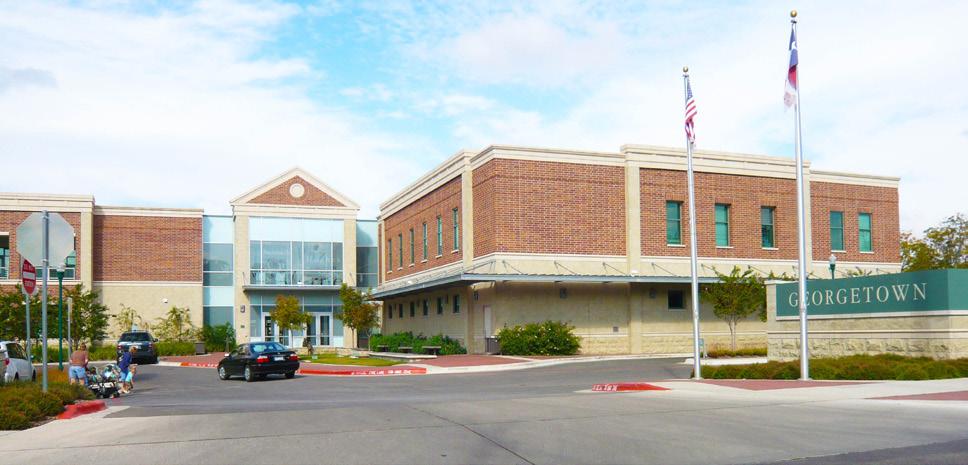
8 City of Georgetown Downtown Master Plan Update MASTER PLAN UPDATE In the past 10 years, Georgetown has been quite successful in preserving historic resources and promoting economic development downtown, particularly in the blocks framing and adjacent to the historic courthouse. A new library and arts center add to the civic and cultural purpose of downtown and new restaurants, retail and wineries have helped enliven and enrich the downtown experience. New townhomes have also presented new housing options. Pedestrian circulation and trails, a major component of the original Master Plan, have improved and each year new capital improvements are made to accommodate more pedestrian activity downtown. Even with recent success, downtown still faces some challenges that could threaten its competitive advantage. It lies in a corridor of other communities that can attract desirable businesses by offering a small town atmosphere. If Georgetown fails to maintain the character of its downtown core and enhance its vitality, then its competitive edge in a broader arena of regional economic and community development would be diminished. The city has therefore taken the initiative to update their master plan to stay competitive. The ideas presented in this document, the Downtown Master Plan Update, are for a future character, one that is not yet realized, but that can easily be achieved if City, County, and business leaders put forth a concerted effort towards implementation. All of the recommendations in this plan are designed to work together, in a cohesive urban design system. PROGRESS SINCE ORIGINAL MASTER PLAN Since the adoption of the 2003 Master Plan, the citizens and staff of Georgetown have utilized the document as intended and numerous projects have been initiated as a result of the planning effort. Even through a national economic recession, the City of Georgetown was able to make smart investments and emerge as a community with momentum focused on advancing quality of life. The numbers speak for themselves: in 2002, the city s valuation was approximately $2.4 billion and by 2013 the tax base was approximately $4.7 billion. Sales tax generation went from $3.54 million in 2002 to $8.84 million in The overall bond rating for Georgetown is scored at an AA+. The city utilized economic development tools to directly and indirectly impact many projects. Both public and private investment has occurred. Some of the notable projects are listed on the following pages. The new Central Library serves as a community icon and destination. 4
 Public Parking Lot (9th Street and Main Street) Streetscape improvements (mainly")
 PRIVATE INVESTMENT Two Rivers Residential Development - not in the study area, but influential to")
 Grape Creek and Georgetown Wineries (downtown square) El Monumento restaurant (2nd Street & Austin Ave.")
 The Hollow restaurant (downtown square) Hummingbird Hollow retail (9th Street and Austin Ave.")
 The Southern Hippie retail (8th Street & Main Street) Streetscape improvements and an upgraded public parking lot along")
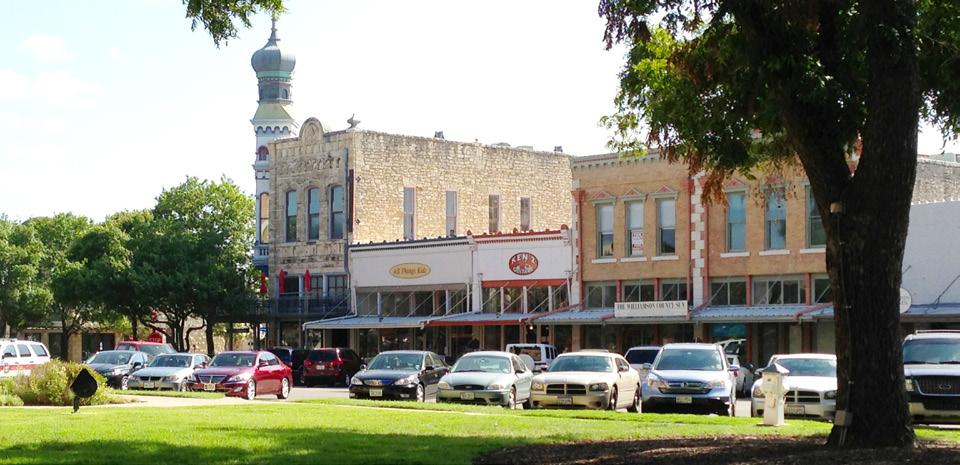
9 Introduction PUBLIC INVESTMENT Justice Center, County Jail and Public parking structure (4th Street & Rock Street) Georgetown Central Library (8th Street and Forest Street) Public Parking Lot (9th Street and Main Street) Streetscape improvements (mainly along Austin Avenue and Main Street) Signage and wayfinding improvements (throughout downtown) Downtown Art Center and Splash Pad (9th Street & Main Street) PRIVATE INVESTMENT Two Rivers Residential Development - not in the study area, but influential to downtown resurgence (Austin Avenue & San Gabriel Village Blvd.) Grape Creek and Georgetown Wineries (downtown square) El Monumento restaurant (2nd Street & Austin Ave.) Ruby K s restaurant (8th Street & Church Street) Thundercloud Subs restaurant (9th Street & Main Street) Gumbo s restaurant (downtown square) The Hollow restaurant (downtown square) Hummingbird Hollow retail (9th Street and Austin Ave.) Union on 8th event center (8th Street and Myrtle Street) All Things Kids retail (downtown square) The Escape retail (downtown square) The Southern Hippie retail (8th Street & Main Street) Streetscape improvements and an upgraded public parking lot along Main Street have helped activate Main Street and make it more walkable. New restaurants have helped enliven downtown. 5
10 Scenic Dr. Elm St. Myrtle St. Church St. Main St. Elm St. Ash St. City of Georgetown Downtown Master Plan Update LEGEND: San Gabriel Village Blvd. South San Gabriel River Martin Luther King St. El Monumento Austin Ave. E. 2nd St. New Public Project New Public Streetscape New Private Project New Private Business Downtown Overlay District Boundary Proposed Extension of District Boundary Forest St. E. 3rd St. West St. Parking Structure E. 4th St. W. 4th St. Townhomes Justice Center Jail E. 5th St. W. 5th St. Tamiro Plaza E. 6th St. W. 6th St. Monument Cafe E. 7th St. New Central Library Courthouse Renovation E. 8th St. W. 8th St. W. 9th St. Art Center E. 9th St. Public Parking Lot W. 10th St. E. 10th St. W. 11th St. New Retail Center E. 11th St. W. University Ave. E. University Ave. Railroad Ave. Hart St. Forest St. Austin Ave. Main St. Church St. Myrtle St. 6 MAP 2 PROGRESS SINCE 2003 Georgetown Master Plan Update Georgetown, TX January 2,

11 DOCUMENT ORGANIZATION The plan is organized in eight topic areas: Introduction 1. EXISTING CONDITIONS Reviews guiding city policies Notes opportunities and issues 2. BASIC FRAMEWORK Explains and illustrates the comprehensive vision for downtown 3. DEVELOPMENT STRATEGY Introduces the character areas Introduces new development prototypes Introduces development scenarios for key opportunity areas 4. PEDESTRIAN AND BIKE CIRCULA- TION AND STREETSCAPE DESIGN Recommends priorities for pedestrian improvements Recommends sidewalk and crosswalk enhancements Provides hierarchy of design elements 5. AUTOMOBILE CIRCULATION AND PARKING Recommends circulation improvements Provides parking strategy 6. WAYFINDING AND PUBLIC SIGNS Identifies locations for wayfinding and public signs Provides recommendations for sign design improvements Recommends design solutions for accenting important gateways 7. PARKS AND OPEN SPACE Identifies sites for new parks, plazas and open space in downtown Public art placement 8. IMPLEMENTATION STRATEGIES Identifies funding mechanisms Identifies criteria for setting priorities 7
12 City of Georgetown Downtown Master Plan Update ILLUSTRATIONS NOTE: The Downtown Master Plan Update incorporates several illustrations that demonstrate design concepts. These include sketches of some specific development opportunities. Note that the sketches illustrate how the principles would be applied to these situations, but they do not dictate that the sites are to be developed as shown. PLAN BOUNDARY NOTE: This plan establishes policies for the Downtown Overlay District only, as shown in the Plan Boundary (Map #1.) In some cases, maps within the document include diagrams that extend beyond this area, for the purposes of illustrating functional relationships with adjoining neighborhoods. This does not mean that policy ideas from the Downtown Overlay District should extend beyond the boundaries and into those areas. 8
7-PARKS, OPEN SPACE & PUBLIC ART
 7-s, Open Space & Public Art 7-PARKS, OPEN SPACE & PUBLIC ART This chapter provides recommendations for the expansion of new parks, plazas and open space that serve the many user groups targeted for downtown.
2-FRAMEWORK STRATEGY
 2-Framework Strategy 2-FRAMEWORK STRATEGY The Downtown Master Plan Update is based on a framework of organizational concepts that should guide investment in the area. All of the components of the plan
5-AUTOMOBILE CIRCULATION & PARKING
 5-Automobile Circulation & Parking 5-AUTOMOBILE CIRCULATION & PARKING Parking and automobile circulation are always popular topics for downtowns. Citizen concerns in Georgetown have to do with high traffic
6-GATEWAYS, WAYFINDING & PUBLIC SIGNS
 6-GATEWAYS, Wayfinding & ublic Signs 6-GATEWAYS, WAYFINDING & UBLIC SIGNS Downtown Georgetown has a strong base of local users as well as seasonal tourists and visitors. Many first-time visitors, and those
AUTO CIRCULATION & PARKING
 CHAPTER 5 Chapter 5 Auto Circulation & Parking AUTO CIRCULATION & PARKING Parking use and automobile circulation have been topics of many discussions on street corners as well as at public workshops and
City Center Master Plan
 City Center Master Plan Bellingham, Washington August 2002 City Center Master Plan Bellingham, Washington August 2002 Prepared for the City of Bellingham by: Winter & Company Hoshide Williams Architects
TEMPLE MEDICAL & EDUCATION DISTRICT
 City of Temple, Texas TEMPLE MEDICAL & EDUCATION DISTRICT 1 Description. The City of Temple joined in partnership with key public and private entities to jointly promote education and medical activities
Pedestrian and Bike Bridge LOGO
 6.2.2 Pedestrian and Bike Bridge The proposed pedestrian and bike crossing re-envisions the existing bridge at Pismo Creek on Cypress Street. The bridge is currently underutilized by vehicular through
Chapter 2 Basic Framework
 CHAPTER 2 BASIC FRAMEWORK Chapter 2 Basic Framework The Downtown Master Plan is based on a framework of organizational concepts that should guide development in the area. All of the components of the plan
10 Implementation. Implementation. Responsibility for Implementation. Blueprint for Bloomsburg. Town of Bloomsburg Comprehensive Plan 10-1
 Implementation 10 Implementation This chapter overviews how to use the comprehensive plan as a land use and programming tool for the Town of Bloomsburg and recommends annual review of the plan by the Town
Sheridan Boulevard S TAT I O N A R E A P L A N S H E R I D A N B O U L E VA R D S TAT I O N A R E A P L A N
 Sheridan Boulevard S TAT I O N A R E A P L A N 1 City of Lakewood Adopted November, 2006 S H E R I D A N B O U L E VA R D S TAT I O N A R E A P L A N The Vision The City of Lakewood s overall vision is
Wadsworth Boulevard S TAT I O N A R E A P L A N
 Wadsworth Boulevard S TAT I O N A R E A P L A N City of Lakewood Adopted November, 2006 The Vision The City of Lakewood s overall vision is to transform the area around the light rail station into a mixed-use
9/19/2018 TODAY S WEBINAR AGENDA CONTINUING EDUCATION UPCOMING TRAINING FROM APBP
 TODAY S WEBINAR AGENDA 3:00 pm: Introduction 3:05 pm: Presentation 3:45 pm: Questions 4:00 pm: Webinar Ends For technical assistance during the webinar: 1-800-263-6317 Choose these prompts: 1, 1, 1 CONTINUING
Table of Contents. Elm Avenue Improvement Plan City of Waco, Texas. Introduction 1. Existing Context 1 Figure 1 2.
 Table of Contents Introduction 1 Existing Context 1 Figure 1 2 Plan Guidelines 3 Future Urban Form 4 The West-End 4 Main Street 6 The East-End 7 Figure 2 9 Public Improvement Recommendations 7 General
DRAFT PLAN PRESENTATION
 DRAFT PLAN PRESENTATION 1.23.2018 AGENDA Process Project Schedule Results from Visioning Workshop Draft Plan Highlights Concept Plans Feedback Next Steps PROJECT SCHEDULE KICK-OFF WORKSHOP August 29 th
The transportation system in a community is an
 7 TRANSPORTATION The transportation system in a community is an important factor contributing to the quality of life of the residents. Without a sound transportation system to bring both goods and patrons
hermitage town center
 hermitage town center A Community Vision prepared by Strada for The City of Hermitage and The Mercer County Regional Planning Commission January 2007 table of contents introduction 3 design principles
City of Nogales General Plan
 Open Space, Parks, Recreation and Trails City of Nogales General Plan Residents of Nogales place a high priority in the development of a comprehensive system of open space, parks, recreation and trails
Public input has been an important part of the plan development process.
 Lakewood s Comprehensive Plan recognizes that transportation helps shape the community, and that the way the community provides for the safe and efficient movement of people affects the character of the
Dyersville Downtown Plan. Open House October 24, 2017
 Dyersville Downtown Plan Open House October 24, 2017 What is a Comprehensive Plan? - Vision - Guidance for decisions - Basis for regulations What is a Downtown Plan? - Understand priorities - Identify
Route 1 Corridor Study
 Route 1 Corridor Study Westbrook, Connecticut A Vision for the Connecticut Shoreline Public Informational Meeting July 28, 2015 Lower Connecticut River Valley Council of Governments Fitzgerald & Halliday,
Small Area Plan. South Gateway
 Small Area Plan Adopted May 12, 2008 South Gateway Purpose. The South Gateway Small Area Plan defines the City s expectations for the future of the southern entrance to the City at Interstate 85 and Highway
Policies and Code Intent Sections Related to Town Center
 Policies and Code Intent Sections Related to Town Center The Town Center Vision is scattered throughout the Comprehensive Plan, development code and the 1994 Town Center Plan. What follows are sections
CHAPTER 7: Transportation, Mobility and Circulation
 AGLE AREA COMMUNITY Plan CHAPTER 7 CHAPTER 7: Transportation, Mobility and Circulation Transportation, Mobility and Circulation The purpose of the Transportation, Mobility and Circulation Chapter is to
Citizen Advisory Group Meeting 5: Land Use April 14, 2011
 Citizen Advisory Group Meeting 5: Land Use April 14, 2011 Meeting Agenda 1. Background Review 2. Transportation Follow-up 3. PED Overlay Approach 4. Land Use Mapping 5. Group Exercise 6. Wrap-up and Next
About Momentum Midland
 About Momentum Midland Achieving a community s full potential in terms of economic development and quality of life is critically important to its long term sustainability. Core to achieving this is a vibrant
ANC 2A Presentation. November 9, 2006
 ANC 2A Presentation November 9, 2006 Introduction & Overview Applicants Boston Properties and KSI Services (project developers) The George Washington University (land owner) 2.66 acre site (former GW hospital
University of Denver Land Use Plan Update I. Executive Summary
 Executive Summary The task of developing a Land Use Plan for the University of Denver has been an exciting collaborative process that engaged a variety of interested people, including members of the University
City of Brookfield 2035 Comprehensive Plan. DRAFT #2 October 6, 2009
 City of Brookfield 2035 Comprehensive Plan DRAFT #2 October 6, 2009 Public Hearing Presentation: December 1, 2009 Process Overview Phase I: Community Visioning (2008) - Developed long-term vision to direct
A Vibrant Downtown. Chapter 5 Cary Public Art Opportunities 31
 A Vibrant Downtown Cary s vision for Downtown is a unique, vibrant, dynamic, pedestrian friendly location; a regional destination and a place to live, work, and recreate, according to the 2001 Town Center
CHAPTER 1. Ms. Guajardo s Class - Central Elementary CH 1 1
 INTRODUCTION CHAPTER 1 Ms. Guajardo s Class - Central Elementary CH 1 1 1.1 SETTING South Centre City is a linear corridor south of Downtown Escondido paralleling Centre City Parkway and South Escondido
Sherri Ferguson. President/CEO Portland Chamber of Commerce. Tennessee Certified Economic Developer Capstone Project
 Sherri Ferguson President/CEO Portland Chamber of Commerce Tennessee Certified Economic Developer Capstone Project Strategic Plan Development for the North Gateway of Portland, Tennessee The New Gateway
Town Center (part of the Comprehensive Plan)
") Town Center (part of the Comprehensive Plan) Mercer Island Town Center Looking North (2014) In 1994, a year-long process culminated in a set of design guidelines and code requirements for the Town Center
Town Center (part of the Comprehensive Plan) Mercer Island Town Center Looking North (2014) In 1994, a year-long process culminated in a set of design guidelines and code requirements for the Town Center
WELCOME and introduction
 1 WELCOME and introduction Mobility Hub Locations within Burlington STUDY OVERVIEW STUDY OBJECTIVES The City of Burlington is developing four Area Specific Plans, one for each of Burlington s Mobility
City Center Specific Plan Amendments And Background Report City of Richmond. PLANNING COMMISION FINAL DRAFT January, 2001
 City Center Specific Plan Amendments And Background Report City of Richmond PLANNING COMMISION FINAL DRAFT January, 2001 TABLE OF CONTENTS Page LIST OF TABLES... LIST OF FIGURES... INDEX... OVERVIEW...
8implementation. strategies
 PROGRAM STRATEGIES 8implementation strategies T he implementation actions of this chapter are designed to support and carry out the land use, economic development, transportation, urban design, and program
City of Long Beach. creating vibrant and exciting places
 City of Long Beach creating vibrant and exciting places Land Use Element Urban Design Element Overview of the two draft General Plan elements Discuss areas of change Economic goals of the plans Case study
JANUARY 19, 2011 CENTRAL AVENUE-METRO BLUE LINE TRANSIT-ORIENTED DEVELOPMENT IMPLEMENTATION PROJECT COMMUNITY FORUM
 CENTRAL AVENUE-METRO BLUE LINE TRANSIT-ORIENTED DEVELOPMENT IMPLEMENTATION PROJECT COMMUNITY FORUM JANUARY 19, 2011 THE MARYLAND-NATIONAL CAPITAL PARK AND PLANNING COMMISSION PRINCE GEORGE S COUNTY PLANNING
1 October Dear Citizens of Charlotte and Mecklenburg County,
 1 October 2011 Dear Citizens of Charlotte and Mecklenburg County, As co-chairs of the Center City 2020 Vision Plan Steering Committee, we are proud to present the Center City 2020 Vision Plan, which sets
SUBJECT: Waterfront Hotel Planning Study Update TO: Planning and Development Committee FROM: Department of City Building. Recommendation: Purpose:
 Page 1 of Report PB-23-18 SUBJECT: Waterfront Hotel Planning Study Update TO: Planning and Development Committee FROM: Department of City Building Report Number: PB-23-18 Wards Affected: 2 File Numbers:
EXISTING COMPREHENSIVE PLAN
 EXISTING COMPREHENSIVE PLAN Town Center Land Use Element: V. LAND USE POLICIES Town Center Mercer Island's business district vision as described in "Your Mercer Island Citizen-Designed Downtown" was an
3. VISION AND GOALS. Vision Statement. Goals, Objectives and Policies
 Vision Statement Queen Creek s interconnected network of parks, trails, open spaces and recreation opportunities provide safe and diverse activities and programs that sustain its unique, small town, equestrian
4.1.3 LAND USE CATEGORIES
 4.1.3 LAND USE CATEGORIES a. City Center District The City Center District incorporates the existing character and mix of uses in downtown Belmont to encourage redevelopment and new development in keeping
Introduction. Chapter 1. Purpose of the Comprehensive Plan Plan Organization Planning Process & Community Input 1-1
 Chapter 1 Introduction Lakewood 2025: Moving Forward Together Purpose of the Comprehensive Plan Plan Organization Planning Process & Community Input 1-1 Purpose of the Comprehensive Plan The Comprehensive
City of Heath. Town Center Concept
 In the give-and-take of getting projects designed, financed, and approved, the famous refrain from the film Field of Dreams is heard often: if you build it, they will come. From the perspective of the
WAC #7 3/14/14. Coachella General Plan Update
 WAC #7 3/14/14 Coachella General Plan Update Agenda 2 Introductions Public Draft General Plan Overview and Discussion of Next Steps Implementation and Evaluation Health Element Process Evaluation (discussion)
Hockessin Community Redevelopment Plan
 Hockessin Community Redevelopment Plan 3.1 Introduction The Community Redevelopment Plan for the Village of Hockessin is the result of the people s vision for a distinct village center that serves as the
The Auburn Plan Designing the Future of Auburn February 28, 2005
 The Auburn Plan Designing the Future of Auburn February 28, 2005 Block-by-Block Bicycle Tour Aerial survey Focus Group Meetings September 7 and 8 Design Workshops October 11, 14, and 21 Revitalization
PRINCE GEORGE S PLAZA TRANSIT DISTRICT DEVELOPMENT PLAN AND TRANSIT DISTRICT OVERLAY ZONE UPDATE
 PRINCE GEORGE S PLAZA TRANSIT DISTRICT DEVELOPMENT PLAN AND TRANSIT DISTRICT OVERLAY ZONE UPDATE UNIVERSITY PARK TOWN LISTENING SESSION JUNE 12, 2014 Prince George s County Planning Department The Maryland-National
7Page 91 CLEMMONS COMMUNITY COMPASS 7 COMMUNITY CHARACTER
 7 Community Character The beauty of Clemmons won t necessarily be a reflection of our past, but our future. This quote from Comprehensive Plan Steering Committee member Wayne Dodson captures the essence
City of Farmington. Downtown Plan. Amendment to the 1998 Master Plan Adopted October 11, 2004
 City of Farmington Amendment to the 1998 Master Plan Adopted October 11, 2004 Introduction Planning Background 1 Scope and Components of the Plan Amendment 2 Concept Introduction 3 Plan Concepts 3 Conceptual
Introducing the Main Street Strategic Toolbox
 Ulster County Main Streets: A Regional Approach Ulster County Planning Department, 244 Fair Street, Kingston NY 12401 Why do we take a regional approach to Main Streets? There are many different approaches
EXHIBIT A. Tax Increment Reinvestment Zone No. 1 (Town Center) First Amended Project Plan 1
 First Amended Project Plan 1") EXHIBIT A Tax Increment Reinvestment Zone No. 1 (Town Center) First Amended Project Plan 1 1 As amended by Resolution No. 2008-02-001(TR1R) of the Tax Increment Reinvestment Zone No.1, and approved to
EXHIBIT A Tax Increment Reinvestment Zone No. 1 (Town Center) First Amended Project Plan 1 1 As amended by Resolution No. 2008-02-001(TR1R) of the Tax Increment Reinvestment Zone No.1, and approved to
Downtown Subarea Plan
 Downtown Subarea Plan Downtown Subarea Plan Downtown is the historic heart of the. Charles community. Its traditional Main reet, the Fox River, and civic uses give it a unique prominence and character.
The University District envisions, in its neighborhood
 Envisioning the University District Link Light Rail in Seattle s neighborhoods CIY OF SEALE CONCEP-LEVEL SAION AREA PLANNING RECOMMENDAION RESOLUION # 30165 EXHIBI L Vision 08.2000 he University District
38 Queen s University Campus Master Plan Part 1
 38 Queen s University Campus Master Plan Part 1 46 The Campus at the City Scale Chapter 4 The Campus at the City Scale 39 Queen s is an urban University centrally located in Kingston. Decisions made by
1.0 Purpose of a Secondary Plan for the Masonville Transit Village
 Report to Planning and Environment Committee To: Chair and Members Planning & Environment Committee From: John M. Fleming Managing Director, Planning and City Planner Subject: Masonville Transit Village
Project Profile BAR HARBOR
 1 BAR HARBOR The Bar Harbor Master Plan merges community vision with design guidelines to preserve the unique character of Bar Harbor Village. PROJECT SUMMARY Overview: The economic vitality of Bar Harbor
Corridors. Re-vitalize our Corridors and Gateways
 Corridors Re-vitalize our Corridors and Gateways Artist s rendering from the 287 Strategic Plan, 2015 Corridors are the major throughways of Loveland but they also provide important commercial, community
Good Design Guidelines for Downtown. Preliminary Findings and Recommendations
 Good Design Guidelines for Downtown Preliminary Findings and Recommendations City Council Meeting - February 5, 2017 Advisory Committee Team: Larry Paul: Planning Commission /Architect Bruce Bagnoli: Business
Project Goal. RRRC Living Towns Planning Workshp. Town of Halifax Revitalization Project. Dynamic Planning & Management Duo: July 12, 2006
 Project Goal Town of Halifax Revitalization Project RRRC Living Towns Planning Workshp July 12, 2006 Town of Halifax Halifax County *** Revitalization Project Goal*** To create Economic Opportunity and
Corridor Vision. 1Pursue Minnehaha-Hiawatha Community Works Project. Mission of Hennepin County Community Works Program
 1Pursue Minnehaha-Hiawatha Community Works Project Minnehaha-Hiawatha Community Works is a project within the Hennepin Community Works (HCW) program. The mission of the HCW program is to enhance how the
LAND USE ELEMENT. Purpose. General Goals & Policies
 LAND USE ELEMENT Purpose This Land Use Element contains the goals and policies necessary to support the City s responsibility for managing land resources and guiding development through implementing regulations,
Welcome. Walk Around. Talk to Us. Write Down Your Comments
 Welcome This is an information meeting introducing the applications for proposed redevelopment of the Yorkdale Shopping Centre site at 3401 Dufferin Street and 1 Yorkdale Road over the next 20+ years,
Port Lavaca Future Land Use
 Port Lavaca Future Land Use Introduction The City of Port Lavaca is beginning to see sustained growth, after many years of relative stable population. New single family homes, apartments, and businesses
Courthouse Square Planning & Urban Design Study. Courthouse Square Working Group #13 October 15, 2014
 Courthouse Square Planning & Urban Design Study Courthouse Square Working Group #13 October 15, 2014 1 Courthouse Square Process Working Group Community Courthouse Square Advisory Groups & Civic Associations
City of Ennis. Downtown Master Plan Catalyst Projects
 City of Ennis Downtown Master Plan Catalyst Projects Revised Framework Plan REVISED Project Types and Descriptions Project Types A. Visitor Attracting Projects: Projects in this category are intended to
Broken Arrow Comprehensive Plan Update Public Workshop Meeting #3 January 23,
 Broken Arrow Comprehensive Plan Update Public Workshop Meeting #3 January 23, September 25,2018 2018 26 April 2016 AGENDA 1. Status Presentation - Charrette Recap - Proposed Vision Framework - Preliminary
Chapter 4: The Vision
 Chapter 4: The Vision This plan is organized around the community vision detailed in this chapter. The vision describes the collective thoughts, values, and hopes of the community for its future. The community
CHAPTER 6: Community Design and Appearance
 AGLE AREA COMMUNITY Plan CHAPTER 6 CHAPTER 6: Community Design and Appearance Community Design and Appearance How a community is designed and what a community looks like are attributes fundamental to the
Draft Plan Recommendations
 Draft Plan Recommendations Sponsored by Henry County and the Atlanta Regional Commission T S W TEAM Tunnell-Spangler-Walsh & Associates URS Corporation Marketek Study Area 1,300 acres Includes parts of
Technical Appendix L, University Community Plan Town Center
 Technical Appendix L, University Community Plan Town Center Table of Contents L.1 Executive Summary L.2 Merced County University Community Plan, 2004 Findings L.2.1 Visioning L.2.2 UCP Goals, Objectives
Chapter 4. Linking Land Use with Transportation. Chapter 4
 Chapter 4 Linking Land Use with Transportation Chapter 4 59 Chapter 4 Linking Land Use with Transportation Community Design and Transportation Program Introduction Since the 1950s, the predominant development
Cumberland Region Tomorrow is a private, non-profit, citizen based regional organization working with Greater Nashville Regional Council
 Cumberland Region Tomorrow is a private, non-profit, citizen based regional organization working with Greater Nashville Regional Council and others in the public and private sectors, dedicated to planning
Land Use. Hardware Street Vendor Mixed-Use
 Land Use Definition Land Use is the way a piece of real estate is utilized. Existing, proposed, and adopted land uses all play a role in the planning process. Once a land use plan is adopted, the next
City of Fort Lauderdale UPTOWN URBAN VILLAGE. Public Workshop December 7, 2016
 Public Workshop December 7, 2016 Workshop Agenda Introductions Project Presentation o o o History Project Scope/Timeline Character of Study Area o o o o Land Use Public Realm/Pedestrian Mobility Multimodal
Plan Overview. Manhattan Area 2035 Reflections and Progress. Chapter 1: Introduction. Background
 Plan Overview The Manhattan Urban Area Comprehensive Plan (the Comprehensive Plan) is a joint planning initiative of the City of Manhattan, Pottawatomie County, and Riley County. The 2014 Comprehensive
Town of Peru Comprehensive Plan Executive Summary
 Town of Peru Comprehensive Plan Executive Communities that plan grow by choice, not by chance. A plan makes growth thoughtful, understandable, and predictable. A plan shows that a community is managing
3 Vision and Goals. Vision and Goals. Blueprint for Bloomsburg. Vision. Town of Bloomsburg Comprehensive Plan,
 Vision and Goals 3 Vision and Goals Citizens of the Town of Bloomsburg clearly value their natural and cultural heritage, the walkable, mixed use pattern of downtown, the access to education, and the community
The Five Components of the McLoughlin Area Plan
 The Five Components of the McLoughlin Area Plan This documents contains the complete language of the five components of the McLoughlin Area Plan: The Vision Statement The Values The Guiding Principles
DRAFT ROOSEVELT ROAD. District Recommendations. Figure 5.23 The Roosevelt Road Corridor
 CHAPTER 5 Figure 5.23 The Road Corridor Road will develop as a mixed-use corridor, emphasizing regional retail, west of the river and mixed-use development east of the river. KEY RECOMMENDATIONS 1. High
Town Center. Block 5 Existing multifamily residential units are expected to remain.
 Area Guidelines Germantown s districts should be developed as distinct communities with unique features that are supported through the guidelines. The guidelines not only help distinguish these districts
3. Endorse the LRT vision in transforming Surrey into Connected-Complete-Livable communities, and more specifically, the official vision statement:
 CORPORATE REPORT NO: R038 COUNCIL DATE: February 20, 2017 REGULAR COUNCIL TO: Mayor & Council DATE: February 16, 2017 FROM: General Manager, Engineering FILE: 8740-01 SUBJECT: Surrey Light Rail Transit
public review draft Key objectives for this chapter are:
 5 - parks & open space Providing a rich collection of outdoor places for informal gathering and recreation, as well as planned promotional activities and community events, is a key concept for Midtown.
Somers Point Master Plan
 Somers Point Master Plan Progress Report and Public Meeting August 20, 2014 Master Plan Reexamination Municipal Land Use Law require that all municipalities reexamine their master plan every ten years.
VILLAGE & TOWN OF BERGEN: COMPREHENSIVE PLAN
 VILLAGE & TOWN OF BERGEN: COMPREHENSIVE PLAN CPC Public Hearing April 21, 2016 History 1996 Comprehensive Plan Comprehensive Plan Update Committee Consultant (LaBella Associates): December 2014 Residents
EXECUTIVE SUMMARY DRAFT CHAPTER 1 INTRODUCTION EXECUTIVE SUMMARY
 CHAPTER 1 EXECUTIVE SUMMARY INTRODUCTION Through the joint efforts of the City of Tulsa planning staff and the Land Services division of Indian Nations Council of Governments (INCOG), the Berryhill Land
Town of Cobourg Heritage Master Plan. Statutory Public Meeting
 Town of Cobourg Heritage Master Plan Statutory Public Meeting April 25 th 2016 Presentation Overview 1. Introduction 2. Project background and schedule overview 3. Review of strategic direction content
BROOKLYN PARK / 85TH AVE LRT STATION CDI DEVELOPMENT GUIDELINES DRAFT
 August 2018 Page intentionally left blank The Brooklyn Park Library adjacent to the 85th Ave LRT Station Area. OVERVIEW The Blue Line LRT Extension / Bottineau corridor offers a unique opportunity to leverage
ROBBINSDALE LRT STATION CDI DEVELOPMENT GUIDELINES
 August 2018 OVERVIEW The City of Robbinsdale has a prime-opportunity site in the middle of the 13 mile stretch of the Bottineau LRT corridor / Blue Line extension. Robbinsdale offers a prominent, vital,
North Salt Lake General Plan Update 2013
 North Salt Lake General Plan Update 2013 Acknowledgements Updating the North Salt Lake General Plan was a process that would not have been possible without the support of elected officials and the general
University of the District of Columbia Van Ness Campus Master Plan Community Open House 3. December 8, 2010
 University of the District of Columbia Van Ness Campus Master Plan Open House 3 December 8, 2010 Introductions Sequence of Work: Campus Master Plan BEGIN: INTRODUCE AND START WORK Project Initiation Team
PIKE PINE RENAISSANCE: ACT ONE. October 19, 2017
 PIKE PINE RENAISSANCE: ACT ONE October 19, 2017 WATERFRONT SEATTLE PROGRAM PROJECT INTRODUCTION Pike and Pine streets, between First and Melrose avenues Pedestrian and streetscape improvements Budget:
 Community Workshop #2 December 4, 2014 Team Tonight s Agenda 6:00 pm Welcome! 6:05 pm The Future of Downtown Tustin Ideas, Strategies and Recommendations 6:35 pm Questions and Comments 6:50 pm Open
ARLINGTON COUNTY PLANNING COMMISSION SITE PLAN REVIEW COMMITTEE SITE PLAN CHAIR GUIDE
 ARLINGTON COUNTY PLANNING COMMISSION SITE PLAN REVIEW COMMITTEE SITE PLAN CHAIR GUIDE Excerpts from the SPRC Operating Guide, 1/31/04 Revised March 17,2010 1. Site Plan Chair Responsibilities 1 1, The
Ivywild On The Creek PRELIMINARY CREEK DISTRICT MASTER PLAN
 Ivywild On The Creek PRELIMINARY CREEK DISTRICT MASTER PLAN Introduction: Rejuvenating an extraordinary Creekside neighborhood THE CREEKSIDE DISTRICT The Ivywild On The Creek Neighborhood District Master
Downtown Papillion. Concepts for the Enhancement and Growth of Papillion s Traditional Town Center
 Downtown Papillion Concepts for the Enhancement and Growth of Papillion s Traditional Town Center Developed for the City of Papillion by RDG Planning & Design T raditional downtown districts occupy a particular
SECTION ONE: INTRODUCTION. introduction
 introduction 1 INTRODUCTION Since it was first established in 1843 as a trading post for the Hudson s Bay Company, Victoria has evolved into a Provincial capital city that is recognized across Canada and
DENVER DESIGN DISTRICT GDP
 DENVER DESIGN DISTRICT GDP Urban Design Standards and Guidelines November 17, 2008 Amended February 3, 2016 City and County of Denver CF Property Management, Inc. C/O Denver Design District - Starboard
Arlington, Virginia is a worldclass
 EXECUTIVE S U M M A RY Arlington maintains a rich variety of stable neighborhoods, quality schools and enlightened land use policies, and received the Environmental Protection Agency s highest award for