Quick Introduction to Biodiversity Planning in South Africa
|
|
|
- Gwen Malone
- 6 years ago
- Views:
Transcription


1 Quick Introduction to Biodiversity Planning in South Africa BGIS training UWC December 2013 Fahiema Daniels and Jeffrey Manuel Biodiversity Planning and Mainstreaming Acknowledgements: Charl de Villiers, Tammy Smith, Amanda Driver, Mandy Cadman, Caroiine Petersen, Genevieve Pence, Neville v/d Westhuizen, Fahiema Daniels and Tsamaelo Malebu
2 What is Biodiversity? And how do we give spatial expression to it?
")
 Purifying water and")


3 Biodiversity Pattern = what you can see (structure and composition) Ecological Process = what you can t see (function) Purifying water and releasing it slowly Recycling of nutrients Trapping carbon and moisture Pollinating trees kms away Evolving and adapting to changing climate Processes need space and corridors some are tied to the physical environment, some are flexible in space


4 The ecosystem approach Biomes Vegetation types Habitats Ecosystems are surrogates for all components of biodiversity (including species)

5 Key question: How do we locate and manage biodiversity conservation and other land uses appropriately? We need to identify spatial biodiversity priorities

6 How do we set spatial biodiversity priorities? Through the systematic biodiversity planning process, enabled by the Bioregional Plan provision in the Biodiversity Act


7 Systematic biodiversity planning WHAT? Biodiversity pattern Ecological processes HOW MUCH? WHERE?

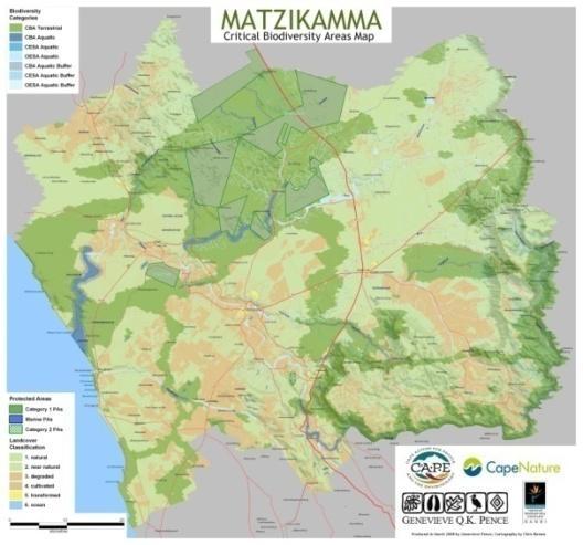
8 Summary of Map categories Critical Biodiversity Areas All the areas required to meet biodiversity pattern and ecological process targets. Must be maintained in a natural or nearnatural state. Included in ecological corridors to maintain connectivity. Ecological Support Areas support the ecological functioning of critical biodiversity areas Must be maintained in at least a functional state Other Natural Areas Not required to meet biodiversity pattern or process targets provided CBAs are not lost. i.e. suitable for sustainable development.
9 What is a Bioregional Plan? Spatial Plan Based on a Systematic Biodiversity Plan. Shows terrestrial and aquatic features in a landscape critical to conserving biodiversity and ecosystem services. Include land-use guidelines. Can include guidelines for effective management of biodiversity features and ecosystem services.
10 Review Implement Develop Steps to be undertaken by the organisation leading the development and implementation of the bioregional plan, usually the provincial conservation authority** Undertake systematic biodiversity plan, unless one exists already at an appropriate scale. Engage with key stakeholders already at this early stage if possible. Steps to be undertaken by the MEC, Minister or SANBI In addition to these steps, SANBI is available to provide technical support at all stages of the process At least months Alert MEC or Minister of intention to develop a bioregional plan Prepare draft bioregional plan* -Based on systematic biodiversity plan -According to content requirements in Chapter 6 of Guideline - Engage with key stakeholders, especially municipalities, to resolve conflicts (if they exist) between the draft bioregional plan and relevant IDPs, SDFs, EIPs, EMPs etc Submit the draft plan to SANBI for review. If necessary, make required changes in consultation with relevant stakeholders and resubmit the plan to SANBI. Submit the draft plan to the MEC (if it falls within a province) or Minister (if it straddles 2 provinces) The Minister or MEC responds within 30 days. If no response is received, assume it s OK to proceed. SANBI convenes Bioregional Plan Review Panel, which provides a report on the technical merits of the plan At least 2 members of the Bioregional Plan Review Panel confirm that the required changes have been made and makes recommendation to the Minister or MEC. Minister or MEC undertakes consultation and public participation as required in the Act. Minister or MEC amends the plan as appropriate, preferably with input from the provincial conservation authority and/or SANBI Minister or MEC declares bioregion and publishes bioregional plan months At least 3 months, assuming no changes required Time requirement untested. Likely to be several months Implement the plan -Lead or co-ordinate implementation of relevant aspects of the plan -Monitor implementation of the plan by intended users, using indicators specified in the plan SANBI maintains register of published plans and makes them available to the public via BGIS Maximum 5 years Co-ordinate review and updating of the plan, and submit progress report and amended plan to the MEC or Minister * This could be a Biodiversity Sector Plan (if intention is not to publish the plan in terms of the Biodiversity Act) ** The lead organisation may be, for example, a municipality or an NGO. If so, these steps must be undertaken in close collaboration with the provincial conservation authority
11 Contents of a bioregional plan A: Introduction & objectives B: Biodiversity profile C: Map D: Landuse Guidelines E: Other measures for effective management F: Monitoring, reviewing & updating G: GIS files
 Transformation Data (how")

")

 Planning Units (units of")


12 Biodiversity Data (what to conserve) Transformation Data (how much is left) Biodiversity Targets (how much needs to be kept natural or conserved) Protected Areas (how much is formally conserved) Software & GIS (tools used to identify the best places to meet targets) Marxan & CLUZ (computer software) Planning Units (units of analysis) Abundance Information (how much each unit can contribute to targets) Outputs: Portfolio (most efficient set of units required to meet targets) Design & Prioritization


13 Systematic biodiversity planning process Map of critical biodiversity areas plus profile and land-use guidelines Biodiversity sector plan plus process of publishing in terms of Biodiversity Act Bioregional plan
14 Publishing a Bioregional Plan Minister or MEC may declare bioregions and publish a bioregional plan Bioregion boundaries must align with administrative boundaries Bioregions must be configured as local municipalities, metros, district municipalities, or groups of municipalities A municipality or province can request the Minister to publish bioregional plan A published bioregional plan must be reviewed every 5 years
15 Status of a Bioregional Plan Purpose: Guide LUP and decision-making. Must be taken into account in IDP, SDP, EIP, EMP processes any decision-making subject to NEMA principles any form of integrated environmental management. Requires alignment and coordination between BPs and prior planning frameworks Municipal IDPs must be aligned with a BP. Does not grant/remove rights.
16 Biodiversity Planning Products

17 Key indicatoress Ecosystem type Ecosystem condition Location of protected areas Evaluate proportion in good condition against series of thresholds Compare proportion protected with biodiversity target Ecosystem threat status Ecosystem protection level


18 Ecosystem Threat Status Terrestrial Critically endangered Endangered Vulnerable Least threatened Rivers Wetlands Estuaries Coastal & inshore Offshore CR EN VU LT 0% 20% 40% 60% 80% 100% % of ecosystem types


19 Ecosystem Protection Level Not protected Poorly protected Moderately protected Well protected Not protected Poorly protected Moderately protected Well protected
20 Listing of Threatened Ecosystems Biodiversity Act provides for listing threatened or protected ecosystems: Critically Endangered Endangered Vulnerable Protected To date only threatened terrestrial ecosystems have been listed Listed Ecosystems have and explicit link to EIA regs


21 Draft list of threatened terrestrial ecosystems: summary statistics CR EN VU Total TEs Number Remaining natural area ha ha ha % of SA 0.7% 2.0% 6.8% 9.5% ha
22 Langkloof Shale Renosterveld Cape Vernal Pools Kouebokkeveld Alluvium Fynbos Bushmanland Vloere Citrusdal Vygieveld Eastern Lower Karoo Grootrivier Quartzite Fynbos Kamiesberg Mountains Shrubland Knersvlakte Dolomite Vygieveld Namaqualand Blomveld Namaqualand Salt Pans Namaqualand Seashore Vegetation Robertson Granite Renosterveld Vanrhynsdorp Gannabosveld Piketberg Quartz Succulent Shrubland Swartland Alluvium Renosterveld Western R ens Shale Renosterveld Mossel Bay Shale Renosterveld Breede Quartzite Fynbos Eastern Upper Karoo Eastern Little Karoo Breede Alluvium Renosterveld R ens Silcrete Renosterveld Uniondale Shale Renosterveld Southern Karoo Riviere Garden Route Granite Fynbos Swartland Granite Renosterveld Swartland Shale Renosterveld Willowmore Gwarrieveld Cape Flats Sand Fynbos Robertson Karoo Namaqualand Klipkoppe Shrubland Breede Sand Fynbos Swartland Alluvium Fynbos Atlantis Sand Fynbos Montagu Shale Renosterveld Roggeveld Shale Renosterveld Hopefield Sand Fynbos Cape Coastal Lagoons Swartruggens Quartzite Fynbos Swellendam Silcrete Fynbos Gamka Karoo Namaqualand Riviere Potberg Ferricrete Fynbos Prince Albert Succulent Karoo Southern Coastal Forest Agulhas Sand Fynbos Agulhas Limestone Fynbos Western Gwarrieveld Swartberg Shale Renosterveld Swartberg Shale Fynbos Cape Flats Dune Strandveld North Langeberg Sandstone Fynbos South Kammanassie Sandstone Fynbos Gamka Thicket Boland Granite Fynbos Upper Karoo Hardeveld Swartruggens Quartzite Karoo Saldanha Flats Strandveld Northern Knersvlakte Vygieveld Hangklip Sand Fynbos North Sonderend Sandstone Fynbos South Langeberg Sandstone Fynbos Kouga Sandstone Fynbos Central Coastal Shale Band Vegetation Lourensford Alluvium Fynbos Tanqua Wash Riviere Knersvlakte Quartz Vygieveld Overberg Dune Strandveld Matjiesfontein Shale Fynbos North Hex Sandstone Fynbos North Rooiberg Sandstone Fynbos South Outeniqua Sandstone Fynbos Peninsula Granite Fynbos Eastern Coastal Shale Band Vegetation Cape Lowland Freshwater Wetlands Cape Estuarine Salt Marshes South Swartberg Sandstone Fynbos Kogelberg Sandstone Fynbos Tsitsikamma Sandstone Fynbos Central Inland Shale Band Vegetation North Swartberg Sandstone Fynbos Peninsula Sandstone Fynbos Biodiversity Targets, Ecosystem Threat Status and Protection level 100% 90% 80% 70% 60% 50% Conservation Threshold (CR) Conservation Threshold (EN) Conservation Threshold (VU) Conservation Threshold (LT) % of total extent formally conserved 40% 30% 20% 10% 0%
23 What s the relationship between threatened ecosystems and CBAs? All CR ecosystems = CBAs (by definition remaining natural parts of these ecosystems are required to meet biodiversity representation thresholds) Some EN ecosystems = CBAs Some VU ecosystems = CBAs Some LT ecosystems = CBAs Parts of these ecosystems are required to meet biodiversity representation and persistence thresholds. Most appropriate areas are identified based on design principles: Efficiency Conflict avoidance Climate change design principles


24 Freshwater ecosystem priority areas

25 What s the relationship between FEPAs and CBAs? FEPAs are identified at a scale coarser than 1: FEPAs focus on freshwater ecosystems only, whereas CBA maps focus on freshwater and terrestrial in an integrated way FEPAs feed into the development of CBAs maps, but do not supercede CBAs.
The Jigsaw: Legal Instruments for Biodiversity Planning in South Africa
 The Jigsaw: Legal Instruments for Biodiversity Planning in South Africa Annual Conference, Environmental Law Association AUGUST 2012 Dr. Marie Parramon-Gurney Head of Programmes: Sustainability and Development
ENVIRONMENTAL IMPACT ASSESSMENT
 ENVIRONMENTAL IMPACT ASSESSMENT NOTICE OF ENVIRONMENTAL IMPACT ASSESSMENT PROCESS FOR THE SARATOGA VEGETATION CLEARING SECTION 24G ON PORTION 4 OF THE FARM KLAAS VOOGDS RIVIER NO. 40, ROBERTSON, WESTERN
Fabriek Street 45 Paarl. P.O. Box 2632 Paarl Tel: Cell:
 11 July 2016 Organisation: Department of Environmental Affairs and Development Planning Attention: Mr. Shafeeq Mallick NOTICE OF FIRST PUBLIC PARTICIPATION PERIOD: 12 July 2016 15 August 2016 GNEC Code:
Cape Environmental Assessment Practitioners(Pty)
") BACKGROUND INFORMATION DOCUMENT (BID) Introduction Cape Environmental Assessment Practitioners(Pty) Ltd Reg. No. 2008/004627/07 Telephone: (044) 874 0365 First Floor, Eagles View Building Facsimile: (044)
BACKGROUND INFORMATION DOCUMENT (BID) Introduction Cape Environmental Assessment Practitioners(Pty) Ltd Reg. No. 2008/004627/07 Telephone: (044) 874 0365 First Floor, Eagles View Building Facsimile: (044)
!"#"$%&'"()*%+*,*-.%/"0.%(,$*&$,(*+%/*)1"* 2"314314("*!.2)/.5)* 0/%-$"/2!,$*+./"*2),).%(*-%,/!/%%'6*78*',/51*9:7;*
*%+*,*-.%/0.%(,$*&$,(*+%/*)1* 2314314(*!.2)/.5)* 0/%-$/2!,$*+./*2),).%(*-%,/!/%%'6*78*',/51*9:7;*") !"#"$%&'"()*%+*,*-.%/"0.%(,$*&$,(*+%/*)1"* 2"314314("*!.2)/.5)* 0/%-$"/2!,$*+./"*2),).%(*-%,/!/%%'6*78*',/51*9:7;* Meeting Agenda Item Discussion Item Presenter 1. Opening and Welcome 2. Introductions
!"#"$%&'"()*%+*,*-.%/"0.%(,$*&$,(*+%/*)1"* 2"314314("*!.2)/.5)* 0/%-$"/2!,$*+./"*2),).%(*-%,/!/%%'6*78*',/51*9:7;* Meeting Agenda Item Discussion Item Presenter 1. Opening and Welcome 2. Introductions
Bioregional Plan for the Ekurhuleni Metropolitan Municipality
 Bioregional Plan for the Ekurhuleni Metropolitan Municipality Compiled by Ekurhuleni Metropolitan Municipality November 2011, revised March 2014 Executive Summary This Bioregional Plan covers the Ekurhuleni
Assessing the integration of biodiversity priorities in local land-use planning using international and local case studies.
 Assessing the integration of biodiversity priorities in local land-use planning using international and local case studies. Khumbelo Makhuvha (UKZN & MTPA) 09/06/2016 Overview Introduction Types of integration
DRAFT CASE STUDY. Connectivity Conservation Law through the Eyes of the Greater Cederberg Biodiversity Corridor. prepared by
 DRAFT CASE STUDY Connectivity Conservation Law through the Eyes of the Greater Cederberg Biodiversity Corridor prepared by Dr Alexander Ross Paterson Associate Professor Institute of Marine and Environmental
Attention: Interested and Affected Party (I&AP) Commenting Period: 22 November January 2018 GNEC Code: 20327
 Commenting Period: 22 November January 2018 GNEC Code: 20327") 22 November 2017 Attention: Interested and Affected Party (I&AP) Commenting Period: 22 November 2017 15 January 2018 GNEC Code: 20327 Dear Interested and Affected Party INFORMING START OF 30 DAY PUBLIC
22 November 2017 Attention: Interested and Affected Party (I&AP) Commenting Period: 22 November 2017 15 January 2018 GNEC Code: 20327 Dear Interested and Affected Party INFORMING START OF 30 DAY PUBLIC
HARTENBOS NORTH (population: Census 2011)
") 5.8 HARTENBOS NORTH (population: + 184 Census 2011) Figure 5.8.1.1 Hartenbos North: Aerial photograph CNdV africa (Pty) Ltd DRAFT CONCEPTUAL DEVELOPMENT FRAMEWORK REPORT page 439 5.8.1 SPATIAL ANALYSIS,
5.8 HARTENBOS NORTH (population: + 184 Census 2011) Figure 5.8.1.1 Hartenbos North: Aerial photograph CNdV africa (Pty) Ltd DRAFT CONCEPTUAL DEVELOPMENT FRAMEWORK REPORT page 439 5.8.1 SPATIAL ANALYSIS,
4. What are the goals of the Kawarthas, Naturally Connected project? 7. What are watersheds and why are they being used as the project boundaries?
 Frequently Asked Questions (FAQs) 1. What are Natural Heritage Systems (NHS)? 2. Why are they important? 3. Which areas of the province have undertaken NHS projects? 4. What are the goals of the Kawarthas,
14.5 HOPEFIELD: (REFER PLAN 39 AND PLAN 40)
") URBAN DYNAMICS WESTERN CAPE INC. 248 14.5 HOPEFIELD: (REFER PLAN 39 AND PLAN 40) FIGURE 83: LOCALITY - HOPEFIELD Within the context of the Saldanha Bay Municipal area, Hopefield, an historical agricultural
URBAN DYNAMICS WESTERN CAPE INC. 248 14.5 HOPEFIELD: (REFER PLAN 39 AND PLAN 40) FIGURE 83: LOCALITY - HOPEFIELD Within the context of the Saldanha Bay Municipal area, Hopefield, an historical agricultural
Protected Areas: Context for Planning and Management Parks Canada Perspective
 Protected Areas: Context for Planning and Management Parks Canada Perspective Mark Yeates 1 and Paul Zorn 1 A/Manager, Ecosystem Conservation Parks Canada, Ontario Service Centre 111 Water Street East
Landscape Conservation Design April, 2014
 Designing Sustainable Landscapes in the Northeast A project of the North Atlantic Landscape Conservation Cooperative & Northeast Climate Science Center Landscape Conservation Design April, 2014 Conceptual
GREEN NETWORK APPLICATIONS IN ESTONIA
 GREEN NETWORK APPLICATIONS IN ESTONIA Kalev Sepp, Tuuli Veersalu, Martk Külvik Estonian University of Life Sciences 1 WHY? BACKGROUND - POLITICAL By adopting the Pan-European Biological and Landscape Diversity
THE GREENBELT ACT AND PLAN
 Ontarians have come to value the Greenbelt since it was created in February 2005. It protects 1.8 million acres of environmentally sensitive and agricultural land around the Greater Golden Horseshoe. Growing
Local Government Climate Change Support Program Northern Cape Inception Workshop
 Local Government Climate Change Support Program 2016 Northern Cape Inception Workshop Workshop Aims 1. Introduce the LGCCS and different tools as part of the LGCCS 2. Introduce the process of conducting
BACKGROUND INFORMATION DOCUMENT
 BACKGROUND INFORMATION DOCUMENT PROPOSED UPGRADING OF THE N2 NATIONAL ROAD FROM KRAAIBOSCH TO DIE VLEIE BASIC ENVIRONMENTAL IMPACT ASSESSMENT The South African National Roads Agency Society Limited (SANRAL)
MOPANI DISTRICT BIOREGIONAL PLAN
 MOPANI DISTRICT BIOREGIONAL PLAN APPENDIX 2: PROCESS AND CONSULTATION REPORT Complied by: Limpopo Department of Economic Development, Environment and Tourism (LEDET) October 2016 Preface This is the first
REDZ & POWER CORRIDOR GAZETTING. 25 July Environmental Advisory Services
 REDZ & POWER CORRIDOR GAZETTING 25 July 2017 Environmental Advisory Services PURPOSE To provide general progress on the REDZs and Power corridor gazetting process To provide a range of comments received
ENVIRONMENTAL IMPACT ASSESSMENT
 ENVIRONMENTAL IMPACT ASSESSMENT NOTICE OF ENVIRONMENTAL IMPACT ASSESSMENT PROCESS FOR THE PROPOSED HAASENDAL DEVELOPMENT AND KUILS RIVER GOLF COURSE RE-DEVELOPMENT ON ERF 23580, ERF 23579, ERF 23582, ERF
INTEGRATING PROTECTED AREAS INTO THE WIDER LANDSCAPE, SEASCAPE AND RELATED SECTORS. An Overview
 INTEGRATING PROTECTED AREAS INTO THE WIDER LANDSCAPE, SEASCAPE AND RELATED SECTORS An Overview USING AN EXAMPLE FROM NORTHEAST US Relationship of IPAWLS guide to other planning and assessment processes
CHAPTER 4: CONTEXTUALISING THE PROPOSED PROJECT ENVIRONMENT WITHIN THE NATIONAL AND LOCAL
 : CONTEXTUALISING THE PROPOSED PROJECT WITHIN THE NATIONAL AND LOCAL ENVIRONMENT CONTENTS 4. CONTEXTUALISING THE PROPOSED PROJECT WITHIN THE NATIONAL AND LOCAL ENVIRONMENT 4-1 4.1 Introduction to the Coega
BACKGROUND INFORMATION DOCUMENT (BID) AND INVITATION TO PARTICIPATE
 AND INVITATION TO PARTICIPATE") To: Interested and Affected Parties 2 October 2017 NOTIFICATION OF ENVIRONMENTAL IMPACT ASSESSMENT PROCESS FOR THE PROPOSED DEVELOPMENT OF RESIDENTIAL HOUSING ON PORTION 56 OF THE FARM CHELSEA NO. 25,
To: Interested and Affected Parties 2 October 2017 NOTIFICATION OF ENVIRONMENTAL IMPACT ASSESSMENT PROCESS FOR THE PROPOSED DEVELOPMENT OF RESIDENTIAL HOUSING ON PORTION 56 OF THE FARM CHELSEA NO. 25,
Blue/Green Infrastructure Study Accomack County, VA
 Blue/Green Infrastructure Study Accomack County, VA Draft Asset Maps March 8-9, 2010 Green Infrastructure Center, Inc. 2 Overview What is Green and Blue Infrastructure Project Timeline & Tasks Literature
SANBI Biodiversity Series 4 (2006) people making biodiversity work
 people making biodiversity work") people making biodiversity work Table Mountain Fund C.A.P. E. Signatory Partners SANBI Biodiversity Series 4 Fynbos Fynmense: people making biodiversity work Ally Ashwell Trevor Sandwith Mandy Barnett
people making biodiversity work Table Mountain Fund C.A.P. E. Signatory Partners SANBI Biodiversity Series 4 Fynbos Fynmense: people making biodiversity work Ally Ashwell Trevor Sandwith Mandy Barnett
THE CORPORATION OF THE CITY OF WINDSOR Office of the City Solicitor Planning Department
 THE CORPORATION OF THE CITY OF WINDSOR Office of the City Solicitor Planning Department REPORT TO THE CITY OF WINDSOR PLANNING ADVISORY COMMITTEE DATE OF REPORT: August 19, 2010 SUBJECT: Official Plan
Key Elements of Successful Conservation Planning. John Paskus October 17, 2013 Pierce Cedar Creek Institute Michigan Natural Features Inventory
 Key Elements of Successful Conservation Planning John Paskus October 17, 2013 Pierce Cedar Creek Institute Michigan Natural Features Inventory What is Conservation Planning? Pressey et al (2008): The process
Land Use Regional Planning in Alberta Collaborating with Stakeholders
 Land Use Regional Planning in Alberta Collaborating with Stakeholders Trevor Lema, Land & Integrated Management Planner September 2018 Overview Why Regional Planning? An Integrated Perspective Integrated
Collaborative Conservation across Landscapes: Experiences from the Upper Midwest and Great Lakes LCC 2/29/2016. GreatLakesLCC.org
 Collaborative Conservation across Landscapes: Experiences from the Upper Midwest and Great Lakes LCC 2/29/2016 GreatLakesLCC.org Personal introduction Brad Potter - Science Coordinator for the Upper Midwest
Good practices in management planning for Natura 2000 sites
 Good practices in management planning for Natura 2000 sites Luboš Halada Institute of Landscape Ecology SAS Branch Nitra, Akademická 2, 949 10 Nitra, Slovakia lubos.halada@savba.sk Habitats Directive requirements
Incorporating climate change and connectivity into the Mpumalanga Biodiversity Sector Plan
 Incorporating climate change and connectivity into the Mpumalanga Biodiversity Sector Plan Mervyn Lotter Scientific Services Mpumalanga Tourism & Parks Agency Date: 15 May 2014 Introduction 1. Actively
Monitoring for Ecological Integrity and State of the Parks Reporting
 Monitoring for Ecological Integrity and State of the Parks Reporting Donald McLennan 1 and Paul Zorn 1 National Monitoring Biologist Parks Canada, Ecological Integrity Branch 25 Eddy Street Gatineau, Québec,
Assessing Five Years of CEPF Investment in the Cape Floristic Region Biodiversity Hotspot. A Special Report April 2007
 Assessing Five Years of CEPF Investment in the Cape Floristic Region Biodiversity Hotspot A Special Report April 2007 CONTENTS Overview... 3 CEPF 5-Year Logical Framework Reporting... 19 Appendices...
VCA Guidance Note. Contents
 Contents 1. Introduction... 2 2. Who can register a VCA?... 2 3. VCAs and sustainable development... 3 4. Verifying conservation performance... 4 4.1 Transparent, voluntary commitments... 4 4.2 Independent
Cape Environmental Assessment Practitioners (Pty) Ltd
 Ltd") Cape Environmental Assessment Practitioners (Pty) Ltd Reg. No. 2008/004627/07 Telephone: (044) 874 0365 Facsimile: (044) 874 0432 17 Progress Street, George Web: www.cape-eaprac.co.za PO Box 2070, George
Cape Environmental Assessment Practitioners (Pty) Ltd Reg. No. 2008/004627/07 Telephone: (044) 874 0365 Facsimile: (044) 874 0432 17 Progress Street, George Web: www.cape-eaprac.co.za PO Box 2070, George
STEWARDSHIP OF LONG ISLAND SOUND S ECOLOGICAL AND RECREATIONAL RESOURCES
 STEWARDSHIP OF LONG ISLAND SOUND S ECOLOGICAL AND RECREATIONAL RESOURCES Robin Kriesberg, Save the Sound, Inc. Thomas Halavik, US Fish and Wildlife Service Coastal Program An Initiative to Identify, Protect
MERIDAN PLAINS SAND RESOURCE AREA
 MERIDAN PLAINS SAND RESOURCE AREA INFORMATION SHEET October 2010 BACKGROUND The Meridan Plains Extractive Resource Area is located on the western fringe of the coastal urban communities of Caloundra West
TERMS OF REFERENCE MALASPINA COMPLEX COASTAL PLAN
 TERMS OF REFERENCE MALASPINA COMPLEX COASTAL PLAN A. RATIONALE Land and Water BC, resource user groups and the Powell River Regional District have requested that the Ministry of Sustainable Resource Management
PROPOSED GARDEN CITY NEW TOWN DEVELOPMENT, KRAAIFONTEIN DRAFT ENVIRONMENTAL IMPACT REPORT Summary Document
 1 PROPOSED GARDEN CITY NEW TOWN DEVELOPMENT, KRAAIFONTEIN DRAFT ENVIRONMENTAL IMPACT REPORT Summary Document What is an Environmental Impact Assessment? Garden Cities Incorporated Association Not For Gain
Peninsular Florida Landscape Conservation Cooperative. Marine and Estuarine Priority Resources and Conservation Targets
 Peninsular Florida Landscape Conservation Cooperative Marine and Estuarine Priority Resources and Conservation Targets Why are we here today? Workshop Goals: Develop a list of potential conservation targets
Aquatic, Terrestrial and Landscape Conservation Design Tools and Products of the North Atlantic LCC
 Aquatic, Terrestrial and Landscape Conservation Design Tools and Products of the North Atlantic LCC Scott Schwenk Science Coordinator, North Atlantic LCC Chesapeake Bay FWS Partners Meeting Annapolis,
Green Infrastructure Case Study Template
 Green Infrastructure Case Study Template The aim of the exercise is to provide information on how the elements of the Green Infrastructure Strategy are implemented at national level and to provide case
3-2 Environmental Systems
 3-2 Environmental Systems 3.0 ENVIRONMENTAL SYSTEMS CONTENTS 3.1 GREENWAY SYSTEM 3.1.1 General Policies 3.1.2 Natural Heritage Network 3.1.3 Natural Heritage Network Enhancement Lands 3.1.4 Rouge Watershed
Next steps Vision and Mission Science Priorities Objective Conservation Framework Actions
 Vision: A conservation community, that while governed by their unique purposes and missions, collaborates on sustaining lands and waters that support natural and cultural resources and the services they
50-year Water & Wetland Vision for England WORKSHOP DETAILS
 50-year Water & Wetland Vision for England Workshop 3: Wetland vision maps; your feedback on draft maps, methodology and ways forward 7 th December 2006 WORKSHOP DETAILS Theme 1: Methodology and prioritisation
Landscape Ecology and EA in Ontario:
 Landscape Ecology and EA in Ontario: Bridging Gaps in Biodiversity Assessment Christina Rehbein, Dr. Scott Mitchell & Dr. Mike Brklacich Carleton University OAIA 2017 18 October 2017 Biodiversity and EA
Indigenous biodiversity, restoration and the perfect New Zealand City. Bruce Clarkson, Cilla Wehi & Lars Brabyn
 Indigenous biodiversity, restoration and the perfect New Zealand City Bruce Clarkson, Cilla Wehi & Lars Brabyn Important note to users This power point is as presented at the New Zealand Ecological Society
Lower Columbia River and Coastal Landscape Conservation Design
 Today s Presenters: Lower Columbia River and Coastal Landscape Conservation Design John Mankowski, North Pacific Landscape Conservation Cooperative Sara Evans-Peters, Pacific Birds Tom Miewald, US Fish
LIVING INFRASTRUCTURE PLAN
 LIVING INFRASTRUCTURE PLAN AUSTRALASIAN NETWORK FOR ECOLOGY AND TRANSPORTATION 30 APRIL 2018 Maggie Baron, Melbourne Metro Rail Authority Sheridan Blunt, Loci Environment & Place Inc. RAIL AND SUSTAINABILITY
Making Data Work for You: Free Mapping Tools for Prioritization and Property Research
 Making Data Work for You: Free Mapping Tools for Prioritization and Property Research Ariel Maiorano amaiorano@massaudubon.org Abby Hardy-Moss abby@ecga.org Essex County Open Space Conference March 25,
Our Constitutional imperative
 PARLIAMENT: PUBLIC HEARINGS EFFICACY OF SOUTH AFRICA'S ENVIRONMENTAL IMPACT ASSESSMENT (EIA) REGIME Henri Fortuin Cape Town 29July 2013 Our Constitutional imperative Section 24 of our Constitution gives
Options for addressing City of Edmonds Alternatives to Ecology s Required Changes addressing Edmonds Marsh Buffers and Setbacks.
 Options for addressing City of Edmonds Alternatives to Ecology s Required Changes addressing Edmonds Marsh Buffers and Setbacks. This document presents Ecology s response to the City of Edmonds alternatives
CONTENTS. 3. Background. 4. Proceedings. 6. Discussion Points. 8. Concluding Comments. 8. Way Forward. 9. Appendix One: programme
 This document summarises the outcomes of a travelling Workshop focused on ecological restoration within the Arid zone hosted by Conservation South Africa and Nurture Restore Innovate from 5-11 September
Brockton. Produced in This report and associated map provide information about important sites for biodiversity conservation in your area.
 CONSERVING THE BIODIVERSITY OF MASSACHUSETTS IN A CHANGING WORLD Brockton Produced in 2012 This report and associated map provide information about important sites for biodiversity conservation in your
Project Summary. Rationale
 Modeling and Evaluating Potential Constraints Between Siting of Commercial Wind Power and Ecological and Social Values in the Mountains of the Northern Forest Principal Investigator(s): Dr. David Publicover
Staff will be providing an overview of the project need, purpose and intent for consideration as part of the Amendment cycle.
 Agenda Item D-2 City of Tacoma Planning and Development Services To: Planning Commission From: Stephen Atkinson, Planning Services Division Subject: Open Space Corridors Project Meeting Date: March 1,
St. Lawrence Neighbourhood Focused Area - Official Plan Amendment Status Report
 STAFF REPORT ACTION REQUIRED St. Lawrence Neighbourhood Focused Area - Official Plan Amendment Status Report Date: May 21, 2015 To: From: Wards: Reference Number: Toronto and East York Community Council
Pathway to 2020 Protected Areas Workshop for New Brunswick
 Pathway to 2020 Protected Areas Workshop for New Brunswick Setting the Stage for New Brunswick Roberta Clowater Executive Director, Canadian Parks and Wilderness Society NB Chapter 1 Convention on Biological
CITY COUNCIL AGENDA REPORT
 CITY COUNCIL AGENDA REPORT Subject: COUNCIL MOTION LRT ALIGNMENT REMOVAL FROM THE TRANSPORTATION MASTER PLAN On February 10, 2016 Councillor Hughes provided notice in accordance with Section 23 of Procedure
CITY OF VAUGHAN EXTRACT FROM COUNCIL MEETING MINUTES OF NOVEMBER 15, 2016
 Item 11, Report No. 38, of the Committee of the Whole, which was adopted without amendment by the Council of the City of Vaughan on November 15, 2016. Regional Councillor Di Biase declared an interest
EXHIBIT A CITY OF FORT WALTON BEACH, FLORIDA COASTAL MANAGEMENT & CONSERVATION
 EXHIBIT A CITY OF FORT WALTON BEACH, FLORIDA INTRODUCTION The Coastal Management and the Conservation Elements required by Chapter 9J-5.012 and 5.013, F.A.C., respectively, have been combined into one
PDS June 1, 2016 Page 1. Planning and Development Committee. MEETING DATE: Wednesday, June 01, 2016
 Page 1 REPORT TO: Planning and Development Committee MEETING DATE: Wednesday, June 01, 2016 SUBJECT: ROPA 12: Project Initiation Report Regional Official Plan Amendment (ROPA # 12) Watercourse Policies
Botanical Impact Assessment, Erf 34 and 14435, Wellington, Drakenstein Municipality Western Cape Province
 Botanical Impact Assessment, Erf 34 and 14435, Wellington, Drakenstein Municipality Western Cape Province Gregory Nicolson in association with Dr David J. McDonald Bergwind Botanical Surveys & Tours CC.
Ashton WMF WP
 09/26/2017 31 Allen Drive Loevenstein Cape Town 7530 South Africa C00720-AWMF-VIA-001 www.advisian.com Disclaimer This report has been prepared on behalf of and for the exclusive use of Legacy Environmental
for Biosphere Reserves
 Sustainable Tourism in Biosphere Reserves in Central and Eastern Europe Tourism Management Plans for Biosphere Reserves Ecological Tourism in Europe - E.T.E. e.v. Page 1 What is a Tourism Management Plan?
Expert Workshop on Integrating Protected Areas into wider Land and seascapes- Costa Rican case
 Expert Workshop on Integrating Protected Areas into wider Land and seascapes- Costa Rican case International Academy of Nature Conservation The island of Vilm, Germany 2-4 Nov 2008 1. Getting started SINAC-MINAE
Planning for Staten. Habitat Restoration and Green Infrastructure. Island s North Shore
 Habitat Restoration and Green Infrastructure Planning for Staten Island s North Shore Community Board 1 March 1, 2018 NYC Parks Forestry, Horticulture, and Natural Resources Funded by the NYS Department
GEOMETRIC IMPROVEMENTS AND WATERMAIN LOOPING MUNICIPAL CLASS ENVIRONMENTAL ASSESSMENT
 GEOMETRIC IMPROVEMENTS AND WATERMAIN LOOPING MUNICIPAL CLASS ENVIRONMENTAL ASSESSMENT Veterans Way (previously Powerline Road) and Klondike Park Road Wasaga Beach Welcome Please sign in Take a comment
An Introduction to the Far North Land Use Strategy
 An Introduction to the Far North Land Use Strategy December, 2013 Ministry of Natural Resources Table of Contents PREFACE... 3 About the Far North... 3 Evolution of Land Use Planning in the Far North...
systems is available on the Colorado Wetland Information Center (CWIC) website.
 website.") Colorado Natural Heritage Program Wetland Program Plan -- Dec 2015 Status Update and Addendum -- The Colorado Natural Heritage Program (CNHP) developed a Wetland Program Plan (WPP) in 2010 for the planning
Colorado Natural Heritage Program Wetland Program Plan -- Dec 2015 Status Update and Addendum -- The Colorado Natural Heritage Program (CNHP) developed a Wetland Program Plan (WPP) in 2010 for the planning
Case Study: Kavango- Zambezi Transfrontier Conservation Area
 Case Study: Kavango- Zambezi Transfrontier Conservation Area Presented by: Keith Lawrence, CI Report Author: Prof. David Cumming Project Contact: Leo Braack, CI Presentation Outline Background: KAZA TFCA
Fingal Development Plan & Green Infrastructure. Nicholas O Kane Senior Executive Planner Fingal County Council
 Fingal Development Plan 2011-2017 & Green Infrastructure Nicholas O Kane Senior Executive Planner Fingal County Council 2011 Fingal Development Plan Must be in compliance with National Spatial Strategy
Stock-Taking on Integrated Coastal Zone Management (ICZM) in the Black Sea IMPLEMENTATION AUDIT QUESTIONNAIRE 2010
 in the Black Sea IMPLEMENTATION AUDIT QUESTIONNAIRE 2010") Stock-Taking on Integrated Coastal Zone Management (ICZM) in the Black Sea IMPLEMENTATION AUDIT QUESTIONNAIRE 2010 PURPOSE The purposes of this questionnaire are: (a) to perform the policy, legal and institutional
Stock-Taking on Integrated Coastal Zone Management (ICZM) in the Black Sea IMPLEMENTATION AUDIT QUESTIONNAIRE 2010 PURPOSE The purposes of this questionnaire are: (a) to perform the policy, legal and institutional
BASIC ASSESSMENT PROCESS
 BASIC ASSESSMENT PROCESS NOTICE OF A BASIC ASSESSMENT PROCESS FOR THE PROPOSED MIXED USE DEVELOPMENT ON THE REMAINDER OF PORTION 2, REMAINDER OF PORTION 7, PORTION 7, REMAINDER OF PORTION 9, REMAINDER
CITY OF VAUGHAN EXTRACT FROM COUNCIL MEETING MINUTES OF DECEMBER 10, 2013
 Item 1, Report No. 55, of the Committee of the Whole (Working Session), which was adopted without amendment by the Council of the City of Vaughan on December 10, 2013. Regional Councillor Di Biase declared
Great Lakes Conservation Blueprint for Terrestrial Biodiversity on the Canadian Shield
 Great Lakes Conservation Blueprint for Terrestrial Biodiversity on the Canadian Shield Bonnie L. Henson 1, Kara E. Brodribb 2 and John L. Riley 3 1 Ontario Ministry of Natural Resources 2,3 The Nature
NORTHERN LANDS NORTHERN LEADERSHIP
 NORTHERN LANDS NORTHERN LEADERSHIP The GNWT Land Use and Sustainability Framework Our Lands, Our Interests, Our Future ii Land is Life MESSAGE FROM THE PREMIER Land is life. It is the link to our past.
Botanical Assessment for proposed Industrial Development, Apollo Bricks, Durbanville, City of Cape Town, Western Cape
 Botanical Assessment for proposed Industrial Development, Apollo Bricks, Durbanville, City of Cape Town, Western Cape Paul Emms in association with Dr David J. McDonald Bergwind Botanical Surveys & Tours
OUR GREATER SYDNEY A metropolis of three cities. OVERVIEW. connecting people. DRAFT Greater Sydney Region Plan
 OUR GREATER SYDNEY 2056. A metropolis of three cities. OVERVIEW. connecting people. DRAFT Greater Sydney Region Plan October 2017 This document is an overview of the draft Greater Sydney Region Plan. To
1 Introduction. Chapter. In this chapter:
 Chapter 1 Introduction In this chapter: 1.1 A Snapshot of the Region 1.2 Towards a Sustainable Region 1.3 The Provincial Context 1.4 Purpose and Organization The Regional Municipality of York Official
KOGELBERG BIOSPHERE RESERVE FRAMEWORK PLAN
 KOGELBERG BIOSPHERE RESERVE FRAMEWORK PLAN KOGELBERG BIOSPHERE RESERVE FRAMEWORK PLAN KOGELBERG BIOSPHERE RESERVE COMPANY TABLE OF CONTENTS CHAPTER 1: INTRODUCTION... 1 1.1 Role of Biosphere Reserves...
APPENDIX I Presentations
 APPENDIX I Presentations Workshop Summary Report 11 Peel Region Official Plan Review May 5, 2010 Compatible Active Recreation Workshop July 29, 2010 Components of PROPR Sustainability Planning Tools/Updates
Visual Impact Assessment Final Draft Report ver. 1.3 November 2015
 The Hillside Development Farm 1638 and Remainder Portion 82 of the farm Ruygte Vally 205, Knysna Sedgefield Visual Impact Assessment Final Draft Report ver. 1.3 November 2015 Prepared for: Liberty Lane
COASTAL CONSERVANCY. Staff Recommendation March 25, 2004 LOS ANGELES GREEN VISION PLAN. File No.: Project Manager: Marc Beyeler
 COASTAL CONSERVANCY Staff Recommendation March 25, 2004 File No.: 04-014 Project Manager: Marc Beyeler RECOMMENDED ACTION: Authorization to disburse up to $50,000 to the University of Southern California
Introducing Green Infrastructure for Coastal Resilience
 Introducing Green Infrastructure for Coastal Resilience National Oceanic and Atmospheric Administration (NOAA) Office for Coastal Management Gloucester, MA Office of Travel Courtesy, Tim Grafft What Is
Goleta Community Plan Update
 Goleta Community Plan Update Ecology, Biology, and Habitats GVPAC Meeting Agenda [Wednesday, December 17, 2008, 6:00PM] Pledge of Allegiance and Roll Call Public Comment Period Administrative December
Cape Environmental Assessment Practitioners (Pty) Ltd
 Ltd") Cape Environmental Assessment Practitioners (Pty) Ltd Reg. No. 2008/004627/07 Telephone: (044) 874 0365 1 st Floor Eagles View Building Facsimile: (044) 874 0432 5 Progress Street, George Web: www.cape-eaprac.co.za
Cape Environmental Assessment Practitioners (Pty) Ltd Reg. No. 2008/004627/07 Telephone: (044) 874 0365 1 st Floor Eagles View Building Facsimile: (044) 874 0432 5 Progress Street, George Web: www.cape-eaprac.co.za
Presentation to Planning Committee, DMM
 District Municipality of Muskoka Muskoka Official Plan Review Background Study: Natural Heritage Review of Urban Centres and Species At Risk Dale Leadbeater 1 September 2011 Presentation to Planning Committee,
Services Department B September 10, 2007
 Report To: Development Services Committee Item: Date of Report: DS-07-246 September 5, 2007 From: Commissioner, Development File: Date of Meeting: Services Department B7200-0001 September 10, 2007 Subject:
Venice Pumping Plant Dual Force Main Project Draft EIR
 City of Los Angeles 5.9 LAND USE PLANS 5.9.1 Environmental Setting Venice Pumping Plant Dual Force Main Project Draft EIR The Project lies within the bounds of Los Angeles County and the City of Los Angeles.
LAMPREY RIVER SUBWATERSHED
 LAMPREY RIVER SUBWATERSHED PISCATAQUA REGION ENVIRONMENTAL PLANNING ASSESSMENT 05 Lamprey River Subwatershed, including: Candia, Deerfield, Epping, Newmarket, Northwood, Nottingham, Raymond www.prepestuaries.org
PURPOSE OF MEETING MEETING GUIDELINES PROJECT BACKGROUND ESKOM CLOCOLAN-FICKSBURG 88 KV POWERLINE, FREE STATE
 ESKOM CLOCOLAN-FICKSBURG 88 KV POWERLINE, FREE STATE DRAFT BASIC ASSESSMENT REPORT PUBLIC REVIEW LANDOWNERS MEETING FICKSBURG 23 JULY 2013 T his project is being conducted on behalf of Eskom PRESENTATION
3.4 URBAN SETTLEMENTS AND HIERARCHY
 3.4 URBAN SETTLEMENTS AND HIERARCHY page 198 3.4.1 HIERARCHY AND ROLE OF THE SETTLEMENTS Mossel Bay Municipality covers an area of 2007km2, In 2007 it had the 2 nd largest population in the Eden District
PRESENTATION ON JOHANNESBURG S BIODIVERSITY PROGRAMME
 PRESENTATION ON JOHANNESBURG S BIODIVERSITY PROGRAMME Member of Mayoral Committee: Cllr Prema Naidoo Environmental Management & Johannesburg City Parks PRESENTATION OVERVIEW Jo burg Overview & Context
4 Sustainability and Growth Management
 4 Sustainability and Growth Management Introduction Traditionally, has assumed growth and development with limited consideration for the long-term negative social, environmental or economic impacts on
Biodiversity Action Plan Background Information for discussion purposes
 Biodiversity Action Plan Background Information for discussion purposes Our commitment As directed by Council, The City of Calgary has agreed to sign the Durban Commitment, an international agreement on
WITHERS ENVIRONMENTAL CONSULTANTS (Pty) Ltd.
 Ltd.") WITHERS ENVIRONMENTAL CONSULTANTS Tel: 021-887 4000 Fax: 021-883 2952 15 Mount Albert Street P.O.Box 6118 e-mail: aubrey@withersenviro.co.za STELLENBOSCH 7600 UNIEDAL 7612 ENVIRONMENTAL PLANNING IMPACT
WITHERS ENVIRONMENTAL CONSULTANTS Tel: 021-887 4000 Fax: 021-883 2952 15 Mount Albert Street P.O.Box 6118 e-mail: aubrey@withersenviro.co.za STELLENBOSCH 7600 UNIEDAL 7612 ENVIRONMENTAL PLANNING IMPACT
Bostwick Road. Municipal Class Environmental Assessment. October 13, City of London. Bostwick Road Municipal Class Environmental Assessment
 Bostwick Road Municipal Class Environmental Assessment October 13, 2016 Welcome! Welcome to the first Public Information Centre for the Bostwick Road Municipal Class Environmental Assessment. Representatives
Road Ecology in Practice: Building Resiliency of Urban Ecosystems through Informed Road Network Planning
 Road Ecology in Practice: Building Resiliency of Urban Ecosystems through Informed Road Network Planning Outline What is road ecology? Why is road ecology important? TRCA and road ecology application Peel