A Long Term Plan for the Character and Amenity of Henderson Valley/Opanuku Adopted on 21 October 2010.
|
|
|
- Terence Wilkerson
- 6 years ago
- Views:
Transcription


1 Henderson Valley/Opanuku Local Area Plan A Long Term Plan for the Character and Amenity of Henderson Valley/Opanuku Adopted on 21 October 2010.
2 Background This Henderson Valley/Opanuku Local Area Plan represents the outcome of a series of conversations, meetings and workshops with members of the local community, and promotes the purpose and objectives of the Waitakere Ranges Heritage Area Act 2008, within this Local Area. The Waitakere Ranges Heritage Area Act 2008 (the Act) provides for the preparation and adoption of Local Area Plans to: - Promote the purpose of the Act and its Objectives; - Provide long term objectives in relation to the future amenity, character and environment of the Local Area, and the wellbeing of the community that lives there; and - Inform decision making processes that relate to the heritage area. Local Area Plans must be developed using a process that encourages people to participate and contribute to the preparation of the LAP, comply with the principles of consultation in s82 of the Local Government Act 2002, has regard to the management plan for the Waitakere Ranges Regional Park, and consults with tangata whenua. The series of workshops and meetings held between March 2008 and October 2010 provided a chance for the council to listen to residents about the kind of future they want for Henderson Valley/Opanuku. The focus was on gathering and understanding people s ideas about the way the community looks, feels and functions now and in the future. Their ideas and visions for the future have been further analysed and developed to form this proposed Local Area Plan (LAP). This Plan was adopted by Waitakere City Council on 21 October Conversations with members of the community reinforced the need to set long term goals to work towards. People wanted to avoid creeping destruction of the area s character from cumulative changes. People felt a strong sense of belonging to the Valley, and an appreciation of the opportunities for living a quiet rural lifestyle in a friendly and safe community in close proximity to the amenities of metropolitan Auckland. This proximity to and contrast with nearby urban Auckland is also a source of both concern and opportunity in the desire to retain a distinctive local identity and rural character. There are four key components to the LAP: 1. the boundary which defines the area that this plan applies to; 2. the identification of features important to and valued by the community; 3. the descriptions of existing and future character and amenity; 4. the Objectives and Actions proposed to achieve the desired future character and amenity. The new Auckland Council will consider making changes to other plans to achieve the Objectives and Actions laid out in this Plan. Changes could include introducing those parts of the LAP relating to resource management into the District Plan though a Plan Change process and introducing those matters relating to council services into the Long Term Council Community Plan and Annual Plan. Community-based actions to implement the LAP will also be encouraged and enabled. The LAP development process and background reports, and summaries of community views expressed through the consultation and engagement process to date are available from or www. aucklandcouncil.govt.nz, and form part of the Background Reports to this LAP. If you have any questions please contact us on ranges@aucklandcouncil.govt.nz As a guide for decision makers this LAP will inform the new Auckland Council of the desires of this community and identify the heritage features that must be protected, restored and enhanced to achieve the identified long term future for Henderson Valley/ Opanuku. 2
3 3
4 1. Purpose of the Local Area Plan Henderson Valley/Opanuku is a special place within the Waitakere Ranges Heritage Area (Heritage Area). It exhibits key values of regional and national significance. Henderson Valley/Opanuku is adjacent to metropolitan Auckland and is therefore under significant urbanisation pressures. Henderson Valley/Opanuku contains regionally important and distinctive landscapes and character. These can be threatened by the cumulative impact of oneoff decisions by individuals and public agencies, which may result in irreversible loss of its valued character and amenity. Conversations with the community have revealed a readiness to act now to prevent such unintended loss of amenity and in the longer term to strengthen, build on and capitalise on those unique attributes that result from Henderson Valley/Opanuku s location, character and history. These attributes make up the foundation for Henderson Valley/Opanuku s environmental and landscape quality and its economic, social and community wellbeing and stability into the future. Importantly there is an understanding that the threats to this character and amenity are from both public and private actions and that having agreed on the desired future, well articulated goals and plans can guide this community towards securing that future, and contribute to avoiding loss and degradation of amenity. This Henderson Valley/Opanuku Local Area Plan (LAP) has been prepared to promote the purpose of the Waitakere Ranges Heritage Area Act 2008 (the Act) and its objectives. The LAP will inform decision-making processes related to the Henderson Valley/Opanuku Local Area by establishing long-term objectives for the area s future amenity, character and environment. The essence of the LAP is that together we can imagine, plan and influence the future. A LAP is about thinking long term, in generations rather than years. This LAP: defines the local area of Henderson Valley/Opanuku and identifies the extent and nature of the heritage features existing in the area as identified using current knowledge; identifies what should be protected and enhanced to hand on to future generations; outlines how the objectives of the Act will be promoted in Henderson Valley/Opanuku and identifies the distinctive natural, cultural, and physical qualities and characteristics of the area that contribute to its long-term amenity. As a guide, the expression long-term is taken to mean beyond a period of 50 years and the LAP seeks to establish the elements and outcomes that should be expected in that future; provides certainty to the community by establishing objectives and policies to inform decision making in relation to the amenity, character and environment of Henderson Valley/Opanuku; defines the future that is desired so that decisions can be made about whether activities and proposals contribute to or detract from the achievement of that desired future; provides a goal-orientated approach to managing adverse effects, particularly cumulative effects; and identifies issues relating to the provision of future services in Henderson Valley/Opanuku. 4
 is based on consultation with the people of Henderson Valley/Opanuku and beyond, and guidance from the Act.")
5 2. Local Area Plan Boundary The Henderson Valley/Opanuku LAP, with its description of the future character and amenity and its objectives, applies to the area identified in Figure 1. The boundary of the LAP (Figure 1 below) is based on consultation with the people of Henderson Valley/Opanuku and beyond, and guidance from the Act. The area distinguishes Henderson Valley/Opanuku from adjoining local areas within the Heritage Area, including Oratia, Waiatarua and Swanson. For more details on how the boundary has been determined, refer to the Boundary Report for Henderson Valley/ Opanuku (refer or govt.nz). It is acknowledged that residents feel a strong sense of belonging and association with Henderson Valley as a community and that the wider community of Henderson Valley may extend beyond the LAP boundary and the Waitakere Ranges and overlap with other Local Areas. The LAP seeks to support this community spirit and sense of place and is focused on addressing the future of the Henderson Valley/Opanuku Local Area, and how the desired character and amenity as expressed by the community, can be achieved. 5
6 6

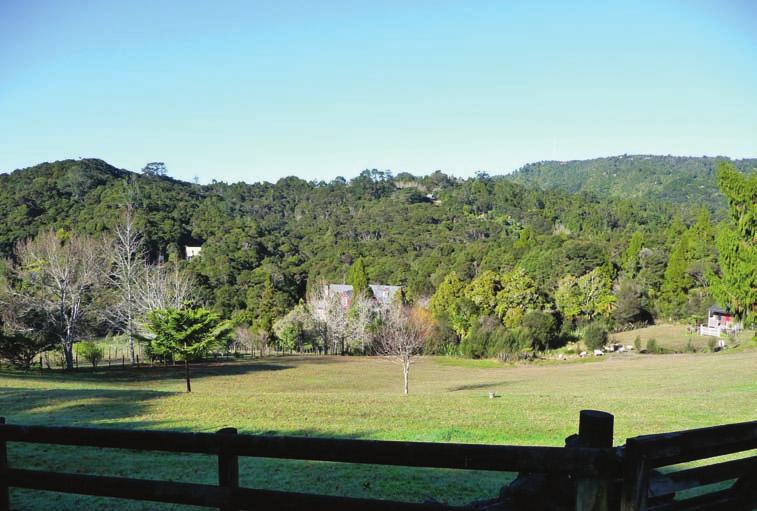
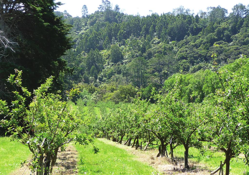
7 3. Heritage Features Section 25(3) of the Act: A LAP must (b) identify the extent and nature of the heritage features existing in the local area The Background Reports on both the Foothills and the Henderson Valley/Opanuku LAP form part of the LAP (refer or and identify the extent and nature of the Heritage Features that exist in Henderson Valley/ Opanuku and their relationship with the wider Heritage Area. This section summarises the information in the Background Reports and outlines those particular features that fall within the Henderson Valley/Opanuku Local Area and make it unique. The heritage features are valued because of the contribution they make to the local, regional and national significance of the Henderson Valley/Opanuku area and the Heritage Area as a whole. What s in a Name? The name of the LAP area - Henderson Valley/Opanuku - reflects that the LAP encompasses much of the upper catchment of the significant Opanuku waterway and its tributaries. Opanuku is also the original name given by tangata whenua to the wider area. Henderson Valley is the name that later settlers applied and is how most of the current residents refer to the area and the community that now resides there. Both histories are important and should be recognised and celebrated. Summary of the Heritage Features of Henderson Valley/Opanuku The terrestrial and aquatic ecosystems of prominent indigenous character. The terrestrial ecosystems comprise regenerating native forest that is primarily located in the upper valleys and ridges associated with the upper Opanuku Stream and its tributaries. The upper Opanuku includes forested areas that are landscapes of regional and national significance, have natural scenic beauty and include areas of the Waitakere Ranges Regional Park. In the lower valley indigenous vegetation is limited to steeper slopes, margins of streams, isolated pockets of regeneration and some areas of now rare lowland forests. These areas have intrinsic value and provide a diversity of habitats for indigenous flora and fauna. The catchment is home to a range of native species, including rare and threatened birds, reptiles, fish, amphibians and bats. The natural landforms and landscapes that contrast and connect with each other, and which collectively give the area its distinctive character. There are three main bands of landforms and landscapes in the Henderson Valley/Opanuku Valley which share common characteristics. These are characterised by the predominantly open, rural and gently undulating lower valley, the forested upper-valley transitioning into the Waitakere Ranges which slope steeply down from the main Scenic Drive ridgeline, and the residential enclaves straddling and marking the transition from lower to upper valley. The Scenic Drive ridgeline contributes to the dramatic western backdrop of metropolitan Auckland and encloses the valley. Historically developed, the almost suburban residential enclaves sit within and between the pasture and bush, wild uncultivated areas and managed rows of horticultural vegetation, and draw much of their rural amenity from these surroundings, and combined with rural style roading infrastructure provides a strong sense of being a rural lane. The rolling, flatter, more open lower valley includes contrasting and intertwined pockets of bush, pastoral, horticultural, visitor and educational activities. The landscape of the lower valley includes a predominance of exotic vegetation, pastoral, vineyard and orchard activity, shelter belts, sparsely settled areas and pockets of indigenous vegetation, particularly along the Opanuku Stream. 7

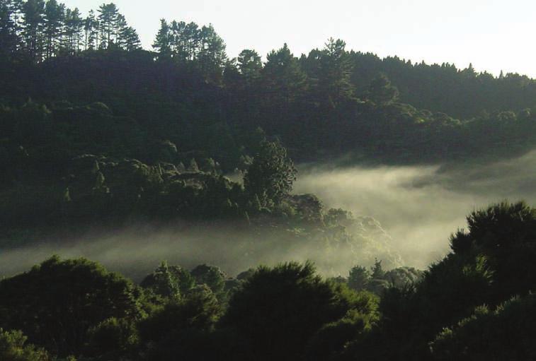
8 3. Heritage Features COnTInueD Section 25(3) of the Act: A LAP must (b) identify the extent and nature of the heritage features existing in the local area The naturally functioning Opanuku Stream and its tributaries which originate in the Waitakere Ranges. The streams have not been dammed for water supply purposes and contribute positively to downstream ecology, urban character, stormwater management, erosion control and flood protection, and water quality is very good in the upper catchment. Fairy Falls near the head of Stoney Creek is an impressive cascade of multiple waterfalls down the solid lava bedrock of the Ranges. In the lower valley the many tributaries cross the landscape and provide both habitat and visual separation, joining with the main Opanuku Stream which provides a key defining feature within the valley. The quietness and darkness of the Waitakere Ranges. Low levels of street lighting, generally low density settlement clustered on quiet lanes with limited through traffic and houses screened by vegetation or setback from the main road contribute to a relatively dark night sky and a sense of sparse settlement, particularly in the upper Valley and residential enclaves. In the lower valley, larger activities, sports fields and intersection lights and higher traffic volumes result in isolated pockets of more active areas, but with a sense of peace and quiet predominating. Wilderness experiences, recreation and relaxation are provided by a network of walking tracks, footpaths and viewing areas associated with the Waitakere Ranges Regional Park. In the lower Valley, visitor activities and facilities, education and retreat based activities provide for more social interaction, within a distinctive rural setting. The Valley has long been a place of rest, respite and inspiration and contains a limited number of non-residential activities, including farm parks, vineyards, wine sales, retreats, spiritual communities and education camps, as well as a diverse range of home-based and rural businesses. Henderson Valley/Opanuku is a rural place with its own intrinsic values. It also acts as a transition area from intensely urban areas through its rural areas into the forested Waitakere Ranges and provides a contrast between both metropolitan Auckland to the east and the forested Waitakere Ranges and west coast. The limited roading access though the Valley into the Ranges and west coast also limits through traffic and visitor numbers are generally low beyond the regional park trailheads and visitor generating activities. While many economically productive activities have declined, many properties are managed as lifestyle blocks, with pastoral grazing, horse sports and bush restoration. These key small holding activities which retain and enhance the rural character of the area and represent opportunities for rural living and rural activities in close proximity to urban amenities are highly valued by residents and visitors alike. The subservience of the built environment to the area s natural and rural landscapes. This feature is reflected in: - the distinctive amenity of the sparse residential sites that are located in the upper Valley amongst regenerating (and increasingly dominant) forest settings adjoining and nestled within the forested apron of the Waitakere Ranges. The proportion of built area to forest is very small with little potential for further development or subdivision beyond existing vacant sites; and - the rural character of the lower Valley and its intricate pattern of open and rolling farmland, orchards, vineyards, uncultivated areas, indigenous vegetation, streams and dispersed low density settlement with few urban scale activities. The proportion of buildings to open space is very small, but there is potential for change through the subdivision and development of the remaining larger rural sites; and - the distinctive amenity of the low-density residential enclaves (on Grassmere, ngapuka and lower Opanuku and Mountain Roads) that 8

9 3. Heritage Features COnTInueD Section 25(3) of the Act: A LAP must (b) identify the extent and nature of the heritage features existing in the local area overlap and merge with both the forested, steeper core of the Waitakere Ranges and the more open rolling, pastoral Valley. The proportion of built area to forest or open space is higher than the other two areas, with little potential for further intensification other than the development of existing vacant sites, with long narrow and almost suburban style sections, slow and quiet rural lanes, visible dwellings and clear evidence of residential settlement and community. The historical, traditional and cultural relationships of people, communities and tangata whenua with the area and their exercise of kaitiakitanga and stewardship. These include tangata whenua and later european historical relationships and evidence of occupation and use, and those of the existing community with the area. The area was part of the realms of the great forest of Tiriwa, accessed only by the grace and favour of Te Kawerau a Maki, who were also famous gardeners. Cultivation and settlement occurred within the Valley and there is evidence of kainga and storage pits on what is now the Welsh Hills area, then called Pukearuhe, which can be translated as hill (puke) of the root of the bracken fern (aruhe), which grows well on recently cleared and burned over land. Historic use of the stream, the forest, and its resources and occupation of the area including gardens and food storage has otherwise left little known permanent physical evidence other than midden and some earth workings, but historical, traditional and cultural relationships with the area are strong and enduring. Evidence of past human activities, including those in relation to occupation and use, timber extraction, gum digging, flax milling, intensive farming and orcharding. The Valley is rich in archaeological and heritage sites and is a cultural landscape of some significance. It has a number of historic structures and botanical sites, as well as evidence of a range of past activities. The Valley was milled for timber using trip dams, dug over for gum and farmed intensively and extensively. Much evidence of these activities still remains including orchards and vineyards, pastoral activities, glasshouses, poultry farms, dwellings and farm buildings, and in changes to the characteristics of the waterways and the forest remnants surrounding them. The distinctive community. Henderson Valley/Opanuku is a distinctive place, with its own unique identity and strong sense of community, with a particular focus on the School and Community Hall as the centre of community life. The Waitakere Ranges Regional Park and its importance as an accessible public place with significant natural, historical, cultural and recreational resources. A number of stunning natural features and reserves are located within the Valley or directly accessible from it. A wide network of tracks and trails provide walking access to this significant public resource. 9

10 10 Bathers and picnickers at the swimming hole at Camp Wesley, Opanuku Stream, c1930. Photo Courtesy Mary-Ann White/Baha i National Centre
11 4. Character and amenity of Henderson Valley/Opanuku Section 25(2) of the Act. The purpose of a LAP is to (a) promote the purpose of this Act and the objectives, and (b) provide objectives (particularly long term objectives) in relation to (i) the future amenity, character, and environment of the local area to which the LAP applies and (ii) the wellbeing of the local community within that area (including its economic and social wellbeing) Section 25(3) of the Act. A LAP must (d) identify the distinctive natural, cultural, or physical qualities or characteristics of the local area that contribute to the local area s long-term (i) pleasantness or aesthetic coherence, or (ii) cultural or recreational attributes. The Henderson Valley/Opanuku LAP defines both the present and the long-term future character and amenity of the Henderson Valley/ Opanuku area, in order to establish long term goals of how the community should look and feel in 50 or 100 years time. In this way, the LAP provides the basis for evaluating whether actions, proposals or activities contribute to or detract from the achievement of that desired future, and for better assessing any adverse effects on existing character and amenity. Why does amenity matter? Amenity in simple terms relates to those aspects of an area such as housing, open space, and recreational and leisure activities which make it an attractive place to live. In the Resource Management Act 1991 (RMA), the term amenity values is used to describe those parts of the environment that constitute the natural and physical qualities and characteristics of an area that contribute to peoples appreciation of its pleasantness, aesthetic coherence and social, cultural and recreational attributes. The term embraces both natural elements, such as forests, streams and landforms, and humanmade elements, such as hedgerows, land uses, buildings and roads. It also includes the arrangement or disposition of those things, their design, prominence and effect on the landscape. In making decisions about the use of land and resources under the RMA, consideration must be given to the adverse effects that an activity might have on the environment, including amenity and ways that those effects may be avoided remedied or mitigated. under the Act, consideration must be given to the protection, restoration and enhancement of these amenity values which are also termed heritage features. In this way the Act applies a more pro-active and performance based approach to the effects of development within the Heritage Area, particularly effects on the heritage features including under the processes of the RMA. This approach also allows a long term, and goal oriented approach to planning through the Character and Amenity statements, that ensures the heritage features continue to function for the long term, in the way, and for the reasons that they are valued today. Statement of Henderson Valley/Opanuku s Existing Character and Amenity The existing character and amenity of Henderson Valley/Opanuku is defined by the following distinctive qualities: 1. A rich rural heritage The Valley has a long history of diverse rural uses, including historical hunting, food gathering and cultivation, then timber extraction, gum digging, flax milling, firewood collecting, pastoral farming, intensive farming (including poultry production), and particularly in the lower Valley, horticulture, glasshouses, vineyards, market gardens and orchards. Although there has been a decline in commercial-scale farming and horticulture, many sites are now used as lifestyle blocks with a range of rural activities continuing with their sights, sounds and smells contributing to a productive rural landscape. Many of the larger productive sites and activities are still owned and operated by descendants of the original settler families. The area s rich rural heritage is visible in its modified rural landscapes and landforms, land terracing, shelter belts, exotic vegetation, old sheds and other 11

12 4. Character and amenity of Henderson Valley/Opanuku COnTInueD buildings, and the continued use and existence of many of the buildings, paddocks and shelterbelts. A diversity of uses and features exists in the area that sets these rural roadscapes apart from others in the foothills and the Auckland region. 2. Landforms and landscapes The Valley is a rural place that is markedly different in its natural and rural character from metropolitan Auckland and other parts of the Heritage Area. There is a distinct contrast between metropolitan Auckland and the rural Valley. In some places, the location of the edge and extent of metropolitan Auckland is highly visible and definitive, while in others such as along Pine Avenue and lower Henderson Valley Road, the transition is blurred by smaller fragmented properties, streamside recreation reserves and the Opanuku Stream floodplain with only glimpses of a pastoral or vegetated rural backdrop. Despite limited pockets of more intensive housing set amongst the predominantly larger rural holdings, the contrast between urban Auckland and the Heritage Area is significant and valued, and is enhanced by productive rural uses occurring up to the urban boundary. The maintenance of clearly defined juxtaposition between town and country, and retention of the Valley as a unique landscape and rural living environment is highly dependent on the retention of a relatively hard interface. The key structuring elements of the natural landscape in the Valley are: the primary Opanuku and secondary tributary valley systems, contained by ridges and spurs that feed back into the main slopes and hill country of the Waitakere Ranges; the permeation of bush down from the Ranges through the valley corridors, generally following local stream courses and the steeper escarpments; and the Opanuku, Anamata, Parekura, Driving, Stoney Creek, and Paremuka Streams together with their smaller tributaries. These defining features, together with the interaction and interplay of man made structures and activities all contribute to the Valley s visual landscape character. Based on detailed assessment of the Valley s sensitivity to modification, it is clear that apart from very specific and contained areas of lower sensitivity, there is little potential for further development or rural residential intensification to occur without compromising core landscape values. even within these areas of low sensitivity, careful management of residential location, extent, design and appearance will be required to avoid breaching the threshold between rural and urban and diminishing the values of maintenance of open space, vegetation, stream corridors and bush remnants, relative spaciousness between buildings, and the strong contrast between town and country, on which the character of the Valley so depends. 3. A Rural settlement pattern The Valley offers a range of rural living opportunities, from open pastoral holdings and enclosed bush blocks, to the residential enclaves, but all within close proximity to the amenities of metropolitan Auckland. The lower Valley has characteristics that reflect an active, working rural community, particularly on the remaining large properties. Lifestyle blocks with a wide variety of pastoral and rural uses also contribute to the maintenance of rural character and landscapes. A sense of spaciousness and separation between dwellings pervades, despite some pockets of more intensive development. While the natural, rural, built and visual character of the Valley is complex, contrasting, interlinked and varied, 12

13 4. Character and amenity of Henderson Valley/Opanuku COnTInueD there are considered to be three broad, overlapping bands of landform, landscape, settlement and visual character that individually and cumulatively contribute to the distinctive character and diversity of the wider area, and may be used to distinguish broad character and amenity between various parts of the Valley for the purpose of developing policies and objectives. These character areas are illustrated in Figure 2, and described in more detail below: Lower Valley: Located between the forested Waitakere Ranges and urban Auckland, the predominantly pastoral and gently undulating lower Valley is characterised by the contrast of lowland alluvial flats, rolling pasture, visually prominent ridgelines and the often very steep vegetated escarpments. There is an intricate pattern of mainly exotic vegetation, pasture, horticulture and vineyard activity, uncultivated wild areas, shelter belts that crisscross the landscape and areas of indigenous vegetation. Regenerating indigenous vegetation covers the steeper areas of the escarpments and in some areas along the riparian margins of the Opanuku Stream and some of its tributaries. The School and Hall and many other non-residential activities are on the flatter Valley floor scattered along the length of Henderson Valley Road towards metropolitan Auckland. Dwellings and buildings in the lower Valley are subservient to the area s rural and natural character. While they are often clearly visible from the roads between shelterbelts and roadside vegetation, expansive open space between buildings of both open managed rural vistas and more natural landscapes enable them to be absorbed into the wider landscape. Buildings used for non-residential activities are clearly linked to rural production, community use, or reflect the area s rural heritage. 13
14 4. Character and amenity of Henderson Valley/Opanuku COnTInueD While they can be visually prominent, they sit comfortably within the broader rural landscape. Many sites particularly in the lower Valley are served with a reticulated water supply. Reticulated wastewater infrastructure is absent. Storm water infrastructure is informal, and the streams, particularly the Opanuku have expansive floodplains. The roads are often winding, without formal concrete kerbs, gutters or footpaths. Those parts of Henderson Valley Road adjoining metropolitan Auckland have transport related infrastructure including footpaths of a more urban standard and design, reflecting the relatively high traffic volumes experienced on the arterial routes of Candia Road and lower Henderson Valley Road. These roads and the traffic they carry have reduced the relative quietness and darkness of the areas immediately adjacent to them, but in all other areas of the Valley, these qualities predominate and are highly valued. Many business activities in the area are small scale and take the form of home occupations. Other non-residential activities include the School, greenhouses, poultry farms, wineries, recreation and education camps, retreats, spiritual centres and rural visitor experiences. Upper Valley: The forested and steeper upper Valley with its dissected ridgelines, valleys and ravines has a complex landscape character. Here the continuous apron of indigenous vegetation is extensive and markedly dominant. The upper Valley is part of the dramatic western backdrop of metropolitan Auckland and the lower foothills, and large areas are protected in perpetuity within the Waitakere Ranges Regional Park. The forested apron overlaps and obscures the arbitrarily imposed cadastral boundaries between private and public land. On private land, indigenous vegetation is dominant, gardens and lawns associated with the widely spaced houses are limited and generally only glimpsed down driveways tunnelled through the forest. Roads are narrow and winding, constructed to follow the steep contours and skirting large trees growing up to the road edge. In places the roads provide dramatic views of the forest, the valley below and the wider Auckland landscape; in others they are overarched by a dramatic cathedral of emergent canopy trees. In the upper Valley, minimal street lighting, low traffic volumes and a low density of settlement with houses well screened by vegetation contribute to a relatively dark night sky and a real sense of separation from the nearby urban area. This area is truly distinctive, epitomising Waitakere Ranges bush living. The character of upper Opanuku and Mountain Roads in particular, is more that of a forest with a road and some houses, than a settlement within a forest. Residential enclaves: Marking the transition between and overlapping both the lower and upper Valleys are the unique comparatively intense, almost suburban, residential enclaves on the quiet rural lanes of Grassmere, ngapuka, lower Mountain and Opanuku Roads, contrasting with and overlooking the surrounding pastoral and forest-clad properties. Houses form a ribbon of development fronting narrow rural lanes or are nestled within the regenerating forest in the areas of bush. The lanes in these enclaves have a distinct rural character with wide grass berms, limited street lighting and formal footpaths, narrow carriageways and driveway crossings with open roadside drains. 4. A hidden Valley rest, respite and recreation The Valley has long been a place of recreation, respite and inspiration. One of new Zealand s first tourist trails passed through the Valley on its way through the Waitakere Ranges to the west coast beaches. now there are many more roads and trails, with some following long established bush tracks established and used by tangata whenua. Many activities in the Valley provide rural, nature or spiritual experiences and education, from camps, farm parks and horse riding to wineries and roadside stalls. The area is inspirational, with many spiritual organisations having located retreats, camps and worship centres in the area. As a hidden valley it has offered opportunities for people to be within safe and quiet rural and natural areas, away from, yet next door to, the hustle and bustle of the city. The lack of good roading connections through the Valley into the Waitakere Ranges and west coast beaches means the Valley is quiet and has little passing or through traffic, particularly above Candia Road, further enhancing the sense of separation and isolation from the nearby 14
15 4. Character and amenity of Henderson Valley/Opanuku COnTInueD city and differentiating this area from others in the Foothills. However, a number of well established visitor activities are located in the lower valley operating as destinations for visitors and locals seeking alternatives to more urban experiences. Most of these visitor activities rely on the maintenance of the heritage features, to provide the outlook and amenity, rural urban contrast and rest, respite and recreation sought by visitors coming to the area and so valued by locals. 5. Natural Environment The areas of contiguous forest, the remnant and regenerating areas of indigenous vegetation and the naturally functioning Opanuku Stream and its tributaries have intrinsic value and provide a diversity of habitats for indigenous flora and fauna. Regionally and nationally significant areas of fauna and flora habitat exist on both public and private land. The area contains a combination of landforms, habitat and geology that provides an outstanding natural character, which overlaps private and public land boundaries. The forested upper Valley and stream edges reduce flooding in the downstream urban catchments. The sights, smells and sounds of wild and cultivated nature are valued, hearing the sound of running water in the many streams, having rare native birds feeding in the garden and smelling wet forest after a sudden downpour on a hot day all contribute to the character of the area. The lower valley provides both a buffer and a transition between the urban area to the east and the forested Waitakere Ranges to the west, as well as being an area with its own distinct and valued natural character, and provides a number of physical, visual and ecological connections between these adjoining and contrasting areas. 6. School and Hall as community focus Henderson Valley School and the Community Hall are the physical and social centre of the Valley. These facilities are valued by the community, providing a centre for education, environmental awareness, sport, socialising, and community events and activities. Statement of Henderson Valley/Opanuku s Future Character and Amenity The existing residents of the Valley live in this place by choice, not by accident. They have a strong sense of belonging to this place, which they cherish for its distinctive character and location. Consistent with the provisions of the WRHAA, the community has identified a desired future in which the character and amenity values are retained and enhanced and living, rural and recreation activities exist in harmony and sympathy with the environment. This statement of the desired future for Henderson Valley/Opanuku will be used to evaluate and guide development and activities in the area by both public agencies and private landowners. 1. Maintaining a rural character The Valley will remain a rural and nature dominated place, distinctly different from metropolitan Auckland and other localities within the Heritage Area. The lower Valley will continue to be a place with a range of productive rural activities including rural lifestyle blocks over the long term. existing large properties will maintain their potential to be productive through careful design and location of any new development. In the lower Valley s more open pastoral areas, a complex mix of rural activities including small rural holdings and lifestyle blocks, cultivated landscapes and exotic as well as indigenous vegetation and wild uncultivated areas will continue to contribute to the area s distinct rural landscape and character. In the residential enclaves in the area of Grassmere and lower Mountain Road, infill subdivision and development, beyond that currently provided in the District Plan, will be avoided to protect the unique amenity of these quiet rural lanes. Roading infrastructure will be carefully managed to ensure retention of a rural lane quality, while also allowing safer walking connections between this area, the School and Hall, the wider Foothills and the urban area. As the remaining development opportunities under the current District Plan including development of vacant sites in the Valley are 15
16 4. Character and amenity of Henderson Valley/Opanuku COnTInueD taken up, the resulting pattern will be permanent and protected in perpetuity by covenants and other similar legal mechanisms. This will result in an increasing population, but still predominantly living on rural holdings and in the existing residential enclaves. new and redeveloped dwellings and other buildings will be designed to be subservient to the rural and natural landscapes. new lots and development will be selfservicing in terms of wastewater, will be energy and water efficient, require minimal earthworks and be hydrologically neutral. existing development will also be encouraged and assisted to improve energy and water efficiency, and reduce impacts on stormwater water quality and quantity. A sense of spaciousness will be maintained through the careful placement and design of buildings, structures, rural infrastructure and vegetation. Protection and enhancement of riparian areas and existing native vegetation and their connection with other natural areas will be a particular focus of restoration initiatives. Subdivision and negotiation in particular locations will enable the establishment of new rural walking and access trails integrated with a safe roadside walking network. Infrastructure will be of a rural scale and form and maintain the areas distinct character. Heritage buildings and sites will be identified, protected, reused, restored, enhanced and celebrated. 2. Restoring the environment In the upper Valley, indigenous vegetation will increase in prominence and quality, with a particular focus on the integrated management of pests and weeds on private and public lands. Stream margins throughout the Valley will have a continuous indigenous vegetation cover, improving habitat and water quality, and reducing downstream flooding and enhancing the existing network of ecological corridors from the forested Waitakere Ranges, though the lower Valley into the urban area and the eastern coast and receiving environment. Rare and common indigenous fauna will continue to thrive through the protection, restoration and enhancement of habitat. The number and extent of weeds and pests will be reduced through ongoing and active integrated management. All new development and redevelopment (including public works) will reduce runoff, improve water quality and terrestrial biodiversity, and minimise earthworks. 3. Maintaining a rural-urban contrast The rural-urban edge will be clearly defined, articulated and reinforced by the continuation of rural activities, careful management of any development and landscape enhancements within the Heritage Area and the Opanuku Stream floodplain. Potential for extension of the Heritage Area into the currently urban areas of the Opanuku floodplain to Henderson Valley Reserve will be investigated. In those areas of Henderson Valley/Opanuku adjacent to the metropolitan urban limits, a dramatic contrast and visibly rural backdrop will be maintained. A reduction of the visual impact of urban Auckland on the rural parts of the Valley will be encouraged. Physical connections between the urban area and rural valley will be maintained and enhanced. new activities of an urban scale and intensity, particularly those that generate inappropriate traffic, noise or light spill will be avoided in the Valley. 16
17 4. Character and amenity of Henderson Valley/Opanuku COnTInueD 4. Future rural uses Any new activities which generate visitors and traffic, if found to be appropriate, will predominantly locate in the lower Valley, avoiding impacts on the distinct amenity and character of the forested upper Valley and quiet residential enclaves, while also maintaining the pastoral rural quality of the lower Valley. The Valley will continue to have a high proportion of residents working from home, drawn to the rural lifestyle and amenity, safe and supportive community, opportunities to work on the land, high speed communications, ease of access to local community facilities and services, and proximity to the urban area. On and off road recreation trails for walking, cycling and horse riding will connect metropolitan Auckland with the Valley. Where appropriate and possible, new rural trails will also be progressively established to run north from Henderson Valley/Opanuku through the foothills to Swanson and south to Titirangi. Connections with existing walking trails and footpaths will allow walking connections to the Waitakere Ranges Regional Park and Scenic Drive and the existing Project Twin Streams walking tracks and cycleways. Priority will be on improving the safety and quality of connections between the community (particularly the residential enclaves) and community facilities, and to adjacent rural and urban communities and areas. 5. Strengthening Community Facilities. The Henderson Valley School and the Community Hall will continue to be the centre of the community and community activity. The community will continue to use, value, maintain and enhance existing facilities. The School and Community Hall will be the hub of a network of safe footpaths and rural trails connecting it with the residential enclaves and to the urban area. 17
18 18
19 5. The Henderson Valley/Opanuku objectives, policies and actions Section 25(3) of the Act. A LAP must (c) state how it is intended that the objectives in section 8 will be promoted in relation to the local area. Section 25(3) of the Act. A LAP must (e) state policies and objectives in relation to the amenity, character, and environment of the local area. Section 25(4) of the Act. A LAP may identify issues relating to the provision of future services in the local area to which the LAP applies. The Act is promoted through the identification of the heritage features (as identified in Section 3), the statements of existing and future character and amenity (as stated in Section 4) and the introduction of the Henderson Valley/Opanuku objectives, policies and actions outlined below. These objectives, policies and actions establish how valued elements of Henderson Valley/Opanuku s existing character and amenity will be recognised, protected, restored and enhanced and how the desired future character and amenity is to be achieved. It is not intended that the Council will be the only party implementing the following list of objectives, policies and actions, nor are the Actions necessarily an exhaustive or exclusive list. They will need to be promoted in a manner that encourages everyone to own them for the achievement of the Objectives to be long term and sustainable. The wider community are encouraged to consider further Actions that may be appropriate to achieve the desired future character and amenity for Henderson Valley/Opanuku. O. HENdERSON VALLEy/OPANUkU LOCAL AREA PLAN OBJECTIVES TO PROTECT, RESTORE ANd ENHANCE: Heritage Features, Character, Amenity and Environment O1 Recognise the contribution that the heritage features of Henderson Valley/Opanuku make to the national significance of the Waitakere Ranges and foothills, and to the future amenity, character and environment of Henderson Valley/Opanuku; and to the wellbeing of the Henderson Valley/Opanuku community; and to that end protect, restore and enhance: P. P OLICIES A. ACTIONS PROMOTINg THE OBJECTIVES P1. Include in relevant statutory documents significant findings from the Henderson Valley/Opanuku Local Area Plan. P2. Implement all the objectives, policies and actions of this Plan to give effect to the future character and amenity statement. A1. Introduce plan change(s) to include those matters in the LAP relating to a resource management purpose into the relevant District Plan(s). A2. Identify and include matters relating to the provision of funding and services in Annual Plans and the Long Term Council Community Plans. A3. Support and enable existing and new community lead initiatives and groups to achieve relevant aspects of the Local Area Plan A4. Monitor the state of the environment in the heritage area; the progress made towards achieving the Objectives of the Act and this Local Area Plan, in accordance with s34 of the Act. 19
20 5. The Henderson Valley/Opanuku objectives, policies and actions COnTInueD O. HENdERSON VALLEy/OPANUkU LOCAL AREA PLAN OBJECTIVES TO PROTECT, RESTORE ANd ENHANCE: O1.1 its terrestrial and aquatic eco-systems of a prominent indigenous character. P. P OLICIES A. ACTIONS PROMOTINg THE OBJECTIVES P3. Identify and make available to the public, information about the extent, character and quality of indigenous vegetation and faunal habitats of Henderson Valley/Opanuku and its conservation and enhancement needs. P4. Avoid any further loss of areas of indigenous vegetation and indigenous habitat. P5. Restore and enhance areas of indigenous vegetation and indigenous habitat. A5. Complete an inventory and assessment of existing terrestrial and aquatic indigenous habitats of Henderson Valley/Opanuku to assist prioritisation of actions to protect, restore and enhance these habitats across public and private lands. A6. Promote the formal protection of significant natural areas on private land through Heritage Area Covenants or other suitable mechanisms. A7. Investigate the potential for non-rateable land status, (pursuant to S8 of the Local Government Act 2002) for all permanently protected private land within the Heritage Area. Permanently protected means: subject to permanent covenant registered under s23 Waitakere Ranges Heritage Area Act 2008, s22 Queen elizabeth the Second national Trust Act 1977, s77 Reserves Act 1977, or equivalent. A8. Assist in the restoration and enhancement of natural areas on private property through the provision of assistance and practical advice to landowners. A9. Give priority to the identification of areas of lowland and alluvial forest for protection, restoration and enhancement. A10. Identify opportunities, and act to restore and connect natural areas to provide improved habitat, corridors and linkages. A11. Develop and co-ordinate programmes of Council, community and landowner action to achieve integrated weed and pest management and control on private and public land. A12. Advocate for a dedicated Waitakere Ranges Heritage Area chapter in the Auckland Regional Pest Management Strategy or equivalent to assist the integration of landowner, volunteer and council initiatives. A13. Identify and protect species and habitat, with priority to those that are endemic to the Heritage Area or locally rare or endangered. 20
21 5. The Henderson Valley/Opanuku objectives, policies and actions COnTInueD O. HENdERSON VALLEy/OPANUkU LOCAL AREA PLAN OBJECTIVES TO PROTECT, RESTORE ANd ENHANCE: O1.2 the natural and dramatic landforms and landscapes. O1.3 the naturally functioning streams and their margins. P. P OLICIES A. ACTIONS PROMOTINg THE OBJECTIVES P6. To reinforce the landscape provisions of the Waitakere City Operative District Plan and Auckland Regional Policy Statement or future equivalents. P7. Identify and make available to the public, and especially to landowners and occupiers adjacent to streams, information about the extent, character and quality of the naturally functioning streams and their margins and best practice management. P8. Avoid adverse effects on naturally functioning streams and their margins, and associated wetlands, particularly to reduce the incidence of flooding and erosion including in the downstream (urban) catchment. P9. Protect, restore and enhance the values of natural streams and wetlands, including promoting the establishment of native riparian and wetland vegetation. P10. encourage and assist existing development to implement, and ensure all new development uses Low Impact Design and other suitable methods to improve hydrological neutrality and water quality. A14. encourage the protection of areas that provide habitat, particularly roosting, for native bats on private and public land. A15. Continue to monitor the extent and quality of ecosystems, and use this information to develop and improve actions to protect, restore and enhance these ecosystems. A16. ensure the landscape provisions of the Waitakere City Operative District Plan and Auckland Regional Policy Statement or future equivalents are considered when undertaking any action within the Local Area. A17. Investigate extending the Waitakere Ranges Heritage Area to include the forested escarpment, reserves and other current and future publicly owned land within the floodplain of the Opanuku Stream, from the Heritage Area boundary eastward to the Henderson Valley Reserve. A18. establish, using best practice measurable minimum water quality targets for the Opanuku Stream and its tributaries A19. Monitor and report regularly on water quality and habitat condition. A20. Identify and prioritise areas of lowland and riverine forest and the margins of streams and overland flow paths for protection and enhancement. A21. establish and continue to support a series of Waitakere Ranges Sustainable neighbourhoods (or similar) in Henderson Valley/ Opanuku to promote weed and pest control and environmental restoration, particularly along the margins of streams and overland flow paths. A22. Amend or develop guidelines, Codes of Practice, and regulations to ensure new development is hydrologically neutral and existing development reduces impacts on water quality and quantity, flooding and erosion. 21
22 5. The Henderson Valley/Opanuku objectives, policies and actions COnTInueD O. HENdERSON VALLEy/OPANUkU LOCAL AREA PLAN OBJECTIVES TO PROTECT, RESTORE ANd ENHANCE: O1.4 opportunities for wilderness, recreation and rural experiences close to metropolitan Auckland. O1.5 a built environment that is subservient to the natural and rural character and landscapes. O1.6 its quietness and darkness in the upper Valley and forested ranges. O1.7 its role as a buffer to and transition from metropolitan Auckland to the forested ranges and coast, including a strong visual edge and contrast between the rural Valley and metropolitan Auckland. P. P OLICIES A. ACTIONS PROMOTINg THE OBJECTIVES P11. Map proposals for heritage trails and prepare an inventory of interpretation and information for areas that are outside the Waitakere Ranges Regional Park, including the celebration of tangata whenua associations and stories of the area. P12. Recognise that careful consideration of terrestrial and aquatic ecosystems, and other heritage features is required in the maintenance and/or development of a trail network. P13. Develop a safer pedestrian, cycling and riding network, including the provision of safe berms and/or rural trails in the absence or inappropriateness of formal footpaths. P14. Take a precautionary approach to all development particularly that which could irreversibly damage the area s heritage features or that detracts from, or undermines the achievement of the desired future character and amenity for Henderson Valley/ Opanuku. P15. Place a particular focus on maintaining and enhancing the rural character of the Henderson Valley/Opanuku local area alongside the Heritage Area boundary with metropolitan Auckland. (see also Policy 20 and 21). A23. Design and install location appropriate signage in relation to Welcome to Henderson Valley, identification of the Waitakere Ranges Heritage Area, visitor amenities, facilities, heritage and environmental interpretation, local walkways, and road safety. Where possible consolidate signage to avoid clutter and reduction in amenity. A24. Progressively establish the Foothills Walkway Concept (refer also A42 below). A25. Prioritise the connection of community facilities to the residential areas and the urban area by improvements (including maintenance) to existing roadside walking infrastructure, A26. Identify and prioritise areas for ecological enhancement, riparian protection and landscape enhancement. A27. Identify areas of open pastoral, viticultural, horticultural or agricultural landscapes, rural views and cultural landscapes that contribute significantly to the area s character and amenity and encourage their retention through integrated management and/ or formal protection. A28. Within Henderson Valley/Opanuku Local Area alongside the Heritage Area boundary with metropolitan Auckland, identify opportunities for enhancement of rural character, including planting and the protection and maintenance of rural view shafts and roadscapes. A29. Develop and disseminate guidance and information for the best practice management of small rural holdings, and promote the sharing of experience, equipment, access and grazing land amongst small holders. A30. Assist landowners to protect, restore and maintain valued rural and cultural landscapes or features through formal legal protection, financial assistance and/or purchase. 22
23 5. The Henderson Valley/Opanuku objectives, policies and actions COnTInueD O. HENdERSON VALLEy/OPANUkU LOCAL AREA PLAN OBJECTIVES TO PROTECT, RESTORE ANd ENHANCE: O1.8 the historical, traditional and cultural relationships of people, communities and tangata whenua with the area. O1.9 the evidence of past human activities. O1.10 the relationship with the Waitakere Ranges Regional Park while ensuring activities and actions do not adversely impact on the protection in perpetuity of the natural and historic resources of the Waitakere Ranges Regional Park, for their intrinsic worth and for the benefit, use and enjoyment of the local community, and the people of the Auckland Region and new Zealand. P. P OLICIES A. ACTIONS PROMOTINg THE OBJECTIVES P16. Promote the identification and celebration of Henderson Valley/ Opanuku s historic, traditional, and cultural relationships of people, communities and tangata whenua. (See also Policy 11). A31. establish Pou in appropriate locations including on the trails to recognise and celebrate tangata whenua associations with Opanuku. A32. Identify, protect and actively manage cultural heritage and, in particular, recognise and support the retention of cultural heritage associated with the history of the area and its buildings and facilities used in the visitor, horticulture, orchard and viticulture industries. A33. Include a statement from tangata whenua in the Character and Amenity statements and any associated District Plan Change. A34. Following further consultation with directly affected landowners, consider a District Plan Change to include identified built and cultural heritage sites, for formal protection within the District Plan. (See also A32 and A35). A35. Assess archaeological sites for potential inclusion for heritage protection within the District Plan. (See also A32 and A34). A36. enable and assist the recording, archiving and capturing of local heritage though oral histories, and other similar methods. P17. Have regard to the current Regional Parks Management Plan. A37. Promote incentives for formal protection of private land outside the Regional Park that is ecologically, visually, culturally or recreationally important, or provides a buffer to the intrinsic values of the Waitakere Regional Parkland. 23
24 5. The Henderson Valley/Opanuku objectives, policies and actions COnTInueD O. HENdERSON VALLEy/OPANUkU LOCAL AREA PLAN OBJECTIVES TO PROTECT, RESTORE ANd ENHANCE: O2 Wellbeing To provide for the well-being of the Henderson Valley/Opanuku community, including its social, cultural, and economic well-being. P. P OLICIES A. ACTIONS PROMOTINg THE OBJECTIVES P18. Recognise and support the role of the school and Community Hall as the historical and community focus of local community activity in Henderson Valley/Opanuku. P19. Work towards a safer road transport system for all road users though a combination of : reduced speed limits education for all users upgrades to support minimum safety standards for all users improvement in number and quality of on and off road connections for active modes including horseriding A38. encourage and enable the use of, and maintain and enhance existing community facilities to support the needs of the local community. A39. Advocate for and enable high speed telecommunications in Henderson Valley/Opanuku. A40. upgrade and maintain existing road-side footpaths and/or cycleways, and where appropriate establish new ones with a priority on those that connect and serve the school and the residential enclaves, and connect with the urban area. A41. Where footpaths are not available or appropriate, work toward the maintenance of roadside berms to allow safe and comfortable pedestrian, cycling and riding use. A42. Progressively establish the Foothills Walkway Concept though the following actions: Maintaining and improving existing footpath connections; Maintain roadside berms to facilitate safer walking access where no footpaths exist; Reducing vehicle speed limits where appropriate, including enforcement of existing limits; negotiating and securing public access to/across private land by agreement, purchase, and/or at the time of subdivision. 24
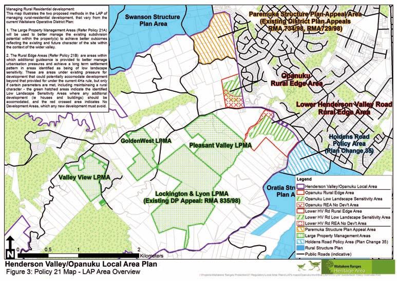
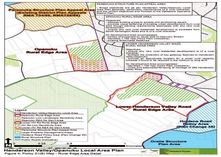
25 5. The Henderson Valley/Opanuku objectives, policies and actions COnTInueD O. HENdERSON VALLEy/OPANUkU LOCAL AREA PLAN OBJECTIVES TO PROTECT, RESTORE ANd ENHANCE: O3 Management of Subdivision, development and Rural Character O3.1 To recognise that, in protecting the area s character, amenity and heritage features, Henderson Valley/Opanuku has little capacity to absorb further subdivision. O3.2 To ensure that any subdivision or development in Henderson Valley/Opanuku, of itself and in respect of its cumulative effect: (i) is of an appropriate character, scale and intensity to retain rural character; (ii) maintains a low density rural community and a pattern of rural holdings; (iii) Does not adversely impact on the visual edge between urban and rural character along the boundary with the Auckland metropolitan area; (iv) does not adversely affect the area s heritage features; (v) does not contribute to urban sprawl; and (vi) contributes to the achievement of the future character and amenity statement. P. P OLICIES A. ACTIONS PROMOTINg THE OBJECTIVES P20. use the definition of future character and amenity as goals to be achieved to avoid cumulative adverse effects on rural character, including in the assessment of relevant Resource Consents and District Plan Changes. P21. Henderson Valley/Opanuku will remain a rural area. Development of a Structure Plan is not necessary to manage subdivision. Instead, subdivision will be managed by retaining the existing District Plan subdivision provisions applying to the Valley apart from those limited opportunities within areas identified on Figure 3 and described below; P21A: Large Properties: A site specific approach will be taken, within the existing capacity limits provided by the Waitakere City Operative District Plan (2003), on identified Large Property Management Areas (see Figure 3) to: (i). protect, restore and enhance heritage features; (ii). promote the retention of rural character and the productive use of rural land; (iii). encourage the retention and appropriate use of cultural landscapes; (iv). ensure that building platforms and associated development areas are carefully located to avoid undermining sensitive and clearly visible landscape features (such as ridges); (v). use location appropriate planting to minimise the visual impact of new development; (vi). provide opportunities where appropriate for the consolidation and/or clustering of development into less visible locations so as to leave significant areas of land available for productive rural activities and/or to minimise the effect of development on sensitive landscapes; A34. Review, extend or modify the relevant Council Codes of Practice and Infrastructure Standards to provide for rural infrastructure standards appropriate to maintain rural character, and to reinforce Local Area Plan policy, and ensure these standards or criteria are reflected in the relevant District Plan. A44. encourage the use of innovative tools (including rates exemptions, rebates or reductions, targeted land purchases, leasing and covenants) to protect, restore and enhance rural and cultural landscapes and heritage features. A45. Develop and produce design, character and location guidelines for buildings and structures, including roadside gates and fences, on the manner in which development and redevelopment can contribute to or defeat the maintenance of rural character. A46. Where appropriate seek innovation in rural design such as clustering, shared ownership, or other methods to protect, restore and enhance rural character. A47. Amend the relevant District Plan subdivision policies and provisions to give effect to Policies P20 and P21(A) in the short to medium term, and Policy 21(B) in the medium to long term. (Note that long term in the context of this LAP is 50+ years) A48. ensure that all development is designed and located to maintain an open rural character in the lower Valley. A49. ensure that all development is designed and located to maintain a dominant forest cover character and roadscapes in the upper Valley. A50. ensure that all development is designed and located to maintain a rural lane character in the residential enclaves. 25
26 5. The Henderson Valley/Opanuku objectives, policies and actions COnTInueD 26 O. HENdERSON VALLEy/OPANUkU LOCAL AREA PLAN OBJECTIVES TO PROTECT, RESTORE ANd ENHANCE: P. P OLICIES A. ACTIONS PROMOTINg THE OBJECTIVES (vii). minimise driveways running laterally across exposed slopes and promote the sharing of access and other infrastructure; (viii). maintain rural roadscapes and landscapes; (ix). manage building design and appearance where widely visible; (x). protect and enhance remnant indigenous vegetation, and connect these remnants with restored and replanted stream riparian margins; (xi). where appropriate, establish rural public walking trails, and (xii). ensure the pattern of resulting settlement is permanent through consent notices or other similar legal mechanisms. P21(B). Rural Edge Areas: in identified Rural edge Areas (see Figures 3 and 4) activities (including subdivision) will be managed to: (i). maintain a rural character (ii). avoid further development within the no Development Areas as shown on Figure 3; (iii). maintain a permanent contrast between urban and rural, and (iv). achieve the relevant matters outlined in Policy 21(A) above. P22. Avoid development which requires the establishment of reticulated wastewater infrastructure, or exacerbates flooding or geotechnical hazards. P23. Avoid the establishment of transport or roadside infrastructure of an urban scale, form or style in Henderson Valley/Opanuku. P24. In the pastoral areas of the Valley, encourage the retention of remnant exotic vegetation (excluding identified pest weed species), and the planting of appropriate exotic vegetation, including shelter belts, vines and fruit trees in addition to indigenous species. P25. Maintain rural roadscapes by requiring new dwellings to be set back from roads and maintain productive rural uses and/or vegetation between the road and the new dwelling. A51. In the pastoral areas of the Valley, ensure that where subdivision or development occurs, provision is made for the management of remnant exotic vegetation including the planting of new shelter belts and exotic vegetation utilising appropriate species, in addition to any required native restoration and enhancement. A52. ensure that when subdivision occurs, the pattern of settlement resulting is secured in perpetuity through consent notices or other similar permanent legal mechanisms. A53. Where utilising Policy 21A(vi) (Clustering), a management plan shall be provided with the subdivision application to show how the cadastral pattern resulting will enable the retention, protection, or enhancement of existing productive rural activities (including pastoral grazing), or the potential for productive rural activities, in the long term. A54. encourage and enable the use of financial incentives (including rates relief, rebates or remissions; covenanting, leaseback arrangements and similar) where appropriate to secure the protection, restoration and enhancement of distinctive rural, cultural or natural features and landscapes. A55. Council s approach to the settlement of the Paremuka Structure Plan Appeal (RMA734/98 and RMA729/98) will seek to apply the relevant principles outlined in Policy 21, and the other relevant Objectives, Policies and Actions of this Local Area Plan.

27 5. The Henderson Valley/Opanuku objectives, policies and actions COnTInueD O. HENdERSON VALLEy/OPANUkU LOCAL AREA PLAN OBJECTIVES TO PROTECT, RESTORE ANd ENHANCE: O4 Implementation O4.1 To be active in the implementation and communication of the Local Area Plan. P. P OLICIES A. ACTIONS PROMOTINg THE OBJECTIVES P26. Improve the ability to discuss opportunities with landowners for property management plans by appointing a broker to manage landowner relationships with the Council. P27. Support existing and new community groups to implement relevant aspects of the Local Area Plan and to advocate for the achievement of the Future Character and Amenity Statements and the Objectives, Policies and Actions of this Local Area Plan. A56. Prepare an implementation and funding plan for the Local Area Plan to contribute towards the development of Annual Plans and Long Term Council Community Plans, and other regulatory plans including the District Plan. A57. ensure the establishment of a first point of contact and coordinator at the Council for all enquiries in relation to the Local Area and LAP, and to ensure all decisions, actions and activities undertaken by the Council in the area, support the achievement of the Local Area Plan in an integrated manner. 27
28
29

30 Henderson Valley School Student Arts Project, based on the question: What do you like about Henderson Valley?
Oratia Local Area Plan. A Long Term Plan for the Character and Amenity of Oratia
 Oratia Local Area Plan A Long Term Plan for the Character and Amenity of Oratia Adopted 3 December 2009 2 The future of Oratia The Oratia Local Area Plan presents the outcome of a series of conversations,
B4. Te tiaki taonga tuku iho - Natural heritage
 B4. Te tiaki taonga tuku iho - Natural heritage Tuia I runga, tuia i raro, tuia ki te waonui a Tiriwa Bind the life forces of heaven and earth to the great realm of Tiriwa B4.1. Issues Auckland s distinctive
Chapter 3: Natural Environment. Proposed Waikato District Plan Stage 1. (Notified version)
") Chapter 3: Natural Environment Proposed Waikato District Plan Stage 1 Page 2 of 7 Contents Chapter 3: Natural Environment... 3 3.1 Indigenous Vegetation and Habitats... 3 3.1.1 Objective Biodiversity and
Chapter 3: Natural Environment Proposed Waikato District Plan Stage 1 Page 2 of 7 Contents Chapter 3: Natural Environment... 3 3.1 Indigenous Vegetation and Habitats... 3 3.1.1 Objective Biodiversity and
3. STATEMENTS OF DESIRED CHARACTER FOR PLANNING AREAS AND PRECINCTS
 3.30 Planning Area No. 30 Mary River Valley 3.30.1 Location and Role This Planning Area encompasses rural lands in the western part of the Shire. These lands are located within the catchment area of the
LANDSCAPE GUIDELINES. Countryside & Coastal Countryside Environments. Landscape, Natural Character & Amenity Values Guide
 Landscape, Natural Character & Amenity Values Guide Copyright WDC 2009 Version A2 18May09 Environmental Services Group Publication Countryside & Coastal Countryside Environments START HERE Quality Land
RURAL ZONE - POLICY. Rural Zone Policy. Issue: Rural Environment. Ruapehu District Plan Page 1 of 8
 Rural Zone Policy RU2 RURAL ZONE - POLICY RU2.1 Introduction The natural resources of the rural environment in the Ruapehu District provide the basis for the existing and potential character, intensity
I611. Swanson North Precinct
 I611. Swanson North Precinct I611.1. Precinct Description Swanson North is located in the north eastern foothills of the Waitakere Ranges. It is outside the Waitakere Ranges Heritage Area Act and the Waitakere
Section 3b: Objectives and Policies Rural Environment Updated 19 November 2010
 Page 1 of Section 3b 3b RURAL ENVIRONMENT 3b.1 Introduction The Rural Environment comprises all the land outside of the Residential, Town Centre and Industrial Environments. Most land within the District
H7 Open Space zones. (a) provide for the needs of the wider community as well as the needs of the community in which they are located;
 provide for the needs of the wider community as well as the needs of the community in which they are located;") H7. Open Space zones H7.1. Background The majority of land zoned as open space is vested in the Council or is owned by the Crown. However some areas zoned open space are privately owned. While the open
H7. Open Space zones H7.1. Background The majority of land zoned as open space is vested in the Council or is owned by the Crown. However some areas zoned open space are privately owned. While the open
Tāhuhu whakaruruhau ā-taone The sheltering ridge pole
 B2. Tāhuhu whakaruruhau ā-taone - Urban growth and form B2.1. Issues Tāhuhu whakaruruhau ā-taone The sheltering ridge pole Auckland s growing population increases demand for housing, employment, business,
4 RESIDENTIAL ZONE. 4.1 Background
 4 RESIDENTIAL ZONE 4.1 Background The residential areas within the City are characterised by mainly lowrise dwellings sited on individual allotments. Past architectural styles, settlement patterns and
Plan Modification to Chapter B2 of the Auckland Unitary Plan(AUP) Operative in part (15 November 2016)
 Operative in part (15 November 2016)") UNITARY PLAN UPDATE REQUEST MEMORANDUM TO FROM Phill Reid Linley Wilkinson DATE 25 September 2018 SUBJECT Plan Modification to Chapter B2 of the Auckland Unitary Plan(AUP) Operative in part (15 November
UNITARY PLAN UPDATE REQUEST MEMORANDUM TO FROM Phill Reid Linley Wilkinson DATE 25 September 2018 SUBJECT Plan Modification to Chapter B2 of the Auckland Unitary Plan(AUP) Operative in part (15 November
I615. Westgate Precinct
 I615. Westgate Precinct I615.1. Precinct Description The Westgate Precinct is located approximately 18km west of the Auckland city centre. There are seven Sub-precincts in the Westgate Precinct: Sub-precinct
The Proposed Auckland Unitary Plan (notified 30 September 2013)
") 7 West 7.1 Avondale 1 The objectives and policies of the underlying Mixed Use zone apply in the following precinct unless otherwise specified. Refer to planning maps for the location and extent of the
7 West 7.1 Avondale 1 The objectives and policies of the underlying Mixed Use zone apply in the following precinct unless otherwise specified. Refer to planning maps for the location and extent of the
3. Highway Landscaping Assessment
 Guidelines for Highway Landscaping 3-1 3. Highway Landscaping Assessment 3.1 Introduction This section outlines the steps necessary to assess the highway landscaping component of a state highway construction
Types of Reserves. Recreational activities
 VALLEY FLOOR AND EASTERN HILLS Physical and ecological features Large, flat valley floor and river plain with intensive urban development Hutt River / Te Awa Kairangi and tributaries Waiwhetu Stream Eastern
SECTION ONE North East Industrial Zone Design Guide Palmerston North City Council June 2004
 SECTION ONE North East Industrial Zone Design Guide Palmerston North City Council June 2004 young heart easy living 1 Preface Industrial areas are a very important component of the economic well-being
Appendix A. Planning Processes. Introduction
 1 Planning Processes Introduction This appendix outlines a number of planning processes which are used in the Auckland Region to support the effective management of development in the region s rural and
GIBBSTON CHARACTER ZONE. QLDC PROPOSED DISTRICT PLAN [PART FOUR] AUGUST gibbston character zone
![GIBBSTON CHARACTER ZONE. QLDC PROPOSED DISTRICT PLAN [PART FOUR] AUGUST gibbston character zone](/thumbs/75/72573993.jpg "GIBBSTON CHARACTER ZONE. QLDC PROPOSED DISTRICT PLAN [PART FOUR] AUGUST gibbston character zone") 23 GIBBSTON CHARACTER ZONE QLDC PROPOSED DISTRICT PLAN [PART FOUR] AUGUST 2015 23 gibbston character zone QLDC PROPOSED DISTRICT PLAN [PART FOUR] AUGUST 2015 23 gibbston character zone 23.1 Zone Purpose
23 GIBBSTON CHARACTER ZONE QLDC PROPOSED DISTRICT PLAN [PART FOUR] AUGUST 2015 23 gibbston character zone QLDC PROPOSED DISTRICT PLAN [PART FOUR] AUGUST 2015 23 gibbston character zone 23.1 Zone Purpose
1 INTRODUCTION TO NATURAL ENVIRONMENT
 Kāpiti Coast District Plan Review Section 32 Analysis Summary Report 1 INTRODUCTION TO NATURAL ENVIRONMENT Diverse landscapes, plants and animals make up the natural environment of the District. Much has
Section 6A 6A Purpose of the Natural Features and Landscapes Provisions
 Section 6A 6A Purpose of the Natural Features and Landscapes Provisions This Chapter addresses the protection and management of natural features and landscapes within the City. The City has a number of
CA.1 Coastal Area. Index. CA.1.1 Description and Expectations
 Index.1.2.3.4 CA.2 CA.2.1 CA.2.2 CA.2.3 CA.3 CA.3.1 CA.3.2 CA.3.1 CA.4 CA.4.1 CA.4.2 CA.4.3 CA.4.4 CA.5 CA.5.1 CA.5.2 Description and Expectations Objectives Policies Guidance Note Landuse Eligibility
The Proposed Auckland Unitary Plan (notified 30 September 2013)
") 3 Business zones Introduction There are 10 business zones in the Unitary Plan: City Centre Metropolitan Centre Town Centre Local Centre Neighbourhood Centre Mixed Use General Business Business Park Light
3 Business zones Introduction There are 10 business zones in the Unitary Plan: City Centre Metropolitan Centre Town Centre Local Centre Neighbourhood Centre Mixed Use General Business Business Park Light
2A District-wide Policies
 2A Introduction This Chapter contains policies which are relevant to subdivision, use and development activities occurring across all zones and areas of the District. The policies in this Chapter implement
I511. Hatfields Precinct
 I511. Hatfields Precinct I511.1. Precinct Description The Hatfields Precinct is a contiguous 183.8 hectare block of rural land held in 8 freehold titles, located immediately to the north of Hatfields Beach.
Rural (Urban Expansion) Environment
 Environment") RUEE.1 Rural (Urban Expansion) Environment Subsequent to the receipt of appeals, a 'marked up' version of the Proposed District Plan was prepared. The provisions of the Proposed Version of the Plan subject
RUEE.1 Rural (Urban Expansion) Environment Subsequent to the receipt of appeals, a 'marked up' version of the Proposed District Plan was prepared. The provisions of the Proposed Version of the Plan subject
6 Landsc apes and rur al char ac
 LANDSCAPES AND RURAL CHARACTER QLDC PROPOSED DISTRICT PLAN [PART TWO] DECISION VERSION ter 6 Landsc apes and rur al char ac 6.1 Purpose Appendix C QLDC DISTRICT PLAN [PART TWO] DECISION VERSION 6 Landsc
QLDC PROPOSED DISTRICT PLAN [PART FOUR] NOVEMBER WAKATIPU BASIN WAKATIPU BASIN
![QLDC PROPOSED DISTRICT PLAN [PART FOUR] NOVEMBER WAKATIPU BASIN WAKATIPU BASIN](/thumbs/82/85315845.jpg "QLDC PROPOSED DISTRICT PLAN [PART FOUR] NOVEMBER WAKATIPU BASIN WAKATIPU BASIN") QLDC PROPOSED DISTRICT PLAN [PART FOUR] NOVEMBER 2017 24 WAKATIPU BASIN 24 WAKATIPU BASIN QLDC PROPOSED DISTRICT PLAN [PART FOUR] NOVEMBER 2017 24 WAKATIPU BASIN 24.1 Zone Purpose This chapter applies
QLDC PROPOSED DISTRICT PLAN [PART FOUR] NOVEMBER 2017 24 WAKATIPU BASIN 24 WAKATIPU BASIN QLDC PROPOSED DISTRICT PLAN [PART FOUR] NOVEMBER 2017 24 WAKATIPU BASIN 24.1 Zone Purpose This chapter applies
I602. Birdwood Precinct
 I602. Birdwood Precinct I602.1. Precinct description The Birdwood Precinct applies to an area west of Don Buck Road and south of Red Hills Road in west Auckland. It incorporates subdivision and development
I609. Penihana North Precinct
 I609. Penihana North Precinct I609.1. Precinct description The Penihana North Precinct is located south of the Swanson Railway Station, adjacent to the Rural Urban Boundary (RUB) and Waitakere Ranges Heritage
UNIVERSITY TOWN NEIGHBOURHOODS 5.2 ECO-CORRIDOR MELBOURNE CAMPUS MASTER PLAN 2014
 5.2 ECO-CORRIDOR 37 ECO-CORRIDOR EXISTING CONDITIONS & VISION NEIGHBOURHOOD VISION Investment in the Eco-corridor Neighbourhood will signify the University s commitment to supporting local ecology and
Rural (Urban Expansion) Environment
 Environment") RUEE.1 Rural (Urban Expansion) Environment Index RUEE.1 RUEE.1.1 RUEE.1.2 RUEE.1.3 RUEE.1.4 RUEE.2 RUEE.2.1 RUEE.2.2 RUEE.2.3 RUEE.2.4 RUEE.3 Rural (Urban Expansion) Environment Description and Expectations
RUEE.1 Rural (Urban Expansion) Environment Index RUEE.1 RUEE.1.1 RUEE.1.2 RUEE.1.3 RUEE.1.4 RUEE.2 RUEE.2.1 RUEE.2.2 RUEE.2.3 RUEE.2.4 RUEE.3 Rural (Urban Expansion) Environment Description and Expectations
Proposed Southland District Plan 2012 Appeal Version October 2016
 S e c t i o n 3. 5 - F i o r d l a n d / R a k i u r a Z o n e The Fiordland/Rakiura Zone encompasses the Fiordland and Rakiura National Parks and part of Mt Aspiring National Park. It also includes areas
CITY VIEW OBJECTIVES
 SECTION 2: CITY VIEW OBJECTIVES CONTENTS 2.1 Introduction 1 2.2 Strategic Direction 1 2.3 The City View Resource Management Issues for the City 1 2.4 The Goal 3 2.5 The City View Objectives 3 Palmerston
Cotswolds AONB Landscape Strategy and Guidelines. June 2016
 Cotswolds AONB Landscape Strategy and Guidelines June 2016 Cotswolds AONB Landscape Strategy and Guidelines Introduction The evolution of the landscape of the Cotswolds AONB is a result of the interaction
7. Landscape. Introduction
 Introduction Our landscapes provide us with a Marlborough identity and are an integral part of the Marlborough environment. Landscapes are distinct spatial areas influenced by location-specific processes
PART 5 - NATURAL AND PHYSICAL ENVIRONMENT
 CONTENTS...PAGE 5.1 INTRODUCTION...3 5.2 NATURAL RESOURCES...4 5.3 PHYSICAL RESOURCES...4 5.4 COASTAL ENVIRONMENT...4 5.5 HERITAGE FEATURES...4 5.6 HAZARDS...4 5.7 SUMMARY...4 ISTHMUS SECTION - OPERATIVE
I412. Flat Bush Precinct
 I412. Flat Bush Precinct I412.1. Precinct description The Flat Bush precinct covers approximately 1730ha of land adjacent to the Rural Urban Boundary. The Flat Bush Precinct incorporates the provisions
Section 12C Subdivision in the Rural Residential Zone
 Section 12C 12C Subdivision in the Rural Residential Zone The Rural Residential Zone provides part of the range of residential opportunities within the City. Land zoned rural residential is considered
Appendix 1 Structure plan guidelines
 Appendix 1 Structure plan guidelines This appendix forms part of the regional policy statement [rps]. 1.1. Introduction Structure plans are an important method for establishing the pattern of land use
4 Residential and Urban Living Zones
 4 Residential and Urban Living Zones Refer to Chapters 11 to 20 for additional rules that may apply to these zones. 4.1 OBJECTIVES AND POLICIES Objective Res1 Policy 1 Policy 2 Policy 3 Policy 4 Policy
The Proposed Auckland Unitary Plan (notified 30 September 2013)
") 8 Special Purpose zones 8.1 Airport zone The Airport zone applies to the Kaipara Flats Airfield, North Shore Airfield, Auckland International Airport and Ardmore Airport. Auckland International Airport
8 Special Purpose zones 8.1 Airport zone The Airport zone applies to the Kaipara Flats Airfield, North Shore Airfield, Auckland International Airport and Ardmore Airport. Auckland International Airport
E15. Vegetation management and biodiversity
 E15. management and biodiversity E15.1. Background contributes to a range of ecosystem services such as erosion and sediment control, reducing stormwater flows, protecting or enhancing water quality, amenity
Rural Subdivision and Development
 Rural Subdivision and Development Design Guidelines MAY 2012 1 Rural Subdivision and Development Design Guidelines 2The open spaciousness of the rural environment in the foreground of Mount Taranaki from
QUEENSTOWN LAKES DISTRICT COUNCIL SUBDIVISION DESIGN GUIDELINES
 Attachment C: Draft QLDC Subdivision Design Guidelines QUEENSTOWN LAKES DISTRICT COUNCIL DESIGN GUIDELINES A DESIGN GUIDE FOR AND DEVELOPMENT IN THE URBAN ZONES QUEENSTOWN OFFICE 10 Gorge Road Queenstown
Northland Regional Landscape Assessment Worksheet
 Northland Regional Landscape Assessment Worksheet DESCRIPTION AND CHARACTERISATION Component Land Types (refer to list overleaf) Volcanic cones Geology (including geopreservation sites) Soil Types Unit
STRATEGIC DIRECTION. QLDC PROPOSED DISTRICT PLAN [PART TWO] DECISIONS VERSION 3 strategic direction
![STRATEGIC DIRECTION. QLDC PROPOSED DISTRICT PLAN [PART TWO] DECISIONS VERSION 3 strategic direction](/thumbs/79/79711764.jpg "STRATEGIC DIRECTION. QLDC PROPOSED DISTRICT PLAN [PART TWO] DECISIONS VERSION 3 strategic direction") 3 STRATEGIC DIRECTION QLDC PROPOSED DISTRICT PLAN [PART TWO] DECISIONS VERSION 3 strategic direction QLDC DISTRICT PLAN [PART TWO] AUGUST 2015 3 strategic direction 3.1 Purpose This chapter sets out the
3 STRATEGIC DIRECTION QLDC PROPOSED DISTRICT PLAN [PART TWO] DECISIONS VERSION 3 strategic direction QLDC DISTRICT PLAN [PART TWO] AUGUST 2015 3 strategic direction 3.1 Purpose This chapter sets out the
Scottish Natural Heritage. Better places for people and nature
 Scottish Natural Heritage Better places for people and nature Contents Summary... 3 SNH approach... 5 Place-making in policy and practice... 6 Developing the contribution of the natural heritage to place-making...
I403 Beachlands 1 Precinct
 I403. Beachlands 1 I403.1. Precinct Description Beachlands is a rural and coastal village located on the eastern side of Auckland, adjoining the Tamaki Strait coastline. The original Beachlands village
Extract from Whitehorse Planning Scheme - LOCAL PLANNING POLICIES - CLAUSE Preferred Character Statements
 Extract from Whitehorse Planning Scheme - LOCAL PLANNING POLICIES - CLAUSE 22.03 22.03-5 Preferred Character Statements Bush Environment The streetscapes will be dominated by vegetation with subservient
SUSTAINABLE MANAGEMENT
 . Sustainable Management.1 The Concept of Sustainable Management The concept of sustainable management recognises there are limits to the use of natural and physical resources and there is a need to balance
DRAFT Amsterdam/Churchill Community Plan (4/17/08) Adopted By the Gallatin County Commission
 Adopted By the Gallatin County Commission") DRAFT Amsterdam/Churchill Community Plan (4/17/08) Adopted By the Gallatin County Commission Table of Contents Acknowledgements Chapter 1: Introduction A Brief History What s Next Authority Organization
DRAFT Amsterdam/Churchill Community Plan (4/17/08) Adopted By the Gallatin County Commission Table of Contents Acknowledgements Chapter 1: Introduction A Brief History What s Next Authority Organization
Appendix H: Easement cross sections
 Appendix H: Easement cross sections SHARED PATH 1.5m FOOTPATH NATURE STRIP 7.3m CARRIAGEWAY 2.7m NATURE STRIP EXISTING PIPELINE 150mm DIA 5.0m (approx.) LOCAL ACCESS ROAD EXISTING PIPELINE 500mm DIA 2.7m
Wind energy development in the South Pennines landscape
 Wind energy development in the South Pennines landscape Programme for today Background Policy context South Pennines landscape Impacts of wind energy development The South Pennines Wind Energy Landscape
SECTION 2.4 URBAN DEVELOPMENT AND STRATEGIC URBAN DIRECTIONS
 SECTION 2.4 URBAN DEVELOPMENT AND STRATEGIC URBAN DIRECTIONS 2.4.1 INTRODUCTION In 1993/94 the Hastings District Council completed the Hastings Urban Development Strategy. The purpose of this study was:
Northland Regional Landscape Assessment Worksheet
 Northland Regional Landscape Assessment Worksheet Unit name TE POUAHI HEADLAND DESCRIPTION AND CHARACTERISATION Component Land Types (refer to list overleaf) Dune complex Coastal cliffs / escarpment Reefs
Glenn Highway MP DSR. Landscape Narrative
 Glenn Highway MP 34-42 DSR Landscape Narrative Project Landscape Goals The Glenn Highway MP 34-42 Project extends through a variety of landscape types typical to the Matanuska-Susitna Valley. In general,
Section Three, Appendix 16C Medium Density Housing, Design Assessment Criteria (Residential 8A zone)
") APPENDIX 16C MEDIUM DENSITY HOUSING, DESIGN ASSESSMENT CRITERIA (RESIDENTIAL 8A ZONE) PURPOSE OF APPENDIX 16C (RESIDENTIAL 8A ZONE) In the Residential 8A Zone the following are defined as restricted discretionary
APPENDIX 16C MEDIUM DENSITY HOUSING, DESIGN ASSESSMENT CRITERIA (RESIDENTIAL 8A ZONE) PURPOSE OF APPENDIX 16C (RESIDENTIAL 8A ZONE) In the Residential 8A Zone the following are defined as restricted discretionary
7.2.9 Eudlo local plan code
 7.2.9 local plan code 7.2.9.1 Application (1) This code applies to assessable development:- (a) within the local plan area as shown on Map ZM29 contained within Schedule 2 (Mapping); and (b) identified
8.0 Design and Form of Development 43/
 42/ 8.0 Design and Form of Development 43/ Rothwells Farm, Golborne/ Development Statement Figure 7. Site Constraints Key 44/ Site Boundary 360 Bus Route/Stops Existing Trees Underground Water Pipe Sensitive
INCREMENTAL CHANGE AREA REVIEW March 2015 Page 1
 INCREMENTAL CHANGE AREA REVIEW March 2015 Page 1 Table of Contents Introduction... 3 Background to Review... 3 Comparison of the Schedules to the General Residential Zone... 7 Methodology... 7 Policy Context...
Ensure that development within the Arrowtown Urban Growth Boundary provides:
 URBAN DEVELOPMENT 4 4.2.5.2 Ensure that development within the Arrowtown Urban Growth Boundary provides: an urban form that is sympathetic to the character of Arrowtown, including its scale, density, layout
I539. Smales 2 Precinct
 I539. Smales 2 Precinct I539.1. Precinct Description The Smales 2 Precinct applies to a 4.8 hectare block of land located on the southern side of Northcote Road and fronting Lake Pupuke, Takapuna. The
Landscape Assessment CEUGP/SR9B
 Landscape Assessment CEUGP/SR9B TABLE OF CONTENTS 1 STUDY PHILOSOPHY... 3 2 GENERAL DESCRIPTION OF SITE... 4 3 LANDSCAPE THEMES... 8 TABLE OF FIGURES Table 1: Landscape... 5 Table 2: Landscape Themes...
4.1.3 LAND USE CATEGORIES
 4.1.3 LAND USE CATEGORIES a. City Center District The City Center District incorporates the existing character and mix of uses in downtown Belmont to encourage redevelopment and new development in keeping
10.0 Open Space and Public Realm
 10.0 Open Space and Public Realm 10.0 Open Space and Public Realm The Public Open Space System is comprised of: outdoor spaces available for public use that are either publicly owned (e.g., parks and
Understanding Wellington City s DISTRICT PLAN
 Understanding Wellington City s DISTRICT PLAN Wellington City Council 1 UNDERTANDING WELLINGTON CITY S DISTRICT PLAN CONTENTS 1. Introduction...3 1.1. Overview of this Guide...3 1.2. What is the District
TIDAPA Structure Plan
 TIDAPA Structure Plan Prepared by Tract Consultants 28 MARCH 2017 0217-0074 Table of Contents 01 STRATEGIC CONTEXT Executive Summary Regional Context Page 3 Page 4 02 LOCAL CONTEXT Aerial Photograph Local
Issue 1 Protection of the special environmental qualities of the Hanmer Basin.
 Environments of special concern Issue 19 Hanmer Basin The Hanmer Basin is a special area, being a popular retirement and holiday destination as well as having considerable environmental and conservation
REMARKABLES PARK ZONE
 .10 Remarkables Park Zone.10.1 Resources, Activities and Values The Remarkables Park Area comprises approximately 150 hectares of perimeter urban land in the vicinity of Frankton and occupies a strategic
open space environment
 This section updated August 09 GUIDELINE TO THE RULES The Open Space Environment Rules apply to activities on sites within the Open Space Environment as shown on the Human Environments Maps. Most of the
I541. Te Arai North Precinct
 I541. Te Arai North Precinct I541.1. Precinct Description The Te Arai North Precinct contains approximately 616ha of coastal land north of Te Arai Point, generally known as Mangawhai North Forest. The
I326. Ōrākei 1 Precinct
 I326. Ōrākei 1 recinct I326.1. recinct Description The Ōrākei 1 recinct includes the land identified as hapu reservation (land held for the purposes of a marae, church, urupa and related hapu amenities)
THREE-STEP DESIGN PROCESS FOR OPEN SPACE SUBDIVISIONS
 00216106.DOC NMA/RRK 1/30/14 THREE-STEP DESIGN PROCESS FOR OPEN SPACE SUBDIVISIONS Open space subdivisions, sometimes called cluster developments, maintain a significant portion of a development site in
97 Lea Bridge Road, Leyton, E10 7QL London Borough of Waltham Forest December 2015
 97 Lea Bridge Road, Leyton, E10 7QL London Borough of Waltham Forest December 2015 Public Realm and Landscape Proposals LEA BRIDGE ROAD, WALTHAMSTOW Public Realm & Landscape Proposals BDP(90)RPT001 December
HOROWHENUA DEVELOPMENT PLAN June create a safe crossing for children moving to and from the school and other areas. 7.8 Ohau
 7.8 Ohau create a safe crossing for children moving to and from the school and other areas. Ohau has a traditional village form with a collective of school, church and reserve at the main road intersection.
A Growing Community Rural Settlement Areas
 Town of Huntsville Official Plan Review - POLICY BACKGROUND PAPER A Growing Community Rural Settlement Areas BACKGROUND: In addition to the fully municipally-serviced Urban Settlement Area and the Hidden
CHAPTER 5: GUIDING PRINCIPLES
 CHAPTER 5: GUIDING PRINCIPLES The following 10 principles were developed based on public consultation, planning policy and the background analysis conducted during Phase 1. The Guiding Principles significantly
GREENBANK DEVELOPMENT MASTERPLAN
 DEVELOPMENT MASTERPLAN POTENTIAL TRAIN STATION COMMUNITY CENTRE Greenbank will be a connected masterplanned community providing easy access to local and surrounding amenity. Affordable quality homes, green
Northland Regional Landscape Assessment Worksheet
 Northland Regional Landscape Assessment Worksheet DESCRIPTION AND CHARACTERISATION Component Land Types Northern and eastern dissected hills; moderate to high relief land type Unit name NORTH EAST BUSH
SQUAMISH 2010 AND BEYOND COMMUNITY VISION
 Our plan has been imagined and created to be both pragmatic and visionary. At the core of the strategy is a consideration of the highway s role and its impact on the community. First and foremost in creating
39 WALLACEVILLE STRUCTURE PLAN
 39 WALLACEVILLE STRUCTURE PLAN PRECINCT DESCRIPTIONS, INTENTIONS AND OUTCOMES Wallaceville Living Precinct Area A At approximately 13.4ha, this precinct is the largest precinct and the precinct provides
COMMUNITY DESIGN. GOAL: Create livable and attractive communities. Intent
 COMMUNITY DESIGN Intent An attractive, well-designed County will attract quality development, instill civic pride, improve the visual character of the community, and create a strong, positive image for
Mollers Lane, Leopold, Victoria Significant Landscape Overlay Re-assessment
 XURBAN Mollers Lane, Leopold, Victoria Significant Landscape Overlay Re-assessment For: TGM Group November 2016 Final Mollers Lane, Leopold, Victoria Significant Landscape Overlay Re-assessment Client
Taking forward the All London Green Grid
 Taking forward the All London Green Grid Foreword Earlier this year, the Mayor published the All London Green Grid Supplementary Planning Guidance to the London Plan which set the vision, and framework,
H1. Residential Large Lot Zone
 H1. Residential Large Lot Zone H1.1. Zone description The Residential Large Lot Zone provides for large lot residential development on the periphery of urban areas. Large lot development is managed to
Exhibit A. 8:9 Scuffletown Rural Conservation District
 Exhibit A 8:9 Scuffletown Rural Conservation District 8:9.1 Intent and Purpose The Scuffletown Rural Conservation (SRC) District is intended to provide for residential development that supports the development
I542. Te Arai South Precinct
 I542. Te Arai South Precinct I542.1. Precinct Description The Te Arai South Precinct contains approximately 750ha of coastal land south of Te Arai Point, known as Mangawhai South Forest. The land within
EXECUTIVE SUMMARY DRAFT CHAPTER 1 INTRODUCTION EXECUTIVE SUMMARY
 CHAPTER 1 EXECUTIVE SUMMARY INTRODUCTION Through the joint efforts of the City of Tulsa planning staff and the Land Services division of Indian Nations Council of Governments (INCOG), the Berryhill Land
WELLINGTON HOSPITAL DESIGN GUIDE TABLE OF CONTENTS
 WELLINGTON HOSPITAL DESIGN GUIDE TABLE OF CONTENTS 1.0 Introduction Page 2 The Place of Wellington Hospital 2 The Future of the Hospital 2 2.0 The Intention of the Design Guide 3 3.0 Analysis 4 General
2.0 Strategic Context 4
 2.0 Strategic Context 4 2.1 The Area Action Plan is a non-statutory plan, which forms a corporate policy document, expressing particular issues and areas of concern while also providing a vision for the
OVERVIEW (Updated November 2010)
") OVERVIEW (Updated November 2010) The Rural Zone covers most of the peninsula. It extends from the elevated and deeply dissected inland parts of the District to the coastline. Much of it is also part of
OVERVIEW (Updated November 2010) The Rural Zone covers most of the peninsula. It extends from the elevated and deeply dissected inland parts of the District to the coastline. Much of it is also part of
4.3 Dudley Area Plan. Introduction. History and Existing Character. Desired Future Character for Dudley
 4.3 Dudley Area Plan Introduction The suburb of Dudley has developed as a result of various circumstances including its topography, history and mineral resources. Dudley development has been identified
The following principles guide the development of goals and strategies to protect and promote these amenities:
 OPEN SPACE/PARKS/TRAILS/RECREATION GOALS/STRATEGIES Cherry Hills Village is a living environment that offers low density development, open areas, public scenic vistas, public trails and public parks. This
Site Option 3: Te Matai
 Site Option 3: Te Matai Location Napier Drain looking south east Description The Te Matai growth option is located between the existing residential boundary (Ruamahanga Crescent) Napier Road (State Highway
D10. Outstanding Natural Features Overlay and Outstanding Natural Landscapes Overlay
 D10. Outstanding Natural Features Overlay and Outstanding Natural Landscapes Overlay D10.1. Background These provisions give effect to Policy 15(a) of the New Zealand Coastal Policy Statement 2010, and
3. VISION AND GOALS. Vision Statement. Goals, Objectives and Policies
 Vision Statement Queen Creek s interconnected network of parks, trails, open spaces and recreation opportunities provide safe and diverse activities and programs that sustain its unique, small town, equestrian
Design Guidance. Introduction, Approach and Design Principles. Mauritius. November Ministry of Housing and Lands. .. a
 sig evelo r D Mauritius s. Utilities.. Individu a s. er itects.to ls chpers.po e Public. T. h rban D Sc U e me Promot e h ners. A Design Guidance o.h Planne rs n w iticians r l useholde National Development
Subdivision Design Criteria. Penihana North GUIDELINES TO THE RULES
 Created September 2013 Penihana North Subdivision Design Criteria GUIDELINES TO THE RULES This part of the Plan sets out the design criteria for subdivision in Penihana North. The criteria will be considered
A Joined-up Regional Landscape: A Roadmap to connect the parts
 Breaking the Barriers: Engineering Solutions to Ecological Problems A Joined-up Regional Landscape: A Roadmap to connect the parts Associate Professor Darryl Low Choy Urban Research Program Outline Nature