Span McCowan and Market Building Proposal
|
|
|
- Douglas Tyler
- 6 years ago
- Views:
Transcription

1 STAFF REPORT ACTION REQUIRED Span McCowan and Market Building Proposal Date: April 23, 2014 To: From: Wards: Reference Number: Scarborough Community Council Raymond David, Director, Community Planning, Scarborough District Ward 38 Scarborough Centre EPS 00 TM SUMMARY This report responds to a direction from City Council to evaluate the feasibility of constructing a deck park ( Span McCowan ) across McCowan Road between Progress Avenue and Bushby Avenue/Town Centre Court, as well as a stand-alone market building to serve as a specialty retail destination within the Scarborough Centre. The direction originated from Scarborough Community Council following a presentation on Span McCowan by the Glen Andrew Community Association. Following consultation with several City divisions, staff have determined that constructing an elevated deck park above McCowan Road south of Progress Avenue and north of the existing SRT corridor would be technically feasible, and would cost in the order of $40 million, including ongoing maintenance over fifty years. The construction of a 4,400 square metre, stand-alone shell of a building to accommodate an indoor market would cost approximately $1.5 million, not including land acquisition costs or ongoing maintenance. RECOMMENDATIONS The City Planning Division recommends that: 1. Scarborough Community Council receive this report for information. Staff report for information Span McCowan & Market Building Proposal 1
2 Financial Impact While there are no immediate financial impacts arising from this report, it is estimated that the construction of a deck park and a permanent market building would require approximately $41.5 million in capital funding (including deck structure maintenance over a 50-year period, but excluding land acquisition and ongoing operating funding for park and market building maintenance costs). These costs are unfunded as they are not included in the 10-Year Capital Plan or the 2014 Operating Budgets for Transportation Services, Parks, Forestry and Recreation, or any other program. Should City debt funding be proposed, significant re-allocations would be required within the current 10 Year Capital Plan. The Deputy City Manager and Chief Financial Officer has reviewed this report and agrees with the financial impact information. DECISION HISTORY At their July 11-13, 2012 meeting, City Council directed "the Acting Chief Planner and Executive Director, City Planning Division, in consultation with Transportation Services and Parks, Forestry and Recreation staff to review the "Span McCowan" proposal presented by the Glen Andrew Community Association as part of the ongoing McCowan Precinct Plan Study and that its feasibility including cost estimates be reported out in association with the McCowan Precinct Plan Study's Final Report. ISSUE BACKGROUND In December, 2005, Council approved a new secondary plan for the Scarborough Centre. The Secondary Plan includes, in broad terms, the policies and urban design ambitions for the Centre. In June, 2011, staff advised Scarborough Community Council that the City Planning division was initiating a study of the area known as the McCowan Precinct in the Scarborough Centre. The final report for the McCowan Precinct Plan is being brought to the May 13, 2014 meeting of Scarborough Community Council. On June 13, 2012, City Planning staff presented the conclusions and recommendations of the Scarborough Centre Public Space and Streetscape Master Plan for the Civic and Commercial Precincts to Scarborough Community Council. The Master Plan, which was approved by City Council on July 11-13, 2012, establishes a vision for the Civic and Commercial Precincts and identifies seven priority projects and implementation strategies to improve and enhance the public realm and public space framework. A copy of the plan can be found at At the June 13, 2012 meeting, representatives from the Glen Andrew Community Association made a deputation to Scarborough Community Council in response to City Planning staff's report. A copy of their presentation can be found at Two main themes emerged from the community association s presentation: the necessity of safe pedestrian and cycling connections across McCowan Road and the need for a sense of place, or a destination, within the Scarborough Centre. Staff report for information Span McCowan & Market Building Proposal 2
3 Their suggestion to address the first of these two objectives was for the City to consider constructing a deck park above McCowan Road between Progress Avenue and Bushby Drive/Town Centre Court to provide a grade-separated pedestrian and cycling link between the McCowan Precinct and the adjacent Commercial and Civic Precincts, while at the same time increasing the amount of park space in the Centre (refer to Attachment 1: Original Glen Andrew Community Association Proposal). Secondly, they suggested that the City consider constructing a purpose-built market building, similar to the St. Lawrence Market south building, to serve as a permanent, specialty retail destination. Community Council recommended that City Council adopt the recommendations of the Scarborough Centre Public Space and Streetscape Master Plan, and also directed staff to report back on the feasibility of the Span McCowan proposal presented by the Glen Andrew Community Association in conjunction with the McCowan Precinct Plan Study s final report. COMMENTS Site and Surrounding Area The subject area is comprised of the rights-of-way of McCowan Road between Progress Avenue and Bushby Drive/Town Centre Court and the eastern portion of Triton Road terminating at McCowan Road. McCowan Road is a City-owned six-lane arterial road traversing in a northsouth direction and is a major vehicular route to and from Highway 401. The portion of Triton Road east of the Scarborough Town Centre mall is a private street owned by Oxford Properties Group which is reserved primarily for buses, taxis and delivery vehicles serving the Scarborough Centre bus terminal and the Scarborough Town Centre mall. Triton Road and McCowan Road at this location are generally lower in elevation than the surrounding lands, with sloped embankments on all sides. There is a signalized intersection where these two streets meet. There is a sidewalk along the west side of McCowan Road with a TTC bus stop just north of Town Centre Court. There is a sidewalk along the east side that is elevated above street level and separated from McCowan Road by an on-ramp that provides vehicular access northbound onto McCowan Road from Bushby Drive. The south portion of this walkway terminates at the mezzanine level of the McCowan RT station. There is a TTC/Go Transit bus shelter and a 20m-long sidewalk along the south side of Triton Road and a 30m-long sidewalk along the north side, both of which terminate prior to the road becoming tunnelled beneath the Scarborough Town Centre mall parking lot. Abutting uses include: North: South: East: West: Progress Avenue (including an elevated, enclosed pedestrian walkway) Scarborough Rapid Transit (SRT) line, McCowan SRT station (located on the east side of McCowan Road), Bushby Drive/Town Centre Court large, vacant parcel of land at 120 Grangeway Drive (recently sold by Build Toronto to the Goldman Group) Scarborough Town Centre mall surface parking lot owned by Oxford Properties Group Staff report for information Span McCowan & Market Building Proposal 3
4 Scarborough Centre Public Space and Streetscape Master Plan The Span McCowan proposal is located on the eastern edge of both the Civic and Commercial Precincts, and on the western edge of the McCowan Precinct (refer to Attachment 2: Scarborough Centre Secondary Plan). The Scarborough Centre Public Space and Streetscape Master Plan provides direction on public realm projects and strategies to improve the Centre's public space framework for the Civic and Commercial Precincts. It recommends the implementation of several urban design principles to clarify the overall design intent for the Centre s streets and public spaces, one of which describes how arterial streets should be designed as generously landscaped avenues that balance the accommodation, safety and amenity for the various corridor users. McCowan Road is one of three arterial corridors identified in the Plan. The Plan also identifies seven key priority projects to implement the Master Plan and improve the quality and character of public spaces in the Civic and Commercial Precincts including the revitalization of Albert Campbell Square, the redesign of the Civic Green (Ceremonial Plaza) and the redesign of the Civic Common to open up the view corridor from Ellesmere Road toward the Civic Centre building and the new library. The seven priority projects have an estimated total cost of $ million. With a estimated available cash flow of $1.331 million, there is a $ million shortfall for the funding of the key priority projects in the Plan. McCowan Precinct Plan The Scarborough Centre Secondary Plan contemplates the development of detailed Precinct Plans for each of the four precincts. Community Planning staff have completed the McCowan Precinct Plan Study, which has resulted in a detailed plan for the McCowan Precinct. This plan will provide implementation policies, development principles, and design strategies for the McCowan Precinct that will be used to guide change and manage growth, identify necessary public and private realm improvements, identify needs and opportunities for improvements to parks, transportation and community and social services, strengthen the employment base within the precinct, direct infrastructure investment, and provide a foundation for the preparation of any policy amendments for the McCowan Precinct to manage future development. The Conceptual Master Plan identifies the McCowan/Bushby/Progress area as a "Gateway" that experiences high volumes of pedestrian activity. To create an attractive and safe pedestrian environment, provide for safe and functional vehicular movement, and to enhance its function as a gathering place and a connection point between Precincts, the Gateway is to incorporate a variety of design features that may include: clearly defined pedestrian routes that may be grade-related or associated with parks, open spaces and/or transit facilities; greater sidewalk widths, increased landscaped areas and the creation of urban spaces through additional building setbacks; Staff report for information Span McCowan & Market Building Proposal 4
5 widened street medians with pedestrian refuge areas; enhanced streetscape design, way-finding signage and pavement treatment; improved street signalization and street lighting; and land uses and facilities that function as destination elements (eg. transit stations, commercial/institutional uses, etc.) International Examples of Deck Parks There are examples of deck parks in jurisdictions around the world connecting neighbourhoods and public spaces by bridging large spans of roadway with attractive and functional public areas. Such structures have generally been built above deeply entrenched freeways, reconnecting oncecohesive neighbourhoods later cut off by the widespread highway construction boom of the 1950s and 1960s (refer to Attachment 3: Margaret T. Hance Park, Phoenix, Arizona). Some, like Millennium Park in Chicago, have been built above and across extensive rail corridors separating the downtown cores of many such cities from their historic waterfront areas (refer to Attachment 4: Millennium Park, Chicago, Illinois). Others take the form of hardscaped urban squares connecting major attractions. The Terrasse de Pomone in Paris is one example, which spans l Avenue du General Lemonnier to form a continuous park connecting the Jardin des Tuileries, the Champs-Elysees and the Louvre museum (refer to Attachment 5: Terrasse de Pomone, Paris, France). Generally, these deck parks most often link publicly owned spaces that experience high levels of pedestrian traffic. Free-standing deck parks unattached to adjacent public streets or open spaces are seemingly not as common. Consultation with City Divisions The Glen Andrew Community Association proposal, as presented to Community Council in June, 2012, envisioned building a 1.2 hectare (3 acre) deck park above McCowan Road and Triton Road between Progress Avenue and Bushby Drive/Town Centre Court and bisected by the existing SRT line (refer to Attachment 1: Original Glen Andrew Community Association proposal). In order to assess the feasibility of the proposed deck park, City Planning staff consulted with staff from Corporate Finance, Parks, Forestry and Recreation, Engineering and Construction Services, Transportation Services, Facilities and Real Estate Services and the TTC. Because the portion of Triton Road within the study area is privately owned, Planning staff used only the publicly-owned McCowan Road right-of-way in its analysis. Accounting for the presence of the existing elevated SRT structure, the remaining space between the south side of Progress Avenue and the north side of Bushby Drive/Town Centre Court is approximately 41 metres (135 feet) in Staff report for information Span McCowan & Market Building Proposal 5
6 width, 160 metres (525 feet) in length and 6,800 square metres (1.7 acres) in area (refer to Attachment 6: City Study Area). Engineering and Construction Services staff advised City Planning staff that the minimum cost to build a basic concrete overpass structure is approximaely $3,000 per square metre ($280 per square foot). The average cost to maintain such a structure for its typical life span of about fifty years is around $2,160 per square metre ($200 per square foot). It should be noted, however, that Engineering and Construction Services consider any elevated overpass structure beyond 90 metres (295 feet) in length to be a tunnel, and would therefore require that the structure be outfitted with an overhead ventilation system to ensure that automobile exhaust would be adequately dispersed from beneath the structure. At 160 metres (525 feet) in length, the Span McCowan proposal would be considered a tunnel, and would therefore require ventilation. The cost to build an overpass structure with overhead ventilation and associated electrical systems is around $6,500 per square metre ($604 per square foot) plus $10 million in ventilation maintenance over fifty years on top of the maintenance costs for the basic structure. At 6,800 square metres (1.7 acres) in size, a concrete deck structure above McCowan Road between Progress Avenue and Bushby Drive/Town Centre Court with ventilation and electrical systems would cost approximately $44 million. Including maintenance over fifty years, the total cost would be in the order of $69 million (refer to Attachment 10: Cost Estimates). In order to estimate the cost of a park on top of the deck structure, Parks, Forestry and Recreation staff assumed that 50% of the space would be likely comprised of soft landscaping (tree plantings, gardens, grass, mulch, etc.) and the other 50% would be comprised of hard landscaped materials (paving, interlocking brick, concrete walkways, etc.). The estimated base cost for such a park is around $926 per square metre ($86 per square foot) for a total of $6.3 million. No estimate for ongoing maintenance was provided by Parks staff. Added to the cost of a ventilated concrete deck structure, the estimated cost of a deck park above McCowan Road between Bushby Drive/Town Centre Court would be in the order of $51 million. Including the maintenance of the ventilated deck structure over a fifty year period, the estimated total cost would be approximately $75 million. While overpass structures typically have a vertical clearance of around 5 metres (16.5 feet), the presence of the existing overhead traffic signals at the intersection of McCowan Road and Triton Road would require an additional vertical clearance of 2 metres (6.6 feet). In addition, TTC staff advised that a horizontal clearance of 1 metre (3.3 feet) would be required from the elevated SRT corridor in order to avoid the vibration of passing transit vehicles from affecting a deck structure. Accommodating both the vertical clearance for the overhead traffic signals and the horizontal clearance for the SRT structure is technically feasible, but it renders the portion between the elevated SRT structure and Bushby Drive/Town Centre Court too small to be effectively bridged with a deck park. Revised Span McCowan Proposal In April, 2013, City Planning staff met with representatives from the Glen Andrew Community Association to present the above preliminary findings. As a result, the residents group revised their proposal to scale back the length of the proposed structure such that it would be less than 90 Staff report for information Span McCowan & Market Building Proposal 6
7 metres (295 feet) in length, and would therefore not be considered a tunnel requiring an extensive ventilation system (refer to Attachment 7: Revised Glen Andrew Community Association Proposal). The revised proposal, which has a reduced area of around 6,500 square metres (1.6 acres) also abandoned the concept of bridging the small portion above McCowan Road between the elevated SRT structure and Bushby Drive/Town Centre Court. The representatives for the community association expressed a strong desire to bridge over at least a portion of Triton Road, even though it is not publicly owned, as a means to maximize east-west connectivity within the Centre. Using the same parameters as before, albeit with a smaller deck area and no requirement for ventilation systems, the estimated cost for the Glen Andrew Community Association s revised proposal would be in the order of $40 million. This figure includes $19.5 million for a 6,500 square metre (1.6 acre) concrete overpass structure, $14 million for maintenance over a fifty-year period, and $6 million for the construction of a park above, excluding ongoing park maintenance. For a line-item comparison of the original and revised proposals, please refer to Attachment 10: Cost Estimates. 705 Progress Site The McCowan Precinct is in the lowest quintile of parkland provision per capita, as shown on Map B Local Parkland Provision in the Official Plan. There are two existing local parks within the McCowan Precinct - Lee Centre Park and Hillsborough Park. These parks are 0.34 hectares and 0.36 hectares in size, respectively. There is a need for neighbourhood parks that offer a range of features and recreation amenities to local users, such as playing fields, playgrounds, etc. The implementation of new parkland is therefore a priority for this area. The City is the joint owner (along with the TDSB) of a 4.4 hectare (10.9 acre) parcel of land at 705 Progress Avenue, which has been earmarked for a public school and a neighbourhood park (refer to Attachment 8: 705 Progress Avenue Site). This currently industrial site was jointly purchased with the Toronto District School Board in order to increase the amount of parkland within the Scarborough Centre and to secure a large parcel of land to build a future school that the projected increase in population is expected to call for. Staff from Parks, Forestry and Recreation have estimated that the construction of a 2.2 hectare (5.4 acre) park, representing 50% of the joint land holding, would cost around $2.35 million which includes the demolition of existing buildings on the site, construction of playground equipment, water-play facilities, sports fields, pedestrian walkways, tree and shrub plantings, and outdoor furnishings such as benches and garbage receptacles. This estimate includes the costs associated with undertaking Phase 1 and Phase 2 environmental assessments, but does not include any remediation of soils that may be required, as those studies have not yet been conducted. Staff of PFR advise there is no identified funding to support the addition of $2.35 million to the PFR Division's 10 year capital plan. Market Building (Proposal and St. Lawrence Market) The Glen Andrew Community Association presentation to Scarborough Community Council described the need for a destination within the Scarborough Centre which should serve as a focal point for eastern Toronto. Staff report for information Span McCowan & Market Building Proposal 7
8 The community association s suggestion was for a permanent, City-owned market building, similar to the St. Lawrence Market South Building, to be located on a portion of the currently vacant 120 Grangeway Drive site on the east side of McCowan Road. They envisioned the building as a place for Scarborough s independent food merchants to gather and sell their goods that could extend outside onto the deck park spanning McCowan Road on a seasonal basis. The building could also double as a community space with child care facilities. The ground floor of the St. Lawrence Market South Building is approximately 4,400 square metres (47,000 square feet). In consultation with Facilities and Real Estate Services staff, it was estimated that a building with a similarly-sized ground floor would cost around $1.3-$1.4 million. This estimate assumes a big box format retail building with very basic detailing, and does not include any land acquisition or maintenance costs. When this estimate was presented to the Glen Andrew Community Association in April, 2013, they expressed a desire to have a higher quality building than a typical big box retail store. As an interim measure, they also suggested using one of the existing industrial buildings on the 705 Progress Avenue site which is jointly-owned by the City and the TDSB as a temporary location for a market building. Staff from Economic Development and Facilities and Real Estate advise that the City does not typically own or operate retail outlets, although it does own and operate the St. Lawrence Market due to historical obligations. A potential specialty retail market in the Scarborough City Centre would need to be privately built and operated, or perhaps through a public-private partnership (P-3), as there are currently no proponents to build or operate a market building. Should a willing proponent express an interest to the City to improve and operate the buildings in order to establish a temporary specialty retail building on the jointly-owned 705 Progress Avenue site prior to its conversion for use as a school and neighbourhood park, an economic feasibility study and market analysis may be warranted at that time. The Scarborough Civic Centre outdoor farmers market operated for a number of years along with similar markets at City Hall, Metro Hall, East York Civic Centre and North York Civic Centre. Vendors generally pay between $450 and $600 per location for weeks (from May to September), with many vendors attending more than one of these weekly markets. The Scarborough Civic Centre farmers market has suffered a decline in vendors and patrons in the recent past, to the point where it was discontinued after the 2012 summer season. Reasons cited by the vendors for the lack of success are: a lack of customer interest, lack of convenient parking and a perceived lack of signage to advertise the markets presence. Vendors thought a permanent location with adequate parking would generate more interest, however they did not feel that substantially higher rents would be acceptable to vendors. Feedback from would-be patrons of the farmers market generally cited a perceived lack of value in the pricing of the vendors offerings. Facilities Management staff noted that an increase in both residential and office density within the Centre would most likely be necessary to sustain a farmers market similar to the successful markets located outside City Hall, Metro Hall and the other Civic Centres. A farmers market in Albert Campbell Square could perhaps be more successful if held on a weekend day, but added that the City avoids holding events there on weekends so that the space is available for community-run events. Staff report for information Span McCowan & Market Building Proposal 8
9 It should be noted that the Scarborough Centre already has several destinations, including the Scarborough Town Centre mall, the YMCA, Albert Campbell Square, and the Scarborough Centre library which is currently under construction. The Scarborough Centre Public Space and Streetscape Master Plan identifies these destination as being ingredients for a vibrant and successful Centre, but acknowledges that many of these destinations remain fragmented and need to be strengthened by enhancing the public realm between them. Efforts in this regard are already underway with the Albert Campbell Park expansion and Borough Drive streetscape enhancements. Consultation with Adjacent Landowners In addition to consulting with other City divisions to assess the feasibility of the Glen Andrew Community Association proposal, City Planning staff reached out to adjacent landowners to inform them of the association s Span McCowan and market building proposal and gauge their interest in potentially addressing some of the residents objectives and concerns in any future developments on their lands. Oxford Properties Group, which owns the Scarborough Civic Centre mall, is currently undertaking preliminary discussions with City staff indicating that it intends to undertake a significant expansion of the mall over the next several years, but has not formally submitted a development application. Goldman Group, which owns 120 Grangeway Avenue on the east side of McCowan Road between Progress Avenue and Bushby Drive, has had preliminary discussions with the City for a mixed use office and residential development on the site, although no application has been submitted. Bloor-Danforth Subway Extension, SRT Corridor At its meeting on October 8, 9, 10 and 11, 2013, City Council reconfirmed its support for a Scarborough Subway, extending the Bloor-Danforth line along the McCowan Road corridor to Sheppard Avenue East (the "McCowan Corridor Subway"), subject to approval of the final alignment through an Environmental Assessment. While exact station locations have yet to be determined, a new subway station located at or near the intersection of McCowan Road and Bushby Drive/Town Centre Court could incorporate a below-grade pedestrian crossing under McCowan Road that would enhance the connectivity between the McCowan, Commercial and Civic Precincts. This could be identified within the scope of the subway construction budget at no additional cost to the City. At the same meeting, City Council directed the City Manager to report back to the Executive Committee on the feasibility of maintaining the abandoned SRT line and converting it to a public park similar to Manhattan's High Line, once the SRT is decommissioned (refer to Attachment 9: Highline Park, New York City, New York). City Planning staff are leading this project and expect to report out on this matter in Both the subway station pedestrian infrastructure and future decommissioned SRT corridor could partially address the Glen Andrew Community Association s concerns about parkland provision and pedestrian connectivity. The Glen Andrew Residents Association representatives have requested a more detailed feasibility study be undertaken for the Span McCowan Proposal. Staff estimate that a feasibility study to establish basic geometric feasibility, define functional requirements, and generate an order-of-magnitude cost estimate could be done for approximately $100,000. Because the Span McCowan proposal may conflict with the location of potential Staff report for information Span McCowan & Market Building Proposal 9
10 subway infrastructure as well as construction phasing, it would be premature to proceed with further feasibility studies until the environmental assessment for the Scarborough subway extension has been completed. The TTC is expected to be commencing their Transit Project Assessment Process in the second quarter of 2014, with an estimated duration of approximately two years for a project of this size. Conclusions The construction of a deck park across McCowan Road south of Progress Avenue and north of the SRT corridor may be technically feasible, and would cost in the order of $40 million, including ongoing structural maintenance over fifty years, but excluding park maintenance. The construction of a permanent, stand-alone, specialty retail market building would cost around $1.5 million, not including land acquisition or maintenance costs. City Council s October, 2013 decision to replace the ageing SRT line with a subway line raises questions with regards to its alignment and station locations which will have a significant impact on infrastructure projects within the Scarborough Centre. It also presents opportunities for improved pedestrian connections across the four precincts, including a pedestrian connection under McCowan Road associated with a future subway station at Bushby Drive/Town Centre Court and the potential conversion of the decommissioned SRT corridor to an elevated linear park. Further feasibility analysis of the Span McCowan proposal should only be undertaken following the completion of the subway environmental assessment which will examine the issue of pedestrian crossings and connections within the Scarborough Centre. CONTACT Christopher May, Planner City Planning Division, Scarborough District Tel. No. (416) Fax No. (416) cmay@toronto.ca SIGNATURE Raymond David, Director Community Planning, Scarborough District ATTACHMENTS Attachment 1: Original Glen Andrew Community Association Proposal Attachment 2: Scarborough Centre Secondary Plan Attachment 3: Margaret T. Hance Park, Phoenix, Arizona Attachment 4: Millennium Park, Chicago, Illinois Attachment 5: Terrasse de Pomone, Paris, France Staff report for information Span McCowan & Market Building Proposal 10
11 Attachment 6: City Study Area Attachment 7: Revised Glen Andrew Community Association Proposal Attachment 8: 705 Progress Avenue Site Attachment 9: Highline Park, New York City, New York Attachment 10: Cost Estimates Staff report for information Span McCowan & Market Building Proposal 11


12 Attachment 1: Original Glen Andrew Community Association Proposal Staff report for information Span McCowan & Market Building Proposal 12


13 Attachment 2: Scarborough Centre Secondary Plan Staff report for information Span McCowan & Market Building Proposal 13


14 Attachment 3: Margaret T. Hance Park, Phoenix, Arizona Staff report for information Span McCowan & Market Building Proposal 14


15 Attachment 4: Millennium Park, Chicago, Illinois Staff report for information Span McCowan & Market Building Proposal 15


16 Attachment 5: Terrasse de Pomone, Paris, France Staff report for information Span McCowan & Market Building Proposal 16


17 Attachment 6: City Study Area Staff report for information Span McCowan & Market Building Proposal 17


18 Attachment 7: Revised Glen Andrew Community Association Proposal Staff report for information Span McCowan & Market Building Proposal 18


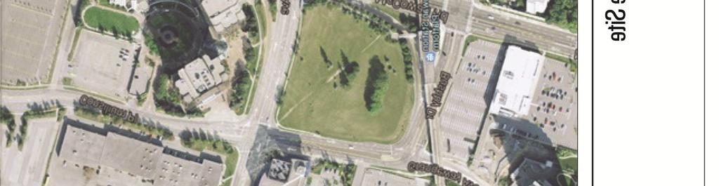
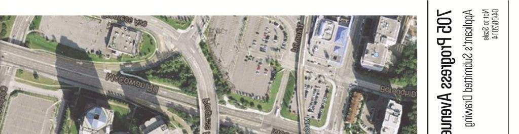
19 Attachment 8: 705 Progress Avenue Site Staff report for information Span McCowan & Market Building Proposal 19


20 Attachment 9: Highline Park, New York City, New York Staff report for information Span McCowan & Market Building Proposal 20
21 Attachment 10: Cost Estimates Glen Andrew Community Association's original proposal Glen Andrew Community Association's revised Deck Area (ha) Basic Structure Construction Basic Structure Maintenance (50 yrs) Ventilation Ventilation Equipment Maintenance (50 yrs) Total Deck Structure Cost Park Cost Total Deck + Park Cost 0.68 $20,400,000 $14,688,000 $23,800,000 $10,000,000 $68,888,000 $6,296,800 $75,184, $19,500,000 $14,040,000 $0 $0 $33,540,000 $6,019,000 $39,559,000 Staff report for information Span McCowan & Market Building Proposal 21
McCowan Precinct Plan Study Background & Deliverables
 1 DRAFT & WITHOUT PREJUDICE McCowan Precinct Plan Study Background & Deliverables In September, 2011, City Planning (Scarborough District) began a study of an area within the Scarborough Centre, identified
PILLAR FOUR INTEGRATE LAND USE & TRANSPORTATION
 PILLAR FOUR INTEGRATE LAND USE & TRANSPORTATION 8 Scarborough Centre on the Move Transportation Master Plan 123 8 Transportation Pillar Four Integrate Land Use & The fourth pillar focuses on the relationship
Welcome. Walk Around. Talk to Us. Write Down Your Comments
 Welcome This is an information meeting introducing the applications for proposed redevelopment of the Yorkdale Shopping Centre site at 3401 Dufferin Street and 1 Yorkdale Road over the next 20+ years,
SCARBOROUGH SUBWAY EXTENSION. Scarborough Subway Extension. Final Terms of Reference
 Scarborough Subway Extension Final Terms of Reference 1 1.0 Introduction and Background 1.1 Introduction Toronto City Council recently confirmed support for an extension of the Bloor-Danforth Subway from
4121 Lawrence Avenue East Rezoning Application Preliminary Report
 STAFF REPORT ACTION REQUIRED 4121 Lawrence Avenue East Rezoning Application Preliminary Report Date: October 11, 2011 To: From: Wards: Reference Number: Scarborough Community Council Director, Community
McCowan Precinct Plan Study Final Report
 STAFF REPORT ACTION REQUIRED McCowan Precinct Plan Study Final Report Date: May 2, 2014 To: From: Wards: Reference Number: Scarborough Community Council Director, Community Planning, Scarborough District
Bloor St. W. Rezoning - Preliminary Report
 STAFF REPORT ACTION REQUIRED 1638-1644 Bloor St. W. Rezoning - Preliminary Report Date: April 1, 2008 To: From: Wards: Reference Number: Toronto and East York Community Council Acting Director, Community
Relief Line Project Assessment
 Relief Line Project Assessment Public Information Centre April 5, 2017 Tonight s Meeting PURPOSE To review the preferred alignment for the Local Segment. AGENDA 6:30 Open House 7:00 Presentation / Discussion
South of Eastern Strategic Direction Status Update
 STAFF REPORT ACTION REQUIRED South of Eastern Strategic Direction Status Update Date: July 10, 2014 To: From: Planning and Growth Management Committee Chief Planner and Executive Director, City Planning
2900 Steeles Avenue East at Don Mills Road in the Town of Markham
 STAFF REPORT INFORMATION ONLY 2900 Steeles Avenue East at Don Mills Road in the Town of Markham Date: January 23, 2008 To: From: Wards: Reference Number: North York Community Council Director, Community
13 THORNHILL YONGE STREET STUDY IMPLEMENTATION CITY OF VAUGHAN OPA 669 AND TOWN OF MARKHAM OPA 154
 13 THORNHILL YONGE STREET STUDY IMPLEMENTATION CITY OF VAUGHAN OPA 669 AND TOWN OF MARKHAM OPA 154 The Planning and Economic Development Committee recommends the adoption of the recommendations contained
3 MARKHAM NORTH-SOUTH LINK CORRIDOR PUBLIC TRANSIT IMPROVEMENTS ENVIRONMENTAL ASSESSMENT UPDATE
 3 MARKHAM NORTH-SOUTH LINK CORRIDOR PUBLIC TRANSIT IMPROVEMENTS ENVIRONMENTAL ASSESSMENT UPDATE The Rapid Transit Public/Private Partnership Steering Committee recommends the adoption of the recommendations
Coordinated Transit Planning in Toronto SmartTrack GO RER Scarborough Relief Line Waterfront Transit
 Coordinated Transit Planning in Toronto SmartTrack GO RER Scarborough Relief Line Waterfront Transit Public Information Centres February 2016 Transportation Planning Section City Planning Division Toronto
THAT the attached Terms of Reference for the Thornhill Centre Street Study be approved.
 COMMITTEE OF THE WHOLE AUGUST 18, 2003 THORNHILL CENTRE STREET STUDY PLANNING FILE: 15.92 Recommendation The Commissioner of Planning recommends: THAT the attached Terms of Reference for the Thornhill
1.0 Purpose of a Secondary Plan for the Masonville Transit Village
 Report to Planning and Environment Committee To: Chair and Members Planning & Environment Committee From: John M. Fleming Managing Director, Planning and City Planner Subject: Masonville Transit Village
Official Plan Amendment for Scarborough Rapid Transit (SRT) Extension Final Report
 Extension Final Report") STAFF REPORT ACTION REQUIRED Official Plan Amendment for Scarborough Rapid Transit (SRT) Extension Final Report Date: April 27, 2010 To: From: Wards: Reference Number: Planning and Growth Management Committee
STAFF REPORT ACTION REQUIRED Official Plan Amendment for Scarborough Rapid Transit (SRT) Extension Final Report Date: April 27, 2010 To: From: Wards: Reference Number: Planning and Growth Management Committee
Planning and Growth Management Committee. Chief Planner and Executive Director, City Planning Division. Pg12013 (File No NNY 34 OZ)
") 865 York Mills Road Official Plan Amendment Application Preliminary Report STAFF REPORT ACTION REQUIRED Date: February 28, 2012 To: From: Wards: Reference Number: Planning and Growth Management Committee
865 York Mills Road Official Plan Amendment Application Preliminary Report STAFF REPORT ACTION REQUIRED Date: February 28, 2012 To: From: Wards: Reference Number: Planning and Growth Management Committee
LAND USE AMENDMENT DOWNTOWN COMMERCIAL CORE (WARD 7) MACLEOD TRAIL SE AND 5 AVENUE SE BYLAW 254D2017
 MACLEOD TRAIL SE AND 5 AVENUE SE BYLAW 254D2017") Page 1 of 10 EXECUTIVE SUMMARY This Land Use Amendment application seeks to redesignate a full downtown block (currently the YWCA site) from a Direct Control based on the CM-2 District (Land Use Bylaw
Page 1 of 10 EXECUTIVE SUMMARY This Land Use Amendment application seeks to redesignate a full downtown block (currently the YWCA site) from a Direct Control based on the CM-2 District (Land Use Bylaw
ELMVALE ACRES SHOPPING CENTRE MASTER PLAN
 ELMVALE ACRES SHOPPING CENTRE MASTER PLAN Contents 1.0 INTRODUCTION... 2 2.0 LOCATION... 2 3.0 EXISTING CONTEXT... 2 4.0 VISION & GUIDING PRINCIPLES... 2 5.0 LAND USE AND BUILT FORM... 4 5.1 St. Laurent
Land Use Amendment in Southwood (Ward 11) at and Elbow Drive SW, LOC
 at and Elbow Drive SW, LOC") 2018 November 15 Page 1 of 10 EXECUTIVE SUMMARY This land use amendment application was submitted by Rick Balbi Architect on 2017 August 31 on behalf of Sable Developments Ltd, and with authorization from
2018 November 15 Page 1 of 10 EXECUTIVE SUMMARY This land use amendment application was submitted by Rick Balbi Architect on 2017 August 31 on behalf of Sable Developments Ltd, and with authorization from
PART 1. Background to the Study. Avenue Study. The Danforth
 The Danforth 1.1/ Study Purpose & Key Municipal Goals 1.2/ The Local Advisory Committee 1.3/ The Project Team 1.4/ Study Process/Summary of Method 1.5/ Summary of Consultation 1.1 Study Purpose and Key
Clairtrell Area Context Plan
 Clairtrell Area Context Plan March 2005 Urban Development Services City Planning Contents 1. Introduction... 4 2. Development Structure... 6 2.1 Streets... 7 2.1.1 Sheppard Avenue and Bayview Avenue...
Director, Community Planning, Toronto and East York District
 Lower Yonge Precinct Plan Update STAFF REPORT ACTION REQUIRED Date: October 16, 2012 To: From: Wards: Reference Number: Toronto and East York Community Council Director, Community Planning, Toronto and
Welcome. Community Consultation Meeting November 28, Review and discuss the Bathurst Quay Neighbourhood Plan Framework
 Welcome Community Consultation Meeting November 28, 2016 Why Are We Here Today? Review and discuss the Bathurst Quay Neighbourhood Plan Framework Review and discuss an Action Plan for Implementation Next
CITY CLERK. Parkland Acquisition Strategic Directions Report (All Wards)
") CITY CLERK Clause embodied in Report No. 10 of the, as adopted by the Council of the City of Toronto at its meeting held on November 6, 7 and 8, 2001. 10 Parkland Acquisition Strategic Directions Report
CITY CLERK Clause embodied in Report No. 10 of the, as adopted by the Council of the City of Toronto at its meeting held on November 6, 7 and 8, 2001. 10 Parkland Acquisition Strategic Directions Report
STAFF REPORT. December 20, North York Community Council. Director, Community Planning, North York District
 STAFF REPORT December 20, 2005 To: From: Subject: North York Community Council Director, Community Planning, North York District Preliminary Report Application to Amend the Official Plan and Zoning By-law
Emery Village Road 2A Municipal Class Environmental Assessment Study
 PW12.11 STAFF REPORT ACTION REQUIRED Emery Village Road 2A Municipal Class Environmental Assessment Study Date: March 30, 2016 To: From: Wards: Reference Number: Public Works and Infrastructure Committee
1296 Kennedy Road - Zoning Amendment Application - Preliminary Report
 STAFF REPORT ACTION REQUIRED 1296 Kennedy Road - Zoning Amendment Application - Preliminary Report Date: January 15, 2016 To: From: Wards: Reference Number: Scarborough Community Council Acting Director,
5 TOWN OF MARKHAM OFFICIAL PLAN AMENDMENT NO. 144 MILLIKEN MAIN STREET SECONDARY PLAN
 5 TOWN OF MARKHAM OFFICIAL PLAN AMENDMENT NO. 144 MILLIKEN MAIN STREET SECONDARY PLAN The Planning and Economic Development Committee recommends the following: 1. The communication from Brendan O Callaghan,
TOWN OF WHITBY REPORT RECOMMENDATION REPORT
 TOWN OF WHITBY REPORT RECOMMENDATION REPORT REPORT TO: Council REPORT NO: PL 95-09 DATE OF MEETING: October 13, 2009 PREPARED BY: Planning/Public Works Joint Report FILE NO(S): N/A LOCATION: N/A REPORT
Queen Street West - Zoning Amendment Application - Preliminary Report
 STAFF REPORT ACTION REQUIRED 944-952 Queen Street West - Zoning Amendment Application - Preliminary Report Date: February 6, 2013 To: From: Wards: Reference Number: Toronto and East York Community Council
The transportation system in a community is an
 7 TRANSPORTATION The transportation system in a community is an important factor contributing to the quality of life of the residents. Without a sound transportation system to bring both goods and patrons
Tippett Road Area Regeneration Study Final Report. Planning and Growth Management Committee
 PG8.6 STAFF REPORT ACTION REQUIRED Tippett Road Area Regeneration Study Final Report Date: October 23, 2015 To: From: Wards: Reference Number: Planning and Growth Management Committee Chief Planner and
John M. Fleming Managing Director, Planning and City Planner. Old East Village Dundas Street Corridor Secondary Plan Draft Terms of Reference
 Report to Planning and Environment Committee To: From: Subject: Chair and Members Planning & Environment Committee John M. Fleming Managing Director, Planning and City Planner Old East Village Dundas Street
Don Mills Crossing Study and Celestica Lands Development Application Community Meeting, Open House, and Breakout Discussions
 Consultation Summary Don Mills Crossing Study and Celestica Lands Development Application Community Meeting, Open House, and Breakout Discussions This report is not intended to provide a verbatim transcript
Johnson Street Bridge Public Realm Update
 Johnson Street Bridge Public Realm Update August 20, 2015 Background Johnson Street Bridge Replacement Project impacts a diverse range of stakeholders In addition to a new bridge, the project also includes
1071 King Street West Zoning Amendment Application - Preliminary Report
 STAFF REPORT ACTION REQUIRED 1071 King Street West Zoning Amendment Application - Preliminary Report Date: August 9, 2012 To: From: Wards: Reference Number: Toronto and East York Community Council Director,
599 Kennedy Road - Official Plan Amendment and Zoning Amendment Application - Preliminary Report
 STAFF REPORT ACTION REQUIRED 599 Kennedy Road - Official Plan Amendment and Zoning Amendment Application - Preliminary Report Date: March 7, 2017 To: From: Wards: Reference Number: Scarborough Community
CITY OF VAUGHAN EXTRACT FROM COUNCIL MEETING MINUTES OF NOVEMBER 15, 2016
 Item 11, Report No. 38, of the Committee of the Whole, which was adopted without amendment by the Council of the City of Vaughan on November 15, 2016. Regional Councillor Di Biase declared an interest
From: Director, Community Planning, Scarborough District. Ward 40 Scarborough-Agincourt
 STAFF REPORT ACTION REQUIRED 2967 Sheppard Ave E - Zoning Amendment Application - Preliminary Report Date: July 18, 2014 To: Scarborough Community Council From: Director, Community Planning, Scarborough
AGINCOURT SECONDARY PLAN
 1 AGINCOURT SECONDARY PLAN 1. AGINCOURT SECONDARY PLAN The following policies and principles apply to the area herein referred to as Agincourt, as outlined on Map 1-1. 1. GENERAL POLICIES 1.1 This Secondary
SUBJECT: GO Station Mobility Hubs Preferred Concepts: Aldershot GO, Burlington GO and Appleby GO. Planning and Development Committee - Public Meeting
 Page 1 of Report PB-76-17 SUBJECT: GO Station Mobility Hubs Preferred Concepts: Aldershot GO, Burlington GO and Appleby GO TO: FROM: Planning and Development Committee - Public Meeting Planning and Building
Preserving Green Streetscape Character on Hillside Drive
 STAFF REPORT ACTION REQUIRED Preserving Green Streetscape Character on Hillside Drive Date: February 19, 2014 To: From: Toronto and East York Community Council Deputy City Manager, Cluster B Wards: Toronto-Danforth,
Committee of the Whole Report
 Item: Committee of the Whole Report DATE: Monday, September 17, 2018 WARD: 4 TITLE: ZONING BY-LAW AMENDMENT FILE Z.17.036 SITE DEVELOPMENT FILE DA.17.083 IVANHOE CAMBRIDGE VICINITY OF JANE STREET AND RUTHERFORD
Pedestrian and Bike Bridge LOGO
 6.2.2 Pedestrian and Bike Bridge The proposed pedestrian and bike crossing re-envisions the existing bridge at Pismo Creek on Cypress Street. The bridge is currently underutilized by vehicular through
City of Farmington. Downtown Plan. Amendment to the 1998 Master Plan Adopted October 11, 2004
 City of Farmington Amendment to the 1998 Master Plan Adopted October 11, 2004 Introduction Planning Background 1 Scope and Components of the Plan Amendment 2 Concept Introduction 3 Plan Concepts 3 Conceptual
Eglinton Avenue East & 50 Thermos Road - Official Plan Amendment Application Preliminary Report
 STAFF REPORT ACTION REQUIRED 1966 2050 Eglinton Avenue East & 50 Thermos Road - Official Plan Amendment Application Preliminary Report Date: March 15, 2016 To: From: Wards: Reference Number: Scarborough
MAYFIELD WEST SECONDARY PLAN PHASE 2
 MAYFIELD WEST SECONDARY PLAN PHASE 2 Public Open House #3 February 25, 2010 Draft Preferred Land Use Scenario TOWN OF CALEDON PLANNING & DEVELOPMENT DEPARTMENT Open House Agenda TOWN OF CALEDON 1. Welcome
Chapter 1: Introduction
 Chapter 1: Introduction The Penn Avenue Community Works Corridor Vision and Implementation Framework presents an integrated communitybased vision and a coordinated, long-term implementation framework for
8 Oak Street - Official Plan and Zoning By-law Amendment Application - Preliminary Report
 STAFF REPORT ACTION REQUIRED 8 Oak Street - Official Plan and Zoning By-law Amendment Application - Preliminary Report Date: March 17, 2014 To: From: Wards: Reference Number: Planning and Growth Management
Scarborough Centre Transportation Master Plan Final Report
 REPORT FOR ACTION Scarborough Centre Transportation Master Plan Final Report Date: April 11, 2018 To: Scarborough Community Council From: Director Transit and Transportation Planning and Director Community
Town Center (part of the Comprehensive Plan)
") Town Center (part of the Comprehensive Plan) Mercer Island Town Center Looking North (2014) In 1994, a year-long process culminated in a set of design guidelines and code requirements for the Town Center
Town Center (part of the Comprehensive Plan) Mercer Island Town Center Looking North (2014) In 1994, a year-long process culminated in a set of design guidelines and code requirements for the Town Center
Public Open House. YWCA, 87 Elm Street December 2nd, 2017, 10 a.m. 2 p.m.
 Public Open House YWCA, 87 Elm Street December 2nd, 2017, 10 a.m. 2 p.m. 1 A 25-Year Downtown Plan A blueprint for future growth and infrastructure in the heart of Toronto Ensuring growth contributes positively
240 and 242 Finch Avenue West Zoning By-law Amendment Application Preliminary Report
 REPORT FOR ACTION 240 and 242 Finch Avenue West Zoning By-law Amendment Application Preliminary Report Date: March 1, 2019 To: North York Community Council From: Director, Community Planning, North York
The West Vaughan Employment Area Secondary Plan Policies
 Part 2: The West Vaughan Employment Area Secondary Plan Policies 2.1 General Policies It is the policy of Council: 2.1.1. That the West Vaughan Employment Area (the WVEA), identified on Schedule 1, will
YONGE STEELES CORRIDOR SECONDARY PLAN. Young + Wright / IBI Group Architects Dillon Consulting Ltd. GHK International (Canada) Ltd.
 Ltd.") PART A: PREAMBLE 1.0 PURPOSE The purpose of this Secondary Plan is to provide a development framework for intensification of the Yonge/ Steeles corridor including the north side of Steeles Avenue West
PART A: PREAMBLE 1.0 PURPOSE The purpose of this Secondary Plan is to provide a development framework for intensification of the Yonge/ Steeles corridor including the north side of Steeles Avenue West
3. Endorse the LRT vision in transforming Surrey into Connected-Complete-Livable communities, and more specifically, the official vision statement:
 CORPORATE REPORT NO: R038 COUNCIL DATE: February 20, 2017 REGULAR COUNCIL TO: Mayor & Council DATE: February 16, 2017 FROM: General Manager, Engineering FILE: 8740-01 SUBJECT: Surrey Light Rail Transit
9 CITY OF VAUGHAN OFFICIAL PLAN AMENDMENT NO BOCA EAST INVESTMENTS LIMITED
 9 CITY OF VAUGHAN OFFICIAL PLAN AMENDMENT NO. 631 - BOCA EAST INVESTMENTS LIMITED The Planning and Economic Development Committee recommends the adoption of the recommendations contained in the following
Northeast Corner of Steeles Avenue West and Jane Street, City of Vaughan
 STAFF REPORT ACTION REQUIRED Northeast Corner of Steeles Avenue West and Jane Street, City of Vaughan Date: June 1, 2010 To: From: Wards: Reference Number: North York Community Council Director, Community
FORMER CANADIAN FORCES BASE (CFB) ROCKCLIFFE SECONDARY PLAN. Official Plan Amendment XX to the Official Plan for the City of Ottawa
 ROCKCLIFFE SECONDARY PLAN. Official Plan Amendment XX to the Official Plan for the City of Ottawa") FORMER CANADIAN FORCES BASE (CFB) ROCKCLIFFE SECONDARY PLAN Official Plan Amendment XX to the Official Plan for the City of Ottawa 1 INDEX THE STATEMENT OF COMPONENTS PART A THE PREAMBLE PAGE Purpose...
FORMER CANADIAN FORCES BASE (CFB) ROCKCLIFFE SECONDARY PLAN Official Plan Amendment XX to the Official Plan for the City of Ottawa 1 INDEX THE STATEMENT OF COMPONENTS PART A THE PREAMBLE PAGE Purpose...
St. Lawrence Neighbourhood Focused Area - Official Plan Amendment Status Report
 STAFF REPORT ACTION REQUIRED St. Lawrence Neighbourhood Focused Area - Official Plan Amendment Status Report Date: May 21, 2015 To: From: Wards: Reference Number: Toronto and East York Community Council
South Yonge Street Corridor
 South Yonge Street Corridor Streetscape Master Plan Study Draft Final Executive Summary Prepared by: January 2012 In Partnership with: Introduction The Future... Yonge Street is at the forefront of York
WELCOME TO OPEN HOUSE TWO November 28, 2018
 Langstaff Road Weston Road to Highway 7 Class Environmental Assessment Study WELCOME TO OPEN HOUSE TWO November 28, 2018 Please sign in and join our mailing list Study Overview York Region is conducting
St. Clair Avenue West Area Transportation Master Plan
 1 (Between Keele Street and Old Weston Road) Public Information Centre 1 December 2, 2015 2 Welcome Welcome to the first Public Information Centre for the St. Clair Avenue West Area. The panels will present
523, 525 and 525A Adelaide Street West - Zoning Amendment Application - Preliminary Report
 STAFF REPORT ACTION REQUIRED 523, 525 and 525A Adelaide Street West - Zoning Amendment Application - Preliminary Report Date: May 12, 2012 To: From: Wards: Reference Number: Toronto and East York Community
City of Toronto. Emery Village Transportation Master Plan
 City of Toronto Emery Village Transportation Master Plan May 2009 Emery Village Transportation Master Plan Toronto, ON May 2009 Consulting Inc. 100 York Blvd., Suite 300 Richmond Hill, ON L4B 1J8 Tel:
hermitage town center
 hermitage town center A Community Vision prepared by Strada for The City of Hermitage and The Mercer County Regional Planning Commission January 2007 table of contents introduction 3 design principles
Finch Avenue West and Sheppard Avenue East Corridors - Planning Study Approach. Planning and Growth Management Committee
 PG8.9 STAFF REPORT ACTION REQUIRED Finch Avenue West and Sheppard Avenue East Corridors - Planning Study Approach Date: October 13, 2015 To: From: Planning and Growth Management Committee Chief Planner
appendix and street interface guidelines
 appendix five: building and street interface guidelines appendix 5 building and street interface guidelines BOULEVARDS Boulevards are generally characterized by higher levels of traffic movement at higher
THE GARDEN CITY PLAN. City of St. Catharines Official Plan. City of St. Catharines
 THE GARDEN CITY PLAN City of St. Catharines Official Plan City of St. Catharines August 2010 APPROVAL INFORMATION This Official Plan of the City of St. Catharines Planning Area, known as the Garden City
Report to: Development Services Committee Report Date: September 11, 2017
 ~RKHAM Report to: Development Services Committee Report Date: September 11, 2017 SUBJECT: PREPARED BY: Conceptual Master Plan for the Future Urban Area - Community Structure Plan and Key Policy Direction
Agincourt Mall Planning Framework Review Status Report
 STAFF REPORT ACTION REQUIRED Agincourt Mall Planning Framework Review Status Report Date: May 16, 2018 To: From: Scarborough Community Council Director, Community Planning, Scarborough District Wards:
UTSC SECONDARY PLAN COMMUNITY OPEN HOUSE
 WELCOME TO THE UTSC SECONDARY PLAN COMMUNITY OPEN HOUSE 1 Welcome to the first Community Open House for the UTSC Secondary Plan. Hosted by the University of Toronto Scarborough (UTSC), the following panels
Services Department F May 28, 2007
 Report To: Development Services Committee Item: Date of Report: From: DS-07-144 May 23, 2007 Commissioner, Development File: Date of Meeting: Services Department F-7000-0013 May 28, 2007 Subject: Gibb
PINE CURVE REZONING. Property does not meet criteria for open space preservation and is not a candidate for a park
 PINE CURVE REZONING BACKGROUND Purchased as two parcels in 2001 and 2002 Annexed and Zoned Greater Downtown District Historic Center September 25, 2002 and October 7, 2002 WHAT THE PROJECT IS AND IS NOT
King-Spadina Secondary Plan Community Consultation Meeting. Michelle Knieriem, City Planner October 11, 2017
 King-Spadina Secondary Plan Community Consultation Meeting Michelle Knieriem, City Planner October 11, 2017 Agenda 6:30 Welcome 6:35 Presentation 7:15 Question and Answer Session 8:15 Closing Remarks HOW
Downtown Streetscape Manual & Built Form Standards
 City of Guelph Downtown Streetscape Manual & Built Form Standards July 2014 Prepared by Brook McIlroy Inc. in association with Unterman McPhail Associates and McCormick Rankin Inc. City of Guelph Downtown
Humber Bay Shores Precinct Plan Final Report
 STAFF REPORT ACTION REQUIRED Humber Bay Shores Precinct Plan Final Report Date: May 21, 2010 To: From: Wards: Reference Number: Etobicoke York Community Council Director, Community Planning, Etobicoke
The Village of Shirlington
 The Village of Shirlington Suburban Smart Growth Without Rail Transit July 2018 Agenda History (1940 to present) Attributes and Outcomes Lessons Learned Setting the Stage Arlington County Arlington is
4780 Eglinton Avenue West - Zoning By-law Amendment and Draft Plan of Subdivision Applications - Preliminary Report
 STAFF REPORT ACTION REQUIRED 4780 Eglinton Avenue West - Zoning By-law Amendment and Draft Plan of Subdivision Applications - Preliminary Report Date: May 29, 2014 To: From: Wards: Reference Number: Etobicoke
GLEN ROAD PEDESTRIAN BRIDGE ENVIRONMENTAL ASSESSMENT STUDY PUBLIC INFORMATION CENTRE #2 OCTOBER 24, 2017
 GLEN ROAD PEDESTRIAN BRIDGE ENVIRONMENTAL ASSESSMENT STUDY PUBLIC INFORMATION CENTRE #2 OCTOBER 24, 2017 Glen Road Pedestrian Bridge Class Environmental Assessment 1 WELCOME! Welcome to the second Public
Public input has been an important part of the plan development process.
 Lakewood s Comprehensive Plan recognizes that transportation helps shape the community, and that the way the community provides for the safe and efficient movement of people affects the character of the
QUEEN-RIVER SECONDARY PLAN
 34 QUEEN-RIVER SECONDARY PLAN 34. QUEEN RIVER SECONDARY PLAN 1. INTRODUCTION The Queen-River area is approximately 6.4 hectares and is located at the eastern edge of the Downtown as shown on Map 34-1.
8 & 10 Donalda Crescent Official Plan & Rezoning Application Final Report
 STAFF REPORT ACTION REQUIRED 8 & 10 Donalda Crescent Official Plan & Rezoning Application Final Report Date: July 26, 2010 To: From: Wards: Reference Number: Scarborough Community Council Director, Community
ARLINGTON COUNTY, VIRGINIA
 ARLINGTON COUNTY, VIRGINIA County Board Agenda Item Meeting October 15, 2005 DATE: September 28, 2005 SUBJECT: Request to Advertise the adoption of the 2005 Clarendon Sector Plan C. M. RECOMMENDATION:
646 Kingston Road - Official Plan Amendment and Zoning Amendment Applications - Preliminary Report
 STAFF REPORT ACTION REQUIRED 646 Kingston Road - Official Plan Amendment and Zoning Amendment Applications - Preliminary Report Date: December 8, 2014 To: From: Wards: Reference Number: Toronto and East
Public Open House. Overview of the Downtown Plan Official Plan Amendment April 23, 2018
 Public Open House Overview of the Downtown Plan Official Plan Amendment April 23, 2018 1 A 25-Year Plan for Downtown To ensure growth contributes positively to Toronto s Downtown as a great place to live,
DRAFT PLAN PRESENTATION
 DRAFT PLAN PRESENTATION 1.23.2018 AGENDA Process Project Schedule Results from Visioning Workshop Draft Plan Highlights Concept Plans Feedback Next Steps PROJECT SCHEDULE KICK-OFF WORKSHOP August 29 th
30 and 44 Zorra Street - Zoning By-law Amendment Application - Preliminary Report
 STAFF REPORT ACTION REQUIRED 30 and 44 Zorra Street - Zoning By-law Amendment Application - Preliminary Report Date: March 14, 2016 To: From: Wards: Reference Number: Etobicoke York Community Council Director,
Workshop 3. City of Burlington Waterfront Hotel Planning Study. September 14, The Planning Partnership
 Workshop 3 City of Burlington Waterfront Hotel Planning Study September 14, 2017 The Planning Partnership The Waterfront Hotel Planning Study 01 The Brant & Lakeshore Planning Study will establish a Strategic
Grafton Street < N September 2, 2015
 Grafton Street < N September 2, 2015 Project Background, Site Inventory + Analysis Brunswick Street Duke Street Scotia Bank Centre Carmichael Street Argyle Street City Hall Grand Parade Barrington Street
393, 395, 397, 399, 401 and 403 Spring Garden Avenue Official Plan and Zoning By-law Amendment Application Preliminary Report
 STAFF REPORT ACTION REQUIRED 393, 395, 397, 399, 401 and 403 Spring Garden Avenue Official Plan and Zoning By-law Amendment Application Preliminary Report Date: March 29, 2010 To: From: Wards: Reference
Courtice Main Street Study Community Vision Workshop PLANNING SERVICES DEPARTMENT
 Courtice Main Street Study Community Vision Workshop PLANNING SERVICES DEPARTMENT July 22, 2009 Tonight s Meeting 7:00 pm Introduction David Crome, Director of Planning 7:05 Presentation Stasia Bogdan,
Stanley Greene District Downsview (80 Carl Hall Road) Zoning By-law Amendment and Draft Plan of Subdivision Applications Request for Direction Report
 Zoning By-law Amendment and Draft Plan of Subdivision Applications Request for Direction Report") STAFF REPORT ACTION REQUIRED Stanley Greene District Downsview (80 Carl Hall Road) Zoning By-law Amendment and Draft Plan of Subdivision Applications Request for Direction Report Date: December 16, 2011
STAFF REPORT ACTION REQUIRED Stanley Greene District Downsview (80 Carl Hall Road) Zoning By-law Amendment and Draft Plan of Subdivision Applications Request for Direction Report Date: December 16, 2011
38 Queen s University Campus Master Plan Part 1
 38 Queen s University Campus Master Plan Part 1 46 The Campus at the City Scale Chapter 4 The Campus at the City Scale 39 Queen s is an urban University centrally located in Kingston. Decisions made by
REPORT TO: Council FOR: Regular Meeting. PRESENTED: April 1, 2008 FILE: , Byl 1932 & 1936
 DISTRICT OF SQUAMISH REPORT TO: Council FOR: Regular Meeting PRESENTED: April 1, 2008 FILE: 2006-08, Byl 1932 & 1936 DEPARTMENT: Planning Department SUBJECT: First and Second Readings for Bylaws 1932 (rezoning)
MAIN STREET ECONOMIC DEVELOPMENT STRATEGY
 MAIN STREET ECONOMIC DEVELOPMENT STRATEGY A PATHWAY TO A BETTER POUGHKEEPSIE DRAFT Working Paper #2: Planning Strategies Submitted December 1 st, 2015 to the City of Poughkeepsie LAND USE LAW CENTER PACE
RAILWAY LANDS EAST SECONDARY PLAN
 17 RAILWAY LANDS EAST SECONDARY PLAN 17. RAILWAY LANDS EAST SECONDARY PLAN 1. INTERPRETATION 1.1 The lands affected by the Railway Lands East Secondary Plan are shown on Map 17-1. 1.2 The boundaries of
Mark-up of the effect of the proposed Bronte Village Growth Area OPA No.18 on the text of section 24, Bronte Village, of the Livable Oakville Plan
 Mark-up of the effect of the proposed Bronte Village Growth Area OPA No.18 on the text of section 24, Bronte Village, of the Livable Oakville Plan Notes: This document is provided for information purposes
PINE CURVE REZONING. BACKGROUND Purchased as two parcels in 2001 and 2002
 BACKGROUND Purchased as two parcels in 2001 and 2002 WHAT THE PROJECT IS AND IS NOT A Rezoning establishes the land use standards for Annexed and Zoned Greater Downtown District Historic Center September