Balboa Park Master Plan Plan Amendments
|
|
|
- John Freeman
- 6 years ago
- Views:
Transcription

1 Balboa Park Master Plan Plan Amendments
2 BALBOA PARK MASTER PLAN AND CENTRAL MESA PRECISE PLAN PURPOSE OF THE PARK BOULEVARD PROMENADE AMENDMENTS The overall purposes of the amendments are: To increase the amount of space for the San Diego Zoo for conservation oriented, bioclimatic exhibits to facilitate the conservation, education, and research activities needed to save endangered and threatened species To improve the ease of visitor access to the North Prado, both now and given future growth, To strengthen the connection between the Zoo entry and other North Prado institutions. These purposes are achieved by the following major physical changes enabled by these plan amendments: 1. Asphalt parking lots near Spanish Village and Natural History Museum are converted to a public promenade between the new Zoo entry and the Prado. 2. Zoo Parking lot is converted to Zoological Gardens, parking for the War Memorial Building, and a greenbelt that includes the miniature train and public open space. 3. The Zoo entry is reoriented toward the South, creating a stronger connection to the Prado and the rest of Balboa Park. 4. A 4803-space below-ground public parking structure is located in the North Prado, along Park Boulevard. 5. A new Transit Center with an integral new pedestrian bridge is located in the North Prado. 6. A new below ground transportation center near the Natural History Museum and a new Zoo secondary group entrance near the War Memorial are created to help manage group access to the North Prado. 7. Pedestrian and auto conflict are eliminated in the North Prado. These plan amendments raise two notable policy issues: (1) the increase in Zoological Garden space and (2) the increase in parking in Central Mesa. Zoological Garden Expansion The current Central Mesa Precise Plan calls for the Zoo parking lot to remain a parking lot with improved landscaping. The plan amendments convert this parking lot to Zoological Gardens, greenbelt, Zoo group entry and parking adjacent to the War Memorial. The Zoo parking lot is part of the Zoological Society s leasehold. The lease expires in As a result, any change in use prior to that time requires the agreement of both the Zoological Society and the City of San Diego. Over time zoos have changed from menageries of animals in cages to concrete and moated exhibits, and finally the latest transition -- conservation-oriented, bioclimatic habitats. Today s conservationoriented zoos require more space. i
3 The modern Zoo facilitates conservation and research activities needed to save endangered and threatened species. - Researchers and animal care specialists learn about animal reproduction, diet and social behavior contributing to saving species in the wild. - Visitors are educated about the natural history and geography of animals as well as the plight of endangered species related to habitat loss and encroachment resulting from human activities. - Animal reproduction contributes to genetic diversity and self-sustaining populations of species while increasing opportunities to reintroduce species to remaining safe habitats in the wild. In 1984 the Zoological Society of San Diego adopted a long-range Bioclimatic Plan to guide the redevelopment of the Zoo. The goal was to create self-sustaining populations of threatened and endangered species and to enhance scientific research, conservation and education opportunities. The plan addressed animal behavior as it relates to both environmental considerations (such as the bioclimatic zones) and their complex social order. In 1995 the planning and architectural staff of the Zoological Society realized the 1984 Bioclimatic Plan underestimated the space needed for redeveloping the Zoo s animal/botanical exhibits and related support areas. From concept to development, naturalistic exhibits were requiring substantially more space than anticipated. Also environmental rules and Americans with Disabilities Act requirements reduce the amount of usable acreage within the Zoo s current fence line. In response to this shortfall of space, the Zoological Society S S S S S Continued pursuing methods of using the current leasehold more efficiently through redevelopment of old exhibit areas. Explored additional opportunities to use the Wild Animal Park, considering the climate and other limiting factors. Focused on exhibits for species that need the coastal climate of Balboa Park. Downscaled some of the exhibit plans. Worked with the City s Working Group to explore possibility of use of Zoo parking lot for Zoological gardens. These plan amendments implement the last of these actions related to the shortfall of space. The other on-going efforts listed above are on an independent track. In December 2000 the final report of the city s Working Group for the Proposed Balboa Park Master and Precise Plan Amendments and the Zoological Society of San Diego Leasehold was published. This report included a discussion of options relating to Zoo expansion, parking, ideas for increasing open green and natural spaces as well as other Balboa Park issues. All design teams taking part in the design charrette, with the exception of one, proposed that the San Diego Zoological Society be allowed to expand Zoo facilities within the parking lot area. A majority of the design options detailed a mix of Zoo use with parking and open green space. Benefits attributed to Zoo use of the parking lot were the elimination of unattractive surface parking lot and elimination of urban run off. Concerns related to Zoo use of the parking lot were the loss of parking spaces. However, the issue of restricting and intensifying land use was perceived as both a positive and negative. The positive being the value of improvements to the San Diego Zoo and its conservation and ii
4 education mission. The negative being privatization, that is the placement of the area inside the Zoo s fence line. Related to these observations on Zoo parking lot use, the Working Group identified the advantages of having a green belt along Park Boulevard. This would provide a visual corridor and softer edge to the expanded development and enhance the linkages between the Park and the communities to the north and to offset privately controlled land uses (Zoo) moving out towards Park Boulevard. The only identified disadvantage related to the greenbelt was that uses may be limited due to size and adjacency to Park Boulevard. The Plan Amendments have been developed within the context of this direction from the City s Working Group. A defined visual green corridor with pedestrian linkages and public open space are included. In addition the miniature train has been relocated within the greenbelt, adding both visual interest and an activity dynamic to the area. The greenbelt width ranges from 87 feet to 233 feet wide. This contrasts with the current planting strip of approximately 15 feet wide. Parking The currently adopted Central Mesa Precise Plan (p. 195) specifically calls for increased parking in Central Mesa. However, the current plan recommendations show only 165 to 665 additional parking spaces to serve future visitor demand in the Central Mesa. This modest increase is accomplished (in the current plan) by a new parking structure behind the Organ Pavilion. In furtherance of the current plan objective to increase public parking in the Central Mesa, these Plan Amendments create a net increase of 2059 parking spaces in the North Prado. A total of 5352 spaces are created as follows: The 4803-space public parking structure, 99 public parking spaces adjacent to the War Memorial Building, and 450 new employee spaces within the Zoo fence line (employee spaces draw employees out of the public lots thereby freeing up visitor parking for visitors). A total of 3293 spaces are lost as follows: 2831 spaces in the Zoo lot, 103 spaces in the north Carousel lot, 215 spaces in the South Carousel lot, 101 spaces in the Natural History museum lot, 24 spaces on Park Boulevard and 19 spaces on Zoo Drive. In 2000, the Working Group was presented with the information in Table 1 regarding the supply and demand for parking in Balboa Park. iii
5 Institution/Use San Diego Zoo Table 1 Parking Demand and Supply Data Presented to Zoo Working Group in 2000 Other cultural institutions in Central Mesa General User of the Park (National Recreation and Park Association standard) Recreational users of city operated facilities (organ pavilion, puppet theater, hall rentals, House of Hospitality offices/restaurant etc) Parking Data Presented to Working Group in visitor spaces needed in 2020 Adequate 85% of all days - more parking required 55 days each year) 3216 visitor spaces needed in 2020 (Adequate 85% of all days - more parking required 55 days each year) Presenter of the information Zoological Society of San Diego Dr. Mick Hager on behalf of the Central Balboa Park Association 2538 visitor spaces Park and Recreation Department Staff No information presented for these users Naval Medical Center 5150 total spaces needed; 2000 space deficit in 2020 City College Captain Patricia Denzel of the Naval Medical Center 4000 total spaces needed in 2020 City College staff Existing Total Parking Spaces 6659 in July 2000 Data collected by Park Rangers iv
6 The major determinants of the size of the parking structure were: 1) The popularity of the North Prado as a destination. The North Prado includes many popular cultural institutions: the Zoo, Spanish Village, Natural History Museum, Rose Garden, Fleet Science Center, Prado complex, and Junior Theater. The Zoo by itself attracts 3.5 million visitors which is 50% of all the visitors to cultural institutions in the entire Central Mesa. Due to the area s popularity, the Zoo uses off-site parking areas 100 days per year to accommodate Zoo visitor parking demand. 2) Anticipated visitor growth. Zoo visitors are projected to increase from 3.5 million in 2000 to million in This 26% increase in visitors will bring a commensurate increase in parking demand. Assuming 20% of the visitors arrive by alternate modes such as transit, and there are 3.3 persons per car, the Zoo parking demand alone in 2020 would be 3900 spaces (employee and visitor) on a design day. A design day is a typically busy day and assumes off-site parking arrangements would be required at least 25 days a year. Dr. Mick Hager, Executive Director of the Natural History Museum, reported to the Working Group in September 2000 that the other cultural institutions throughout the Central Mesa collectively have visitor attendance equal to that of the Zoo and anticipate a similar growth trend. 3) Replacement of Eliminated Spaces At a minimum, the eliminated spaces (3293) need to be replaced, but this does not account for current parking deficits or future growth. 4) The physical and cultural constraints on the site. The Park Boulevard Promenade Parking Structure was designed to respect the existing historical area and the existing leaseholds. For this reason the parking structure foot print is contoured around Spanish Village and the Natural History Museum. As such, a 4-level below-ground public parking structure can accommodate a maximum of 4803 public parking spaces. Within the context of this information, the plan amendments include a 4803-space public parking structure for the following reasons: 1. Simply replacing the 3293 lost surface spaces is not sufficient because it does not account for current parking deficits or future growth demand. v
7 2. Sizing the parking structure to only handle the Zoo parking demand (in 2020) of 3900 spaces ignores the fact it is public parking serving all park visitors and since this public parking is first-come/first-serve, the mix of visitors going to the North Prado institutions on a design day would be seriously under-served. 3. Sizing the parking structure larger than 4803 public parking spaces is impractical because of the physical constraints of the site. For more background information on these and other planning issues, refer the Park Boulevard Promenade Draft Environmental Impact Report and the December 14, 2000 Final Report of the Working Group for the Proposed Balboa Park Master and Precise Plan Amendments and the Zoological Society of San Diego Leasehold. In conjunction with the approved 1989 Balboa Park Master Plan and the 1992 Central Mesa Precise Plan, these plan amendments give definition and guidance to the future development of the Central Mesa of Balboa Park. The Balboa Park Master Plan, Central Mesa Precise Plan and these amendments will contribute to cultural, educational, recreational and social life of the entire San Diego region. These amendments are organized in the same order as the approved Balboa Park Master Plan and Central Mesa Precise Plan. Those plan text and graphics which changed as a result of the inclusion of the Park Boulevard Promenade are revised and included. All text which has been revised or added from the originally approved plans is underlined. May 19, 2003 vi
8 TABLE OF CONTENTS INTRODUCTION PAGE Purpose of the Plan 1 The Vision 3 DESIGN PRINCIPLES 5 Goals, Objectives, and Design Principles 7 THE MASTER PLAN 13 Master Plan Summary 15 Conceptual Subarea Master Plans 21 - El Prado West 25 - El Prado East and Spanish Village 29 - The Palisades 33 - Inspiration Point 37 - Central Operations Station 45 - Zoo Parking Lot and Florida Canyon 49 - Morley Field and Arizona Landfill 53 - Golden Hill 57 MASTER PLAN ELEMENTS 61 Land Use, Architecture and Site Design 63 Access, Circulation and Parking 67 Historic Preservation 89 Safety & Security 95 Horticulture 97 Lighting 107 Signage 113
9 TABLE OF CONTENTS, CONTINUED MASTER PLAN IMPLEMENTATION 119 Precise Plans 121 Phasing and Construction Costs 123 Financing 129 MASTER PLAN ANALYSIS 155 Planning Context 157 Land Use and Architecture 167 Access, Circulation and Parking 181 Topography, Soils, Geology 191 Visual Analysis 199 Horticulture 203 Site Analysis Summary 211 HORTICULTURAL INVENTORY 215 CITY COUCIL RESOLUTIONS 239 BIBLIOGRAPHY 247
10 LIST OF FIGURES Figure Page 1 Illustrative Master Plan * 19 2 Key Map for Conceptual Subarea Master Plans * 23 3 Prado West 27 4 Prado East and Spanish Village * 31 5 The Pallisades 35 6 Inspiration Point North 39 7 Inspiration Point South 43 8 Central Operations Station 47 9 Zoo Parking Lot * Morley Field and Arizona Landfill Golden Hill Proposed Land Use and Vicinity Map * Proposed Circulation and Parking * Pedestrian Trail System * Bicycle Trail System * Proposed Alternative transportation System * 83 17A Historical Landmark Zone * 91 17B Historical Landmark Zone * Conceptual Landscape Plan * Exterior Lighting Concepts * Signage Concepts * Bartholomew Plan Location Map Existing Land Use and Vicinity Map Existing Balboa Park Plan Land Use Zones 171 * Figures revised in this draft amendment
11 LIST OF FIGURES, CONTD 26 Estimated Daily Attendance Existing Circulation and Parking Traffic Analysis Elevation Analysis Slope Analysis Visual Analysis Existing Horticultural Inventory (Massing) Summary Site Analysis Existing Horticultural Inventory (Grid) 215 LIST OF TABLES Table Page 1 Balbao Park Nighttime Parking Supply and 188 Occupancy * Figures revised in this draft amendment

12
13 THE HOUSE OF PACIFIC RELATIONS Expand the House of Pacific Relations area by 4,000 square feet including additional landscaping. THE SPANISH VILLAGE Consider expanding Spanish Village to provide additional studio area and food service facilities. A Precise Plan should be prepared to guide this redevelopment. Provide a drop-off and pick-up area north of the Natural History Museum near the Junior Theater. Close Village Place at Spanish Village. Redesign the entry road. Retain the existing service road between the Zoo and the museums, known as Old Globe Way, for purposes of controlled emergency and service vehicle access. Reroute pedestrian traffic between the Zoo entry plaza and the Prado through Spanish Village. These improvements are subject to further definition through the Precise Plan process. CENTRAL OPERATIONS STATION Reclaim the existing maintenance facility site within the Park as free and open park land. JAPANESE GARDEN Complete the Japanese Garden in Gold Gulch. Add a playground or tot lot. WATER TANK AREA Retain and improve the Centro Cultural de la Raza. Remove the other water tank and replace it with a new picnic area as an expansion of Pepper Grove. INSPIRATION POINT Redesign and landscape the existing parking lots. Utilize the standards set by the City Landscape Ordinance. ZOO PARKING LOT Landscape the existing parking lot. Utilize the standards set by the City Landscape Ordinance. Convert the asphalt parking lot to Zoological Garden uses. Create a greenbelt between Park Boulevard and the Zoological Garden that includes the relocated miniature train and a pedestrian walkway. PARK BOULEVARD PROMENADE AND PARKING STRUCTURE Construct an approximate 4,800 space below-grade parking structure east of Spanish Village along Park Boulevard. At approximately grade level, construct a pedestrian promenade that creates a strong link between a relocated Zoo entry, Spanish Village, and the Prado. GOLDEN HILL Construct a multi-use play field (Soccer Bowl in the abandoned 26 th Street right-ofway. Provide parking facilities at the Soccer Bowl. 16
14 TRANSIT CENTER/PEDESTRIAN BRIDGE Construct a pedestrian bridge connecting the Rose Garden and the Plaza de Balboa across Park Boulevard. A transit center and an east entrance to the Prado should be integrated into the structure. ENTRY STATEMENTS Construct two entry statements, one in the vicinity of Park Boulevard and Morley Field Drive and the other on Park Boulevard south of President s Way in the Inspiration Point subarea. The design of the entry statements should be investigated at the precise plan level. ORGAN PAVILION PARKING STRUCTURE Construct a 1,000 1,500 space parking structure on the existing parking lot site concurrent with the restoration of the Prado and the Palisades areas as pedestrianoriented plazas. FLORIDA DRIVE/FLORIDA CANYON Close Florida Drive from just north of Zoo Place to just south of Zoo Drive/Morley Field Drive and concurrently implement the Florida Canyon Master Plan. ZOO PLACE WATER RECLAMATION FACILITY Consider siting a water reclamation facility within the Park to service the Park. EIGHTH AVENUE PEDESTRIAN BICYCLE BRIDGE Construct a pedestrian/bicycle bridge on Eighth Avenue over the freeway to the Park at Marston Point. NORTHEAST AREA Complete development of the northeast area of the Park in accordance with a Precise Plan. SIGNAGE Implement a new signage program. SAFETY/SECURITY LIGHTING Implement a safety and security lighting program throughout the Park. INTRA-PARK TRAM Implement an intra-park tram system. ARIZONA LANDFILL Reclaim the landfill area for Park purposes. Widen Zoo Place to four lanes between Florida Drive and Park Boulevard for improved access to the Central Mesa from Pershing Drive. GOLDEN HILL PEDESTRIAN AND BICYCLE BRIDGE Construct a pedestrian/bicycle bridge over Pershing Drive between Golden Hill Mesa and Inspiration Point. (Old Naval Hospital site.) 17

15
16 EL PRADO EAST AND SPANISH VILLAGE Figure 4 A wide promenade, the Park Boulevard Promenade, will be created to facilitate the pedestrian movement between the relocated Zoo entry plaza and the Prado. The promenade will pass directly east of through Spanish Village, which will help attract visitors to Spanish Village. Decorative paving, landscape planting, security lighting and attractive site furnishings will enhance the promenade. A below-grade parking structure will be located beneath the promenade. Village Place will terminate in a cul-de-sac south of Spanish Village. The cul-de-sac will serve as a drop-off area for the Junior Theater, the Casa del Prado and Spanish Village. Enhanced pavement, plantings and site furnishings will be provided. The Plaza de Balboa will be connected to the Rose Garden across Park Boulevard by a pedestrian bridge. A transit center for public transportation, a viewing plaza, and an eastern gateway to the Prado should be integrated into the structure. 29

17
18 ZOO PARKING LOT AND FLORIDA CANYON Figure 9 The Zoo parking lot will be landscaped in accordance with the City Landscape Ordinance. converted to Zoological Garden uses and a greenbelt. The greenbelt, located adjacent to Park Boulevard will include the relocated miniature train and a pedestrian walkway. The Zoo entry will be relocated to the vicinity of the current miniature train location and will be integrated with the adjacent pedestrian promenade. Development of the Rose Garden will be completed. The Florida Canyon Master Plan will be implemented. Florida Drive will be terminated north of Zoo Place and south of Zoo Drive/Morley Field Drive and small parking lots constructed. Florida Canyon will retain its native California landscape and be used as a native plant preserve. Support structures will include restrooms and a small botanic building. Walking, hiking, bicycle, and jogging trails will be developed throughout the canyon area, connecting the Central Mesa area with Morley Field and the East Mesa area. The stream west of the existing roadway will be restored and landscaped as a natural riparian area. The west side of the Velodrome will be screened to reduce its visibility from the Central Mesa. 49

19

20

21

22

23
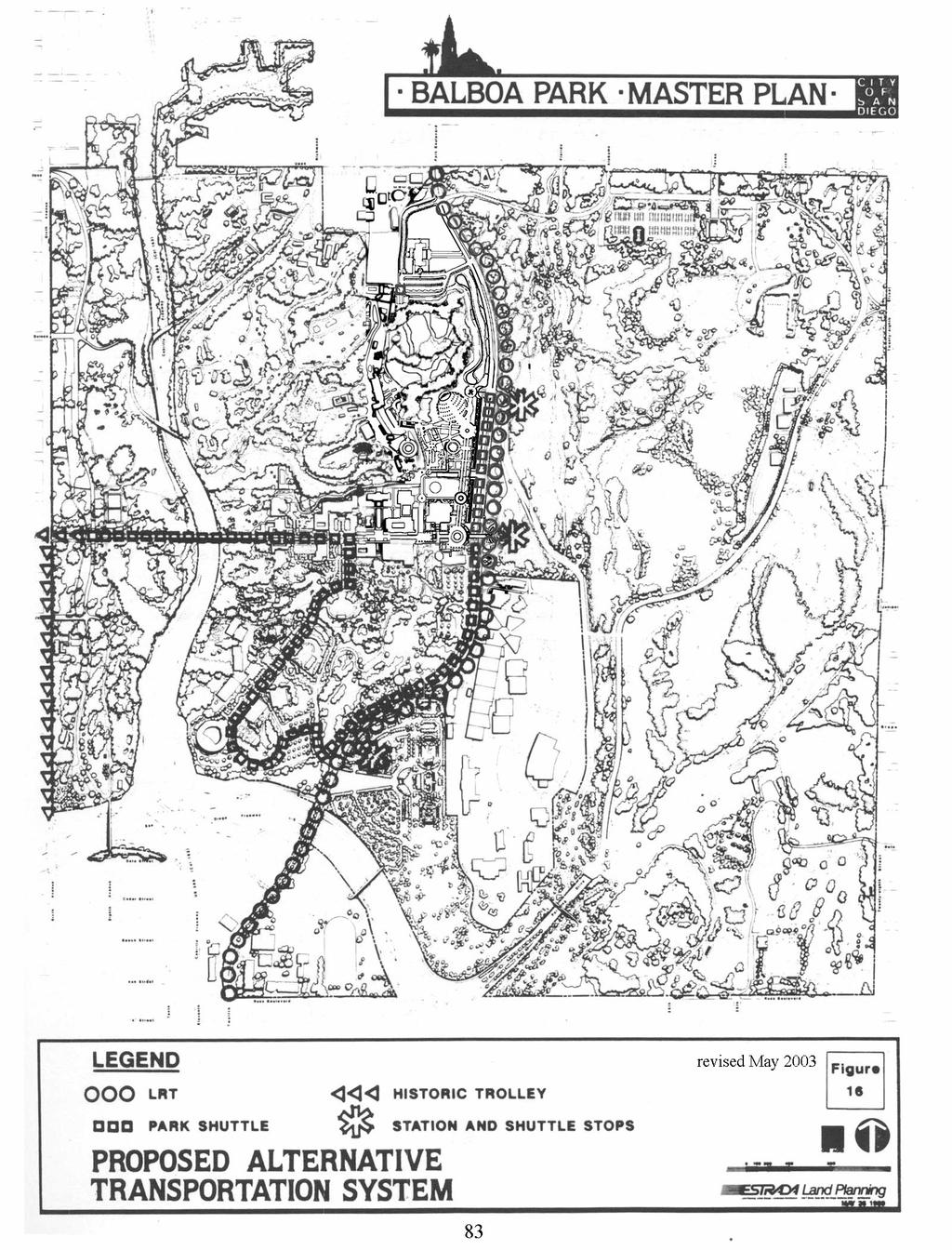
24 Build a new parking structure to serve visitors to the Prado East & Spanish Village subarea and the Zoo subarea. Build a parking structure at the Organ Pavilion to replace lost spaces. Reduce overall parking demand to Park by promoting transit to the Park. Utilize off-site parking. INTRA-PARK SHUTTLE The Inspiration Point surface lots are, in general, very poorly utilized. The poor utilization during peak weekend periods is partly because the lots are perceived to be out of walking range of destinations in the Prado area (the distance is actually less that one-half mile). A shuttle service between the lots and attractions in the Central Mesa area, including the Zoo, should be established to meet peak weekend demands. At night, problems of poor utilization of existing parking facilities is also apparent. At both the Inspiration Point and Zoo parking lots, less than five percent of the total spaces are occupied during the evening peak hours. Walking distance is a factor in the poor utilization of these parking lots during evenings in the park. The Zoo parking lot parking structure adjacent to Park Boulevard should be included in the tram system at night to encourage the utilization of the Zoo lot that parking structure by visitors to the nighttime attractions in the northern end of the Central Mesa area. The service should be established (see figure 16 for routes), with the following considerations in mind: Maximum Ten Minute Headways While the easy parking at the Inspiration Point site should serve as an incentive to use the lot, frequent tram runs must be provided to ensure the lot is well used. Signage Improvements Provisions for tram service should be accompanied by improvements to signage in the Park. The signage system should be flexible, allowing Park staff to direct visitors to certain lots as parking in the Central Mesa fills up. This approach was effective for the Zoo. During the Panda exhibit visitors were directed to overflow parking as the Zoo lot reached capacity. R.V. and Tour Bus Parking R.V. s and tour buses are most prevalent during summer weekends, and take up an inordinate amount of parking space. Special R.V. and bus parking should be established in the Inspiration Point site to remove these large vehicles from congested streets and parking areas within the Central Mesa. Arizona Landfill Site According to demand estimates, the Inspiration Point lots could accommodate spillover demands from both the Central Mesa and the Zoo during peak summer weekends. The proposed tram system should include the Zoo, so that the use of the Arizona Landfill site can be phased out and eventually reclaimed. 82
25
26 reserved for Park employees and volunteers. By reducing the amounbt of long-term employee parking in parking areas nearest the Park attractions, more convenient spaces will be available to accommodate visitor parking demands. SIGNAGE Specific recommendations pertaining to signage will benefit the parking and circulation element of Balboa Park. These recommendations are discussed in the Signage Element of this Master Plan. LOW POWER RADIO STATION To inform park visitors about current events and conditions in the Park, a small radio system is recommended for inclusion the park. Such a system could supplement a signage system for informing visitors about parking and circulation conditions. The Park should establish a radio station and include the following features for improving parking: Report parking conditions The radio station should include regular, up-to-the-minute reports on parking conditions. Location of overflow lots like Inspiration Point the availability of parking in the Central Mesa, and other special information on parking should be broadcast regularly, along with reports on special activities in the Park. Freeway signage Signs should be placed on major freeway approaches to the Park, telling Park visitors in advance of the Park of the radio station and its broadcast frequency. Promenade Parking Structure This parking structure should be constructed before the current Zoo parking lot is converted to Zoological Gardens. Adequate replacement parking must be constructed prior to any conversion of the current Zoo parking lot. Organ Pavilion Structure The Organ Pavilion structure should be phased to replace parking spaces lost in the reclamation of parking areas in the Pan American Plaza and Plaza de Panama for pedestrian uses. In scheduling construction of the structure, the following considerations should be kept in mind: - Construction should occur during the winter and spring months when Park attendance is likely to be low and the impact of losing some or all of the Organ Pavilion surface lot would be the smallest. - During construction, the tram-system should be made available to mitigate the impact of the temporary loss of the Organ Pavilion surface spaces. Transit to the Park By the Year 2000, the Park should be linked in the LRT system with rail line along Park Boulevard from Centre City to Jack Murphy Stadium. Every effort should be made to promote transit ridership to the Park when this improvement is made. In planning for the LONG RANGE PARKING STRATEGIES The following measures are more long range strategies. 86
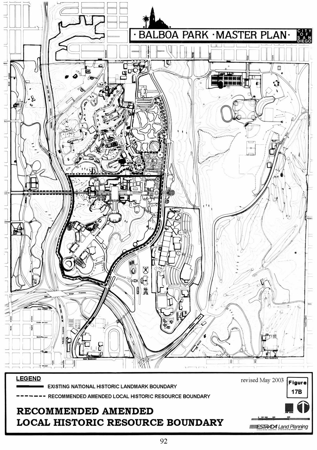
27 Historic Preservation EXISTING LOCAL AND NATIONAL HISTORIC DESIGNATION STATUS The Historical Site Board designated the El Prado Area of Balboa Park as City Historical Site Number 1 on September 7, The California Quadrangle of the El Prado area was placed on the National Register of Historic Places in May 1974, and the entire El Prado complex was placed on the Register in December In February 1978, the sites of the 1915 and 1935 Expositions, were granted National Historic Landmark (NHL) status. AMENDMENTS TO THE EXISTING STATUS ACTIONS RELATED TO HISTORIC AREA BOUNDARIES On July 27, 1988, the Historic Site Board amended the local historic site and National Historic Landmark designations to make them coterminous and to add additional contributing elements. See the boundaries on figure 17. Contributing structure to both the local San Diego and National designations are those structures which were erected for the Panama-California International Exposition of and the California Pacific International Exposition of They are the: Administration Building, Botanical Building, Cabrillo Bridge and Guard Houses, Casa de Balboa (reconstruction), Casa del Prado(reconstruction), House of Charm, House of Hospitality, Museum of Man, Spreckels Organ Pavilion, El Cid Statue, Alcazar Garden, Balboa Park Club, Conference Building and restroom, Ford Building (Aerospace Museum), Ford/Starlight Bowl, Federal Building, Hall of Nations, House of Pacific Relations, Municipal Gymnasium, Palisades Building, Spanish Village, United Nations Building, and Zoro Garden. The Natural History Museum, the San Diego Museum of Art, 89 the Merry-go-round Carousel, and the Miniature Train are also contributing structural elements. In addition, the potential exists for other structures and sites to be designated National Historic Landmarks or Local Historic Resources. Subsequent to the 1988 action calling for coterminous boundaries for the Local Historic Resource Boundary and National Historic Landmark designations, the City of San Diego was informed that this was not possible. The National Landmark boundary is exclusively for the structures and features erected for the Panama- California International Exposition of and the California Pacific International Exposition of By contrast, the local boundary recognizes a broader spectrum of structures and features of local historic interest. Figure 17A shows the local and national boundaries prior to the 2003 amendments. In 2003, Park Boulevard Promenade amendments to the Balboa Park Master Plan recommended amendments to the local historic resources boundary. The recommended amended boundaries are shown on Figure 17B. This recommendation reconfigures the boundary to keep the miniature train experience within the local historic resources boundary. THE NATIONAL REGISTER OF HISTORIC PLACES The National Register of Historic Places, administered by the Keeper of the Register, U.S. Department of the Interior, Washington, D.C., is the nation s official list of cultural resources worthy of preservation. The Register is a catalog of American culture, the tangible remains of our heritage. It is also an authoritative guide for federal, state, and local governments, and for citizen groups
28 interested in protecting and enhancing these irreplaceable elements of our cultural environment. Properties listed in the National Register are eligible for a variety of benefits including grants, loans, tax (cont d. on page 93) 90
29
30
31
32

33
34 Develop northeast corner of the park Signage Complete Rose Garden Miscellaneous Minor Improvements at $250,000 per year Close Florida Drive, implement Florida Canyon Master Plan Landscape Zoo parking lot Total Phase I (By Zoo) $50.35 Million 125
35 Phase IV: FY 2004 FY 2008 OBJECTIVES: Reduce vehicle pedestrian conflicts Actions: Consider closing Cabrillo Bridge to automobile traffic if transit, off-site parking, and shuttle system are adequately serving the Park. Build Park Promenade, parking structure, and greenbelt. IMPROVEMENTS: COST IN MILLIONS - Tram system Central Mesa-East Mesa pedestrian/bicycle bridge Expand House of Pacific Relations Rehabilitate War Memorial Building/ add therapeutic pool Eighth Avenue pedestrian/bicycle bridge Reclaim water tank area Miscellaneous minor improvements at $250,000 per year 1.25 TOTAL PHASE IV = $6.35 Million GRAND TOTAL PHASES = $100.2 MILLION (1989 PLAN) Phase IV - Amendment in 2003 Park Boulevard Promenade, Park Boulevard greenbelt, parking structure, plazas $207.5 million (2003 dollars) Project descriptions, scheduling and cost estimates are preliminary and are subject to change with the approval of the City Council. 128
36 (R ) RESOLUTION NUMBER R ADOPTED ON APRIL 13, 2004 WHEREAS, the San Diego Zoological Society of San Diego, Permittee, filed an application with the City of San Diego for a Site Development Permit [SDP 48083] to construct the Park Boulevard Promenade Project, located west of Park Boulevard in the Central Mesa Precise Plan area of Balboa Park; and WHEREAS, on January 15, 2004, the Planning Commission of the City of San Diego considered Site Development Permit No voted to recommend City Council approval of the permit; and WHEREAS, the matter was set for public hearing on April 13, 2004, testimony having been heard, evidence having been submitted, and the City Council having fully considered the matter and being fully advised concerning the same; NOW, THEREFORE, BE IT RESOLVED, by the City Council of the City of San Diego, that it adopts the following findings with respect to Site Development Permit No : A. SITE DEVELOPMENT PERMIT. 1. The Proposed Development Will Not Adversely Affect The Applicable Land Use Plan. The proposed Park Boulevard Promenade Project [Project] is located near the center of Balboa Park [Park] and lies within and is subject to the Balboa Park Master Plan [Master Plan] and the Central Mesa Precise Plan [Precise Plan]. With the adoption of the proposed amendments to the Master Plan and Precise Plan, the Project would not result in a land use which is inconsistent with the adopted plan designations for the site or conflict with any applicable land use plan, policy, or regulation of an agency with jurisdiction over the Project. -PAGE 1 OF 6-
37 The Project is consistent with the goals, policies and recommendations set forth in the Master Plan and the Precise Plan including: (I) improving internal circulation, avoiding automobile and pedestrian conflicts and creating a pedestrian-oriented environment; (ii) preserving and increasing free and open parkland; (iii) preserving and expanding recreational opportunities in the Park; and (iv) preserving and protecting historical resources in the Park. The Project would not result in a conflict with applicable goals, policies, and recommendations relating to circulation movements, including impacts on existing vehicular access and internal circulation, pedestrian circulation and public transit within the Park. Project-related alterations to the internal circulation of the Park would be consistent with the Master Plan goals of making the Park a more pedestrian-orientated environment, reducing automobile and pedestrian conflicts, and minimizing through traffic. The Project would also be consistent with the Precise Plan with regard to the goals for pedestrian circulation and would improve the pedestrian connection on the west side of Park Boulevard through the provision of greenbelt and meandering walkway. The Project would increase transit accessibility to the Park by accommodating alternative transportation at the transportation center in the parking structure. With respect to free and open parkland, the Project would not result in a conflict with the goals, policies, and recommendations of the Master Plan or Precise Plan. The Project would result in a net increase of free and open parkland and would not affect accessibility to other adjacent open public parkland. Consequently, the Project would be consistent with the Master Plan goal of preserving, enhancing, and increasing free and open parkland. With respect to recreational resources, the Project would not result in a conflict with the goals, policies, and recommendations of the Master Plan or Precise Plan. The Project includes the development of numerous recreational resources, including: the Zoo, Miniature Train, Carousel, new Park Boulevard greenbelt, and useable public open space, such as lawns and plazas, which would be consistent with the Master Plan goal of preserving and enhancing active and passive recreational uses in the Park. With respect to historical resources, the Project would not result in significant impacts to the National Historic Landmark [NHL] buildings and structures. The proposed project does not propose any changes to NHL properties save to implement reopening former entrances into Spanish Village - recommendations already in the Precise Plan. A portion of the proposed promenade and the western terminus of the relocated pedestrian bridge would be located within the NHL. However, there would be no direct or indirect impacts, because the design, feeling, setting, and location of the proposed promenade would conform to the National Park Service guidelines for new construction within National Historic landmarks and the U.S. Secretary of Interior s Standards for the Treatment of Historic Properties, Standards for Rehabilitation. The Project would affect two - the Carousel and Miniature Train, and would have the potential to result in a significant impact to these historical resources. However, such impacts are mitigated to below a level of significance through implementation of required mitigation measures called for in the EIR and through compliance with the City's Historical Resources Regulations. Consequently, the Project is consistent with the Master Plan policy of preserving, maintaining, and enhancing contributing elements to the local and national historic resources. -PAGE 2 OF 6-
38 Therefore, the Project would not result in a conflict with or adversely impact the relevant goals, policies, and recommendations of the Master Plan and Precise Plan. 2. The Proposed Development Will Not Be Detrimental To The Public Health, Safety, and Welfare. The effect of the Project is to improve vehicular and pedestrian circulation and access to the Park and to enhance recreational resources in the Park. The Project will improve public health and safety by improving internal circulation in the Park, reducing automobile and pedestrian conflicts, improving vehicular access and improving public transit in the Park. According to the City s Police and Fire Departments, current police and fire protection in the Park area would be adequate to serve the proposed project, and no additional police or fire services would be required. Therefore, no significant impact to public services would occur from the proposed project. In addition, all Uniform Building, Fire, Plumbing, Electrical and Mechanical Codes and City, state and federal regulations governing the construction and continued operation of development apply to this Project to prevent adverse affects to those persons or properties in the vicinity. Therefore, the Project and proposed development will not be detrimental to the public health, safety, and welfare. 3. The Proposed Development Will Comply With The Applicable Regulations Of The Land Development Code. The Project will comply with all applicable regulations of the Land Development Code, including the Historical Resources Regulations. The Historical Resources Regulations would apply to the relocation of the Carousel and the Miniature Train, as well as the portions of the proposed project located within the designated National Historic Landmark. As described in Section (c) of the Historical Resources Regulations, development affecting designated historical resources or historical districts shall, as a condition of the project approval, provide full mitigation for the impact to the resource, in accordance with the Historical Resources Guidelines of the Land Development Code. As stated above, all potential impacts to historical resources are mitigated to below a level of significance through implementation of required mitigation measures, which are required as conditions of approval for the Project. Moreover, the existing and proposed uses are consistent with the Land Development Code provisions pertaining to publicly dedicated parkland which is designated as an Open Space Park [OP] zone. The operation of zoological gardens (as a primary use) and public parking facilities (as an accessory or incidental use) are allowable uses within the OP zone designation. Finally, although there are no specific standards set forth in the Land Development Code with respect to land designated as an OP zone, the Project incorporates height, building scale, and setback requirements. Therefore, the Project and proposed development will comply with the applicable regulations of the Land Development Code. -PAGE 3 OF 6-
39 B. SUPPLEMENTAL SITE DEVELOPMENT PERMIT FINDINGS FOR RELOCATION OF DESIGNATED HISTORICAL RESOURCES LDC SECTION (h). 1. There Are No Feasible Measures, Including Maintaining The Resource On Site, That Further Minimize The Potential Adverse Affects On Historical Resources. There are no feasible measures that can further minimize the potential adverse affects on the Carousel and Miniature Train through their relocation. Relocating the resources would, in fact, result in their complete documentation, repair, and restoration through implementation of the required Mitigation, Monitoring and Reporting Program. Maintaining the resources on site would significantly reduce the ability of the project to provide the number of parking spaces required as a result of the conversion of the existing zoo parking lot to exhibit space and access/egress to the parking garage could not be taken at the Park Boulevard/Zoo Place intersection. This would have other potential transportation, circulation and land use conflicts with the existing Balboa Park Master Plan. Alternative parking garage locations analyzed in the Environmental Impact Report were found to be unreasonable and/or infeasible because of the potential adverse impacts to transportation/circulation, land use conflicts, and other historic resources such as the War Memorial Building. 2. The Proposed Relocation Will Not Destroy The Historical, Cultural, Or Architectural Values Of The Historical Resource, And The Relocation Is Part Of A Definitive Series Of Actions That Will Assure The Preservation Of The Designated Historical Resources. The Carousel and the Miniature Train are locally designated historic resources but are not within, nor do they contribute to, the National Historic Landmark stats of the Park, and, they would not be relocated within the existing NHL boundary. Neither resource was built nor installed in the Park within the period of significance of the Landmark. Thus, relocating the Carousel and Miniature Train would not diminish the overall historic character of the Park. Relocating the Carousel and Miniature Train would result in their complete documentation, report, and restoration through implementation of the required Mitigation, Monitoring and Reporting Program. Thus their relocation will result in a series of actions that will assure the preservation of the resources. The relocation will not destroy the historical, cultural, or architectural values of the Carousel and Miniature Train. Carousels are designed to be moved and this one has already been relocated and this one has already been relocated at least three times. With regard to a property that is designed to move or has been frequently moved during its historic use, the National Park Service recommends that the property must be located in a historically appropriate setting, retaining its integrity of setting, design, feeling, and association. The Carousel would be moved approximately 300 feet southwest, adjacent to the Spanish Village. The proposed new location would enhance the setting, design, feeling, and association within Balboa Park by providing a more formally landscaped environment for the ride. The Carousel would remain in the same general location within Balboa Park that has been familiar to San Diegans for the last 80 years. The new location would be somewhat more intimate with -PAGE 4 OF 6-
40 closer proximity to landscaping and the exterior facade of Spanish Village than currently exists. This would change the ability to view the barn at a distance, but the setting to the enclosed Carousel itself would not change. It would also become a more integral part of the Balboa Park experience by its proximity to the major pedestrian access way that would be the proposed Park Boulevard Promenade. The experience of the ride would change little because the Carousel operates within the barn-like structure. The Carousel and ticket booth would be preserved in the same orientation to each other in their new locations as in their existing location. Although the outer housing has been modified in the past, the current appearance of the outer housing would also be reproduced in the new location. The integrity of setting, design, feeling, and association would be retained at the new location. With regards to the miniature train, the project would move the train to the north of Zoo Place along the west side of Park Boulevard. Relocation would have an impact on the location, setting, and feeling of the resource. However, the integrity of the train s design, setting, and feeling has been altered over time with changes to the alignment, landscaping, physical appearance and hardware. Project mitigation includes; landscaping at the new location to approximate the parkline feeling and setting; documentation of the existing layout, landscaping plan and appearance; signage, incorporation of original ride elements into the new location design including a tunnel and viewing opportunities to watch and photograph passengers. With these mitigation measures, the new location of the train will have a similar design, setting and feeling as the historic location. The train will also continue its historical function of providing an active recreational amenity within Balboa Park. 3. There Are Special Circumstances Or Conditions Apart From The Existence Of Historical Resources, Applying To The Land That Are Peculiar To The Land And Are Not Of The Applicant's Making, Whereby The Strict Application Of The Provisions Of The Historical Resources Regulations Would Deprive The Property Owner Of Reasonable Use Of The Land. The special circumstance that applies in this instance is that the project is located on public land in the city's most significant and historic park where any determination of reasonable use of the land is a public policy issue undertaken by the city Council with full knowledge and public disclosure of the issues, trade-offs, necessary regulations, mitigation measures and protection of public resources. Because the Zoological Society wishes to expand the area that is used for exhibiting animals by converting the majority of the existing zoo parking lot (their lease area) into exhibit space. This creates a requirement to address both the parking needs of the Zoo and other park institutions. To address these needs, the city council must approve amendments to the Balboa Park Master Plan and Central Mesa Precise Plan in order to provide the appropriate policy guidance as to how this replacement parking is to be sited, designed, and developed. There is limited land available in Balboa Park and these alternatives available for locating replacement parking given the existing public policy restrictions on development within the park. Constructing the Park Boulevard Promenade, Project, as proposed, addresses other existing goals and recommendations of the master and precise plans such as: providing a better pedestrian linkage between the Zoo entrance and the Prado; reducing traffic/pedestrian conflicts. -PAGE 5 OF 6-
41 The public nature of the Park, the nature, and restrictions on citing development in the park and lease arrangements within the park are special circumstances applying to the land which are not of the applicant's making. Not allowing the relocation of the two locally designated historic resources further forecloses the options and alternatives available to the city council to address a major public policy issue. The above findings are supported by the minutes, maps and exhibits, all of which are herein incorporated by reference. BE IT FURTHER RESOLVED, that the recommendation of the Planning Commission is sustained, and Site Development Permit No is granted to the Zoological Society of San Diego, Permittee, under the terms and conditions set forth in the attached permit which is made a part of this resolution. APPROVED: CASEY GWINN, City Attorney By Prescilla Dugard Deputy City Attorney PD:dm 04/16/04 Or.Dept:Dev.Svcs. R PAGE 6 OF 6-
DATE ISSUED: March 12, 2014 REPORT NO: 101. Old Globe Way Improvements and San Diego Zoo Employee Parking Structure
 DATE ISSUED: REPORT NO: 101 ATTENTION: SUBJECT: Park and Recreation Board Agenda of March 20, 2014 Old Globe Way Improvements and San Diego Zoo Employee Parking Structure SUMMARY Issue Should the Park
RESOLUTION NO. R Refining the route, profile and stations for the Downtown Redmond Link Extension
 RESOLUTION NO. R2018-32 Refining the route, profile and stations for the Downtown Redmond Link Extension MEETING: DATE: TYPE OF ACTION: STAFF CONTACT: Capital Committee Board PROPOSED ACTION 09/13/2018
The transportation system in a community is an
 7 TRANSPORTATION The transportation system in a community is an important factor contributing to the quality of life of the residents. Without a sound transportation system to bring both goods and patrons
DRAFT MAP AMENDMENT FLU 04-4
 DRAFT MAP AMENDMENT FLU 04-4 SW 24 TH AVENUE ROADWAY CORRIDOR The University of Florida participates with the Metropolitan Transportation Planning Organization (MTPO) in its responsibilities for the continuing,
Mark-up of the effect of the proposed Bronte Village Growth Area OPA No.18 on the text of section 24, Bronte Village, of the Livable Oakville Plan
 Mark-up of the effect of the proposed Bronte Village Growth Area OPA No.18 on the text of section 24, Bronte Village, of the Livable Oakville Plan Notes: This document is provided for information purposes
A. INTRODUCTION B. PROJECT LOCATION
 Chapter 1: Project Description A. INTRODUCTION The Lower Manhattan Development Corporation (LMDC), a subsidiary of the New York State Urban Development Corporation, doing business as the Empire State Development
City of Farmington. Downtown Plan. Amendment to the 1998 Master Plan Adopted October 11, 2004
 City of Farmington Amendment to the 1998 Master Plan Adopted October 11, 2004 Introduction Planning Background 1 Scope and Components of the Plan Amendment 2 Concept Introduction 3 Plan Concepts 3 Conceptual
Chapter Master Planned Communities (MPC) District
 District") Sections 14.53.010 Purpose and Intent 14.53.020 Applicability 14.53.030 Procedure 14.53.040 MPC Standards 14.53.050 Required Findings 14.53.010 Purpose and Intent Chapter 14.53 Master Planned Communities
Sections 14.53.010 Purpose and Intent 14.53.020 Applicability 14.53.030 Procedure 14.53.040 MPC Standards 14.53.050 Required Findings 14.53.010 Purpose and Intent Chapter 14.53 Master Planned Communities
6. REGIONAL AND COMMUNITY FACILITIES DESIGNATIONS 6.1. OBJECTIVES FOR REGIONAL AND COMMUNITY FACILITIES LAND USE DESIGNATIONS
 6. REGIONAL AND COMMUNITY FACILITIES DESIGNATIONS INTRODUCTION The Regional and land use designations provide the primary locations for uses which satisfy the health, education and other service needs
Clairtrell Area Context Plan
 Clairtrell Area Context Plan March 2005 Urban Development Services City Planning Contents 1. Introduction... 4 2. Development Structure... 6 2.1 Streets... 7 2.1.1 Sheppard Avenue and Bayview Avenue...
A. WHAT IS A GENERAL PLAN?
 I. Introduction A. WHAT IS A GENERAL PLAN? A general plan is the planning guideline for the future of a city. It contains goals and policies which regulate urban development, the protection of the natural
ARLINGTON COUNTY, VIRGINIA. County Board Agenda Item Meeting of January 28, 2017 SUPPLEMENTAL REPORT-2
 ARLINGTON COUNTY, VIRGINIA County Board Agenda Item Meeting of January 28, 2017 SUPPLEMENTAL REPORT-2 DATE: January 27, 2017 SUBJECT: The Virginia Department of Transportation s Transform I-66 Inside the
COMMUNITY DESIGN. GOAL: Create livable and attractive communities. Intent
 COMMUNITY DESIGN Intent An attractive, well-designed County will attract quality development, instill civic pride, improve the visual character of the community, and create a strong, positive image for
ARLINGTON COUNTY, VIRGINIA. County Board Agenda Item Meeting of January 28, 2017 SUPPLEMENTAL REPORT
 ARLINGTON COUNTY, VIRGINIA County Board Agenda Item Meeting of January 28, 2017 SUPPLEMENTAL REPORT DATE: January 26, 2017 SUBJECT: The Virginia Department of Transportation s Transform I-66 Inside the
ORDINANCE WHEREAS, this Ordinance is consistent with the City of Winter Garden Comprehensive Plan; and
 ORDINANCE 17-06 AN ORDINANCE OF THE CITY COMMISSION OF THE CITY OF WINTER GARDEN, FLORIDA, CREATING ARTICLE XIV OF CHAPTER 118 OF THE CITY OF WINTER GARDEN CODE OF ORDINANCES PROVIDING FOR THE EAST PLANT
Balboa Park Plaza de Panama Project
 Environmental Impact Report for the Balboa Park Plaza de Panama Project Project No. 233958 SCH No. 2011031074 January 23, 2012 The City of San Diego DEVELOPMENT SERVICES DEPARTMENT Date of Notice: Monday,
Illustration of Eastlake Farmer s Cooperative Grain Elevator. Chapter 5: implementation 5-1
 Illustration of Eastlake Farmer s Cooperative Grain Elevator Chapter 5: implementation 5-1 chapter 5: implementation Introduction The Eastlake Subarea Plan includes a wide range of recommendations intended
Gold Line Bus Rapid Transit Transit Oriented Development (BRTOD) Helmo Station Area Plan
 Helmo Station Area Plan") Appendix F Gold Line Bus Rapid Transit Transit Oriented Development (BRTOD) Helmo Station Area Plan Introduction and Purpose of the Plan The Gold Line Bus Rapid Transit facility is an eleven-mile dedicated
Appendix F Gold Line Bus Rapid Transit Transit Oriented Development (BRTOD) Helmo Station Area Plan Introduction and Purpose of the Plan The Gold Line Bus Rapid Transit facility is an eleven-mile dedicated
The University District envisions, in its neighborhood
 Envisioning the University District Link Light Rail in Seattle s neighborhoods CIY OF SEALE CONCEP-LEVEL SAION AREA PLANNING RECOMMENDAION RESOLUION # 30165 EXHIBI L Vision 08.2000 he University District
CITY OF ALAMEDA PLANNING BOARD Draft RESOLUTION
 CITY OF ALAMEDA PLANNING BOARD Draft RESOLUTION A RESOLUTION OF THE PLANNING BOARD OF THE CITY OF ALAMEDA APPROVING DESIGN REVIEW AND DEVELOPMENT PLAN AMENDMENT APPLICATION PLN13-0157 TO CONSTRUCT ELEVEN
CHAPTER 1. Ms. Guajardo s Class - Central Elementary CH 1 1
 INTRODUCTION CHAPTER 1 Ms. Guajardo s Class - Central Elementary CH 1 1 1.1 SETTING South Centre City is a linear corridor south of Downtown Escondido paralleling Centre City Parkway and South Escondido
ELMVALE ACRES SHOPPING CENTRE MASTER PLAN
 ELMVALE ACRES SHOPPING CENTRE MASTER PLAN Contents 1.0 INTRODUCTION... 2 2.0 LOCATION... 2 3.0 EXISTING CONTEXT... 2 4.0 VISION & GUIDING PRINCIPLES... 2 5.0 LAND USE AND BUILT FORM... 4 5.1 St. Laurent
TRANSPORTATION ELEMENT GOALS, OBJECTIVES, AND POLICIES
 TRANSPORTATION ELEMENT GOALS, OBJECTIVES, AND POLICIES GOAL 2 The City shall provide a safe, convenient, effective, and energy efficient multimodal transportation system which is coordinated with the Future
Venice Pumping Plant Dual Force Main Project Draft EIR
 City of Los Angeles 5.9 LAND USE PLANS 5.9.1 Environmental Setting Venice Pumping Plant Dual Force Main Project Draft EIR The Project lies within the bounds of Los Angeles County and the City of Los Angeles.
AMEND DMENT H HOSPITAL
 AMEND DMENT TO LAND USE PLAN ELEMENT VILLAGE OF RIDGEWOOD MASTER PLAN H HOSPITAL ZONE DISTRICT Village of Ridgewood Planning Board February 28, 2014with technical revisions from June 9, 2014 Planning Board
THE 355/270 CORRIDOR:
 THE 355/270 CORRIDOR: Strategic Ideas for Sustaining a Livable Work Place Project Summary ACCESS LIFE DESIGN HEALTH WORK Montgomery County Planning Department The Maryland-National Capital Park and Planning
ARLINGTON COUNTY, VIRGINIA
 ARLINGTON COUNTY, VIRGINIA County Board Agenda Item Meeting October 15, 2005 DATE: September 28, 2005 SUBJECT: Request to Advertise the adoption of the 2005 Clarendon Sector Plan C. M. RECOMMENDATION:
12 January 12, 2011 Public Hearing APPLICANT: TAILWIND DEVELOPMENT GROUP,LLC PROPERTY OWNER: CITY OF VIRGINIA BEACH
 12 January 12, 2011 Public Hearing APPLICANT: TAILWIND DEVELOPMENT GROUP,LLC PROPERTY OWNER: CITY OF VIRGINIA BEACH STAFF PLANNER: Faith Christie REQUEST: Conditional Change of Zoning (from PD-H1 Planned
SBCAG STAFF REPORT. MEETING DATE: March 17, 2016 AGENDA ITEM: 5I
 SBCAG STAFF REPORT SUBJECT: Cabrillo-UPRR Bridge Project MEETING DATE: March 17, 2016 AGENDA ITEM: 5I STAFF CONTACT: Fred Luna RECOMMENDATION: Authorize the chair to sign a Memorandum of Understanding
Goal 1: To Encourage the Orderly, Harmonious and Judicious Use of University Resources in the Development of University Land.
 2.0 Future Land Use Goal 1: To Encourage the Orderly, Harmonious and Judicious Use of University Resources in the Development of University Land. Objective 1.1: Make available future building sites that
EXHIBIT A. Tax Increment Reinvestment Zone No. 1 (Town Center) First Amended Project Plan 1
 First Amended Project Plan 1") EXHIBIT A Tax Increment Reinvestment Zone No. 1 (Town Center) First Amended Project Plan 1 1 As amended by Resolution No. 2008-02-001(TR1R) of the Tax Increment Reinvestment Zone No.1, and approved to
EXHIBIT A Tax Increment Reinvestment Zone No. 1 (Town Center) First Amended Project Plan 1 1 As amended by Resolution No. 2008-02-001(TR1R) of the Tax Increment Reinvestment Zone No.1, and approved to
Transportation. Strategies for Action
 Transportation A major priority for the Overlake Neighborhood is to develop a multimodal transportation system. To achieve this system, a balance has to be found among travel, circulation and access needs;
3. VISION AND GOALS. Vision Statement. Goals, Objectives and Policies
 Vision Statement Queen Creek s interconnected network of parks, trails, open spaces and recreation opportunities provide safe and diverse activities and programs that sustain its unique, small town, equestrian
Appendix E Section 4(f) Evaluation
 Evaluation") Appendix E Section 4(f) Evaluation Appendix E Draft Section 4(f) Evaluation E.1 Introduction This appendix addresses a federal regulation known as Section 4(f), which protects parks, recreation areas,
Appendix E Section 4(f) Evaluation Appendix E Draft Section 4(f) Evaluation E.1 Introduction This appendix addresses a federal regulation known as Section 4(f), which protects parks, recreation areas,
CITY OF KEIZER MASTER PLAN APPLICATION & INFORMATION SHEET
 CITY OF KEIZER MASTER PLAN APPLICATION & INFORMATION SHEET PRE-APPLICATION CONFERENCE Prior to the actual filing of a Master Plan application, it is strongly recommended that the applicant contact Planning
A. Background Summary of Existing Challenges and Potential Possibilities. 1. Summary of Existing Assets and Potential Opportunities
 A. Background 1 A Main Street Master Plan Study was performed and completed in October of 2007. The study was initiated to review current land uses and development patterns along Main Street, from Parrish
McCowan Precinct Plan Study Background & Deliverables
 1 DRAFT & WITHOUT PREJUDICE McCowan Precinct Plan Study Background & Deliverables In September, 2011, City Planning (Scarborough District) began a study of an area within the Scarborough Centre, identified
2.7 ac park. TOTAL 5,403 DU 1,297,900 sf 1,105,450 sf 3.87 ac 5,563 DU 1,121,200 sf 1,105,450 sf 3.87 ac
 PLAN AMENDMENT 2013-I-B1: SEVEN CORNERS SPECIAL STUDY Summary of Pre-staffing Comments Planner: Bernard Suchicital bsuchi@fairfaxcounty.gov (703) 324-1254 Background On October 29, 2013, the Board of Supervisors
R E S O L U T I O N. Single-Family Residence/ Church. 2,488 sq. ft. 2,488 sq. ft. Area Parking Required: Church
 R E S O L U T I O N WHEREAS, the Prince George s County Planning Board is charged with the approval of Detailed Site Plans pursuant to Part 3, Division 9 of the Zoning Ordinance of the Prince George s
Northern Branch Corridor SDEIS March Table of Contents
 Table of Contents Executive Summary... ES-1 ES.1 Introduction... ES-1 ES.2 Project Background... ES-1 ES.3 Purpose and Need... ES-5 ES.4 Alternatives... ES-6 ES.5 Operating Plan... ES-11 ES.6 Cost Analysis...
ARLINGTON COUNTY, VIRGINIA
 ARLINGTON COUNTY, VIRGINIA County Board Agenda Item Meeting of April 23, 2019 DATE: April 12, 2019 SUBJECT: SP #413 SITE PLAN AMENDMENT to permit a fixed bar in a private outdoor café space with associated
Volume 2: Implementation Plan
 Volume 2: Implementation Plan February 25 th 2002 Implementation Introduction This document outlines the steps that should be taken to implement the Washington Heights Neighborhood Plan. The City Council
Regulation Changes for Open Space and Similar Uses
 Regulation Changes for Open Space and Similar Uses What is the Project? This project is an analysis of the Zoning Ordinance relating to public lands and open space regulations. The proposed text amendments
Preci nct P l ans Figure 56 Campus Aerial Photo, 2008 CAL STATE EAST BAY, HAYWARD CAMPUS MASTER PLAN
 9 Precinct Plans This section contains a detailed discussion of the planning and design concepts for specific areas or precincts of the Cal State East Bay Hayward campus. The Precinct Plans pertain to
ARLINGTON COUNTY, VIRGINIA
 ARLINGTON COUNTY, VIRGINIA County Board Agenda Item Meeting of April 12, 2014 DATE: April 2, 2014 SUBJECT: to the Arlington County Zoning Ordinance, Article 11.1 "CP-FBC" Columbia Pike Form Based Code
URBAN DESIGN BRIEF URBAN DESIGN BRIEF 721 FRANKLIN BLVD, CAMBRIDGE August 2018
 URBAN DESIGN BRIEF URBAN DESIGN BRIEF 721 FRANKLIN BLVD, CAMBRIDGE August 2018 DESIGN BRIEF CONTENTS PART A 1.0 INTRODUCTION 2.0 DESCRIPTION & ANALYSIS OF SITE CONTEXT 3.0 DESIGN CONSTRAINTS AND OPPORTUNITIES
UAA School of Engineering Parking Garage Master Plan Amendment. 1. Purpose
 UAA School of Engineering Parking Garage Master Plan Amendment 1. Purpose Since the UAA campus master plan was drafted in 2003, adopted in 2004, and amended in 2009 a number of significant changes regarding
Westwind Developments Ltd. PIONEER LANDS AREA STRUCTURE PLAN - PROPOSED AMENDMENT
 FEBRUARY 2013 TABLE OF CONTENTS 1.0 BACKGROUND... 1 1.1 Amendment... 1 2.0 LOCATION & CONTEXT... 2 2.1 Land Ownership... 2 3.0 POLICY CONTEXT... 3 3.1 Municipal Development Plan... 3 3.2 Capital Region
Historic Preservation Element
 Casa Gardens by Carolyn Pelkey Historic Preservation Element Incorporated in 1928, the City of San Clemente was among the first master planned communities in the U.S. built from open grazing land. Before
Planning Commission Staff Report June 5, 2008
 Owner/Applicant Taylor Village Sacramento Investments Partners, LP c/o Kim Whitney 1792 Tribute Road #270 Sacramento, CA 95815 Staff Recommendation Planning Commission Staff Report Project: File: Request:
CITY OF CHARLOTTESVILLE, VIRGINIA CITY COUNCIL AGENDA
 CITY OF CHARLOTTESVILLE, VIRGINIA CITY COUNCIL AGENDA Agenda Date: December 16, 2013 Action Required: Adoption of Resolution Presenter: Staff Contacts: Title: James E. Tolbert, AICP, Director of NDS James
Town of Portola Valley General Plan. Nathhorst Triangle Area Plan
 Town of Portola Valley General Plan Amended December 10, 1997 Table of Contents Introduction... 1 Planning Area... 1 Objectives... 2 Principles... 2 Standards... 4 Description... 4 Community Commercial...
PLANNING JUSTIFICATION REPORT
 PLANNING JUSTIFICATION REPORT 55 DELHI STREET CITY OF GUELPH PREPARED FOR: VESTERRA PROPERTY MANAGEMENT PREPARED BY: LABRECHE PATTERSON & ASSOCIATES INC. SCOTT PATTERSON, BA, CPT, MCIP, RPP PRINCIPAL,
OFFICE CONSOLIDATION SECONDARY PLAN AREA 22 THE BRAMALEA SOUTH INDUSTRIAL SECONDARY PLAN
 OFFICE CONSOLIDATION SECONDARY PLAN AREA 22 THE BRAMALEA SOUTH INDUSTRIAL SECONDARY PLAN November 2010 EXPLANATORY NOTES (Secondary Plan Area 22) General (pertaining to all secondary plan office consolidations)
ROAD CLOSURE AND LAND USE AMENDMENT SILVER SPRINGS (WARD 1) NORTHEAST OF NOSEHILL DRIVE NW AND SILVER SPRINGS ROAD NW BYLAWS 2C2018 AND 29D2018
 NORTHEAST OF NOSEHILL DRIVE NW AND SILVER SPRINGS ROAD NW BYLAWS 2C2018 AND 29D2018") Page 1 of 19 EXECUTIVE SUMMARY This application proposes redesignating two parcels in the community of Silver Springs from Special Purpose Future Urban Development (S-FUD) District and undesignated road
Page 1 of 19 EXECUTIVE SUMMARY This application proposes redesignating two parcels in the community of Silver Springs from Special Purpose Future Urban Development (S-FUD) District and undesignated road
LOS ANGELES CITY PLANNING DEPARTMENT STAFF REPORT
 LOS ANGELES CITY PLANNING DEPARTMENT STAFF REPORT LOS ANGELES CITY PLANNING COMMISSION CASE NO: CPC 2006-9374 CRA CEQA: Exempt DATE: December 21, 2006 Location: Valley Plaza and Laurel Plaza TIME: after
PLANNING REPORT CITY OF EAGAN. APPLICANT: Cedar Grove Hospitality, LLC HEARING DATE: December 18, 2014
 PLANNING REPORT CITY OF EAGAN REPORT DATE: December 8, 2014 CASE: 19-PA-11-11-14 APPLICANT: Cedar Grove Hospitality, LLC HEARING DATE: PROPERTY OWNER: The Flats at Cedar APPLICATION DATE: Nov. 21, 2014
CHARLES PUTMAN CHARLES PUTMAN AND ASSOCIATES, INC
 MEMORANDUM CHARLES PUTMAN & ASSOCIATES, INC. LAND DEVELOPMENT CONSULTANTS PLANNING ZONING PERMITTING 4722 NW Boca Raton Boulevard, Suite C-106 Boca Raton, Florida 33431 Phone: 561/994-6411 FAX: 561/994-0447
1120 Haist Street - Pelham Arena Community Co-Design Recommendation Report Haist Street - Pelham Arena Community Co-Design Recommendation Report
 1120 Haist Street - Pelham Arena Community Co-Design Executive Summary: In May, 2017 the Town retained the services of The Planning Partnership to undertake a community design charrette process to determine
LUNDY S LANE COMMUNITY IMPROVEMENT PLAN STUDY
 PUBLIC INFORMATION MEETING #2 October 12, 2016 LUNDY S LANE COMMUNITY IMPROVEMENT PLAN STUDY AGENDA 5:00 to 5:30pm: Open House 5:30 to 6:15pm: Presentation 6:15 to 7:00pm: Individual paced workshop with
Planned Development Review Revisions (Project No. PLNPCM )
") Planned Development Review Revisions (Project No. PLNPCM2014-00139) Standard residential development Planned Development Example: Smaller lot sizes than what is allowed to create open space amenity. What
Planned Development Review Revisions (Project No. PLNPCM2014-00139) Standard residential development Planned Development Example: Smaller lot sizes than what is allowed to create open space amenity. What
SPRINGHILL LAKE TRANSIT VILLAGE
 Greenbelt Metro Area Sector Plan - Subarea Design Policies and Guidelines - Springhill Lake Transit Village 113 SPRINGHILL LAKE TRANSIT VILLAGE Residential Neighborhood and Village Center CONCEPT Springhill
Workshop 3. City of Burlington Waterfront Hotel Planning Study. September 14, The Planning Partnership
 Workshop 3 City of Burlington Waterfront Hotel Planning Study September 14, 2017 The Planning Partnership The Waterfront Hotel Planning Study 01 The Brant & Lakeshore Planning Study will establish a Strategic
WHEREAS, after consideration of the evidence presented at the public hearing on January 14, 2010, the Prince George's County Planning Board finds:
 R E S O L U T I O N WHEREAS, the Prince George s County Planning Board has reviewed DDS-600 requesting a departure for the location of two loading spaces without driveway access along Toledo Terrace in
GUIDELINES EXHIBITION PLACE LOCATION: OBJECTIVES. Structure Plan URBAN DESIGN GUIDELINES
 Development in the Exhibition Place lands will be consistent with the following urban design guidelines. They provide a framework for new development of the lands and are to be read in conjunction with
East Panorama Ridge Concept Plan Amendment
 Page 1 of 7 L003 : East Panorama Ridge Concept Plan Amendment Corporate NO: L003 Report COUNCIL DATE: March 4, 2002 REGULAR COUNCIL LAND USE TO: Mayor & Council DATE: February 27, 2002 FROM: General Manager,
Moreno Valley College: Conceptual Master Planning - Site Analysis Lasselle Street, Moreno Valley, CA 92551
 Master Plan Architect School Name Moreno Valley College District Riverside Community College District Architecture and Urban Design 5898 Blackwelder Street Ground Floor Culver City, CA 90232 T: 310.559.5720
City of Toronto. Emery Village Transportation Master Plan
 City of Toronto Emery Village Transportation Master Plan May 2009 Emery Village Transportation Master Plan Toronto, ON May 2009 Consulting Inc. 100 York Blvd., Suite 300 Richmond Hill, ON L4B 1J8 Tel:
PROJECT BACKGROUND. Preliminary Design Scope and Tasks
 PROJECT BACKGROUND Preliminary Design Scope and Tasks The purpose of this Study is the development of preliminary designs for intersection improvements for Trunk Highway (TH) 36 at the intersections of
KEIZER STATION PLAN INTRODUCTION
 KEIZER STATION PLAN INTRODUCTION Planning for this area began in 1987 when the Keizer Comprehensive Plan established the Chemawa Activity Center and McNary Activity Center. The first Chemawa Activity Center
4 January 11, 2012 Public Hearing APPLICANT:
 . 4 January 11, 2012 Public Hearing APPLICANT: MID-ATLANTIC AUTO PROPERTY OWNER: DZR, LLC STAFF PLANNER: Leslie Bonilla REQUEST: Conditional Use Permit (truck rental, automobile service, and automotive/bulk
ADOPTED CAPITAL IMPROVEMENT PROGRAM BUDGET ARROYO PROJECTS
 ADOPTED CAPITAL IMPROVEMENT PROGRAM BUDGET ARROYO PROJECTS HAHAMONGNA FY 212-216 Capital Improvement Program Priority Description Total Estimated Costs Appropriated Through FY 211 Adopted FY 212 FY 213
MONTGOMERY COUNTY PLANNING DEPARTMENT
 MONTGOMERY COUNTY PLANNING DEPARTMENT THE MARYLAND-NATIONAL CAPITAL PARK AND PLANNING COMMISSION MCPB Item No.: Date: 5-03-18 Pike and Rose, Phase I: Site Plan Amendment No. 82012002D Rhoda Hersson-Ringskog,
ARTICLE IX SPECIAL PERMIT USES
 ARTICLE IX SPECIAL PERMIT USES All special permit uses cited in Article IX and Attachment A of this Ordinance or any other Section of this Ordinance shall be subject to Site Plan Review. The procedures
Meeting Display Boards for Public Hearing on the Wilson Transfer Station Project held Tuesday, February 18, 2014.
 Meeting Display Boards for Public Hearing on the Wilson Transfer Station Project held Tuesday, February 18, 2014. Board 1: Welcome Welcome to the Wilson Transfer Station Project Public Hearing. The purpose
Today Land & People. Northeast Nampa Gateway District. Employment. Land Use Characteristics. Demographics. Current Zoning
 Today Land & People Employment Major employers include Saint Alphonsus, the College of Western Idaho, the Auto Mall, Sorrento Lactalis and Walmart. 3,004 jobs in 2010 (COMPASS-CIM 2040 TAZ data) 4,345
SAN FRANCISCO MUNICIPAL TRANSPORTATION AGENCY
 THIS PRINT COVERS CALENDAR ITEM NO. : 10.3 DIVISION: Sustainable Streets BRIEF DESCRIPTION: SAN FRANCISCO MUNICIPAL TRANSPORTATION AGENCY Approving the removal of Municipal Railway bus zones at various
Baumgarten MPUD. Exhibit 3 Evaluation Criteria
 Pursuant to LDC subsections 10.02.13 B, 10.02.08 F and Chapter 3 G. of the Administrative Code, staff s analysis and recommendation to the Planning Commission, and the Planning Commission s recommendation
At Your Disposal CUP Amendment, Lot 20, Village Service Commercial, at 128 Bastille Dr. (PLN17-208)
") MEMORANDUM Archuleta County Development Services Planning Department 1122 HWY 84 P. O. Box 1507 Pagosa Springs, Colorado 81147 970-264-1390 Fax 970-264-3338 TO: Archuleta County Planning Commission FROM:
MEMORANDUM Archuleta County Development Services Planning Department 1122 HWY 84 P. O. Box 1507 Pagosa Springs, Colorado 81147 970-264-1390 Fax 970-264-3338 TO: Archuleta County Planning Commission FROM:
Mitchell Ranch South MPUD Application for Master Planned Unit Development Approval Project Narrative. Introduction
 Mitchell Ranch South MPUD Application for Master Planned Unit Development Approval Project Narrative Introduction Mitchell Ranch South is a proposed single family (detached) residential development on
150 Eighth Street Zoning By-law Amendment Application Preliminary Report
 REPORT FOR ACTION 150 Eighth Street Zoning By-law Amendment Application Preliminary Report Date: March 27, 2019 To: Etobicoke York Community Council From: Director, Community Planning, Etobicoke York District
ARLINGTON COUNTY, VIRGINIA
 ARLINGTON COUNTY, VIRGINIA County Board Agenda Item Meeting of September 19, 2015 DATE: September 11, 2015 SUBJECTS: Outdoor Café at Citizen Burger Bar A. SP# 418 Site Plan Amendment to modify an approved
D1 September 11, 2013 Public Hearing APPLICANT:
 D1 September 11, 2013 Public Hearing APPLICANT: BEACH MUNICIPAL FEDERAL CREDIT UNION PROPERTY OWNER: SISTERS II, LLC STAFF PLANNER: Karen Prochilo REQUEST: Conditional Change of Zoning (AG-2 Agriculture
TABLE OF CONTENTS. Tables Table UC Davis Park and Open Space Resources
 TABLE OF CONTENTS 4.13 Recreation... 4.13-1 4.13.1 Environmental Setting... 4.13-1 4.13.2 Impacts and Mitigation Measures... 4.13-4 4.13.3 References... 4.13-8 Tables Table 4.13-1 UC Davis Park and Open
SUBJECT: Waterfront Hotel Planning Study Update TO: Planning and Development Committee FROM: Department of City Building. Recommendation: Purpose:
 Page 1 of Report PB-23-18 SUBJECT: Waterfront Hotel Planning Study Update TO: Planning and Development Committee FROM: Department of City Building Report Number: PB-23-18 Wards Affected: 2 File Numbers:
11.0 TRANSPORTATION ELEMENT
 11.0 TRANSPORTATION ELEMENT Transit, Circulation and Parking Sub-Element: For all campuses, FIU's goal is to increase multimodal access. In combination with other measures - such as the development of
4.1.3 LAND USE CATEGORIES
 4.1.3 LAND USE CATEGORIES a. City Center District The City Center District incorporates the existing character and mix of uses in downtown Belmont to encourage redevelopment and new development in keeping
No comments related to land use and planning issues were received in response to the Notice of Preparation.
 4.8 LAND USE AND PLANNING This section analyzes the impacts relative to land use and planning that would occur as a result of implementation of the proposed Facilities Master Plan (proposed project). This
APPENDIX C Township 9 Consistency with Applicable Plans
 Township 9 Consistency with Applicable Plans 1985 American River Parkway Plan Policies Project Consistency Policy 4.14: The following activities and facilities, which are incompatible with the Parkway,
Institutional Master Plan The Arnold Arboretum of Harvard University
 Institutional Master Plan The Arnold Arboretum of Harvard University Submitted to: Boston Redevelopment Authority One City Hall Square Boston, MA 02201 Submitted by: The Arnold Arboretum of Harvard University
Planning Commission Report
 Planning Commission Report To: From: Subject: Planning Commission Meeting: January 6, 2016 Agenda Item: 8-B Planning Commission David Martin, Planning & Community Development Director Introduction to the
Staff Report to the North Ogden City Planning Commission
 Staff Report to the North Ogden City Planning Commission SYNOPSIS / APPLICATION INFORMATION Application Request: Concept review on a legislative application to rezone land located at approximately 1750
C. Westerly Creek Village & The Montview Corridor
 C. Westerly Creek Village & The VISION Community Vision When the goals of the city are achieved Westerly Creek Village, a distinctive community defined by Montview Boulevard and Westerly Creek, is a strong
New-Cast Mixed-use Development Proposal King Street West, Newcastle, Ontario
 URBAN DESIGN BRIEF New-Cast Mixed-use Development Proposal King Street West, Newcastle, Ontario TABLE OF CONTENTS: 1.0 Executive Summary 2.0 Creating Vibrant and Sustainable Urban Places: Excerpts from
South th E ast Communit ity Centre (SECC)
") South East Community Centre (SECC) 1 New Park Design & Community Centre Update Thursday, February 8, 2018 Public Open House Thank you for attending this Open House! The town and the Consulting Team will
South East Community Centre (SECC) 1 New Park Design & Community Centre Update Thursday, February 8, 2018 Public Open House Thank you for attending this Open House! The town and the Consulting Team will
Table L-1 Summary Action Strategy. Action Item Timing Status Responsible Agency
 CHAPTER 4: CIRCULATION ELEMENT ISSUE #1: MAJOR THOROUFARES AND TRANSPORTATION ROUTES A balanced transportation system for Fontana is provided that meets the mobility needs of current and future residents
7.5 Impacts on the Section 4(f) Properties
 Properties") constructive use, such as noise, air quality and visual impacts were also assessed. It was determined that this project would not introduce changes of an external nature that would affect the recreational
constructive use, such as noise, air quality and visual impacts were also assessed. It was determined that this project would not introduce changes of an external nature that would affect the recreational
Figure 1- Site Plan Concept
 Figure 1- Site Plan Concept Parking will be provided underground on three levels at rate of 1.0 space/ unit; this rate includes all visitors parking. MMM Group has prepared a parking assessment (April,
Transportation Committee
 Transportation Committee Business Item No. 2013-286SW Meeting date: October 14, 2013 For the Metropolitan Council meeting of October 16, 2013 Subject: Southwest Light Rail Transit (Green Line Extension):
SUBJECT: PREDEVELOPMENT PLAN REVIEW OF PROJECT LOCATED AT E. COLORADO BOULEVARD (PASEO COLORADO)
") TO: FROM: Honorable Mayor and City Council Planning & Community Development Department SUBJECT: PREDEVELOPMENT PLAN REVIEW OF PROJECT LOCATED AT 260-400 E. COLORADO BOULEVARD (PASEO COLORADO) RECOMMENDATION:
TO: FROM: Honorable Mayor and City Council Planning & Community Development Department SUBJECT: PREDEVELOPMENT PLAN REVIEW OF PROJECT LOCATED AT 260-400 E. COLORADO BOULEVARD (PASEO COLORADO) RECOMMENDATION: