North Palm Beach Commons Memory Care Project No
|
|
|
- Eustacia Harrell
- 5 years ago
- Views:
Transcription
1
2
3
4
 Location Aerial I.")
5 VILLAGE OF NORTH PALM BEACH VILLAGE COUNCIL MEETING Meeting Date: April 13, 2017 North Palm Beach Commons Memory Care Project No Rezoning, Commercial Planned Unit Development, and Site Plan 649 U.S. Highway One (west side of U.S. Highway One, approximately.5 miles north of Northlake Boulevard) Location Aerial I. REQUEST AND PROJECT DETAILS Property is outlined in purple. A request by Joni Brinkman, of Urban Design Kilday Studios, on behalf of Commons at North Palm, LLC and 639 US Highway 1, LLC for: (1) a Rezoning from a CA Commercial Zoning Designation to C-1A Limited Commercial Zoning Designation; (2) Commercial Planned Unit Development approval with 4 waivers; and (3) Site Plan (including a Landscape Plan and Master Sign Concept) approval on two parcels totaling 2.72 acres to construct a one (1) story 37,404 NPB Commons Memory Care Page 1
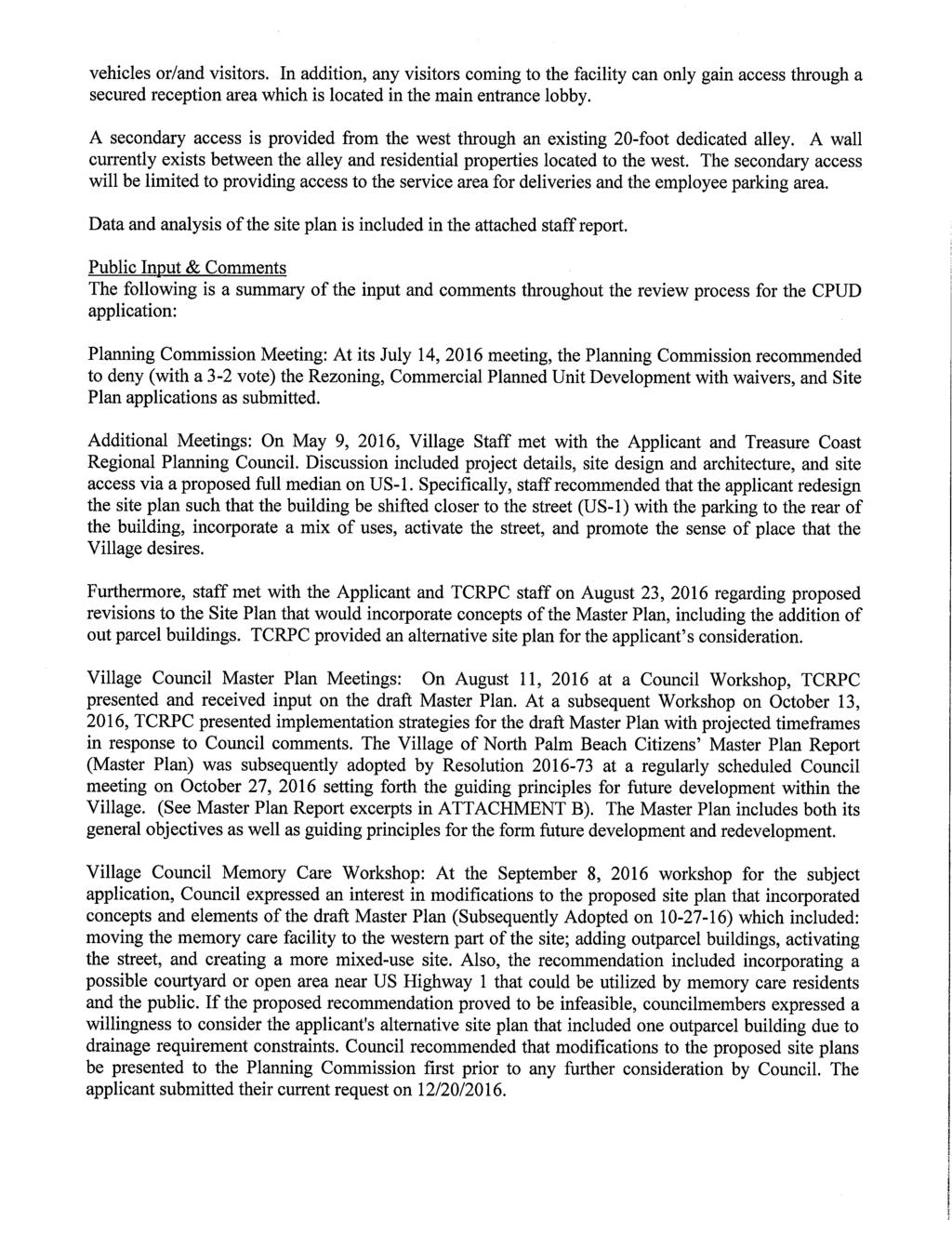
6 square foot Mixed-Use Assisted Living Facility with 60 rooms/72 beds and a one (1) story commercial building (restaurant/retail/office) up to 6,000 sf. The site is located on the west side of US-1, between Lighthouse Drive and Ebbtide Drive, approximately.5 miles north of Northlake Boulevard. (See ATTACHMENT A). The current Future Land Use (FLU) and current/proposed Zoning designations for the property are summarized in the table below: Exiting Future Land Use (FLU) Designation Existing Zoning Designation Proposed Zoning Designation Commercial CA Commercial C-1A Limited Commercial The following table summarizes the uses, FLU designations, and zoning districts of the subject parcels and surrounding properties: Existing Use FLU Zoning North Office Building Commercial CA Commercial East First Professional Office Commercial CA Commercial Building & Fetterman & Associates Law office South Atrium Condominium Commercial CA Commercial Office Building West Single-Family Residences separated by a public alleyway Low Density Residential fewer than 5.80 residential units per gross acre R-1 Single-Family Dwelling II. PUBLIC INPUT AND NOTICES: Development Review Committee (DRC): DRC 4/9/ The initial request, submitted in April 2016, was reviewed by the Development Review Committee (DRC) on April 9, DRC and subsequent staff comments were addressed with the exception of: (1) Village comment regarding the recommendation to redesign the site plan such that the building be shifted closer to the street (US-1) with the parking to the rear of the building, activating the street, and promoting the sense of place that the Village desires; and (2) Village comment regarding the need to receive FDOT and County approval for the proposed full median with left northbound turn lane and how it would align with the vision Village Master Plan and its implementation. In addition to and as a follow up to the outstanding DRC comments, on May 9, 2016, Village Staff met with the Applicant and Treasure Coast Regional Planning Council (TCRPC) staff. Discussion included project details, site design and architecture, and site access via a proposed full median on US-1. NPB Commons Memory Care Page 2
7 DRC 1/17/2017: The revised application, submitted December 20, 2016, was reviewed by the DRC on January 17, DRC and subsequent staff comments have been addressed with the exception of a Seacoast Utility Authority Concurrency Reservation Letter, or Developer s Agreement with SUA. Staff has proposed a condition of approval based on discussions with the applicant to address water/wastewater concurrency documentation. Village comments regarding the proposed full median with left northbound turn lane were not fully addressed in the revised application. Prior to any approvals of lane/median modifications and ROW permit, the Village will need to review compliance of the left northbound turn lane with the vision of the Village Master Plan and its implementation. Final applicable approvals from FDOT and PB County will be required. The applicant has received preliminary concept approval from FDOT for the left turn lane, which expired on March 10, The applicant will be required to update the letter prior to adoption. Applicant s Community Meeting: The applicant held an informational meeting for the community on April 27, 2016 to present the project and obtain public input. Public Notices: On May 27, 2016, courtesy notices were mailed to property owners within 500ft of the subject site and the sign was posted on the property. The legal ad was advertised in the Palm Beach Post on June 7, 2016 for the July 14, 2016 Planning Commission meeting. The legal ad was advertised in the Palm Beach Post on January 30, 2017 and courtesy notices were mailed to property owners within 500 feet on January 27, 2017 for the February 7, 2017 Planning Commission meeting. Courtesy notices were mailed on February 23, 2017 for the March 23, 2017 Village Council workshop meeting. Planning Commission Meeting: At its July 14, 2016 meeting, the Planning Commission recommended to deny (with a 3-2 vote) the Rezoning, Commercial Planned Unit Development with waivers, and Site Plan applications as submitted. Additional Meetings: On May 9, 2016, Village Staff met with the Applicant and Treasure Coast Regional Planning Council. Discussion included project details, site design and architecture, and site access via a proposed full median on US-1. Specifically, staff recommended that the applicant redesign the site plan such that the building be shifted closer to the street (US-1) with the parking to the rear of the building, incorporate a mix of uses, activate the street, and promote the sense of place that the Village desires. Additionally, staff recommended eliminating the proposed northbound left lane/median and utilizing the already existing left turn at Lighthouse Drive. Furthermore, staff met with the Applicant and TCRPC staff on August 23, 2016 regarding proposed revisions to the Site Plan that would incorporate concepts of the Master Plan, including the addition of out parcel buildings. TCRPC provided an alternative site plan for the applicant s consideration. Village Council Master Plan Meetings: On August 11, 2016 at a Council Workshop, TCRPC presented and received input on the draft Master Plan. At a subsequent Workshop on October 13, 2016, TCRPC presented implementation strategies for the draft Master Plan with projected timeframes in response to Council comments. The Village of North Palm Beach Citizens Master Plan Report (Master Plan) was subsequently adopted by Resolution at a regularly scheduled Council meeting on October 27, 2016 setting forth the guiding principles for future development within the Village. (See Master Plan Report excerpts in ATTACHMENT B). The Master Plan includes both its general objectives as well as guiding principles for the form future development and redevelopment. NPB Commons Memory Care Page 3
8 Village Council Memory Care Workshop: At the September 8, 2016 workshop for the subject application, Council expressed an interest in modifications to the proposed site plan that incorporated concepts and elements of the draft Master Plan (Subsequently Adopted on ) which included: moving the memory care facility to the western part of the site; adding outparcel buildings, activating the street, and creating a more mixed-use site. Also, the recommendation included incorporating a possible courtyard or open area near US Highway 1 that could be utilized by memory care residents and the public. If the proposed recommendation proved to be infeasible, councilmembers expressed a willingness to consider the applicant's alternative site plan that included one outparcel building due to drainage requirement constraints. Council recommended that modifications to the proposed site plans be presented to the Planning Commission first prior to any further consideration by Council. The applicant submitted their current request on 12/20/2016. Planning Commission Meeting: At its February 7, 2017 meeting, the Planning Commission recommended to deny (with a 3-2 vote) the Rezoning, Commercial Planned Unit Development with waivers, and Site Plan applications as submitted on January 27, Planning Commission comments included concerns about the parking and that the site plan had not changed enough subsequent to the last Planning Commission meeting, including consideration of a 2 story building. Planning Commission comments from dissenting members (who voted against the denial) included that too much focus was placed on the site as the primary location for the Village Center concept and support for the proposed use within the Village. Village Council 2 nd Memory Care Workshop: At the March 23, 2017 Workshop, Village Council discussion ensued regarding the proposed project components and the commercial component (Phase II) of the project. Discussion items by Council included: the project details, guiding principles desired by the Village and expressed in the Master Plan Report, the proposed use, site plan features, project layout and assurances that the commercial component (Phase II) would be constructed. Mr. Perry, property owner and applicant, responded to Council questions, including the commitment to build the commercial building. By consensus, the item was forwarded to first reading on April 13, The applicant submitted a revised request on February 27, 2017 prior to the March 23, 2017 Village Council Workshop. Specifically, the commercial building fronting on US Highway 1 was reduced by the applicant for consistency with the Village s Comprehensive Plan maximum building lot coverage of 35%. Also, the applicant included a phasing plan on the site plan and landscaping plan to show the required building and landscaping improvements for Phase 1. On March 31, 2017, the applicant submitted minor revisions to their request based on some of the comments from the Village Council Workshop, including updating the architectural drawings to reflect the revised renderings presented at the workshop. NPB Commons Memory Care Page 4
9 III. BACKGROUND AND ANALYSIS OF APPLICANT S REQUEST Parcel A: The subject property has been owned by 639 US Highway LLC since 2009 and is currently vacant. The property is approximately total acres with a Commercial Future Land Use (FLU) designation and CA Commercial Zoning Designation. In 2006, the long standing restaurant (known as DeCeasers, the Place for Ribs) was demolished and the property has remained vacant since. Parcel B: The subject has been owned by Commons at North Palm LLC since 2006 and is currently vacant. The property is approximately total acres with a Commercial Future Land Use (FLU) designation and CA Commercial Zoning Designation. The total gross acreage for the subject request is 2.72 acres. Applicant s Justification The applicant s justification states The demand for assisted living facilities throughout the United States is continuing to increase for a variety reasons. First and foremost, the so called baby boom generation (those born between 1946 and 1964) are aging and, according to the American Association of Retired Persons (AARP), will be turning 65 at a rate of 8,000 people a day between 2011 and Unfortunately, as these 52+ million people reach the age of needing care, alternatives to family caregivers will be necessary. (See ATTACHMENT A). Village Master Plan Report The Village of North Palm Beach Citizens Master Plan Report, adopted by Resolution on October 27, 2016, includes three (3) main objectives as well as many guiding principles for the form of future development and redevelopment. (See Master Plan Report excerpts in ATTACHMENT B). The goal of the effort was to determine a clear vision for the future to help guide decisions and investments by the Village. Three (3) clear objectives were identified: 1. Improve mobility, quality of life, and economic vitality of the Village; 2. Create a vision and Village Master Plan that illustrate strategies to achieve those objectives; and 3. Establish goals and policies to implement the Plan. In the Master Plan Report, the US 1 corridor was identified as a targeted redevelopment infill area where the guiding principles of infill redevelopment and a Village Center concept were recommended to be applied. The Report includes illustrations for infill project tests of the principles embedded in the community s vision and key to placemaking. They are intended to illustrate how the guiding principles could be applied to sites, although not limited to those sites nor to occur within a certain timeframe or exactly in the configuration shown. The key is to position the Village to accommodate growth in a form that will define and strengthen the Village s character. NPB Commons Memory Care Page 5
10 Guiding principles for future development and redevelopment along US Highway 1 include: Defined centers and gathering places for people; Buildings should be tall enough to enclose space; Buildings define the streets and open spaces; Mixed use buildings with lively, active uses along the sidewalks; Pedestrian routes to the center of a development should be shaded, clearly defined and as direct as possible; Streets are public and interconnected to surrounding neighborhood; Vibrant mix of uses and higher density development line the streets; Parking is provided in the rear of the buildings and on-street; and Prominent central gathering places or civic greens. Comprehensive Plan Consistency - Future Land Use Element On April 9, 2015, the Village Council approved a Comprehensive Plan Text Amendment to the Future Land Use Element (FLUE) pursuant to Ordinance No to allow Mixed-Use Assisted Living Facilities in Commercial Planned Unit Developments within the C-1A Limited Commercial District as follows: (Policies in bold are applicable to the application) FLUE Policy 1.B.3: Assisted Living Facilities, as defined in Section of the Florida Statutes and licensed by the Florida Agency for Health Care Administration may be permitted as mixed-use developments through the commercial planned unit development approval process subject to the following use and intensity standards: 1. Required uses: Each mixed-use Assisted Living Facility shall contain a residential component, together with a non-residential component consisting of administrative offices, central kitchen and communal dining facilities, and separate or shared spaces for the provision of medical, recreation, social, religious, and personal services. 2. Residential uses: The residential component shall consist of hallways, attendant stations, mechanical service rooms, and lounge areas, etc. within a designated residential wing of a mixed-use Assisted Living Facility. 3. Non-residential uses: The non-residential component shall be limited to providing goods and services to Assisted Living Facility residents, their visitors and facility staff. 4. Maximum floor area: The maximum mixed-use Assisted Living Facility development potential is subject to the floor-area limitations established in Policy 1.A.4, subject to the application of the Village s land development regulations. 5. Maximum resident occupancy: The residential density of a mixed-use Assisted Living Facility may be increased by the Village Council to an equivalent of 24 units per acre. The maximum resident occupancy shall then be determined by multiplying the equivalent residential density by 1.97 residents per unit. Maximum resident occupancy shall be determined on a project-by-project basis based upon an assessment of site characteristics and the application of Village land development regulations. NPB Commons Memory Care Page 6
11 6. Height limitations: The maximum height of a mixed-use Assisted Living Facility shall be determined by the application of Policy 1.B Waivers for reductions in minimum dwelling unit size and parking requirements may be requested during the commercial planned unit development approval process. Additional Comprehensive Plan FLU Element Policies applicable to the subject application are as follows: FLUE Policy 1.A.4: Land Development Regulations adopted and implement this Comprehensive Plan shall be based on and be consistent with the following standards for non-residential land use intensities as indicated below: a. Location shall be in accordance with the Future Land Use Map. Commercial uses shall not be permitted within areas designated for residential development on the Future Land Use Map Series; b. Maximum lot coverage ratio shall be 35%; c. Maximum building height shall be governed by district regulations in the Village Zoning Code and be based upon consistency with development trends in the vicinity and compatibility with neighboring non-commercial land uses; and d. Adequate off-street parking and loading facilities. e. Maximum Floor-Area-Ratios for non-residential land uses shall be established as follows: 1. Commercial land uses: A maximum of 0.35 along U.S. Highway 1, north of the Parker Bridge; a maximum of 1.10 along U.S. Highway No. 1, from the Parker Bridge, south to Northlake Boulevard; a maximum of 0.70 along U.S. Highway No. 1, south of Northlake Boulevard; and a maximum of 0.70 along Northlake Boulevard and S.R. Alternate A1A. The Twin City Mall site shall be exempt from this requirement, and subject to the Land Development Regulations of the C-3 Zoning District, which was jointly developed by the Village and the Town of Lake Park. 2. Public Buildings And Ground Uses: A maximum of Educational Uses: A maximum of 0.15; 4. Other Public Facilities Uses; A maximum of Recreation and Open Space Uses: A maximum of Light Industrial/Business Uses: A maximum of NPB Commons Memory Care Page 7
12 Policy 1.B.1: The following use and intensity standards shall be used to promote land use efficiency in infill and redevelopment activities, and determine maximum mixed-use development potential on a given parcel of land: 1. Maximum development potential: Maximum mixed-use development potential is subject to the floor-area limitations established in Policy 1.A.4, subject to the application of the Village s land development regulations. 2. Permitted uses: Each mixed-use development must contain a residential component, together with at least one non-residential component consisting of uses authorized in the assigned underlying commercial zoning district, subject to the conditions of approval. 3. Mix of uses: The non-residential component of a mixed-use development must comprise a minimum of 10% the gross floor area. The residential component of a mixed-use development must contain a minimum of 25% of the gross floor area. 4. Residential density: The residential component of a mixed-use development shall not exceed a density of 12 units per acre. 5. Height limitations: With the exception of those properties located along U.S. Highway 1, the maximum height of a mixed-use development shall be limited to that allowed by the underlying commercial zoning district. The maximum height for mixed-use developments with frontage U.S. Highway 1 is related to the depth of the property, as measured from the U.S. Highway 1 right-ofway, as follows: 250 feet or less: Maximum height of 2 stories. Greater than 250 feet to 300 feet: Maximum height of 3 stories Greater than 300 feet: Maximum height of 4 stories Staff Analysis - Comprehensive Plan Consistency The applicant meets the above FLU Element Policies for maximum floor area, maximum resident occupancy, height limitations, minimum dwelling unit size, and request for waivers as follows: Maximum Lot / Building Coverage: The maximum lot / building coverage is 35%; the applicant is proposing 36.5%. The applicant was requesting a waiver to the maximum floor area of 1.5% or approximately 1,828 sf to allow the proposed 6,000 sf commercial building. However, Comprehensive Plan provisions may not be waived. The applicant subsequently placed a note on the site plan effectively reducing the proposed square footage approximately 1,828 prior to the Village Council workshop, but is requesting a condition of approval to allow the additional 1,828 to be built should the Comprehensive Plan be amended in the future. Applicant s proposed condition: If the Village adopts a Comprehensive Plan amendment that increases the Lot/Building Coverage above 35%, the additional square footage (1,828 sf) depicted on the site plan may be constructed via the approval of a minor site plan amendment or a staff level review, if permitted. Staff is not seeking any changes to this provision at this time. NPB Commons Memory Care Page 8
13 Any revisions to these requirements would be part of the master plan implementation through Comprehensive Plan and Land Development Code revisions. Maximum Floor Area Ratio: The maximum floor area is 1.10 for commercial properties located along US Highway 1 south of Parker Bridge and north of Northlake Boulevard. The proposed FAR is or 43,404 sf, which is consistent with this policy.. Mix of uses: The non-residential component of a mixed-use development must comprise a minimum of 10% the gross floor area and a minimum of 25% gross floor area. The mix of uses on the proposed site plan is 10,938 non-residential uses or 29% percent and 26,466 of residential uses or 71%, which is consistent with the Plan policy. Maximum Resident Occupancy: The density calculations in terms of a unit (room) and resident (bed) are: Unit/Room Maximum Allowed: 24 units per ace Proposed: 60 rooms 2.72 acres = units per acre Resident/Bed Maximum Allowed: 24 units per acre X 1.97 residents per unit X 2.72 acres = 128 residential/beds total Proposed: 72 residents/beds Height Limitations: The maximum height limitation within the C-1A Limited Commercial District shall not exceed two (2) stories or thirty feet in height. The applicant is proposing one (1) story and a maximum height of 24 feet, which is consistent with the Plan policy. Rezoning On June 11, 2015, the Village Council approved an amendment (Ordinance No ) to Appendix C (Chapter 45), Zoning to adopt regulations, consistent with and to implement the Comprehensive Plan Text Amendment adopted in April 2015, to allow a Mixed-Use Assisted Living Facility if the property has a C-1A Limited Commercial Zoning District. It was determined that allowing for MUALFS only on those parcels with a C-1A Limited Commercial Zoning Designation at time of adoption was appropriate, and consistent with the desires and intent of the Village. The applicant is seeking to combine and rezone the subject properties totaling approximately 2.72 acres from a CA Commercial Zoning Designation to a C-1A Limited Commercial Zoning designation to allow for the Mixed-Use Assisted Living Facility (MUALF). (See ATTACHMENT B). The existing Commercial Future Land Use Designation on the subject properties only allows a MUALF if the property has a C-1A Limited Commercial Zoning Designation. The subject properties currently have a more intense CA Commercial Zoning Designation. Therefore, in order to construct a MUALF the applicant is requesting to rezone the subject properties to a more limited C-1A Limited Commercial Zoning Designation in order to locate the proposed use on the NPB Commons Memory Care Page 9
14 subject property. The proposed rezoning would lessen the number of uses currently allowed on site and as allowed in surrounding properties in the US Hwy 1 corridor. Uses permitted in the C- 1A Limited Commercial Zoning District include: hotels and motels, restaurants, nursery and private schools, golf clubs, professional offices, marinas and their accessory uses, multiplefamily, and assisted living facilities. Staff has concerns with rezoning the subject parcels to a more restrictive zoning district, which could potentially limit future uses and development opportunities, and economic vitality for the subject parcel and corridor. The Comprehensive Plan, Zoning Map, and Ordinances provide for a vision of the desired location for intensity and uses in the Village s commercial corridors. In the case of the subject rezoning, it would introduce C-1A Zoning District into a corridor of C-A Zoning. Rezoning to a C-1A Limited Commercial Zoning District would limit the number of allowable uses and would prohibit personal service, general retail and auditorium uses on the subject site as these uses are not permitted in the C-1A Zoning District. Further, the nature of the uses in the more limited C-1A Zoning District are most appropriate for the area in and around the vicinity of higher density residential and waterfront, like the North Palm Beach Yacht Club and Marina, where the District has been primarily applied. The permitted uses in C-1A Limited Commercial Zoning District are limited to: hotels and motels, restaurants, nursery and private schools, golf clubs, professional offices, marinas and their accessory uses, multiple-family, and assisted living facilities. The general area around the Marina is primarily built out with multi-family residential and marina. The uses in the C- 1A District compliment the residential and marine uses in that area. Additionally, restricting the subject site to a zoning district with more limited commercial uses is not consistent with the future vision of the US Highway 1 corridor and objectives of the Village s Master Plan Report, which is to create a sense of place and gathering, and improve mobility, quality of life and economic vitality. Staff has concerns that the proposed non-residential uses are limited to the one (1) commercial liner building (<6,000 sf) on the site that would not provide the same desired uses, street activation, and activity as with the current C-A Zoning that provides a broader range of commercial uses. Commercial Planned Unit Development (CPUD) with Waiver Requests The applicant submitted a CPUD application concurrently as part of the rezoning request. This facility will primarily be geared for the care of patients with Dementia and Alzheimer s disease commonly referred to as memory care. In order to facilitate the proposed MUALF, the applicant is requesting a total of four (4) waivers as described in the following table. (Waiver table on following page) NPB Commons Memory Care Page 10
15 Waivers Requested: Code Section Required Proposed Waiver Request Trees No trees to Modify required for be planted Spacing the north within the requirements buffer spaced north as presented at one (1) for landscape on the every 75 buffer proposed lineal feet of adjacent to Landscape landscape courtyard Plan for the buffer north and south property E D D One parking space for each residential living area of two (2) beds whichever is greater, plus one (1) parking space per 300 sf. of administrative and service area; 150 Required Six Feet (6 ) Max. Height 50 Front Setback 78 Parking Spaces Eight Feet (8 ) Max. Height 10 Front Setback lines. 72 Parking Spaces Two Feet (2 ) Applicant s Justification Trees adjacent to the outdoor courtyard creates safety and security issues as the residents are prone to climbing; Landscape planting areas are limited adjacent to courtyard fence and drainage lines; and No reduction of required trees is proposed as part of waiver. Residents cannot drive vehiclesreduces amount of parking required for use; and Maximum number of employees at peak work hour shift is 25 and it is common for employees to utilize public transportation options which reduces the parking required for the use. Increasing the fence height is necessary to ensure the safety of the residents utilizing outdoor courtyard. 40 Required to allow the placement of the commercial building in alignment with the adopted Village Master Plan concepts. NPB Commons Memory Care Page 11
16 Site Plan Applicant is proposing a one (1) story building totaling 37,404 square feet primarily intended for the care of patients with Dementia and Alzheimer s disease, commonly referred to as a memory care facility and one (1) story commercial building (restaurant/retail/office). The commercial building on the site plan will show a maximum of 6,000 sf with a note that only 4,172 sf may be built, unless a Comprehensive Plan amendment for Plan Policy 1.A.4 to allow for lot/building coverage greater than 35% is considered and adopted by the Village Council. The main access to the subject 2.72-acre property will be provided from the east with single ingress/egress points from/to US-1. The main access will provide access to the parking area and covered drop off area. In the applicant s justification, they indicate that sufficient parking and maneuvering areas have been designed for this area which meet the needs of emergency assistance vehicles or/and visitors. In addition, any visitors coming to the facility can only gain access through a secured reception area which is located in the main entrance lobby. APPLICABLE LAND DEVELOPMENT REGULATIONS Section Description Applicability 45-2 Definitions Assisted living facilities licensed by Applicant complies the agency for health care administration which provides housing, meals and personal care and services to adults for a period exceeding twenty-four (24) hours, as defined in s , F.S., as amended C1-A Limited commercial district Uses permitted Assisted living facilities subject to Policy 1.B.3 of the Future Land Use Element of the Village of North Palm Beach Comprehensive Plan and approved as a commercial planned unit development Applicant submitted applications for rezoning and planned unit development NPB Commons Memory Care Page 12
17 Section Description Applicability For assisted living facilities, a Applicant complies minimum of one (1) acre Each assisted living facility shall be Applicant is requesting a provided with one (1) parking space waiver for reduction of 11 measuring at least nine (9) feet by parking spaces* eighteen (18) feet (one hundred sixtytwo (162) square feet) for each residential living area or two (2) beds whichever is greater, plus one (1) parking space for each three hundred (300) square feet of administrative and service area within the building (kitchen, service halls, chapel, dining room, lounge, visiting areas and treatment rooms) C1-A Limited commercial district, Building height regulations, setbacks, building site area regulations commercial district off-street parking regulations In assisted living facilities, each residential living area containing one (1) bed shall have a minimum floor area of one hundred fifty (150) square feet. An additional one hundred (100) square feet of floor area shall be required for each additional bed provided within a separate living area. The maximum number of beds allowed in an assisted living facility shall be determined by multiplying the gross acreage of the site by beds per acre. No main building, however, shall occupy more than thirty-five (35) percent of the site area so required Applicant complies 128 residential/beds allowed 72 residential/beds proposed Refer to Applicant s revised justification statements dated April 21, 2016 SEE ATTACHMENT A Applicant Complies with Code Provision. However, Comprehensive Plan Policy 1.A.4 requires a max. 35% lot coverage. Applicant has modified their site plan to reduce the size by 1,828 sf from the proposed 6,000 sf of commercial building to comply. NPB Commons Memory Care Page 13
18 Section Description Applicability Yard space regulations. 1. Front yards. (a) For main structures of two (2) stories or less, there shall be a front yard of not less than fifty (50) feet measured from the street line to the front line of the main building. (b) For structures in excess of two (2) stories in height, the front yard depth required shall be controlled by the provisions defined in paragraph B of this section D. 1 Limited commercial district, Yard Space Regulations Planned unit development filing of application (D) Maximum Fence Height Six (6 ) All dwelling unit sizes, parking criteria and building site coverage must meet the requirements of the zoning code for each type of proposed use. Exception: applicants for assisted living facilities may, when accompanied by a justification statement, apply for a relief from the strict application of off-street parking regulations Six Feet (6 ) maximum height Applicant is requesting a waiver to reduce the front setback from the required 50 to 10 to accommodate the commercial building.* Applicant is requesting a waiver for reduction of 72 parking spaces. 150 Required and 78 are provided.* Applicant is requesting a waiver for the courtyard to increase the height by two (2) feet* One (1) tree provided for each seventy-five (75) lineal feet of landscape buffer or fractional part thereof adjacent to the north property line A total of five (5) trees provided (spaced) every 75 lineal feet of landscape buffer (360LF/75ft. O.C. = 5 trees) *Refer to Commercial Planned Unit Development Section Above Applicant is requesting a waiver to allow for reduction in tree spacing along the north and south property lines.* IV. INFRASTRUCTURE ANALYSIS IMPACT Drainage: Underground storm drainage piping and exfiltration trench are to be used to sufficiently address on-site drainage requirements. Outfall per the submitted drainage statement will be to the U.S. Highway 1 stormwater system. Preliminary Civil Plans and the Drainage Statement prepared by Simmons & White details the proposed drainage system which indicates that the Village meets Levels of Service for the 3-year frequency, 24 hour duration (one-day). (Attachment F) NPB Commons Memory Care Page 14
19 Traffic: On April 22, 2016, the Palm Beach County Department of Engineering and Public Works Traffic Engineering Division issued a letter indicating that the proposed development does not have significant peak hour traffic impact on the roadway network and therefore meets the Traffic Performance Standards of Palm Beach County. The applicant has submitted a revised concurrency application to the PBC Traffic Engineering Division, which includes 6,000 sf of commercial uses. According to the applicant, their application is under review. This letter was submitted on March 10, The applicant has proposed a left hand turn lane for the project, which has received preliminary concept approval from FDOT for the left turn lane. Prior to any approvals of lane/median modifications and ROW permit, the Village will need to review compliance of the left northbound turn lane with the vision of the Village Master Plan and its implementation. Final applicable approvals from FDOT and PB County will be required. The FDOT approval letter presented by the applicant expired on March 10, The applicant has been notified that this letter should be updated prior to 2 nd Reading. School Concurrency: Not Required there are no residential units being proposed. Water/Wastewater: The Seacoast Utility Authority (SUA) is the provider for water and waste water. The applicant has provided a letter from SUA dated 3/7/2106. The letter states that at the time the letter was issued, SUA had the additional capacity needed to meet the increase in demand generated by the proposed project. However, this letter does not reserve capacity for the proposed project and it is insufficient for concurrency purposes. In order to reserve SUA capacity to meet water and wastewater concurrency, SUA provides two options for a developer: (1) Enter into a developer agreement with the Authority for the intended use. Doing this requires them to pay 50% of connection fees (similar to impact fees) and 100 % of capacity reservation fees; or (2). Request a concurrency letter which requires a payment of 50% of capacity reservation fees but no connection fees. It reserves and commits Seacoast to provide capacity to the site. The applicant has proposed to modify the previous staff condition of requiring a concurrency letter prior to adoption hearing to instead enter into a developer s agreement prior to the boundary plat recordation or no later than 6 months after the approval of the development order, whichever occurs first. (Attachment F) Further, SUA has reviewed the proposed site plan, landscape plan and engineering drawings; and, has indicated that the existing and proposed water and wasterwater infrastructure and SUA s water and wastewater treatment capacity is adequate to serve this request. V. CONCLUSION: The applicant is requesting to rezone the subject parcels to the C-1A Zoning District as Mixed Use ALFs are permitted in the C-1A District, which necessitates a rezoning from C-A to C-1A to construct the proposed use. Staff has concerns with rezoning the subject parcels to a more restrictive zoning district, which could potentially limit future uses and development opportunities, and economic vitality for the subject parcel and corridor. The Comprehensive Plan, Zoning Map, and Ordinances provide for a vision of the desired location for intensity and uses in the Village s commercial corridors. In the case of the subject rezoning, it would introduce C-1A Zoning District into a corridor of C-A Zoning. Rezoning to a C-1A Limited Commercial Zoning District would limit the number of allowable uses and would prohibit personal service, general retail and auditorium uses on the subject NPB Commons Memory Care Page 15
20 site as these uses are not permitted in the C-1A Zoning District. Further, the nature of the uses in the more limited C-1A Zoning District are most appropriate for the area in and around the vicinity of higher density residential and waterfront, like the North Palm Beach Yacht Club and Marina, where the District has been primarily applied. The permitted uses in C-1A Limited Commercial Zoning District are limited to: hotels and motels, restaurants, nursery and private schools, golf clubs, professional offices, marinas and their accessory uses, multiple-family, and assisted living facilities. The general area around the Marina is primarily built out with multi-family residential and marina. The uses in the C-1A District compliment the residential and marine uses in that area. Additionally, restricting the subject site to a zoning district with more limited commercial uses is not consistent with the future vision of the US Highway 1 corridor and objectives of the Village s Master Plan Report, which are to create a sense of place and gathering, and improve mobility, quality of life and economic vitality. Staff has concerns that the proposed non-residential uses are limited to the one (1) commercial liner building (<6,000 sf) on the site that would not provide the same desired uses, street activation, and activity as with the current C-A Zoning that provides a broader range of commercial uses. Staff is recommending denial of the subject request. VI. VILLAGE COUNCIL ACTIONS A. Deny the subject request; or B. Approve the subject request (with no conditions); or C. Approve the subject request with the following conditions: 1. The Property shall be platted. Applicant shall provide the necessary draft boundary plat as a re-plat of the Property to address the combination of the parcels and include all easement/dedication language prior to the issuance of the first infrastructure permit. 2. Prior to the Village s issuance of any infrastructure permits or building permits, Applicant shall submit the following plans for review and approval by the Village: a. A mobilization plan and staging plan to the Fire Department, Police Department and Building Division; b. An updated Life Safety Plan, which shall comply with all applicable fire safety regulations and shall address all comments provided by Fire Department staff at the January 17, 2017 Development Review Committee meeting. c. An emergency evacuation plan filed with the Police Department and Fire Department. 3. Prior to any special events on the Property, Applicants shall be required to submit a parking plan with off-site parking, if required, with their special event permit application. 4. Prior to issuance of any infrastructure permits, Applicant shall provide the Village with a performance bond, letter of credit, escrow agreement or other acceptable surety agreement in a form and in an amount equal to 110% of the infrastructure improvements as approved by the Village to assure completion of on-site roadways, drainage and utility improvements. As improvements are completed and accepted by NPB Commons Memory Care Page 16
21 the Village, the amount of the performance bond, letter of credit, escrow agreement or other acceptable surety may be reduced by a proportionate amount as determined by the Village Engineer. 5. Any road closures or right-of-way improvements must obtain prior approvals and/or permits as required by the Village and/or other applicable authorities. 6. Prior to any permit approvals of lane/median modifications within the right-of-way, the Village shall review compliance of the left northbound turn lane with the vision of the Village Master Plan and its implementation. Final applicable approvals from the Florida Department of Transportation and Palm Beach County shall be required. 7. Applicants shall commence construction within eighteen (18) months from the effective date of this Ordinance, with the ability to request an administrative extension of no more than six (6) months if there is evidence that the development is progressing, or this Ordinance shall be automatically repealed by the Village Council. The Village will also initiate a rezoning of the Property back to the C-A Commercial Zoning District. 8. Applicant shall enter into a developer s agreement with Seacoast Utility Authority prior to the recordation of the boundary plat, or no later than six (6) months after the approval of this Ordinance, whichever occurs first. 9. Separate site improvement permits and applications shall be required for: (1) paving, grading, drainage, water and sewer improvements; (2) site lighting; (3) landscaping; and (4) irrigation. 10. Prior to the issuance of any Certificate of Occupancy, all roof top and ground mounted mechanical equipment shall be screened from view with materials approved by the Village. 11. Any newly installed utility services and service revisions shall be located underground. In granting this approval, the Village Council relied upon the oral and written representations of the Applicant both on the record and as part of this application process. 12. Any deviation from such representations shall be considered a violation of this Ordinance. 13. The Applicant shall construct all of the improvements identified in the plans and specifications listed in Section 3 above within eighteen (18) months of the effective date of this Ordinance. The Village Council may grant one additional six (6) month extension to this build-out date by resolution without the need to amend this Ordinance. NPB Commons Memory Care Page 17
22 14. Prior to scheduling Second Reading the applicant shall: a. Provide a rendering and a detailed cross section of the public gathering spaces and for the pergola area, including total open area and seating; b. Provide complete drawings and elevations depicting all architectural elements for all buildings that are consistent with the proposed site plan and landscape plans, or modify the site plan and landscape plans for consistency with the architectural drawings and rendering. c. Plans shall be internally consistent, depicting the public spaces and outdoor seating areas. VII. ATTACHMENTS ATTACHMENT A: Location Map & Legal Description Correspondence ATTACHMENT B: Village Master Plan ATTACHMENT C: Applicant s Justification Statement ATTACHMENT D: Rezoning Standards ATTACHMENT E: Correspondence ATTACHMENT F: Level of Service Letters ATTACHMENT G: Applicant s Revised Request Submitted March 31, 2017, including: Color Renderings & Architectural Drawings Proposed Site Plan Proposed Landscape Plan Proposed Master Sign Concept NPB Commons Memory Care Page 18
 parcels totaling 2.")
23 ATTACHMENT A: Ordinance Map & Legal Description Application No: North Palm Beach Commons Memory Care ( ) Location: Acres: 639 US Highway & Two (2) parcels totaling 2.72 acres Attachments - NPB Commons Memory Care Page 19
24 PCN: & LEGAL DESCRIPTION: THE NORTH 126 FEET OF THE SOUTH 730 FEET OF BLOCK 9, VILLAGE OF NORTH PALM BEACH PLAT NO. 1, ACCORDING TO THE MAP OR PLAT THEREOF AS RECORDED IN PLAT BOOK 24, PAGE(S) 202, PUBLIC RECORDS OF PALM BEACH COUNTY, FLORIDA. TOGETHER WITH: PARCEL 1: A PARCEL OF LAND IN BLOCK 9, VILLAGE OF NORTH PALM BEACH PLAT NO. 1, AS RECORDED IN PLAT BOOK 24, PAGE 202, PUBLIC RECORDS OF PALM BEACH COUNTY, FLORIDA, MORE PARTICULARLY DESCRIBED AS FOLLOWS: BEGINNING AT A POINT IN THE WESTERLY LINE OF SAID BLOCK 9, VILLAGE OF NORTH PALM BEACH, PLAT NO. 1, ACCORDING TO THE PLAT THEREOF, RECORDED IN PLAT BOOK 24, PAGES 202 TO 206, INCLUSIVE, PUBLIC RECORDS OF PALM BEACH COUNTY, FLORIDA, AT A DISTANCE OF 400 FEET NORTHERLY, MEASURED ALONG THE WESTERLY LINE OF SAID BLOCK 9, FROM THE SOUTHWESTERLY CORNER THEREOF; THENCE NORTHERLY ALONG THE WESTERLY LINE OF SAID BLOCK 9, A DISTANCE OF 100 FEET; THENCE EASTERLY PARALLEL TO THE SOUTHERLY LINE OF SAID BLOCK 9, A DISTANCE OF 360 FEET TO A POINT IN THE EASTERLY LINE THEREOF; THENCE SOUTHERLY ALONG THE EASTERLY LINE OF SAID BLOCK 9, IT BEING ALSO THE WESTERLY RIGHT-OF-WAY LINE OF STATE ROAD NO. 5 (U.S. HIGHWAY NO. 1), A DISTANCE OF 100 FEET; THENCE WESTERLY PARALLEL TO THE SOUTHERLY LINE OF SAID BLOCK 9, A DISTANCE OF 360 FEET TO THE POINT OF BEGINNING. PARCEL 2: A PARCEL OF LAND IN VILLAGE OF NORTH PALM BEACH PLAT NO. 1, AS RECORDED IN PLAT BOOK 24, PAGE 202, PUBLIC RECORDS OF PALM BEACH COUNTY, FLORIDA, MORE PARTICULARLY DESCRIBED AS FOLLOWS: BEGINNING AT A POINT IN THE LINE OF SAID BLOCK 9, VILLAGE OF NORTH PALM BEACH, PLAT NO. 1, ACCORDING TO THE PLAT THEREOF RECORDED IN PLAT BOOK 24, PAGES 202 TO 206, INCLUSIVE, PUBLIC RECORDS OF PALM BEACH COUNTY, FLORIDA, AT A DISTANCE OF 500 FEET NORTHERLY, MEASURED ALONG THE WESTERLY LINE OF SAID BLOCK 9, FROM THE SOUTHWESTERLY CORNER THEREOF; THENCE NORTHERLY ALONG THE WESTERLY LINE OF SAID BLOCK 9, A DISTANCE OF 100 FEET THENCE EASTERLY PARALLEL TO THE SOUTHERLY LINE OF SAID BLOCK 9, A DISTANCE OF 360 FEET TO A POINT IN THE EASTERLY LINE THEREOF; THENCE SOUTHERLY ALONG THE EASTERLY LINE OF SAID BLOCK 9, IT BEING ALSO THE WESTERLY RIGHT-OF-WAY LINE OF STATE ROAD NO. 5 (U.S. HIGHWAY NO. 1), A DISTANCE OF 100 FEET; THENCE WESTERLY PARALLEL TO THE SOUTHERLY LINE OF SAID BLOCK 9, A DISTANCE OF 360 FEET TO THE POINT OF BEGINNING. PARCEL3: A PARCEL OF LAND IN BLOCK 9, VILLAGE OF NORTH PALM BEACH PLAT NO. 1, AS RECORDED IN PLAT BOOK 24, PAGE 202, PUBLIC RECORDS OF PALM BEACH COUNTY, FLORIDA, MORE PARTICULARLY DESCRIBED AS FOLLOWS: BEGINNING AT A POINT IN THE WESTERLY LINE OF SAID BLOCK 9, VILLAGE OF NORTH PALM BEACH, PLAT NO. 1, ACCORDING TO THE PLAT THEREOF, RECORDED IN PLAT BOOK 24, PAGES 202 TO 206, INCLUSIVE, PUBLIC RECORDS OF PALM BEACH COUNTY, FLORIDA, AT A DISTANCE OF 600 FEET NORTHERLY, MEASURED ALONG THE WESTERLY LINE OF SAID BLOCK 9, FROM THE SOUTHWESTERLY CORNER THEREOF; THENCE NORTHERLY ALONG THE WESTERLY LINE OF SAID BLOCK 9, A DISTANCE OF 4 FEET; THENCE EASTERLY PARALLEL TO THE SOUTHERLY LINE OF SAID BLOCK 9, A DISTANCE OF 360 FEET TO A POINT IN THE EASTERLY LINE THEREOF; THENCE SOUTHERLY ALONG THE EASTERLYLINE OF SAID BLOCK 9, IT BEING ALSO THE WESTERLY RIGHT-OF-WAY LINE OF STATE ROAD NO. 5 (U.S. HIGHWAY NO. 1), A DISTANCE OF 4 FEET; THENCE WESTERLY PARALLEL TO THE SOUTHERLY LINE OF SAID BLOCK 9, A DISTANCE OF 360 FEET TO THE POINT OF BEGINNING. CONTAINING: ACRES Attachments - NPB Commons Memory Care Page 20

25 Attachment B: Master Plan Village Center Attachments - NPB Commons Memory Care Page 21

26 Attachments - NPB Commons Memory Care Page 22

27 Attachments - NPB Commons Memory Care Page 23

28 Attachments - NPB Commons Memory Care Page 24

29 ATTACHMENT C: Applicant s Justification Statement NORTH PALM BEACH COMMONS MEMORY CARE JUSTIFICATION STATEMENT Request(s): Applications for Rezoning, Planned Unit Development, Waivers & Site Plan Review Application Number: Project # MARCH 7, 2016-INITIAL SUBMITTAL APRIL 21, 2016-REVISED SUBMITTAL DECEMBER 20, 2016-REVISED SUBMITTAL JANUARY 26, 2017-REVISED SUBMITTAL FEBRUARY 27, 2017 VILLAGE COUNCIL PACKAGE PLANNING COMMISSION MEETING OF FEBRUARY 7, 2017 The majority of the revisions to the items in the justification statement and the site plan are a result of input received at the Planning Commission meeting, as well as staff identifying that the current Village Comprehensive Plan does not allow for lot coverage to exceed 35%, even though the FAR is permitted to be as high as 1.10 for this parcel. As such, the site plan has been revised to reflect that the square footage permitted to be constructed with this approval as 41,576 feet, in compliance with the current Comprehensive Plan limitation. This square footage is made up of the 37,404-square foot Assisted Living Facility building, and 4,172 square feet of a potential commercial building envisioned to be constructed at 6,000 square feet. It is the applicant s position that the existing 35% lot coverage limitation is somewhat inconsistent with the levels of potential intensity/density promoted by the Village s Master Plan and that staff initiated or applicant initiated amendments to the Plan will take place in the future to address this limitation. However, as the applicant has requested traffic approval from Palm Beach County for the total 6,000 square feet of commercial uses, the building remains in its current configuration on the Site Plan with notations that the square footage of the additional 1,828 will require a future approval by the Village prior to construction. Additionally, the waiver remains in place to be requested to the parking based on the ultimate potential construction of a 6,000-square foot commercial building. The other major change to the plan, based on comments at the Planning Commission, is that the applicant has elected to include the construction of the proposed pedestrian area/trellis system to the north of the entry drive within Phase 1 of the project. This will allow for the initial beginning of the creation of a more urban form along the US 1 Attachments - NPB Commons Memory Care Page 25
30 frontage, should the process of amending the Comprehensive plan delay the construction of the commercial building. OVERVIEW OF REQUESTS & PROPERTY INTRODUCTION On behalf of the applicant, NPB Senior Real Estate LLC, and the property owners, Commons at North Palm, LLC and 639 US Highway 1, LLC, Urban Design Kilday Studios (UDKS) has prepared and hereby respectfully submits these applications for the approval of a Rezoning, Planned Unit Development, Waivers & Site Plan Review requests. The subject 2.72-acre property is comprised of the following property control number s (PCN s) as assigned by the Property Appraiser of Palm Beach County: All of the land area described above is located within the municipal limits of the Village of North Palm Beach. The subject property is generally located on the west side of U. S. Highway 1 approximately.5 miles north of Northlake Boulevard. The subject property has a Future Land Use (FLU) designation of Commercial and is within the CA Commercial Zoning District. The applicant is requesting to rezone the subject property to C-1A Limited Commercial Zoning District to allow a Mixed Use Assisted Living Facility and commercial use(s). With the above applications, the applicant is requesting approval for a one (1) story 37,404 square foot Mixed-Use Assisted Living Facility with 60 rooms/72 beds and a one (1) story 6,000-square foot commercial building (restaurant/retail/office). The redesign is in response to input from both the Village Council and staff and proposes to provide additional entitlements to further the vison of the corridor per the master plan prepared by Treasure Coast Regional Planning Council. The potential uses will be discussed in greater detail later in this justification statement. The Mixed-Use Assisted Living Facility will primarily be geared for the care of patients with Dementia and Alzheimer s Disease commonly referred to as memory care. The demand for assisted living facilities throughout the United States is continuing to increase for a variety of reasons. First and foremost, the so called baby boom generation (those born between 1946 and 1964) are aging and, according to the American Association of Retired Persons (AARP), will be turning 65 at a rate of 8,000 people a day 1 between 2011 and Unfortunately, as these 52+ million people reach the age of needing care, alternatives to family caregivers will be necessary. According to an AARP report 2 issued in August 2013 the ratio of potential family caregivers to every person in the high-risk years of 80-plus will decline as follows: 2010: 7 to : 4 to : 3 to 1 Attachments - NPB Commons Memory Care Page 26
31 The ratio decline is significant as the period between 2030 and 2050 is when the majority of the baby boom generation will be in the high-risk years of 80-plus. As such, there will be a significant increase in demand for assisted living facilities as the ratio of potential family caregiver s decreases. In August of 2015, the Village of North Palm Beach engaged the Treasure Coast Regional Planning Council to develop a Master Plan for future/infill development and redevelopment in the Village. This resulted in a Master Plan being adopted by the Village Council in October The Village Master Plan identified this parcel and adjacent property as a future Village Center. The applicant has worked with the Village which has resulted in the revisions to the proposed project. At the request of the Village, the site has been redesigned and a 6,000-square foot commercial building (restaurant/retail) has been added to the proposed site plan in addition to the initial requested 37,404 square foot Mixed-Use Assisted Living Facility. Although the commercial building was included on the proposed site plan as requested, it is not a definite use. Retail uses and a restaurant or potentially even office uses, may be more appropriate for the site. Ultimately, the market will determine the uses for the future building as part of the leasing process and, as typical, tenants may change over time. Based on the Villages acceptance of the Treasure Coast Regional Planning Council Master Plan, it is anticipated that the Village will be amending the Property Development Regulations in order to implement the vision for the corridor. In the future, when the uses are defined, the applicant will work through any required approval process in place at the time. As such, the project is proposed to be phased in order for the applicant to have users defined for the building before expending additional capital to actually construct the building and associated site improvements necessary to support the users. Notwithstanding this, however, the Applicant will be required to provide significant underground drainage infrastructure in advance to accommodate the proposed 6000 square foot commercial building. The proposed applications to support a Mixed-Use Assisted Living Facility and commercial building will provide a facility in the Village of North Palm Beach that will contribute towards meeting the demand for years to come. Below is a more detailed explanation on the applications included with this request: 1. Rezoning of the subject property from the CA-Commercial Zoning District to the C-1A limited commercial Zoning District; 2. Approval of a Commercial Planned Unit Development (PUD); 3. Waiver to request a reduction of the required number of parking spaces from 150 parking spaces to 78 parking spaces; 4. Waiver to request increase fencing greater than 6 feet in height to a maximum of 8 feet in height; 5. Waiver to allow a reduction in tree spacing along the north and south property line; 6. Waiver from required front 50 feet setback to allow a 10-foot setback for the commercial building; 7. Site Plan Review (see attached Site Plan for details). Attachments - NPB Commons Memory Care Page 27
32 SURROUNDING USES Below is a description of the uses on the adjacent properties (or those on the other side of abutting R-O-W s) to the north, south, east and west of the subject property. Note that the acreages and ownership information referenced in this section is per information obtained from the Property Appraiser of Palm Beach County s web site. North: To the north of the subject property is one (1) property (details below): o PCN : This acre property is currently owned by Alfred Webb Investment Properties LLC and is within the municipal limits of the Village of NPB. This property has a FLU designation of Commercial and is within the Village s CA-Commercial Zoning District; South: To the south of the subject property is one (1) property (details below): o PCN : This 1.65-acre property is currently the 631 Atrium Condominium 401 LLC condominium office building and is within the municipal limits of the Village of NPB. This property has a FLU designation of Commercial and is within the Village s CA-Commercial Zoning District; East: To the east of the subject property are three (3) properties (details below): o PCN : This.7716-acre property is currently owned by 3 KAS Partners, LLC and is within the municipal limits of the Village of NPB. This property has a FLU designation of Commercial and is within the Village s CA-Commercial Zoning District; o PCN : This.8581-acre property is currently owned by 630 NPB LLC and is within the municipal limits of the Village of NPB. This property has a FLU designation of Commercial and is within the Village s CA-Commercial Zoning District; o PCN : This.99-acre property is currently the 1 st Professional Building condominium office building and is within the municipal limits of the Village of NPB. This property has a FLU designation of Commercial and is within the Village s CA-Commercial Zoning District; West: To the west of the subject property are five (5) properties (details below): o PCN : This.21-acre property is currently owned by the Theodore D. Wise and is within the municipal limits of the of the Village of NPB. This property has a FLU designation of Low Density Residential and is within the Village s R1-Single Family Dwelling Zoning District; o PCN : This.21-acre property is currently owned by the Michael S. Holzum Jr. and is within the municipal limits of the of the Village of NPB. This property has a FLU designation of Low Density Residential and is within the Village s R1-Single Family Dwelling Zoning District; Attachments - NPB Commons Memory Care Page 28
33 o PCN : This.21-acre property is currently owned by the Terrance N. & Kimberly H. Freeman. and is within the municipal limits of the of the Village of NPB. This property has a FLU designation of Low Density Residential and is within the Village s R1-Single Family Dwelling Zoning District; o PCN : This.21-acre property is currently owned by the Carl A. & Scott P. Simanski and is within the municipal limits of the of the Village of NPB. This property has a FLU designation of Low Density Residential and is within the Village s R1-Single Family Dwelling Zoning District; o PCN : This.21-acre property is currently owned by the Mathew T. Smith and is within the municipal limits of the of the Village of NPB. This property has a FLU designation of Low Density Residential and is within the Village s R1-Single Family Dwelling Zoning District; Mixed-Use Assisted Living Facilities DENSITY On April 9, 2015, the Village Council approved a Comprehensive Plan Text Amendment pursuant to Ordinance No to allow a Mixed-Use Assisted Living Facilities in Commercial PUD s within the C-1A Limited Commercial District. Known as Amendment 14-1, the Comprehensive Plan Text Amendment allowed a residential density up to an equivalent of 24 units per acre (with 1.97 residents per unit). The applicant is requesting approval of the above applications to allow a Mixed-Use Assisted Living Facility (ALF) with 60 rooms or units/72 beds on the 2.72-acre subject property. As such, below are the density calculations from both a unit (aka room) and resident (aka bed) perspective: Unit/Room o Maximum Allowed: 24 units per acre o Proposed: 60 rooms 2.72 acres = units per acre Resident/Bed o Maximum Allowed: 24 units per acre X 1.97 residents per unit X 2.72 acres = 128 residents/beds total o Proposed: 72 residents/beds As shown above, the proposed density is in conformance with the Comprehensive Plan Text Amendment approved and adopted by the Village Council on April 9, 2015, via Ordinance No As indicated previously, the intensity associated with the proposed commercial building is separate from the density permissible for the ALF. Attachments - NPB Commons Memory Care Page 29
34 CONCURRENCY Included with this application are the following documents related to the impact of the proposed project on public facilities: Drainage: Please see enclosed Preliminary Civil Plans and Drainage Statement prepared by Simmons & White in which the details of the proposed drainage system are provided. Please note that extensive review of the design options necessary to support the proposed development has been undertaken by the project engineer. In order to allow for the urban intensities promoted by the Master Plan that have resulted in the proposed development program, drainage design has been required to utilize non-typical design options, including but not limited to outfall into two separate drainage systems, the alley to the west and US1 to the east. Sheet flow to the Alley drainage system is proposed for discharge runoff from the westerly portion of the site. Sheet flow to the FDOT US1 right-of-way is proposed for discharge of the easterly portion of the site. The project is not anticipated to have any adverse effects on existing drainage patterns and established levels or service. Traffic: A revised Insignificant Traffic Impact Statement prepared by Simmons and White has been included with this submittal and will be provided to the Palm Beach County Traffic Division for review compliance with the Traffic Performance Standards (TPS). The square footage associated with the commercial building, as discussed with Village staff, has been analyzed based on the use of a high turn-over sit down restaurant. This generation rate was selected as it is the most intense from a traffic standpoint that most likely would ever utilize the space. It is the applicant s intent that, once the initial use(s) for the building are defined, a traffic equivalency statement would be prepared for approval and submittal to the Village prior to any permits and/or business tax receipts being issued by the Village. The TPS approval letter will be submitted to the Village when issued by Palm Beach County. Water/Wastewater: Please see enclosed Preliminary Civil Plans prepared by Simmons & White in which the details of the proposed water/wastewater system are provided. A service letter has also been requested from Seacoast Utilities. SITE DESIGN At the request of the Village, the site has been redesigned to include a 6,000-square foot restaurant in addition to the initial requested 37,404 square foot Mixed-Use Assisted Living Facility. Although the commercial building (restaurant) was included on the proposed site plan as requested, it is not a definite use. Retail uses, or potentially even office uses, may be more appropriate for the site. Ultimately, the market will determine the uses for the building. Typically, in form based codes which promote a more urban form of development such as that envisioned by the Village s Master Plan, the uses within the building are not as of much concern as the form of development. The design proposed strives to create the urban environment desired by the Village and create a pleasant experience for the pedestrian. Attachments - NPB Commons Memory Care Page 30
35 Based on the Villages acceptance of the Treasure Coast Regional Planning Council Master Plan, it is anticipated that the Village will be amending the Property Development Regulations in order to implement the vision for the corridor. In the future, when the uses are defined, the applicant will work through any required approval process in place at the time. The site plan will be developed in two (2) phases with the Mixed-Use Assisted Living Facility and associated parking planned for Phase I of the development and the commercial building in Phase II. Phase 1 will include the pedestrian amenity which includes the proposed trellis and parking screening wall to obstruct the view of the parking area for the commercial parking area and not only the infrastructure necessary to support the ALF, but also additional drainage infrastructure will be installed with Phase I in above and beyond what would be required for the ALF to support the Phase II commercial development portion of the development. This additional infrastructure equates to approximately $250, in development costs that will be expended up front, in anticipation of the future construction of Phase II. Phase II will include the commercial building and associated parking. Phase II will be developed in the future when user(s) have been identified. The site plan and landscape plan included with this submittal reflects the phasing of the project. Waivers have also been requested and will be discussed later in this statement. The main access to the 2.72-acre property will be provided from the east via a single ingress/egress points from/to U. S. Highway 1 (a R-O-W with an ultimate width of 120 feet). The main access will provide access to the shared parking area and also includes a covered drop off area provided specifically for the Mixed-Use Assisted Living Facility. It is anticipated that any emergency assistance called to the site or patrons/ visitors will locate and access the site via US Highway 1. Sufficient parking and maneuvering areas have been designed for this area which meet the needs of emergency assistance vehicles, patrons or/and visitors. In addition, any visitors coming to the Mixed-Use Assisted Living Facility can only gain access through a secured reception area which is located in the main entrance lobby. A secondary access is provided for the Mixed-Use Assisted Living Facility from the west through an existing 20-foot dedicated alley (per the Village of North Palm Beach Plat No. 1 as recorded in Plat Book 24, page ). Please note that in order to address neighbor concerns, the developer is willing to commit that night shift employees will utilize the east parking area only. A wall currently exists between the alley and residential properties located to the west. The secondary access will be limited to allow access to the service areas, deliveries and restricted to employee parking for the Mixed- Use Assisted Living Facility. An outdoor courtyard located adjacent to the north property line is proposed for the Mixed-Use Assisted Living Facility. The courtyard will include an 8-foot privacy/security fence including lock gates for the residents. A waiver is requested to allow an increase in the height of the privacy/security fence and discussed later in this statement. A fountain and butterfly garden along with pathways and sitting areas are proposed within the outdoor courtyard. To foster the urban feel desired for the corridor, a 5-foot wall with trellis is provided adjacent to U. S. Hwy 1 on the north side of the main access drive, which will also serve Attachments - NPB Commons Memory Care Page 31
36 to provide screening for the future parking area for the commercial building. The wall, trellis and landscaping will be constructed in Phase I of the development. The future commercial pad including the parking area will be sodded and maintained until construction of Phase II. A Phase II landscape plan is included which provides temporary landscaping in this area. All drainage runoff will be directed to on-site exfiltration trench for water quality and attenuation. Legal positive outfall is proposed via discharge to the Florida Department of Transportation US Highway 1 drainage system and the alley to the west. Environmental Assessment The Village code defines environmentally sensitive lands and native upland vegetative communities that require preservation, protection, or mitigation. Because of the disturbed nature of the property due to previous development, depleted soils and subcanopy and groundcover dominated by exotic and nuisance species, the vegetative composition on this property is not considered to be that of an intact native plant community. However, the Village code requires native trees and other vegetation to be incorporated in to the site plan or relocated to the greatest extent practicable. The landscape plan included with this request includes the relocation of seven (7) cabbage palms. A Vegetation Removal Application will be sought in conjunction with any future building permit for the subject site. As the existing plant material, especially the oaks are substandard and in the projects Landscape Architect s professional opinion, a safety concern. All exotics will be removed. REVIEW STANDARDS Please see below the applicant s responses to the Villages Rezoning, PUD and Waiver Standards. REZONING REVIEW STANDARDS 1. All applications for rezoning and all applications to amend, supplement, modify or repeal the boundaries, districts, regulations or restrictions established by this chapter shall be done by application to the planning commission of the village. The application to the planning commission may be made by any property owner or tenant or by a governmental office, department, board or bureau. Such applications shall be filed with the community development department of the village, which shall transmit the same, together with all the plans, specifications, applications and other papers pertaining to the application, to the planning commission. Any such application, except by a governmental agency, must be accompanied by a filing fee of one-thousand dollars ($1,000.00) together with a deposit of the estimated cost of the village processing the application. Upon the village determining the actual costs, applicants shall pay the balance, if any, in full of such costs including advertising prior to final consideration of the application. If the deposit exceeds actual costs, the balance shall be refunded to applicant. RESPONSE: This rezoning application is filed with the Community Development Department on behalf of the property owner and applicant. Furthermore, the applicant has submitted the necessary application fees. Attachments - NPB Commons Memory Care Page 32
37 2. All applications to the planning commission concerning rezoning shall be upon forms to be supplied by the community development department. RESPONSE: This rezoning application form completed and included with this request was provided to the agent by Village Staff. 3. Whenever, after review, investigation and hearing, any application for a change of district classification has been denied, an application for a like change cannot be reinstated for a period of at least one (1) year after said denial. RESPONSE: The applicant understands this provision and the request is compliant with this restriction. 4. Public notice of all hearings shall be provided as required by section 21-3 of the village Code. RESPONSE: The agent for the applicant is including one (1) copy each of the typed list and set of mailing labels for property owners within 500 feet of the property with this submittal. The agent/applicant understand that Village Staff will handle the actual public noticing. However, the applicant will draft property owners notice (under the Village planner s direction), mail notices and post the site at the appropriate time. PLANNED UNIT DEVELOPMENT REVIEW STANDARDS 1. All application and review procedures shall comply with section 21-12, Changes to zoning ordinances and section 45-49, Application for rezoning, of this Code. RESPONSE: The applicant is not requesting any changes to the code of ordinances. See descriptions above in the Rezoning Review Standards for compliance with Section A statement listing and fully explaining the specific modifications of the provisions of this chapter 45 which are desired, as well as the purposes for which the modifications are intended. RESPONSE: The applicant is not requesting any changes to the code of ordinances. Therefore, this sub-policy does not apply to the proposed request. 3. All application procedures for residential planned unit developments shall be as required by the subdivision provisions of this Code. RESPONSE: Not applicable for the proposed Commercial PUD. 4. Compliance with the village comprehensive plan is required. RESPONSE: The application is in compliance with Village comprehensive plan as provided below: Policy 1.A.4: This policy states that land development regulations shall be adopted to implement the Comprehensive Plan and shall be based on and be consistent with the following standards for non-residential land use intensities as indicated below: 1. Location shall be in accordance with the Future Land Use Map. Commercial uses shall not be permitted within areas designated for residential development on the Future Land Use Map Series. Response: The subject property is designated with a Commercial Land Use designation and is in compliance with this sub-policy. Attachments - NPB Commons Memory Care Page 33
38 2. Maximum lot coverage ratio shall be 35%; Response: As shown on the Site Plan prepared by the agent the proposed lot coverage is 36.5%. A waiver was initially requested to allow an increase in the maximum lot coverage from 35% to 36.5%. However, the maximum lot coverage is a provision of the Comprehensive Plan and may not be waivered. The initial proposal for the Mixed-Use Assisted Living Facility was in compliance with the maximum 35% allowable lot coverage. As previously discussed, the site has been redesigned as requested by the Village to include a 6,000-square foot commercial building (restaurant). The addition of building area makes it impossible to meet the maximum lot coverage of 35%. Based on the Villages acceptance of the Treasure Coast Regional Planning Council Master Plan, it is anticipated that the Village will be amending the Property Development Regulations in order to implement the vision for the corridor, which will need to address the building coverage limitations currently contained in the Code. In the future, when the uses are defined, the applicant will work through any required approval process at the same time. A condition of approval is proposed that provides If the Village adopts a Comprehensive Plan amendment that increases the Lot/Building Coverage above 35%, the additional square footage depicted on the site plan may be constructed via the approval of a minor site plan amendment or a staff level review, if permitted by the zoning code in place at the time". 3. Maximum building height shall be governed by district regulations in the Village Zoning Code and be based upon consistency with development trends in the vicinity and compatibility with neighboring non-commercial land uses; Response: Policy 1. B.1.7. provides that the maximum height of a mixeduse development shall be limited to that allowed by the underlying commercial zoning district. The maximum height for mixed use development with frontage along U.S. Highway 1 is related to the depth of the property, as measured from the U. S. Highway 1 right of way as follows: o 250 feet or less: Maximum height of 2 stores. o Greater than 250 feet to 300 feet; Maximum height of 3 stories. o Greater than 300 feet: Maximum height of 4 stories. Based on an existing lot depth of 360 feet from U. S. Highway 1, the subject property is limited to a maximum height of four (4) stories. However, the applicant is proposing a one-story 24-foot building 30 feet high Mixed-Use Assisted Living Facility. The proposed height does not require any increase to the district setbacks. The 6,000-square foot restaurant added to the proposed site plan will be reviewed in the future for compliance with the property development regulations. Based on the Villages acceptance of the Treasure Coast Regional Planning Council Master Plan, it is anticipated that the Village will be amending the Codes Property Development Regulations in order to implement the vision for the corridor. In the future, when the Attachments - NPB Commons Memory Care Page 34
39 uses are defined, the applicant will work through any required approval process at the same time. A will 4. Adequate off-street parking and loading facilities; Response: The applicant is requesting a waiver to reduce the amount of the required parking from 150 spaces to 78 spaces. A total of 66 parking spaces is required for the Mixed-Use Assisted Living Facility. The 6,000- square foot commercial building (restaurant) requires 84 parking spaces. total of 150 parking spaces are required by the Village code. A waiver of 72 parking spaces is requested to allow a total of 78 parking spaces for the proposed project. This is supportable specifically in regard to the type of facility being proposed, that being reducing the amount of parking required. Additionally, the waiver is compelled due to the addition of the 6,000-square foot commercial building (restaurant) as requested by the Village. Unfortunately, there is not sufficient space on the site to meet the parking requirements for the additional 6,000 square foot of commercial building area. Based on the Villages acceptance of the Treasure Coast Regional Planning Council Master Plan, it is anticipated that the Village be amending the Property Development Regulations in order to implement the vision for the corridor. In the future, when the uses are defined, the applicant will work through any required approval process at the same time. However, a waiver is required and requested which is further addressed in the waiver discussion herein. One (1) loading area is proposed in the rear (west elevation) of the building. A portico is proposed adjacent to the building s entry on the east elevation to provide drop off and pick up as needed along with an additional loading space on the eastern portion of the site in the main parking area. Policy 1.B.1: The following use and intensity standards shall be used to promote land use efficiency in infill and redevelopment activities and determine mixed-use development potential on a given parcel of land. 1. Maximum development potential: Maximum mixed-use development potential is subject to the floor-area limitations established in Policy 1. A.4. Response: The maximum floor area is limited to 35% as established in Policy 1. A.4. See response above to Policy 1. A Permitted Uses: Each mixed-use development must contain a residential component together with at least one non-residential component consisting of uses authorized in the assigned underlying commercial zoning district, subject to conditions of approval. Response: Assisted living facilities are authorized in a commercial planned unit development within the C-1A Limited Commercial zoning district. In addition to the residential units, the proposed facility contains non-residential components such as administrative offices, central kitchen, dining/activity rooms, salon, ice cream parlor, treatment rooms, etc. Additionally, a 6,000-square foot restaurant is allowed and has been added to the proposed site plan at the request of the Village. Although the restaurant is a permitted use, it is not a definite use. Based Attachments - NPB Commons Memory Care Page 35
40 on the Villages acceptance of the Treasure Coast Regional Planning Council Master Plan, it is anticipated that the Village will be amending the Codes Property Development Regulations in order to implement the vision for the corridor. In the future, when the uses are defined, the applicant will work through any required approval process at the same time. 3. Mix of uses: The non-residential component must compromise a minimum of 10% of the gross floor area and the residential component must compromise a minimum of 25% of the gross floor area. Response: The non-residential component is 10,938 s. f. (or 29% 37,404 s. f. facility) while the residential component is 26,466 s. f. (or 71% of the 37,404 s. f. facility). 4. Residential density: The residential component of a mixed-use development shall not exceed a density of 12 units per acre. Response: See response to density allowance under proposed Policy 1.B.3 below. 5. Height limitations: With the exception of those properties located along U.S. Highway 1, the maximum height of a mixed-use development shall be limited to that allowed by the underlying commercial zoning district. The maximum height for mixed use development with frontage along U.S. Highway 1 is related to the depth of the property, as measured from the U. S. Highway 1 right of way as follows: o 250 feet or less: Maximum height of 2 stores. o Greater than 250 feet to 300 feet; Maximum height of 3 stories. o Greater than 300 feet: Maximum height of 4 stores. Response: Based on an existing lot depth of 360 feet from U. S. Highway 1, the subject property is limited to a maximum height of four (4) stories. However, the applicant is proposing a one-story 24-foot building at a maximum of 30 feet in height. The proposed height does not require any increase to the district setbacks. Policy 1.B.3: Assisted living facilities, as defined in Section of the Florida Statues and licensed by the Florida Agency for Health Care Administration may be permitted as mixed-use developments through the commercial PUD approval process subject to the following use and intensity standards: 1. Required uses: Each Mixed Use Assisted Living Facility shall contain a residential component, together with a non-residential component consisting of administrative offices, central kitchen and communal dining facilities, and separate or shared spaces for provision of medical, recreational, social, religious, and personal services. Response: In addition to the residential units the proposed facility contains nonresidential components such as administrative offices, central kitchen, dining/activity rooms, salon, ice cream parlor, treatment rooms, etc. The residential component shall consist of residential units, hallways, attendant stations, mechanical service rooms, and lounge areas, etc. which are located Attachments - NPB Commons Memory Care Page 36
41 within a designated residential wing of a mixed-use Assisted Living Facility 2. Residential uses: The residential component shall consist of residential units, hallways, attendant stations, mechanical service rooms, and lounge areas etc. within a designated residential wing of mixed use assisted living Facility. Response: A total of 37,404 sf of gross floor area is proposed for the Assisted Living Facilities. The residential component includes residential rooms with bathrooms which are located within residential designated wings of the mixed use as well as the aforementioned uses. 3. Non-residential uses: The non-residential component shall be limited to providing goods and services to Assisted Living Facility residents, their visitors and facility staff. Response: Non-residential uses which provide goods and services to the residents include exam rooms, therapy rooms, ice crème parlor, general store, main kitchen and dining areas, salon, nurse stations, staff office etc. 4. Maximum floor area: Maximum Mixed Use Assisted Living Facility development potential is subject to the floor area limitations established in Policy 1. A.4. subject to the application of the Village s land development regulations. Response: The maximum floor area is limited to 35% as established in Policy 1. A.4. See response above to Policy 1. A.4. above. 5. Maximum resident occupancy: The residential density of a mixed use Assisted Living Facility may be increased by the Village Council to an equivalent of 24 units per acre. The maximum residential occupancy shall then be determined by multiplying the equivalent residential density by 1.97 residents per unit. Maximum resident occupancy shall be determined on a project by project basis based upon an assessment of site characteristics and the application of Village Land Development regulations. Response: As shown below, the proposed density is in conformance with the Comprehensive Plan Text Amendment approved and adopted by the Village Council on April 9, 2015, via Ordinance No Unit/Room Maximum Allowed: 24 units per acre Proposed: 60 rooms 2.72 acres = units per acre Resident/Bed Maximum Allowed: 24 units per acre X 1.97 residents per unit X 2.72 acres = 128 residents/beds total Proposed: 72 residents/beds 6. Height Limitations: The maximum height of a mixed use Assisted Living Facility shall be determined by the application of Policy 1. B.1.6. Response: Based on an existing lot depth of 360 feet along U. S. Highway 1, the subject property is limited to a maximum height of four (4) stories. However, the applicant is proposing a one-story 24-foot building at a maximum of 30 feet in Attachments - NPB Commons Memory Care Page 37
42 height. setbacks. The proposed height does not require any increase to the district 7. Waivers for reductions in minimum dwelling unit size and parking requirements may be requested during the commercial planned unit development approval process. Response: The current sizes of the proposed units meets the minimum of 50 square feet for single user units and 250 square feet for double occupancy units. Therefore, no waiver is requested for minimum dwelling unit sizes. The applicant is requesting a waiver to reduce the amount of the required parking from 150 spaces to 78 spaces. This is supportable specifically in regard to the type of facility being proposed, that being for memory care. Residents with memory care impairments do not drive vehicles, greatly reducing the amount of parking required. Additionally, the waiver is compelled due to the addition of the 6,000-square foot commercial building (restaurant) as requested by the Village. There is not sufficient space on the site to meet the parking requirements for the additional 6,000 square foot of commercial building area. Based on the Villages acceptance of the Treasure Coast Regional Planning Council Master Plan, it is anticipated that the Village will be amending the Property Development Regulations in order to implement the vision for the corridor. In the future, when the uses are defined, the applicant will work through any required approval process at the same time. 8. Land covered by the development plan shall be platted concurrently with final approval of the development plan. RESPONSE: The applicant understands this requirement. However, further discussions are anticipated in regard to the potential to unify the current land area via a unity of title rather than platting the property. 9. The fee for filing an application for a planned unit development shall be twothousand dollars ($2,000.00). RESPONSE: The applicant has submitted the necessary application fees. 10. The final approved development plan shall include the plat drawings and necessary submittals demonstrating acceptability of all factors and standards evaluated in subsection IV(A). RESPONSE: The applicant understands this requirement. However, further discussions are anticipated in regard to the potential to unify the current land area via a unity of title rather than platting the property. 11. All dwelling unit sizes, parking criteria and building site coverage must meet the requirements of the zoning code for each type of proposed use. RESPONSE: The applicant is requesting a waiver to reduce the amount of the required parking from 150 spaces to 78 spaces. This is supportable specifically in regard to the type of facility being proposed, that being for memory care. Residents with memory care impairments do not drive vehicles, greatly reducing the amount of parking required. Additionally, the applicant is indicating that the maximum number of employees at peak work hour shift is 25. It is also common for Attachments - NPB Commons Memory Care Page 38
43 the employees to utilize public transportation options. It should be noted that several Palm Tran bus stops are located along US. Highway 1 within close proximity to subject site (approximately 400 feet to the north and 300 feet to the south). A minimum of 30 parking spaces for visitor s use which is more than adequate to meet the parking needs for the proposed use. The current sizes of the proposed units meet the minimum of 150 square feet for single user units and 250 square feet for double occupancy units. Therefore, no waiver is requested for minimum dwelling unit sizes. However, the applicant is requesting a waiver to reduce the amount of the required parking from 150 spaces to 78 spaces. This is supportable specifically in regard to the type of facility being proposed, that being for memory care. Residents with memory care impairments do not drive vehicles, greatly reducing the amount of parking required. Additionally, the waiver is compelled due to the addition of the 6,000-square foot commercial building (restaurant) as requested by the Village. There is not sufficient space on the site to meet the parking requirements for the additional 6,000 square foot of commercial building area. Based on the Villages acceptance of the Treasure Coast Regional Planning Council Master Plan, it is anticipated that the Village will be amending the Property Development Regulations in order to implement the vision for the corridor. In the future, when the uses are defined, the applicant will work through any required approval process in place at the time. However, a waiver is required and requested. All land included for the purpose of development within a planned unit development shall be owned or under the unified control of the applicant for such zoning designation, whether the applicant is an individual, partnership, corporation, trust or group of individuals, partnerships, trusts or corporations. The applicant shall present satisfactory evidence of the unified control of the entire area by applicant within the proposed planned unit development and shall state agreement that, if he proceeds with the proposed development, he will: Do so in accordance with the officially approved development plan and such other conditions or modifications as may be attached to the conditional use. Provide agreements, covenants, contracts, deed restrictions or sureties acceptable to the village council, both for completion of the undertaking in accordance with the adopted development plan, and also for the continuing operation and maintenance of areas, functions and facilities which the plan shows are not to be operated or maintained at general public expense. Bind his development successors in title to any commitments made under subsections a. and b., preceding. RESPONSE: The acre property is currently owned by Commons at North Palm LLC, in part and 639 US Highway LLC, in part. NPB Senior Real Estate LLC (applicant) is under contract to purchase the full acre property. The site plan included with this request provides unified control of the entire area of the proposed development. Attachments - NPB Commons Memory Care Page 39
44 13. Any tract of land for which a planned unit development is made shall contain sufficient width, depth and frontage on a public dedicated arterial or major street or appropriate access which will accommodate the proposed use and design. RESPONSE: The subject property has a sufficient frontage and width of 330 feet along U.S. Highway 1 and a sufficient depth of 360 feet to accommodate the proposed design. 14. In the event, any building or structure built under this section is destroyed or removed by or for any cause, said building or structure, if replaced, shall be replaced with a building or structure of similar size and type not exceeding the dimensions of the original building or structure. The developer shall include the appropriate deed restrictions and/or covenants so as to require replacement as outlined above. RESPONSE: The applicant understands this provision. WAIVER JUSTIFICATION The following waivers are requested as part of this application: Waiver to request a reduction of the required number of parking spaces from 150 parking spaces to 78 parking spaces; Waiver to request increase fencing greater than 6 feet in height to a maximum of 8 feet in height; Waiver to allow a reduction in tree spacing along the north and south property line; Waiver from required front 50 feet setback to allow a 10-foot setback for restaurant building Parking Waiver The applicant is requesting a waiver to reduce the amount of the required parking from 150 spaces to 78 spaces. This is supportable specifically in regard to the type of facility being proposed, that being for memory care. Residents with memory care impairments do not drive vehicles, greatly reducing the amount of parking required. Additionally, the applicant is indicating that the maximum number of employees at peak work hour shift is 25. It is common for employees to utilize public transportation options. It should be noted that several Palm Tran bus stops are located along US. Highway 1 within close proximity to the subject site (approximately 400 feet to the north and 300 feet to the south). Based on the provision of 55 parking spaces, this provides a minimum of 30 parking spaces for visitor s use which is more than adequate to meet the parking needs for the proposed use. Additionally, the parking waiver is compelled due to the addition of the 6,000-square foot commercial building (restaurant) as requested by the Village. It is anticipated that the patrons will access the site by walking and biking as encouraged by the Village Master Plan further reducing the need for large amounts of parking on the subject site. There is not sufficient space on the site to meet the parking requirements for the additional 6,000 square foot of commercial building area. Based on the Villages acceptance of the Treasure Coast Regional Planning Council Master Plan, it is anticipated that the Village will be amending the Codes Property Development Regulations in order to implement the vision for the corridor. In the future, when the uses are defined, the applicant will work through any required approval process at the Attachments - NPB Commons Memory Care Page 40
45 same time. However, a waiver is required and requested to allow a reduction in the required parking for this site. Fence Height Waiver The applicant is also requesting a waiver to allow fencing greater than 6 feet in height. This fencing is being requested to secure the outdoor patio area due to the fact that residents of the facility may, from time to time, try to climb the fencing to leave the facility. As such, the eight (8) foot fence will provide the necessary security to ensure the safety of the residents. Tree Spacing Waiver The applicant is requesting a waiver from the minimum tree spacing along the north property line. The proposed landscape plan is in compliance with the quantity of trees required along the north and south buffer (360 LF/75 O.C). However, the trees are not able to meet the required 75 feet spacing due to the limited planting areas along the north and south boundary of the subject site. Regarding the north property line, a total of five (5) trees are required and are proposed spaced at intervals ranging from 14 to 142 lineal feet within the landscape buffer. An 8-foot privacy/security fence runs adjacent to the northern property line for a distance of approximately 93 feet before turning and attaching to the building on the east and west terminus to create an outdoor courtyard for the residents. A perimeter hedge is proposed on the outside of the fence while a butterfly garden with small tree specimens are located within the outdoor courtyard. Locating the larger trees in this area creates safety and security issues for the residents as it creates an attractive nuisance with the potential for the residents to utilize the trees to leave the supervision of staff. Additionally, there is limited space in which the trees can mature over the years when located adjacent to the proposed 8-foot privacy/security fence and several drainage lines are located in the area. Regarding the southern property line- A sewer line is proposed adjacent to the property line prevents trees from being located in the buffer area. A total of (5) trees are required and are proposed spaced at intervals ranging from 52 to 128 lineal feet adjacent to the south property line. A waiver is being requested for the spacing of the trees only. No reduction of planting material is requested. As required, a total of five (5) trees will be provided adjacent to both the north and south property line. Please refer to the landscape plan included in this submittal. Front Setback Waiver The applicant is requesting a waiver from the minimum front setback requirements. All setback is being met for the Mixed-Use Assisted Living Facility. However, a front setback waive is compelled due to the addition of the 6,000-square foot commercial building (restaurant) as requested by the Village. In order to meet the Master Plan s vision to create a more urban environment along the US 1 corridor, the project s design has placed the commercial building closer to the property line in this area. As such, the front setback is proposed at 10 feet rather that the code required 50 feet for the additional 6,000 square foot of commercial building area. Based on the Villages acceptance of the Treasure Coast Regional Planning Council Master Plan, it is anticipated that the Village will be amending the Codes Property Development Attachments - NPB Commons Memory Care Page 41
46 Regulations in order to implement the vision for the corridor. In the future, when the uses are defined, the applicant will work through any required approval process at the same time. However, a waiver is required and requested to allow a reduction of the front setback for this site. CONCLUSION In conclusion, it is the agent s position that the requested applications on the subject property are justified and are compatible with surrounding uses. Additionally, the proposed project is in compliance with the Villages code and ordinances. On behalf of the applicant and property owner, Urban Design Kilday Studios, respectfully requests approval of these requests. The Project Managers at Urban Design Kilday Studios are Joni Brinkman and Jan Polson who can be reached at (561) or via at jbrinkman@udkstudios.com or jpolson@udkstudios.com. Footnotes 1 Taken from 2 Report found at Attachments - NPB Commons Memory Care Page 42
47 ATTACHMENT D: Rezoning Standards In reviewing a proposed rezoning, Section of the Village s and Land Development Regulations requires that the Planning Commission shall consider all of the following: (1) All applications for rezoning and all applications to amend, supplement, modify or repeal the boundaries, districts, regulations or restrictions established by this chapter shall be done by application to the planning commission of the village. The application to the planning commission may be made by any property owner or tenant or by a governmental office, department, board or bureau. Such applications shall be filed with the community development department of the village, which shall transmit the same, together with all the plans, specifications, application blank and other papers pertaining to the application, to the planning commission. Any such application, except by a governmental agency, must be accompanied by the filing fee established in the master fee schedule adopted annually as part of the village budget together with a deposit of the estimated cost of the village processing the application. Upon the village determining the actual costs, applicants shall pay the balance, if any, in full of such costs including advertising prior to final consideration of the application. If the deposit exceeds actual costs, the balance shall be refunded to applicant. (2) All applications to the planning commission concerning rezoning shall be upon forms to be supplied by the community development department. (3) Whenever, after review, investigation and hearing, any application for a change of district classification has been denied, an application for a like change cannot be reinstated for a period of at least one (1) year after said denial. (4) Public notice of all hearings shall be provided as required by section 21-3 of the village Code. Attachments - NPB Commons Memory Care Page 43
48 Attachment E: Correspondence Attachments - NPB Commons Memory Care Page 44

49 Attachments - NPB Commons Memory Care Page 45
50 Attachments - NPB Commons Memory Care Page 46
51 From: Scott Simanski Sent: Friday, March 31, :26 AM To: council; Sita Erin Subject: NPB Commons Memory Care We have been thinking a lot about the property behind our property on Eastwind Drive since attending the Village Council Meeting last week. Many of the people that spoke were either current or former members of the Planning Committee and it sounded like a lot of them were in favor of the Master Plan over NPB Commons Memory Care Center. One current member of the Planning Committee was in very strong support of placing the memory care center on Prosperity Farms Road near Allamanda Elementary, where it was once proposed. That property seems like a much better fit since it does not really affect to much else besides a nature preserve. Backing a senior living facility up to a nature preserve sounds much more peaceful to the residents than next to a busy highway like US1. We do not see how a memory care facility would increase traffic in that area as was proposed by the residents who opposed it originally. The residents of Old Port Cove spoke in support of the memory care facility but I bet if this facility were proposed in their backyard, and was taking away their water view, they would have the same opposition that we have. The new proposal that we have in hand is nothing like what they proposed last year. We were sort of in support of that proposal and had a few conversations with Urban Design Kilday Attachments - NPB Commons Memory Care Page 47
52 Studios but eventually thought that a modified version of the Master Plan seemed to be a better fit for this property. We did let them know how we felt but none of that mattered since the proposal was voted down at that time. Now they are back trying again and we still think that something more interactive for all residents seems to be a better fit for this property. As we have stated previously, a road or new condos where our home currently stands is not really in our master plan. We love North Palm Beach and planned to eventually expand our home maybe adding a pool but want to make sure that you will preserve the neighborhood we enjoy so much. A "small town" development of restaurants and/or small local shops fronting US 1 with some green space behind to buffer the neighborhood sounds like a great idea for this property. This would be used by all residents and since this property is so central to the heart of North Palm it just makes sense. That is why the world renowned planner you hired put something like the Village Center on this property. The Village spent a lot of money on this Master Plan and it seems like building this memory care facility with an accessory phase 2 that incorporates a small bit of what the Master Plan calls for is a waste and not something I can support. My wife grew up two blocks away on Flotilla Road and her parents sill live there. Let's keep North Palm a community we all want to live in for the next generation and beyond. Frigates, Hogsnappers and the Village Square are all doing great. More places like these are what we need in this community, especially if you want to revitalize US 1. Eastwind Drive has gone through a transformation since we bought our home in We hope to live here for a long time and would love to see something done with the property behind our home that benefits everyone in the neighborhood. It sounds as though the people proposing the memory care facility are just adding the second building to try to appease the Village's wishes for implementing the Master Plan and it just doesn't seem right to us. They told us last year that they would do everything possible to minimize the impact to our properties on Eastwind Drive. Now that they have added Phase 2, the memory care facility is essentially moved into our backyard where it was once placed very close to US1 limiting the impact to our property. They have removed the screen of trees and shrubs that they had proposed between our home and the facility just to add an accessory building and more parking. We need to work with companies who care about the community we live in. It just seems like they are trying to force this proposal where ever they can and not considering the reason why a community like ours exists -- the residents that live here. This property has been vacant for many years and if you really want to try revitalize our community the owners can wait a little longer until we can come up with a solution that everyone can enjoy without causing a significant impact to current property owners living adjacent to the property Please let us know when the next meeting will be in regards to development of this property. We have a newborn at home so we are not sure we will attend but we would like you to share some of our thoughts with the other interested parties in the Village so they know how we feel about this issue in case we can't make it. We have already spoken to the neighbors on either side of our home and they have similar concerns about this issue. Thank you, Scott and Cari Simanski 624 Eastwind Drive Attachments - NPB Commons Memory Care Page 48
53 Attachment F: Level of Service Letters Attachments - NPB Commons Memory Care Page 49
54 Attachments - NPB Commons Memory Care Page 50
55 Attachments - NPB Commons Memory Care Page 51
56 Attachments - NPB Commons Memory Care Page 52

57 Attachments - NPB Commons Memory Care Page 53
58 Attachment G: Applicants Request - Revised Submittal March 31, 2017 Proposed Site Plan & Site Plan for Phase I Proposed Master Sign Concept Proposed Landscape Plan Proposed Civil Plan Conceptual Paving & Drainage and Water & Wastewater Architectural Drawings & Renderings Attachments - NPB Commons Memory Care Page 54

: EXISTING USE: PROPOSED USE(S):")
59 U. S. H I G H W A Y 1 LOCATION MAP: L I GHT HOUS E DR I V E SITE E B B T I D E D R I V E E A S T W I N D D R I V E Urban Planning & Design Landscape Architecture Communication Graphics ANCHORAGE DRIVE I N T R A C O A S T A L W A T E R W A Y 610 Clematis Street, Suite CU02 West Palm Beach, FL FAX #LCC WAIVERS REQUESTED: 1828 S.F. (1.5%) SUBJECT TO FUTURE COMPREHENSIVE PLAN AMENDMENT SEE NOTE 3. VINYL FENCE DETAIL: SPECIFIC MODEL AND DETAILS TO BE PROVIDED AT TIME OF BUILDING PERMIT APPLICATION. SITE DATA: APPLICATION NO: PROJECT NAME: EXISTING LAND USE: PROPOSED LAND USE: EXISTING ZONING DISTRICT: PROPOSED ZONING DISTRICT: SECTION/ TOWNSHIP/ RANGE: PCN (S): EXISTING USE: PROPOSED USE(S): NORTH PALM BEACH COMMONS MEMORY CARE COMMERCIAL COMMERCIAL CA - COMMERCIAL DISTRICT C-1A LIMITED COMMERCIAL DISTRICT COMMERCIAL PUD 16/42/ VACANT MIXED-USE ASSISTED LIVING FACILITY RESTAURANT/RETAIL/OFFICE ASSISTED LIVING FACILITY BUILDING CLASSIFICATION FOR FIRE CODE: I-2 TOTAL GROSS LOT AREA: 2.72 AC. (118,788 SF) GROSS FLOOR AREA ASSISTED LIVING: 37,404 SF A. RESIDENTIAL COMPONENT - 26,466 SF (71%) B. NON-RESIDENTIAL COMPONENT - 10,938 SF (29%) GROSS FLOOR AREA RESTAURANT/RETAIL/OFFICE: 6,000 SF PERVIOUS/IMPERVIOUS AREA: IMPERVIOUS: 1.64 AC. (71, SF) PERVIOUS: CONCURRENCY* 1.08 AC. (47, SF) USE: MIXED-USE ASSISTED LIVING FACILITY 37,404 SF (60 ROOMS/72 BEDS) HIGH TURN OVER SIT DOWN RESTAURANT 6,000 S.F. * CONCURRENCY IS APPROVED FOR THE ABOVE USES AND AMOUNTS SHOWN ON THIS PLAN. TRAFFIC ANALYSIS ZONE (TAZ): BUILDING COVERAGE ALLOWED (MAX. 35%): BUILDING COVERAGE PROPOSED: POTENTIAL BUILDING COVERAGE SUBJECT TO FUTURE AMENDMENT (36.5%) (SEE NOTE 3) 43,404 S.F. (+1,828 S.F.) MAX. BUILDING HEIGHT: 4 STORIES PROPOSED BUILDING HEIGHT : 1 STORY/24' (MAX. HT. 30') PARKING REQUIRED ASSISTED living: 66 SPACES USE : 1 SP. PER 60 UNITS = 60 SPACES USE : 1 SP. PER 300 SF ADMIN/SERVICE AREA@ 1,747 SF = 6 SPACES PHASE I PARKING PROVIDED: 55 SPACES PARKING REQUIRED RESTAURANT: 84 SPACES USE : 1 SP. PER 75 SF OF FLOOR AREA = 80 SPACES USE : 1 SP. PER 1.5 EMPLOYEES (6 EMPLOYEES) = 4 SPACES PHASE II PARKING REQUIRED: 150 SPACES PHASE II PARKING PROVIDED: 78 SPACES (WAIVER REQUESTED) 72 SPACES HANDICAP PARKING (SPACES INCLUDED IN TOTAL PARKING PROVIDED ABOVE) REQUIRED: 3 SPACES PROVIDED: 4 SPACES LOADING: PROVIDED: 2 SPACE SETBACKS NORTH 85 41,576 S.F. 41,576 S.F. Copyright: All ideas, designs, arrangements, and plans represented by this drawing are owned by and the property of the designer, and were created for the exclusive use of the specified project. These ideas, designs, arrangements or plans shall not be used by, or disclosed to any person, firm, or corporation without the written permission of the designer. North Palm Beach Commons Memory Care Village of North Palm Beach, Florida Conceptual Site Plan Waiver Code Section Requirement Proposed Waiver Justification* FRONT SIDE REAR 1. Section One (1) tree provided for each seventy-five (75) lineal feet of A total of Five (5) trees provided (spaced) every landscape buffer or fractional part thereof 75 lineal feet of adjacent to the south and north property lines. landscape buffer (360LF/ 75 ft. O.C.= 5 trees) D. 1. a. Front yards For main Commercial Building - structures of two (2) stories or less, there 50-foot front setback shall be a front yard setback of not less than fifty (50) foot feet measured from the street line to the front line of the main building E.7. (Assisted Living facility) One (1) Parking Space per for each residential living area or two (2) beds whichever is greater, plus one (1) parking space per 300 SF of administrative and service area E.6.- Restaurants, one (1) space for each seventy-five (75) square feet of floor area devoted to patron use, or one (1) space per three (3) fixed seats, whichever is greater, and one (1) space for each one and one-half (1-1/2) projected employees who would actually work during peak employment hours D Maximum Fence Height Six Feet (6 ) See justification statement for additional information 66 Parking Spaces 84 Parking Spaces (1 space per 75 SF & 1.5 space per employee) TOTAL REQUIRED 150 Parking Spaces A total of five (5) trees spaced ranging from 14 to 142 linear feet along the north buffer and 52 to 128 linear feet along the south buffer. Commercial Building- 10-footfront setback 55 Parking Spaces 23 parking spaces TOTAL PROVIDED 78 Parking Spaces Six Feet (6 ) Max. Ht. Eight Feet (8 ) Max. Ht. Trees spacing ranging from 14 to 142 linear feet along the north buffer and 52 to 128 linear feet along the south buffer. Front setback 10 feet (waiver of 40 feet) 1. Trees adjacent to outdoor courtyard creates safety and security issues as the residents are prone to climbing; 2. Landscape planting areas are limited adjacent to courtyard fence and drainage along north buffer and sewer along south buffer: 3. no reduction of required tree proposed as part of waiver 1. Setback Waiver for additional 6,000 square foot commercial building to support proposed Village Master Plan. Waiver required to comply with current code requirement. 72 parking spaces 1. Residents cannot drive vehicles-reduces amount of parking required for use. 2. Maximum number of employees at peak work hour shift is 25 and i t is common for employees to utilize public transportation options which reduces the parking required for the use. 2. Waiver for a dditional 6,000 square foot commercial building to support proposed Village Master Plan. Waiver required to comply with current code requirement. Two Feet (2 ) Increasing the fence height is necessary to ensure the safety of the residents utilizing outdoor courtyard. REQUIRED PROVIDED *SEE NOTE 3 DEVELOPMENT TEAM: SIMMONS & WHITE 5601 CORPORATE WAY SUITE 200 WEST PALM BEACH, FL (561) URBAN DESIGN KILDAY STUDIOS 610 CLEMATIS STREET SUITE CU02 WEST PALM BEACH, FL (561) NOTES 35% 50' 36.5%* NPB SENIOR REAL ESTATE LLC 1001 TELECOM DRIVE BOCA RATON, FL (561) ' GEOPOINT 4152 WEST BLUE HERON BLVD. SUITE 105 RIVIERA BEACH, FL (561) SITE PLAN BASED ON A SURVEY PREPARED BY GEOPOINT SURVEYING, INC., JANUARY 29, ALL UTILITIES TO BE UNDERGROUND SEC (G.). 3. IF VILLAGE ADOPTS A COMPREHENSIVE PLAN AMENDMENT THAT INCREASES THE LOT/BUILDING COVERAGE ABOVE 35%, THE ADDITIONAL SQUARE FOOTAGE DEPICTED ON THE SITE PLAN MAY BE CONSTRUCTED VIA THE APPROVAL OF A MINOR SITE PLAN AMENDMENT OR A STAFF LEVEL REVIEW, IF PERMITTED BY THE ZONING CODE IN PLACE AT THE TIME. 20' 13.3'/127.1' 10.1' / 16.2' 24' E&C ENGINEERS, INC VISTA PARKWAY SUITE 1-3 WEST PALM BEACH, FL (561) Date: 15' Scale: Project No.: Designed By: Drawn By: Checked By: NORTH Revision Dates: 30' 03/07/2016 Submittal 04/22/2016 Resubmittal 12/20/2016 Resubmittal 01/26/2017 Resubmittal 02/08/2017 Resubmittal 02/24/2017 Resubmittal SP-1 of 1 1" = 30'-0" 60' JWB JWB JP/JB/JWB # - IDENTIFIES EACH WAIVER LOCATION ON THE SITE PLAN
60 100.0' STORAGE 50.0' TAPER 0 28'37"E ' 16.3' COVERED ENTRY 1,191 SF (13'-6") CLEARANCE) TYPE 'D' CURB (TYP.) 18.0' 26.0' R25.0' R25.0' 12.0' 5.0' 7.3' 9.0' R25.0' 9.0' TYPE 'D' CURB (TYP.) 18.0' R25.0' FRONT SETBACK PAVEMENT SIGHT TRIANGLE (TYP.) MONUMENT SIGN R25.0' S9 31'23"E ' HANDICAP ACCESSIBLE ROUTE TO R.O.W. EXISTING SIDEWALK 13.3' SETBACK 120.0' 60.0' 60.0' EXISTING CURB CUT TO BE REMOVED TRELLIS SEATING AREA 5' PERIMETER WALL WITH DECORATIVE COLUMNS AND TRELLIS COVERING ENTIRE WALL NEW FP&L POWER POLE SIGHT TRIANGLE (TYP.) EXISTING CURB CUT TO BE REMOVED U.S. Highway 1 PROPOSED TURN LANE 100.0' STORAGE N80 28'37"E 16.3' COVERED ENTRY 18.0' 1,191 SF (13'-6") CLEARANCE) ' TYPE 'D' CURB (TYP.) R25.0' R25.0' 26.0' 18.0' 12.0' 5.0' 7.3' 9.0' R25.0' 9.0' TYPE 'D' CURB (TYP.) R25.0' FRONT SETBACK PHASE II LIMITS PAVEMENT PHASE II LIMITS PHASE I BAHIA SOD SIGHT TRIANGLE LN 1 (TYP.) MONUMENT SIGN PHASE I BAHIA SOD CHR2 16 CHR 45 JAS 246 LM 4 IXO 28 IXO 28 IXO 28 JAS 124 IXO 54 CLU 19 TRA2 6 IXO 79 JAS 279 CLU 19 CHR1 7 LN 1 TI1 7 S9 31'23"E ' TI1 6 HANDICAP ACCESSIBLE LM ' EXISTING SIDEWALK EXISTING CURB CUT TO BE SIGHT TRIANGLE 13.3' SETBACK ROUTE TO R.O.W. REMOVED TRELLIS SEATING AREA 5' PERIMETER WALL WITH DECORATIVE COLUMNS AND TRELLIS COVERING ENTIRE WALL NEW FP&L POWER POLE (TYP.) EXISTING CURB CUT TO BE REMOVED 120.0' U.S. Highway ' PROPOSED TURN LANE PLANT SCHEDULE * FLOWERING TREES CODE QTY BOTANICAL NAME / COMMON NAME LM 8 Lagerstroemia x `Muskogee` / Lavender Crape Myrtle Multi-Trunk 15` Ht., 6` Spr., 3" Cal. 5` Clear Trunk LN 2 Lagerstroemia x `Natchez` / White Crape Myrtle Min. 15` Ht. x 7` Spr., 5` Ct., 3.5" Cal. Total, Multi-Trunk, Full Canopy SHRUBS CODE QTY BOTANICAL NAME / COMMON NAME CHR 46 Chrysobalanus icaco `Red Tip` / Red Tip Cocoplum Min. 3 Gal. 24" Ht. x 24" Spr. 36" o.c.. Full and Dense Shrub, Full to Base CHR2 16 Chrysobalanus icaco `Red Tip` / Red Tip Cocoplum Min 7 gal. cont., 30" ht., 28" spr., full to base CHR1 7 Chrysobalanus icaco `Red Tip` / Red Tip Cocoplum Min. 3 Gal. 24" Ht. x 24" Spr. 24" o.c.. Full and Dense Shrub, Full to Base CLU 37 Clusia guttifera / Small-Leaf Clusia Min. 36" ht., 24" spr., 30" o.c. full to base shrub form ACCENT PLANTS CODE QTY BOTANICAL NAME / COMMON NAME TI1 13 Cordyline fruticosa `Red Sister` / Red Sister Ti Min. 7 Gal. Cont., 40" Ht., 24" Spr., 3 plants per pot VINE/ESPALIER CODE QTY BOTANICAL NAME / COMMON NAME TRA2 6 Trachelospermum jasminoides `Confederate` / Confederate Jasmine Min. 7 Gal. Cont., 5-7` Trellis Runners SHRUB AREAS CODE QTY BOTANICAL NAME / COMMON NAME IXO 216 Ixora coccinea `Maui` / Maui Ixora Min. 20" ht. 20" spr., 24" o.c., full to base shrub JAS 650 Jasminum volubile / Wax Jasmine Min. 3 Gal. Cont., 24" Ht., 18" Spr., Full, 2` o.c. Urban Planning & Design Landscape Architecture Communication Graphics 610 Clematis Street, Suite CU02 West Palm Beach, FL FAX #LCC Copyright: All ideas, designs, arrangements, and plans represented by this drawing are owned by and the property of the designer, and were created for the exclusive use of the specified project. These ideas, designs, arrangements or plans shall not be used by, or disclosed to any person, firm, or corporation without the written permission of the designer. North Palm Beach Commons Memory Care Village of North Palm Beach, Florida Phase I Site and Landscape Plans Drawing name: H:\JOBS\NPB Memory Care - US Hwy 1_16-001\Silver Fla Prop_DD_.000\Drawings\Site Plan\ Phase I SP.dwg 18.0' 26.0' 18.0' 12.0' TURN LANE 18.0' 26.0' 18.0' 12.0' TURN LANE 0 10' NORTH 20' 40' BICYCLE RACK ' ' BICYCLE RACK Date: Scale: Project No.: Designed By: Drawn By: Checked By: 1" = 20'-0" JWB JWB JP/JB/JWB Revision Dates: M 401 LLC 50.0' TAPER 631 ATRIUM CONDOMINIUM 401 LLC 03/07/2016 Submittal 04/22/2016 Resubmittal 12/20/2016 Resubmittal 02/23/2017 Resubmittal 03/31/2017 Revisions/ Trellis SP/LP-1 of 1

61 I N T R A C O A S T A L W A T E R W A Y U. S. H I G H W A Y 1 LOCATION MAP: L I GHT HOUSE DR I V E E A S T W I N D D R I V E SITE Urban Planning & Design Landscape Architecture Communication Graphics E B B T I D E D R I V E 610 Clematis Street, Suite CU02 West Palm Beach, FL FAX #LCC ANCHORAGE DRIVE NORTH Copyright: All ideas, designs, arrangements, and plans represented by this drawing are owned by and the property of the designer, and were created for the exclusive use of the specified project. These ideas, designs, arrangements or plans shall not be used by, or disclosed to any person firm, or corporation without the written permission of the designer S.F. (1.5%) SUBJECT TO FUTURE COMPREHENSIVE PLAN AMENDMENT SEE NOTE 3. GROUND SIGN 'A' EDWARDIAN SCRIPT ITC 12" HT TIMES NEW ROMAN 4" HT CONCEPTUAL SIGN DATA: MAXIMUM SIGN AREA 30 SF PROPOSED SIGN AREA SF MAXIMUM SIGN HEIGHT 8'-0" PROPOSED SIGN HEIGHT 6'-0" MINIMUM SIGN SETBACK 5'-0" PROPOSED SIGN SETBACK 13.3' MAXIMUM NUMBER OF SIGNS 1 SIGN PROPOSED NUMBER OF SIGNS 1 SIGN TEXTURED STUCCO FINISH, TYP. SIGN DETAILS: ALUMINUM SIGN PANEL WITH VINYL LETTERS & LOGO ADDRESS: PIN MOUNTED 6" NUMBERS BASE: TEXTURED STUCCO OVER BLOCK; PURE WHITE SW7005 (OR SIMILAR COLOR TO MATCH BUILDING) LANDSCAPE: 30" CONTINUOUS HEDGE AROUND SIGN BASE FONT: 12" EDWARDIAN SCRIPT ITC (OR EQUIVALENT) 4" TIMES NEW ROMAN North Palm Beach Commons Memory Care Village of North Palm Beach, Florida Master Signage Concept NOTE: FINAL COLORS AND NAME OF PROJECT WILL BE DETERMINED PRIOR TO BUILDING PERMIT APPLICATION SUBMITTAL SIGNAGE KEY MAP WALL SIGNS 'B' & 'C' ALL FUTURE WALL SIGNS FOR THE USES OF THE SITE SHALL COMPLY WITH SECTION (C) (2) PERMITTED ACCESSORY SIGNS OR AS AMENDED. 0 15' NORTH 30' 60' Scale: 1" = 30'-0" Date: Project No.: Designed By: Drawn By: Checked By: JWB JWB JP/JB/JWB Revision Dates: 02/24/2017 Resubmittal MS-1 of 1

62 PLANT SCHEDULE PHASE I TREES BACKFLOW PREVENTERS. PAVEMENT NORTH PALM BEACH VILLAGE OF PLAT 1 PB24 PG LI 2 PROPOSED 8' HT. PVC FENCE GATE PE SP 3 FLOWERING TREES PAVEMENT CODE QTY BOTANICAL NAME / COMMON NAME IP 2 Ilex x attenuata `East Palatka` / East Palatka Holly Min. 12` ht., 6` spr., 2" cal. 5` ct. QV 10 Quercus virginiana / Southern Live Oak Min. 15` Ht., 7` Spr., 4.5" Cal., 5` Ct., Matched QTY BOTANICAL NAME / COMMON NAME 9 Lagerstroemia indica `Dynamite` / Crape Myrtle Min.8` Ht. x 3-4` Spr., 3` Ct., 1" Cal., Total, 3-5 Multi-Trunks, Full Canopy, Matched LM 9 Lagerstroemia x `Muskogee` / Lavender Crape Myrtle Multi-Trunk 15` Ht., 6` Spr., 3" Cal. 5` Clear Trunk LN 13 Lagerstroemia x `Natchez` / White Crape Myrtle Min. 15` Ht. x 7` Spr., 5` Ct., 3.5" Cal. Total, Multi-Trunk, Full Canopy CODE QTY BOTANICAL NAME / COMMON NAME PS 2 Phoenix sylvestris / Wild Date Palm Min. 8` Clear Wood, 18" Cal., Matched PE3 10 Ptychosperma elegans / Alexander Palm 14` Clear Wood, 4" Cal., triple trunked palm PE2 1 Ptychosperma elegans / Alexander Palm 14` Clear Wood, 4" Cal., double trunked palm PE1 10 Ptychosperma elegans / Alexander Palm 14` Clear Wood, 4" Cal., single trunked palm SP 15 Sabal palmetto / Cabbage Palmetto 14" cal. slick trunks, hurricane-cut, hts. on plans are clear wood hts. CODE QTY BOTANICAL NAME / COMMON NAME CHR 163 CHR2 16 Chrysobalanus icaco `Red Tip` / Red Tip Cocoplum Min. 3 Gal. 24" Ht. x 24" Spr. 36" o.c.. Full and Dense Shrub, Full to Base Chrysobalanus icaco `Red Tip` / Red Tip Cocoplum Min 7 gal. cont., 30" ht., 28" spr., full to base CHR1 124 CLU4 11 CLU 78 Clusia guttifera / Small-Leaf Clusia Min. 36" ht., 24" spr., 30" o.c. full to base shrub form HAM 75 POD 86 Hamelia patens / Fire Bush Min. 3 Gal. 24" Ht. x 24" Spr. 36" O.C. Full and Dense Shrub, Full to Base Podocarpus macrophyllus / Yew Pine Min. 24" Ht., 20" Spr., Full to Base, Full Dense Shrub, 24" o.c. RE 8 Rhapis excelsa / Lady Palm Min. 7 Gal. Cont., 50" Ht., 36" Spr., 4` o.c., Full to base ZP 8 Zamia pumila / Coontie Min. 3 gal. cont., 20" ht., 20" spr., 30" o.c., full to base CODE QTY BOTANICAL NAME / COMMON NAME AO 4 Adenium obesum / Desert Rose Min. 3 Gal. Cont., 20" Ht. x 18" Spr., Red, Matched TI1 27 Cordyline fruticosa `Red Sister` / Red Sister Ti Min. 7 Gal. Cont., 40" Ht., 24" Spr., 3 plants per pot CRI 6 Crinum augustum `Queen Emma` / `Queen Emma` Crinum Min. 10 Gal. Cont., 4` Ht., 4` Spr., Disease free, 1 plant per pot SYZ 4 Syzygium paniculatum `Globulus` / Brush Cherry Min. 7 Gal. Cont., 3-4` Ht., Spiral, Matched CODE QTY BOTANICAL NAME / COMMON NAME TRA2 6 Trachelospermum jasminoides `Confederate` / Confederate Jasmine Min. 7 Gal. Cont., 5-7` Trellis Runners CODE QTY BOTANICAL NAME / COMMON NAME AC 58 Alocasia odora `California` / Dwarf Elephant Ear Min. 3 gal. cont., 18" ht. 18" spr., 24" o.c. ANN 162 Annuals Annuals / Annuals 4" pots, seasonal varieties, 1` o.c. AS 11 Asclepias curassavica / Blood Flower Min. 3 gal. cont., 18" ht., 16" spr.,24" o.c., full to base BUD 36 Buddleia davidii `Adokeep` / Adonis Blue Butterfly Bush Min. 3 gal. cont., 14" ht., 14" spr., 18" o.c. BA 21 Buddleia davidii `Adokeep` / Adonis Blue Butterfly Bush Min. 3 gal. cont., 14" ht., 14" spr., 18" o.c. CAF 39 Canna flaccida / Yellow Canna Min. 3 gal. cont., 18" ht., 16" spr., 24" o.c. COD 59 Codiaeum variegatum Mammey / Mammey Red Croton Min. 3 Gal. 16" Ht. x 16" Spr. 24" o.c., red leaves, Full and Dense Shrub, Full to Base DUR 125 Duranta erecta `Gold Mound` / Gold Mound Duranta Min. 3 gal. cont., 14" ht., 16" spr., full to base, 24" o.c. FGI 64 Ficus microcarpa `Green Island` / Green Island Ficus 18" ht., 18" spr., full to base, 18" o.c. HAN 68 Hamelia nodosa / Dwarf Firebush Min. 3 gal. cont., 20" ht., 20" spr., 30" o.c. ILX 178 Ilex vomitoria `Stokes Dwarf` / Dwarf Yaupon Min. 3 gal. cont., 12" ht., 12" spr., 18" o.c. IXO 285 Ixora coccinea `Maui` / Maui Ixora Min. 20" ht. 20" spr., 24" o.c., full to base shrub JAS 1,298 Jasminum volubile / Wax Jasmine Min. 3 Gal. Cont., 24" Ht., 18" Spr., Full, 2` o.c. LOR 94 Loropetalum chinense `Ruby` / Ruby Loropetalum Min. 3 gal. cont., 14" ht. 16" spr. 2` o.c. PTV2 108 Pittosporum tobira `Variegata` / Variegated Pittosporum 18" ht., 18" spr., full to base, 18" o.c. PTV1 111 Pittosporum tobira `Variegata` / Variegated Pittosporum Min. 3 gal. cont., 20" ht. 20" spr. full to base. 24" o.c. SAR 56 SAB 25 SAY 31 SCH 36 Salvia coccinea / Scarlet Sage Min. 3 Gal. Cont., 18" ht., 16" spr., Full to Base Salvia leucantha / Mexican Blue Sage Min. 3 Gal. Cont., 18" Ht., 16" Spr., 24" O.C. Full to Base Salvia madrensis / Sage Min. 3 Gal. Cont., 18" Ht., 16" Spr., 24" O.C. Full to Base Schefflera arboricola `Trinette` / Schefflera Min. 3 Gal. Cont., 18" Ht., 16" Spr. Full to base, 18" o.c. STA 68 CODE QTY TRM 1,128 X X X X X X X X X X X X X 4 LM 4 QV 2 DS DS FOUNTAIN TYP. BENCH TYP. 4 PHASE II LIMITS X EXISTING SIDEWALK LI 1 QV 4 DS DS TRA2 6 SHRUBS A/C UNITS TYP. IP 1 LN 4 DS 5' PERIMETER WALL WITH DECORATIVE COLUMNS AND TRELLIS COVERING ENTIRE WALL SIGHT TRIANGLE (TYP.) DS DS DS EXISTING FIRE HYDRANT TO REMAIN Drinking Fountains LN 2 DS MIXED-USE ASSISTED LIVING FACILITY 37,404 SF 1-STORY 60 ROOMS/72 BEDS BACKFLOW PREVENTERS. LN 4 COVERED ENTRY 1,191 SF (13'-6") CLEARANCE) 32 (33) PE (25) SIGHT TRIANGLE (TYP.) ACCENT PLANTS VINE/ESPALIER SHRUB AREAS PE3 2 PS 2 PHASE II LIMITS LI 4 GROUND SIGN DS DS PE DS DS DS GREASE TRAP ROOT BARRIER (TYP.) 17 (17) U.S. Highway 1 GENERATOR DS LI 1 PE1 4 12' x 35' LOADING AREA QV 3 LOADING EA IP 1 MA DS DS NE 12 UV ' x ER 35' IN G AR LN 2 TYPE 'D' CURB (TYP.) ST ER LI 1 DS DU MP QV 1 2 RESTAURANT RETAIL OFFICE 6,000 SF 1-STORY DS PE3 1 LM 4 LM 1 GREASETRAP TRAP GREASE PAVEMENT LAND USE DESIGNATION: COMMERCIAL ZONING DISTRICT: CA - COMMERCIAL DISTRICT LAND USE: COMMERCIAL OFFICE BLDG. PALM BEACH VILLAGE OF PLAT 1 PB 24 PG DS DS 1 ROOT BARRIER SYMBOL N.T.S. DS DS DS DS 4 3 BICYCLE RACK SP S.F. (1.5%) SUBJECT TO FUTURE COMPREHENSIVE PLAN AMENDMENT SEE NOTE Clematis Street, Suite CU02 West Palm Beach, FL FAX #LCC Copyright: All ideas, designs, arrangements, and plans represented by this drawing are owned by and the property of the designer, and were created for the exclusive use of the specified project. These ideas, designs, arrangements or plans shall not be used by, or disclosed to any person, firm, or corporation without the written permission of the designer. 14.3' LANDSCAPE BUFFER PE1 6 LN 1 Urban Planning & Design Landscape Architecture Communication Graphics PE3 1 GROUND COVERS Chrysobalanus icaco `Red Tip` / Red Tip Cocoplum Min. 3 Gal. 24" Ht. x 24" Spr. 24" o.c.. Full and Dense Shrub, Full to Base Clusia guttifera / Small-Leaf Clusia Min. 4` ht., 30" spr., 3` o.c., full to base shrub form NORTH 0 Scale: Stachytarpheta jamaicensis / Native Porter Min. 3 Gal. Cont., 18" Ht., 16" Spr., 24" O.C. Full to Base BOTANICAL NAME / COMMON NAME Trachelospermum asiaticum `Minima` / Minima Jasmine Min. 1 Gal. Cont., 8" Ht., 8" Spr., Full, 15" o.c. NOTE: - ALL SOD TO BE ST. AUGUSTINE FLORATAM SOD - ALL LANDSCAPE AREAS TO HAVE 100% AUTOMATIC IRRIGATION COVERAGE REQUIRED LANDSCAPING 20' 5 TREES 5 TREES 5 TREES 5 TREES 7 TREES 8 TREES 0 TREES 7 TREES 40' 1" = 20'-0" Date: Project No.: Designed By: JWB Drawn By: JWB Checked By: JP/JB/JWB Revision Dates: REQUIRED OFF-STREET PARKING AREA LANDSCAPE AREA (10 S.F. OF LANDSCAPE AREA FOR EACH PARKING SPACE EXCLUDING PARKING ABUTTING PERIMETERS - 68 SPACES) 680 S.F. PROVIDED OFF-STREET PARKING AREA LANDSCAPE AREA S.F. REQUIRED OTHER VEHICULAR USE AREAS LANDSCAPE AREA (1 S.F. OF LANDSCAPE AREA FOR EACH 100 S.F. OF PAVED AREA -32,861 S.F.EXCLUDING THE FIRST 5,000 S.F. - 27,861 S.F.) 236 S.F. PROVIDED OTHER VEHICULAR USE AREA LANDSCAPE AREA S.F. REQUIRED INTERIOR LANDSCAPE TREES (1 TREE FOR EACH 100 S.F. OF REQUIRED INTERIOR LANDSCAPE AREA S.F.) 10 TREES PROVIDED INTERIOR LANDSCAPE TREES 10 TREES MAXIMUM % OF PROVIDED PALMS 50% PROVIDED % OF PALMS (15 PALMS - 34 TREES) 30.6% REQUIRED BUFFER TREES NORTHERN BUFFER REQUIRED TREES (360 LF/ 75' O.C.) PROVIDED TREES SOUTHERN BUFFER REQUIRED TREES (360 LF/ 75' O.C.) PROVIDED TREES EASTERN BUFFER REQUIRED TREES (330 LF/ 50' O.C.) PROVIDED TREES WESTERN BUFFER REQUIRED TREES PROVIDED TREES 10' 03/07/ /22/ /20/ /26/ /24/ /31/2017 Submittal Resubmittal Resubmittal Resubmittal Resubmittal Revisions/ Trellis LP-1 of 1 Drawing name: H:\JOBS\NPB Memory Care - US Hwy 1_16-001\Silver Fla Prop_DD_.000\Drawings\Landscape Plan\ LP.dwg X DS 3 X 4 X DS DS DS X PALM TREES Village of North Palm Beach, Florida Phase II Landscape Plan DS DS DUMPSTER TYPE 'D' CURB (TYP.) North Palm Beach Commons Memory Care OUTDOOR COURTYARD X PLAT 1 PB24 PG X CODE LI
63 NOTES: 1. ALL TREES SHALL MEET FLORIDA #1 OR BETTER STANDARDS. 2. REMOVE ALL NON-ORGANIC BINDING AND SHIPPING MATERIAL FROM THE TREE AND ROOT BALL. 3. ANY PRUNING SHALL BE COMPLETED AT THE DIRECTION OF THE OWNER OR LANDSCAPE ARCHITECT. 4. NO NAILS SHALL BE DRIVEN INTO TREE AND TRUNK SHALL BE FREE OF ANY MAJOR SCARS. 5. ADD FERTILIZER AS DIRECTED IN WRITTEN SPECIFICATIONS. PLASTIC HOSE OR (2) PLY 3/4" RUBBER TUBE TO PROTECT TRUNK FROM GUY WIRE. TOP OF ROOT BALL SHALL SIT 2" ABOVE THE FINISHED GRADE. (ALLOW FOR SETTLING) MULCH TO MINIMUM DEPTH OF 3" AFTER SETTLING. MULCH SHOULD NOT BE IN DIRECT CONTACT WITH THE TRUNK. (SEE WRITTEN SPECIFICATIONS) ROOT BALLS GREATER THAN 2' IN DIAMETER SHALL SIT ON A MOUND OF UNDISTURBED SOIL TO PREVENT SETTLING. ROOT BALLS SMALLER THAN 2' IN DIAMETER MAY SIT ON COMPACTED EARTH. DIAMETER OF EXCAVATED HOLE SHALL BE AT LEAST TWICE THE WIDTH OF THE ORIGINAL ROOT BALL OR CONTAINER. (SEE WRITTEN SPECIFICATIONS) TREE PLANTING DETAIL NOT TO SCALE NOTES: 1. ALL TREES SHALL MEET FLORIDA #1 OR BETTER STANDARDS 2. REMOVE ALL NON-ORGANIC BINDING AND SHIPPING MATERIAL FROM THE TREE AND ROOT BALL. 3. ANY PRUNING SHALL BE COMPLETED AT THE DIRECTION OF THE OWNER OR LANDSCAPE ARCHITECT. 4. NO NAILS SHALL BE DRIVEN INTO TREE AND TRUNK SHALL BE FREE OF ANY MAJOR SCARS. 5. ADD FERTILIZER AS DIRECTED IN WRITTEN SPECIFICATIONS. MULCH TO MINIMUM DEPTH OF 3" AFTER SETTLING. MULCH SHOULD NOT BE IN DIRECT CONTACT WITH THE TRUNK. (SEE WRITTEN SPECIFICATIONS) 2" x 4" x 24" GUY WIRE STAKE MADE OF PRESSURE TREATED HARDWOOD DIAMETER OF EXCAVATED HOLE SHALL BE AT LEAST TWICE THE WIDTH OF THE ORIGINAL ROOT BALL OR CONTAINER. (SEE WRITTEN SPECIFICATIONS) IRREGULAR & MULTI-STEM TREE PLANTING DETAIL NOT TO SCALE 1x 2x 1x 2x # TREES SHALL BE PLANTED IN A VERTICAL POSITION AND ORIENTED TO GIVE THE BEST POSSIBLE APPEARANCE. DO NOT CUT OUT TERMINAL LEADER SELECTIVELY PRUNE TREE CROWN USE A PLUM LINE TO ASSURE THE TREE IS PROPERLY PLANTED UPRIGHT BEFORE BACKFILLING AND TAMPING. TREE CALIPER SHALL BE MEASURED 6" ABOVE GRADE FOR TREES UP TO 4" IN CALIPER AND MEASURED 12" ABOVE GRADE FOR TREES OVER 4" IN CALIPER. #12 GALVANIZED STEEL GUY WIRE WITH TURNBUCKLE AND CONSPICUOUS COLOR SAFETY FLAGS. CREATE A 6" HIGH CIRCULAR WATERING BASIN AROUND THE TREE BASE AT LEAST AS WIDE AS THE ROOT BALL IN DIAMETER. 2" x 4" x 24" GUY WIRE STAKE MADE OF PRESSURE TREATED HARDWOOD FINISHED GRADE TREE PLANTING PIT TO BE FULLY EXCAVATED AND BACKFILLED WITH TOPSOIL. TAMP FILL AS IT IS ADDED. WHEN HOLE IS 2/3 FILLED, WATER THOROUGHLY, RELEASE ANY AIR POCKETS, THEN COMPLETE FILLING. TAMP AND WATER THOROUGHLY AGAIN. (SEE WRITTEN SPECIFICATIONS) PLASTIC HOSE OR (2) PLY 3/4" RUBBER TUBE TO PROTECT TRUNK FROM GUY WIRE. TOP OF ROOT BALL SHALL SIT 2" ABOVE THE FINISHED GRADE. (ALLOW FOR SETTLING) #12 GALVANIZED STEEL GUY WIRE WITH TURNBUCKLE AND CONSPICUOUSLY COLORED SAFETY FLAGS. ROOT BALLS GREATER THAN 2' IN DIAMETER SHALL SIT ON A MOUND OF UNDISTURBED SOIL TO PREVENT SETTLING. ROOT BALLS SMALLER THAN 2' IN DIAMETER MAY SIT ON COMPACTED EARTH. CREATE A 6" HIGH CIRCULAR WATERING BASIN AROUND THE TREE BASE AT LEAST AS WIDE AS THE ROOT BALL IN DIAMETER. FINISHED GRADE TREE PLANTING PIT TO BE FULLY EXCAVATED AND BACKFILLED WITH TOPSOIL. TAMP FILL AS IT IS ADDED. WHEN HOLE IS 2/3 FILLED, WATER THOROUGHLY, RELEASE ANY AIR POCKETS, THEN COMPLETE FILLING. TAMP AND WATER THOROUGHLY AGAIN. (SEE WRITTEN SPECIFICATIONS) NOTES: 1. ALL SHRUBS SHALL MEET FLORIDA #1 GRADE OR BETTER STANDARDS. 2. REMOVE ALL NON-ORGANIC BINDING AND SHIPPING MATERIAL FROM THE SHRUB AND ROOT BALL. 3. ANY PRUNING SHALL BE COMPLETED AT THE DIRECTION OF THE OWNER OR LANDSCAPE ARCHITECT. 4. ADD FERTILIZER AS DIRECTED IN WRITTEN SPECIFICATIONS. TOP OF ROOT BALL SHALL SIT 1" ABOVE THE FINISHED GRADE. (ALLOW FOR SETTLING) ROOT BALLS GREATER THAN 2' IN DIAMETER SHALL SIT ON A MOUND OF UNDISTURBED SOIL TO PREVENT SETTLING. ROOT BALLS SMALLER THAN 2' IN DIAMETER MAY SIT ON COMPACTED EARTH. SHRUB PLANTING PIT TO BE FULLY EXCAVATED AND BACKFILLED WITH TOPSOIL. TAMP FILL AS IT IS ADDED. WHEN HOLE IS 2/3 FILLED, WATER THOROUGHLY, RELEASE ANY AIR POCKETS, THEN COMPLETE FILLING. TAMP AND WATER THOROUGHLY AGAIN. (SEE WRITTEN SPECIFICATIONS) LARGE SHRUB PLANTING DETAIL NOT TO SCALE NOTES: 1. MULCH RINGS SHALL BE PROVIDED FOR ALL TREES AND PALMS PLANTED IN SODDED AREAS OR AS OTHERWISE NOTED ON LANDSCAPE PLAN. MULCH RING IN SOD DETAIL NOT TO SCALE REMAINING SHRUBS ARE FILLED IN BEHIND THE FRONT SHRUB LINE. 1x 2x TREE OR PALM TRUNK SOD SHRUBS SHALL BE PLANTED IN A VERTICAL POSITION AND ORIENTED TO GIVE THE BEST POSSIBLE APPEARANCE MULCH TO MINIMUM DEPTH OF 3" AFTER SETTLING. MULCH SHOULD NOT BE IN DIRECT CONTACT WITH THE SHRUB BASE. (SEE WRITTEN SPECIFICATIONS) CREATE A 4" HIGH CIRCULAR WATERING BASIN AROUND THE SHRUB BASE AT LEAST AS WIDE AS THE ROOT BALL IN DIAMETER. FINISHED GRADE DIAMETER OF EXCAVATED HOLE SHALL BE AT LEAST TWICE THE WIDTH OF THE ORIGINAL ROOT BALL OR CONTAINER. (SEE WRITTEN SPECIFICATIONS) PLAN SYMBOL N.T.S. MULCH RING SHALL BE CUT INTO A 'PERFECT' CIRCLE'. EDGES TO BE WELL-FORMED AND CRISP WITH VERTICALLY STRAIGHT CUTS. MULCH RING SHALL MEASURE 5' IN DIAMETER OR EXTEND TO THE EDGE OF THE DRIP LINE, WHICHEVER IS GREATER. MULCH TO MINIMUM DEPTH OF 3" AFTER SETTLING. MULCH SHOULD NOT BE IN DIRECT CONTACT WITH THE TRUNK. (SEE WRITTEN SPECIFICATIONS) LAYOUT OF SHRUBS AT THE PLANTING EDGE IS DONE FIRST TO ESTABLISH A CONTINUOUS LINE. BEST FACE OF SHRUB TO FACE FRONT OF PLANTING BED. ROOT BARRIER DETAILS N.T.S. Typical Canopy Tree, Large or Exotic Palm Tree with Root Barrier August 24, 2016 (Rev A-15) Urban Planning & Design Landscape Architecture Communication Graphics 610 Clematis Street, Suite CU02 West Palm Beach, FL FAX #LCC Copyright: All ideas, designs, arrangements, and plans represented by this drawing are owned by and the property of the designer, and were created for the exclusive use of the specified project. These ideas, designs, arrangements or plans shall not be used by, or disclosed to any person, firm, or corporation without the written permission of the designer. North Palm Beach Commons Memory Care Village of North Palm Beach, Florida Landscape Details Drawing name: H:\JOBS\NPB Memory Care - US Hwy 1_16-001\Silver Fla Prop_DD_.000\Drawings\Landscape Plan\ LP.dwg NOTES: 1. ALL PALMS SHALL MEET FLORIDA #1 GRADE STANDARDS OR BETTER 2. REMOVE ALL NON-ORGANIC BINDING AND SHIPPING MATERIAL FROM THE PALM AND ROOT BALL. 3. NO NAILS SHALL BE DRIVEN INTO PALM AND TRUNK SHALL BE FREE OF ANY MAJOR SCARS. 4. ADD FERTILIZER AS DIRECTED IN WRITTEN SPECIFICATIONS. TRIM ONLY THOSE FRONDS WHICH HANG BELOW LEVEL OF TREE HEART MINIMUM 3 (2"x4") WOOD BRACES MULCH TO MINIMUM DEPTH OF 3" AFTER SETTLING. MULCH SHOULD NOT BE IN DIRECT CONTACT WITH THE TRUNK. (SEE WRITTEN SPECIFICATIONS) 2" x 4" x 24" STAKE MADE OF PRESSURE TREATED HARDWOOD FINISHED GRADE DIAMETER OF EXCAVATED HOLE SHALL BE AT LEAST TWICE THE WIDTH OF THE ORIGINAL ROOT BALL OR CONTAINER. (SEE WRITTEN SPECIFICATIONS) PALM PLANTING DETAIL NOT TO SCALE 1x 2x USE A PLUM LINE TO ASSURE PALM IS PROPERLY PLANTED UPRIGHT BEFORE BACKFILLING AND TAMPING. TRUNK DIAMETER SHALL BE CONSISTENT WITHOUT ABRUPT CHANGES, LOOSE SHEATHES, HOLES, OR CAVITIES. SECURE BATTENS W/ 2-3/4" HIGH CARBON STEEL BANDS TO HOLD BATTENS IN PLACE. HEIGHT OF BATTENS SHALL BE LOCATED PROPORTIONATELY TO THE HEIGHT OF THE PALM FOR ADEQUATE BRACING. 5 (2" x 4 " x 16") WOOD BATTENS. 5 LAYERS OF BURLAP TO WRAP TRUNK. STEEL BANDS (3/4"; H.C.S.) TOP OF ROOT BALL SHALL SIT 2" ABOVE THE FINISHED GRADE. (ALLOW FOR SETTLING) CREATE A 6" HIGH CIRCULAR WATERING BASIN AROUND THE PALM BASE AT LEAST AS WIDE AS THE ROOT BALL IN DIAMETER. PALM PLANTING PIT TO BE FULLY EXCAVATED AND BACKFILLED WITH TOPSOIL. TAMP FILL AS IT IS ADDED. WHEN HOLE IS 2/3 FILLED, WATER THOROUGHLY, RELEASE ANY AIR POCKETS, THEN COMPLETE FILLING. TAMP AND WATER THOROUGHLY AGAIN. (SEE WRITTEN SPECIFICATIONS) SHRUB & GROUNDCOVER LAYOUT DETAIL NOT TO SCALE PLANTING BED EDGE DETAIL NOT TO SCALE SOD. USE ROLLER TO SMOOTH SURFACE. MULCH RING NO TREE TO BE PLANTED CLOSER THAN 4' TO BED EDGE. PLANTING BED EDGE CUT CLEAN AND STRAIGHT MAINTAIN 12" ALONG BED EDGE; SEE PLANTING BED EDGE DETAIL. BEST "FACE" OF PLANT TO BE TOWARD THE FRONT EDGE OF THE PLANTING BED. MULCH TO MINIMUM DEPTH OF 3" AFTER SETTLING 12" WIDTH ALONG BED EDGE FOR MAINTENANCE SHALLOW SAUCER AROUND PLANTING BED EXISTING SOIL Typical Shrub, Small Tree or Palm Tree with Root Barrier August 24, 2016 (Rev B-16) Date: Project No.: Designed By: Drawn By: Checked By: Revision Dates: LP-2 OF 3 Date JWB JWB JWB/JB/JP
64 Drawing name: H:\JOBS\NPB Memory Care - US Hwy 1_16-001\Silver Fla Prop_DD_.000\Drawings\Landscape Plan\ LP.dwg Urban Planning & Design Landscape Architecture Communication Graphics Revision Dates: Designed By: Drawn By: Checked By: Project No.: Date: Copyright: All ideas, designs, arrangements, and plans represented by this drawing are owned by and the property of the designer, and were created for the exclusive use of the specified project. These ideas, designs, arrangements or plans shall not be used by, or disclosed to any person, firm, or corporation without the written permission of the designer. 610 Clematis Street, Suite CU02 West Palm Beach, FL FAX #LCC Date JWB JWB JWB/JB/JP LP-3 OF 3 Village of North Palm Beach, Florida Landscape Specifications North Palm Beach Commons Memory Care LANDSCAPE NOTES GENERAL: 1. All proposed material shall be Florida No. 1 or better as set forth in "Grades & Standards for Nursery Plants," Part 1&2, Florida Dept. of Agriculture and Consumer Services, latest edition. No deviations will be permitted. 2. By submitting a bid, the landscape contractor is responsible for providing the material specified on the plans. No substitutions will be accepted without prior written approval and acceptance by the Owner or his representative, or Landscape Architect. 3. Materials to be hand-selected at the discretion of the Owner or his representative, or Landscape Architect. 4. All work shall proceed in a professional manner in accordance with standard nursery and installation practice. 5. Quantities on plant list are for convenience only. Landscape Contractor is responsible for all plants shown on planting plans. When discrepancies occur between plant list and planting plans, the plans are to override the plant list in all cases. Contractor is responsible for confirming sod quantities and certifying such to the Owner or his representative. 6. Contractor is responsible for locating all underground utilities prior to digging. Notify the Owner or his representative, or the Landscape Architect immediately regarding discrepancies or conflicts. 7. Landscape Contractor to notify the Owner or his representative, or Landscape Architect at least three (3) working days prior to beginning any stage of work. 8. Owner or Landscape Architect to be immediately notified of any discrepancies found in field. 9. Owner or his representative, or Landscape Architect reserve the right to field adjust plant material on-site to avoid conflicts or discrepancies not anticipated in the planning process. 10. Existing plant material to be removed, except as noted. TREES & PALMS 1. All trees, new and relocated, to be staked and guyed as detailed. 2. No double or multi-trunk trees unless otherwise specified. 3. Face of trees and palms to be located a minimum of 2'-0" off all sidewalks/bike paths or other paved surface, unless otherwise notated on plans. 4. Root suckers on Live Oaks are not acceptable. 5. All trees falling within grassed areas to have a mulch ring 3' in diameter, mulched 3" deep with no more than 1" deep directly adjacent to the trunk of the tree. PLANTING BEDS 1. Groundcover and shrubs to be laid out in a uniform and consistent pattern. 2. All planting beds to receive mulch per plans. 3. Landscape Contractor is responsible for verifying that clean top soil, meeting the attached specifications, exists in each planting bed prior to planting. Contractor shall add or amend top soil if necessary. Tree pits shall be backfilled as noted in attached specifications. Excavate all shrub and groundcover beds as specified and backfill with planting soil per specifications. 4. All existing paving base material to be removed from planting areas and replaced with clean top soil prior to planting. Final grade within planting areas to be 2" below adjacent paved areas or top of curb. 5. Soil in landscaped areas shall be free of debris, including paving base or fill material, and calcareous materials such as shell, lime rock, concrete, plaster and stucco. Planting areas containing excessive calcareous materials shall be excavated to a minimum depth of (2') two feet. SOD 1. Landscape Contractor is responsible for replacing any damaged sod. IRRIGATION 1. All landscape areas (including sod) shall be irrigated with an underground automatic sprinkler system providing 120% coverage with 50% overlap or utilizing a drip irrigation/low volume watering system. No landscape installation shall occur until the irrigation system is operational, unless approval is granted by Owner or his representative, or Landscape Architect. SECTION TREES, SHRUBS AND GROUND COVER PART I - GENERAL By bidding on this project and/or signing a contract for landscape work, the Contractor acknowledges that he/she has read and understood these specifications in their entirety, that he/she has inspected the site, and that he/she will abide by all plans, specifications, and conditions found herein. Any perceived conflicts or concerns within the specifications or on the plant list, including unavailability of materials, are to be brought to the attention of the Landscape Architect prior to bid submission WORK INCLUDED A. Contractor shall obtain or ensure that all necessary permits have been granted to the Owner for work on the Owner's properties or in any adjacent easements prior to commencement of work. B. All planting and construction work shall be executed as shown on the provided drawings, schedules, and specifications. C. Any additional work or materials required to install landscape elements as called for on the plans, specifications or plant list shall be provided and installed by the Contractor. D. Finish Grade Elevations: 2 inch below top of pathway edging. E. The Contractor shall be entirely responsible for all work until final acceptance by the Owner. The Contractor shall protect all materials and work against injury and shall provide and maintain all necessary guards for the protection of the public. He shall be held responsible for any negligence during the execution of the work QUALITY ASSURANCE A. All work specified herein shall be performed by a single firm specializing in landscape work. The Landscape Architect and the Owner retain the right to approve any proposed subcontractors prior to awarding the contract. B. Ship landscape materials with certificates of inspection required by governing authorities. Comply with all regulations applicable to landscape materials. C. Package standard products with manufacturers certified analysis. For other materials, provide analysis by recognized laboratory made in accordance with methods established by the Association of Official Agricultural Chemists, wherever applicable. D. Provide trees, palms, shrubs and groundcover grown in a recognized nursery in accordance with good horticultural practice. Materials must be healthy and vigorous, free of disease, insects, eggs, larvae, and defects such as decay, rot, knots, sun scald, injuries, abrasions, and poor or unusual form. No collected material will be permitted unless specific written approval is granted. E. Do not make substitutions. If specified landscape material is not available at time of planting, submit proof of non-availability and provide a list of proposed equivalent material. Once authorized, adjustments to the contract will be made. Owner is not financially responsible for unauthorized substitutions. F. Plant materials of larger size than specified may be used if acceptable to Landscape Architect and if sizes of root balls are increased proportionately. Installation of larger sizes will not increase contract amount unless specifically authorized by Owner. G. Owner and Landscape Architect reserve the right to inspect, approve or reject at any time plant materials or work either at the nursery or at the site which does not meet the condition in the plans, plant list or specifications. H. The Contractor shall be responsible for planting the landscape in complete accordance with all applicable codes, ordinances, and laws. Any modification made to conform with said codes, laws and ordinances, after the bid is awarded, shall be completed at the Contractor's expense at no additional cost to the Owner SUBMITTALS A. Certification: Submit certificates of inspections as required by governmental authorities, and manufacturers or vendor's certified analysis for soil amendments and fertilizer materials. Submit other data substantiating that materials comply with specified requirements. B. Submit seed vendor's certified statement for each grass seed mixture required, stating botanical and common name, percentage by weight, and percentage of purity, germination, and weed seed for each grass seed species. C. Planting Schedule: Submit planting schedule showing schedule dates for each type of planting in each area of site. D. Maintenance Instructions: Submit typewritten procedures for maintenance of landscape work, through final acceptance DELIVERY, STORAGE AND HANDLING A. Packaged Materials: Deliver packaged materials in original containers showing manufacturer's guaranteed weight analysis and name of manufacturer. Protect materials from damage and deterioration during delivery and storage. B. Trees, shrubs, and ground covers: Provide freshly dug trees, palms, and shrubs. Do not prune prior to delivery. All plants shall be handled and stored so that they are adequately protected from drying out, from sun or wind burn, and from any other injury at all times. Any plant determined to be wilted or burned may be rejected at any time, whether in the ground or not. Plants shall be handled only by their containers or root balls, not by stems or trunks. Trees that are scraped or scarred during delivery, storage, or planting will be rejected. The on-site storage area shall be approved prior to the delivery of any plant materials. Do not bend or bind plants in such a manner as to damage bark, break branches, or destroy natural shape. Provide protective covering during delivery. C. Deliver plant materials after preparations for planting are complete, and plant immediately. Roots or balls of all plants shall be adequately protected at all times from sun and/or wind. Balled and burlapped (B&B) plants that cannot be planted immediately upon delivery shall be set on the ground and protected by having soil, wet peat, or other acceptable material covering the roots or balls keeping them moist. D. Do not remove container grown stock from containers until planting time. E. Label at least one tree, one palm and one shrub of each variety with a securely attached waterproof tag bearing legible designation of botanical and common name, if requested by Owner. F. Sod: Time delivery so that sod will be placed within 24 hours after stripping. Protect sod against drying and breaking of rolled strips JOB CONDITIONS A. Proceed with and complete landscape work as rapidly as portions of site become available. B. Utilities: Determine location of overhead and underground utilities and perform work in a manner which will avoid possible damage. Hand excavate, as required. Forty eight (48) hours prior to digging, call the appropriate Utility Authority to have all utilities identified and marked in order to avoid conflicts. C. Protection of Existing Structures: All existing buildings, walks, walls, paving, piping, and other items of construction and planting already completed or established shall be protected from damage. All damage resulting from negligence shall be repaired or replaced, including but not limited to marks on pavers and cracks within existing walkways caused by the Contractor. The Owner may, at his discretion have any damage repaired by others and subsequently costs back-charged to the Contractor. D. Protection of Existing Plant Material: The Contractor shall be responsible for all unauthorized cutting or damage to existing trees or shrubs caused by careless operation of equipment, stockpiling of materials, etc. This shall include compaction by driving or parking inside the drip-line of any tree, or spilling of oil, gasoline, or other deleterious materials within the drip-line of any tree. No materials shall be burned. E. Excavation: When conditions detrimental to plant growth are encountered, such as rubble fill, adverse drainage conditions, or obstructions, notify Landscape Architect before planting. PART II - PRODUCTS 2.01 TOPSOIL A. The Contractor is required to obtain a soil sample and perform a soil analysis test to determine the existing soil composition and conclude whether it complies with the composition criteria below. B. Where topsoil does not meet the specified limits within the project site, it shall be furnished. Throughout all parts of site where finish grades and contour lines differ from existing contour lines, bring to finish grade contours shown on "Grading Plan." C. Topsoil shall be friable, fertile soil with representative characteristics of local soils. It shall be free of heavy clay, marl, stone, extraneous lime, plant roots, refuse and/or solid waste, sticks, brush, construction demolition debris, and any other deleterious materials. There shall be no noxious weeds or weed seeds (i.e., nut grass, Bermuda grass and the like). In no case shall there be more than five percent (5%) by dry weight of clay lumps or stones larger than 1". It shall test in the ph range of 6.0 to 7.2 and shall contain no substance that will impede plant growth. The Contractor shall have topsoil laboratory-tested at his expense and approved by Landscape Architect or Owner prior to material delivery. Topsoil shall conform to the following specifications: COMPONENTS DRY WEIGHT MEASURE PARTICLE SIZE Organic Matter 2% - 7% Silt/Clay 2% - 10% < mm Sand 85% - 98% mm Gravel 0% - 5% 4.75 mm - 1 inch The analysis shall also show the following ranges: Soluble salt.2-1.0mmmhos/cm Nitrogen PPM Phosphorus PPM Potassium PPM Calcium PPM Magnesium PPM Iron PPM Manganese PPM Zinc PPM Copper PPM Boron PPM Sulphur PPM Chlorine less than 100 PPM Sodium less than 10 Nematodes none 2.02 SOIL AMENDMENTS AND FERTILIZERS A. Peat Moss: Peat moss shall be a commercial, baled sphagnum material, free of woody material, minerals, or foreign matter, with a ph range of B. Sand: Sand shall be clean, sharp, and free of all deleterious material. C. Lime: Natural limestone (Dolomite) containing not less than 85% of total carbonates, ground so that not less than 90% passes a 10-mesh sieve and not less than 50% passes a 100-mesh sieve. D. Humus Soil Conditioner: Consisting of yard trimmings and biosolids co-compost. E. Fertilizer: Fertilizer shall be a commercial grade, granular, slow release "pre-plant" type fertilizer. 1. Fertilizer shall be delivered to the site in the original unopened container, bearing the manufacturer's guaranteed analysis. Any opened, caked, or damaged fertilizer will be rejected. 2. Tree, palm, shrub and grass fertilizer shall be UF (University of Florida) Formulated product or with minor elements as an all-purpose fertilizer, or equal, and applied according to the manufacturer's direction. 3. Application of fertilizer shall be consistent with the current recommendations of the Green Industries - Best Management Practices. 4. Fertilizer shall be applied by an individual who has successfully completed the GI-BMP program and holds a current Urban Fertilizer License or as required by the State and Local Ordinances WATER A. All water necessary for planting and maintenance shall be of satisfactory quality to sustain adequate growth of plants and shall not contain harmful, natural or man-made elements detrimental to plants OTHER LANDSCAPE PRODUCTS A. Mulch: Mulch shall be shredded Melaleuca, Eucalyptus, Grade A Pine Bark Nuggets, or approved equal, free of foreign materials and weed seeds. Minimum depth after settling shall be 3". B. Guying and Bracing: Tree guying and bracing shall be the responsibility of the Contractor in accordance with the planting details to insure stability and maintain plants in an upright position. C. Anti-desiccant: Anti-desiccant shall be "Wiltpruf or equal, if specified on plans. D. Tree Wound Paint: Tree wound paint shall be an asphaltic base paint containing an antibacterial agent, specially prepared for tree surgery work. E. Super Absorbent Polymer: "Terra Sorb" or approved equal as packaged in 3 oz. Handy Pac composed of synthetic acriamide copolymer, potassium, acrylate. Particle size of 1.0 mm to 3.0 mm and absorption rate of 300 times its weight in water, if specified on plans. Apply dry, using the following amounts: 1. For trees and palms up to 36" diameter root ball, use one 3 oz. Handy Pac. 2. For trees and palms over 36" diameter root ball use two 3 oz. 3. Handy Pacs. Broadcast throughout planting hole and backfill as per manufacturers specifications. For container grown plants: Container Size Application Rate 1 Gallon 1 Handy Pac / 9 Containers 3 Gallons 1 Handy Pac / 4 Containers 7-10 Gallons 1 Handy Pac / 2 Containers 20 Gallons 1 Handy Pac / 1 Container 2.05 PLANT MATERIAL A. Plant list is part of this specification section. The Contractor shall be responsible for furnishing and installing all plant materials shown on the drawings and plant list. In case of conflict between the two documents, the drawings shall rule. B. Quality: Trees, palms, shrubs, and other plants shall be Florida #1 or better as defined in the latest edition of Grades and Standards for Nursery Plants, Florida Department of Agriculture and Consumer Services. Multi-trunked trees will not be accepted unless they are specifically specified in the planting plans. All plants shall have a normal habit of growth and shall be sound, healthy, and vigorous. Trees shall have normal well-developed branching structures and vigorous root systems that are not root or container bound. 1. Balled and burlapped plants (BB or b&b) shall be dug with firm, natural balls of earth, of sufficient depth and diameter to include the fibrous and feeding roots. Plants with cracked, dry, or broken balls will not be accepted, nor will plants with root balls of insufficient size. 2. All plants, other than those collected on site, shall be nursery grown in accordance with good horticultural practices and under climatic conditions similar to the site for at least two years. Transplanting or root pruning shall have taken place during growth. C. Size: Plant sizes shown in the plant list are minimums. When a plant size is given by height and spread or by container size, all specifications are minimums to be met or exceeded. All trees and shrubs shall be measured when their branches are in a normal position. Spread dimensions specified refer to the main body of the plant and not from extreme branch tip to tip. Height is measured from the soil line to the average height of the canopy. Measurement does not include any terminal growth; the container or root ball is also not included. Unless otherwise specified, the determining measurement for trees shall be caliper, which shall be measured 6" above the ground for trees up to 4" in caliper, and 12" above the ground for trees over 4" caliper GRASS MATERIALS A. Types: Sod type shall be as specified on the provided landscape plan and associated plant schedule. B. Dimensions: The sod shall be taken up in commercial size rectangles, preferably 12-inch x 24-inch. C. Measurement: Sod shall be measured on the basis of square footage. Contractor shall be responsible for complete coverage based on the square footage shown on plans; therefore, Contractor shall factor in cutting and shrinkage of materials. D. The sod shall be sufficiently thick to provide a dense stand of live grass. The sod shall be live, fresh and uninjured, at the time of planting. It shall be a soil mat of sufficient thickness, at least 2 thick, adhering firmly to the roots to withstand all necessary handling. It shall be free of weeds and other grasses. It shall be planted as soon as possible after being dug, and shall be shaded and kept moist from the time it is dug until it is planted. After approval, the area from which the sod is to be harvested shall be closely mowed and raked as necessary to remove excessive top growth and debris REJECTION, SUBSTITUTION, AND RELOCATION A. All plants not conforming to the requirements herein specified shall be considered defective and such plants shall be marked as rejected and removed from the site whether in the ground or not, at the Contractor's expense. Such removal shall take place immediately and new plants shall be brought in as replacements. The plant materials must meet all applicable inspections required by law. B. The Owner or Landscape Architect also reserves the right to require that plants be relocated after installation if their initial installation does not conform to the plans or the intent of the plans, or if the original location poses an unforeseen threat to other facilities, human life, health, or safety, or to site utilities. Such relocation shall be at the Contractor's expense. PART III - EXECUTION 3.01 GENERAL A. Proceed with and complete landscape work as rapidly as portions of the site become available. B. No planting shall be done until all operations in conjunction with the installation of the sprinkler system have been completed, final grades have been established, planting areas have been properly graded and prepared. C. Adverse Conditions: When conditions potentially detrimental to plant growth are encountered during work, such as rubble or refuse fill, adverse drainage conditions, or obstructions, notify Owner or Landscape Architect before planting. D. Work Scheduling: Work is to be scheduled to establish a logical sequence of steps for completion of each type and phase of landscape work, in such a way as to correspond with, and avoid damage and conflict with, other disciplines on site. E. Coordination with Sod/Lawn: Plant trees, palms, and shrubs only after final grades are established, and prior to sodding or lawn establishment. If such planting must be done after lawn work, protect lawn/sod areas during planting and promptly repair any resulting damage. F. Timing: 1. Planting work shall not be started until the final subgrade has been established, berms have been constructed and fine finished grading completed. 2. Under no conditions shall work be done if weather or soil conditions are not satisfactory. G. Clean-up: 1. At all times during the construction and installation, the site shall be maintained in a clean, orderly and safe condition. Streets and pavements shall be kept clean. Materials and equipment for planting work shall be limited to the quantity required for the particular phase of work currently underway on the job site. 2. Protect landscape work and materials from damage due to landscape installation and maintenance operations, operations by other contractors and trades, and trespassers. Maintain protection during installation, Maintenance and Establishment periods. Treat, repair or replace damaged landscape work as directed SOIL PREPARATION A. Grading and soil preparation work shall be performed only during periods when best results can be obtained. If the moisture content of the soil is high enough that work would damage soil structure, grading and tilling operations shall be suspended. B. Before mixing in soil amendments, clean topsoil of roots, plants, sods, stones, clay lumps, and other extraneous materials harmful or toxic to plant growth. Apply Herbicide for weed control as needed. C. Mix specified soil amendments and fertilizers with topsoil at rates specified. Delay mixing of fertilizer if planting will not follow placing of planting soil within a few days. D. For planting beds, mix planting soil either prior to planting or apply on surface of topsoil and mix thoroughly before planting. 1. Mix lime with dry soil prior to mixing of fertilizer. 2. Prevent lime from contacting roots of acid-loving plants. E. Unless drawings indicate otherwise, berms shall not exceed a 3:1 slope. Berms near buildings or in potentially troublesome drainage situations shall be checked for correct drainage by the project Engineer or Owner prior to planting. F. Tree and shrub planting beds which fall within or near parking lot areas shall be completely excavated and back-filled with topsoil. All shell-rock or other base materials, and all subsoil and debris, shall be completely removed from beneath such planting areas, to a minimum depth of 24". G. All tree and/or shrub planting areas within 36" of building foundations, and any other planting areas where significant buried construction debris is encountered, shall be excavated to a minimum depth of 24" and backfilled with topsoil as specified elsewhere in these specifications TILLING A. Before mixing, clean soil of roots, plants, clay lumps, stones in excess of 1" in diameter, and other extraneous or potentially harmful materials. B. After all soil conditioning (and topsoil if called for on plans) has been spread at specified rates, the areas to be planted should be thoroughly rotary-tilled to a depth of six (6) inches. Plowing or dicing is not an acceptable substitute for rotary-tilling. 1. If the sprinkler system is installed after grading and tilling is completed, the backfill shall be retilled in the affected areas. 2. When the subsoil, grading, topsoil addition, soil conditioning, and tilling have been accomplished, all areas so treated shall be compacted and settled by application of heavy irrigation to a minimum depth of twelve (12) inches. Erosion scars shall be repaired FINE FINISH GRADING A. When preliminary grading has been completed and the soil has dried sufficiently to be readily worked, all lawn and planting areas shall be graded to the elevations indicated on the Engineering Plans. The top four (4) inches shall be completely free of stones larger than one (1) inch. Grades not otherwise indicated shall be uniform levels or slopes between points where elevations are given. Positive drainage away from buildings shall always be maintained. Surface drainage shall be directed as indicated on the drawings by remodeling surfaces to facilitate the natural run-off of water. All depressions where water will stand, all voids, erosion, settled trenches and excavations, and all ridges and rises shall be amended and/or removed leaving a smooth, even finish grade. If additional amended topsoil is required to accomplish the intent of this specification, it shall be according to the foregoing specifications for topsoil. 1. All area shall be graded so that the final grades are 2" below adjacent paved areas, sidewalks, valve boxes, mowing strips, clean-outs, drains, etc., with appropriate adjustments for varying sod thicknesses. The intent is for water always to drain away from paving into lawn/sod areas. 2. Eliminating all erosion scars prior to beginning planting. 3. The Owner and/or his representative shall approve all final finish grades prior to planting. B. Prior to fine grading or the installation of plant material the Contractor shall obtain certification that the project area is at the grade levels proposed by the Civil Engineer or Landscape Architect from a licensed Surveyor. The Contractor shall fine grade the lawn and planting areas to bring the rough grade up to final finished grade allowing for thickness of sod and/or mulch depth PLANTING TREES AND PALMS A. Layout individual tree locations and areas for multiple plantings. Stake all locations and outline areas, then secure Landscape Architect's acceptance before the start of planting work. B. Prior to preparation of tree pits, ascertain the location of all electrical cables, all conduits, all utility lines, oil tanks and supply lines, so that proper precautions may be taken not to disturb or damage any existing conditions. Properly maintain and protect existing utilities. Should such underground or overhead obstructions be encountered that interfere with planting, the Contractor will inform the Landscape Architect or Owner's representative and shall be consulted as to the adjustment of the location of plants to clear such obstruction or the relocation of the obstruction. C. Tree pit locations shall be staked by the Contractor and approved by the Owner or Landscape Architect before digging. Pits shall be excavated to the depth and width indicated and all subsoil removed. D. Protect all areas from excessive compaction by foot traffic or machinery when bringing trees to the planting area. E. All excavated holes shall have vertical sides with roughened surfaces and shall be of a size that is at least twice the width of the original plant container or ball. In all cases the holes shall be large enough to permit handling and planting without damage to the roots or root ball. F. Excess soil shall be removed or utilized as directed by Owner or the Owner's representative. If the excess soil will not be used, it is the responsibility of the Contractor to remove and dispose of the discarded soil off site in an acceptable manner. G. Tree pits shall be backfilled with a topsoil mixture as specified elsewhere in these specifications Palm tree pits will be backfilled with a mixture of up to 95% sand and 5% organic material. H. Add fertilizer to tree pits as specified elsewhere in these specifications. I. Set balled and burlapped stock on a layer of 50% native soil and 50% topsoil compacted to a 6" depth. Loosen burlap from top of sides of the ball but no burlap shall be pulled from underneath. Remove non-organic binding material (if any) from tree ball. Immediately cut any damaged roots with clean shears. Using a plumb to assure that the tree is properly upright, begin filling the hole and tamping the fill material. When the hole is 2/3 filled, water thoroughly and probe with a stick to be sure that no air pockets remain. Re-plumb, complete filling the hole, re-tamp, and water again. J. Set container-grown stock as above, taking care not to damage roots when removing the container K. During planting, do not cover the top of the root ball with the soil mixture. All rope, wires, burlap mesh etc., shall be removed from the root ball. No synthetic burlap is allowed on any plant material. Synthetic burlap is unacceptable for rootballs. Trees shall be planted so that the top of the root ball is 2" above final grade. Allow for settling. Any trees resting deeper or higher must be either reset or replaced at the discretion of the Owner or Landscape Architect; such work shall be at the Contractor's expense. L. Create a watering basin around each tree at least as wide as the root ball in diameter formed by a circular ridge of soil at least 6" high. M. Each planting basin shall be mulched to a minimum depth of 3" (after settling). Mulch shall not be applied until the tree has been thoroughly watered and two days have elapsed. Mulch should be placed so that it is not in direct contact with trunks. N. All trees are to be staked or guyed per these specifications. All stakes shall be painted a conspicuous color or shall be flagged for visibility and public safety; guy wires shall be flagged. O. Palms shall be planted per above specifications PLANTING SHRUBS, VINES, AND GROUND COVERS A. The locations of all plants, bed outlines and all other areas to be planted shall be clearly marked with agricultural gypsum or landscape marking paint then approved by the Owner or Landscape Architect before any holes are dug. B. No planting shall be done until the area concerned has been satisfactorily prepared in accordance with these specifications. C. No more plants shall be distributed in the planting area on any work day than can be planted and watered in that day. D. Unless otherwise indicated, all plants shall be planted in pits, centered as called for on the plant list, and set in 24" depth of topsoil as specified elsewhere in these specifications to such depth that the soil line of the plants will match the surrounding grade after settling. Plants shall be planted in a vertical position and oriented to give the best possible appearance or relationship to adjacent structures or features. Remove all inorganic containers or binding. All damaged roots shall be cut away cleanly. Planting soil shall be placed and compacted carefully to fill all voids and avoid root injury. When the hole is 2/3 filled, water thoroughly. The hole shall then be filled to finish grade and a shallow saucer shall be formed around each bed. After settling, soil shall be added as needed to bring the hole to grade level. E. Azaleas and other ericaceous and acid-loving plants shall be backfilled with a mixture of 20% topsoil and 80% acid peat. They shall be set so that the bases of the plants are slightly higher than they grew in the container or nursery after settling. At no time shall lime in any form be brought into contact with the plants or their roots. Mulch with pine straw unless noted otherwise. F. Add fertilizer to plants as outlined in section G. Vines shall be planted in pits containing at least 2 cubic feet of prepared topsoil. They shall be planted in the same manner as shrubs, and shall be mulched. Vine stems shall be fastened to walls, trellises, etc. as specified in the drawings. H. Groundcover plants shall be laid out in their proposed planting locations without being removed from their containers after the soil is properly prepared per these specifications. Planting methodology is the same as for other shrubs. I. Any plants which, after settling, rest significantly higher or even slightly lower than they grew in the nursery or container are subject to resetting or replacement at the discretion of the OWNER or Landscape Architect. Such work shall be at the Contractor's expense. J. If called for in the plans, landscape edging shall be installed as specified. K. All planting beds and individual plantings shall be mulched with a minimum of 3" (after settling) of mulch as specified in this document. Mulch shall be free of weed seeds and other foreign matter ANNUAL AND SEASONAL COLOR BEDS A. Beds shall be mounded to a height 6" on top of the existing grade and composed of 50% topsoil and 50% compost. B. Soil shall be covered with ½ - 1" deep layer of Pine Fines Mulch or comparable product PRUNING A. All pruning shall be done in the presence of, and with the approval of, the Owner or Landscape Architect. Only clean, sharp tools designed for the purpose shall be used. The goal of pruning is always to preserve and enhance the natural character of the plant. Pruning shall be done per modern horticultural practice (see National Arborist Standards, latest edition). B. Pruning shall be limited to the minimum necessary to remove injured twigs, branches, and fronds, to compensate for root loss suffered during digging and transplanting, and to thin and shape shrubs and trees. In no case shall more than 1/3 of the branching structure be removed. Damaged, scarred, frayed, split, or skinned twigs, branches, or limbs shall be pruned back to the next sound outside lateral bud, branch or limb. The terminal bud or leader shall never be removed. C. Prune trees and shrubs to retain required height and spread. Remove the minimal amount of wood necessary on flowering trees and shrubs. Remove only dead or dying fronds from palms. Cuts over 3/4" in diameter shall be treated with tree wound paint; all exposed living tissue shall be covered. D. Existing Trees: If indicated on drawings, Contractor shall prune and thin existing trees on site. The use of climbing spurs is prohibited. All diseased, dead branches and those interfering with healthy plant growth shall be removed. Also, remove root suckers, low branches, and any others as directed by the Owner or Landscape Architect. Cuts shall be flush with the trunk or limb and shall be painted with tree paint. Remove any nails, wires, etc. fastened to the tree PLANTERS - DECORATIVE OR STRUCTURAL A. If specified, landscaping in planters shall be installed using the following method: 1. Install 4" deep layer of fine crushed stone in bottom of planter. 2. Install filter fabric over stone layer. Turn up edges of fabric all around. 3. Install planting soil mix over filter fabric to within 3½ of top for planter. Do not compact planting soil. 4. Install plant material as specified elsewhere in these specifications. 5. Install 3" of mulch over planting soil SODDING NEW LAWNS A. The Contractor shall sod all areas indicated and noted on the drawings. No sodding shall occur until areas to be sodded are cleared of any rough grass, weeds and debris, the ground brought to an even grade and specified amendments have been added. See details for specific amendments as per sod type. B. Whenever a suitable area has been graded and is ready for sodding the Contractor shall, when directed by the Landscape Architect, proceed at once with the sodding of the available areas. Sodding shall be incorporated into the project at the earliest practical time in the life of the contract. No sod which has been cut for more than seventy two (72) hours shall be used unless specifically authorized by the Landscape Architect or Owner after his careful inspection thereof. Any sod which is not planted within twenty four (24) hours after cutting shall be stacked in an approved manner and maintained properly moistened. C. The sod shall be placed on the prepared surface, with edges in close contact, and shall be firmly and smoothly embedded by light tamping with appropriate tools. Sod shall be rolled with 1,000 lbs. roller unless waived by the Landscape Architect or Owner. D. Where sodding is used in drainage ditches, sod panels shall be set in a staggered pattern, such as to avoid a continuous seam along the line of flow. Offsets of individual strips shall not exceed six (6) inches. At the inside of the curbs, sod shall abut squarely and evenly. E. On areas where the sod may slide, due to height and slope, the Landscape Architect or Owner may direct that the sod be pegged, with pegs driven through the sod blocks into firm earth, at suitable intervals. F. Any pieces of sod which, after placing, show an appearance of extreme dryness shall be removed from the work. G. Where placement of new sod abuts existing sodded areas, new sod must be placed in such a manner as to produce an even transition to existing sodded areas. H. It shall be the responsibility of the Contractor to bring the sod edge in a neat, clean manner to the edge of all paving and shrub areas. PART IV MAINTENANCE, ESTABLISHMENT AND WARRANTY PERIODS 4.01 MAINTENANCE AND ESTABLISHMENT PERIOD A. The Maintenance Period shall begin immediately after each plant is planted, and the Contractor shall continuously maintain all areas involved in this contract during the progress of the work. B. The Establishment Period shall begin on the first day after all planting and installation of all landscape elements is completed and initially accepted. The Contractor shall continuously maintain all areas from initial acceptance until final acceptance by the Owner. The Establishment Period shall continue for not less than ninety (90) continuous calendar days. Hurricane cut Sabal Palms shall have an Establishment Period of not less than one hundred and eighty (180) continuous calendar days. The Establishment Period will end at the time the project is given final acceptance. An inspection shall be made by the Owner or Landscape Architect to accept the completed work and issue a determination of substantial completion. Inspections may be performed on all or partially completed phased work under the Contract, as directed by the Owner. C. Maintenance of new plantings shall consist of, but not necessarily be limited to, pruning, watering, cultivating, weeding, mulching, tightening or replacing guys and stakes, resetting plants to proper grades or upright positions, furnishing and applying sprays as necessary to combat insects and disease, litter control, rolling, fertilizing and replanting. D. Planting areas and plants shall be protected at all times against damage of any kind for the duration of the maintenance and establishment periods. If any plants are injured or damaged, they shall be treated or replaced as directed by the Owner or Landscape Architect at no additional cost. The Contractor is responsible for acts of vandalism or theft during the maintenance and establishment period unless this responsibility is assumed in writing by another party. E. Restrict foot and vehicular traffic from all lawn and planting areas after seeding and planting operations. Erect signs and barriers if required and remove when lawn and plantings are well established and accepted by Owner. F. The Contractor shall be responsible for maintaining adequate protection of the site. Areas damaged by the Landscape Contractor's men or equipment, or the men or equipment of his Subcontractor's, shall be repaired at the Landscape Contractor's expense. G. The Contractor is responsible for keeping all plant materials adequately watered after installation even if the irrigation system is not operational. Plants shall receive a thorough watering immediately after planting. Afterwards, plants shall be watered during the maintenance and establishment periods per the requirements set forth in "Water Requirements for Newly Planted Grass, Ground Covers, Shrubs and Trees in Florida", distributed by South Florida Water Management District. In those areas where a permanent irrigation system will not be provided, the Contractor is responsible for implementing the Watering Program identified in the Landscape Plans. H. The Landscape Contractor is responsible for keeping all plant materials adequately fertilized throughout the Maintenance and Establishment Periods. Fertilizer shall be applied at a rate to keep plant materials healthy. All fertilizer shall be done under the direction of a licensed fertilizer operator. I. The Landscape Contractor shall control disease and pest infestations in the planting area. Upon approval, the Contractor shall implement the control measures, exercising extreme caution in using hazardous materials and taking all necessary steps to protect others on and near the job site. All disease and pest control shall be done under the direction of a licensed disease and pest control operator. J. Herbicide Weed Control: All landscape areas shall be free of nut grass, torpedo grass, and other noxious weeds until final acceptance of work. 1. "Round-up" shall be applied to all planting areas as needed and determined on-site by the Owner for weed control. Apply per manufacturers specifications. 2. "Ronstar" pre-emergent or OWNER - approved equal, shall be applied 2 weeks before planting. Apply per manufacturers specifications. 3. Apply "Fusilade" in all areas where torpedo grass has emerged. Apply per manufacturers specifications. 4. Apply "Basagram" or "Marage" in all areas where nutgrass has emerged. Apply per manufacturers specifications. K. Mowing of turf will commence ten (10) days after installation. The height of cut will be 3". After the first cut, the Contractor shall adjust the frequency of mowing so that at each operation no more than 1/3 of the grass blade is removed per cutting. L. Between the 15th and 20th day of the Establishment Period, the Contractor shall re-sod all spots or areas within the lawn where normal turf growth is not evident. Turf must be well established and free of bare spots and weeds to the satisfaction of the OWNER or Landscape Architect prior to final acceptance. All planted areas other than lawn shall be weeded at intervals of not more than ten (10) days. M. Application of fertilizer to be done between the fortieth (40) and fiftieth (50) day of the establishment period. Landscape Architect or Owner are to be notified a minimum of forty eight (48) hours in advance. N. Improper maintenance or poor condition of any planting at the time of the termination of the scheduled Establishment Period may cause postponement of the final acceptance of the contract. Any material found to be dead, missing, or in poor condition during the establishment period shall be replaced immediately. Maintenance shall be continued by the Contractor until the work is acceptable. O. Inspection and Final Acceptance: 1. In all cases the Landscape Architect will perform an initial and final inspection at the beginning and end of the Establishment Period, respectively. It is the responsibility of the Contractor to notify the Owner or Landscape Architect of the beginning and end of this period and to submit a written request for an inspection ten (10) days in advance. 2. Following inspection(s), Landscape Architect will prepare a listing of outstanding items to be addressed prior to final acceptance. Final acceptance will be given once the outstanding items are completed, and the work performed to the satisfaction of the Landscape Architect and OWNER. 3. Any material that is 25% or more dying shall be considered dead and must be replaced at no charge. A tree shall be considered dead when the main leader has died or when 25% of the crown is dead. A tree that has suffered significant leaf drop but shows signs of life may be left for later re-inspection. Such trees shall be subject to removal and replacement at any time up to and including the first re-inspection, as requested by the Owner or Landscape Architect. The Warranty Period for such trees shall not begin until after the second re-inspection WARRANTY PERIOD A. Unless a different agreement is reached in writing between the Owner and the Contractor, all trees and other plant material, including ground covers, installed under this agreement shall be guaranteed to live and grow, and shall be warranted against defects, death and unsatisfactory growth for a period of one (1) year from the day of final acceptance of contract work. B. Non-living landscape elements shall also carry a one (1) year guarantee on materials, labor, and workmanship. C. Material found to be dead or in poor condition within the Warranty Period shall be replaced by the Contractor within fifteen (15) days of written notification by the Owner's representative. The Owner or Landscape Architect shall be the sole judges as to the condition of the material. D. Materials and labor involved in the replacing of materials shall be supplied by the Contractor at no additional cost to the Owner. E. Soil Testing: Should plant materials show yellowing or other signs of soil and/or nutritional problems, the Owner or Landscape Architect may request soil testing and analysis. Such testing will be at the expense of the Contractor. 1. Soil problems (as revealed by testing) shall be corrected by application of corrective chemicals and nutrients, removal and replacement of soil, or other measures as agreed upon by all parties. All such measures shall be at the Contractor's expense unless clear evidence establishes that the soil problem is not pre-existing and is caused by factors beyond the Contractor's control. F. Replacement and Conditions: 1. Materials will be replaced as many times as necessary to satisfy the OWNER'S representative and the specifications. All replacement costs will be the responsibility of the Contractor. 2. Replacements will be of the same size, species, and specifications as the original. No additional soil additives will be required unless significant amounts of soil mix are lost before or during replacement. 3. Plant losses due to abnormal weather conditions such as floods, excessive wind damage (on properly staked or guyed trees), severe freezing, or hail will not be the responsibility of the Contractor. 4. Deciduous materials will be guaranteed to break dormancy at the proper season. Materials planted during their normal dormant period will be guaranteed to resume normal growth at the proper time for that species. Last updated: April 2015 KNOW WHAT'S BELOW ALWAYS CALL 811 BEFORE YOU DIG It's fast. It's free. It's the law. R
65 Y:\AUTOCAD_FILES\2016\16-015\CONCEPTUAL\16015C01.dwg 1/23/ :05 AM Tim Murch OU LOADING OU OU OU OU OU OU OU OU OU OU OU OU OU OU OU OU OU OU OU OU OU OU OU OU OU OU OU OU OU OU OU OU OU OU OU OU OU OU S OU OU OU OU OU OU OU OU X X X X X X S OU OU OU OU OU OU OU D OU OU OU OU OU OU OU OU OU OU OU OU OU OU OU OU OU OU OU OU OU OU OU OU OU D D 1/23/2017
66
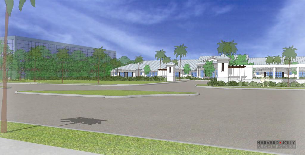
67
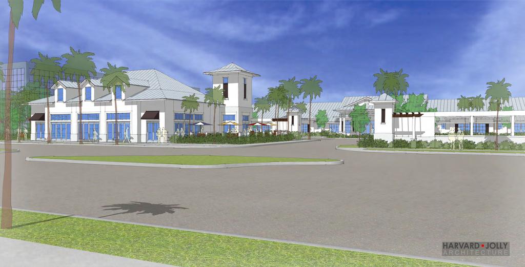
68
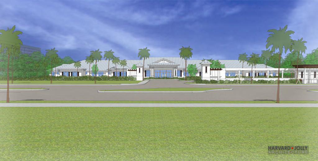
69
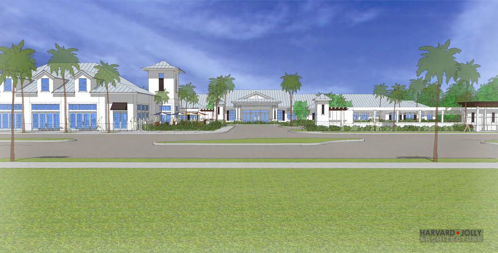
70

71
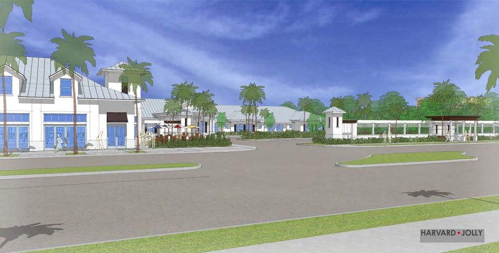
72
73
74
75
76
77
78
79

80 1 FieldColor: GreekVilaSW BaseColor: IvoryLaceSW Trim &AccentColor: BlackBeanSW 6006 R StandingSeam MetalRoof: GalvalumePlus NorthPalm Beach CommonsMemoryCare VilageofNorthPalm Beach Florida R CanvasAwning: Sunbrela-TrueBrown
 PROJECT NARRATIVE AVENIR PCD SITE PLAN #2 SITE PLAN REVIEW March 14, 2018 Request Avenir Holdings, LLC, the owner of the approved Avenir Planned Urban Planning and Design Landscape Architecture Communication
VILLAGE OF CLEMMONS PLANNING BOARD DRAFT STAFF REPORT
 VILLAGE OF CLEMMONS PLANNING BOARD DRAFT STAFF REPORT PETITION INFORMATION Docket # C-226 Staff Megan Ledbetter Petitioner(s) JBJH Properties, LLC Owner(s) JBJH Properties, LLC Subject Property 5892-49-1766
ORDINANCE WHEREAS, this Ordinance is consistent with the City of Winter Garden Comprehensive Plan; and
 ORDINANCE 17-06 AN ORDINANCE OF THE CITY COMMISSION OF THE CITY OF WINTER GARDEN, FLORIDA, CREATING ARTICLE XIV OF CHAPTER 118 OF THE CITY OF WINTER GARDEN CODE OF ORDINANCES PROVIDING FOR THE EAST PLANT
CHESAPEAKE LANDSCAPE ORDINANCE
 CHESAPEAKE LANDSCAPE ORDINANCE CONSERVATION PRESERVATION CZO 19-600 Effective October 16, 2008 BUFFER YARD C PARKING LOT REFORESTATION YEAR 1 REFORESTATION YEAR 4 BUFFER YARD F CBPA REFORESTATION Page
D1 September 11, 2013 Public Hearing APPLICANT:
 D1 September 11, 2013 Public Hearing APPLICANT: BEACH MUNICIPAL FEDERAL CREDIT UNION PROPERTY OWNER: SISTERS II, LLC STAFF PLANNER: Karen Prochilo REQUEST: Conditional Change of Zoning (AG-2 Agriculture
PRELIMINARY CONDITIONAL USE SUBMITTAL CHECKLIST REQUIREMENTS
 This checklist must accompany your submittal as the cover page. CONDITIONAL USE Application Submittal Checklist for PRELIMINARY AND FINAL APPROVAL Per Winter Park Land Development Code Sec. 58-90 PRELIMINARY
GENERAL INFORMATIONaaaaaaaaaaaaaaaaaaaaaaaaaaaaaaaa
 To: Planning and Zoning Commission From: City Staff Date: November 15, 2016 Re: Case #16026 Raymore Activity Center Site Plan GENERAL INFORMATIONaaaaaaaaaaaaaaaaaaaaaaaaaaaaaaaa Applicant/ Property Owner:
Staff Report to the North Ogden City Planning Commission
 Staff Report to the North Ogden City Planning Commission SYNOPSIS / APPLICATION INFORMATION Application Request: Concept review on a legislative application to rezone land located at approximately 1750
ARTICLE 17 SITE PLAN REVIEW
 ARTICLE 17 SITE PLAN REVIEW 17.01 INTENT AND PURPOSE The intent of this section is to provide for consultation and cooperation between the applicant and the township planning commission so that the applicant
AWH REPORT OF THE PLANNING AND DEVELOPMENT DEPARTMENT FOR APPLICATION FOR REZONING ORDINANCE TO PLANNED UNIT DEVELOPMENT
 AWH REPORT OF THE PLANNING AND DEVELOPMENT DEPARTMENT FOR APPLICATION FOR REZONING ORDINANCE TO PLANNED UNIT DEVELOPMENT MAY 8, 2014 The Planning and Development Department hereby forwards to the Planning
VILLAGE OF CLEMMONS PLANNING BOARD DRAFT STAFF REPORT. Single Family Residential, Townhomes
 VILLAGE OF CLEMMONS PLANNING BOARD DRAFT STAFF REPORT PETITION INFORMATION Docket # C-212 Staff Megan Ledbetter Petitioner(s) Peacehaven Development LLC Owner(s) Larry Jarvis, William Alexander and Peacehaven
REQUEST Current Zoning: O-15(CD) (office) Proposed Zoning: TOD-M(CD) (transit oriented development mixed-use, conditional)
 (office) Proposed Zoning: TOD-M(CD) (transit oriented development mixed-use, conditional)") Rezoning Petition 2016-117 Zoning Committee Recommendation January 4, 2017 REQUEST Current Zoning: O-15(CD) (office) Proposed Zoning: TOD-M(CD) (transit oriented development mixed-use, conditional) LOCATION
Rezoning Petition 2016-117 Zoning Committee Recommendation January 4, 2017 REQUEST Current Zoning: O-15(CD) (office) Proposed Zoning: TOD-M(CD) (transit oriented development mixed-use, conditional) LOCATION
TREASURE COAST REGIONAL PLANNING COUNCIL M E M O R A N D U M. To: Council Members AGENDA ITEM 5H
 TREASURE COAST REGIONAL PLANNING COUNCIL M E M O R A N D U M To: Council Members AGENDA ITEM 5H From: Date: Subject: Staff October 17, 2008 Council Meeting Local Government Comprehensive Plan Review Draft
MIDTOWN MIXED-USE VILLAGE. TECHNICAL DATA SHEET COMPONENT C-1 FOR PUBLIC HEARING - PETITION NUMBER Project No RZ1.1. Issued.
 N MIDTOWN MIXED-USE VILLAGE TECHNICAL DATA SHEET COMPONENT C- FOR PUBLIC HEARING - PETITION NUMBER 04-00 Project No. 496 Issued Revised SCALE: " = 0' N 0 0 0 40 RZ. c GENERAL PROVISIONS: a. SITE LOCATION.
D3 January 14, 2015 Public Hearing
 D3 January 14, 2015 Public Hearing APPLICANT: DONALD J. BOUCHER, JR. PROPERTY OWNER: D.J.B. SERVICE CENTER, LLC STAFF PLANNER: Kristine Gay REQUEST: A. Conditional Change of Zoning (I-1 to B-2) B. Conditional
CHAPTER 4 - LAND USE CLASSIFICATIONS
 CHAPTER 4 - LAND USE CLASSIFICATIONS Four new land use classification categories are established in the Gualala Town Plan: Gualala Village Mixed Use; Gualala Highway Mixed Use; Gualala Planned Development
MEMORANDUM AGENDA ITEM #6c
 South Florida Regional Planning Council MEMORANDUM AGENDA ITEM #6c DATE: FEBRUARY 1, 2010 TO: FROM: SUBJECT: COUNCIL MEMBERS STAFF CITY OF PARKLAND PROPOSED COMPREHENSIVE PLAN AMENDMENT (ALTERNATIVE REVIEW)
Request Modification of Proffers Approved by City Council on May 8, 2012 Modification of Conditions (Mini- Warehouse) Staff Recommendation Approval
 Staff Recommendation Approval") Applicant & Property Owner Salem Lakes Storage, LLC, a VA Limited Liability Company Public Hearing February 8, 2017 City Council Election District Centerville Agenda Item 4 Request Modification of Proffers
Applicant & Property Owner Salem Lakes Storage, LLC, a VA Limited Liability Company Public Hearing February 8, 2017 City Council Election District Centerville Agenda Item 4 Request Modification of Proffers
ARTICLE IX SPECIAL PERMIT USES
 ARTICLE IX SPECIAL PERMIT USES All special permit uses cited in Article IX and Attachment A of this Ordinance or any other Section of this Ordinance shall be subject to Site Plan Review. The procedures
Chapter Master Planned Communities (MPC) District
 District") Sections 14.53.010 Purpose and Intent 14.53.020 Applicability 14.53.030 Procedure 14.53.040 MPC Standards 14.53.050 Required Findings 14.53.010 Purpose and Intent Chapter 14.53 Master Planned Communities
Sections 14.53.010 Purpose and Intent 14.53.020 Applicability 14.53.030 Procedure 14.53.040 MPC Standards 14.53.050 Required Findings 14.53.010 Purpose and Intent Chapter 14.53 Master Planned Communities
Asbury Chapel Subdivision Sketch Plan
 Asbury Chapel Subdivision Sketch Plan PART 1: PROJECT SUMMARY Applicant: NVR Inc. Project Size: +/- 76.13 acres Parcel Numbers: 02101112,02116101,02116112, 02116113 Current Zoning: Transitional Residential
STAFF REPORT NATIONAL MEDAL OF HONOR MUSEUM
 STAFF REPORT NATIONAL MEDAL OF HONOR MUSEUM For reference, the Zoning Code and Land Development Regulations are available online. AGENDA ITEM: 5.b. Case #: Request: Location: Type of Request: Public Hearing:
Citizen Comment Staff Response Staff Recommended Revision Planning Committee
 Citizen Comment Staff Response Staff Recommended Revision Planning Committee Area No. 1: Owner desires retail land uses. Area No. 1a: Owner of two small parcels adjacent to Area No. 1 desires retail land
R E S O L U T I O N. Single-Family Residence/ Church. 2,488 sq. ft. 2,488 sq. ft. Area Parking Required: Church
 R E S O L U T I O N WHEREAS, the Prince George s County Planning Board is charged with the approval of Detailed Site Plans pursuant to Part 3, Division 9 of the Zoning Ordinance of the Prince George s
ARTICLE 6: Special and Planned Development Districts
 ARTICLE 6: Special and Planned Development Districts 6-10 Traditional Neighborhood Development (TND) District 6-10.10 Purpose and Intent The Traditional Neighborhood Development (TND) District provides
ARLINGTON COUNTY, VIRGINIA
 ARLINGTON COUNTY, VIRGINIA County Board Agenda Item Meeting of April 23, 2019 DATE: April 12, 2019 SUBJECT: SP #413 SITE PLAN AMENDMENT to permit a fixed bar in a private outdoor café space with associated
open public hearing and allow public comment request to continue LPA public hearing to January 16, 2014 at 10:30 am
 TODAY S AGENDA Work Session LPA Transmittal Public Hearing open public hearing and allow public comment request to continue LPA public hearing to January 16, 2014 at 10:30 am staff will issue a recommendation
MONTGOMERY COUNTY PLANNING DEPARTMENT THE MARYLAND-NATIONAL CAPITAL PARK AND PLANNING COMMISSION
 MONTGOMERY COUNTY PLANNING DEPARTMENT THE MARYLAND-NATIONAL CAPITAL PARK AND PLANNING COMMISSION MCPB Item No. Date: 3.10.2016 Site Plan 820160040 Nora School Parker Smith, Planning Technician, Area 1,
SUBMITTAL REQUIREMENTS
 WHEN PROCESS TYPE III IS USED References to Process Type III applications are found in several places in the Milton Municipal Code (MMC), indicating that the development, activity, or use, is permitted
DESIGN REVIEW COMMITTEE AGENDA ITEM
 DESIGN REVIEW COMMITTEE AGENDA ITEM AGENDA DATE: DECEMBER 16, 2015 TO: THRU: FROM: SUBJECT: Chair McCormick and Members of the Design Review Committee Leslie Aranda Roseberry, Planning Manager Kelly Christensen
that the Town Board of the Town of East Greenbush will hold a public hearing on April 11,
 TOWN OF EAST GREENBUSH NOTICE OF PUBLIC HEARING PLEASE TAKE NOTICE that the Town Board of the Town of East Greenbush will hold a public hearing on April 11, 2018, at 5:45 p.m. at the East Greenbush Town
TRANSPORTATION ELEMENT GOALS, OBJECTIVES, AND POLICIES
 TRANSPORTATION ELEMENT GOALS, OBJECTIVES, AND POLICIES GOAL 2 The City shall provide a safe, convenient, effective, and energy efficient multimodal transportation system which is coordinated with the Future
ORDINANCE NO. City of Bellingham City Attorney 210 Lottie Street Bellingham, Washington INFILL HOUSING ORDINANCE Page 1
 ORDINANCE NO. AN ORDINANCE RELATING TO LAND USE PLANNING AND ZONING, CREATING A NEW BMC CHAPTER 20.28 INFILL HOUSING, AND NEW SUBSECTION BMC 20.12.030.E, GREEN FACTOR LANDSCAPING STANDARDS, AND AMENDING
Beachside Redevelopment Committee
 Beachside Redevelopment Committee DRAFT FINAL RECOMMENDATIONS MARCH 22, 2018 This is a new slide 2 This is a new slide Table of Contents I. Introduction and Overview II. III. Community Improvements and
ARLINGTON COUNTY, VIRGINIA
 ARLINGTON COUNTY, VIRGINIA County Board Agenda Item Meeting of July 21, 2012 DATE: July 12, 2012 SUBJECT: SP #416 SITE PLAN AMENDMENT to modify condition #6 to eliminate requirement to provide a pedestrian
ORDINANCE NO WHEREAS, the City of Kalama has many areas of timberland and open areas inside its City limits adjacent to residential areas;
 ORDINANCE NO. 1342 AN ORDINANCE OF THE CITY OF KALAMA, WASHINGTON ADOPTING A NEW KALAMA MUNICIPAL CODE CHAPTER 17.20 ESTATE LOT FLOATING ZONE TO PROVIDE TRANSITIONAL ZONING OPTIONS FOR RESIDENTIAL DEVELOPMENT
Project phasing plan (if applicable) 12 copies of site plan
 12 copies of site plan") SITE PLAN REVIEW PERMIT APPLICATION City of Grand Haven, 11 N. Sixth Street, Grand Haven, MI 49417 Phone: (616) 847-3490 Fax: (616) 844-2051 Website: www.grandhaven.org 1. Project Information Address/location
SITE PLAN REVIEW PERMIT APPLICATION City of Grand Haven, 11 N. Sixth Street, Grand Haven, MI 49417 Phone: (616) 847-3490 Fax: (616) 844-2051 Website: www.grandhaven.org 1. Project Information Address/location
12 January 12, 2011 Public Hearing APPLICANT: TAILWIND DEVELOPMENT GROUP,LLC PROPERTY OWNER: CITY OF VIRGINIA BEACH
 12 January 12, 2011 Public Hearing APPLICANT: TAILWIND DEVELOPMENT GROUP,LLC PROPERTY OWNER: CITY OF VIRGINIA BEACH STAFF PLANNER: Faith Christie REQUEST: Conditional Change of Zoning (from PD-H1 Planned
Drexel, Barrell & Co.
 Drexel, Barrell & Co. June 18, 2018 Engineers/Surveyors Boulder Colorado Springs Greeley 3 South 7 th Street Colorado Springs, Colorado 80905-1501 719 260-0887 719 260-8352 Fax El Paso County Planning
CITY OF KEIZER MASTER PLAN APPLICATION & INFORMATION SHEET
 CITY OF KEIZER MASTER PLAN APPLICATION & INFORMATION SHEET PRE-APPLICATION CONFERENCE Prior to the actual filing of a Master Plan application, it is strongly recommended that the applicant contact Planning
2 January 14, 2015 Public Hearing
 2 January 14, 2015 Public Hearing APPLICANT & PROPERTY OWNER: PEMBROKE SQUARE ASSOCIATES, LLC STAFF PLANNER: Kevin Kemp REQUEST: Conditional Use Permit (Indoor Commercial Recreation Facility) ADDRESS /
PLANNED UNIT DEVELOPMENT Date: April 5, 2018
 PLANNED UNIT DEVELOPMENT Date: April 5, 2018 DEVELOPMENT NAME SUBDIVISION NAME LOCATION Robert Myers Robert Myers 2955 and 2989 Dauphin Street (Southeast corner of Dauphin Street and Sage Avenue) CITY
Project Name: MELWOOD HOTEL. Date Accepted: 1/12/04. Waived. Planning Board Action Limit: Plan Acreage: 1.7 Zone: Dwelling Units:
 The Maryland-National Capital Park and Planning Commission Prince George's County Planning Department Development Review Division 301-952-3530 Note: Staff reports can be accessed at www.mncppc.org/pgco/planning/plan.htm.
PLANNED UNIT DEVELOPMENT & SUBDIVISION STAFF REPORT Date: March 15, 2012
 PLANNED UNIT DEVELOPMENT & SUBDIVISION STAFF REPORT Date: March 15, 2012 DEVELOPMENT NAME SUBDIVISION NAME LOCATION OSR Subdivision OSR Subdivision 5559 Old Shell Road (South side of Old Shell Road, 570
PINE CURVE REZONING. BACKGROUND Purchased as two parcels in 2001 and 2002
 BACKGROUND Purchased as two parcels in 2001 and 2002 WHAT THE PROJECT IS AND IS NOT A Rezoning establishes the land use standards for Annexed and Zoned Greater Downtown District Historic Center September
PART 1: PROJECT SUMMARY. Proposed Land Use: 120 single-family lots. The application is Attachment A. The site plan is Attachment B.
 PART 1: PROJECT SUMMARY Applicant: JBH Development, LLC and Hopper Communities, INC Project Size: +/- 80.48 acres Parcel Number: 01513107, 01513108, 01513109, 01513113, 01513120, 01513121, 01513122, 01513124,
Baumgarten MPUD. Exhibit 3 Evaluation Criteria
 Pursuant to LDC subsections 10.02.13 B, 10.02.08 F and Chapter 3 G. of the Administrative Code, staff s analysis and recommendation to the Planning Commission, and the Planning Commission s recommendation
EAST LAKE TARPON COMMUNITY OVERLAY
 EAST LAKE TARPON COMMUNITY OVERLAY East Lake Tarpon in Pinellas County Florida physical area is defined by the boundaries of the as shown in the map below and legal description in Appendix A. VISION: East
Approved: CITY OF ARDEN HILLS, MINNESOTA PLANNING COMMISSION WEDNESDAY, AUGUST 5, :30 P.M. - ARDEN HILLS CITY HALL
 Approved: CITY OF ARDEN HILLS, MINNESOTA PLANNING COMMISSION WEDNESDAY, AUGUST 5, 2015 6:30 P.M. - ARDEN HILLS CITY HALL PLANNING CASES A. Planning Case 15-016; Final Planned Unit Development Arden Plaza;
Prepared by: Casey Kempenaar, Senior Planner
 CITY OF CITRUS HEIGHTS PLANNING DIVISION STAFF REPORT PLANNING COMMISSION MEETING September 13, 2017 Prepared by: Casey Kempenaar, Senior Planner REQUEST The applicant requests a Design Review Permit Modification
PINE CURVE REZONING. Property does not meet criteria for open space preservation and is not a candidate for a park
 PINE CURVE REZONING BACKGROUND Purchased as two parcels in 2001 and 2002 Annexed and Zoned Greater Downtown District Historic Center September 25, 2002 and October 7, 2002 WHAT THE PROJECT IS AND IS NOT
Application Number: SD Project Name: Walton Farms Preliminary Subdivision (acting as Master Plan)
") STAFF REPORT Town of Clayton Planning Department 111 E. Second Street, Clayton, NC 27520 P.O. Box 879, Clayton, NC 27528 Phone: 919-553-5002 Fax: 919-553-1720 Planning Board May 22, 2017 Application Number:
STAFF REPORT Town of Clayton Planning Department 111 E. Second Street, Clayton, NC 27520 P.O. Box 879, Clayton, NC 27528 Phone: 919-553-5002 Fax: 919-553-1720 Planning Board May 22, 2017 Application Number:
ARLINGTON COUNTY, VIRGINIA
 ARLINGTON COUNTY, VIRGINIA County Board Agenda Item Meeting of September 19, 2015 DATE: September 11, 2015 SUBJECTS: Outdoor Café at Citizen Burger Bar A. SP# 418 Site Plan Amendment to modify an approved
Gold Line Bus Rapid Transit Transit Oriented Development (BRTOD) Helmo Station Area Plan
 Helmo Station Area Plan") Appendix F Gold Line Bus Rapid Transit Transit Oriented Development (BRTOD) Helmo Station Area Plan Introduction and Purpose of the Plan The Gold Line Bus Rapid Transit facility is an eleven-mile dedicated
Appendix F Gold Line Bus Rapid Transit Transit Oriented Development (BRTOD) Helmo Station Area Plan Introduction and Purpose of the Plan The Gold Line Bus Rapid Transit facility is an eleven-mile dedicated
Planning Commission Staff Report June 5, 2008
 Owner/Applicant Taylor Village Sacramento Investments Partners, LP c/o Kim Whitney 1792 Tribute Road #270 Sacramento, CA 95815 Staff Recommendation Planning Commission Staff Report Project: File: Request:
Request Conditional Rezoning (R-15 Residential to Conditional A-24 Apartment) Staff Recommendation Approval. Staff Planner Jimmy McNamara
 Staff Recommendation Approval. Staff Planner Jimmy McNamara") Applicant Franklin Johnston Group Management & Development, LLC Property Owner Virginia Wesleyan College Public Hearing July 12, 2017 City Council Election District Bayside Agenda Item 3 Request Conditional
Applicant Franklin Johnston Group Management & Development, LLC Property Owner Virginia Wesleyan College Public Hearing July 12, 2017 City Council Election District Bayside Agenda Item 3 Request Conditional
PASCO COUNTY, FLORIDA INTEROFFICE MEMORANDUM. REFERENCES: Land Development Code, Zoning/Code Compliance. Section 306, Development Administrator
 PASCO COUNTY, FLORIDA INTEROFFICE MEMORANDUM TO: Development Review Committee DATE: 3/25/10 FILE: ZN10-162 SUBJECT: Class II, Commercial Development Review - Village Market at Wesley Chapel Variance Requests
CITY PLANNING COMMISSION AGENDA ITEM: C STAFF: ROBERT TEGLER FILE NO: CPC PUD QUASI-JUDICIAL
 CPC AGENDA June 8, 2006 Page 37 CITY PLANNING COMMISSION AGENDA ITEM: C STAFF: ROBERT TEGLER FILE NO: CPC PUD 05-294 - QUASI-JUDICIAL PROJECT: APPLICANT: OWNER: PARKWOOD AT WOLF RANCH NASS DESIGN ASSOCIATES
MIXED-USE VILLAGE OVERLAY FLOATING DISTRICT
 MIXED-USE VILLAGE OVERLAY FLOATING DISTRICT Zoning regulations developed by committee to the Planning Board for the Town of DeWitt, NY Issue date: 13 July 2017 revised 3/12/2018, revised 4/26/2018, 5/9/2018
City of Yelm. Tahoma Terra Final Master Plan Development Guidelines. Table of Contents
 City of Yelm Tahoma Terra Final Master Plan Development Guidelines Table of Contents Table of Contents... 1 Purpose... 2 Low Density Residential (R4-6)... 3 Moderate Density Residential (R6-10)... 5 Neighborhood
Staff Report. Conditional Use PLANNING DIVISION COMMUNITY & ECONOMIC DEVELOPMENT. Salt Lake City Planning Commission
 Staff Report PLANNING DIVISION COMMUNITY & ECONOMIC DEVELOPMENT To: From: Salt Lake City Planning Commission Maryann Pickering, Principal Planner (801) 535-7660 Date: December 10, 2014 Re: Church of Scientology
PLANNED DEVELOPMENT (MASTER PLAN & UNIT PLAN)
") Central Permit Center 555 Santa Clara Street Vallejo CA 94590 Business License Building Fire Prevention Planning Public Works 707.648.4310 707.648.4374 707.648.4565 707.648.4326 707.651.7151 PLANNED DEVELOPMENT
Central Permit Center 555 Santa Clara Street Vallejo CA 94590 Business License Building Fire Prevention Planning Public Works 707.648.4310 707.648.4374 707.648.4565 707.648.4326 707.651.7151 PLANNED DEVELOPMENT
PLANNED UNIT DEVELOPMENT & SUBDIVISION STAFF REPORT Date: May 18, 2017
 & PUD-0000102-2017 PLANNED UNIT DEVELOPMENT & SUBDIVISION STAFF REPORT Date: May 18, 2017 NAME SUBDIVISION NAME Dauphin Creek Estates Subdivision Dauphin Creek Estates Subdivision LOCATION CITY COUNCIL
VILLAGE OF CLEMMONS PLANNING BOARD DRAFT STAFF REPORT
 VILLAGE OF CLEMMONS PLANNING BOARD DRAFT STAFF REPORT PETITION INFORMATION Docket # C-214 Staff Megan Ledbetter Petitioner(s) Summit Healthcare Group Owner(s) Wake Forest University Health Services Subject
At Your Disposal CUP Amendment, Lot 20, Village Service Commercial, at 128 Bastille Dr. (PLN17-208)
") MEMORANDUM Archuleta County Development Services Planning Department 1122 HWY 84 P. O. Box 1507 Pagosa Springs, Colorado 81147 970-264-1390 Fax 970-264-3338 TO: Archuleta County Planning Commission FROM:
MEMORANDUM Archuleta County Development Services Planning Department 1122 HWY 84 P. O. Box 1507 Pagosa Springs, Colorado 81147 970-264-1390 Fax 970-264-3338 TO: Archuleta County Planning Commission FROM:
ARTICLE V PLANNED UNIT DEVELOPMENT DISTRICT
 ARTICLE V PLANNED UNIT DEVELOPMENT DISTRICT A. Purpose and Objective The Planned Unit Development (PUD) procedure provides a flexible land use and design regulation through the use of performance criteria
REPORT TO: Council FOR: Regular Meeting. PRESENTED: April 1, 2008 FILE: , Byl 1932 & 1936
 DISTRICT OF SQUAMISH REPORT TO: Council FOR: Regular Meeting PRESENTED: April 1, 2008 FILE: 2006-08, Byl 1932 & 1936 DEPARTMENT: Planning Department SUBJECT: First and Second Readings for Bylaws 1932 (rezoning)
The broad range of permitted and special uses allowed in the district remain, but some descriptions have been clarified.
 Memorandum To: Emily Fultz, AICP City Planner, City of Edwardsville From: Michael Blue, FAICP Principal, Teska Associates Date: January 24, 2019 RE: B-1 Zoning District Update A draft, updated B-1 Central
11 March 9, 2011 Public Hearing APPLICANT: BUDDHIST EDUCATION CENTER OF AMERICA DONG HUNG TEMPLE, INC. PROPERTY OWNER: MOY FAMILY, LLC
 11 March 9, 2011 Public Hearing APPLICANT: BUDDHIST EDUCATION CENTER OF AMERICA DONG HUNG TEMPLE, INC. PROPERTY OWNER: MOY FAMILY, LLC REQUEST: Conditional Use Permit for Religious use STAFF PLANNER: Karen
PLANNING REPORT CITY OF EAGAN. APPLICANT: Cedar Grove Hospitality, LLC HEARING DATE: December 18, 2014
 PLANNING REPORT CITY OF EAGAN REPORT DATE: December 8, 2014 CASE: 19-PA-11-11-14 APPLICANT: Cedar Grove Hospitality, LLC HEARING DATE: PROPERTY OWNER: The Flats at Cedar APPLICATION DATE: Nov. 21, 2014
City of Farmington. Downtown Plan. Amendment to the 1998 Master Plan Adopted October 11, 2004
 City of Farmington Amendment to the 1998 Master Plan Adopted October 11, 2004 Introduction Planning Background 1 Scope and Components of the Plan Amendment 2 Concept Introduction 3 Plan Concepts 3 Conceptual
COLVER ROAD INDUSTRIAL CONCEPT PLAN
 COLVER ROAD INDUSTRIAL CONCEPT PLAN A CONCEPTUAL LAND USE AND TRANSPORTATION PLAN FOR TA-4 AN URBAN RESERVE AREA OF THE CITY TALENT City of Talent Adopted by City Council Resolution No., June, 2015 PART
CASE NUMBER: 16SN0701 APPLICANT: Hanky, LLC
 STAFF S ANALYSIS AND RECOMMENDATION Planning Commission (CPC) Public Hearing Date: MAY 17, 2016 CPC Time Remaining: 100 DAYS Applicant s Agent: DANIEL L. CASKIE (804-569-7060) Applicant s Contact: MICHAEL
DEPARTMENT OF PLANNING JEFFERSON PARISH, LOUISIANA
 DEPARTMENT OF PLANNING JEFFERSON PARISH, LOUISIANA DESIGN REVIEW REPORT : CPZ-3-1 : (S) Cynthia Lee-Sheng AT LARGE: A Chris Roberts B Elton M. Lagasse ADVERTISING DATES: 06/03/1 06/10/1 06/17/1 PAB PUBLIC
Request Alternative Compliance (Commercial Parking Lot in Restricted Area) Staff Recommendation Approval. Staff Planner Ashby Moss
 Staff Recommendation Approval. Staff Planner Ashby Moss") Applicant Property Owners Pacific Avenue West, LLC Public Hearing April 11, 2018 City Council Election District Beach Agenda Item 2 Request Alternative Compliance (Commercial Parking Lot in Restricted
Applicant Property Owners Pacific Avenue West, LLC Public Hearing April 11, 2018 City Council Election District Beach Agenda Item 2 Request Alternative Compliance (Commercial Parking Lot in Restricted
EXISTING COMPREHENSIVE PLAN
 EXISTING COMPREHENSIVE PLAN Town Center Land Use Element: V. LAND USE POLICIES Town Center Mercer Island's business district vision as described in "Your Mercer Island Citizen-Designed Downtown" was an
Land Use Amendment in Southwood (Ward 11) at and Elbow Drive SW, LOC
 at and Elbow Drive SW, LOC") 2018 November 15 Page 1 of 10 EXECUTIVE SUMMARY This land use amendment application was submitted by Rick Balbi Architect on 2017 August 31 on behalf of Sable Developments Ltd, and with authorization from
2018 November 15 Page 1 of 10 EXECUTIVE SUMMARY This land use amendment application was submitted by Rick Balbi Architect on 2017 August 31 on behalf of Sable Developments Ltd, and with authorization from
MEMORANDUM. DATE: March 15, Chairman and Members Community Redevelopment Agency. Leif J. Ahnell, C.P.A., C.G.F.O. Executive Director
 MEMORANDUM DATE: March 15, 2019 TO: FROM: Chairman and Members Community Redevelopment Agency Leif J. Ahnell, C.P.A., C.G.F.O. Executive Director SUBJECT: Camino Square, IDA No. CRP-16-02, located at 171
4 January 11, 2012 Public Hearing APPLICANT:
 . 4 January 11, 2012 Public Hearing APPLICANT: MID-ATLANTIC AUTO PROPERTY OWNER: DZR, LLC STAFF PLANNER: Leslie Bonilla REQUEST: Conditional Use Permit (truck rental, automobile service, and automotive/bulk
REPORT OF THE PLANNING AND DEVELOPMENT DEPARTMENT FOR APPLICATION FOR REZONING ORDINANCE TO PLANNED UNIT DEVELOPMENT AUGUST 18, 2016
 REPORT OF THE PLANNING AND DEVELOPMENT DEPARTMENT FOR APPLICATION FOR REZONING ORDINANCE TO PLANNED UNIT DEVELOPMENT AUGUST 18, 2016 AWH The Planning and Development Department hereby forwards to the Planning
SUBDIVISION, PLANNED UNIT DEVELOPMENT, PLANNING APPROVAL, REZONING & SIDEWALK WAIVER STAFF REPORT Date: February 7, 2013
 SUBDIVISION, PLANNED UNIT DEVELOPMENT, PLANNING APPROVAL, REZONING & SIDEWALK WAIVER STAFF REPORT Date: February 7, 2013 APPLICANT NAME SUBDIVISION NAME DEVELOPMENT NAME LOCATION S. E. Cemeteries of AL
Mill Conversion Overlay District Zoning Bylaw Amendment
 Mill Conversion Overlay District Zoning Bylaw Amendment To see if the Town will vote to amend the Zoning By-Law by adding a new Section 13, Mill Conversion Overlay District, and by amending Sections 2.1,
2 January 13, 2010 Public Hearing APPLICANT: AUTOBELL CAR WASH, INC
 REQUEST: Conditional Use Permit (car wash) 2 January 13, 2010 Public Hearing APPLICANT: AUTOBELL CAR WASH, INC PROPERTY OWNER: MESSER 1060 INDEPENDENCE BOULEVARD STAFF PLANNER: Carolyn A.K. Smith ADDRESS
CITY PLANNING COMMISSION AGENDA. ITEM NO(s): C.1 C.3 STAFF: STEVE TUCK
: C.1 C.3 STAFF: STEVE TUCK") Page 34 CITY PLANNING COMMISSION AGENDA ITEM NO(s): C.1 C.3 STAFF: STEVE TUCK FILE NOS: CPC ZC 12-00035 QUASI-JUDICIAL CPC NV 12-00036 QUASI-JUDICIAL AR DP 12-00039 QUASI-JUDICIAL PROJECT: APPLICANT: OWNER:
Page 34 CITY PLANNING COMMISSION AGENDA ITEM NO(s): C.1 C.3 STAFF: STEVE TUCK FILE NOS: CPC ZC 12-00035 QUASI-JUDICIAL CPC NV 12-00036 QUASI-JUDICIAL AR DP 12-00039 QUASI-JUDICIAL PROJECT: APPLICANT: OWNER:
5 May 9, 2012 Public Hearing APPLICANT: MICHAEL H. NORMENT
 5 May 9, 2012 Public Hearing APPLICANT: MICHAEL H. NORMENT PROPERTY OWNER: JOAN DALIS REQUEST: Conditional Use Permit (Commercial Parking Lot) STAFF PLANNER: Faith Christie ADDRESS / DESCRIPTION: 3233
Chapter RM MULTI FAMILY BUILDING ZONES
 Chapter 19.17 RM MULTI FAMILY BUILDING ZONES 19.17.010 Established 19.17.020 Primary Permitted Uses 19.17.030 Accessory Permitted Uses 19.17.040 Secondary Permitted Uses 19.17.050 Conditional Property
CHARLES PUTMAN CHARLES PUTMAN AND ASSOCIATES, INC
 MEMORANDUM CHARLES PUTMAN & ASSOCIATES, INC. LAND DEVELOPMENT CONSULTANTS PLANNING ZONING PERMITTING 4722 NW Boca Raton Boulevard, Suite C-106 Boca Raton, Florida 33431 Phone: 561/994-6411 FAX: 561/994-0447
Glenborough at Easton Land Use Master Plan
 Implementation 114 9.0 IMPLEMENTATION 9.1 OVERVIEW This chapter summarizes the administrative procedures necessary to implement the proposed land use plan, infrastructure improvements, development standards,
ROAD CLOSURE AND LAND USE AMENDMENT SILVER SPRINGS (WARD 1) NORTHEAST OF NOSEHILL DRIVE NW AND SILVER SPRINGS ROAD NW BYLAWS 2C2018 AND 29D2018
 NORTHEAST OF NOSEHILL DRIVE NW AND SILVER SPRINGS ROAD NW BYLAWS 2C2018 AND 29D2018") Page 1 of 19 EXECUTIVE SUMMARY This application proposes redesignating two parcels in the community of Silver Springs from Special Purpose Future Urban Development (S-FUD) District and undesignated road
Page 1 of 19 EXECUTIVE SUMMARY This application proposes redesignating two parcels in the community of Silver Springs from Special Purpose Future Urban Development (S-FUD) District and undesignated road
Rezoning Petition Pre-Hearing Staff Analysis October 15, 2018
 Rezoning Petition 2017-137 Pre-Hearing Staff Analysis October 15, 2018 REQUEST Current Zoning: R-3 (single family residential) Proposed Zoning: B-2(CD) (general business, conditional) LOCATION Approximately
CITY COUNCIL STAFF REPORT
 COUNCIL AGENDA: 04/11/17 ITEM: W\0^ CITY OF e: :SS SAN JOSE CAPITAL OF SILICON VALLEY CITY COUNCIL STAFF REPORT File No. C16-030 Applicant: Alex Rubashevsky Location Northwest corner of Oakland Road and
9 CITY OF VAUGHAN OFFICIAL PLAN AMENDMENT NO BOCA EAST INVESTMENTS LIMITED
 9 CITY OF VAUGHAN OFFICIAL PLAN AMENDMENT NO. 631 - BOCA EAST INVESTMENTS LIMITED The Planning and Economic Development Committee recommends the adoption of the recommendations contained in the following
BACKGROUND / DETAILS OF PROPOSAL
 8 APPLICANT AND OWNER: MISSION ENTERPRISES, L.L.C STAFF PLANNER: Kristine Gay REQUEST: Conditional Use Permit ( Eating and Drinking Establishment within 100 of Protected District ) ADDRESS / DESCRIPTION:
TO: FROM: SUBJECT: Background
 TO: FROM: SUBJECT: Long Range Planning Committee and Zoning Committee of the Planning Commission Kellie Brown and Margaret Rhodes, Planning Division, CPHD DATE: June 8, 2017 Courthouse Square Implementation
Planned Development Review Revisions (Project No. PLNPCM )
") Planned Development Review Revisions (Project No. PLNPCM2014-00139) Standard residential development Planned Development Example: Smaller lot sizes than what is allowed to create open space amenity. What
Planned Development Review Revisions (Project No. PLNPCM2014-00139) Standard residential development Planned Development Example: Smaller lot sizes than what is allowed to create open space amenity. What
CITY OF PUYALLUP. Background. Development Services
 CITY OF PUYALLUP Development Services 333 South Meridian Puyallup WA 98371 To: City Council From: Katie Baker, AICP, Planning Division Re: South Hill Neighborhood Plan Adoption Date: (Meeting date: February
Request Alternative Compliance to the prescribed criteria of the Oceanfront Resort District Form-Based Code. Staff Planner Kristine Gay
 Applicant/Owner Ocean Rental Properties, LLC Public Hearing April 13, 2016 City Council Election District Beach Agenda Item 1 Request Alternative Compliance to the prescribed criteria of the Oceanfront
Request Alternative Compliance to the prescribed criteria of the Oceanfront Resort District Form-Based Code. Staff Recommendation Approval
 Applicant & Property Owner Public Hearing February 8, 2017 City Council Election District Beach Agenda Item D1 Request Alternative Compliance to the prescribed criteria of the Oceanfront Resort District
18 May 9, 2012 Public Hearing APPLICANT: BOUNCE HOUSE, LLC
 18 May 9, 2012 Public Hearing APPLICANT: BOUNCE HOUSE, LLC PROPERTY OWNER: MIKE LAGILLIA REQUEST: Conditional Use Permit (outdoor recreation facility) STAFF PLANNER: Ray Odom The applicant is requesting
Mitchell Ranch South MPUD Application for Master Planned Unit Development Approval Project Narrative. Introduction
 Mitchell Ranch South MPUD Application for Master Planned Unit Development Approval Project Narrative Introduction Mitchell Ranch South is a proposed single family (detached) residential development on