THE BEDFORD WEST SECONDARY PLANNING STRATEGY. Background
|
|
|
- Dora Sparks
- 5 years ago
- Views:
Transcription
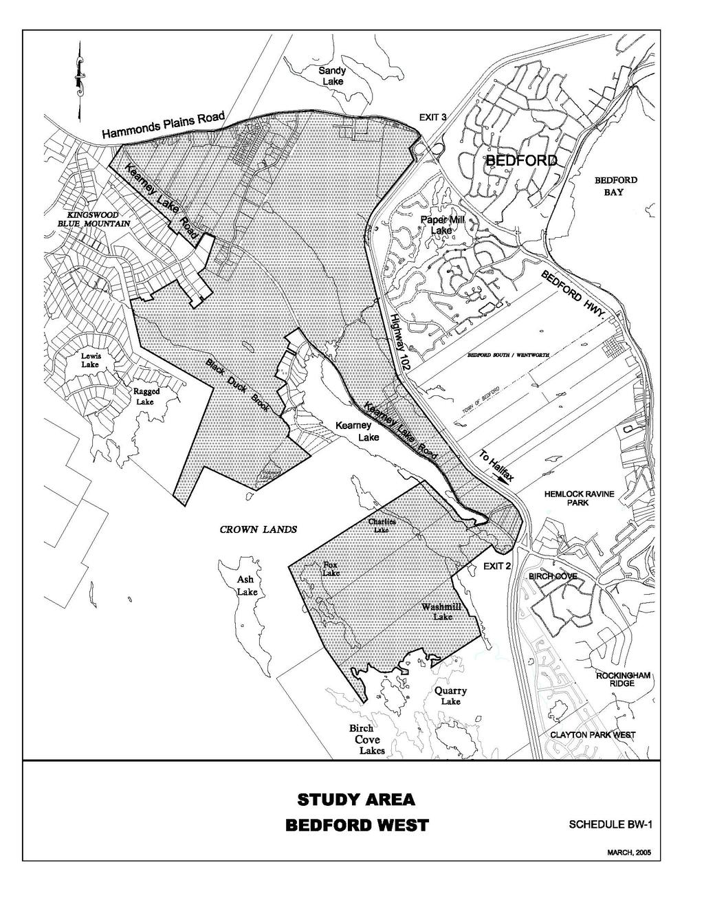
1 THE BEDFORD WEST SECONDARY PLANNING STRATEGY Background In 2002, Regional Council directed that a master planning study be undertaken on lands on the west side of the Bicentennial Highway, in the vicinity of Hammonds Plains Road and Kearney Lake Road. The study was initiated in response to requests from two property owners to allow for development on municipal sewer and water services. Annapolis Group Ltd. owned approximately 1,200 acres and proposed to develop a comprehensively planned community while several family members requested municipal approvals to allow for a further 40 acre expansion of Peerless Subdivision with single unit dwellings. In 2003, Council approved a study area boundary, study terms of reference and a public participation program 1. The study area boundaries, encompassing a total area of approximately 2,600 acres, are illustrated on Schedule BW-1. The terms of reference were to prepare conceptual community plans which: anticipate future community needs having regard for trends in demographics, housing affordability, building technologies, economics and social issues with specific consideration given to how the community proposed could fulfill a role in responding to needs within a regional context; integrate design with established neighbouring communities in terms of the natural and man made environment; reduce travel time and energy requirements, encourage the use of public transit, pedestrian and cycling facilities and enhance public safety through innovative integration of land use components with the transportation and open space systems; preserve sensitive environmental areas and unique cultural features and respond to the opportunities and constraints imposed by the environment; maintain adequate service levels for municipal infrastructure (sanitary sewer, storm drainage, potable water and road systems) both within the area of new development and off-site while minimizing costs to all parties; allow for design flexibility in recognition of future changes to external circumstances/market conditions; minimize future demands on the Municipality s fiscal resources (capital and operating budgets) and provide fair and predictable cost-sharing of community infrastructure costs between the Municipality and individual property owners in terms of division and timing in accordance with the Municipality=s Capital Cost Contribution Policy; provide policy guidance for more detailed negotiations with property owners/developers with specific consideration given to phasing of development with associated community infrastructure and the responsibilities of each party (property owners/developers and the Municipality. 1 Details can be found in a staff report re: Bedford West Master Plan (Project 00382), dated January 17, 2003 and presented at the February 25, 2003 session of Regional Council.
2
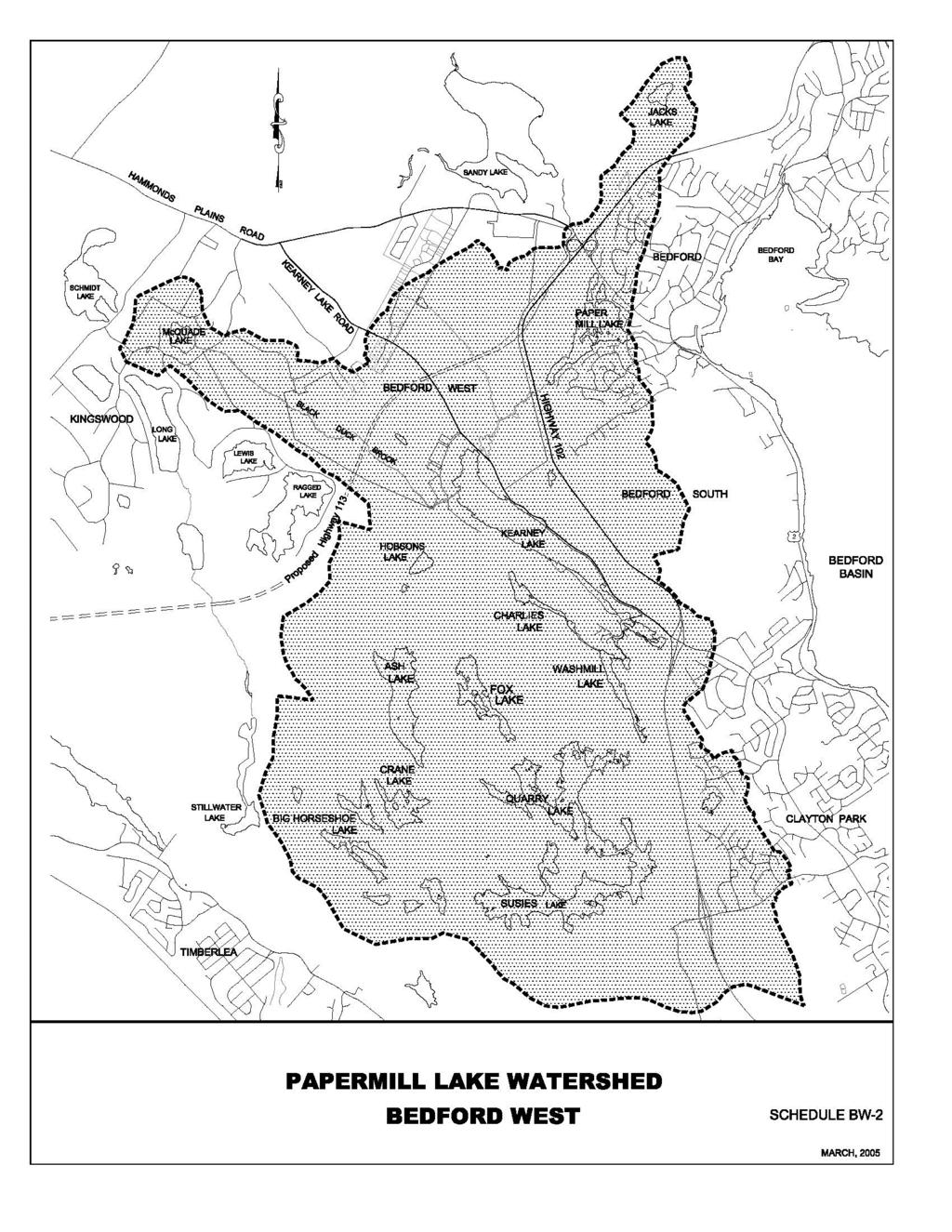
3 A public participation committee was appointed with citizen representatives from Bedford, Hammonds Plains, and Prince s Lodge/Clayton Park. The committee s mandate was to ensure the public had opportunities to express opinions; collaborate with staff and developers in preparation of a plan; provide advice on policy and regulatory documents proposed; and confer with the Regional Planning Advisory Committee (the RPC). The Bedford West master planning study was undertaken while a regional planning program that was being prepared under the supervision of the RPC. This secondary planning strategy has therefore been prepared in accordance with the master plan study terms of reference established by Council and in conformity with all relevant regional plan policies being proposed. Lakes and Watercourses Environmental Protection A vast majority of the study area is within Paper Mill Lake watershed which includes Washmill Lake, Quarry Lake and Suzie Lake. Dam structures control water elevations at the outlets of Paper Mill Lake, Kearney Lake and Quarry Lake. The dams which remain under the ownership of Annapolis Group have historically been used for power generation at a turbine on Moirs Mills. Today, the lakes are used for various recreational activities such as swimming, fishing and boating - activities which are highly valued by the surrounding communities and which are dependent upon maintenance of the dams. Annapolis Group has entered into negotiations with the Province pertaining to the upgrading of the dams and has proposed that control gates be introduced for flood control and storm water management purposes. Two studies: Bedford Dams Comprehensive Review (SGE Acres, October 2003) and Bedford West Stormwater Management Pre-Design Brief (SGE Acres, March 2004) were submitted by Annapolis to the Province in support of this proposal. The Municipality supports preservation of the dams and the introduction of flow control mechanisms which reduce flood risks and which further good stormwater management practices provided that lake levels are maintained within ranges needed to sustain recreation activities and maintain shoreline aesthetic. The Municipality also supports an ownership plan to ensure proper long term operation and maintenance of the dams. Annapolis Group also had two further studies prepared in support of it] s development proposal: Water Quality Assessment of Water Bodies Contained in the Bedford West Planning Area Using a Phosphorous Loading Model Approach (Dalhousie University Centre for Water Resource Studies, April 2004) and Bedford West Planning Area: Subwatershed Management Plan (Jacques Whitford, May 2004). The first study concluded that best management practices may be needed both during development and afterward to maintain a water quality in the lakes that is satisfactory for recreational activities. Leaching from septic fields from existing development in adjacent
4 areas may also contribute to phosphorous loading and mitigative measures may be needed over the long term. The study recommended that a monitoring program be established on lakes throughout the watershed. The Jacques Whitford study examined the characteristics of the watershed and the proposed development and prepared guidance for more detailed stormwater management plans. Objectives: to undertake storm water management planning on a watershed basis with community design based on natural drainage patterns; to prevent flooding of properties and safeguard flood plains; to preserve the water quality of lakes and rivers; to preserve groundwater flows; to support regional initiatives in solid waste recovery, Halifax Harbour remediation and watershed management. Policy BW-1: No development agreement shall be approved unless a master storm water management plan has been prepared, reviewed by the Bedford Waters Advisory Board and accepted by the Municipality. The management plan shall: a) identify significant constraints and sensitivities with regard to flood potential, and environmental features and provide appropriate protection measures; b) provide estimates of pre-development and post development flow rates (where post development flow rate means the expected flow rates upon full build out of an area as permitted by the development agreement) at critical locations within watercourses such as at culverts and other road crossings and at downstream developments; c) outline the type and location of storm water management facilities and the approach to protecting receiving waters from contamination, excessive flow rates and loss of aquatic habitat and to protect the quantity and quality of groundwater flows; and d) conform with the recommendations of the Bedford West Planning Area Subwatershed Management Plan (Jacques Whitford: May 2004) unless otherwise acceptable to the Municipality and the Province. Policy BW-2: No subdivision approvals shall be granted unless the detailed design specifications conform with the master stormwater management plan approved under policy BW-1. Policy BW-3: A water quality monitoring program shall be undertaken for the Paper Mill Lake watershed, illustrated on Schedule BW-2 to track the eutrophication process. The program is to be designed in accordance with national guidelines established by the Canadian Council for Ministers of the Environment (the CCME guidelines)and undertaken by a qualified persons retained by the Municipality and financed in whole or in part by developers within the watershed area. Specifics of the program are to be negotiated under
5
6 the terms of a development agreement in consultation with the Bedford Watershed Advisory Board. The monitoring program shall: a) specify the duration of monitoring for the pre-construction, construction and postconstruction phases of development. Pre-construction phase means a period of time before construction activity starts. Post-construction phase means a period of time that commences at full build out of the area permitted by a development agreement. Construction phase means the full time period between the pre-construction and post-construction phase); b) specify the physical and chemical water quality indicators to be measured, the location and frequency of testing and the format of submissions to the Municipality in each phase referenced under clause (a); c) establish physical and chemical water quality indicator threshold levels for the recreational uses of the lakes which would be used as a basis for reevaluating watershed management controls and future development potential within the area. The threshold indicators are to be established prior to any development approvals being granted; d) conform with all water quality policies, specifications, protocols and review and approval procedures approved by Regional Council. Policy BW-4: Where the Community Council is satisfied that a development agreement application has been made for a development proposal which could not be reasonably expected to impact the quality of water within the Paper Mill Lake watershed, the requirements of policy BW- 3 may be waived. The Community Council shall seek the advice of the Bedford Watershed Advisory Board before granting any waiver. Policy BW-5: In the event that water quality threshold levels, as specified under clause (c) of policy BW- 3, for Paper Mill Lake or Kearney Lake are reached, the Municipality shall undertake an assessment and determine an appropriate course of action respecting watershed management and future land use development in the area. An assessment shall consider the CCME guidelines. Water quality thresholds and any assessment reports shall be made available to the public. Policy BW-6: No stormwater shall be discharged directly into any natural watercourse without the use of mitigative measures as stipulated in under the stormwater management plan and in accordance with municipal and provincial guidelines. Policy BW-7: No development, grade alteration, excavation, fill, pavement or removal of natural vegetation shall be permitted within one hundred (100) feet of the high water mark, or within the limits of any 1 in 20 year flood plain of Kearney Lake, Kearney Lake Run or Black Duck Brook or within sixty-six (66) feet of the high water mark of any other
7 watercourse, or within the limits of any 1 in 20 year flood plain of any watercourse, except as provided for by development agreement in accordance with an approved water management plan approved pursuant to the provisions of policy BW-9 or as provided to allow for trail systems, transportation crossings or utilities. Preservation of Trees and Environmentally Significant Features: Objectives: to identify, preserve and maintain significant environmental features; to protect riparian buffer areas around lakes and watercourses; to minimize site disturbance, maximize tree retention and to restore trees over area which have been disturbed by development activities Policy BW-8: No development agreement shall be entered into over lands on which trees have been removed except: a) as may be required for a bonafide land survey; b) to satisfy any provincial or federal requirements; or c) where, in the opinion of Council, the extent of such cutting would not preclude achieving the three objectives stated above. Policy BW-9: Within any watercourse protection setback established under policy BW-7, no vegetation or soil shall be removed or altered unless a management plan has been approved to provide for restoration of vegetation, shoreline access paths, habitat management, safety and welfare or shoreline recreation where such provisions may be made without adversely affecting the primary purpose of preserving water quality in the lake. Any study or management plan submitted pursuant to this clause shall be prepared by a person qualified to make the required determinations and an approval procedure shall be established under the terms of a development agreement. Policy BW-10: Wetlands, lakes, watercourses, endangered species habitat and any other features of environmental significance shall be delineated as non-disturbance areas under development agreements. Non-disturbance areas shall be located to allow for continuity of non-disturbance areas on abutting lots, municipal parkland and open space dedications, and natural areas adjacent to watercourses. Policy BW-11: A tree replanting program shall be incorporated into development agreements. The program shall specify the locations, number, type and diameter of trees to be planted. The type of trees shall be indigenous to Nova Scotia. Policy BW-12: Development of major land areas on slopes in excess of twenty-five percent (25%) shall be prohibited under any development agreement except where it can be demonstrated that
8 such development would not create any hazard and could better preserve open spaces or areas of environmental value. Policy BW-13: The Municipality may allow for modifications to the service system specifications adopted under subdivision regulations where such modifications would enhance the ability to preserve the natural environment without compromising the intended objectives of the service systems. Municipal Services The feasibility of servicing the Bedford West area was examined and compared to ten other potential development areas around the metropolitan area under the regional planning program. A study concluded that Bedford West was one of two study areas with minimal constraints to development and had low servicing costs per acre 2. Servicing costs were deemed low because there was already considerable infrastructure in the area which could be utilized for new development. The transmission main from the Pockwock Lake water supply to Halifax extends along Kearney Lake Road making a potable water supply readily available. Halifax Regional Water Commission had previously commissioned a study to determine infrastructure needed to service this area 3. Traffic from Bedford West is easily accessible to the Bicentennial Highway - a principle arterial road for the region - via interchanges at the Hammonds Plains Road and Kearney Lake Road and from a future interchange proposed with Larry Uteck Boulevard. Annapolis Group Ltd., the major land owner within the Bedford West study area, prepared a transportation plan which concluded that minimal investment in transportation infrastructure would be required by the Municipality to facilitate development of this area 4. The study identified transportation upgrades needed and a phasing plan. Through the regional planning program, the Municipality has sought to encourage alternative transportation modes to the automobile. Bedford West is well situated to integrate with regional transit and trail systems and consideration was given to how the community could be designed to take advantage of these attributes. Bedford West could be connected to either the municipal sanitary collection sewer system which is discharged to Mill Cove treatment plant or to the system which will discharge to the new Halifax treatment plant. In both instances, sewage would have to be pumped to 2 CBCL Ltd. & Marshall Macklin Monaghan. Final Report: Greenfield Areas Servicing Analysis Report. Prepared for Halifax Regional Municipality. July CBCL Ltd. Birch Cove North/Bedford West Water Infrastructure Master Plan. Prepared for Halifax Regional Water Commission. February MRC Delphi. Bedford West Master Plan: Transportation Study. February 2004.
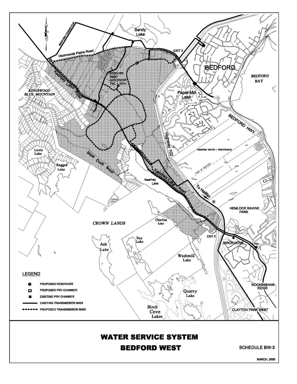
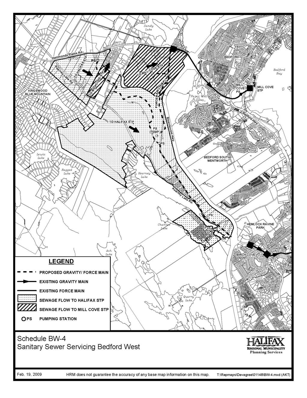
9 existing gravity mains in the Hammonds Plains Road (discharging to Mill Cove) or in Kearney Lake Road (Halifax system). Careful consideration was given to available capacities for new development when allocating sewage flow from Bedford West to each of these systems. A development phasing plan has been developed which integrates various servicing needs and, in accordance with the Municipality s capital cost contribution policy, an infrastructure charge area will be established under the subdivision by-law to recover the costs of infrastructure needed to accommodate new development. Objectives: to ensure that the municipal servicing systems are designed to satisfy the ultimate demands anticipated from this community and that services are phased with development to provide satisfactory service levels at all times; to employ service standards that are economical and innovative, and that achieve municipal objectives and policies, including public safety, healthy lifestyles and environmental protection; to safeguard the capacity of the Halifax and Mill Cove sewage treatment plants; to facilitate the safe and convenient movement of pedestrians and cyclists within the community and to surrounding neighbhourhoods; to allow for a convenient and cost efficient public transit system that can provide a high level of service to residents in the community and which can integrate with the regional public transit system; to encourage synergy between land uses, lifestyle needs and transportation modes; to minimize motor vehicle traffic impacts on the regional transportation system; to preclude excessive traffic levels in residential neighbourhoods; to allow for efficient access to places of commerce and employment in the community; to recover the cost of new infrastructure needed to service development within the secondary plan areas in accordance with the capital cost contribution policy adopted by the Municipality. Water and Sanitary Sewer Systems: Policy BW-14: The water distribution system shall conform with the recommendations of the Birch Cove North/Bedford West Water Master Infrastructure Plan (CBCL, 1999) and with the system schematics illustrated on Schedule BW-3 unless otherwise acceptable to the Halifax Regional Water Commission and no development shall be approved by the Municipality unless notified by the Commission that the proposed distribution system conforms with all design and operating specifications established. Policy BW-15: The sanitary sewer system shall be designed in conformity with the schematics illustrated on Schedule BW-4 and in accordance with the Municipality s Service Systems Specifications, as amended from time to time. Sewage flow calculations, shall be based on
10
11
12 an assumed occupancy of 3.35 persons per single unit, two-unit or townhouse dwelling and 2.25 persons per unit in each multiple unit dwelling; 50 persons per acre for general commercial uses within the Community Commercial Centre shown on Schedule BW-7 or proposed within Sub-Area 9; and 40 persons per acre for mixed use business campus uses; and 30 persons per acre for local commercial, community facility and institutional uses 5. Policy BW-16: Based on the assumed occupancies under policy BW-15 and the phasing plan illustrated on schedule BW-6, the sanitary sewer system shall be designed to satisfy the following conditions: a) a maximum density of 40 persons per acre shall be permitted for all lands to be developed as a mixed use business campus within Sub-Area 3; b) a maximum density of 50 persons per acre shall be permitted for all lands designated community commercial centre within Sub-Areas 2, 6, 7 and 8 as illustrated on schedule BW-7 or proposed for general commercial uses within Sub- Area 9 and 12; c) For all other Sub-Areas or part thereof, a maximum density of 20 person per acre shall be permitted; and d) the temporary pumping station and forcemain, illustrated as PS (TEMP) and FORCEMAIN (TEMP) on schedule BW-4, shall be permitted to service a maximum of 6,100 persons where upon the permanent pumping station and forcemain along the Kearney Lake Road must be designed and constructed to service all lands intended to flow to the Halifax Sewage Treatment Plant (as illustrated on schedule BW-4). This requirement may be waived if: i) the financing for the construction for the permanent pumping station and forcemain has been secured by the Municipality and a time frame for construction agreed upon; and ii) there is sufficient capacity remaining in the temporary pumping station and forcemain to allow for additional sewage discharge to the Mill Cove Sewage Treatment Plant. In the event that any Sub-Area is not developed to the maximum permitted density, the Municipality may consider allowing the difference to be allocated to another Sub-Area provided that the development proposal conforms will all other policies established under this secondary planning strategy. Policy BW-16A: The maximum permitted population for Sub-Area 9 (including portions within the Halifax Municipal Planning Strategy) shall not exceed 1476 persons. (RC-Mar 15/11;E-May 28/11) 5 For the purposes of this Secondary Planning Strategy, all density calculations are based on gross area.
13
14
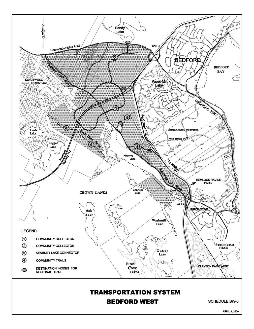
15 Transportation: Policy BW-17: A comunity street and trail system shall be developed in substantial conformity with the designations and alignments presented on Schedule BW-5 except that variations to the alignment may be considered to enhance safety, provide a better fit with the natural terrain, mitigate surface runoff or preserve significant environmental features. The following requirements shall be applied: a) the connector road from Kearney Lake Road to the Larry Uteck Drive interchange shall be designed with a right-of-way width sufficient to allow for two lanes of through traffic with turning lanes at intersections. Direct driveway access shall be restricted to commercial developments in the vicinity of the interchange and all other access shall be restricted to street intersections. The need for sidewalks will be determined at the time a street plan is submitted in association with a development agreement for Sub-Area 9 as illustrated on Schedule BW-6; b) the Community Collector Road shall be designed as an urban minor collector with sufficient right-of-way width for two lanes of traffic, turning lanes, where required, and sidewalks on both sides. Direct driveway access shall be restricted to commercial developments, apartment buildings, institutions and clustered housing developments comprised of at least eight housing units with one driveway access to the Community Collector Road. One or more rotaries may be permitted; c) a regional trail system shall be designed to connect with the destination nodes illustrated on BW-5. d) community trail systems shall be constructed by the developer of the lands on which it is located with the design specifications negotiated under a development agreement. Trails shall be designed and constructed in accordance with the Guidelines of the Nova Scotia Trails Federation unless otherwise acceptable to the Municipality. Variations to the Municipal Service Specifications for sidewalks may be considered where a trail is proposed which would provide improved accessibility for pedestrian travel in the community; and e) phasing of transportation system upgrades shall be undertaken in accordance with the recommendations of the Transportation Plan (MRC Delphi, February 2004) unless otherwise agreed to by the Municipality and the Province. Policy BW-18: The Municipality shall prohibit motorized conveyances on all trails, except maintenance, emergency or patrol vehicles, and except electric wheelchairs or similar devices required for mobility by persons with disabilities. Policy BW-19: Variations to municipal service system standards may be considered where such variations conform with the principles set forth in the Transportation Association of Canada=s AA New Vision for Urban Transportation@ or any other guidelines or policies acceptable to the Municipality. Consideration shall be given to the objectives and policies established under
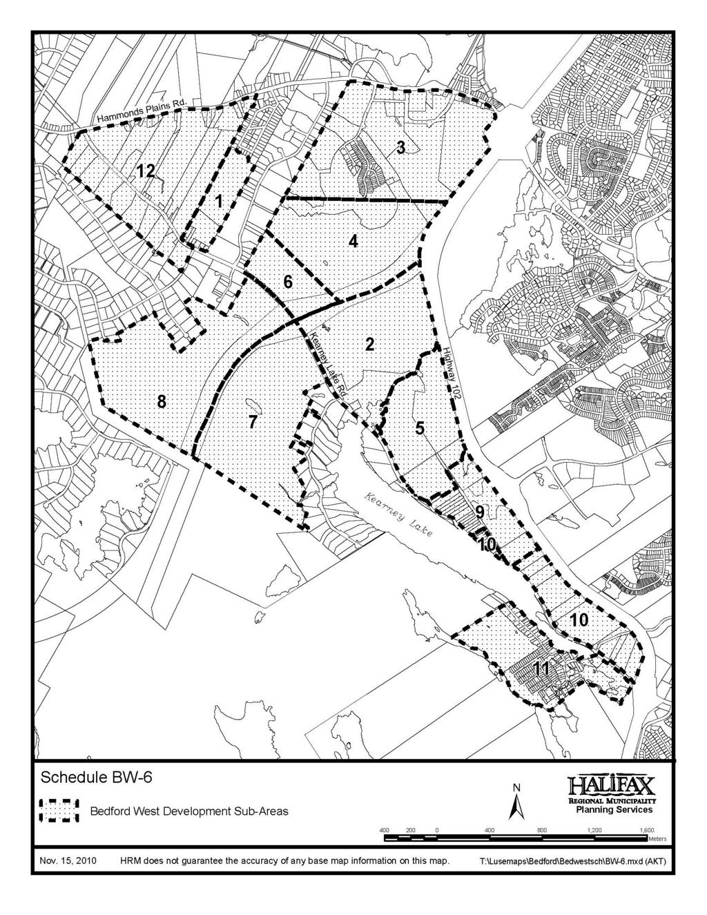
16 this Municipal Planning Strategy, public safety, environmental and lifestyle factors, and capital and operating costs as well as other benefits to the Municipality, such as construction of trail systems on public lands. Development Phasing and Cost Recovery Policy BW-20: A development Sub-Area plan is established for this secondary plan area as illustrated on Schedule BW-6 in which the following conditions shall apply: a) Any approvals within Sub-Areas 1 to 12 will also be contingent upon availability of capacity within municipal service systems; b) any development agreement entered into within Sub-Areas 2 to 8 and 12 shall include provisions for all new development intended within the Sub-Area; c) any development agreement for Sub-Area 4 will require that either (i) the community collector road be completed from the Kearney Lake Road to the Hammonds Plains Road through Sub-Areas 2 and 3 or (ii) the community collector road is constructed through Sub-Area 6 to the Kearney Lake Road; d) approval for Sub-Area 6 may not precede Sub-Area 4 but approvals for both Sub- Areas may be considered concurrently and approval for Sub-Areas 3 and 4 may be considered concurrently; e) no municipal approval for Sub-Area 5 will be given until development agreements have been entered into for Sub-Areas 2, 3 and 4 or Sub-Areas 2, 4 and 6 but nothing will preclude allowing development to commence before completion of Sub-Areas 2, 3, 4 or 6; f) no municipal approvals will be granted for Sub-Areas 7, 8 and 9 until the Highway 102/Larry Uteck Drive interchange and Kearney Lake Road connector are constructed or financing has been secured and a time frame for completion agreed upon; g) no development agreement shall be entered into for Sub-Areas 5 unless a servicing and phasing plan has been prepared and included in the agreement for the extension of municipal sewer and water services to both Sub-Areas 5 and 9. h) The requirement of clause (g) may be waived if a development agreement for Sub- Area 9 has been approved prior to an application for Sub-Area 5 and the agreement provides for the extension of municipal services to Sub-area 9 at no cost to the Municipality. Policy BW-21: In accordance with the provisions and requirements of the Municipality=s Infrastructure Charges Best Practice Guide and Part II of this Municipal Planning Strategy, an infrastructure charge area shall be established under the Subdivision By-law over the area governed by this Secondary Planning Strategy and no subdivision approvals shall be granted until infrastructure charges are in effect. Land Use The following development guidelines are based on Schedule BW-6: Development Phasing.
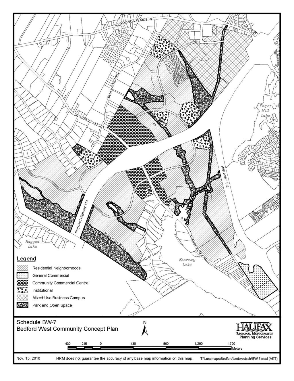
17 Sub-Area 1 This Sub-Area approximately 45 acres of undeveloped land on which an extension of the Peerless Subdivision is proposed. All lots are to be developed with single unit dwellings on central sewer and water services. The extension is to be serviced with an extension of the sanitary sewage collection system which discharges into the Mill Cove treatment plant. The local street system shall be designed so as to discourage traffic external to this Sub-Area and Peerless Subdivision traveling between Kearney Lake Road and Hammonds Plains Road. Policy BW-22: Sub-Area 1 shall be designated Residential on the Generalized Future Land Use Map of this Municipal Planning Strategy and zoned Residential Single Unit (RSU) under the Land Use By-law. The Community Concept Plan (Sub-Areas 2, 3, 4, 6, 7, and 8) A Community Concept Plan has been prepared over lands owned by Annapolis Group Inc. - the major land owner within the master plan study area, as well as a 50 acre parcel owned by the Municipality adjacent to the Hammonds Plains Road/Bicentennial Highway interchange. The Plan, presented as Schedule BW-7, illustrates the main land use and transportation elements proposed. The design principles incorporated into the plan are highlighted as follows: Lands needed for daily living activities - housing, shops, workplaces, schools, parks, and civic facilities - are integrated within the community; The community collector streets facilitate efficient public transit routes which can provide a high level of service to the residential neighbourhoods and activity centres within the community and which conveniently connect with the regional transit system; Lands bordering Kearney Lake and Kearney Lake Run which are valued by the community for their aesthetics and recreational potential have been reserved for public uses; A sidewalk and trail system extends throughout the community which connects residents to the park system, commercial and other activity centres, and a future regional trail system which would extend from Clayton Park to Jacks Lake; The street system has been designed to prevent external traffic from traveling on local streets while accommodating pedestrians and cyclists throughout the community; The residential neighbourhoods encompass lands of varying topography allowing for differing identities and a range of housing opportunities within each; Lands have been allocated for a mixed use business campus adjacent to the Hammonds Plains Road/Bicentennial Highway which can potentially provide employment opportunities for residents of Bedford West and the surrounding community without introducing additional traffic on local residential streets.
18 The Community Concept Plan provides guidance for the overall development of this community. More detailed objectives and policies for each element are presented in the following sections. Policy BW-23: The Community Concept Plan, presented as Schedule BW-7, shall form the framework for land use allocation within the master plan area and all policies and actions taken by the Municipality shall conform with the intent of this plan. A comprehensive development district zone shall be applied to all lands within the community concept plan area and any development of the land shall be subject to approval of a development agreement. In the event that the lands allocated for the proposed Highway 113 right-of-way are not required by the Province for a highway, then the lands may be used for development permitted within the abutting land use designation. Policy BW-24: To facilitate a variety of housing types and achieve both the overall density and open space allocations envisioned by the Regional Plan, consideration may be given to varying development standards established under the Bedford Municipal Planning Strategy and Land Use By-law. More specifically standards pertaining to lot area, lot frontage, lot coverage, setbacks and building height may be varied to reflect the uniqueness of each Sub- Area, the market being targeted and the theme of that Sub-Area. If required, terms may be incorporated in a development agreement to ensure functional and aesthetic objectives are achieved. (RC-July 8/08;E-Aug 9/08) Parks and Open Space The Open Space Designation encompasses lands around the major watercourses traversing the study area - Kearney Lake, Kearney Lake Run and Black Duck Brook - as well as smaller watercourses. These lands offer opportunities for recreational activities, environmental protection and preservation of areas which are highly valued for their aesthetics. Within these areas, paths for pedestrians and cyclists are proposed as well as facilities for passive recreational activities. Areas for active playgrounds are more centrally located. Four sites have been reserved for schools along the community collector road where sports fields and playgrounds would be suitably located. Neighbourhood parks are to be integrated within residential areas. Policy BW-25: The areas designated as Open Space on Schedule BW-7 shall be reserved for recreational uses, conservation uses including stormwater management and environmental protection. Provided that the area of the designation is not materially reduced, the boundaries of the Open Space Designation may be varied where such changes provide: a) enhanced protection of environmentally sensitive site features; b) more opportunity for preservation of significant aesthetic features; c) more suitable lands for recreational uses; or
19
20 d) a more functional trail system for pedestrians and cyclists. The intended purpose of all open spaces shall be identified and agreed to in a development agreement application. Lands within the Open Space Designation may be allocated to satisfy the Municipality s Subdivision By-law requirements for parkland dedication. Policy BW-26: Street crossings of the Open Space Designation shall be minimized and any trail development within a watercourse buffer zone established under policy BW-7 shall be subject to the requirements of policy BW-9. Policy BW-27: No stormwater management, sanitary sewer or water service system shall be located within the Open Space Designation which would adversely affect environmentally sensitive areas, detract from the aesthetics of the area or impair any recreational functions intended. Policy BW-28: In the event that the Municipality is unable to determine whether any undertaking will adversely affect environmentally sensitive areas, the Municipality shall require that an environmental impact analysis be undertaken at the cost of the developer by a person qualified to make such a determination and as selected or agreed upon by the Municipality. Policy BW-29: The development of all recreational facilities shall conform with the HRM Guidelines for Parkland Planning adopted by Council. Policy BW-30: Prior to any subdivision approval being granted, the developer shall prepare a recreation facilities plan for the development of recreational facilities for lands to be conveyed to the Municipality for parkland and open space dedication. The plan shall consider facility requirements in relation to present and future community needs, safety and convenience, environmental protection or enhancement, financial resources and phasing. Policy BW-31: Community parks are intended to be located on lands reserved for schools within the Institutional/Residential designation shown on Schedule BW-7. In the event that schools are not developed on these lands, the Municipality may require that these lands or portions thereof be reserved for community parks. Residential Neighbourhoods The following objectives have been identified for residential development within this community: to plan neighbourhood development on a comprehensive basis; to support and integrate housing opportunities for a variety of income levels, lifestyles and age groups;
21 to foster individual neighbourhood identities with attractive streetscapes and distinctive architectural and landscaping themes; to preserve natural drainage systems and areas of unique or sensitive terrain and vegetation and to encourage development designed to suit the natural terrain and reduce negative impacts on the natural environment; to provide attractive, comfortable and convenient routes for pedestrians and cyclists that connect with the community trail system, local commercial and community facilities and public transit stops; to provide neighbourhood parks at convenient locations that are comfortable, visible and conform with the principles of crime prevention through environmental design (CPTED); to encourage innovative design within clearly defined performance criterion; to provide an effective integration with established neighbourhoods and to provide for adequate buffers from abutting commercial and industrial developments. Policy BW-32: The following matters shall be considered for all development agreement applications within a Residential Neighbourhood Designation shown on Schedule BW-7: a) the density of housing units shall not exceed six units per acre per Sub-Area except that if the maximum density permitted in one development Sub-Area is not achieved, the Municipality may consider transferring the difference between the maximum permitted and actual number of housing units to another development Sub-Area provided all policy criterion can be satisfied and the housing density does not exceed seven units per acre in any development Sub-Area; b) community facilities such as schools, churches and day care centres and businesses that provide goods and services at a neighbourhood level, such as convenience stores, may be permitted within a residential neighbourhood. Convenience stores shall be encouraged to locate at intersections with a Community Collector Street and at transit stops; c) sidewalks and pathways facilitate comfortable and convenient pedestrian travel to transit stops on the Community Collector Street System, the Community Trail System and to community services; d) the design of neighbourhood streets facilitate shared use by cyclists and encourage safe vehicular speeds and discourage short-cutting and excessive speeds by automobiles while enabling direct routes for pedestrians and cyclists; e) a variety of housing types is provided within each Sub-Area and distributed so as to avoid a congested appearance of streetscapes. Consideration shall be given, but not limited, to the design guidelines of policies R-12A, R-12B and R-12C of the Municipal Planning Strategy, although the limitations placed on building height and units per building under policy R-12A shall not be applied; f) the allocation of housing and the massing and placement of buildings contributes to a sense of community vitality, energy conservation, surveillance of public spaces and provides an effective integration with established neighbourhoods; g) building locations, height, scale, site and architectural design, landscaping, and streetscape elements reinforce the themes of neighbourhood identity, pedestrian safety and compatibility with the natural environment;
22 h) single unit dwelling lots have a minimum street frontage of 40 feet, a minimum area of 4,000 square feet, a minimum side yard of 4 feet, and a minimum separation of 12 feet between buildings; i) natural vegetation, landscaping or screening is employed around parking areas for institutional and multiple unit buildings to provide screening from streets and, for buildings containing forty-eight or more housing units, provision of underground parking or a structure allowing for stacked parking shall be a mandatory component of the on-site parking supply; j) Vegetation is maintained or landscaping measures, a fence or other physical barrier provided so as to provide a buffer between new developments and commercial or industrial developments which is effective in ensuring public safety and mitigating visual or noise impacts; k) all open space dedications proposed conform with the objectives and polices adopted for open space under this secondary planning strategy and any administrative guidelines adopted by the Municipality; and l) the proposal conforms with all applicable provisions and requirements adopted under this Secondary Planning Strategy regarding environmental protection, the community transportation system and municipal services. Policy BW-32A: Notwithstanding clause (h) of policy BW-32, within Sub-areas 2, 3, and 4 (RC-May 20/14;E-Jun 14/14) of Schedule BW-6, single unit dwelling lots may be permitted on lots with a minimum street frontage of 34 feet, a minimum area of 3,400 square feet, a minimum side yard of 4 feet, and a minimum separation of 12 feet between buildings provided that each dwelling contains on-site parking for two vehicles with one being an enclosed parking space within the dwelling and consideration is given to policy BW-24. (RC-Jul 8/08;E-Aug 9/08) The Community Commercial Centre The Community Centre Designation envisions a built form with a diverse range of commercial, civic and residential activities. The following objectives are intended: to provide a focus for pedestrian oriented community and commercial activities with the community; to create a built form reminiscent of a town square or main street; to foster activities for all ages and a wide range of lifestyles in a safe and secure environment; to encourage innovative design and comprehensive planning; to support public transit. Policy BW-33: A range of community commercial, higher density residential, institutional, and recreational uses may be permitted within the Community Commercial Centre Designation shown on Schedule BW-7 subject to consideration of the following matters: a) preference is given to limiting parking or loading areas between a building and the Kearney Lake Road or the Community Collector Road and any buildings with
23 commercial occupancies should be located in close proximity to the street line; b) natural vegetation, landscaping or screening is employed around parking areas and measures are employed to provide safe and convenient pedestrian access to the buildings they are intended to serve; c) sidewalks and plazas are provided so as to encourage a secure and inviting walking environment throughout the commercial centre and to neighbouring residential neighbourhoods; d) provisions are made for the storage of bicycles; e) exterior materials, street furniture; trees, lighting and landscaping measures are incorporated in buildings to foster an interesting and secure environment; f) the windows, exterior features and materials and signs employed in any building create a sense of interest from public streets; g) the massing and height of buildings are consistent with and contribute to an pedestrian oriented environment; h) the proposal conforms with all applicable provisions and requirements adopted under this Secondary Planning Strategy regarding environmental protection, the community transportation system and municipal services. The Community Commercial Centre Designation might also be ideally located for public transit and park and ride facilities which could be utilized by residents of neighbouring subdivisions, such as Kingswood and Blue Mountain, where direct transit provision is not feasible. Policy BW-34: The Municipality may enter into an agreement to lease or purchase lands within the Community Commercial Centre Designation for public transit and park-and-ride facilities on either a temporary or permanent basis. Site preference will be given to lands directly abutting a Community Collector Road and from which access from Kearney Lake Road or the Community Collector Road could be conveniently and safely secured. Such facilities may include parking structures. The need to provide for the needs of residents of Bedford West is key to the Commercial Designation, further to this, the need to provide for the sale of gasoline to residents of Bedford West has been identified. Policy BW-34A: Within the Community Commercial area it shall be the intention to enable the sale of gasoline at gas bars located proximate to the commercial and transportation core of Bedford West. Further, the establishment of other Highway Commercial uses such as automotive service uses shall not be considered as they are more appropriate in the General Commercial area. Council may consider the establishment of design, architectural and aesthetic guidelines for gas bars within the Community Commercial area to ensure that gas bars are designed appropriately. Regulations shall be established through the Bedford Land Use By-law to limit the permitted location of gas bars as follows: i) Gas bars shall be permitted in Sub-Areas 2 and 6;
24 ii) Where permitted, gas bars shall be located within 180 metres (590 feet) of Kearney Lake Road, except in Sub-Area 6, and have driveway access to Kearney Lake Road or the community collector road; iii) Within Sub-Area 2, gas bars shall be located to the north of the community collector road; and iv) Within Sub-Area 6, gas stations may be located at any location within the Sub-Area. (RC-May 20/14;E-Jun 14/14) Institutional Sites have been reserved along the Community Collector Roads for schools or other civic buildings and parks. In the event that they are not needed for institutional purposes, the sites may be developed with residential uses. Policy BW-35: Lands designated Institutional on Schedule BW-7 are intended for development of schools or other civic buildings, such as libraries or churches, which could benefit from being located on a collector road at central locations within the community, as well as community parks. No development agreement shall be entered into if notified by the Halifax Regional District School Board that such lands are required for a school site. This provision shall remain in effect until the greater of five years from the date of entering into a development agreement for the development Sub-Area in which the site is located or building permits have been granted for 90 percent of the lots within the development Sub-Area. In the event that the School Board or the Municipality does not acquire the site within this time frame, the property may be developed with alternative institutional uses or with residential developments that are compatible with established residential neighbourhoods and which conform with the requirements of policy BW-31 and BW-32. The Mixed Use Business Campus The Mixed Use Business Campus Designation which encompasses both private and municipal lands adjacent to the Hammonds Plains Road/Bicentennial Highway interchange are strategically located for businesses that produce goods and services and employment opportunities for the region. A campus style environment is envisioned where employment centres are integrated with public facilities and public spaces. In recognition of market uncertainties, residential developments may also be considered. Objectives: to provide places of employment within the community that are easily accessible from the Community Collector Streets and Trail System and by public transit; to support a mixed use environment where opportunities are afforded to live and work in the same community; to create a setting where buildings and transportation systems networks are attractively integrated with the natural environment; to encourage business opportunities by adopting an efficient and flexible regulatory
25 environment; to encourage innovative subdivision and community design; to support public transit provision. Policy BW-36: The Mixed Use Business Campus designation, illustrated on Schedule BW-7, shall support a wide range of businesses which produce goods and services, recreational uses, hotels, gas bars (RC-May 20/14;E-Jun 14/14), institutional facilities and park-and-ride facilities. Limited provisions shall be made for retail uses, personal and household services and restaurants and standards shall be established for landscaping, architectural design, signs, parking, loading areas and driveway access. A zone shall be established under the Land Use By-law to implement this intent but granting of a municipal development permit shall also be subject to site plan approval. The following matters shall be considered in any site plan approval application: a) outdoor storage or outdoor display and sales shall be limited and any outdoor waste containers shall be screened; b) open spaces are integrated into the layout and where feasible, larger trees are retained; c) landscaping is introduced to all areas disturbed during construction; d) preference is given to limiting parking spaces between a building and the front lot line and no loading bays shall be located on the building facade facing a public street; e) natural vegetation, landscaping or screening is employed around parking areas and measures are taken to allow for safe and convenient pedestrian access to public entrances of buildings; f) bicycle storage facilities are provided near the main entrances to the building and/or in designated public spaces; g) walkways shall extend from the entrances of buildings to a public sidewalk in front of the building and to any public trail system abutting the property and, unless otherwise not possible, shall not cross any driveways or parking areas; h) buildings, structures and parking lots are located on a lot so as to minimize the alteration of natural grades and to minimize the area of impervious surfaces; i) a storm water management plan has been prepared by a Professional Engineer with any measures required to prevent the contamination of watercourses and, where possible, allows surface water flows to be directed to permeable surfaces; and j) The location of gas bars shall be proximate to the intersection of Hammonds Plains Road and Gary Martin Drive. (RC-May 20/14;E-Jun 14/14) Policy BW-37: Residential developments may be considered by development agreement within the Mixed Use Business Campus Designation. Consideration will be given to policy BW-32. Policy BW-38: Existing lots with frontage on the Hammonds Plains, which are vacant or developed with single unit dwellings, shall be zoned RSU (Single Unit Dwelling) Zone under the Land Use By-law. No rezonings or development agreements shall be considered.
26 The General Commercial Centre The General Commercial Designation envisions a built form with a range of commercial, activities and medium to higher density residential. Recognizing the location of the General Commercial Designation adjacent the Larry Uteck Boulevard and the Bicentennial Highway (Highway 102) interchange, the following objectives are intended: to provide for general and highway commercial uses; to enable a portion of the site to be developed as medium or higher density residential; integrate pedestrian access between surrounding residential areas and commercial activities; to encourage innovative design and comprehensive planning; and to support public transit. Policy BW-38A: A range of general and highway commercial, medium and higher density residential, institutional, and recreational uses may be permitted within the General Commercial Centre Designation shown on Schedule BW-7 subject to consideration of the following matters: a) natural vegetation, landscaping or screening is employed around parking areas and measures are employed to provide safe and convenient pedestrian access to the buildings they are intended to serve; b) sidewalks and/or plazas are provided so as to encourage a secure and inviting walking environment throughout the commercial centre and to neighbouring residential neighbourhoods; c) provisions are made for the storage of bicycles; d) exterior materials, street furniture; trees, lighting and landscaping measures are incorporated in buildings to foster an interesting and secure environment; e) the windows, exterior features and materials and signs employed in any building create a sense of interest from public streets; f) the massing, height of buildings and architectural detail contribute to a pedestrian oriented environment; and g) the proposal conforms with all applicable provisions and requirements adopted under this Secondary Planning Strategy regarding environmental protection, the community transportation system and municipal services. (RC-Mar 15/11;E-May 28/11) Sub-Area 9: These lands drain towards the proposed sewage pumping station at the outlet of Kearney Lake and encompasses the proposed connector road between Kearney Lake Road and the new Larry Uteck Boulevard interchange with the Bicentennial Highway. Lands in the vicinity of the interchange may be suitable for both community commercial and highway commercial uses. The remaining lands may be developed with residential uses. The steep
URBAN DESIGN BRIEF URBAN DESIGN BRIEF 721 FRANKLIN BLVD, CAMBRIDGE August 2018
 URBAN DESIGN BRIEF URBAN DESIGN BRIEF 721 FRANKLIN BLVD, CAMBRIDGE August 2018 DESIGN BRIEF CONTENTS PART A 1.0 INTRODUCTION 2.0 DESCRIPTION & ANALYSIS OF SITE CONTEXT 3.0 DESIGN CONSTRAINTS AND OPPORTUNITIES
6. REGIONAL AND COMMUNITY FACILITIES DESIGNATIONS 6.1. OBJECTIVES FOR REGIONAL AND COMMUNITY FACILITIES LAND USE DESIGNATIONS
 6. REGIONAL AND COMMUNITY FACILITIES DESIGNATIONS INTRODUCTION The Regional and land use designations provide the primary locations for uses which satisfy the health, education and other service needs
ARTICLE 6: Special and Planned Development Districts
 ARTICLE 6: Special and Planned Development Districts 6-10 Traditional Neighborhood Development (TND) District 6-10.10 Purpose and Intent The Traditional Neighborhood Development (TND) District provides
FORMER CANADIAN FORCES BASE (CFB) ROCKCLIFFE SECONDARY PLAN. Official Plan Amendment XX to the Official Plan for the City of Ottawa
 ROCKCLIFFE SECONDARY PLAN. Official Plan Amendment XX to the Official Plan for the City of Ottawa") FORMER CANADIAN FORCES BASE (CFB) ROCKCLIFFE SECONDARY PLAN Official Plan Amendment XX to the Official Plan for the City of Ottawa 1 INDEX THE STATEMENT OF COMPONENTS PART A THE PREAMBLE PAGE Purpose...
FORMER CANADIAN FORCES BASE (CFB) ROCKCLIFFE SECONDARY PLAN Official Plan Amendment XX to the Official Plan for the City of Ottawa 1 INDEX THE STATEMENT OF COMPONENTS PART A THE PREAMBLE PAGE Purpose...
The West Vaughan Employment Area Secondary Plan Policies
 Part 2: The West Vaughan Employment Area Secondary Plan Policies 2.1 General Policies It is the policy of Council: 2.1.1. That the West Vaughan Employment Area (the WVEA), identified on Schedule 1, will
6 PORT SYDNEY SETTLEMENT AREA
 Section 6 Port Sydney Page 61 6 PORT SYDNEY SETTLEMENT AREA 6.1 Basis and Principles Village of Port Sydney Waterfront Community Existing Services 6.1.1 Port Sydney is an historic settlement that has developed
North Oakville East Parks Facilities Distribution Plan. November, 2009
 North Oakville East November, 2009 POLICY CONTEXT 1) Purpose a) The purpose of this document is to be a guide for the location, configuration, design and development of the parks system for the North Oakville
4.11 Town Centre Secondary Plan (Former City of Cumberland)
") 4.11 Town Centre Secondary Plan (Former City of Cumberland) 4.11.1 Town Centre Objectives 4.11.1.1 Introduction The reason for the preparation of this Secondary Plan for the Town Centre is as follows:
4.11 Town Centre Secondary Plan (Former City of Cumberland) 4.11.1 Town Centre Objectives 4.11.1.1 Introduction The reason for the preparation of this Secondary Plan for the Town Centre is as follows:
CONTENTS 8.0 LAND USE 8.1 GENERAL LAND USE 8.2 RESIDENTIAL 8.3 MIXED USE 8.4 COMMERCIAL 8.5 EMPLOYMENT LANDS
 8-2 Land Use 8.0 LAND USE CONTENTS 8.1 GENERAL LAND USE 8.1.1 Uses provided for in all Land Use Designations 8.1.2 Uses prohibited in Hazardous Lands, Hazardous Sites and Special Policy Areas 8.1.3 Uses
Planning & Development. Background. Subject Lands
 Planning & Development APPLICATION BRIEFING Prepared For: Planning Advisory Committee Submitted by: Jason Fox, Director of Planning & Development Date: Subject: Development Agreement Application by Brentwood
PORT WHITBY COMMUNITY
 PORT WHITBY COMMUNITY SECONDARY PLAN UPDATE COMMUNITY IMPROVEMENT PLAN URBAN DESIGN GUIDELINES September 2015 DRAFT PROPOSED AMENDMENT NUMBER # to the Whitby Official Plan PURPOSE: The intent of this Amendment
Complete Neighbourhood Guidelines Review Tool
 Complete Neighbourhood Guidelines Review Tool Prepared By: City of Regina Planning Department October 2014 Page 1 of 14 Community Development Review Checklist for Secondary Plans and Concept Plans The
DAVENPORT VILLAGE SECONDARY PLAN
 27 DAVENPORT VILLAGE SECONDARY PLAN 27. DAVENPORT VILLAGE SECONDARY PLAN 1. VISION FOR THE DAVENPORT VILLAGE SECONDARY PLAN Davenport Village, municipally known as 830, 940, 980 and 1100 Lansdowne Avenue,
OFFICE CONSOLIDATION SECONDARY PLAN AREA 22 THE BRAMALEA SOUTH INDUSTRIAL SECONDARY PLAN
 OFFICE CONSOLIDATION SECONDARY PLAN AREA 22 THE BRAMALEA SOUTH INDUSTRIAL SECONDARY PLAN November 2010 EXPLANATORY NOTES (Secondary Plan Area 22) General (pertaining to all secondary plan office consolidations)
OP Council Resolution June 16, Planning and Development Services
 OP-08-01 Council Resolution June 16, 2008 Planning and Development Services Kingsgate Landing Outline Plan Table of Contents 1.0 Introduction 1 1.1 Purpose of Plan 1 1.2 Plan Area Location 1 1.3 Ownership
THE CITY OF VAUGHAN BY-LAW BY-LAW NUMBER
 THE CITY OF VAUGHAN BY-LAW BY-LAW NUMBER 123-2013 A By-law to designate the whole of the City of Vaughan as a Site Plan Control Area, and to adopt site development guidelines and rules of procedure for
I615. Westgate Precinct
 I615. Westgate Precinct I615.1. Precinct Description The Westgate Precinct is located approximately 18km west of the Auckland city centre. There are seven Sub-precincts in the Westgate Precinct: Sub-precinct
HURON COMMUNITY PLAN
 CITY OF KITCHENER DEPARTMENT OF DEVELOPMENT AND TECHNICAL SERVICES PD 94/7 HURON COMMUNITY PLAN Recommended by Planning and Economic Development Committee: October 31, 1994 Adopted by Kitchener City Council:
AWH REPORT OF THE PLANNING AND DEVELOPMENT DEPARTMENT FOR APPLICATION FOR REZONING ORDINANCE TO PLANNED UNIT DEVELOPMENT
 AWH REPORT OF THE PLANNING AND DEVELOPMENT DEPARTMENT FOR APPLICATION FOR REZONING ORDINANCE TO PLANNED UNIT DEVELOPMENT MAY 8, 2014 The Planning and Development Department hereby forwards to the Planning
Red Fox Commercial Outline Plan
 Red Fox Commercial Outline Plan City of Cold Lake, Alberta Prepared by Durrance Projects Ltd and Ross W. Sharp & Associates Ltd October 2014 Rupert 1 Table of Contents 1. PURPOSE...3 1.1. Location...4
A Guide to Open Space Design Development in Halifax Regional Municipality
 A uide to Open Space Design Development in Halifax Regional Municipality May 2007 1 Introduction Pursuant to Section 3.5 of the Regional Municipal Planning Strategy (RMPS), subdivision of land may proceed
6 Growth Management Challenges and Opportunities
 6 Growth Management Challenges and Opportunities The Town has established a goal of attaining a 50% participation rate with respect to employment opportunities versus residential population. The Town s
APPLICATION BRIEFING Prepared For: Submitted by: Date: Subject:
 Planning & Development APPLICATION BRIEFING Prepared For: Submitted by: Date: Subject: Planning Advisory Committee Jason Fox, Director of Planning & Development Development Agreement application by Godfrey
URBAN DESIGN BRIEF. 2136&2148 Trafalgar Road. Town of Oakville
 URBAN DESIGN BRIEF 2136&2148 Trafalgar Road Town of Oakville Prepared By: METROPOLITAN CONSULTING INC For 2500674 Ontario Inc November 2016 TABLE OF CONTENTS Page No. 1.0 Introduction/Description of Subject
Land Use Amendment in Southwood (Ward 11) at and Elbow Drive SW, LOC
 at and Elbow Drive SW, LOC") 2018 November 15 Page 1 of 10 EXECUTIVE SUMMARY This land use amendment application was submitted by Rick Balbi Architect on 2017 August 31 on behalf of Sable Developments Ltd, and with authorization from
2018 November 15 Page 1 of 10 EXECUTIVE SUMMARY This land use amendment application was submitted by Rick Balbi Architect on 2017 August 31 on behalf of Sable Developments Ltd, and with authorization from
Chapter Master Planned Communities (MPC) District
 District") Sections 14.53.010 Purpose and Intent 14.53.020 Applicability 14.53.030 Procedure 14.53.040 MPC Standards 14.53.050 Required Findings 14.53.010 Purpose and Intent Chapter 14.53 Master Planned Communities
Sections 14.53.010 Purpose and Intent 14.53.020 Applicability 14.53.030 Procedure 14.53.040 MPC Standards 14.53.050 Required Findings 14.53.010 Purpose and Intent Chapter 14.53 Master Planned Communities
DRAFT Northeast Quadrant of Kipling Avenue and Highway 7 DRAFT AUGUST 29, Goals Land Use. The goals of this Plan are to:
 AUGUST 29, 2017 12.15 Northeast Quadrant of Kipling Avenue and Highway 7 12.15.1 Goals 12.15.2 Land Use The goals of this Plan are to: 12.15.2.1 General Provisions: a) Ensure the development of a compact
SECTION II SECTION II STATEMENT OF GOALS, OBJECTIVES, PRINCIPLES, ASSUMPTIONS, POLICIES AND STANDARDS
 STATEMENT OF GOALS, OBJECTIVES, PRINCIPLES, ASSUMPTIONS, POLICIES AND STANDARDS 1 2 STATEMENT OF GOALS, OBJECTIVES, PRINCIPLES, ASSUMPTIONS, POLICIES AND STANDARDS INTRODUCTION The New Jersey Municipal
6.0 Land Use Policies for Rural Settlements. 6.1 Rural Settlement Strategy
 6.0 Land Use Policies for Rural Settlements 6.1 Rural Settlement Strategy INTRODUCTION AMENDMENT NO. 131 PURPOSE Designated rural settlements comprise Rural Clusters, Villages and Serviced Villages as
COMMUNITY DESIGN. GOAL: Create livable and attractive communities. Intent
 COMMUNITY DESIGN Intent An attractive, well-designed County will attract quality development, instill civic pride, improve the visual character of the community, and create a strong, positive image for
Outline Plan in Belvedere (Ward 9) at Street SE, LOC (OP)
 at Street SE, LOC (OP)") 2018 October 04 Page 1 of 12 EXECUTIVE SUMMARY This outline plan application was submitted by B&A Planning Group on 2016 July 15, on behalf of Tristar Communities Inc. for 50.14 hectares (123.89 acres)
2018 October 04 Page 1 of 12 EXECUTIVE SUMMARY This outline plan application was submitted by B&A Planning Group on 2016 July 15, on behalf of Tristar Communities Inc. for 50.14 hectares (123.89 acres)
Mark-up of the effect of the proposed Bronte Village Growth Area OPA No.18 on the text of section 24, Bronte Village, of the Livable Oakville Plan
 Mark-up of the effect of the proposed Bronte Village Growth Area OPA No.18 on the text of section 24, Bronte Village, of the Livable Oakville Plan Notes: This document is provided for information purposes
The Corporation of the TOWN OF MILTON
 Report to: From: Chair & Members of the Administration & Planning Standing Committee W.F. Mann, Director of Planning and Development Date: April 16, 2012 PD 022-12 (Z19/11) Subject: Technical Report Proposed
1120 Haist Street - Pelham Arena Community Co-Design Recommendation Report Haist Street - Pelham Arena Community Co-Design Recommendation Report
 1120 Haist Street - Pelham Arena Community Co-Design Executive Summary: In May, 2017 the Town retained the services of The Planning Partnership to undertake a community design charrette process to determine
TABLE OF CONTENTS 1.0 INTRODUCTION GENERAL OBJECTIVES LAND USE DESIGNATIONS, OBJECTIVES AND POLICIES 4
 Schedule I- Redstone Golf Course Resort Area Sector Plan 1 TABLE OF CONTENTS 1.0 INTRODUCTION 3 2.0 GENERAL OBJECTIVES 3 3.0 LAND USE DESIGNATIONS, OBJECTIVES AND POLICIES 4 4.0 TRANSPORTATION AND ROAD
Welcome. Walk Around. Talk to Us. Write Down Your Comments
 Welcome This is an information meeting introducing the applications for proposed redevelopment of the Yorkdale Shopping Centre site at 3401 Dufferin Street and 1 Yorkdale Road over the next 20+ years,
EXISTING COMPREHENSIVE PLAN
 EXISTING COMPREHENSIVE PLAN Town Center Land Use Element: V. LAND USE POLICIES Town Center Mercer Island's business district vision as described in "Your Mercer Island Citizen-Designed Downtown" was an
Figure 1- Site Plan Concept
 Figure 1- Site Plan Concept Parking will be provided underground on three levels at rate of 1.0 space/ unit; this rate includes all visitors parking. MMM Group has prepared a parking assessment (April,
The transportation system in a community is an
 7 TRANSPORTATION The transportation system in a community is an important factor contributing to the quality of life of the residents. Without a sound transportation system to bring both goods and patrons
CHAPTER 4 - LAND USE CLASSIFICATIONS
 CHAPTER 4 - LAND USE CLASSIFICATIONS Four new land use classification categories are established in the Gualala Town Plan: Gualala Village Mixed Use; Gualala Highway Mixed Use; Gualala Planned Development
CITY OF KEIZER MASTER PLAN APPLICATION & INFORMATION SHEET
 CITY OF KEIZER MASTER PLAN APPLICATION & INFORMATION SHEET PRE-APPLICATION CONFERENCE Prior to the actual filing of a Master Plan application, it is strongly recommended that the applicant contact Planning
Municipal Development Plan. Summer Village of ROCHON SANDS. Bylaw #241-18
 Municipal Development Plan Summer Village of ROCHON SANDS Bylaw #241-18 TABLE OF CONTENTS PART ONE: BACKGROUND AND PURPOSE 3 SECTION 1: BACKGROUND 3 SECTION 2: GOALS AND POLICIES 3 PART TWO: PHYSICAL ENVIRONMENT
9 CITY OF VAUGHAN OFFICIAL PLAN AMENDMENT NO BOCA EAST INVESTMENTS LIMITED
 9 CITY OF VAUGHAN OFFICIAL PLAN AMENDMENT NO. 631 - BOCA EAST INVESTMENTS LIMITED The Planning and Economic Development Committee recommends the adoption of the recommendations contained in the following
13. VANDORF-PRESTON LAKE SECONDARY PLAN 13.1 INTRODUCTION
 13. VANDORF-PRESTON LAKE SECONDARY PLAN 13.1.1 Purpose 13.1 INTRODUCTION The Vandorf-Preston Lake Secondary Plan establishes the principles, objectives and general policies, as well as specific strategies
and services The protection and conservation of environmentally significant and sensitive natural heritage features and functions.
 6. Land Use 6.0 Preamble A healthy and livable city is one in which people can enjoy a vibrant economy and a sustainable healthy environment in safe, caring and diverse neighbourhoods. In order to ensure
Brampton. Secondary Plan. Review. Bram West. A New Direction in Planning & Public Consultation
 Brampton Bram West Secondary Plan Review A New Direction in Planning & Public Consultation Introduction The Bram West Secondary Plan Review offers an important opportunity for the community to define a
Westwind Developments Ltd. PIONEER LANDS AREA STRUCTURE PLAN - PROPOSED AMENDMENT
 FEBRUARY 2013 TABLE OF CONTENTS 1.0 BACKGROUND... 1 1.1 Amendment... 1 2.0 LOCATION & CONTEXT... 2 2.1 Land Ownership... 2 3.0 POLICY CONTEXT... 3 3.1 Municipal Development Plan... 3 3.2 Capital Region
Article 7.05 Manufactured Home Park Districts
 Article Manufactured Home Park Districts.01 Intent The purpose of the MHP Manufactured Home Park District is to give recognition to the fact that manufactured homes can provide satisfactory living conditions
Dwelling Units Max 12 dwelling units per acre/min 8 dwelling units per acre. Development Mix 80% non residential/20% residential
 13. OSTEEN LOCAL PLAN Background: The Osteen Local Plan area is located in southwest Volusia County along the SR 415 corridor between Lemon Bluff Road and Acorn Lake Road and includes 3,990 acres. The
SECTION E. Realizing the Plan
 SECTION E Realizing the Plan 60 DESIGN REGINA - OFFICIAL COMMUNITY PLAN SECTION E Realizing the Plan Design Regina has been an ambitious plan-making exercise, with a high level of community, stakeholder,
FALL RIVER SOUTH RESIDENTIAL DEVELOPMENT Fall River, Halifax Nova Scotia
 FALL RIVER SOUTH RESIDENTIAL DEVELOPMENT Fall River, Halifax Nova Scotia August 23, 2017 Purpose of submission WMFares Architects is pleased to make an application for a Site Specific Plan Amendment to
ATTACHMENT A. SILVERDALE DESIGN STANDARDS Amendments to the Waaga Way Town Center Chapter
 ATTACHMENT A SILVERDALE DESIGN STANDARDS Amendments to the Waaga Way Town Center Chapter Chapter 10. Waaga Way Town Center 10.1 Physical Identity Elements & Opportunities The Waaga Way Town Center includes
Queensborough Eastern Neighbourhood Node. Community Open House
 Queensborough Eastern Community Open House The Vision The Queensborough Eastern will become the heart of eastern Queensborough. Through a sensitive mix of viable commercial and residential areas, the neighbourhood
AREASTRUCTURE PLAN AMENDMENT COCHRANE NORTH
 AREASTRUCTURE PLAN AMENDMENT COCHRANE NORTH In order to implement the vision outlined in the Conceptual Scheme, the following three amendments to the Cochrane North ASP are proposed: 1. Allow commercial
Humber Bay Shores Precinct Plan Final Report
 STAFF REPORT ACTION REQUIRED Humber Bay Shores Precinct Plan Final Report Date: May 21, 2010 To: From: Wards: Reference Number: Etobicoke York Community Council Director, Community Planning, Etobicoke
8 October 14, 2015 Public Hearing
 8 October 14, 2015 Public Hearing APPLICANT & PROPERTY OWNER: PRICE S HOLDINGS, LLC STAFF PLANNER: Karen Lasley REQUEST: A. Conditional Use Permit (Automobile Repair Garage) B. Change in Nonconforming
City of Grande Prairie Development Services Department
 City of Grande Prairie Development Services Department ROYAL OAKS NORTH OUTLINE PLAN OP-07-03 NW 35-71-6 W6M May 7, 2007 Royal Oaks North Outline Plan TABLE OF CONTENTS 1.0 INTRODUCTION........ 3 1.1 Purpose
SECTION 7A: WHAKARONGO RESIDENTIAL AREA
 SECTION 7A: WHAKARONGO RESIDENTIAL AREA CONTENTS 7A.1 Introduction 1 7A.2 Resource Management Issues 1 7A.3 Objectives and Policies 1 7A.4 Methods 4 7A.5 Residential Zone 4 7A.5.1 Rules: Controlled Activities
RECREATION AND OPEN SPACE ELEMENT GOALS, OBJECTIVES, AND POLICIES
 RECREATION AND OPEN SPACE ELEMENT GOALS, OBJECTIVES, AND POLICIES Goal 7 To provide park facilities, recreation programs, and open space resources that are safe, adequate, and accessible to all City residents,
Urban Design Brief December 23, 2015 Southside Construction Group Official Plan & Zoning By-Law Amendment
 Urban Design Brief Proposed Official Plan & Zoning By-Law Amendment 3244, 3263 and 3274 Wonderland Road South Southside Group December 23, 2015 TABLE OF CONTENTS Page No. INTRODUCTION... 1 SECTION 1 LAND
2 January 14, 2015 Public Hearing
 2 January 14, 2015 Public Hearing APPLICANT & PROPERTY OWNER: PEMBROKE SQUARE ASSOCIATES, LLC STAFF PLANNER: Kevin Kemp REQUEST: Conditional Use Permit (Indoor Commercial Recreation Facility) ADDRESS /
Town of Portola Valley General Plan. Nathhorst Triangle Area Plan
 Town of Portola Valley General Plan Amended December 10, 1997 Table of Contents Introduction... 1 Planning Area... 1 Objectives... 2 Principles... 2 Standards... 4 Description... 4 Community Commercial...
Procedures IV. V. Rural Road Design Option
 i IV. Procedures A. All applicants required to prepare a Conservation Design Subdivision shall provide the Planning Board with a conceptual conventional subdivision design as well as a proposed layout
M E M O R A N D U M. Chair and Members of North West Planning Advisory Committee
 Item 9.1.1 PO Box 1749 Halifax, Nova Scotia B3J 3A5 Canada M E M O R A N D U M TO: FROM: Chair and Members of North West Planning Advisory Committee Stephanie Salloum, Planner II DATE: June 26, 2017 SUBJECT:
2.4 COMMERCIAL POLICIES
 2.4 COMMERCIAL POLICIES The major goal of the commercial sector is to create a distinct and viable commercial district that will provide a variety of commercial services to meet the needs of both the local
4.1.3 LAND USE CATEGORIES
 4.1.3 LAND USE CATEGORIES a. City Center District The City Center District incorporates the existing character and mix of uses in downtown Belmont to encourage redevelopment and new development in keeping
6 RURAL RESIDENTIAL. 6.1 Rural Use. Rural Use (RU) Goals and Objectives. Policy Goal
 Goals and Objectives. Policy Goal") 6 RURAL RESIDENTIAL The vast majority of East Hants 466,426 acres are considered rural in nature and are characterized by a great diversity of uses. Because of this, land use policies in rural areas of
6 RURAL RESIDENTIAL The vast majority of East Hants 466,426 acres are considered rural in nature and are characterized by a great diversity of uses. Because of this, land use policies in rural areas of
APPLICATION BRIEFING Prepared For: Submitted by: Date: Subject:
 Planning & Development APPLICATION BRIEFING Prepared For: Submitted by: Date: Subject: Planning Advisory Committee Jason Fox, Director of Planning & Development Application by Meech Holdings Limited to
Clairtrell Area Context Plan
 Clairtrell Area Context Plan March 2005 Urban Development Services City Planning Contents 1. Introduction... 4 2. Development Structure... 6 2.1 Streets... 7 2.1.1 Sheppard Avenue and Bayview Avenue...
11.4 Highway 400 North Employment Lands Secondary Plan APPROVED BY THE ONTARIO MUNICIPAL BOARD ON NOVEMBER 21, 2011
 11.4 Highway 400 North Employment Lands Secondary Plan APPROVED BY THE ONTARIO MUNICIPAL BOARD ON NOVEMBER 21, 2011 11.4.1 General 11.4.1.1. as approved by the Ontario Municipal Board on November 21, 2011,
Mill Conversion Overlay District Zoning Bylaw Amendment
 Mill Conversion Overlay District Zoning Bylaw Amendment To see if the Town will vote to amend the Zoning By-Law by adding a new Section 13, Mill Conversion Overlay District, and by amending Sections 2.1,
THE GARDEN CITY PLAN. City of St. Catharines Official Plan. City of St. Catharines
 THE GARDEN CITY PLAN City of St. Catharines Official Plan City of St. Catharines August 2010 APPROVAL INFORMATION This Official Plan of the City of St. Catharines Planning Area, known as the Garden City
2.4 FUTURE LAND USE ELEMENT Goals, Objectives and Policies
 GOAL 1: To create developmental patterns that direct future growth to appropriate areas on campus, in a manner that promotes the educational mission of the University, the protection of environmentally
4 January 11, 2012 Public Hearing APPLICANT:
 . 4 January 11, 2012 Public Hearing APPLICANT: MID-ATLANTIC AUTO PROPERTY OWNER: DZR, LLC STAFF PLANNER: Leslie Bonilla REQUEST: Conditional Use Permit (truck rental, automobile service, and automotive/bulk
AMENDMENT NO. TO THE CITY OF BARRIE OFFICIAL PLAN HEWITT S SECONDARY PLAN
 AMENDMENT NO. TO THE CITY OF BARRIE OFFICIAL PLAN HEWITT S SECONDARY PLAN OFFICIAL PLAN FOR THE CITY OF BARRIE Amendment No. Amendment No. to the was prepared by the Barrie General Committee and was recommended
I539. Smales 2 Precinct
 I539. Smales 2 Precinct I539.1. Precinct Description The Smales 2 Precinct applies to a 4.8 hectare block of land located on the southern side of Northcote Road and fronting Lake Pupuke, Takapuna. The
S o u t h C e n t r a l O u t l i n e P l a n. Leduc Business Park. North Leduc Industrial Area Structure Plan C it y of Led u c.
 Leduc Business Park North Leduc Industrial Area Structure Plan C it y of Led u c Prepared for Farm Air Properties Inc. January, 2007 Table of Contents Page Number 1.0 Purpose of Plan and Definition of
HAMLET OF KINGMAN AREA STRUCTURE PLAN
 HAMLET OF KINGMAN AREA STRUCTURE PLAN Prepared by: Austrom Consulting Ltd. Page 1 of 19 Table of Contents TABLE OF CONTENTS... 2 1. BACKGROUND... 3 1.1 PLAN AREA... 3 1.2 PLAN PURPOSE... 3 1.3 LEGISLATIVE
3. VISION AND GOALS. Vision Statement. Goals, Objectives and Policies
 Vision Statement Queen Creek s interconnected network of parks, trails, open spaces and recreation opportunities provide safe and diverse activities and programs that sustain its unique, small town, equestrian
*** DRAFT 2 FOR PUBLIC REVIEW ***
 6.7 The area is generally bounded by the Red Hill Valley Parkway to the west, Lake Avenue to the east, the Queen Elizabeth Way (QEW) to the north, and by the properties just south of Queenston Road to
178 Carruthers Properties Inc.
 178 Carruthers Properties Inc. Planning Rationale for 178 Carruthers Avenue Site Plan Control Application June 2014 Table of Contents 1.0 Introduction 2.0 Overview of Subject Property 3.0 Current Zoning
LU Encourage schools, institutions, and other community facilities that serve rural residents to locate in neighboring cities and towns.
 Application No. 891627: Comprehensive Plan Text Amendment - Rural School Policies - Amend policies consistent with State Legislation allowing schools in the rural area and extension of sewer service to
LOW DENSITY RESIDENTIAL
 LOW DENSITY RESIDENTIAL Corner lots with coach houses to increase diversity, provide unity to the streetscape and increase eyes on the street. Garages and ancillary units accessed via rear lanes. Parking
The lands identified as Residential Areas on Schedule A1, Urban Structure, represent the areas that provide for stable residential communities.
 Livable Oakville Part D: Land Use Designations and Policies 11. RESIDENTIAL 11.1 General The lands identified as Residential Areas on Schedule A1, Urban Structure, represent the areas that provide for
URBAN DESIGN BRIEF Gordon Street City of Guelph. Prepared on behalf of Ontario Inc. March 25, Project No. 1507
 URBAN DESIGN BRIEF 1131 Gordon Street City of Guelph Prepared on behalf of 1876698 Ontario Inc. March 25, 2016 Project No. 1507 423 Woolwich Street, Suite 201, Guelph, Ontario, N1H 3X3 Phone (519) 836-7526
Growing Community Urban Settlement Area and Hidden Valley Settlement Area
 Town of Huntsville Official Plan Review - POLICY BACKGROUND PAPER Growing Community Urban Settlement Area and Hidden Valley Settlement Area BACKGROUND: Through the Provincial Policy Statement (PPS), the
Table 8-4: Road Classification Local Roads, second table, of Chapter 8 Create a Multi-Modal City, be amended by adding the following:
 1 Port Street East Official Plan Amendment APPENDIX 3 Amendments to Mississauga Official Plan Table 8-4: Road Classification Local Roads, second table, of Chapter 8 Create a Multi-Modal City, be amended
COLVER ROAD INDUSTRIAL CONCEPT PLAN
 COLVER ROAD INDUSTRIAL CONCEPT PLAN A CONCEPTUAL LAND USE AND TRANSPORTATION PLAN FOR TA-4 AN URBAN RESERVE AREA OF THE CITY TALENT City of Talent Adopted by City Council Resolution No., June, 2015 PART
City of Yelm. Tahoma Terra Final Master Plan Development Guidelines. Table of Contents
 City of Yelm Tahoma Terra Final Master Plan Development Guidelines Table of Contents Table of Contents... 1 Purpose... 2 Low Density Residential (R4-6)... 3 Moderate Density Residential (R6-10)... 5 Neighborhood
Toronto Complete Streets Guidelines
 Toronto Complete Streets Guidelines 108 110 7.1 Green Infrastructure Design Principles 112 7.2 Context-Sensitive Green Streets 114 7.3 Key Green Street Elements Green infrastructure refers to natural and
GEORGE DERBY COMMUNITY PLAN
 Planning and Building Department GEORGE DERBY COMMUNITY PLAN The following Council Report constitutes the George Derby Community Plan as adopted by Council in 1989. TO: MUNICIPAL MANAGER 1989 OCTOBER 17
AMENDMENT NO. 38 TO THE CITY OF BARRIE OFFICIAL PLAN SALEM SECONDARY PLAN. June 2014
 AMENDMENT NO. 38 TO THE CITY OF BARRIE OFFICIAL PLAN SALEM SECONDARY PLAN June 2014 AMENDMENT NO. 38 TO THE OFFICIAL PLAN OF THE BARRIE PLANNING AREA TABLE OF CONTENTS Page Introduction 1 Part A - The
CITY OF KITCHENER CONDITIONS REQUIRED FOR ISSUANCE OF SITE PLAN APPROVAL
 CITY OF KITCHENER CONDITIONS REQUIRED FOR ISSUANCE OF SITE PLAN APPROVAL The following is a list of conditions requiring completion to the City s Satisfaction prior to Site Plan Approval being granted
Town of Peru Comprehensive Plan Executive Summary
 Town of Peru Comprehensive Plan Executive Communities that plan grow by choice, not by chance. A plan makes growth thoughtful, understandable, and predictable. A plan shows that a community is managing
3.4 REL: Religious Use District
 3.4 Intent - The s are established to promote and maintain the development facilities for divine worship within the Town of Plainfield. The development of religious facilities or the major expansion of
Hockessin Community Redevelopment Plan
 Hockessin Community Redevelopment Plan 3.1 Introduction The Community Redevelopment Plan for the Village of Hockessin is the result of the people s vision for a distinct village center that serves as the
Major Subdivision Sketch Plan Checklist
 This checklist provides specific requirements that are apart of the Sketch process. The entire process is described by the Huntersville Subdivision Review Process which details all the submittal and resubmittal
GENERAL INFORMATIONaaaaaaaaaaaaaaaaaaaaaaaaaaaaaaaa
 To: Planning and Zoning Commission From: City Staff Date: November 15, 2016 Re: Case #16026 Raymore Activity Center Site Plan GENERAL INFORMATIONaaaaaaaaaaaaaaaaaaaaaaaaaaaaaaaa Applicant/ Property Owner:
Welcome to the Oakridge Centre Open House
 Welcome to the Oakridge Centre Open House Why is the City hosting this event? This open house is to inform you of a rezoning application submitted to the City of Vancouver to amend the existing CD-1 (Comprehensive
5.1 Site Plan Guidelines
 5. Community Core Guidelines Development of the Community Core will take place by plan of subdivision and site plan approval. It will occur in a phased manner that will reflect the timing of residential