PARKS AND RECREATION, GREENWAYS, BLUEWAYS, and GREEN SYSTEMS PARKS AND RECREATION, GREENWAYS, BLUEWAYS, GREEN SYSTEMS
|
|
|
- Amos McKenzie
- 5 years ago
- Views:
Transcription

1 PARKS AND RECREATION, GREENWAYS, BLUEWAYS, and GREEN SYSTEMS Source: Albemarle County Parks and Recreation 2013 PARKS AND RECREATION, GREENWAYS, BLUEWAYS, GREEN SYSTEMS GOAL: Albemarle will have a system of high quality parks and recreational facilities throughout the County that is interconnected by greenways and paths. 11.1
2 Page intentionally left blank. 11.2
3 Albemarle County envisions a community with abundant natural, rural, historic, and scenic resources healthy ecosystems active and vibrant development areas a physical environment that supports healthy lifestyles a thriving economy and exceptional educational opportunity for present and future generations. Albemarle envisions a thriving County, anchored by a strong economy and excellent VISION: education system that honors its rural heritage, scenic beauty, and natural and historic resources while fostering attractive and vibrant communities. Relationship to the Vision Vibrant communities are places where residents enjoy living. Key components of enjoyable places are parks and recreational areas located within a short walk from homes and work. Greenways in natural areas help connect places and, when complete with trails, can provide an alternative to driving. Parks and play areas provide places for school children to play and adults to enjoy the outdoors. In the Rural Area, parks preserve natural and scenic beauty. All of these things are important to the economy because of their strong contribution to quality of life for existing and new County residents. Parks and Recreation, Greenways, Blueways, and Green Systems Introduction Parks, recreation, greenways, and blueways, and natural areas are resources that work together to create the County s green systems. Green systems are the interconnected features of vegetated critical slopes, streams and stream buffers, wetlands, floodplains, parks, trails, and recreational amenities that provide a variety of benefits to residents and preserve the natural environment. Parks and recreation facilities provide people with formal and informal places to be physically active, socialize, relax, build community, and connect with the natural world. They make the County s Development Areas attractive places to live and work. Rural parks provide places for residents to enjoy nature and the scenic beauty of Albemarle County s outdoors. Green systems also provide environmental benefits, such as protection of sensitive natural features, buffers between built and natural environments, and wildlife habitat. Greenways, blueways, and other green systems add value to our County by connecting residents and visitors to parks and other popular destinations throughout the region. Greenways can add economic value by increasing property values, tourism, and recreation-related revenues. In addition, greenway paths can offer transportation alternatives by connecting homes, workplaces, schools, parks, and attractions through transportation corridors that link centers and neighborhoods. The protection of sensitive natural areas, especially riparian areas, also protects people and property from flood damage by buffering the natural floodplains along rivers and streams. Albemarle County is committed to provide a high quality system of public parks, recreation facilities, and recreational programming to meet the needs of County residents. The County s high quality public parks must be responsive and adaptable to a growing population with changing user demands and interests. Parks and recreational amenities must reflect the broad range of values and services needed by the general 11.3
4 public. A high quality parks system also requires standards and guidelines for operations, maintenance, development, and acquisition. Parks should also be safe, enjoyable, and provide for meaningful use by all sectors of the general public. The goal and objectives in this Chapter are to be achieved on public lands, and voluntarily on private lands. Standards for parks, greenways, blueways, and trails are found in the Parks and Recreation Appendix. Proposed locations for greenways and greenway trails, places for greenway crossings over rivers, and access points are found later in this Chapter. More detailed information is provided in the Appendix. Existing Facilities Parks and recreation services are managed by the County Parks and Recreation Department. The Department offers over 75 different programmatic activities each year. The City of Charlottesville s parks and recreational facilities are available to County residents; Pen and McIntire Parks are two of those most frequently visited. County parks are also used by City and other residents. Private facilities within residential developments, as well as on the UVA campus, also play a vital role in meeting the recreational needs of County residents. Facilities belonging to these groups provide many of the area s privately owned tennis courts, basketball courts, tot lots, swimming pools, and other recreational facilities. County and State parks are listed in Figure 1. Current recreational programs at County parks are found in the Reference Documents. National and State Parks The National Park Service maintains Shenandoah National Park, which is owned by the Federal Government and is located in the Rural Area along the County s western boundary with Augusta and Nelson Counties. Skyline Drive, which is an extension of the Blue Ridge Parkway, runs the length of Shenandoah National Park; it is the only north-south public road through Shenandoah National Park. The Appalachian Trail runs through the western portion of Albemarle County, primarily through the Shenandoah National Park. The Trail is a 2,175-mile long unit of the National Park System that gives opportunities for visitors to traverse and experience a wide variety of wild, scenic, natural, and pastoral settings that represent the landscape of the Appalachian Mountains. A public-private partnership, the Appalachian Trail Conservancy, is engaged in the conservation and management of this nationally significant resource. The Trail is an existing National Scenic Trail and affords opportunities for backcountry recreation and long distance hiking. It also incorporates a legacy of natural and cultural resources. A future State park, Biscuit Run State Park, will be developed south of Interstate 64. The County has been a major participant in developing the master plan for that park. The land for Biscuit Run State Park contains over 1,200 acres of woodlands, streams, and mountain views and is located in the County s Southern urban neighborhood. It is identified as an area for future study on the Greenway Plan. Existing County-owned Parks County-owned parks are categorized as follows: Pocket Parks are small parks in neighborhoods in the Development Areas with a size of ¼ acre to 5 acres. The use of the park depends on the size and location. Larger pocket parks are expected to have playgrounds with play equipment. Neighborhood Parks are parks of 5 25 acres in the Development Areas. Playgrounds, play equipment, and recreational amenities are expected. Playing fields are expected in larger 11.4
5 neighborhood parks. Neighborhood parks should be located such that nearby residents have no more than a 15-minute walk to the park. Community Parks are parks of acres. When located in the Development Areas, they can be walked to by residents of nearby neighborhoods. However, the service area for a community park is larger than that of a neighborhood park and many patrons will need to drive, ride a bus, or bicycle to the park. District Parks serve different parts of the County and are typically located in the Rural Area. Park size is expected to be acres with a service area radius of up to 10 miles. Regional Parks have over 100 acres and serve all County residents. These parks have a service area radius of up to 25 miles. Trail Parks have no size standard, may be found in the Development Areas and the Rural Area, are available for hiking, walking, and bicycling, and are most often associated with greenways. Details on expected features in each park are found in the Appendix. In addition to listing existing parks in the County, Figure 1 provides a list of parks by acreage and classifications. Most of the public parks are located in the County s Rural Area where almost 4,000 acres of land is preserved in the Rural Area Parks. The Development Areas have only 3 public parks, but there are many residential developments with private parks and amenity areas. The Crozet Park in Crozet is owned by the Community, but the County has participated in building several features of the park which it also maintains. These include 3 baseball fields and 1 soccer field. Additional improvements may be made in the future. Several new public parks and greenways have been proffered by developers during rezoning of land and they will be publicly available in the future. New Park Facilities There is a fundamental difference in the expectations for parks, recreational facilities, and green systems in the Development Areas and in the Rural Area. In the Rural Area, the County seeks to create scenic recreational areas or provide trails and trail parks in areas with significant resources (mountain ridges, stream valleys, and wildlife habitat). In the Development Areas, where growth and development is expected, smaller parks and preserved natural areas are expected. These places are shown on the Development Area Master Plans and designated as parks and green systems. Important environmental resources are to be preserved. In addition, other amenities, such as neighborhood parks, playgrounds, playing fields, indoor sports and recreation facilities are expected in Development Areas. New public neighborhood parks will be needed where there are no privately owned parks and amenities available to residents. Parts of the Rural Area are not currently served by County park facilities, and eventually parks are to be located to serve all geographic areas of the County. However, as indicated in the Growth Management Policy, the residents of the outlying Rural Area should not anticipate a level of park service that is equal to that provided in and around Development Areas. The County expects that parks and green systems will be designated, developed, and maintained in accordance with the guidelines, standards, and locations shown on the Development Area Master Plans and as indicated in this Chapter. A list of new parks and park improvements may be found in the Appendix. 11.5
6 Figure 1: Parks in Albemarle County by Type and Acreage Name Park Classification Acres Dorrier Park Pocket Park in Scottsville 2 Yancey ES Park at School in RA 6 Murray HS Neighborhood Park 6 Stony Point ES Park at School in RA 9 Broadus Wood ES Park at School in RA 10 Woodbrook ES Neighborhood Park 11 Red Hill ES Park at School in RA 12 Cale ES Neighborhood Park 13 Simpson Park Park in RA 13 Scottsville ES Neighborhood Park 14 Meriwether-Lewis ES Park at School in RA 14 Burley MS Neighborhood Park 16 Agnor-Hurt ES Neighborhood Park 17 Crozet ES Neighborhood Park 19 Murray ES Park at School in RA 20 Stone-Robinson ES Park at School in RA 22 Charlotte Humphris Park Community Park 25 Hollymead ES/Sutherland MS Community Park 30 Brownsville ES/ Henley MS Community Park 40 Baker-Butler ES Community Park 45 Walton MS Community Park 46 Monticello HS District Park 58 Western Albemarle HS District Park 66 Buck Island Park* Regional Park 112 Darden Towe Park Regional Park 113 Albemarle HS/Greer ES/ Jouett MS Regional Park 186 Totier Creek Park Regional Park 209 Ivy Creek Natural Area Trail Park 215 Beaver Creek Lake Park Regional Park 219 Chris Greene Lake Regional Park 253 Heyward Park Trail Park 340 William S.D. Woods Heritage Preserve Regional Park 410 Mint Springs Valley Park Regional Park 520 Walnut Creek Park Regional Park 525 Preddy Creek Trail Park Trail Park 571 Patricia Byrom Forest Preserve Park Trail Park 600 Source: Albemarle County Parks and Recreation Department
7 Objective 1: Preserve and maintain important natural areas, rivers, and lakes in County-owned parks in the Development Areas and the Rural Area, in parks jointly owned with the City, and in City-owned land surrounding drinking water reservoirs in the County. The County owns and maintains a large amount of public park land. Some of the parks are in the Development Areas and some are in the Rural Area. Two parks are jointly owned with the City of Charlottesville. Rural Area parks contain many natural features and important environmental resources. Strategy 1a: Continue to preserve and maintain the County s Rural Area parks: William S.D. Woods Heritage Preserve, Beaver Creek Lake Park, Chris Greene Lake Park, Heyward Park, Mint Springs Valley Park, Patricia Ann Byrom Forest Preserve, Preddy Creek Trail Park, Totier Park, and Walnut Creek Park. The County Parks and Recreation Department maintains these nine large, natural area parks comprising a total of 3862 acres. The parks range in size from 209 acres to 600 acres; they preserve water resources and provide valuable habitat for plants and animals. Some of the rural parks provide opportunities for active recreation, others for passive recreation, and a few provide for both. These important County-owned facilities provide walking trails, scenic views, and resource preservation and should be maintained for current residents and preserved for future residents. Strategy 1b: Continue to maintain and enhance existing smaller parks and recreational facilities in the County. In addition to the large Countywide parks described in Strategy 1a, the County owns and maintains Humphris Park and Darden Towe Park in the Development Areas, Dorrier Park in Scottsville, and Simpson Park in the Rural Area. The County also considers the outdoor recreational facilities of County schools as parkland and Livability Project Charlottesville and Albemarle County will continue to provide a system of high quality public parks, recreation facilities and programming to meet the needs of all residents of the community. To do this, the County will: Share community visions maintains these facilities for public use outside of school hours. The County should continue to assist with maintenance of these facilities since they contribute to the high quality of life experienced by County residents who use these smaller parks and the recreational programs offered in them. As the Development Areas continue to build out, more emphasis may be needed on indoor facilities and programs. Explore shared-use facilities as a first option when contemplating new or replacement recreation facilities within either jurisdiction. Explore the possibility of a Regional Park Authority to manage shared resources including, but not limited to Ivy Creek Natural Area and Darden Towe Park. Develop and implementing a shared vision for parks, trails, and recreation opportunities associated with the Rivanna River. Work with the Virginia Department of Conservation and Recreation (DCR) to develop a shared vision for recreation opportunities associated with Biscuit Run State Park. Encourage healthy choices among all of our residents. Create multi-modal connections to and between parks and recreation areas and employment centers. Coordinate shared parks and recreation resources. Utilize existing Needs Assessment documents to initiate a dialogue on meeting recreation needs. Evaluate existing user fees associated with all parks, facilities, and programs to explore reciprocity programs. Coordinate with UVA to identify both active and passive recreation opportunities that may be shared with the larger community. Create a common City-County park, recreation and programming "amenity matrix," and an associated map of amenity locations. Create a regional plan to address need for additional recreational fields. 11.7
8 Standards for parks and recreational facilities found in the Appendix should be used when new facilities are proposed and existing facilities are upgraded. Strategy 1c: Continue to allow and manage recreational uses of drinking water reservoirs and adjacent public land only as incidental uses to the primary function of water supply and in such a manner as to prevent cumulative impacts that may impair that primary function. The County s water supply reservoirs and adjoining land are used for various active and passive recreational purposes. These uses are considered incidental to the reservoirs chief function of providing a source of public drinking water. Beaver Creek Reservoir, Totier Creek Reservoir, and Chris Greene Lake are managed for public fishing and picnicking by the Parks and Recreation Department. Chris Greene Lake also has a public swimming beach. The South Fork Rivanna Reservoir is utilized for competitive and community rowing by UVA-affiliated and community rowing organizations. The South Fork Reservoir is also used extensively for fishing and canoeing. Land around the drinking water reservoirs is also used recreationally. Two boat ramps currently exist (South Fork Rivanna Water Treatment Plant land and the Route 676 Bridge), although fishing and boating access at these sites is accepted rather than actively managed. The Ivy Creek Foundation has developed a system of hiking trails on land surrounding the Ragged Mountain Reservoir. Finally, the land adjacent to and upstream from the Sugar Hollow Reservoir, owned by the City of Charlottesville and Shenandoah National Park, is heavily used for hiking, fishing, and mountain biking. Sections through of the Albemarle County Code contain some regulations for recreational use of waters owned or controlled by the County and use of water supply reservoirs managed by the Rivanna Water and Sewer Authority (RWSA). The regulations pertain to boating (prohibition of internal combustion engines in most cases), prohibited uses on reservoirs (swimming, hunting, camping, and other uses specific to each reservoir), vehicular traffic, and hours of operation. Section states that permits pertaining to recreational use of reservoirs and reservoir land addressed in the Code are to be administered by the RWSA. As recreational demand increases in, or adjacent to, water supply reservoirs, it will be necessary to adhere to the County s policy that, most importantly, provides for the continued protection of reservoirs and adjacent public land for their principal water supply function. As long as current recreational demands do not compete with the primary use of the reservoirs for water supply and activities do not degrade the resources, recreational use can be compatible with the drinking water reservoirs. Decisions regarding recreational uses on reservoirs should be consistent with the Growth Management Policy. Restoration of areas previously degraded from over-use should also occur. If recreational demands become so great as to threaten the public water supply or result in confusion over the appropriate level of recreational use, the County should take a lead role in developing a recreation and water supply protection plan for each reservoir. Each plan should address incidental recreational uses of drinking water reservoirs and adjacent public land. This effort should be coordinated with the RWSA, the City of Charlottesville, Shenandoah National Park, and other relevant agencies. 11.8
9 Strategy 1d: Work with the City and the RWSA on ways to make City and RWSA owned land around reservoirs in the County s Rural Area available for greater public enjoyment of these natural areas and resolve misuse of resources Ragged Mountain Reservoir and Sugar Hollow Reservoir are public water supply reservoirs that are owned by the City but located in the County. Land surrounding these reservoirs provides important habitat and natural areas. Joint work among the City, RWSA, and County could help enhance access so that the public can enjoy these natural areas. At present, these City-owned areas are not developed for public use. However, residents and nonresidents are currently overwhelming this resource. Unmanaged parking is causing safety concerns and erosion. Emergency service to Sugar Hollow is often impaired by the quantity of vehicles. Sugar Hollow Road is not sufficient for the volume of traffic travelling to Sugar Hollow Reservoir. Because Sugar Hollow is a drinking water supply reservoir, protection of the resource is essential for public health. Issues related to Sugar Hollow Reservoir should be resolved through cooperation and collaboration with City officials and the National Park Service. Strategy 1e: Preserve important natural areas shown on the Development Area Master Plans. Each of the Development Area Master Plans designates areas for preservation of important natural resources, such as steep slopes, wooded slopes, and streams. In addition, the Master Plans show existing and proposed areas for public parks. Both types of areas are important and need to be preserved and/or acquired. Where environmentally sensitive areas are shown as greenways on Master Plans, staff should ask for conservation of these areas and, potentially, a dedication of land or easement during rezonings, special use permit requests, subdivision reviews, and site plan reviews. Strategy 1f: Develop criteria for reviewing offers of park land and accept donations that will help achieve the goals of the Comprehensive Plan. From time to time, residents offer land to the County for preservation or use as a County-owned park; however, at present, no standard criteria exist for accepting park land. County staff provides a general review of the benefits the offered parkland could provide and makes a recommendation to the Board of Supervisors. Some of the issues staff evaluates are whether the offered land could provide for greenway connections and trails, whether it has access and could provide opportunities for active recreation, and whether the land is in an underserved part of the County. Because of the number of offers that the County receives, a more formalized review process is needed. Strategy 1g: Consider whether the County should adopt a new policy for acceptance of Rural Area land for rural park preserves. There are many stewards of rural land in Albemarle County, some of whom wish to dedicate land to the County to preserve in perpetuity. Although there are other options available, such as placing conservation easements on land or dedicating land to other conservation entities, some property owners believe that the County would provide better long-term protection of resources. While, this strategy is not intended to imply that the County wishes to obtain numerous rural park preserves, it will help provide guidance for future decision-making. Staff should draft a policy for consideration by the Board of Supervisors. This policy should contain standards for rural park preserves, criteria for acceptance, and funding options for maintenance. The 11.9
10 Natural Heritage Committee should assist in development of the proposed policy. Once it is presented to the Board of Supervisors, the Board will decide whether to adopt such a policy. Objective 2: Develop parks for active recreation. Parks in both the Development Areas and the Rural Area are expected to have active and passive recreation features. Neighborhood parks, community parks, and some regional parks with play equipment and fields are expected in the Development Areas. Larger regional, County, State and national parks are in the Rural Area. Multi-purpose fields are needed in both places. In planning for park and recreation facilities for the County, it is important to incorporate broad public participation to determine needs, expectations, and priorities. Meaningful public participation allows an opportunity for the general public and stakeholders to become informed, to understand possible impacts and benefits, and to allow for evaluation and accountability for expected expenditures. Public participation is important to the success and longevity of the parks and recreation system. Strategy 2a: Update the County s parks and recreation needs assessment. As part of this assessment, determine whether the needs of all age groups are being met with existing outdoor parks as well as recreational facilities. The County last conducted a needs assessment in 2004 where it learned about the community s desires for more recreational trails and paths, dog parks, and playing fields. As the Development Areas are becoming more built out, these needs may be changing. In addition, as adults become more senior, accessibility and age appropriate activities are needed. Other types of recreation, such as public swimming pools or indoor facilities may be needed. Without an updated survey, it is difficult to know how to best address the recreation needs of and accessibility for all age groups. Strategy 2b: Provide a full range of recreational opportunities within specific service areas. Albemarle County strives to make efficient use of its resources, and when providing parks and recreational facilities, works to have a full range of opportunities across the County. From very small parks to large parks, facilities include playgrounds, playing fields, swimming, beaches, a spray park, mountain biking, and trails. Numerous programs take place within school gymnasiums and at the parks. Depending on the size of the park, the location, and area needs, the County accommodates many of the community s desired amenities. Provision of facilities and programs should continue. Strategy 2c: Study the parks and recreational needs of residents of existing neighborhoods in the Development Areas to determine whether parkland for public neighborhood parks should be acquired and developed. Neighborhoods in the Development Areas reflect the development style of the decade in which they were built. Homes built during the 1970s and 1980s were typically built on ¼ to ¾ acre lots. Some were built on streets that had curbs and gutters; many of the streets lacked these improvements. A few residential developments provided recreational amenities such as small playgrounds. During the 1990s new lots became smaller, and more developers provided outdoor activity areas such as trails and swimming pools for new subdivisions. From 2000 to the present, more compact development has occurred on smaller lots, sidewalks have been built, and recreational facilities have become more varied. Indoor athletic clubs and outdoor socializing areas are more common than outdoor tennis courts, basketball courts, and swimming pools. More information on the importance of parks and recreational areas can be found in the Development Areas Chapter
11 Until recently, the County has expected parks and recreational facilities to be built by developers and turned over to owners associations for operation and maintenance. Almost all of the recreational facilities provided in new developments are owned and operated privately to serve specific developments. However, in the older neighborhoods, there are few owners associations and even fewer recreational amenities available. To help create and maintain the Development Areas as the places where new residents want to live, recreational amenities must be provided. A study is needed to see whether and how new public parkland could be provided to serve the needs of existing residents in areas that are currently underserved with parks and recreational facilities. Strategy 2d: Acquire the sites for and develop public parks shown for active recreation on Development Area Master Plans. Each Development Area Master Plan shows land intended to be, preserved as a natural area, developed with greenway trails, or, in a few cases, acquired and built as a future public park. During rezonings, special use permit applications, site plans and subdivision plat review County staff should work with owners of the land under review to ask for voluntary donations of land, improvements, or both. Proffer credits for donation of land can be obtained in rezoning. Density bonuses can be applied with site plans and subdivision plats. The Parks and Recreation Department should continue to monitor development activities in these areas so that discussions with developers take place before the land can be developed without the desired park, playing field, or greenway shown on the Master Plan. Park land and playing fields should be privately owned and maintained until the County is able to accept them for ownership and maintenance. Strategy 2e: Obtain and develop additional public multi-purpose athletic field facilities and/or park land, where needed and appropriate in the Rural Area to ensure a balance of athletic fields throughout the County. In Albemarle County, the demand from organized sports for playing fields is very strong. At present, needs exist for fields near the Route 250 West Corridor, the Route 29 North Corridor, and the southern part of the County. Proffered field space exists on Route 250 East. Some of these needs can be met on Development Area land. Decisions to acquire and develop playing fields in the Rural Area should be in keeping with the goals, objectives, and strategies for the Rural Area. Assessment of impacts on rural resources and infrastructure should continue to be a key feature. Because land acquisition for parks in the Rural Area typically occurs by gift, additional criteria are needed, as mentioned earlier in this Chapter, to help determine whether the offered land is appropriate and should be accepted to help meet the identified need. Strategy 2f: Ensure that all improvements and upgrades to park and recreational facilities meet the standards provided in the Americans with Disabilities Act (ADA). Permit individuals with mobility disabilities to use other power-driven mobility devices (OPDMDs). ADA requirements should be met in all new park and recreational facilities. A recent determination by the United Stated Department of Justice found that all park and greenway trails should be accessible by other power-driven mobility devices or OPDMDs, unless it can be demonstrated that legitimate safety concerns preclude their usage. OPDMDs should be accommodated unless it can be demonstrated that a particular class of OPDMD cannot be operated in accordance with legitimate safety requirements
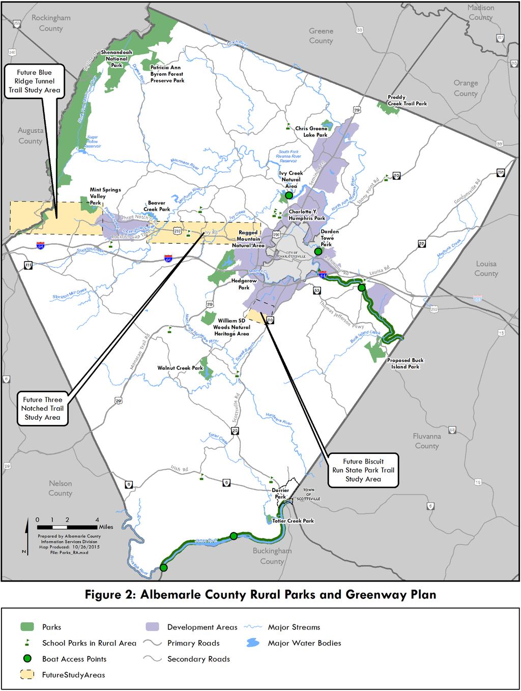
12 Strategy 2g: Continue to use County school facilities as an integral part of recreational opportunities for County residents. As mentioned earlier, playing fields for all public schools are considered public parks and are to be available for public use after schools meet their responsibilities to their students. For elementary schools, the minimum playing fields needed are those fields that serve the school s use only. When adding playing fields for parks and recreational use, it is important to know how the size and number of fields relate to pedestrian accessibility to the schools. Extra playing fields are not essential at all sites if these fields can be obtained nearby. As provided in the Community Facilities and Services Chapter, anytime a new school is constructed, the School Division and the Parks and Recreation Department should collaborate and coordinate to ensure that school, park, and recreational facilities are available. Strategy 2h: Work to make school park facilities more user-friendly. Although most of the County s small outdoor recreational facilities are located at public schools, much of the public does not know that outdoor school facilities are public parks and open to the public for use after school hours. Providing on-site information, such as signage, could help the public know that the facilities are publicly available. Working with school principals will be an important part of this activity. Objective 3: Complete the greenway trail system and provide access to blueways. Greenways are areas of vegetated open space, usually linear in nature, that connect places. They are often, though not always, located along streams and rivers, utility easements, abandoned railroads, and sometimes along roadways. Many greenways include trails but not all do. Blueways are waterways or trails along waterways that provide access to the water for boating, fishing, camping, or educational opportunities. Blueway trails, like greenway trails, help to preserve the rivers and streams along which they are developed. Figure 2 shows the locations of the County Rural Area parks and existing and proposed greenways. Figure 3 contains the Greenway Plan for the Development Areas. Standards for development and construction of greenway trails are found in the Appendix. Greenways and greenway trails have several functions. Specifically, they can: Protect important and sensitive resources. Greenway corridors preserve streamside forests and buffer areas. These areas are highly productive and diverse systems that provide many important benefits, such as improved water quality and habitat. Greenways also absorb storm runoff and prevent flood damage, recharge aquifers, and preserve the settings of natural and historic features. More information on greenways and stream buffers is in the Natural Resources Chapter. Provide recreational and educational opportunities. Greenways provide recreational opportunities, such as hiking, bicycling, fishing, picnicking, and canoeing. Also, greenways can function as living classrooms for nature studies of the life histories and behavior of plants, animals, and fish. These areas also have a great variety of birds making them favorite sites for bird watchers. Greenways increase the public s awareness of the environment. Provide an alternative transportation system. Greenways can provide pedestrian and, in some cases, bicycle connections to natural, recreational, commercial, and cultural resources. Portions of the planned greenway system are located near a large segment of the County s population, 11.12
13 11.13
14 Page intentionally left blank
15 11.15
16 Page intentionally left blank
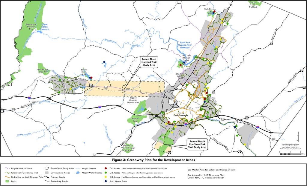
17 allowing citizens to travel by foot and bicycle instead of by automobile to parks, activity centers, and commercial areas. Greenways provide important connections between County neighborhoods, provide an excellent opportunity to promote public access to rivers and streams, and improve the overall environment of the neighborhood. Greenways can help build Albemarle County s sustainable future by connecting people and land in a manner that helps reestablish the close connections between the environment, economy, and society. Provide an economic benefit. Greenways promote the area s economy by providing attractive, outdoor places for residents and visitors. At the same time, greenways preserve environmental assets, which support eco-tourism and can increase property values. Commercial ventures, especially restaurants, can consider greenway and river-oriented locations. Greenway design could encourage trail users to come up to the shopping and commercial area and encourage shoppers to visit the river. Strategy 3a: Enhance, protect, and maintain stream and river corridor vegetation, water quality, and wildlife habitats by acquiring greenways and blueways and, in some instances, improving designated greenways by adding trails. A connected greenway system is a recreational amenity that can provide great benefits to Development Areas and Rural Area residents by making it more pleasant and easier to live in both areas. The importance of habitat and stream corridor protection is discussed in detail in the Natural Resources Chapter. Connecting the greenway system to blueways will help complete the greenway system. Strategy 3b: Continue to develop the County s greenway system as shown in the Development Area Master Plans and on the Greenway Plan. The County s existing and proposed greenway system for the Development Areas is shown on the Greenway Plan, in Figure 3. The map shows the existing 28 miles of trails and calls for building 52 more miles. In addition, the Plan shows conceptual study areas, which are places for future trails. It also shows transportation connections to other parks and trails. Since 2004, the County has added trails to the greenway system at the rate of approximately 3.5 miles per year. These greenway trails are not contiguous, but represent pieces of the larger greenway system shown on the Greenway Plan. Within public parks, there are 60 miles of continuous trails. The County has received commitments from many property owners, especially in the Development Areas, for many more miles of trails. Detailed information on elements of the Greenway Plan can be found in the Appendix to the Greenway Plan. The City of Charlottesville and Albemarle County s Parks and Recreation Departments have worked for many years to connect City and County greenways and greenway trails. Many of the City trails have been created and are maintained by the Rivanna Trails Foundation, a nonprofit organization that creates and protects footpaths, trails, and greenways within the Rivanna River watershed. Since 2004, individuals and groups have provided over 19,000 hours of volunteer labor to create and maintain the trails system. The newest greenway trail is the Old Mills Trail system in the Pantops community. This trail, located along the Rivanna River, added three miles of new trail to the system. These three miles represent the most urban and visible section of the County s greenway system. The Greenway Plan shows expected public trails and expected future pedestrian and bicycle connections in the County. A hierarchy of trail types is described in the Appendix, which describes the distinctions among tourist trails, regional trails, and neighborhood trails. Greenway trails through neighborhoods are typically owned by homeowner s associations, are privately maintained, and are 11.17
18 intended for smaller, more localized hiking and biking trips. Because they are usually only open to residents of the neighborhood in which they are located, these trails are not shown on maps for tourists. Certain trail segments within the total greenway network are considered high priority projects, so resources should initially be targeted to construct these trail segments. It is also expected that the greenway system will be built by different groups, as opportunities present themselves. Some trails will be built by the County. Trails will also be built by developers as part of development projects, by civic organizations, or by a combination of these groups. It is important to note that trail locations shown on the Greenway Plan are conceptual in nature. A trail s ultimate location may not be along a river or stream corridor due to steep slopes, soil types, sensitive resources, environmental resources, or other community concerns. Also, there may be areas identified in this section for a greenway trail that, for various reasons, do not lend themselves to trail construction. Specific guidelines on greenway and greenway trail development standards, as well as guidance on the location of future trails, bridges, connections, and access points can be found in the specific Development Area Master Plans and in the Parks, Recreation, Greenways, Blueways and Green Systems Appendix. Strategy 3c: Continue to upgrade and maintain parks and greenway trails using the resources of public and private entities. Several of the County s park facilities are being upgraded to meet ADA standards at Totier Creek Park and at several County schools. Specific expectations for these facilities are listed in the Parks and Recreation Appendix. Administrative overhead can be reduced if portions of the greenway can be maintained by private organizations. Neighborhood groups, church groups, scout troops, garden clubs, civic clubs, and other organizations may wish to participate in an Adopt-a-Greenway program to maintain a section of the greenway network. A Greenway Trail Advisory Committee, discussed later in this Chapter, is recommended to publicize greenways, to build citizens support for them, and to support citizen volunteer maintenance programs. Often, when a trail project is promoted, people assume that it will be completed in a short period of time. It is imperative that people understand that the greenway system is a long-term project. It is essential to maintain contact with local interest groups and keep them apprised of the project s status in order to cultivate support. Encouraging citizen participation in the development of the future Greenway Plan can give the community a stake in the success of the greenway system. Strategy 3d: Secure funding for greenways, greenway trails, blueways, and blueway improvements. Creating, maintaining, and constructing greenway trails and blueway improvements all require both money and volunteers. However, funding for greenways and trail development has waned in recent years, so public investment is needed through the Capital Improvement Program to ensure that the trails expected and desired by the public are constructed and maintained. Exploring and obtaining different sources of funding will help greenway trail development occur sooner rather than later
19 Strategy 3e: Set up a Greenway Trail Advisory Committee to assist the County in designing, implementing, promoting, and maintaining a greenway system. Public input, prioritization, and other direction are needed to implement a greenway trail system. For this reason, a Greenway Trail Advisory Committee is recommended. This Committee would work with various stakeholders to oversee and coordinate greenway implementation and maintenance. Implementing and maintaining a greenway system may require public-private partnerships involving many different groups and agencies. An oversight entity, such as this Advisory Committee, would assist Parks and Recreation staff in facilitating communications and coordinating activities among the agencies, organizations, and citizens groups involved. Committee membership should be representative of the many organizations with an interest in greenway trails. Membership should be diverse and contain representation from the City of Charlottesville, UVA, PVCC, the development community, landowners, running and bicycling clubs, equestrian clubs, the environmental community, civic groups, the historic preservation community, naturalists, and the business community. Also, at least one person with a background in such areas as botany, ornithology, and/or mammals should be on the committee. This Committee should assist Parks and Recreation staff to: Prioritize the various greenway projects; Determine methods to promote and fund the greenway system; Review trail plans to ensure that they are designed in a manner that adheres to agreed-upon locations and standards; Provide advice during the development process and suggest methods in which a site can connect or be integrated into the greenway system. Make recommendations to amend current zoning and subdivision regulations to facilitate implementation; Refer landowners to appropriate land trusts; be pro-active in acquiring right-of-way or donation of land for greenways; Work with the community and facilitate citizen input on trail related issues; Arrange and coordinate operation and maintenance of the greenway system with volunteers and cooperating organizations; and Establish methods to address the safety and maintenance concerns of adjacent property owners. A Greenway Trail Advisory Committee will help ensure successful construction and maintenance of the greenway system. Strategy 3f: Work with volunteers and greenway partners from the State to the local level to complete the greenway system. The process of turning a plan for the greenway system into a reality is a complex, but exciting challenge that requires a cooperative effort among many different people and organizations. While the total land area of the proposed greenway system is relatively small, its benefits will be widely felt. It is unlikely that a single entity, such as Albemarle County, will have the means to acquire and manage the extensive system proposed in this section. Therefore, the network of greenways should be coordinated 11.19
20 through a partnership effort. The greenway system is most likely to be established piece by piece by a number of groups. The Greenway Trail Advisory Committee should coordinate the activities of the partners in implementing the greenway system. Strategy 3g: Continue to encourage developers to contribute to the greenway system by dedicating land, donating easements or funds, and/or constructing portions of the trails identified on the Greenway Plan. Developers may increase the marketability of their developments and provide amenities by contributing to the greenway system. Protected scenic views and trails in wooded areas or near streams are valuable amenities; economic studies indicate that such amenities increase the value of the development. During the development review process, staff should make applicants aware of proposed greenway locations, and seek, through dedication, donation, or open space easement, the preservation of these corridors and the development of trails. Strategy 3h: Continue to demonstrate the benefits and values of greenways to individual landowners whose land, or parts thereof, could be made a part of the greenway system through donation of the land or an easement. The County rarely purchases land specifically for greenways. As a rule, the greenway system is developed on donated land. For this reason, staff should continue to work with landowners to provide information on the County s proposed greenway system and how an individual property may contribute to that system. Landowners can provide greenway land through a variety of voluntary methods. The most common way is a conservation easement. Easements may provide permanent protection and may be tailored to the landowner s needs and wishes. Also, landowners may wish to donate or sell their land for the establishment of the greenway. Strategy 3i: Increase public awareness of greenways and provide educational opportunities, such as nature hikes, species and plant identification, and interpretation of historic, architectural, and natural resources. Local awareness of and interest in the development of a greenway system is critical to its success. Promotion and marketing are key ingredients of a successful greenway system. To help increase community awareness of the existing and planned segments, it is important to provide a brochure with maps, trail lengths, photographs, directions, and park logos. This resource can be useful with regular events on the trail, such as nature walks, bird watching trips, trail and river clean-up days, photo competitions, and walk-a-thons. Strategy 3j: Coordinate adjacent land development with the greenway, so that existing and future development can be integrated into and harmonious with the greenway system. Greenway trail sections are often built at different times, such that trail segments on adjoining parcels may not connect for many years. However long it will take, it is important to plan ahead for trail development. In particular, attention is needed to the ways in which people will access greenway trails and what can be seen along a greenway trail. For example, if a greenway trail is proposed next to a commercial development that will have a tall retaining wall or stormwater outfall, the result may be an uninviting section of trail. In addition, new and existing residential and nonresidential developments should consider providing internal trails that link their development to an adjoining greenway
21 Strategy 3k: Improve the functionality of Greenway Plan maps so that they are more accessible to the public and can be more easily understood. Greenways in Albemarle County are valuable asset; however, clear maps of greenways are not currently available. Such maps are difficult to create because of the large land area covered by greenways, especially in the Rural Area. In addition, a map showing County parks, school parks, trails that connect to transportation systems, and specific trail segments is difficult to read because it shows multiple layers of information that can be confusing. A better way to illustrate greenways is needed for both the public and for the Comprehensive Plan. Coordination with the staff working on the transportation plan and County-owned stormwater facilities will be important to help create a comprehensive, yet functional Greenways Plan map. Objective 4: Provide access points to greenways and blueways. Reliable and frequent access to greenways is important to ensure safety and constant use of facilities. Constant use helps to reduce maintenance because walkers are able to keep weeds down and notify maintenance workers of trail maintenance issues before they become problems. Public access to blueways helps to keep boaters from trespassing on private property. Planned access points for both greenways and blueways are provided in the Appendix. Strategy 4a: Provide access to public greenways at locations shown in Development Area Master Plans and in places listed in the Greenway Plan. Access points are important because they make it possible for residents and visitors to get to community destinations by trail. Details on expected locations are provided in the Appendix. Neighborhood connections are important so residents can access trails that lead from their neighborhood to key places in the community. Access points for the larger community can become destinations for tourists, such as the Old Mills Trail along the Rivanna River. A hierarchy of trail access points exists for the trails identified in the Appendix. Strategy 4b: Provide boat access at appropriate locations along the Rivanna River, the Rivanna Reservoir, and the James River. Target access or improvements to access points at the locations listed in the Greenway Plan. Details are provided in the Appendix to this Plan. Many residents enjoy boating on the County s rivers; however, parking areas at access points are very limited. Safe boat access to the Rivanna Reservoir is needed to help alleviate the unmanaged and unsafe access currently in use. In some cases, the safety of boat launches is very poor. A plan for better maintenance of public boat launches and adjacent parking areas is needed. Objective 5: Provide bicycle and pedestrian connections from City and County parks and schools in the Development Areas to neighborhoods, employment centers, shopping areas, public parks, and public schools. The Neighborhood Model emphasizes the need to connect important places with sidewalks and bicycle paths. These paths can make it possible to walk to schools, parks, and other important places
This page intentionally blank.
 This page intentionally blank. Parks, Recreation, and Open Space Chapter Relationship to Vision Vision Parks, Recreation and Open Space Chapter Concepts County Government. County government that is accountable
Living in Albemarle County s Urban Places
 Living in Albemarle County s Urban Places ALBEMARLE COUNTY, VIRGINIA A Closer Look at Albemarle s Approach to Managing Growth and Creating Quality Urban Environments www.albemarle.org Page 2 Living in
OPEN SPACE CHAPTER 7: OVERVIEW. Preserve open space to protect natural resources, enhance character and provide passive recreation opportunities
 CHAPTER 7: OPEN SPACE OVERVIEW Ridgefield has made tremendous progress permanently preserving areas of town as open space. Open space preservation can serve many important purposes, including: protect
Town of Peru Comprehensive Plan Executive Summary
 Town of Peru Comprehensive Plan Executive Communities that plan grow by choice, not by chance. A plan makes growth thoughtful, understandable, and predictable. A plan shows that a community is managing
Preface. Erie. Scranton. Allentown. Pittsburgh. Harrisburg. Philadelphia
 The Southern Alleghenies Region The Southern Alleghenies Region spans the Laurel Highlands and Allegheny Front in the west across the Appalachians to the east. It is comprised of Blair, Bedford, Cambria,
Support the implementation of Cape Coral's Comprehensive Plan. Protect and utilize the unique natural resources in the City.
 7.0 OVERVIEW - RECOMMENDATIONS Chapter 7 The preparation of the Cape Coral Parks and Recreation Master Plan spanned a period of approximately 12 months. Plan preparation included the input of a wide range
Provide and maintain sufficient public parks, recreation facilities, and open space to meet the recreational needs of County residents and visitors.
 (ROS) Goal Provide and maintain sufficient public parks, recreation facilities, and open space to meet the recreational needs of County residents and visitors. OBJECTIVE ROS.01 The County shall acquire,
Source: Albemarle County Community Development 2010
 Source: Albemarle County Community Development 2010 GROWTH MANAGEMENT GOAL: Albemarle County s Development Areas will be attractive, vibrant areas for residents and businesses, supported by services, facilities,
The urban parks in Charlottesville include Jackson Park, Lee Park, and McGuffey Park.
 Park Classifications Charlottesville s parks can be grouped into 4 different classifications: urban parks, neighborhood parks, community parks, and regional parks. Figure 1 on page 5 inventories the facilities
1. Parks & Recreation Neighborhood Parks Community Parks Special Use Sites 2. Open Space 3. Trails
 Appendix A: Park Classifications The intent of parks and recreation classifications is to aid in making acquisition and design decisions for park sites, facilities and the organization of recreation space
3. VISION AND GOALS. Vision Statement. Goals, Objectives and Policies
 Vision Statement Queen Creek s interconnected network of parks, trails, open spaces and recreation opportunities provide safe and diverse activities and programs that sustain its unique, small town, equestrian
BROOKHILL NEIGHBORHOOD MODEL ZONING MAP AMENDMENT PREFACE TO APPLICATION
 BROOKHILL NEIGHBORHOOD MODEL ZONING MAP AMENDMENT PREFACE TO APPLICATION June 15, 2015 Revised: August 1, 2016 I. VISION Brookhill is a proposed community based upon the principles of Albemarle County
Mendota Heights 2040 Comprehensive Plan Draft Vers
 4 Parks and Trails The City of Mendota Heights boasts a variety of recreational and open space opportunities. Few cities can claim access to regional trails, riverside and lakeside parks, scenic bluffs
Parks, Open Space and Trails
 Introduction Parks have often been referred as the lungs of our cities, cleansing the air of pollutants and particulate matter. Parks are also gathering places for families and community. They offer spaces
10.0 Open Space and Public Realm
 10.0 Open Space and Public Realm 10.0 Open Space and Public Realm The Public Open Space System is comprised of: outdoor spaces available for public use that are either publicly owned (e.g., parks and
EL DORADO COUNTY GENERAL PLAN PARKS AND RECREATION ELEMENT PRINCIPLE INTRODUCTION STATE AUTHORIZATION
 EL DORADO COUNTY GENERAL PLAN PARKS AND RECREATION ELEMENT PRINCIPLE The General Plan must identify the types of governmental services, including parks and recreation facilities, which are necessary to
The following principles guide the development of goals and strategies to protect and promote these amenities:
 OPEN SPACE/PARKS/TRAILS/RECREATION GOALS/STRATEGIES Cherry Hills Village is a living environment that offers low density development, open areas, public scenic vistas, public trails and public parks. This
Additional information about land use types is given in Chapter 5. Design guidelines for Centers and Neighborhoods are given in Chapter 7.
 4. Place Types Introduction In Albemarle County s Development Areas, the Neighborhood is the fundamental unit of community planning. The County s Neighborhood Model, an adopted part of the Comprehensive
Section 4 BUILDING THE MASTER PLAN
 The Master Plan 33 Section 4 BUILDING THE MASTER PLAN Figure 4:1. A collaborative effort characterized the two design workshops sponsored by DISC to create hypothetical Master Plans for the Towers Property
City of Nogales General Plan
 Open Space, Parks, Recreation and Trails City of Nogales General Plan Residents of Nogales place a high priority in the development of a comprehensive system of open space, parks, recreation and trails
Comprehensive Plan ADOPTED APRIL 2014
 Comprehensive Plan ADOPTED APRIL 2014 8 8. Outstanding Recreational & Cultural Opportunities We are proud of our community s parks and recreation system. Our community will ensure that the legacy of our
RECREATION AND OPEN SPACE ELEMENT GOALS, OBJECTIVES, AND POLICIES
 RECREATION AND OPEN SPACE ELEMENT GOALS, OBJECTIVES, AND POLICIES Goal 7 To provide park facilities, recreation programs, and open space resources that are safe, adequate, and accessible to all City residents,
PARTF Scoring System for Grants
 PARTF Scoring System for Grants The members of the N.C. Parks and Recreation Authority use the PARTF scoring system as one of several tools to select grant recipients. Please provide all of the information
RECREATION, OPEN SPACE AND GREENWAYS ELEMENT GOALS, OBJECTIVES, AND POLICIES
 RECREATION, OPEN SPACE AND GREENWAYS ELEMENT GOALS, OBJECTIVES, AND POLICIES GOAL R-1: DEVELOP A RECREATION, OPEN SPACE AND GREENWAYS SYSTEM AS AN INTEGRAL COMPONENT OF AN OVERALL, COUNTY-WIDE ECONOMIC
RECREATION AND OPEN SPACE VISION
 City of South Lake Tahoe General Plan Policy Document Recreation and Open Space Element INTRODUCTION This element provides the policy context for the City of South Lake Tahoe to achieve its vision for
Section 3 INVENTORY OF RECREATION LAND AND FACILITIES
 Photo of Juan Bautista de Anza Park Section 3 INVENTORY OF RECREATION LAND AND FACILITIES Summary of Findings Park Definitions Summary of Recreation Facilities Other Recreation Facilities Nearby Recreation
G. RECREATION AND OPEN SPACE ELEMENT. The following summarizes the Recreation and Open Space Element:
 G. RECREATION AND OPEN SPACE ELEMENT The purpose of the Element is to provide the framework and direction for a comprehensive system of public and private sites for recreation, including, but not limited
Chapter 5: Natural Resources and Environment
 NATURAL RESOURCES AND ENVIRONMENT 5-1 5 Chapter 5: Natural Resources and Environment BACKGROUND AND INTENT Urban expansion represents the greatest risk for the future degradation of existing natural areas,
Biscuit Run Gateway. TJPDC staff recommends combining the following projects:
 Biscuit Run Gateway I. Summary: The Thomas Jefferson Planning District Commission recommends that the Metropolitan Planning Organization Policy Board vote to combine several existing projects on the Long
Draft Stillwater 2030 Comprehensive Plan- Goals and Policies
 Draft Stillwater 2030 Comprehensive Plan- Goals and Policies Instructions- Review each goal and policy and discuss with group any changes, deletions for additions to the list using your groups pen. Keep
Yadkin River Greenway Feasibility Study Fact Sheet Village of Clemmons, Town of Lewisville, Town of Bermuda Run
 Fact Sheet Village of Clemmons, Town of Lewisville, Town of Bermuda Run Project Background The Yadkin River Greenway Feasibility Study is a joint project with the Village of Clemmons, the Town of Bermuda
PARKS. Chapter Introduction
 Chapter 4. PARKS 4.1. Introduction This Parks Element of the 2016 Comprehensive Plan Update provides direction and guidance, based on citizen input, in order to improve and maintain the City s existing
6. RECREATION AND OPEN SPACE ELEMENT
 6. RECREATION AND OPEN SPACE Introduction This Recreation and Open Space Element includes Goals, Objectives and Policies (GOP) that apply to the main campus in Gainesville and the Lake Wauburg Recreation
RECREATION AND OPEN SPACE ELEMENT
 RECREATION AND OPEN SPACE ELEMENT Last amended August 19, 2008 Table of Contents Objective Page 5.1 Park system defined... 5-1 5.2 Access to parks and recreational facilities... 5-2 5.3 Recreation and
The transportation system in a community is an
 7 TRANSPORTATION The transportation system in a community is an important factor contributing to the quality of life of the residents. Without a sound transportation system to bring both goods and patrons
CHAPTER 7: Transportation, Mobility and Circulation
 AGLE AREA COMMUNITY Plan CHAPTER 7 CHAPTER 7: Transportation, Mobility and Circulation Transportation, Mobility and Circulation The purpose of the Transportation, Mobility and Circulation Chapter is to
Chapter 5: Recreation
 Chapter 5: Recreation Introduction and Setting Recreational opportunities within Nevada County are varied, ranging from public parks with intensively used active recreational facilities, to vast tracts
Planning Academy MARCH 8, 2015
 Planning Academy MARCH 8, 2015 Overview of Growth Management in Albemarle County Comprehensive Plans, Planning Initiatives Major Milestones Key Policies History Comprehensive Plan should precede Zoning
Executive Summary Purpose of the Plan Defining Open Space and Greenways
 Executive Summary Bucks County possesses a vast array of open space resources including natural areas, parks, farmland and historic and cultural resources that contribute to a high quality of life valued
OPEN SPACE AND RECREATION
 OPEN SPACE AND RECREATION The Town celebrates and maintains the spectacular visual character of our Sonoran Desert setting and we value our open space, mountain views, washes, vegetation, and wildlife.
13 Maintenance and Operations Plan 223
 222 13 Operations Maintenance and Plan 223 Chapter 13 MAINTENANCE AND OPERATIONS PLAN 13.1 Stewardship The Minneapolis Park and Recreation Board (MPRB) is the steward of a nationally-acclaimed park system.
Concord Community Reuse Project Goals and Guiding Principles. Overarching Goals (OG)
") Concord Community Reuse Project Goals and Guiding Principles Overarching Goals (OG) No priority is implied by the order of presentation of the goals and guiding principles. Overarching goals for the Concord
Concord Community Reuse Project Goals and Guiding Principles Overarching Goals (OG) No priority is implied by the order of presentation of the goals and guiding principles. Overarching goals for the Concord
Master Plan Workshop October 25, 2007 Charlotte Mecklenburg Government Center
 Master Plan Workshop October 25, 2007 Charlotte Mecklenburg Government Center Land Discussion 1. What are the most important land related issues we need to address? Protect natural areas Passive walking
GOALS, OBJECTIVES, POLICIES & PROGRAMS
 Chapter 5 GOALS, OBJECTIVES, POLICIES & PROGRAMS 5.1 Goals, Objectives, Policies & Programs This is a joint plan adopted by both the Village of Waunakee and the Town of Westport. Both communities will
SEWRPC OUTDOOR RECREATION AND OPEN SPACE PLANNING OBJECTIVES, PRINCIPLES, AND STANDARDS
 SEWRPC OUTDOOR RECREATION AND OPEN SPACE PLANNING OBJECTIVES, S, AND STANDARDS Introduction The Southeastern Wisconsin Regional Planning Commission (SEWRPC), as part of the regional park and open space
Secrest Short Cut and Monroe Expressway Small Area Plan AUGUST 29, 2018
 Secrest Short Cut and Monroe Expressway Small Area Plan AUGUST 29, 2018 Background and Process Monroe Expressway will be open by the end of 2018 Union County and Indian Trail identified a need to revisit
Master Plan Objectives and Policies
 Master Plan Objectives and Policies Introduction This chapter identifies the Park issues and recommended policies established by this Master Plan. The issues were identified through meetings with staff,
Arlington, Virginia is a worldclass
 EXECUTIVE S U M M A RY Arlington maintains a rich variety of stable neighborhoods, quality schools and enlightened land use policies, and received the Environmental Protection Agency s highest award for
ARTICLE 6: Special and Planned Development Districts
 ARTICLE 6: Special and Planned Development Districts 6-10 Traditional Neighborhood Development (TND) District 6-10.10 Purpose and Intent The Traditional Neighborhood Development (TND) District provides
The City shall enhance and improve the accessibility of parks and recreational facilities while protecting their quality. by:
 GOALS, OBJECTIVES AND POLICIES GOAL 1: To provide open space and recreation as an essential element needed for the betterment of the City s character and quality of urban life. The City shall plan for
The Five Components of the McLoughlin Area Plan
 The Five Components of the McLoughlin Area Plan This documents contains the complete language of the five components of the McLoughlin Area Plan: The Vision Statement The Values The Guiding Principles
BISCUIT RUN PARK MASTER PLAN
 BOARD OF SUPERVISORS November 14, 2018 BISCUIT RUN PARK MASTER PLAN COUNTY OF ALBEMARLE ANHOLD ASSOCIATES Contents Project Introduction Property Background County Park Planning Process Existing Site &
Parks, Trails, and Open space Element
 Parks, Trails, and Open space Element Parks, Trails, and Open Space element Parks, Recreation, and Open Space are important components of the quality of life desired by the residents of Elk Grove. This
City of Hermosa Beach Administrative Policy #
 City of Hermosa Beach Administrative Policy # SUBJECT: Living Streets Policy Date: Approved by: City Council Authority: Public Works Department & Community Development Department Mayor, PURPOSE The City
V. Vision and Guiding Principles
 V. Vision and Guiding Principles The Master Plan for the Powers Ferry Corridor seeks a foundation in the desires of the community. At times, various elements of the community offered opposing viewpoints,
SECTION FOUR: MISSION STATEMENT, GOALS & OBJECTIVES
 SECTION FOUR: MISSION STATEMENT, GOALS & OBJECTIVES Chapter Summary Chapter Ten: Mission Statement, Goals & Objectives To fulfill its mission, the Parks and Recreation Commission has identified four basic
Courthouse Planning Area
 Courthouse Planning Area Current Reality The Courthouse Planning Area is the characterized by expansive suburbanscale residential areas as well as the community resource planned area of athletic, educational,
Midtown Greenway Land Use and Development Plan Executive Summary
 Midtown Greenway Land Use and Development Plan Executive Summary Introduction The Midtown Greenway Land Use and Development Plan sets policy direction for land use and development in the Midtown Greenway
A Vision for Walnut Creek
 A Vision for Walnut Creek Photo: City of Clive Walnut Creek Booklet 8 of 8 Greater Des Moines Water Trails and Greenways 1 Table of Contents Booklet 1: Water Trails Strategies and Policies Booklet 2: Beaver
Chapter 2: Vision, Goals and Strategies
 Chapter 2: Vision, Goals and Lake Elmo Today & Tomorrow Comprehensive Plan 2040 2 VISION, GOALS & STRATEGIES - DRAFT 4-6-2018 INTRODUCTION Comprehensive Plan Purpose Perhapse the most important objective
STAFF RECOMMENDATION: Adopt the Parks and Recreation Master Plan 2013, or take other action as deemed appropriate.
 Regular 7. CITY COUNCIL AGENDA Meeting Date: 12/02/2013 TITLE: Parks and Recreation Master Plan 2013 Adoption Proposal - Dwight Curtis Responsible Staff: Dwight Curtis Backup Material: Backup material
LAND USE ELEMENT. Purpose. General Goals & Policies
 LAND USE ELEMENT Purpose This Land Use Element contains the goals and policies necessary to support the City s responsibility for managing land resources and guiding development through implementing regulations,
ATTACHMENT A AERIAL PHOTO OF McINTIRE PARK EAST
 ATTACHMENT A AERIAL PHOTO OF McINTIRE PARK EAST McIntire Botanical Garden Request for Proposals Attachments Page 1 of 33 ATTACHMENT B - MEMORANDUM OF AGREEMENT WITH THE CITY OF CHARLOTTESVILLE McIntire
DRAFT FOR PUBLIC REVIEW. Game Plan for a Healthy City
 DRAFT FOR PUBLIC REVIEW 2018 Game Plan for a Healthy City 2 Denveright. Parks & Recreation Game Plan Draft for Public Review Draft for Public Review Executive Summary Game Plan Overview Executive Summary
Silverdale Regional Center
 Silverdale Regional Center Vision for Silverdale Regional Center The Silverdale Regional Center Plan (Plan) will guide the evolution of the Silverdale Regional Center from a collection of strip malls and
PARKS AND RECREATION
 PARKS AND RECREATION WHAT YOU WILL FIND IN THIS CHAPTER: Background information on the development of the Park, Recreation, and System Plan (PRSP). General overview of Ellensburg s parks and recreation
Objectives and Strategies for the Integration of Recreation, Parks and Open Space in Regional Plans
 BULLETIN 2 Objectives and Strategies for the Integration of Recreation, Parks and Open Space in Regional Plans TABLE OF CONTENTS Introduction 3 Land-use Framework Outcomes 1 4-8 Land-use Framework Outcomes
CHAPTER 4 FUTURE LAND USE AND URBAN SERVICES DISTRICTS
 CHAPTER 4 FUTURE LAND USE AND URBAN SERVICES DISTRICTS Introduction This chapter discusses how Benzie County should grow and change in the future. A community can grow and change in many different ways.
Parks, Trails, and Open Space Element
 P arks, Recreation, and Open Space are important components of the quality of life desired by the residents of Elk Grove. This Element of the General Plan addresses the City s goals, policies, and actions
Appendix 4 Park, Trail, and Recreation Facilities For more information, call the Park Planning and Stewardship Division at
 Appendix 4 Park, Trail, and Recreation Facilities For more information, call the Park Planning and Stewardship Division at 301-650-4380 montgomery county planning board maryland-national capital park and
2040 LUP is a part of the Comprehensive Plan and carries the same legal authority. Economic Challenges
 1.1. Guiding Anchorage s Growth Where will new residents settle over the next two decades? Where will people work, shop, and play? Will there be enough room to grow? How will Anchorage look? Will growth
TOWN OF BETHLEHEM OPEN SPACE CONSERVATION PLAN PUBLIC MEETING: OCTOBER 12, 2017
 TOWN OF BETHLEHEM OPEN SPACE CONSERVATION PLAN PUBLIC MEETING: OCTOBER 12, 2017 Welcome and Agenda 6:00 6:45: Open House, Part One 6:45 7:15: Presentation and Questions 7:15 8:00: Open House, Part Two
STEWARDSHIP OF LONG ISLAND SOUND S ECOLOGICAL AND RECREATIONAL RESOURCES
 STEWARDSHIP OF LONG ISLAND SOUND S ECOLOGICAL AND RECREATIONAL RESOURCES Robin Kriesberg, Save the Sound, Inc. Thomas Halavik, US Fish and Wildlife Service Coastal Program An Initiative to Identify, Protect
City Council March 27, Parks, Recreation, and Trails Master Plan
 City Council March 27, 2018 Parks, Recreation, and Trails Master Plan Planning Process Develop Goals and Objectives Inventory of Areas and Facilities Needs Assessment And Identification Public Participation
Throughout. square. (Crystal City Vision Plan 2050)
") 1: Terms related to the PSMP document 1 public space (see also public realm, civic space) An open space designated on the regulating plan, accessible to all, including Plazas, Mini Parks, and Neighborhoods
1: Terms related to the PSMP document 1 public space (see also public realm, civic space) An open space designated on the regulating plan, accessible to all, including Plazas, Mini Parks, and Neighborhoods
SECTION II SECTION II STATEMENT OF GOALS, OBJECTIVES, PRINCIPLES, ASSUMPTIONS, POLICIES AND STANDARDS
 STATEMENT OF GOALS, OBJECTIVES, PRINCIPLES, ASSUMPTIONS, POLICIES AND STANDARDS 1 2 STATEMENT OF GOALS, OBJECTIVES, PRINCIPLES, ASSUMPTIONS, POLICIES AND STANDARDS INTRODUCTION The New Jersey Municipal
Green Infrastructure The Indianapolis Greenways Connection
 Green Infrastructure The Indianapolis Greenways Connection Fewer things in the transportation industry today make better since than combining the needs for pedestrian and bike trails with the need to locate,
Chapter 6. Overall Vision RECOMMENDATIONS. More Trail and Trail. Connections. Equal Access to Park. Facilities and Programs. Water Access.
 Overall Vision More Trail and Trail Connections Equal Access to Park Facilities and Programs Water Access Environment Variety Chapter 6 RECOMMENDATIONS Chapter 6 The following recommendations for park,
COMMUNITY DESIGN. GOAL: Create livable and attractive communities. Intent
 COMMUNITY DESIGN Intent An attractive, well-designed County will attract quality development, instill civic pride, improve the visual character of the community, and create a strong, positive image for
DRAFT Amsterdam/Churchill Community Plan (4/17/08) Adopted By the Gallatin County Commission
 Adopted By the Gallatin County Commission") DRAFT Amsterdam/Churchill Community Plan (4/17/08) Adopted By the Gallatin County Commission Table of Contents Acknowledgements Chapter 1: Introduction A Brief History What s Next Authority Organization
DRAFT Amsterdam/Churchill Community Plan (4/17/08) Adopted By the Gallatin County Commission Table of Contents Acknowledgements Chapter 1: Introduction A Brief History What s Next Authority Organization
Implementation Vision
 Introduction The implementation chapter is the how to portion of the plan. It describes the actions necessary to realize the visions presented in this document through the goals, objectives, and policies
CHAPTER 8 ISSUES, CONCERNS, CONSTRAINTS AND OPPORTUNITIES
 CHAPTER 8 ISSUES, CONCERNS, CONSTRAINTS AND OPPORTUNITIES Introduction This River Conservation Plan was developed during a time of tremendous activity and effort in planning the transformation of the Delaware
Green Infrastructure Policies and Ordinances
 Green Infrastructure Policies and Ordinances October 23, 2013 By Karen Firehock, Green Infrastructure Center 2013 Georgia Urban Forest Council s 23 rd Annual Conference The mission of the nonprofit Green
Ten Mile Creek Planning Area
 PLANNING AREA POLICIES TEN MILE CREEK Ten Mile Creek Planning Area Location and Context The Ten Mile Creek Planning Area ( Ten Mile Creek area ) is located south of the current Boise AOCI, generally south
The Illinois Department of Transportation and Lake County Division of Transportation. Route 173, including the Millburn Bypass
 The Illinois Department of Transportation and Lake County Division of Transportation welcome you to this Public Hearing for U.S. Route 45 from Illinois Route 132 to Illinois Route 173, including the Millburn
Land Use. Chapter 8: Introduction. Land Use Vision. Section I: Current Land Use 8-1
 Introduction Land use is the defining element of the comprehensive plan. It will serve as a framework for decision makers, guiding future growth and development in the Town of Oconto Falls. This chapter
SALISBURY TOMORROW Our Vision
 SALISBURY TOMORROW Our Vision Salisbury is committed to supporting a high quality of life and sense of community for all residents. These commitments need to be reflected in our community programs, services
Appendix D OUTDOOR RECREATION AND OPEN SPACE PLANNING OBJECTIVES, PRINCIPLES, AND STANDARDS FOR WASHINGTON COUNTY
 Appendix D OUTDOOR RECREATION AND OPEN SPACE PLANNING OBJECTIVES, S, AND FOR WASHINGTON COUNTY OBJECTIVE NO. 1 The provision of an integrated system of public -use outdoor recreation sites and related
North Oakville East Parks Facilities Distribution Plan. November, 2009
 North Oakville East November, 2009 POLICY CONTEXT 1) Purpose a) The purpose of this document is to be a guide for the location, configuration, design and development of the parks system for the North Oakville
CHAPTER 1 Introduction
 CHAPTER 1 Introduction From sea to summit, Lane County covers almost 4,800 square miles of diverse Oregon landscape. Stretching from the Pacific Ocean through the Coastal Range, the Willamette Valley to
Citizen s Advisory Committee
 Citizen s Advisory Committee 13 Members 6 Meetings (5 Locations) 1 Public Meeting Numerous Report Drafts Countless Hours of Review Immeasurable Input Special Thank You To: Jack Cohen Brian Kile George
SUSTAINABILITY PLAN OTTAWA COUNTY PARKS AND RECREATION COMMISSION FALL 2017
 SUSTAINABILITY PLAN OTTAWA COUNTY PARKS AND RECREATION COMMISSION FALL 2017 Table of Contents Introduction Natural Resources Quality of Life Community Continuing the Mission Sustainability Measuring Sustainability
Neighborhood Four. Location. Existing Land Use. Environmental Characteristics
 Neighborhood Four Location Neighborhood Four is bounded on the east by Route 20, Route 53 and the eastern portion of the Blue Ridge Hospital property, on the south by a stream tributary to Biscuit Run
Northeast Quadrant Plan
 Northeast Quadrant Plan Northeast Quadrant Distinctive Features Land Use The Northeast Quadrant includes all the area within the planning area that is east of Interstate 5 and to the north of State Route
Planning for and Managing Open Space and Natural Areas
 Planning for and Managing Open Space and Natural Areas Increasingly, development proposals in Delaware include large amounts of open space and natural areas. While open space is important as a community
Open Space, Natural Areas, Parks, and Recreation
 Open Space, Natural Areas, Parks, and Recreation WHAT ARE THE CITY S CURRENT VALUES? This section addresses open spaces, natural areas, parks and recreation, and stormwater multi-use projects under separate
Plano Tomorrow Vision and Policies
 Plano Tomorrow Vision and Policies PLANO TOMORROW PILLARS The Built Environment The Social Environment The Natural Environment The Economic Environment Land Use and Urban Design Transportation Housing
GENERAL LAND USE PLAN ELEMENT
 CITY OF Prepared by City of Medford Planning Department 200 South Ivy Street Medford, Oregon 97501 plnmed@ci.medford.or.us James E. Huber, AICP, Planning Director COMPREHENSIVE PLANNING SECTION John Adam,
Little Neck Planning Area
 Little Neck Planning Area Current Reality The Little Neck Planning Area is characterized by established residential neighborhoods, Town Center and Pembroke. The Eastern and Western Branches of the Lynnhaven
North Fair Oaks Community Plan Summary and Information
 North Fair Oaks Community Plan Summary and Information WHAT IS THE NORTH FAIR OAKS COMMUNITY PLAN? The North Fair Oaks Community Plan is part of the San Mateo County General Plan, and establishes policies