SUBFY2016-1/ZONFY2016-1: Preliminary Plat with Planned Unit Development and Rezone
|
|
|
- Robert Burke
- 5 years ago
- Views:
Transcription


1 P a g e 1 CITY OF GARDEN CITY 6015 Glenwood Street Garden City, Idaho Phone 208/ Fax 208/ SUBFY2016-1/ZONFY2016-1: Preliminary Plat with Planned Unit Development and Rezone For: Parkway Station Subdivision Located at 4232 Adams Street and 418 & nd Street, Garden City, Idaho Applicant Parkway Station LLC Garden City Planning and Zoning Commission PUBLIC HEARING DATE: February 17, 2016, at 6:30 p.m. Staff Contact: Jeff Lowe (208) ; planning@gardencityidaho.org CONTENTS Staff Report Application Materials Findings of Fact, Conclusions of Law, Draft Decision SUBFY2016-1: Parkway Station Subdivision

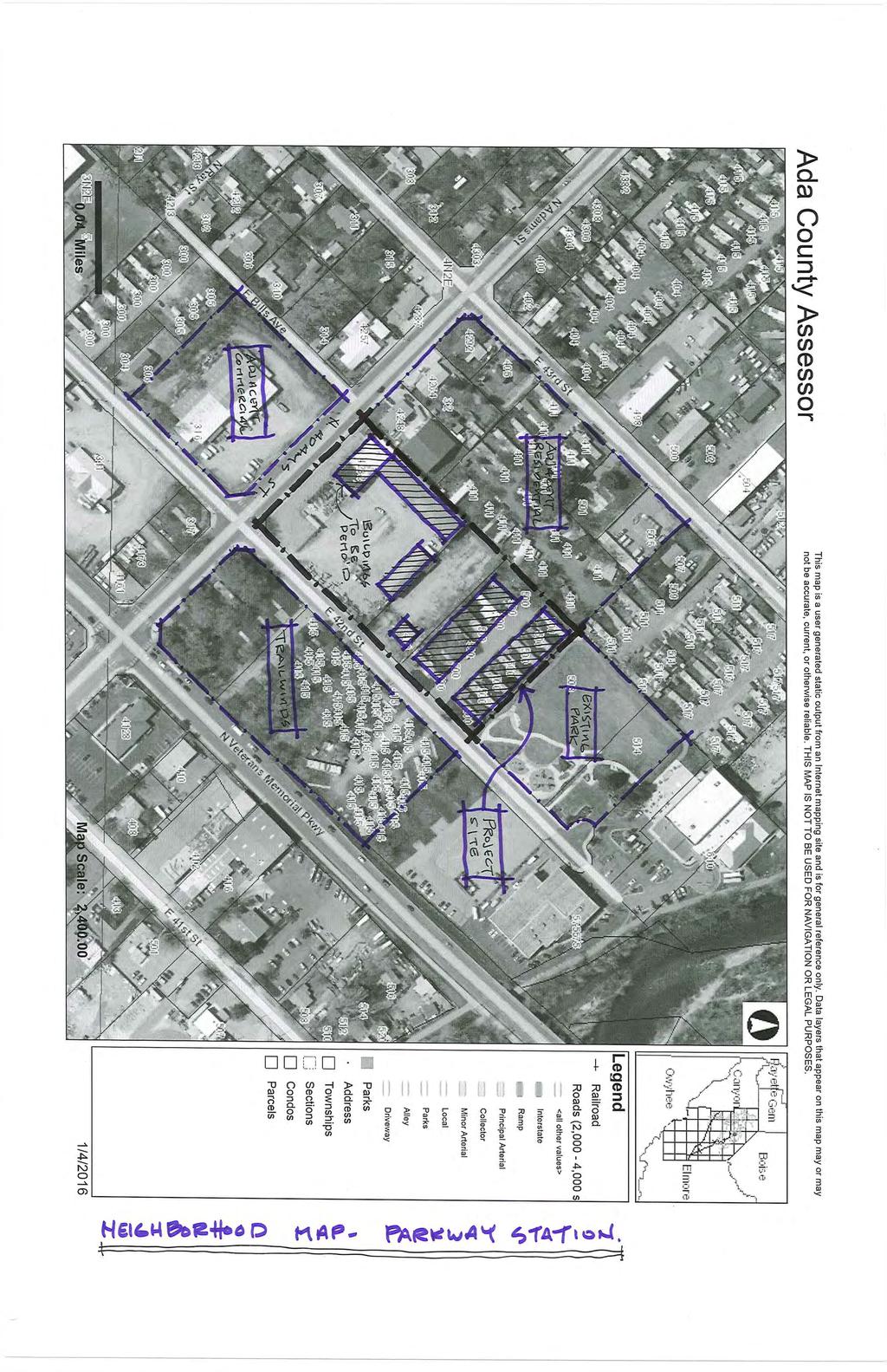
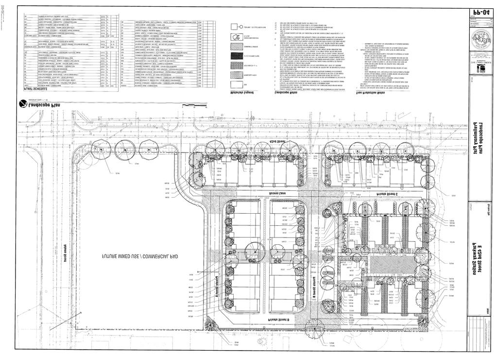
2 P a g e 2 Project Description: Hearing Date: February 17, 2016, at 6:30 p.m. Application: SUBFY2016-1/ZONFY Applicant: Parkway Station, LLC Location: 4232 Adams Street and 418 & nd Street, Garden City, ID Assigned Ada County Parcel #s: R , R , R Project Synopsis: This is an application for a Rezone from C-2 (General Commercial Zoning District) to M (Mixed Use Zoning District), preliminary plat, and planned unit development approval for Parkway Station Subdivision. The proposed development consists of 50- lots (41-buildable for residential units, 8- common, and 1-mixed use). The acre site is located on the northwest corner of 42nd and Adams Streets and is within the Mixed Use Residential and Transit Oriented Development Comprehensive Plan designations. The proposed density of the development is equivalent to ten (10) dwelling units per acre overall and approximately 16 (15.8) dwelling units per acre for the portion of the site proposed for residential. City of Garden City Planning and Zoning Commission Staff Report Existing Conditions: The proposed subdivision is to be located on parcels currently occupied by a manufactured home park, storage, office, and a few trees. Portions of the site are paved while the remainder is predominantly graveled. Property Size: 4.07 acres Zoning: C-2 (General Commercial Zoning District) and M (Mixed Use Zoning District) Comprehensive Plan Designation: Mixed Use Residential and Transit Oriented Development Flood Plain Designation: Not in Floodplain Surrounding Uses: single-family dwellings, multi-family, Riverfront Park/Boys and Girls Club, warehouse Existing Use: manufactured home park, storage, office Garden City Easements: none documented on-site. There are eighteen trees on the site, no notable plant or animal species have been identified. SUBFY2016-1: Parkway Station Subdivision
3 P a g e 3 Recommendation: Approval with Conditions Standards for Review: Standards for review of this application are as follows: 8-5A-4 GENERAL STANDARDS: A. All subdivisions, and all improvements and facilities constructed as part of a subdivision, shall comply with the provisions set forth in this Chapter; and with the minimum development standards set forth in other provisions of the GCC as follows: Table 8-5A-1 STANDARDS AND CODE SECTION PROVISIONS* Standards Staff Analysis of Compliance Design Review Title 8-Chapter 4, Articles B. and C. Compliant with conditions Driveways Title 8- Chapter 4, Article E. Compliant Erosion Control Title 4-Chapter 15 Required Floodplain Title 8-Chapter 3, Article B. N/A Landscaping Title 8-Chapter 4, Article I. Compliant with conditions Open Space Title 8-Chapter 4, Article L Compliant with conditions Parking Title 8-Chapter 4, Article D Compliant with PUD Planned Unit Development Title 8-Chapter 6, Article B. Compliant with conditions Private Streets Title 8-Chapter 4, Article E. N/A - considered Common Driveway Public water and sewer systems Title 6 Condition of approval Sidewalks Title 8-Chapter 4, Article E. Compliant Storm drainage and erosion control Title 4-Chapter 14 Compliant with conditions Sustainable Development Provisions Title 8-Chapter 4, Article G. Compliant Utilities Title 8-Chapter 4, Article A. Compliant with conditions Comprehensive Plan Analysis Compliant Comments from Other Departments and Agencies Compliant with conditions * Table reformatted Staff Analysis 8-2B BASE ZONING DISTRICT PROVISIONS: Compliant Single-family and Multi-family homes are a permitted use in the C-2 and M Zoning Districts. Comp Plan Designation Zoning District Land Use Existing Mixed Use Res. and TOD C-2 and M Mobile home park / office / storage Proposed No Change M Mixed Use Mixed Use development North of Site Mixed C-2 - General Commercial Riverside Park South of Site Mixed Use Res. and TOD C-2 - General Commercial Adams Street/warehouse East of Site Mixed Use Res. and TOD C-2 - General Commercial Multi-family West of Site Mixed Use Res. and TOD R-3 - Medium Density Res. Single-family Additional Site Data Proposed Required Dwelling Units Per Acre 10 du/a (overall) 16 du/a res. portion No Maximum du/a Minimum Lot Size 1,040 SF No minimum Front Setback 6 to 10 (townhomes) up to 13 for singlefamily 10 max. facing common area Rear Setback 0 facing driveway 5 (less may be allowed via PUD) Side setback 0 /3 0 /3 Street Side setback 0 facing private street or common area 0 if Rezone is approved SUBFY2016-1: Parkway Station Subdivision


4 P a g e 4 8-4A DESIGN PROVISIONS GENERAL PROVISIONS: Compliant with Conditions This Article governs fences and walls, outdoor lighting, outdoor service areas, self-service uses, storm water systems, utilities, waterways. Any outdoor service areas shall be screened and/or incorporated into the overall building design. Construction of the subdivision and any improvement on site shall be required to be in conformance with the applicable provisions of this Article including but not limited to design of any fences or walls, outdoor lighting, stormwater systems, and undergrounding of utilities. 8-4B DESIGN PROVISIONS FOR RESIDENTIAL STRUCTURES: Compliant with Conditions. The dwelling units proposed for the development are a combination of 32 three-story high (35-feet tall to the roof peak) townhomes, with garages underneath, and 9 (nine) 1.5-story cottages surrounding a green common space. Two groups of the townhome units will front on 42 nd Street and are designed to complement the Trailwinds Apartments with the objective of creating a prominent streetscape. The architectural styles meet the objectives of the Garden City Ordinance by offering a unique design that contributes to sense of place in the neighborhood; has a scale and urban form that has a relationship to the street and the pedestrian; has a design of quality; and supports the vision of the area, as stated in the Comprehensive Plan. The site layout, landscaping, and design of the dwelling units were reviewed by the Design Review Committee on February 1, While the Design Review Committee approved the general concept of the plan of the site design, final Design Review approval is pending minor changes. The applicant has proposed a plan that identifies tree and shrub planting, sidewalks, pergolas, and a community garden area. The final landscape plan and building designs are required to be approved by the Design Review Committee, prior to the approval of the preliminary plat. 8-4C DESIGN PROVISIONS FOR NON RESIDENTIAL STRUCTURES: Pending Lot 50 is located directly at the corner of the intersection of 42 nd and Adams Streets and is slated for commercial development such as retail or a restaurant, and also may include multi-family. The applicant is proposing to leave the Lot vacant FOR the near future until plans become more apparent. The applicant will be required to comply with all applicable review processes, which may include, but not limited to, approval of a Design Review applicant and a Conditional Use Permit. 8-4D: PARKING AND OFF STREET LOADING PROVISIONS: Compliant GCC 8-4D-5: Both single-family detached and attached units are required a minimum of two parking spaces total, and requires that there is one space (minimum) enclosed in a garage. The applicant has designed 106- spaces for the development which includes the garage spaces, interior parking spaces, and street parking spaces; 103-spaces is the minimum. SUBFY2016-1: Parkway Station Subdivision

5 SUBFY2016-1: Parkway Station Subdivision P a g e 5 8-4E-1: TRANSPORTATION AND CONNECTIVITY PROVISIONS: Compliant with Conditions All developments are required to have access to a public street; as proposed, each lot has access to 42nd Street via a network of private streets and common driveways. Curb, gutter, and sidewalk will be replaced along 42nd Street abutting the property and curb and gutter will be constructed along the internal roadways. Garden City Code 8-5A-5 D states that no more than 4 dwelling units may access a common driveway, unless approved through a PUD. The applicant proposes to have more than 4 (four) units access 42 nd Street via the common driving/private street (Lot 1). With the proposed unique home design, staff recommends that the applicant be permitted to exceed the 4-unit maximum for access to a driveway. To help promote a pedestrian friendly character, the applicant will construct a sidewalk from 42nd Street to each abutting townhome. Internal sidewalks will provide access to each dwelling and a central sidewalk runs through the development, connecting the future commercial area to Riverside Park. A bike friendly route is designated on 42nd Street as shown on the Ada County Bike Plan (ACHD); the proposed development will have access to both the bike route and the greenbelt north of the site. The properties to the west of the subject site may redevelop at some point in the future, yet how they may develop is unknown. In order to accommodate connectivity between the subject site and the adjacent properties, a cross access easement should be identified on the plat along the western property line. When the properties to the west are redeveloped, a cross access easement would be required of said properties as well. This well help complementary and coordinated development to occur as well as allowing people to avoid having to travel farther and to not enter the public right-way to access an adjunct use. 8-4G SUSTAINABLE DEVELOPMENT PROVISIONS: Compliant Each unit meets the minimum points required for the sustainable development provisions. The site will be improved with on-site storm-water infiltration/retention and vegetated swales. In addition, the site will incorporate pervious pavers ( green infrastructure) in some locations to aid in storm water drainage and provide nice design features. ARTICLE I. LANDSCAPE AND TREE PROTECTION PROVISIONS: Compliant with conditions As noted in the applicant s Tree Assessment letter, the subject site is populated with eighteen (18) trees, which are proposed by the applicant to be removed from the site. Mitigation is required for any tree that is 4-inches or greater in caliper size; trees in poor health, sub-standard specimens, or prohibited trees are not required to be mitigated. The applicant has submitted a landscape plan and narrative that notes the need but not exactly how tree mitigation is calculated. However, a rough estimate by staff indicates that the applicant should be able to
6 P a g e 6 satisfy the requirements for removing the trees. The applicant will need to receive approval from the Design Review Committee regarding meeting the requirements of the Tree Preservation Provisions of Garden City Code (GCC 8-4I-7). ARTICLE L. OPEN SPACE PROVISIONS: Compliant Overall, approximately 22% of the developed site will consist of landscaping; there will be 10% open space which is required to meet the site requirements pursuant to Garden City Code. This will be accomplished through landscaping, vegetated swales, and sidewalks, and amenities. The proposed community garden is a feature of the development with the goal to create and instill a strong sense of community. 8-5A-5: DESIGN STANDARDS: Compliant with Conditions There are no new public streets proposed or recommended as part of this application; curb, gutter, and sidewalk will be replaced along 42nd Street. The City places great value on emphasizing pedestrian connectivity (Goal 7 of the Garden City Comprehensive Plan) and to promote urban character in design. Along with connectivity, safety is an important goal and yard lights not only illuminate sidewalks but provide a friendly character to neighborhoods; the applicant is encouraged to add yard lights in the front setback of each unit. 8-6B-7: PLANNED UNIT DEVELOPMENT: Compliant as may be approved The intent of a PUD is to provide for well-planned developments which conform to the objectives of the Ordinance, but may deviate in certain respects from the zoning map and the district regulations. However, it is not the intent that this process be used solely for the purposes of deviation from the dimensional standards certain objectives must be achieved: 1. Provide a maximum choice of living environments by allowing a variety of housing and building types, and permitting an increased density per acre and a reduction in lot dimensions, yards, building setbacks and area requirements; 2. Create a more useful pattern of open space and recreation areas; and, if permitted as part of the project, more convenience in the location of accessory commercial uses, industrial uses and services; 3. Establish a development pattern which preserves and utilizes natural topography and geologic features, scenic vistas, trees and other vegetation and prevents the disruption of natural drainage patterns; 4. Use land more efficiently than is generally achieved through conventional development resulting in substantial savings through shorter utilities and streets; and 5. Develop a land pattern in harmony with land use density, transportation, and community facilities objectives of the comprehensive plan. Parkway Station is contributing to one of the City s goals which is to encourage mixed use development and promoting interconnectivity between commercial and residential uses. The objective is to create higher density and a variety of uses and activities that complement each other rather than detract. Additionally, through its development, Parkway Station is accommodating neighborhood pedestrian connectivity through an attractive streetscape on 42 nd Street; buildings are oriented to the sidewalk, with sidewalks connecting to the front door, which strengthen the links to the neighborhood. Other pedestrian features such as landscaping and lighting help create a comfortable and safe environment for walking. By mirroring the design with that of the Trailwinds Apartments across 42 nd Street, the development is built with the intent to foster a better sense of community and an identity for the area. By utilizing the PUD, the characteristics desired for this neighborhood development may be achieved by deviating from the code in the aspects of varied setbacks, common driveways, and private roads. SUBFY2016-1: Parkway Station Subdivision
7 P a g e 7 Staff recommends that the following minimum setbacks be approved for Parkway Station: Front: 10-feet maximum* Rear: 0-feet (facing driveways) Side: 0-feet to 3-feet between units Street Side: 0-feet facing private street or common area *For Lots 21-24, facing the community garden (Lot 25), a 13-foot front setback is permitted. Comprehensive Plan/ Long Range Planning: Compliant Designation: Mixed Use Residential and Transit Oriented Development The proposed use is located in the Mixed Use Residential land use designation of the Garden City Comprehensive Plan. This designation allows for residential and commercial uses in a form and scale that is residential in character and design. A mix of residential; small scale office and retail; and public and semi-public uses are appropriate in this district. Regulations for this area should focus on form more than use, with a maximum height of two stories. With the urban design of the dwellings and the increase in density, and the future commercial to be developed, this project may be considered a good transition from the Riverside Park north of the site to the commercial area to the south of Adams Street; the residential units are compatible with the existing residential uses to the west and complementary to the Trailwinds Apartments to the east. 8-6B-10: ZONING MAP AMENDMENT AND ANNEXATION: Compliant as may be approved F. Required Findings. 1. The zoning map amendment complies with the applicable provisions of the Comprehensive Plan; 2. The zoning map amendment complies with the regulations outlined for the proposed district, specifically the purpose statement; 3. The zoning map amendment shall not be materially detrimental to, or impacts can be mitigated that affect, the public health, safety, and welfare or impacts; and 4. The zoning map amendment shall not result in an adverse impact upon the delivery of services by any political subdivision providing public services within the City including, but not limited to, school districts. 5. The annexation of land, if proposed, is in the best of interest of City and complies with the procedures as set forth in IC As noted above, the Comprehensive Plan designates this area as Mixed Use Residential; the zoning designation of Mixed Use (M) corresponds to the designation in the plan. The northern portion of the site is zoned M, while the southern portion is zoned C-2. The zoning of the entire parcel to Mixed Use will enable the site to be developed in a cohesive and coordinated manner. While the density of the project might be slightly higher than the surrounding area, it is important to note that density is both a matter of mathematics and a matter of perception. Properly integrating a well-designed development that may have a slightly higher density than surrounding properties can become a significant community asset that adds to the quality of life for existing residents while addressing the needs of a growing and changing population. When considering any new development being fitted into a built environment, the harmony of design and the mix of housing types become more important than matching the results of equations. A community is appealing because of how it looks, functions, and makes one feel otherwise known as place-making. It may be considered that the design and function of the development, made SUBFY2016-1: Parkway Station Subdivision
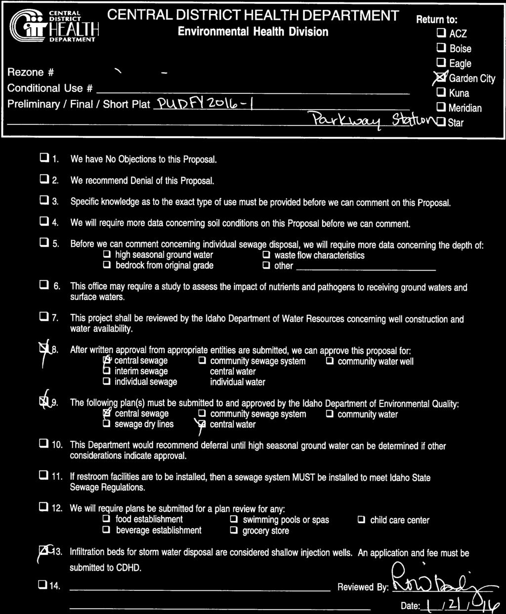
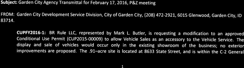
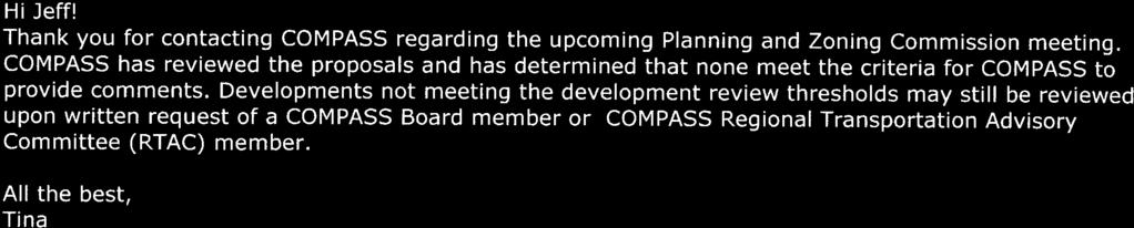
8 P a g e 8 possible via the density (and future commercial), adds to the vibrancy of the community relative to physical, social, and economic characteristics. Comments from Other Departments, Agencies and Committees The Design Review Committee has reviewed the landscape plan and dwelling unit design; the applicant will need final Design Review and tree mitigation approval prior to the submittal of a final plat. The City s Environmental Division has no concerns with the project overview. Construction drawings will be reviewed for compliance and construction methods will be monitored. Garden City Engineer The applicant will be required to comply with all requirements of the Garden City Engineer, prior to the submittal of a final plat. Water and wastewater services for the subdivision are required to be connected to the public systems available in the area; drainage will need to be accommodated on site. The Wastewater Manager has no concerns on the project, pursuant to an dated January 20, Other Agencies Ada County Highway District ACHD has provided preliminary comments, indicating that the applicant should be required to close the existing access to Adams Street and replace with vertical curb, cutter and sidewalk (a minimum of 7-foot wide attached or 5-foot wide detached). The applicant is proposing to construct the improvements to match those on the opposite side of 42 nd Street, which meets and exceeds ACHD policy. The site is expected preliminarily to generate an additional 272 vehicle trips per day, although this estimate may change since future uses on Lot 50 are not wholly apparent. Adams Street and Veterans Memorial Parkway will remain at better than Level of Service (LOS) "D". Central District Health Department The Central District Health Department has provided a letter dated January 21, 2016, stating central sewer and water are required. COMPASS The Community Planning Association of Southwest Idaho has provided an dated January 20, 2016, stating the proposals do not meet the criteria for COMPASS to provide comments. Idaho Transportation Department The Idaho Transportation Department has provided a letter dated January 22, 2016, stating no objection to the proposal. North Ada Fire and Rescue The North Ada County Fire and Rescue has provided a letter dated February 9, 2016, stating the subdivision can be approved subject to compliance with code requirements and conditions of approval. Pioneer Irrigation District The Pioneer Irrigation District has provided an dated January 23, 2016, stating the project falls outside of the district s boundaries and their facilities are not impacted. Comments from Public No comments from the public have been received to date. Recommended Conditions of Approval SUBFY2016-1: Parkway Station Subdivision
9 P a g e 9 1. The applicant shall comply with all requirements of the City Engineer. 2. The applicant shall comply with all requirements of the Ada County Highway District, including but not limited to approval of plans and construction or replacement of curb, gutter, and sidewalk on 42 nd Street and Adams Street. The streetscape shall be in substantial compliance with the plans date stamped by the City on January 12, Approval of water and wastewater systems for the subdivision is required prior to the submittal of the final plat. The applicant shall work with the City Public Works Department and the City Engineer to ensure that connections to public services are designed and constructed to meet Public Works standards and City ordinances. Plans and specifications shall be submitted for review and approval prior to the submittal of a final plat. 4. Each and every lot within the subdivision shall have underground pressurized irrigation water pursuant to GCC 8-5A-5 H. The pressurized irrigation system shall be constructed and installed at the same time as the domestic water lines, but shall not necessarily be in the same trenches. 5. All internal sidewalks, common driveways with curbing, hardscaping, and stormwater facilities shall be constructed in substantial compliance with the plans date stamped by the City on January 12, 2016, or as otherwise conditioned herein. 6. Lot 50, Block 1 is recognized as a future phase of development. The development of the Lot will be required to comply with all applicable ordinances and application processes in addition to the current application. 7. Add a note to Article 4.4 in the CC&Rs describing that the landscaping shall remain in substantial compliance with the plans and construction as approved by the Garden City Design Review Committee. The approved landscape plan should be attached as exhibits to the CC&Rs. The applicant shall provide a copy of the CC&Rs prior to the City Clerk signing the final plat. 8. Add a note to Article 3.11 in the CC&Rs describing that the drainage is not to be modified from the plans and construction in compliance with the plans date approved by Garden City. Any changes proposed to the drainage system shall be approved by the City Engineer. The approved drainage plan should be attached as exhibits to the CC&Rs. The applicant shall provide a copy of the CC&Rs prior to the City Clerk signing the final plat. 9. Add a Note to the Final Plat stating that no other vehicle access to the public streets, other than designated on the plat, is permitted. Clarify in the CC&Rs stating that Lot 1, Block 1, includes the provision for access to the public street. 10. Delineate a cross access easement on the plat along the western property line to allow bike/pedestrian and/or vehicle traffic connectivity in the future when the property(ies) to the west redevelops. Place a note in the CC&Rs identifying the intent of the easement and that a road or pathway may be established in the future when the property(ies) to the west redevelops. 11. Pursuant to GCC 8-5A-5 D, Lot 1, Block 1 may provide access to more than four-dwelling units. 12. Relative to GCC 8-5A-5 B5, all Lots within the subdivision are permitted relief from direct access to a public street since vehicle access is provided to via Lot 1, Block Provide a recorded copy of a Maintenance and Operations Manual detailing how the common driveways and private roads are to be maintained in good condition in perpetuity. The Maintenance and Operations Manual shall be provided prior to the City Engineer signing the final plat. 14. Provide a note on the final plat to read, "Minimum building setback lines shall be in accordance with the following": Front: 10-feet maximum* Rear: 0-feet (facing driveways) Side: 0-feet to 3-feet between units Street Side: 0-feet facing private street or common area SUBFY2016-1: Parkway Station Subdivision
10 SUBFY2016-1: Parkway Station Subdivision P a g e 10 *For Lots 21-24, facing the community garden (Lot 25), a 13-foot front setback is permitted. 15. The dwelling units to be built within the subdivision shall be in substantial with the architectural schematics as approved by the Design Review Committee. To assure compliance with this condition, the City reserves the right to deny, at its discretion, any building permit application that does not meet these architectural schematics. The City also reserves the right to deny a Certificate of Occupancy if the units are not built according to approved plans. 16. Clarify Article 4.2 of the CC&Rs to state that the dwellings shall be in substantial compliance with the architectural schematics as shown as approved by the Garden City Design Review Committee. The architectural schematics should be attached as exhibits to the CC&Rs. 17. Regarding on-site tree mitigation, the applicant shall submit details on the amount of tree caliper to be removed and verify that the new landscaping will meet the requirements of the Tree Preservation Provisions of Garden City Code (GCC 8-4I-7). Part of this mitigation may be accomplished through planting trees in the front yards of each dwelling. 18. Pedestrian scale yard lights are encouraged to be installed in the front yard setback of each dwelling. 19. Comply with all requirements of the North Ada County Fire and Rescue District pursuant to the letter of February 9, Comply with all requirements of the Central District Health Department pursuant to the letter dated January 21, The applicant shall submit payment to the City for all outstanding fees incurred by the City in obtaining a review of this project prior to the City issuing any permits or signing the final plat. 22. Any changes to the plans and specifications upon which this approval is based, other than those required by the above conditions, will require submittal of an application for modification and approval of that application prior to commencing any change. 23. RECOMMENDATION: As of the date of this writing, the Federal Emergency Management Agency has issued Draft Digital Federal Insurance Rate Maps (DFIRM) which proposes to delineate the subject properties to be within the 100-year Floodplain. The applicant should consider that any new structures must have the top of the lowest floor at or above BFE (as defined by adopted FIRM) pursuant to current Garden City Code. Stricter standards may be required in the future for building permit approval. General Requirements 1. Final approval is subject to the approval of other reviewing agencies. Any more restrictive standards adopted and made applicable by any Transportation Authority, Fire Authority or other Federal, State or Local regulatory agencies shall prevail. This approval shall not annul any portion of Garden City Code or other applicable regulation unless specifically noted. 2. All improvements and operations shall comply with applicable local, state and federal requirements and procedures whether specifically addressed in the analysis of this application or not. This shall include but not be limited to 8-4A General Provisions of Design and Development Regulations; 8-4I-3 and Landscape maintenance provisions 8-4I-9; and standards for transportation and connectivity provisions identified in 8-4E. 3. All utilities on the site, including telephone, cable television, and electrical systems shall be underground and in compliance with Garden City Code 8-4A Driveway openings in curbs shall comply with the requirements of the Transportation Authority. The driveway shall be straight or provide a 28-foot inside and 48-foot outside turning radius. 5. Plant materials which exhibit evidence of insect pests, disease, and/or damage shall be appropriately treated to correct the problem. Dead plant materials shall be replaced. 6. Where landscaping might impact motorist or pedestrian sight distance, shrubs shall be maintained below three feet (3') in height and trees shall be pruned so that the lowest branches will be at least seven feet (7') above the ground level.
11 SUBFY2016-1: Parkway Station Subdivision P a g e A three foot (3') clearance zone shall be maintained around the circumference of fire hydrants. 8. Retain and protect existing trees, vegetation, and native soils and integrate these features into the overall landscape plan. 9. Required landscape areas shall be at least seventy percent (70%) covered with vegetation at maturity, with mulch used under and around the plants. Use of mulch, organic or rock, as the only ground cover in required planting areas is prohibited. 10. If trees are staked, the stakes shall be removed within twelve (12) months to prevent damage to the tree. 11. All planting areas that border driveways, parking lots, and other vehicle use areas shall be protected by curbing, wheel stops, or other approved protective devices. 12. Trees shall be planted at least three feet (3') from curbs, sidewalks, driveways and other hard surfaces to buffer from stress caused by vehicle overhang and compacted soils, or planted with sufficient space to provide for the full maturity of the particular tree species. 13. All other plant material, except sod or ground cover, shall be set back a minimum of one foot (1') from any curb edge to protect from vehicle overhang and mechanical damage. 14. The landscape installation shall stabilize all soil and slopes. 15. All required landscaping shall be provided with an automatically controlled irrigation system in conformance with the best management practices for automatic irrigation systems. 16. Demonstrate compliance with 8-4G-1 prior to certificate of occupancies. 17. The approval is specific to the application provided and reviewed. 18. This approval is for this application only. Additional permits, licenses and approvals may be necessary. All other applicable permits must be obtained prior to a Certificate of Occupancy. 19. Property maintenance standards shall be maintained as required by Garden City Code 8-4K. 20. The property owner is responsible for the maintenance of all landscaping and screening devices required. 21. System Installation Required: Each and every lot within the subdivision shall have underground pressurized irrigation water. The pressurized irrigation system shall be constructed and installed at the same time as the domestic water lines, but shall not necessarily be in the same trenches. 22. Cross-Connections: All cross-connections between the domestic water lines and the irrigation water lines shall be in accord with the City s adopted standards, specifications and ordinances. 23. Utility easements that are unobstructed by permanent structures shall be provided along front lot lines, rear lot lines, and side lot lines when deemed necessary by the City Engineer. Total easement width shall not be less than ten feet (10'), with twelve feet (12') recommended, front and rear, with at least twenty feet (20') required for water and sewer easements for main lines. 24. Unobstructed easements, including but not limited to, drainage, water, and sewer easements shall be provided when deemed necessary by the City Engineer. 25. Materials submitted after the decision shall not be considered part of the record for this decision. If additional materials or information is submitted after the decision the application may be remanded to the decision making body during which time the decision shall be stayed provided that there is no immediate threat to life or safety. 26. Any changes in the design, construction, operation or use shall be brought to the immediate attention of the Planning Official for determination if the changes are in substantial conformance with the City s action. Any modification to approved plans shall require submittal and approval of these modifications prior to construction. Final approval is based on substantial conformance with the plans reviewed and approved. 27. Any substantial changes to the design shall be reviewed by the Design Review Committee for compliance with Garden City Code 8-4. Any other changes that are not in substantial conformance with the approval shall be remanded to the decision-making body. 28. No subdivision plat required shall be recorded by the Ada County Recorder until such subdivision plat has received final approval by the Council. No public board, agency, Commission, official or other authority shall proceed with the construction of or authorize the construction of any of the public improvements required by this Title until final plat has received the approval by the Council.
12 P a g e In the event that an applicant and/or owner cannot complete the non-life, safety and health improvements, within the time specified in the final subdivision approval or prior to occupancy, the City may require a surety agreement in accordance Garden City Code. Unless financial guarantees of improvement completion has been accomplished, no approval of the final subdivision or recording thereof shall be permitted unless the applicant provides satisfactory proof that all required public improvements and facilities have been fully and satisfactorily constructed and installed. Approval of a preliminary subdivision shall become null and void if the applicant fails to record a final subdivision within one (1) year of the approval of the preliminary subdivision. Development shall commence within two (2) years of approval. If the timetable is not met and the applicant does not receive a time extension, the application will expire and become null and void. 30. The Planning Official may authorize a single extension of time to record the final subdivision not to exceed one (1) year. Additional time extensions up to one (1) year as determined and approved by the City Council may be granted. With all extensions, the Planning Official or City Council may require the preliminary subdivision or combined preliminary and final subdivision to comply with the current regulations. 31. There is a 10 day right to appeal to City Council. An appeal shall be made on the form provided by the City and filed with the City Clerk within ten (10) days after the action of the decision. 32. Final decisions are subject to judicial review pursuant to The Idaho Administrative Procedures Act, Chapter 65 Title 67 Idaho Code. A takings analysis pursuant to Idaho Code may be requested on final decisions. 33. Occupying the site (dwelling units) prior to Certificate of Occupancy is a criminal offense. 34. This application shall be considered a commencement of this use; all previous uses at this location shall be considered abandoned. SUBFY2016-1: Parkway Station Subdivision
13
14 PLANNING SUBMITTAL FORM Permit info: Application Date: FOR OFFICE USE ONLY 6015 Glenwood Street Garden City, ID (tel.) (FAX) Rec d by: APPLICANT Name: Company: Address: City: PROPERTY OWNER Name: Company: Address: City: State: Zip: State: Zip: Tel.: FAX: Tel.: FAX: ACTION REQUESTED (check all that apply) ALL BLUEPRINTS MUST BE FOLDED INTO 8 1/2 X 11 SIZE WITH THE TITLE BLOCK/PANEL FACE UP SO AS TO FIT WITHIN A LEGAL SIZE FILE FOLDER Appeal Design Review Preliminary Plat Lot Line Adjustment Final Plat Preliminary PUD City Code Text Amendment Flood Plain Dev Re-zone Sign Permit Variance Zoning Certificate Specific Area Plan MFH Installation MFH Removal Comprehensive Plan Amendment Minor PUD Conditional (special) Use Permit Minor Land Division Temporary Use Permit Ability to Serve-CUP, DSR or SUB if applicable PROPERTY INFORMATION Site address: Subdivision Name: Lot: Block: Tax Parcel Number: Zoning: Total Acres: Proposed Use: Floodplain: yes no I consent to this application and hereby certify that information contained on this application and in the accompanying materials is correct to the best of my knowledge. I will hold harmless and indemnify the City of Garden City from any and all claims and/or causes of action from or an outcome of the issuance of a permit from the City. signature of the applicant (date) signature of the owner (date) Page 1 of 1 May 31, 2012

15 ANNEXATION/REZONE Permit info: Application Date: Rec d by: FOR OFFICE USE ONLY 6015 Glenwood Street Garden City, ID (tel.) (FAX) APPLICANT Name: PROPERTY OWNER Name: PROPERTY INFORMATION Site address: Existing Zoning: Existing use: Surrounding Zoning: Proposed Zoning: Proposed use: Surrounding Uses: Is the property proposed to be annexed into Garden City? YES NO How does the proposed zoning map amendment comply with the applicable provisions of the Comprehensive Plan? How does the proposed zoning map amendment comply with the regulations outlined for the proposed zoning district? How does the proposed zoning map amendment affect the public health, safety, and welfare of the community? Does a zoning map amendment result in an impact upon the delivery of services including, but not limited to, school districts, utilities, fire safety, school districts, etc? YES NO Page 1 of 7 October 31, 2008
16 If the property is proposed to be annexed, how is such an annexation in the best interest of the City? If the property is proposed to be annexed, is the property contiguous to property with Garden City jurisdiction? YES NO ALL BLUEPRINTS MUST BE FOLDED INTO 8 1/2 X 11 SIZE WITH THE TITLE BLOCK/PANEL FACE UP SO AS TO FIT WITHIN A LEGAL SIZE FILE FOLDER. APPLICATION INFORMATION REQUIRED NOTE: INCOMPLETE APPLICATIONS WILL NOT BE ACCEPTED UNDER ANY CIRCUMSTANCES. Planning Submittal Form Preliminary Title Report Fifteen (15) Site Plan Compliance Statement Statement of Intent Fifteen (15) Neighborhood Map Fifteen (15) Topographic Survey Fifteen (15) Master Plan Two (2) Natural Hazard and Resources Analysis Two (2) Dedications and Easements Affidavit of Legal Interest Neighborhood Meeting Verification Affidavit of Posting and Photos (required 7 days prior to the hearing Ability to Serve Letter INFORMATION REQUIRED ON COMPLIANCE STATEMENT (PLEASE CHECK): Statement explaining how the proposed structure(s) is compliant with the standards of review for the proposed application INFORMATION FOR STATEMENT OF INTENT(PLEASE CHECK): Should include purpose, scope, and intent of project Information concerning noxious uses, noise, vibration, and any other aspects of the use or structure that may impact adjacent properties or the surrounding community Page 2 of 7 October 31, 2008
17
18

19 January 8, 2016 Garden City 6015 Glenwood Street Garden City, ID Re: Compliance Statement Statement of Intent The goal of the Parkway Station development is to create a mix of diverse residences and commercial uses that compliment and build on the success of the recently completed Trailwinds Apartments. Currently the property consists of four parcels: 1. A single story commercial building fronting on Adams Street, 2. A repair shop and vehicle storage facility, 3. A vacant lot, 4. An aging mobile home park. The entire property is 4.07 acres and is currently zoned C-2 and M. The property is bounded by Adams Street, East 42 nd Street, Riverside Park and residential to the west. The northern portion of the site would be developed as residential with 32 lots for 3 story townhomes. 16 of the townhomes are arranged in two groups of eight and face E. 42 nd Street. The townhomes would have a similar height and set back as Trailwinds. The adjacent sidewalk would be reconstructed to ten feet wide with bulb outs, street trees and historic light fixtures to mirror the improvements on the opposite side of the street. Together the two projects will create a pedestrian friendly street scape with a unique sense of place. The result will be the essence of a vibrant corridor between Adams Street and the greenbelt that can be completed by the development of the lots to the north and south of Trailwinds. The townhouses will have distinctive features that will distinguish them as individual homes. The townhouses will have gable roofs, terraces, balconies, and entries that face the street. The buildings will be offset and vary in finish materials and color from a complimentary palette. 270 N. 27 th St. Suite A Boise, Idaho Telephone: Facsimile: hsaarchitects.com The northwest portion of the site adjacent to the park will be developed as nine cottages clustered around a common garden area. The one and one half story cottages will each have a room size covered front porch and main entry that faces the common area to encourage interaction and a sense of community. There is another cluster of 16 townhouses in the center of the site that are arranged in four groups of four. The rear garages share a common access lane. The fronts of these townhouses face onto a private street that loops through the residential section. The portion of the site at the corner of Adams and E. 42 nd is reserved for future commercial, and/or multifamily development. One vision is for commercial development on the corner with retail or restaurant on the ground floor and offices on the second floor and condos or multifamily on the southwest portion with parking at grade level under the residential units. An important feature of the development is a pedestrian path that connects the commercial area at Adams Street to Riverside Park. The path passes between the central group of townhomes and along one side of the common garden at the cottages and connects to the existing pathway in the park. As part of the PUD application process we will have reduced rear yard setbacks for the residential units.
20 The intent is to develop the residential portion first and leave options open for the commercial portion. The property will be fenced along the west property line with a 6 high solid fence. We are proposing a four foot wide planter between the private street and the fence for landscaping with enlarged planter strategically placed for tree planting. Between the development and Riverside Park a four foot high decorative metal fence is planned. There will be an opening in the fence where the pedestrian path connects with the park path. We are requesting a rezone of the entire property to M-Mixed Use to allow for the current proposed residential development and the future commercial and/or multifamily uses. We are also requesting approval of the preliminary plat of the new residential and common lots and the single commercial lot. Finally we are requesting approval of the proposed planned unit development as depicted on the accompanying drawings and documents. We believe the proposed project is the type of development that the Garden City comprehensive plan and zoning ordinance intended to inspire. We believe this project will be an asset to the community and will spark further positive redevelopment.
21
22
23
24
25
26
27
28


29

30


31

32 January 22, 2016 Mr. Jeff Lowe Garden City Development Service Division City of Garden City 6015 Glenwood Street Garden City, Idaho VIA RE: SUBFY PARKWAY STATION SUBDIVISION The Idaho Transportation Department (ITD) has reviewed the referenced rezone, preliminary plat, and planned unit development application for the Parkway Station Subdivision located on the northwest corner of Adams St. and E. 42 nd St. north of US-20/26. ITD has the following comments: 1. ITD has no objection to the proposed project and requires no mitigation. 2. This property does not abut the State highway system. If you have any questions, you may contact me directly at Sincerely, James K. Morrison Development Services Manager

33 Michael G. Irvan Commissioner/ Administrative Chief Shelley Young Administrative Manager Margaret Dimmick Commissioner Jeff Ramey Commissioner Fire & Rescue District February 9, 2016 Jeff Lowe Garden City Planning Re: Preliminary Plat and Rezone SUBFY2016-1, PUDFY2016-1, ZONFY Parkway Station 4232 Adams Street and 418 & nd Street, Garden City Dear Jeff, This is a request for a 50 lot mixed use development with 41 buildable lots for residential, eight common lots, and one mixed use lot. North Ada County Fire and Rescue has reviewed and can approve the application subject to compliance with all of the following code requirements and conditions of approval. Any deviation from this plan is subject to Fire Department approval. Please note that unless stated otherwise, this memo represents the requirements of the International Fire Code (IFC) as adopted and amended by NACFR Rules. Comments: 1. For streets having a width less than 29 feet, back of curb to back of curb parking shall be restricted on both sides. Parking shall be restricted on all sides of turn-arounds and cul-de-sacs. A note on the face of the final plat is required noting the parking restriction. In addition, No Parking signs shall be installed in accordance with the requirements of the IFC. 2. Fire hydrants capable of producing the required fire flows shall be located so that no part of a structure is more than 600-feet from a hydrant. (IFC 507.3, IFC B105.2) The number of hydrants on the plan are sufficient, but could be placed more appropriately for fire department use. The two hydrants located at the dead end lanes would be better placed at the intersections with Private Street B. 3. Fire Department required fire hydrants, access, and street identification shall be installed prior to construction or storage of combustible materials on site. Provisions may be made for temporary access and identification measures Glenwood Garden City, Idaho (208)
34 4. Fire department access roads in excess of 150 feet shall have a fire department turn around. Two of the dead end streets are greater than 150 feet. IFC General Requirement: Specific building construction requirements of the International Building Code, International Fire Code and Boise City Code will apply. However, these provisions are best addressed by a licensed Architect at time of building permit application. Fire Department required fire hydrants, access, and street identification shall be installed prior to construction or storage of combustible materials on site. Provisions may be made for temporary access and identification measures. Regards, Ron Johnson Division Chief Assistant Fire Marshal Boise Fire Department 5800 Glenwood Garden City, Idaho (208)

35
ARTICLE 17 SITE PLAN REVIEW
 ARTICLE 17 SITE PLAN REVIEW 17.01 INTENT AND PURPOSE The intent of this section is to provide for consultation and cooperation between the applicant and the township planning commission so that the applicant
CITY OF GARDEN CITY. Garden City Design Review Committee Staff Contact: Chris Samples STAFF REPORT: DSRFY Page 1
 Page 1 CITY OF GARDEN CITY 6015 Glenwood Street Garden City, Idaho 83714 Phone (208)472-2921 Fax (208)472-2926 File Number: DSRFY2018-9 For: Dutch Bros Stand Replacement Location: 5177 W. Chinden Blvd.,
ARTICLE 6: Special and Planned Development Districts
 ARTICLE 6: Special and Planned Development Districts 6-10 Traditional Neighborhood Development (TND) District 6-10.10 Purpose and Intent The Traditional Neighborhood Development (TND) District provides
Design Review Application *Please call prior to submittal meeting to determine applicable fees*
 CITY OF EAGLE 660 E. Civic Lane, Eagle, ID 83616 Phone#: (208) 939-0227 Fax: (208) 938-3854 Design Review Application *Please call prior to submittal meeting to determine applicable fees* FILE NO.: CROSS
PLANNED DEVELOPMENT (MASTER PLAN & UNIT PLAN)
") Central Permit Center 555 Santa Clara Street Vallejo CA 94590 Business License Building Fire Prevention Planning Public Works 707.648.4310 707.648.4374 707.648.4565 707.648.4326 707.651.7151 PLANNED DEVELOPMENT
Central Permit Center 555 Santa Clara Street Vallejo CA 94590 Business License Building Fire Prevention Planning Public Works 707.648.4310 707.648.4374 707.648.4565 707.648.4326 707.651.7151 PLANNED DEVELOPMENT
PLANNED UNIT DEVELOPMENT & SUBDIVISION STAFF REPORT Date: May 18, 2017
 & PUD-0000102-2017 PLANNED UNIT DEVELOPMENT & SUBDIVISION STAFF REPORT Date: May 18, 2017 NAME SUBDIVISION NAME Dauphin Creek Estates Subdivision Dauphin Creek Estates Subdivision LOCATION CITY COUNCIL
CITY OF ZEELAND PLANNING COMMISSION
 APPLICATION FOR SITE PLAN REVIEW AND SPECIAL LAND USE Date City Official App. Filing Fee Rec'd ($350) NOTE TO APPLICANT: Please submit this application for Site Plan Review along with twenty (20) copies
CITY OF GARDEN CITY. Garden City Design Review Committee Staff Contact: Chris Samples STAFF REPORT: DSRFY Page 1
 Page 1 CITY OF GARDEN CITY 6015 Glenwood Street Garden City, Idaho 83714 Phone (208)472-2921 Fax (208)472-2926 File Number: DSRFY2018-12 For: Brilliant Services - New Commercial Structure Location: 211
Project phasing plan (if applicable) 12 copies of site plan
 12 copies of site plan") SITE PLAN REVIEW PERMIT APPLICATION City of Grand Haven, 11 N. Sixth Street, Grand Haven, MI 49417 Phone: (616) 847-3490 Fax: (616) 844-2051 Website: www.grandhaven.org 1. Project Information Address/location
SITE PLAN REVIEW PERMIT APPLICATION City of Grand Haven, 11 N. Sixth Street, Grand Haven, MI 49417 Phone: (616) 847-3490 Fax: (616) 844-2051 Website: www.grandhaven.org 1. Project Information Address/location
Asbury Chapel Subdivision Sketch Plan
 Asbury Chapel Subdivision Sketch Plan PART 1: PROJECT SUMMARY Applicant: NVR Inc. Project Size: +/- 76.13 acres Parcel Numbers: 02101112,02116101,02116112, 02116113 Current Zoning: Transitional Residential
ARTICLE V PLANNED UNIT DEVELOPMENT DISTRICT
 ARTICLE V PLANNED UNIT DEVELOPMENT DISTRICT A. Purpose and Objective The Planned Unit Development (PUD) procedure provides a flexible land use and design regulation through the use of performance criteria
Application for Site Plan Review
 Application for Site Plan Review City of Pontiac Office of Land Use and Strategic Planning 47450 Woodward Ave, Pontiac, MI 48342 T: 248.758.2800 F: 248.758.2827 Property/Project Address: Sidwell Number:
EXHIBIT B PROJECT NARRATIVE POULSBO MEADOWS
 EXHIBIT B PROJECT NARRATIVE POULSBO MEADOWS Name of Project: Poulsbo Meadows; A Planned Residential Development (PRD)/Plat Applicants Name: PBH Group LLC/Byron Harris PO Box 1010 Silverdale, WA 98038 Description
At Your Disposal CUP Amendment, Lot 20, Village Service Commercial, at 128 Bastille Dr. (PLN17-208)
") MEMORANDUM Archuleta County Development Services Planning Department 1122 HWY 84 P. O. Box 1507 Pagosa Springs, Colorado 81147 970-264-1390 Fax 970-264-3338 TO: Archuleta County Planning Commission FROM:
MEMORANDUM Archuleta County Development Services Planning Department 1122 HWY 84 P. O. Box 1507 Pagosa Springs, Colorado 81147 970-264-1390 Fax 970-264-3338 TO: Archuleta County Planning Commission FROM:
CHESAPEAKE LANDSCAPE ORDINANCE
 CHESAPEAKE LANDSCAPE ORDINANCE CONSERVATION PRESERVATION CZO 19-600 Effective October 16, 2008 BUFFER YARD C PARKING LOT REFORESTATION YEAR 1 REFORESTATION YEAR 4 BUFFER YARD F CBPA REFORESTATION Page
VILLAGE OF CLEMMONS PLANNING BOARD DRAFT STAFF REPORT. Single Family Residential, Townhomes
 VILLAGE OF CLEMMONS PLANNING BOARD DRAFT STAFF REPORT PETITION INFORMATION Docket # C-212 Staff Megan Ledbetter Petitioner(s) Peacehaven Development LLC Owner(s) Larry Jarvis, William Alexander and Peacehaven
Subdivision Staff Report
 Subdivision Staff Report Name: Bridgewalk Subdivision Date: December 8, 2004 File: SUB04-00089 Meeting: December 14, 2004 Approval: Preliminary To: City Council Lead Agency: Boise City From: Richard Beck
PLANNED UNIT DEVELOPMENT Date: May 4, 2017
 PLANNED UNIT DEVELOPMENT Date: May 4, 2017 DEVELOPMENT NAME LOCATION Sarah & Michael Stashak 2165 & 2167 Old Shell Road (South side of Old Shell Road, at the Southern terminus of Frazier Court) CITY COUNCIL
Neo-Traditional Overlay Application
 MAYOR AND CITY COUNCIL OF LAUREL DEPARTMENT OF ECONOMIC AND COMMUNITY DEVELOPMENT 8103 Sandy Spring Road Laurel, Maryland 20707 (301) 725-5300 Internet Address http://www.cityoflaurel.org E-mail: ecd@laurel.md.us
SUBMITTAL REQUIREMENTS: FINAL PLAN REVIEW- PROJECT DEVELOPMENT PLAN (PDP)
") 1) Application form and filing fee. Application Form.pdf Development Review Guide STEP 6 of 8 SUBMITTAL REQUIREMENTS: FINAL PLAN REVIEW- PROJECT DEVELOPMENT PLAN (PDP) 2) Transportation Development Review
1) Application form and filing fee. Application Form.pdf Development Review Guide STEP 6 of 8 SUBMITTAL REQUIREMENTS: FINAL PLAN REVIEW- PROJECT DEVELOPMENT PLAN (PDP) 2) Transportation Development Review
Applicant Name Phone / Fax / Address City State Zip Code . Property Owner Phone / Fax / Address City State Zip Code
 Master Development Plan Application Community Development Department City of Redmond 411 SW 9 th Street Redmond, Oregon 97756 541-923-7721 541-548-0706 FAX Master Development Plan Fee $38,862.52 File Number
Request Alternative Compliance to the prescribed criteria of the Oceanfront Resort District Form-Based Code. Staff Planner Kristine Gay
 Applicant/Owner Ocean Rental Properties, LLC Public Hearing April 13, 2016 City Council Election District Beach Agenda Item 1 Request Alternative Compliance to the prescribed criteria of the Oceanfront
TOWNSHIP OF LOGAN SOIL & FILL IMPORTATION AND PLACEMENT APPLICATION SUBMITTAL CHECKLIST
 TOWNSHIP OF LOGAN SOIL & FILL IMPORTATION AND PLACEMENT APPLICATION SUBMITTAL CHECKLIST Applications: 5 copies of application - Applicant will reproduce the copies at his/her costs. The Township Clerk
5.1.1 The streetscape along US Highway 64 (Brevard Road); and, The built environment within new residential developments; and,
; and, The built environment within new residential developments; and,") Article 5. Landscaping 5.1 Purpose The Town of Laurel Park s landscape standards are designed to create a beautiful, aesthetically pleasing built environment that will complement and enhance community
Article 5. Landscaping 5.1 Purpose The Town of Laurel Park s landscape standards are designed to create a beautiful, aesthetically pleasing built environment that will complement and enhance community
SPECIFIC PLAN Requirements
 CITY OF LANCASTER PLANNING DEPARTMENT 44933 Fern Avenue, Lancaster, California 93534 (661) 723-6100 SPECIFIC PLAN Requirements Purpose The purpose of a specific plan is to provide for the logical development
AWH REPORT OF THE PLANNING AND DEVELOPMENT DEPARTMENT FOR APPLICATION FOR REZONING ORDINANCE TO PLANNED UNIT DEVELOPMENT
 AWH REPORT OF THE PLANNING AND DEVELOPMENT DEPARTMENT FOR APPLICATION FOR REZONING ORDINANCE TO PLANNED UNIT DEVELOPMENT MAY 8, 2014 The Planning and Development Department hereby forwards to the Planning
City of Reedley Community Development Department 1733 Ninth Street Reedley, CA (559) FAX
 FAX") City of Reedley SPECIAL PERMIT Submittal Requirements Conditional Use Permit (CUP), Site Plan Review (SPR) & Variance (VAR) Please use this information sheet as a checklist to assemble materials required
City of Reedley SPECIAL PERMIT Submittal Requirements Conditional Use Permit (CUP), Site Plan Review (SPR) & Variance (VAR) Please use this information sheet as a checklist to assemble materials required
CONSENT CALENDAR CITY PLANNING COMMISSION AGENDA ITEM NO: A.1, A.2 STAFF: LARRY LARSEN
 Page 8 CONSENT CALENDAR CITY PLANNING COMMISSION AGENDA ITEM NO: A.1, A.2 STAFF: LARRY LARSEN FILE NO: CPC PUZ 14-00013 - QUASI-JUDICIAL FILE NO: CPC PUD 14-00014 QUASI-JUDICIAL PROJECT: APPLICANT: OWNER:
Landscape and fencing requirements of this Chapter shall apply to all new landscaped areas.
 Chapter 19.06. Landscaping and Fencing. Sections: 19.06.01. Purpose. 19.06.02. Required Landscaping Improvements. 19.06.03. General Provisions. 19.06.04. Landscaping Plan. 19.06.05. Completion of Landscape
CITY PLANNING COMMISSION AGENDA ITEM: C STAFF: ROBERT TEGLER FILE NO: CPC PUD QUASI-JUDICIAL
 CPC AGENDA June 8, 2006 Page 37 CITY PLANNING COMMISSION AGENDA ITEM: C STAFF: ROBERT TEGLER FILE NO: CPC PUD 05-294 - QUASI-JUDICIAL PROJECT: APPLICANT: OWNER: PARKWOOD AT WOLF RANCH NASS DESIGN ASSOCIATES
FIRE PREVENTION OFFICE Placer Hills Fire Protection District NEW PROJECT GUIDELINES
 Established 1949 FIRE PREVENTION OFFICE Placer Hills Fire Protection District NEW PROJECT GUIDELINES The following are guidelines for new development. Any submitted plans must comply with these guidelines,
VALLEY COUNTY MINIMUM STANDARDS FOR PRIVATE ROAD DESIGN AND CONSTRUCTION
 MINIMUM STANDARDS FOR PRIVATE ROAD DESIGN AND CONSTRUCTION Adopted November 28, 2005 TABLE OF CONTENTS DEFINITION OF TERMS...II I. DESIGN CRITERIA... 1 A. GENERAL DESIGN CRITERIA... 1 B. ROADWAY CLASSIFICATION...
WHEREAS, after consideration of the evidence presented at the public hearing on January 14, 2010, the Prince George's County Planning Board finds:
 R E S O L U T I O N WHEREAS, the Prince George s County Planning Board has reviewed DDS-600 requesting a departure for the location of two loading spaces without driveway access along Toledo Terrace in
APPENDIX J PERFORMANCE STANDARDS FOR GRAVEL MINE, PIT MINE, OR QUARRY
 APPENDIX J PERFORMANCE STANDARDS FOR GRAVEL MINE, PIT MINE, OR QUARRY A. Purpose: 1. Regulatory Requirement and Use Mitigation: The purpose of this appendix is to provide a regulatory context (standards)
SITE PLAN REVIEW ITEMS - REFERENCE CHECKLIST
 City of Seminole 9199 113 th Street N. Seminole, FL 33772 Ph: (727) 392-1966 Fx: (727) 319-6583 SITE PLAN REVIEW ITEMS - REFERENCE CHECKLIST Note: This checklist is designed to aid designers in the review
PLANNED UNIT DEVELOPMENT Date: April 5, 2018
 PLANNED UNIT DEVELOPMENT Date: April 5, 2018 DEVELOPMENT NAME SUBDIVISION NAME LOCATION Robert Myers Robert Myers 2955 and 2989 Dauphin Street (Southeast corner of Dauphin Street and Sage Avenue) CITY
R E S O L U T I O N. Single-Family Residence/ Church. 2,488 sq. ft. 2,488 sq. ft. Area Parking Required: Church
 R E S O L U T I O N WHEREAS, the Prince George s County Planning Board is charged with the approval of Detailed Site Plans pursuant to Part 3, Division 9 of the Zoning Ordinance of the Prince George s
Glenborough at Easton Land Use Master Plan
 Implementation 114 9.0 IMPLEMENTATION 9.1 OVERVIEW This chapter summarizes the administrative procedures necessary to implement the proposed land use plan, infrastructure improvements, development standards,
Request Conditional Rezoning (R-15 Residential to Conditional A-24 Apartment) Staff Recommendation Approval. Staff Planner Jimmy McNamara
 Staff Recommendation Approval. Staff Planner Jimmy McNamara") Applicant Franklin Johnston Group Management & Development, LLC Property Owner Virginia Wesleyan College Public Hearing July 12, 2017 City Council Election District Bayside Agenda Item 3 Request Conditional
Applicant Franklin Johnston Group Management & Development, LLC Property Owner Virginia Wesleyan College Public Hearing July 12, 2017 City Council Election District Bayside Agenda Item 3 Request Conditional
PLANNING REPORT CITY OF EAGAN. APPLICANT: Cedar Grove Hospitality, LLC HEARING DATE: December 18, 2014
 PLANNING REPORT CITY OF EAGAN REPORT DATE: December 8, 2014 CASE: 19-PA-11-11-14 APPLICANT: Cedar Grove Hospitality, LLC HEARING DATE: PROPERTY OWNER: The Flats at Cedar APPLICATION DATE: Nov. 21, 2014
CUP Idaho Power Company
 CUP16-00059 Idaho Power Company Summary Conditional use permit for the addition of a solar power facility adjacent to an existing Idaho Power substation site located on 42.9 acres at 2001 E. Amity Road
SUBDIVISION, PLANNED UNIT DEVELOPMENT, PLANNING APPROVAL, REZONING & SIDEWALK WAIVER STAFF REPORT Date: February 7, 2013
 SUBDIVISION, PLANNED UNIT DEVELOPMENT, PLANNING APPROVAL, REZONING & SIDEWALK WAIVER STAFF REPORT Date: February 7, 2013 APPLICANT NAME SUBDIVISION NAME DEVELOPMENT NAME LOCATION S. E. Cemeteries of AL
PRELIMINARY CONDITIONAL USE SUBMITTAL CHECKLIST REQUIREMENTS
 This checklist must accompany your submittal as the cover page. CONDITIONAL USE Application Submittal Checklist for PRELIMINARY AND FINAL APPROVAL Per Winter Park Land Development Code Sec. 58-90 PRELIMINARY
Approved: CITY OF ARDEN HILLS, MINNESOTA PLANNING COMMISSION WEDNESDAY, AUGUST 5, :30 P.M. - ARDEN HILLS CITY HALL
 Approved: CITY OF ARDEN HILLS, MINNESOTA PLANNING COMMISSION WEDNESDAY, AUGUST 5, 2015 6:30 P.M. - ARDEN HILLS CITY HALL PLANNING CASES A. Planning Case 15-016; Final Planned Unit Development Arden Plaza;
TETON COUNTY FIRE PROTECTION RESOLUTION FOR NEW SUBDIVISIONS 2008 Edition. Chapter I General Provisions
 TETON COUNTY FIRE PROTECTION RESOLUTION FOR NEW SUBDIVISIONS 2008 Edition Chapter I General Provisions SECTION 1.1: TITLE. This Resolution shall be known as the Teton County Fire Protection Resolution
TOP TEN LIST OF COMMUNITY CONCERNS REGARDING PROPOSED AMENDMENTS TO CHAPTER 42
 TOP TEN LIST OF COMMUNITY CONCERNS REGARDING PROPOSED AMENDMENTS TO CHAPTER 42 1. Extend the urban area to Beltway 8 in stages, over say a three-year period, prioritizing development in transit and declining
ZONING ORDINANCE FOR THE ZONED UNINCORPORATED AREAS ARTICLE 1150 OF PUTNAM COUNTY, WEST VIRGINIA Page 95 ARTICLE 1150 SITE PLAN REVIEW
 OF PUTNAM COUNTY, WEST VIRGINIA Page 95 1150.01 PURPOSE 1150.02 APPLICABILITY 1150.03 APPLICATION PROCESS 1150.04 REVIEW PROCESS 1150.05 REVIEW CRITERIA 1150.06 SITE PLAN GUIDELINES 1150.01 PURPOSE ARTICLE
ORDINANCE WHEREAS, this Ordinance is consistent with the City of Winter Garden Comprehensive Plan; and
 ORDINANCE 17-06 AN ORDINANCE OF THE CITY COMMISSION OF THE CITY OF WINTER GARDEN, FLORIDA, CREATING ARTICLE XIV OF CHAPTER 118 OF THE CITY OF WINTER GARDEN CODE OF ORDINANCES PROVIDING FOR THE EAST PLANT
CITY OF KEIZER MASTER PLAN APPLICATION & INFORMATION SHEET
 CITY OF KEIZER MASTER PLAN APPLICATION & INFORMATION SHEET PRE-APPLICATION CONFERENCE Prior to the actual filing of a Master Plan application, it is strongly recommended that the applicant contact Planning
COUNTY COUNCIL OF PRINCE GEORGE'S COUNTY, MARYLAND SITTING AS THE DISTRICT COUNCIL 2010 Legislative Session. Council Members Dernoga and Olson
 DR- COUNTY COUNCIL OF PRINCE GEORGE'S COUNTY, MARYLAND SITTING AS THE DISTRICT COUNCIL 00 Legislative Session Bill No. CB--00 Chapter No. Proposed and Presented by Introduced by Co-Sponsors The Chairman
BYLAW C A Bylaw of Rocky View County to amend Land Use Bylaw C
 BYLAW C-7720-2017 A Bylaw of Rocky View County to amend Land Use Bylaw C-4841-97. The Council of Rocky View County enacts as follows: PART 1 TITLE This Bylaw shall be known as Bylaw C-7720-2017. PART 2
GENERAL LANDSCAPE PROVISIONS. The following landscape provisions shall be adhered to by all land uses unless otherwise noted:
 CHAPTER 1.18 Sections: 1.18.005 Purpose. 1.18.010 Landscaping, Buffering, and Fencing Improvements Required. 1.18.015 General Landscape Provisions. 1.18.020 Landscaping Plan. 1.18.025 Single-Family Dwellings
Request Conditional Use Permit (Car Wash Facility) Staff Recommendation Approval. Staff Planner Jonathan Sanders
 Staff Recommendation Approval. Staff Planner Jonathan Sanders") Applicant Property Owner SunTrust Bank Public Hearing October 10, 2018 City Council Election District Princess Anne Agenda Item 2 Request Conditional Use Permit (Car Wash Facility) Staff Recommendation
Applicant Property Owner SunTrust Bank Public Hearing October 10, 2018 City Council Election District Princess Anne Agenda Item 2 Request Conditional Use Permit (Car Wash Facility) Staff Recommendation
Site Plan Review Residential Accessory Building
 COMMUNITY DEVELOPMENT DEPARTMENT Planning Division P.O. Box 490 333 Broadalbin Street SW Albany, OR 97321 Phone (541) 917-7550 Fax (541) 917-7598 www.cityofalbany.net Site Plan Review Residential Accessory
PART 1: PROJECT SUMMARY. Proposed Land Use: 120 single-family lots. The application is Attachment A. The site plan is Attachment B.
 PART 1: PROJECT SUMMARY Applicant: JBH Development, LLC and Hopper Communities, INC Project Size: +/- 80.48 acres Parcel Number: 01513107, 01513108, 01513109, 01513113, 01513120, 01513121, 01513122, 01513124,
CITY PLANNING COMMISSION AGENDA. ITEM NO(s): C.1 C.3 STAFF: STEVE TUCK
: C.1 C.3 STAFF: STEVE TUCK") Page 34 CITY PLANNING COMMISSION AGENDA ITEM NO(s): C.1 C.3 STAFF: STEVE TUCK FILE NOS: CPC ZC 12-00035 QUASI-JUDICIAL CPC NV 12-00036 QUASI-JUDICIAL AR DP 12-00039 QUASI-JUDICIAL PROJECT: APPLICANT: OWNER:
Page 34 CITY PLANNING COMMISSION AGENDA ITEM NO(s): C.1 C.3 STAFF: STEVE TUCK FILE NOS: CPC ZC 12-00035 QUASI-JUDICIAL CPC NV 12-00036 QUASI-JUDICIAL AR DP 12-00039 QUASI-JUDICIAL PROJECT: APPLICANT: OWNER:
Major Subdivision Sketch Plan Checklist
 This checklist provides specific requirements that are apart of the Sketch process. The entire process is described by the Huntersville Subdivision Review Process which details all the submittal and resubmittal
SUBMITTAL REQUIREMENTS
 WHEN PROCESS TYPE III IS USED References to Process Type III applications are found in several places in the Milton Municipal Code (MMC), indicating that the development, activity, or use, is permitted
PLANNED UNIT DEVELOPMENT APPLICATION
 PLANNED UNIT DEVELOPMENT APPLICATION CITY OF THE DALLES Community Development Department 313 Court Street The Dalles, OR 97058 (541) 296-5481, ext. 1125 Fax (541) 298-5490 www.ci.the-dalles.or.us Date
The Town Board of the Town of Vienna, County of Dane, State of Wisconsin, does ordain and adopt as follows.
 ORDINANCE DRIVEWAYS AND CULVERTS NO. 6-5-06 ORDINANCE CONCERNING DRIVEWAY AND CULVERT REQUIREMENTS 1-1-1 Driveway Permits; Culvert Requirements 1-1-2 Driveway and Culvert Location, Design and Construction
Drexel, Barrell & Co.
 Drexel, Barrell & Co. June 18, 2018 Engineers/Surveyors Boulder Colorado Springs Greeley 3 South 7 th Street Colorado Springs, Colorado 80905-1501 719 260-0887 719 260-8352 Fax El Paso County Planning
VILLAGE OF CLEMMONS PLANNING BOARD DRAFT STAFF REPORT
 VILLAGE OF CLEMMONS PLANNING BOARD DRAFT STAFF REPORT PETITION INFORMATION Docket # C-226 Staff Megan Ledbetter Petitioner(s) JBJH Properties, LLC Owner(s) JBJH Properties, LLC Subject Property 5892-49-1766
SYRINGA VALLEY SPECIFIC PLAN NARRATIVE
 SYRINGA VALLEY SPECIFIC PLAN NARRATIVE Introduction With this application, Pleasant Valley South LLC ( Pleasant Valley ) seeks the City of Boise s approval of a new Specific Plan Ordinance to be added
APPLICATION FOR REZONING PROPERTY CITY OF HOLLAND, MICHIGAN. Name of Applicant. Address, and Phone # of Applicant
 APPLICATION FOR REZONING PROPERTY CITY OF HOLLAND, MICHIGAN Name of Applicant Address, Email and Phone # of Applicant Name and Address of Owner (if other than applicant) Ownership Interest of Applicant
ZONING AMENDMENT & PLANNED UNIT DEVELOPMENT STAFF REPORT Date: April 4, 2013
 ZONING AMENDMENT & PLANNED UNIT DEVELOPMENT STAFF REPORT Date: April 4, 2013 NAME DEVELOPMENT NAME LOCATION DIP Exchange, LLC DIP Exchange, LLC 93 Sidney Phillips Drive (West side of Sidney Phillips Drive,
CHAPTER SPECIAL PURPOSE AND OVERLAY ZONING DISTRICTS
 Special Purpose and Overlay Zoning Districts 106.28.010 CHAPTER 106.28 - SPECIAL PURPOSE AND OVERLAY ZONING DISTRICTS SPECIAL PURPOSE AND OVERLAY ZONING DISTRICTS Sections: 106.28.010 - Purpose 106.28.020
F. The following uses in the HR District: attached single-family dwellings, condominiums, and institutional uses; and
 1102 DESIGN REVIEW 1102.01 PURPOSE AND APPLICABILITY Section 1102 is adopted to provide standards, criteria, and procedures under which design review may be approved. Design review is required for: A.
CHAPTER 26 LANDSCAPING (Chapter added in its entirety 05-08)
") CHAPTER 26 LANDSCAPING (Chapter added in its entirety 05-08) 26.01 DESCRIPTION AND PURPOSE. Landscaping is an important element of the use, development and preservation of land, and a significant factor
CHAPTER 26 LANDSCAPING (Chapter added in its entirety 05-08) 26.01 DESCRIPTION AND PURPOSE. Landscaping is an important element of the use, development and preservation of land, and a significant factor
D1 September 11, 2013 Public Hearing APPLICANT:
 D1 September 11, 2013 Public Hearing APPLICANT: BEACH MUNICIPAL FEDERAL CREDIT UNION PROPERTY OWNER: SISTERS II, LLC STAFF PLANNER: Karen Prochilo REQUEST: Conditional Change of Zoning (AG-2 Agriculture
Bylaw A Bylaw to amend Bylaw 12800, as amended, The Edmonton Zoning Bylaw Amendment No. 2239
 Bylaw 17672 A Bylaw to amend Bylaw 12800, as amended, The Edmonton Zoning Bylaw Amendment No. 2239 WHEREAS City Council at its meeting of February 22, 2001, gave third reading to Bylaw 12800, as amended;
Ephrata Municipal Code, Chapter 19.07, Landscaping Regulations DRAFT January 28, 2013 Page 1
 Chapter 19.07 LANDSCAPING REGULATIONS Sections: 19.07.010 Purpose. 19.07.020 Landscape plan approval. 19.07.030 Failure to complete required landscaping Inspection. 19.07.040 General landscape requirements
The petition proposes the development of five townhomes on a vacant parcel between Charlotte Latin School and Providence Presbyterian Church.
 Rezoning Petition 2017-202 Final Staff Analysis June 18, 2018 REQUEST LOCATION Current Zoning: R-3 (single family residential) Proposed Zoning: UR-2(CD) (urban residential, conditional) with five-year
Request Change in Nonconformity. Staff Recommendation Approval. Staff Planner Jonathan Sanders
 Applicant & Owner Public Hearing April 11, 2018 City Council Election District Beach Agenda Item 5 Request Change in Nonconformity Staff Recommendation Approval Staff Planner Jonathan Sanders Location
PLANNING COMMISSION Work Session Meeting Agenda
 PLANNING COMMISSION Work Session Meeting Agenda 5200 85TH AVENUE NORTH BROOKLYN PARK MN 55443 PHONE (763) 424-8000 FAX (763) 493-8391 Wednesday, September 27, 2017-7:00 P.M. Brooklyn Township Room If due
C-I-10. The effect of establishing a comprehensive site review as follows will: B. Reduce the cluttered aspects of current development by:
 C-I-10 PART C SECTION I ARTICLE 10 GENERAL REGULATIONS PROJECT SITE REVIEW I. Purpose The effect of establishing a comprehensive site review as follows will: A. Protect streetscapes from projects that
DEPARTMENT OF PLANNING JEFFERSON PARISH, LOUISIANA
 DEPARTMENT OF PLANNING JEFFERSON PARISH, LOUISIANA DESIGN REVIEW REPORT : CPZ-3-1 : (S) Cynthia Lee-Sheng AT LARGE: A Chris Roberts B Elton M. Lagasse ADVERTISING DATES: 06/03/1 06/10/1 06/17/1 PAB PUBLIC
1173 W. University Dr. Request to construct a new Alumni Center.
 John S. Franden, President Mitchell A. Jaurena, Vice President Rebecca W. Arnold, Commissioner Sara M. Baker, Commissioner Jim D. Hansen, Commissioner Date: May 22, 2014 To: Jennifer Wheeler Boise State
Site Development Plan (SDP) Checklist
 Checklist") Development Services Department 100 N. Wilcox Street, Castle Rock CO 80104 303-660-1393 or CRGov.com Site Development Plan (SDP) Checklist A complete Site Development Plan (SDP) submittal will contain
Development Services Department 100 N. Wilcox Street, Castle Rock CO 80104 303-660-1393 or CRGov.com Site Development Plan (SDP) Checklist A complete Site Development Plan (SDP) submittal will contain
Chapter RM MULTI FAMILY BUILDING ZONES
 Chapter 19.17 RM MULTI FAMILY BUILDING ZONES 19.17.010 Established 19.17.020 Primary Permitted Uses 19.17.030 Accessory Permitted Uses 19.17.040 Secondary Permitted Uses 19.17.050 Conditional Property
Chapter PEDESTRIAN COMMERCIAL (PC) ZONING DISTRICT
 ZONING DISTRICT") Chapter 11-17 PEDESTRIAN COMMERCIAL (PC) ZONING DISTRICT Sections: 11-17-01 GENERAL PURPOSE 11-17-02 PERMITTED BUILDING TYPES 11-17-03 USES PERMITTED WITH DESIGN REVIEW 11-17-04 USES PERMITTED BY CONDITIONAL
Chapter 11-17 PEDESTRIAN COMMERCIAL (PC) ZONING DISTRICT Sections: 11-17-01 GENERAL PURPOSE 11-17-02 PERMITTED BUILDING TYPES 11-17-03 USES PERMITTED WITH DESIGN REVIEW 11-17-04 USES PERMITTED BY CONDITIONAL
Baumgarten MPUD. Exhibit 3 Evaluation Criteria
 Pursuant to LDC subsections 10.02.13 B, 10.02.08 F and Chapter 3 G. of the Administrative Code, staff s analysis and recommendation to the Planning Commission, and the Planning Commission s recommendation
PARKLET PROPOSAL PACKAGE & PROCESS
 500.3 I PARKLETS The term parklet refers to a small temporary constructed seating or community gathering area over an on-street parking space or an extension of the sidewalk into the operating State highway
Staff Report and Recommendation
 Community Planning and Development Planning Services 201 W. Colfax Ave., Dept. 205 Denver, CO 80202 p: 720.865.2915 f: 720.865.3052 www.denvergov.org/cpd TO: City Council Neighborhoods and Planning Committee
PLANNED UNIT DEVELOPMENT & SUBDIVISION STAFF REPORT Date: March 15, 2012
 PLANNED UNIT DEVELOPMENT & SUBDIVISION STAFF REPORT Date: March 15, 2012 DEVELOPMENT NAME SUBDIVISION NAME LOCATION OSR Subdivision OSR Subdivision 5559 Old Shell Road (South side of Old Shell Road, 570
O Dell Parkway PUD Association, Inc. PO Box 1335
 CITY OF SOUTH BURLINGTON DEVELOPMENT REVIEW BOARD SD_14_06_F+MDevelopment_25BaconSt_sketch SKETCH PLAN REVIEW #SD-14-06 O DELL PARKWAY PUD DEPARTMENT OF PLANNING & ZONING Report preparation date: April
LANDSCAPE AND IRRIGATION PLAN PREPARATION GUIDELINES
 LANDSCAPE AND IRRIGATION PLAN PREPARATION GUIDELINES The Parks Planning and Development Division of the City of Modesto s Parks, Recreation and Neighborhoods Department is responsible for the task of reviewing
 Villa Vizcaya PUD Amendment No. 3 4 April 16, 2008 May 29, 2015 Presented to: City of Port St. Lucie Planning and Zoning Department 121 SW Port St. Lucie Boulevard Port St. Lucie, Florida 34984 Exhibit
SITE PLAN REVIEW APPLICATION AND CHECKLIST
 SITE PLAN REVIEW APPLICATION AND CHECKLIST PROJECT SUMMARY: Project Name: City/ETA Location: City ETA (Application fee & number of copies needed are based on location) Property Location (Legal Description
LANDSCAPE ORDINANCE PASADENA PLANNING DEPARTMENT (713) FAX (713)
 FAX (713)") LANDSCAPE ORDINANCE PASADENA PLANNING DEPARTMENT (713) 475-5543 FAX (713) 477-1072 ARTICLE X. LANDSCAPING OF NONRESIDENTIAL SITES* Sec. 9-195. Applicability. (a) This article shall apply to the following:
LANDSCAPE ORDINANCE PASADENA PLANNING DEPARTMENT (713) 475-5543 FAX (713) 477-1072 ARTICLE X. LANDSCAPING OF NONRESIDENTIAL SITES* Sec. 9-195. Applicability. (a) This article shall apply to the following:
Construction and Landscaping on Public Property
 Construction and Landscaping on Public Property City of Manhattan Beach Community Development Department 1400 Highland Avenue 310-802-5504 www.citymb.info January, 2004 Construction and Landscaping on
Community Development Rezoning Report REZ14-006
 Community Development Rezoning Report REZ14-006 Planning Commission Board of Supervisors March 4, 2014 March 26, 2014 Applicant M & N Real Estate, LLC Tax Map Id 125-(A)- L20E,125-(A)- L20E1, portion of
City of Yelm. Tahoma Terra Final Master Plan Development Guidelines. Table of Contents
 City of Yelm Tahoma Terra Final Master Plan Development Guidelines Table of Contents Table of Contents... 1 Purpose... 2 Low Density Residential (R4-6)... 3 Moderate Density Residential (R6-10)... 5 Neighborhood
ARTICLE VI: SITE PLAN REVIEW
 Section 6.01 - Site Plan Review (All Districts) ARTICLE VI: SITE PLAN REVIEW Site plans give the Planning commission an opportunity to review development proposals in a concise and consistent manner. The
MIXED-USE VILLAGE OVERLAY FLOATING DISTRICT
 MIXED-USE VILLAGE OVERLAY FLOATING DISTRICT Zoning regulations developed by committee to the Planning Board for the Town of DeWitt, NY Issue date: 13 July 2017 revised 3/12/2018, revised 4/26/2018, 5/9/2018
Town of Excelsior, Sauk County, Wisconsin DRIVEWAY ORDINANCE
 Town of Excelsior, Sauk County, Wisconsin DRIVEWAY ORDINANCE 1.01 PURPOSE The purpose of this ordinance is to regulate the establishment, construction, improvement, modification or reworking of a driveway
Ten Mile Creek Planning Area
 PLANNING AREA POLICIES TEN MILE CREEK Ten Mile Creek Planning Area Location and Context The Ten Mile Creek Planning Area ( Ten Mile Creek area ) is located south of the current Boise AOCI, generally south
FORMER CANADIAN FORCES BASE (CFB) ROCKCLIFFE SECONDARY PLAN. Official Plan Amendment XX to the Official Plan for the City of Ottawa
 ROCKCLIFFE SECONDARY PLAN. Official Plan Amendment XX to the Official Plan for the City of Ottawa") FORMER CANADIAN FORCES BASE (CFB) ROCKCLIFFE SECONDARY PLAN Official Plan Amendment XX to the Official Plan for the City of Ottawa 1 INDEX THE STATEMENT OF COMPONENTS PART A THE PREAMBLE PAGE Purpose...
FORMER CANADIAN FORCES BASE (CFB) ROCKCLIFFE SECONDARY PLAN Official Plan Amendment XX to the Official Plan for the City of Ottawa 1 INDEX THE STATEMENT OF COMPONENTS PART A THE PREAMBLE PAGE Purpose...
DRIVEWAY REGULATIONS
 TOWN OF NEW LONDON PLANNING BOARD DRIVEWAY REGULATIONS INSTRUCTIONS TO APPLICANTS FOR THE CONSTRUCTION OR ALTERATION OF DRIVEWAYS IMPORTANT: READ CAREFULLY BEFORE FILLING OUT ATTACHED APPLICATION Revised
UNIFIED DEVELOPMENT CODE
 Zoning UNIFIED DEVELOPMENT CODE Regulates how land is used Sets dimensional requirements for structures Addresses all aspects of site development: accessory structures, temporary uses, parking, landscape,
ARTICLE 3 LANDSCAPING AND SCREENING REQUIREMENTS
 ARTICLE 3 CHAPTER 4 LANDSCAPING AND SCREENING REQUIREMENTS SEC 3.401 SEC 3.402 (D) (E) PURPOSE: The purpose of this Chapter is to establish minimum standards for the design, installation, and maintenance