Plan Rooney Valley. A Joint Community Vision. - Draft for Public Comment Revised November 23, November Plan Rooney Valley
|
|
|
- Brianna Francis
- 5 years ago
- Views:
Transcription


1 Plan Rooney Valley A Joint Community Vision Plan Rooney Valley - Draft for Public Comment Revised November 23, 2016 November 2016

2 Plan Rooney Valley


3 Special Thanks to the citizens, business owners, property owners in the Rooney Valley and interested citizens in the surrounding area who participated in the Master Plan update process. Plan Rooney Valley was funded, in part, by a grant from the Colorado State Department of Local Affairs. Acknowledgments 3 Lakewood City Council Mayor... Adam Paul Ward 1... Ramey Johnson Charley Able Ward 2... Scott Koop Sharon Vincent Ward 3... Shakti Pete Roybal Ward 4... Dave Wiechman Barb Franks Ward 5... Karen Harrison Dana Gutwein Morrison Town Board of Trustees Mayor... Sean Forey Mayor Pro Tem... Brewster Caesar Trustee... Debora Jerome Trustee... Venessa Angell Trustee... Katie Gill Trustee... Allen Williams Trustee... Chris Wolfe Lakewood Planning Commission Glenda Sinks Julia Kirkpatrick Johann Cohn Robert Eadie Henry Hollender Carrie Mesch Morrison Planning Commission Paul Sutton Jamee Chambers Maja Stefansdottir Shari Raymond Todd Mercord Loren Oswalt Matt Schweich Rooney Valley Commission Robert Eadie, City of Lakewood Henry Hollender, City of Lakewood Dale Miller, City of Lakewood Jamee Chambers, Town of Morrison John Price, Town of Morrison Matt Schweich, Town of Morrison City of Lakewood Staff Kathleen E. Hodgson, City Manager Nanette Neelan, Deputy City Manager, Economic Development Director Travis Parker, Planning Director Roger Wadnal, Manager, Comprehensive Planning and Research Holly Boehm, Principal Planner Kara Mueller, Senior Planner Christy Horber, Associate Planner Emily Alvarez, Intern Town of Morrison Staff Kara Zabilansky, Town Administrator Gerald Dahl, Town Attorney Carrie McCool, Town Planner Consultant Team

4 Plan Rooney Valley
5 Table of Contents 5 Chapter 1 Introduction 7 Purpose and Applicability of this Plan 8 Amending the Plan 9 Plan Organization 9 How to use the Plan 10 Future Land Use Designations Chart 12 Chapter 2 Background 15 Planning in the Rooney Valley 15 Building on Previous Planning Efforts 16 Intergovernmental Agreement 16 Rooney Valley Market Study 17 Existing Conditions 21 Chapter 3 Planning Process 25 Chapter 4 Plan Elements 29 Land Use and Design 29 Transportation and Connectivity 37 Open Space and Natural Features 40 Maps Development Framework Map 36 Transportation and Connectivity Map 39 Open Space and Natural Features Map 42

6 Plan Rooney Valley


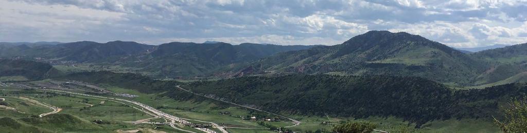
7 The Vision Surrounded by spectacular views, numerous parks and open space trails, and interesting geologic formations, the Rooney Valley is ideally situated to become a premiere location within the Denver Metropolitan Area. The Rooney Valley will be a vibrant, mixed-use, walkable community where residents, employees and visitors can celebrate the unique and beautiful natural features of the area, enjoy ample open space trails and parks, and shop in a variety of interconnected retail venues. Future development will create a community with a distinct character, provide for an array of services to meet the daily needs of the community, and protect and enhance the natural features and open space of the area. The Rooney Valley will radiate a vitality that will make it a special, unique and thriving place within the region. Chapter 1 7 Introduction The Rooney Valley is comprised of approximately 2,200 acres of land in three jurisdictions the Town of Morrison, the City of Lakewood, and unincorporated Jefferson County. It is ideally situated in the southwestern portion of the Denver Metropolitan Area and presents an outstanding opportunity for high-quality development. The Valley s proximity to the foothills, Rocky Mountains, numerous parks and open space trails, natural features including Red Rocks Park, Dinosaur Ridge and the Hogback, as well as Bandimere Speedway, and the charm of old Town Morrison, make it a very desirable place to live. Golden Denver Lakewood Jefferson County Rooney Valley Morrison Littleton Red Rocks Park Dinosaur Ridge Bandimere Speedway The Rooney Valley is located in the southwest of the Denver Metropolitan area and boasts views of the Hogback to the west and southwest Denver to the east.

8 Plan Rooney Valley 8 Photo courtesy of Randy Rooney The history of the Rooney Valley (the Valley) dates back to the early 1860s when the Rooney family homesteaded the area. At one time, the Rooney Ranch consisted of approximately 4,500 acres where the family raised Galloway cattle and Morgan horses. Alexander Rooney named his property the Iron Spring Ranch after the medicine spring used by migratory native-americans. In 1975, the Rooney home was placed on the National Register of Historic Places. Over time, the family sold a majority of its land holdings. Currently, there are numerous land owners in the Valley comprised of individuals, partnerships and corporations. Public owners include local, county, state and open space interests. Much of the land in the Rooney Valley was annexed into the City of Lakewood and the Town of Morrison in the 1980s due to anticipated development opportunities and speculation. The properties were annexed with property rights for high-density commercial and office development that provided for a maximum built out that theoretically would have allowed for 28 million square feet of building space in the Town of Morrison and City of Lakewood. Due to physical constraints, infrastructure limitiations and market conditions, there was very little development and the majority of land remains vacant. However, extensive existing zoning development rights for high-density commercial and office development remain on privately-owned properties in the City and Town. Purpose and Applicability of this Plan Plan Rooney Valley (Plan) is an advisory policy document developed jointly by the Town of Morrison (Town) and the City of Lakewood (City). This Plan was developed with input from the community, based on market conditions and emerging industry trends. It lays the foundation for appropriate decision making for any rezoning application in the Town or the City, as well as for any future annexations into either the Town or the City. It also provides the opportunity for joint planning to determine appropriate land uses, densities, open space and transportation networks as well as image and design of the Valley. The purpose of this Plan is to articulate the vision of the Valley by providing a solid foundation for policy direction, land use decisions and public investment.
9 Chapter 1 - Introduction The Plan ensures the Rooney Valley provides for: An interconnected transportation and open space system; The appropriate mix of residential housing types and densities; A balanced mix of land uses and appropriate development patterns that will allow the Rooney Valley to flourish; Provide opportunities for retail including potential large format and neighborhood serving uses; Efficient delivery of public services and infrastructure; and The protection of the area s natural features and open space. 9 Amending the Plan Any proposed modification to Plan Rooney Valley shall be processed as an amendment to the Plan, to be reviewed by the Project Management Team, Rooney Valley Commission, Lakewood City Council, and the Town of Morrison Board of Trustees. If an amendment is suggested, the Rooney Valley Commission, Council and Board must determine if the suggested change is in the best interest of the Town and City. An amendment to the Plan must be done by an adopted resolution of the Rooney Valley Commission and Lakewood Planning Commission in accordance with the City Charter following a public hearing before that Commission, and approval by the Morrison Board of Trustees (no hearing required) and Lakewood City Council as a resolution to include public comment, to be heard as a regular meeting agenda item. Plan Rooney Valley may be amended provided the following criteria are met: 1. The amendment improves the implementation of one of more of the guiding principles, goals or action steps of the Plan. 2. The amendment will not pose a detrimental impact on existing or planned Town or City facilities, services or transportation facilities. 3. Significant community concerns regarding the proposed change have been adequately addressed. Plan Organization Plan Rooney Valley is divided into four chapters, beginning with this introductory chapter. Chapter 2 provides a background of past and current planning efforts in Rooney Valley and a discussion of existing conditions, including existing zoning and the physical constraints and opportunities of this unique area. Chapter 3 describes the public planning process that was instrumental in developing the overall vision and guiding principles for the future of the Rooney Valley. Chapter 4 discusses the framework, goals and actions steps recommended for each Plan Element to ensure development is consistent with the community s vision and the market trends and forecasts.
10 Plan Rooney Valley How to use the Plan 10 The Plan is intended as a comprehensive yet flexible guide for residents, businesses, and property owners regarding future development in the Valley. For future residents and property owners, the Plan can help shape expectations about future use of property. For City and Town staff and officials, as well as the Rooney Valley Commission members, it will be used to evaluate development and project proposals to ensure that they align with the community s vision and the overall intent of the Plan. The vision for the Valley s future is embodied in six guiding principles. They serve as an important foundation for the Goals and Action Steps. Based upon an understanding of the market and from community input, the Guiding Principles identify the important characteristics that should define the future of the Rooney Valley and that must be incorporated in all future development. The six Guiding Principles are: Create walkable neighborhoods Provide for a range of neighborhood amenities and services Attract co-working opportunities or communal office options Preserve open space, natural beauty and views Establish the Rooney Valley as a place to live, shop, work and play Provide connectivity through a variety of transportation options
 which align with the Plan s Guiding Principles in order to achieve the vision for the")

11 Chapter 1 - Introduction At the core of Plan Rooney Valley are three Plan Elements, which address key areas of need in the Valley: Land Use and Design Transportation and Connectivity Open Space and Natural Features Within each Plan Element are a series of goals and implementation strategies (action steps) which align with the Plan s Guiding Principles in order to achieve the vision for the future. The Development Framework Map is the principal graphic component of Plan Rooney Valley that emerged from the community engagement efforts. Master Plan Decision-Making Roadmap It s not what the vision is, it s what the vision does. -Peter Senge 11 The plan contains three maps that serve as a guide for its recommended land uses, development pattern, connectivity and open space. The maps are: Development Framework Map: A map that identifies the proper mix and appropriate location for land uses for any rezoning in the Town or the City. It depicts the development framework and land use recommendations to achieve economic vitality, vibrant activity centers, and a sustainable mix of housing choices within the Rooney Valley. The Development Framework Map is accompanied by a Future Land Use Designations Chart (pages 12-13) that identifies appropriate land use and design characteristics for each land use category shown on the Development Framework Map. (Page 36) Transportation and Connectivity Map: A map to assist the City and Town achieve its vision for a convenient, connected and multi-modal transportation system. (Page 39) Open Space and Natural Features Map: Depicts the framework for open space and wildlife corridors, trail connectivity as well natural features throughout the Valley. (Page 42)
12 Plan Rooney Valley Future Land Use Designations Chart 12 The Future Land Use Designations Chart describes the characteristics and recommended land uses for each land use category, as well as design recommendations for neighborhood nodes, the special treatment area, and intersection gateways as shown on the Development Framework Map. Land Use Designation Low Density Residential Medium Density Residential Higher Density Residential Characteristics Land in this category serves as a transition from the dense, urban environment envisioned to the west of South McIntyre Street to surrounding low-density residential uses that surround the Valley on the north and east. It encompasses land best suited for lower intensities to connect to existing housing developments. Low-density residential neighborhoods are envisioned to incorporate ample open space, including the Central, Western and Eastern Open Space Corridors, as well as walkable services and amenities in close proximity. Uses are largely single-family residential development on a variety of lot sizes, with densities of three (3) to seven (7) dwelling units per one (1) acre. This land use category encompasses the land area directly west of South McIntyre Street, and provides an intermediate concentration between higher densities on the western edge and low densities to the east of McIntyre Street. Medium-density residential neighborhoods are envisioned to incorporate ample, shared private open spaces and the Western Open Space Corridor, as well as integrated commercial services and amenities. This land use designation encompasses a variety of residential development types, including higherdensity single-family development, duplexes, townhomes, and condominiums/apartments, accessory dwelling units and the like. Densities range from eight (8) to twelve (12) dwelling units per acre. This land use category sets forth the highest densities for residential developments along the western edge of the Rooney Valley, with direct access to the Western Open Space Corridor and Rooney Gulch with close proximity to commercial and neighborhood services. The integration of private/shared open spaces, community gathering areas and commercial services will be of fundamental importance to provide convenience and refuge to residents. New development within this land use designation will increase housing options for residents who seek a more compact, urban environment in proximity to commercial and office development and potential employment centers. This category designates areas for a range of residential use types, from single-family, clustered neighborhoods to multi-family development including tri-plexes, condominiums, townhouses and apartments. Residential densities are typically greater than twelve (12) dwelling units per acre. Commercial This land use category represents a broad mixture of commercial development to serve both local and regional markets and applies to commercial areas designated along main intersections of West Morrison Road, on the south side of the Rooney Valley. These areas will remain in the Town of Morrison and are appropriate for large scale retail uses, including but not limited to grocery stores, junior or discount department store anchors along with other commercial uses such as restaurants and bars, in-line retail, personal services, offices, event space, theatres, health clubs, and the like. The commercial land designated at West Morrison Road and South McIntyre Street is envisioned to function as a higher density mixed-use Town Center that has a strong civic component dedicated to the Town of Morrison. In order to facilitate development, buildings are more urban and higher intensity in the commercial area than west of C-470 provided that buildings feature exemplary design and transition to surrounding future residential uses. Particular emphasis will be placed on providing a civic component for the Town of Morrison within the Town Center commercial area. Mixed-Use This category encompasses a variety of future growth-oriented workplaces, located in the northwest corner of the Valley. This location is intended to accommodate development associated with employment uses and cooperative work spaces. The predominant uses include high-quality employment, office and commercial development types. Light industrial, business and office parks, and complementary uses that support employment, such as housing, retail, etc., may be incorporated where appropriate. Dwellings and offices are encouraged to locate above ground-floor retail and services. Development patterns should include both a vertical and horizontal mix of uses and provide for pedestrian amenities including plaza areas, seating areas and places for gathering. Special attention should be paid to ensure an appropriate balance of use types is achieved. Civic This category is designated for public and quasi-public facilities including, but not limited to, libraries, schools, civic buildings, hospitals, and other similar uses. The existing West Metro Fire Station and Town of Morrison Wastewater Treatment Facility are currently contained within this category. Approximately five (5) acres of land shall be dedicated to the Town of Morrison for municipal administration facilities within the commercial Town Center area located at West Morrison Road and South McIntrye Street. Parks & Open Space This land use category applies to existing areas along the Central and Western Open Space Corridors, Rooney Gulch, and surrounding open spaces such as the Eastern Open Space Corridor, William F. Hayden Park, Dinosaur Ridge and the Hogback. These corridors are intended to be used for outdoor recreation purposes, and special attention should be given to preserve the natural, scenic and historical features of the landscape which serve as the Valley s most prominent asset. Efforts for this designation should focus on maintenance and enhancement, and on improving interconnectivity between parks and open spaces and adjacent neighborhoods and amenities.


13 Chapter 2 - Background Future Land Use Designations Chart 93 Land Use Designation Neighborhood Node Dinosaur Ridge Visitor Center Characteristics Nodes are located strategically in close proximity to residential areas to ensure convenient access for residents and visitors to smaller-scale commercial and neighborhood services and amenities. Safe and attractive pedestrian and bicycle connectivity should be provided to and from the nodes to adjacent neighborhoods. Jefferson County Open Space ndimere edway Hog Back Rd. IGA Boundary Municipal Boundary S. Rooney Rd. W. Morrison Rd. Special Treatment Area Special Treatment Area Bear Creek Lake Park Jefferson County (As per Jefferson County Comprehensive Plan) Large Scale Commercial Low Density Residential Rural Residential S. McIntyre St. Intersection Gateways Special Treatment Area W. Wesley Ave Uses include a broad mixture of neighborhood amenities such as small-scale restaurants, coffee shops, pharmacies, bike shops, small boutiques, co-working spaces, public facilities (i.e. libraries and recreation centers) and pedestrian amenities (i.e. plaza areas, seating areas, and places for gathering for special events such as farmer s markets, entertainment and community events). Because of the substantial availability of open space corridors within the Valley, the intent is not to include parks and open space as predominant nodal features unless subordinate to other neighborhood-serving facilities being provided. Buildings can be up to 3 stories and should be oriented to the street, with parking located to the side or behind the buildings, and direct pedestrian access should be provided from public S. Indiana St. W. Alameda Pkwy. Coyote Gulch Park W. Yale Ave. Forsberg Iron Spring Park W. Iliff Ave. William F. Hayden Park sidewalks into the neighborhood node. The Special Treatment Area borders South McIntyre Street, between West Morrison Road and West Yale Avenue. This area is intended to highlight the major corridor that will run north-south through the area, and as such, will define the character of the surrounding neighborhoods and the Rooney Valley area. It serves as a gateway into the Rooney Valley and must serve as an inviting and pleasant interface that integrates the adjacent neighborhoods. The uses should correspond with the underlying land use category that is illustrated on the Development Framework Plan, and should incorporate aesthetic elements to improve the appearance within the Special Treatment Area. Any buildings or structures located within the Special Treatment Area should face South McIntyre Street to the greatest extent possible, with parking located behind or to the side of buildings. Fencing along McIntyre Street should be constructed of materials compatible with adjacent developments and should be at least 50% open. Fences should provide visual interest and architectural treatment (i.e. columns or enhanced landscaping) every 50 feet. Enhanced landscaping should be incorporated into adjacent development to create interest and enhance the character of South McIntyre Street, and should include, at minimum, trees and four-season plant materials. Provisions for safe, efficient and attractive pedestrian and bicycle connections should be included when South McIntyre Street is constructed and should include a 10 multi-use path on both sides of the street. An entry gateway should also be incorporated at the intersection of South McIntyre Street and West Morrison Road, which is intended to establish a distinct image for the Rooney Valley as a vibrant place to live, work, shop and recreate. Intersection Gateways correspond to major corridor entries into the Rooney Valley, including the intersections of C-470 and Alameda Parkway and South McIntyre Street and West Morrison Road. The Gateways will serve to establish a distinct image for the Rooney Valley as a vibrant place to live, work, shop and recreate. Jefferson County 13 County Land Use Designations County Large Scale Commercial The land use areas within unincorporated Jefferson County that lie within the Rooney Valley are represented pursuant to the the Jefferson County Comprehensive Plan. Descriptions of the applicable land use categories are provided below. Pursuant to Jefferson County s Central Plains Area Plan, the land located at the intersection of C-470 and Alameda Parkway is defined as Large Scale Commercial; further described as the C-470/Alameda Activity Center. The construction of the interchange at C-470 and West Alameda Parkway and recent rezoning cases have made the land surrounding the interchange prime for higher intensity uses. Land uses that create primary jobs are highly desired in this Activity Center. All retail on all four quadrants is not desired. This area is identified as large scale commercial and should allow for retail, office, light industrial, and multi-family residential uses. A portion of the northeast quadrant should also allow warehousing, including mini-warehouses. Reference the Jefferson County Central Plains Area Plan for more details. The County s large scale commercial land use located on the west side of C-470 contains the Bandimere Speedway and brings a significant regional draw. This category allows for retail and office uses of any size, hotels and motels, hospitals, and automobile dealerships. County Rural Residential County Low Density Residential Pursuant to Jefferson County s Central Plains Area Plan, the land located at the southwest corner of Alameda Parkway and Rooney Road is designated within the Rural Residential land use category. These properties currently range from approximately ¼ acre to over 2 acres. Large domesticated animals, such as horses, currently reside on many of the properties. These areas allow for horses or other livestock meeting specified guidelines or residential uses at a density of 4.5 dwelling units per acres. If this density is developed, large domesticated animals should not be allowed. The wildlife corridor along the floodplain area is encouraged to be left in a natural state, not channelized or piped, for the continued movement of wildlife. Reference the Jefferson County Central Plains Area Plan for more details. Pursuant to Jefferson County s South Plains Area Plan, a pocket of Jefferson County land is situated within the Valley, located just east of Rooney Valley Road and south of Yale Avenue, and is designated within the County for low density residential land use. New residential densities in this area should reflect less than four (4) dwelling units per one (1) acre. Reference the Jefferson County South Plains Area Plan for more details.

14 Plan Rooney Valley

15 Chapter 2 15 Background Planning in the Rooney Valley Planning for the area dates back to the late 1990s when the Town of Morrison and the City of Lakewood developed very similar Rooney Valley master plans. After the adoption of these plans, the City of Lakewood and the Town of Morrison realized the importance of coordinated planning in the area to ensure it is being developed in a thoughtful manner. The regional context and common vision of the Valley have united the Town and City in forwarding high quality development principles and integrated systems through joint planning efforts. The Rooney Valley Joint Master Plan (Master Plan) was adopted in 2002 by the City of Lakewood and the Town of Morrison. The Master Plan consolidated the individual plans that had been adopted by the Town of Morrison and the City of Lakewood in the late 1990s. The Master Plan articulated a vision, development tools and an implementation plan to guide development in the Rooney Valley. Since the adoption of the 2002 Master Plan, minimal development has occurred within the IGA area due to a number of factors including the (now resolved) Mt. Carbon bankruptcy, and water and infrastructure issues. Jefferson County Lakewood Morrison You ve got to think about big things while you re doing small things, so that the small things go in the right direction. -Alvin Toffer IGA Boundary
16 Plan Rooney Valley 16 What is an IGA? Intergovernmental Agreements, commonly referred to as IGAs, are contracts between governing bodies. They describe relationships, define authority, and seek to achieve efficiencies through mutual cooperation. Local governments typically enter into IGAs to solve problems of mutual concern like: Joint Master Plans Shared development review Revenue sharing Service delivery and maintenance Unified development standards Building on Previous Planning Efforts Comprehensive Plans are vision documents that set the direction for the future. The City of Lakewood s Comprehensive Plan, adopted in 2015, identifies the Rooney Valley as one of the few remaining areas in the City that is available for development. The Lakewood Comprehensive Plan recommends that the 2002 Rooney Valley Joint Master Plan be updated to ensure the Valley continues to develop in a thoughtful and cohesive manner. The Town of Morrison Comprehensive Plan, adopted in 2008, encourages highquality, mixed-use development within the Rooney Valley and identifies this area as a growth area that will generate revenue for the Town. Plan Rooney Valley represents a coordinated effort to solidify a joint vision for the Valley, comprehensively determine the appropriate balance of land uses, understand the market and area conditions and emerging industry trends, remove barriers to development, coordinate actions on annexations and the delivery of public services and infrastructure, identify revenue sharing opportunities, preserve special features of the Valley, and guide infrastructure investment and network connections. Intergovernmental Agreement In 2000, the Town and the City entered into an Intergovernmental Agreement (IGA). Although the Intergovernmental Agreement area includes a portion of Jefferson County, Jefferson County is not a party to the IGA. The IGA provided for joint planning for, among other items, appropriate land uses and densities, joint coordination of capital investment in infrastructure, land purchases and public features within the Valley. The IGA also included provisions for joint revenue sharing, the joint sharing of the costs of services, and for the coordination of annexations. The IGA was revised in 2016 for the main purpose of streamlining land entitlement procedures in the Rooney Valley, simplifying the revenue sharing parameters and process for certain revenues collected by the City and Town, and simplifying the process by which municipal services will be provided in the Valley. The 2016 IGA created a Rooney Valley Commission comprised of three members from Lakewood and three members from Morrison. The purpose of the Rooney Valley Commission is to hear rezoning and potential annexation applications that occur within the Intergovernmental Agreement Area. The 2016 IGA continues to provide for joint planning efforts to determine appropriate land uses and densities, joint coordination of capital investment in infrastructure and annexations, and joint revenue sharing. The IGA boundary area is illustrated graphically on page 15.
17 Chapter 2 - Background Rooney Valley Market Study Ricker Cunningham was retained by the City of Lakewood in 2015 to conduct a market study to better understand prevailing and anticipated market conditions in and around the Rooney Valley. The market study provides a foundation and serves as a resource to allow the Town and the City to make informed development decisions based on an understanding of market and area conditions and emerging industry trends. In addition, the market study served as a tool to inform the planning process and to guide the development of the Goals and Action Steps contained in Chapter The market study provided a thorough analysis of: The supply and demand conditions for the residential market; The interchange retail demand; Office and industrial markets demand; and The demand for select land uses and product types. Each of these are discussed in more detail in the following excerpts taken from the market study. Notable investment in the Valley over the last two decades has been largely limited to the Solterra development in the City of Lakewood. The Solterra development is located adjacent to the IGA boundary area, but is generally not within the IGA boundary. The market study identified a number of factors that continue to impact investment and development decisions and serve as barriers to investment. While the number and type of barriers differ from one location in the study area to another, as well as from one parcel to another, they all fall into one of the following six categories -- physical, regulatory, market (consumer profile and developer capacity), financial, political and organizational. The greatest barrier is physical due to the absence of infrastructure and services (water and sewer). Residential Market - Supply and Demand The market study projected more than 13,500 ownership units in demand in the Residential Trade Area over the next decade. The highest percent of demand is anticipated for units priced between $350,000 and $500,000 and over $500,000. The Residential Trade Area rental market is operating closer to Metro Area averages with a vacancy rate of 4.7%. With 2,100 rental units under construction in 2015 and 2016, and with demand for approximately 5,300 rental units over the next 10 years, there remain 3,200 units which will need to be delivered somewhere in the Residential Trade Area to address demand.
18 Plan Rooney Valley Current conditions within the Retail Trade Area are comparable to those in the Denver Metro Area in terms of vacancy, quoted rental, net absorption rates, and new construction activity. 18 Demand for commercial retail, service and restaurant space is derived from two principal sources -- expenditures by retail trade area residents made outside the area, otherwise referred to as leakage, and expenditures by new households resulting from growth. Twenty-year demand in the Retail Trade Area associated with the recapture of leakage is estimated to be 489,000 square feet (sf), with an additional 3.0 million square feet from household growth. Interchange Retail Demand These analyses specifically investigated conditions and support for grocery and general merchandise stores within a three-mile radius of each interchange. Current and anticipated household growth over the next 10 years for both the C-470 and Morrison Road and C-470 and Alameda Parkway three-mile trade areas were considered sufficient to support a grocery and/or general merchandise opportunity. However, depending on the ultimate development concept for the Valley and location of specific day- and nighttime activity generating uses, both interchanges will likely be well positioned to accommodate commercial development of some form. Finally, what will be equally as important as market demand will be the physical capacity and attributes of each area to the extent that they can address the access and visibility requirements of select retailers. Office and Industrial Markets Demand The Market Analysis suggests support for approximately 6.3 million square feet of new office space and 8.9 million square feet of new industrial space. There remains limited capital for new development of traditional office products, particularly those located in suburban markets and lacking access to transit. Whereas industrial has rental rates significantly lower than office rental rates, and given the comparatively high cost of land development, it may be difficult to make this type of product financially feasible. Flex office space, with higher rental rates, would likely have a better chance to succeed. The only other employment product type, corporate headquarter or corporate campus, would likely favor a location like the Rooney Valley with regional access to points north and south in the Metro Area, Downtown Denver and Denver International Airport via Highway C-470; proximity to the mountains, their resorts and sports offerings, and regional trail systems; and Rooney Valley s attractive natural setting. However, conditions exist which will potentially continue to preclude interest among these users if not resolved include the lack of: diversity in housing product types including executive housing and employee housing options; daily services, restaurants, and hotels; and, alternative forms of transit infrastructure.
19 Chapter 2 - Background Market Absorption Summary Demand for select land uses and product types in the respective Trade Areas over the next 20 years is summarized in Table 2.1. Land Use Type Residential (Units): Low High Low High Low High Single-family Detached 16,200 9% 11% 1,458 1, Single-family Attached 6,900 7% 9% Rentals 7,200 9% 11% Subtotal 30,300 2,589 3, Non-residential (Sq. Ft.) Trade Area Demand (20 years) Market Share Table 2.1 Rooney Valley Study Areas Absorption (Units/Sq. Ft.) Absorption (Acres) Retail 3,400,000 14% 16% 476, , Office 6,300,000 7% 9% 441, , Industrial 8,900,000 7% 9% 623, , Subtotal 18,600,000 1,540,000 1,912, Total Acres Market Study Conclusions The Rooney Valley offers an unprecedented opportunity in the Denver Metro Area for a high-quality, multi-use environment that offers immediate and regional access to the state s recreational offerings, area employment centers, and air and rail transportation services. A diverse, yet limited, inventory of non-residential product offerings that are primarily local-serving will complement several high-quality residential neighborhoods and offer a range of products that address both un-served and under-served markets in both the Trade Area and Metro Area as a whole. Based on an analysis of somewhat comparable land development projects throughout the Front Range, it appears that site development costs in the Valley are higher than similar costs in other greenfield and fringe areas. These higher costs are generally attributable to: Less developable acreage over which to spread site costs (impacts of slope/ topography); and The slope and topography constraints and lack of infrastructure. In addition to financial resources, it is advisable that relevant policy and regulating documents between the participating jurisdictions are in alignment with the vision and desired outcomes. This may require either updates to existing documents, but regardless, ideally the shared goal will be to eliminate unnecessary barriers to investment.
20 Plan Rooney Valley 20 Density, as a component of entitlements, while often a solution to overcome economic challenges associated with development, might be considered a measure of last resort with other participatory measures used to balance private sector risk and return expectations and still accomplish high-value development. Given the Project Area s location at a highly visible gateway to all three jurisdictions, the Denver Metro Area to the east, and the Rocky Mountains to the west, improvements will ideally be mutually-beneficial and the cost of those improvements will be shared. This cost sharing arrangement could be formalized in new or updated agreements. Whereas some existing agreements, both intergovernmental and parcel-specific, have been considered to be less than productive relative to the evolving vision for the Valley and changing market conditions, a thorough review of each one and their supporting processes could benefit both public and private interests and eliminate any unintentional barriers to investment. Although each prospective stakeholder entity has a different role in the Valley s development, jointly prepared marketing and promotion materials and collective promotion could prove more efficient and valuable in the long term. Participating groups might include: City of Lakewood, Town of Morrison, Jefferson County, Jeffco ED, special districts (with a presence in the Valley), property and business owners, and developers. Since infrastructure challenges continue to play a significant role in delaying development in the Valley, a joint infrastructure strategy might be considered which: quantifies required service levels relative to existing resources based on a new vision for the Valley; identifies opportunities and locations for shared infrastructure improvements and offers a more comprehensive (and less redundant) and shared approach to cost allocation; and, considers existing agreements and their debt structure, so as to ensure the provision of uninterrupted services to area users. While the original Rooney Valley Master Plan envisioned a stronger mix of nonresidential to residential products, particularly west of the then planned McIntyre Street, it is the findings of the market research that primary uses in the Valley be residential, with a market-supported mix of non-residential uses, and primarily those that serve the needs and address the lifestyle preferences of existing and potential residents. Therefore, while the number of broad categories of uses might be fewer than originally conceived, a great variety of product offerings among these uses will be essential for success.


21 Chapter 2 - Background Existing Conditions Current Zoning Property in the IGA area currently is subject to a variety of zoning classifications from three governing bodies. The existing zoning in the Rooney Valley is comprised of planned developments, mixed use, residential and agricultural. As discussed in Chapter 1, the potential maximum (gross) build out of the original zoning would have allowed for 28 million square feet of building space within the Town and City that, due to the physical constraints of the Rooney Valley, current market factors, and infrastructure limitations, is not feasible. Throughout the planning process, net build out calculations were determined by evaluating constraints such as physical site conditions, infrastructure limitations, zoning ordinances and subdivision regulations to understand tangible development scenarios in the Valley. Approximately 8 million square feet of building space and 4,200 dwelling units could be developed within the Valley based on current zoning in place for planned developments, mixed use, residential and agricultural lands. 21 Geology and Soils Within the Valley there are major topographical and paleontological sites, soils with shrink/ swell potential, dipping bedrock conditions, major drainage corridors and open space, and other physical conditions that provide both opportunities and constraints for development within the Rooney Valley. There are some constraints on development due to the high shrink/swell soils in the Rooney Valley. Although the soils do not prohibit development, special care must be taken to mitigate the effects of the high shrink/swell soils in the area. The moderate to high swell potential soils are found in bands running parallel to the Current Zoning Hogback and C-470. Although the remainder of the soils are classified as having a low potential for shrinking and swelling, there is a chance that the soils may swell when wet and shrink when dry. Note: Not an official zoning map. For illustrative purposes only. An area in the northern portion of the Rooney Valley has a high potential for subsidence due to several abandoned mines as well as one active mine. General Shale continues to mine a portion of the area for materials to be used in the manufacture of bricks. The Golden Fault runs parallel to the Hogback and creates a minor concern for damage due to shifting and earthquake activity.
22 Plan Rooney Valley Due to the numerous soil and geologic conditions that may adversely affect development, all preliminary maps and final plats in the planning area will require greater site specific geotechnical foundation investigations to evaluate and remediate shrink and swell potential, subsidence, fault areas, soil strength, compressibility, liquefaction and steeply dipping bedrock. Topographical and Paleontological Resources 22 The area is fortunate to have a number of significant features. On the west is the Hogback, which is an excellent example of a geologic action that raised the rock and exposed the sedimentary layers to view. Dinosaur Ridge located on the northwest edge of the area contains fossilized dinosaur remains and is part of the Morrison-Golden Fossil Areas Natural National Landmark. Both the Hogback and Dinosaur Ridge provide a unique and beautiful setting for those living and visiting the area. Drainage Corridors and Open Space Generally, the Rooney Valley slopes from northwest to southeast toward Bear Creek Lake Park. There are four main drainage corridors in the area - the Eastern Corridor, Central Corridor, the Western Corridor and Rooney Gulch. These drainage corridors are major open space assets to the area and serve as wildlife corridors for coyotes, foxes and other animals frequenting the area. The drainage corridors also provide excellent opportunities for future pedestrian and bike connections. The Rooney Valley is bounded on three sides by major open space areas and parks. Bear Creek Lake Park, located to the south, is developed for active and passive recreation use. The Hogback area to the west provides easy access to open space. William Frederick Hayden Park is located to the north of Rooney Valley and is used for recreation such as hiking and biking. Visual Resources The views within the Rooney Valley are extensive and significant. Due to the elevations and openness within the Valley, there are expansive views of the Hogback to the west and southwest Denver to the east. Pikes Peak can be seen to the south of the Valley. The views are part of the appeal of those living in the Rooney Valley and protecting them is of great importance.
23 Page Intentionally Left Blank

24 Plan Rooney Valley


25 Chapter 3 25 Planning Process Four well-publicized community workshops were held beginning in March These meetings provided the opportunity to receive feedback from the community on the future vision and land use recommendations for the Rooney Valley. During the workshops, the community was updated on the history of the Rooney Valley, the market study, and the existing zoning in the Valley. A total of 216 individuals participated in these meetings including residents from the Town of Morrison and the Solterra and Tamarisk neighborhoods in Lakewood. Numerous hands-on activities were provided, including a mapping exercise to identify where residents shop, work and recreate. A number of workshops involved small group work. The Citizen Planner Challenge allowed participants to determine the best locations for employment uses, neighborhood and commercial nodes, as well as the best areas for additional residential development. The focus of the Citizen Planner Challenge was to ensure the recommended land uses matched, to the greatest extent possible, the recommendations contained in the market study. A survey was available both to those in attendance and those who wished to complete the survey online. The information gathered from the community workshops and the survey was posted on the City of Lakewood s website, the Town of Morrison Facebook page and the Rooney Valley Facebook page. The results of the survey identified what the community liked most about the Rooney Valley as well as what was missing from the area. Workshop participants identified access to parks, trails and open space; the scenic resources and views; and the location and convenience of the


26 Plan Rooney Valley 26 I would like the Rooney Valley to be a place where people can enjoy the outdoors in a quiet setting with natural ambiance Rooney Valley as the top three assets of the Valley. Places to shop, restaurants and dining, and neighborhood amenities and services were identified as the top three venues missing from the Valley. The community planning process and the invaluable input that resulted from the workshops and survey helped guide and develop the vision, the Guiding Principles, and the Goals and Action Steps for each Plan Element contained in Chapter 4. VISION -Survey Respondent I love having a home office but would love a space in my community to work collaboratively with other designers like me. -Workshop Participant Top 5 Elements of Community 1 Abundant parks, public places, and open space 2 Low crime rate 3 Walkable, mobile community design 4 Quality schools and educational opportunities Recreational opportunities 5 Top 3 Shopping Locations Why? BELMAR 71% 66%62% COLORADO MILLS GREEN MT/MARKET SQ. 30% 0% 5% 10% 13% 19% 23% TRANSPORTATION & MOBILITY 10 MINUTES OR LESS 11 TO 24 MINUTES 25 TO 34 MINUTES 35 TO 44 MINUTES 45 TO 60 MINUTES 60+ MINUTES THIS QUESTION DOESN T APPLY TO ME. QUALITY OF LIFE OVERALL QUALITY OF ENVIRONMENT COMMUNITY S VISUAL ATTRACTIVENESS SHOPPING Time Spent Commuting to Work (One Way) RECYCLING PROGRAMS NOISE LEVEL DRINKING WATER QUALITY CONSERVATION EFFORTS AIR QUALITY 92% of respondents drive individually Quality of the Environment 6 = Very Good, 5 = Good, 4 = Adequate, 3 = Bad Primary Means of Transportation WALKING BIKING DRIVE INDIVIDUALLY CARPOOL PUBLIC TRANSPORTATION OTHER
27 Page Intentionally Left Blank 27

28 Plan Rooney Valley
29 Chapter 4 29 Land Use and Design The Rooney Valley represents the last significant undeveloped land area in the West Denver Metropolitan region. In order for the Valley to become a vibrant community for future residents and businesses in the City of Lakewood and Town of Morrison, the communities are working together to chart a new course for the future by establishing a diverse mix of land uses and setting forth quality design principles to build and sustain a broad and resilient tax base for Lakewood and Morrison. Guided by community input and the market study, predominately residential uses are envisioned for the Valley ranging from the lowest densities on the eastern edge, adjacent to existing singlefamily neighborhoods, transitioning to medium densities in the core and higher densities along C-470 to the west. The residential base will be balanced by strategically located neighborhood nodes where mixed-use activity will be concentrated to create walkable neighborhoods providing a range of neighborhood amenities and services. Large scale, high-intensity commercial services are envisioned along the major intersections of Morrison Road, on the south side of the Rooney Valley, to provide vital retail services such as a grocery store, department store anchor, restaurants, offices and other regional-serving amenities. A mixed-use area is identified in the northwest corner of the Valley to accommodate development associated with employment uses and cooperative work spaces. Uses Neighborhood Node Collector Roadway Arterial Roadway Land Uses Low Density Residential Medium Density Residential High Density Residential Commercial Civic Open Space Trail Connection Bike Route 1/4 Mile


30 g Back Rd. Plan Rooney Valley Civic uses include the West Metro Fire Station and the Town of Morrison Wastewater Treatment Facility along West Morrison Road, and a future civic component within the commercial center at the intersection of West Morrison Road and South McIntyre Street. The Special Treatment Area for South McIntyre Street and designated Intersection Gateways are envisioned to provide an inviting and pleasant interface that integrates the adjacent neighborhoods as well as providing a distinct image for the Rooney Valley. 30 I would like The Rooney Valley to be a place where you can live, work, shop and participate in recreational activities. Right now we only have the live and recreational activities. -Survey Respondant Space 93 Mt. Vernon Ave. Bandimere Speedway Bear Cree Residential (Medium Density) Parking Special Treatment Area Cross Section S. Rooney Rd. S. McIntyre St. Amenity Zone Wesley Ave Special Treatment Area Special Treatment Area W. Morrison Rd. Travel Lanes Median Bear Creek Lake Park Travel Lanes Coyote Gulch Park W. Yale Ave. S. McIntyre St. (Special Treatment Area) Amenity Zone Area of Enlargement Typical Cross Section Special Treatment Area Residential (Low Density) Alley ROW Medium Density Residential Homes to Front McIntyre Street Low Density Residential Homes to Front McIntyre Street Alley Loaded Product S. McIntyre Median Median with Native Xeric Plantings Four-Season Plant Material S. McIntyre Amenity Zone 10 Multi-Use Path
31 Chapter 4 - Plan Elements Development Framework Map Buildout Projections Market analysis indicates that there is a need for a mix of land uses that capitalize on the Valley s natural environment and regional access. As such, the Valley could absorb approximately: 2,500 to 3,200 residential units; and 1.5 to 1.9 million square feet of retail and employment space. 31 The Development Framework Map identifies land uses for all areas within the IGA area. Table 4.1 summarizes the projected new residential and non-residential land uses and indicates the potential build-out of dwelling units and total square footages of non-residential land areas. These net build-out calculations were determined based on the future framework by evaluating constraints such as physical site conditions, infrastructure limitations, and anticipated zoning classifications to understand tangible development scenarios in the Valley. The table is based on Geographic Information System analysis of the Development Framework Map. How Does the Plan Measure Up? As illustrated in Table 4.1 below, approximately 1.9 million square feet of building space and nearly 5,000 dwelling units could be developed within the Valley based on proposed land uses for low density residential, medium density residential, high density residential, mixed use (commercial, light industrial, residential), commercial, civic, open space, and neighborhood node (mixed commercial and residential) designations. Land Use Type Residential (Units): Low Density Residential (Single-Family Detached) Medium Density Residential (Single-Family Attached) High Density Residential (Multi-Family) Subtotal Non-residential (Sq. Ft.) Commercial Light Industrial Civic Open Space Subtotal Rooney Valley Study Areas Absorption (Units/Sq. Ft.) 493 1,611 2,875 4,979 1,735, ,692 N/A N/A 1,911,231 Absorption (Acres) Total Acres Table 4.1 Table 4.1 represents a calculation of development potential as delineated in the Development Framework Map. Actual development proposals will need to be reviewed on a case-by-case basis within the entire context of the Development Framework Map.

32 Plan Rooney Valley 32 A large portion of the Valley, known as the Red Rocks Centre planned development, contains 345 acres under single ownership, and currently lies within the boundaries of the Town of Morrison. The Town and City are undergoing joint planning discussions with the landowner to potentially disconnect approximately 305 acres from the Town of Morrison, to be immediately annexed into the City of Lakewood such that development of all residential uses proposed for the Rooney Valley would take place in Lakewood rather than Morrison. The remaining 40 acres would remain within the Town of Morrison and serve as the Valley s prominent commercial center located at the northwest corner of West Morrison Road and South McIntyre Street. The potential Morrison disconnect and potential Lakewood annexation is illustrated in Figure 4.2 below. The Land Use and Design Element of this Plan is dependent upon the disconnect/annexation of the property. In the event that the disconnect/ annexation does not take place, the Plan will require an amendment. Proposed Property to Annex into City of Lakewood Property to Remain in Town of Morrison Figure 4.2 Disconnect / Annexation Illustration The land use and design goals contained in this element of the Plan aim to create a strong residential fabric while providing a diverse mix of land uses to help catalyze investment in the Valley. Action steps identify specific implementation strategies to promote a range of highquality residential housing options and supporting mixed uses, employment opportunities, civic facilities, commercial services and neighborhood nodes while emphasizing the natural beauty and views of the Valley. Supported by a strong, multimodal network and open space corridors, the Valley is positioned to be a desirable place to live, shop, work and play.
33 Chapter 4 - Plan Elements Goal 1: Develop the Rooney Valley with a balanced and diverse range of housing, retail and employment opportunities that will create a thriving area in which to live, work, shop and play. Action Step 1: Ensure all development and rezonings adhere to the Development Framework Map, the Future Land Use Designations Chart and any future agreements. Action Step 2: Develop appropriate incentives and tools to ensure the correct mix of uses is achieved consistent with the recommendations in the market study. 33 Action Step 3: Develop marketing and promotional materials to guide and promote the proper type of development and land use. Action Step 4: Research the feasibility of developing a comprehensive infrastructure plan for the Valley to assist with development. Action Step 5: Coordinate the potential disconnect and annexation strategy for Red Rocks Centre planned development in accordance with the Development Framework Map. Development/Annexation Agreements shall be required to ensure the principles set forth within the Plan are achieved. Action Step 6: Encourage owners of property within the Intergovernmental Agreement boundary that are in unincorporated Jefferson County to annex such properties into the Town or City in accordance with the Intergovernmental Agreement to implement joint planning efforts. Convey the availability of the Town of Morrison s wastewater services to serve future development. I would like The Rooney Valley to be a place where we can go to a beer garden and enjoy the views. -Survey Respondant Action Step 7: Work with local brokers and developers to identify and attract a grocery store, department store anchor, restaurants, offices and other regional-serving amenities in the southern portion of the Valley. Action Step 8: Market commercial lands as designated on the Development Framework Plan in partnership with developers and brokers. Action Step 9: Build relationships with area economic development organizations to advance economic development aspirations. Action Step 10: Require a mix of housing types and densities within new residential development to create a sustainable community where residents can live and work.
34 Plan Rooney Valley Goal 2: Establish a strong image and character for the Rooney Valley. Action Step 1: Update the Joint Rooney Valley Development Standards and other policy or regulatory documents for consistency with the Development Framework Map, as well as the Goals and Action Steps of Plan Rooney Valley. 34 Action Step 2: Require design of intersection gateways as shown on the Development Framework Map. These gateways should establish a distinct image for the Rooney Valley as a vibrant place to live, work, shop and recreate. Action Step 3: Ensure development, buildings and the public realm are of high quality design consistent with the Goals and Action Steps of Plan Rooney Valley. Apply the Joint Rooney Valley Development Standards to all development. Action Step 4: Design and develop South McIntyre Street as a key corridor through the Valley in accordance with the Special Treatment Area shown on the Development Framework Map and described in the Future Land Use Designations Chart. Action Step 5: Ensure development maximizes the ability for public enjoyment of the Valley s significant views through the orientation of buildings and incorporation of outdoor patios, balconies, and other public gathering spaces. Action Step 6: Encourage the use of signage that minimizes visual competition, does not dominate the streetscape, and results in attractive signs, while meeting business needs. Action Step 7: Encourage Valley-wide public art, such as sculptures and interpretive signs that pay tribute to the Valley s history.
35 Chapter 4 - Plan Elements Goal 3: Create walkable, pedestrian-friendly neighborhood centers to help shape new growth and development. Action Step 1: Encourage the development community to construct neighborhood nodes that include smaller-scale commercial and neighborhood services and amenities within walking distance of residents who live in and near the neighborhood nodes as depicted on the Development Framework Map. Action Step 2: Encourage that development agreements include provisions for neighborhood-specific civic, commercial and community amenities that are appropriately scaled to the area, meet the needs of future residents, and contribute to neighborhood character. 35 Action Step 3: Work with our partners to identify and develop a range of incentives to encourage new development to incorporate neighborhood node concepts and amenities (community, commercial, civic, and recreational) as depicted on the Development Framework Map.
36 Plan Rooney Valley Dinosaur Ridge Visitor Center William F. Hayden Park W. Alameda Pkwy. Forsberg Iron Spring Park DEVELOPMENT FRAMEWORK MAP Jefferson County Open Space 93 Hog Back Rd. Bandimere Speedway S. Rooney Rd. S. McIntyre St. W. Wesley Ave Special Treatment Area S. Indiana St. Special Treatment Area W. Iliff Ave. Coyote Gulch Park W. Yale Ave. Mt. Vernon Ave. Bear Creek Ave. W. Morrison Rd. Bear Creek Lake Park Legend Town of Morrison and City of Lakewood Low Density Residential Commercial Neighborhood Node IGA Boundary Jefferson County (As per Jefferson County Comprehensive Plan. Shown for reference only. Not a part of the Plan.) Medium Density Residential Civic Roadway Network Municipal Boundary Large Scale Commercial High Density Residential Open Space Future Civic Low Density Residential Mixed Use Existing Open Space Intersection Gateway Rural Residential Miles 0 1/8 1/4
37 Chapter 4 - Plan Elements Transportation and Connectivity The Rooney Valley is situated at the foot of the Hogback and is easily accessible from Colorado State Highway 470, West Alameda Parkway and State Highway 8 (West Morrison Road). The primary corridor providing north/south connectivity through the Valley is South McIntyre Street. This corridor presents some design challenges in that it will require a 170-foot right-of-way to accommodate the existing Public Service Company of Colorado (PSCO)/Xcel Energy power line tower/transmission line. 37 Most residents in the Rooney Valley area use the automobile as their primary mode of transportation. Through the community engagement process, a desire to provide for additional transportation options emerged. As such, multi-modal access to neighborhoods, retail services, employment, transit and area amenities is essential to providing for a high quality of life and economic vitality. The Rooney Valley provides an outstanding opportunity to provide a network of trails, both for pedestrians and bicyclists, while also providing a safe and interconnected street system. The Goals and Action Steps identified for this Plan Element are focused on the importance of a connected multi-modal transportation system to ensure the Valley develops in a cohesive manner that equally addresses all modes of transportation. Transportation and connectivity features are graphically depicted on the Transportation and Connectivity Map and illustrate a connected system of major roadways, major access points and intersections, existing and proposed pedestrian over/under passes and the overall transportation network. The street network is envisioned to be more than a way to move traffic. Streets should enhance the pedestrian environment. Buildings and building entrances should face the street, should offer a welcoming environment to the pedestrian, and should be of quality design to support the community character and shape the civic design of the Valley. Goal 1: Develop a multi-modal transportation system that provides safe, efficient and attractive options for pedestrian, bicyclists, vehicles and transit. Action Step 1: Develop a system of internally and externally interconnected streets, trails, pedestrian and bicycle paths in accordance with the Transportation and Connectivity Map, the Lakewood Bicycle System Master Plan and the Town of Morrison Community Trails Master Plan. Action Step 2: Establish and require level of service standards for all travel modes.
38 Plan Rooney Valley 38 I would like The Rooney Valley to be a place that has walkable, safe, shopping with restaurants and entertainment areas. Designed with outdoor gathering place. -Survey Respondent Action Step 3: Research the feasibility of developing a shuttle service between key locations throughout the Valley. This may include connections between Old Town Morrison, retail and commercial areas, civic amenities, historic resources, and recreational opportunities. Action Step 4: In partnership with the Regional Transportation District (RTD), identify an appropriate location for a future multimodal transit facility. The facility should serve as a transit center for RTD and any future shuttle, as well as provide parking for visitors to the Valley. Action Step 5: Require all development and rezonings within Lakewood to install transportation improvements in accordance with the City of Lakewood Transportation Engineering Design Standards and a traffic impact analysis. Action Step 6: Update the Joint Rooney Valley Development Standards and other policy and regulatory documents for consistency with the Transportation and Connectivity Map as well as Goals and Action Steps of this Plan. Action Step 7: Pursue updates to policy and regulating documents between the Town and the City relating to cost sharing for improvements. Develop a more comprehensive and shared approach for infrastructure improvements. Action Step 8: Require multi-modal transportation connections and options to neighborhood nodes, especially bicycle and pedestrian connections. Action Step 9: Develop or partner to develop a program that promotes carpooling and alternative mode commuting.

39 Chapter 4 - Plan Elements Dinosaur Ridge Visitor Center William F. Hayden Park 93 W. Alameda Pkwy. 39 Jefferson County Open Space 93 Hog Back Rd. Mt. Vernon Ave. Bandimere Speedway S. Rooney Rd. S. McIntyre St. W. Wesley Ave Forsberg Iron Spring Park S. Indiana St. W. Iliff Ave. Coyote Gulch Park W. Yale Ave. TRANSPORTATION AND CONNECTIVITY MAP Bear Creek Ave. W. Morrison Rd. Bear Creek Lake Park Legend Existing Arterial Roadway Future Arterial Roadway (Off-Street Multi-Use Paths) Existing Collector Roadway Future Collector Roadway (On-Street Bike Lanes) Existing Trail Under / Overpass Future Trail Under / Overpass IGA Boundary Municipal Boundary Future Trail Connections Existing Trail Connections Miles 0 1/8 1/4
40 Plan Rooney Valley Open Space & Natural Features 40 I would like The Rooney Valley to be a place where the open spaces remain a reminder of the history of Morrison and our state. Access to outdoor recreation remains in tact. Morrison improves or maintains its identity and history. -Survey Respondent The Rooney Valley is known for its majestic views and natural features. It is flanked by 5,000 acres of open space in the City of Lakewood; William F. Hayden Park to the north, Bear Creek Lake Park to the south; and thousands of acres of Jefferson County open space to the west. Natural features such as the Hogback and the Morrison-Golden Fossil areas, historic Rooney Ranch and Dinosaur Ridge all contribute to the unique setting for residents and visitors alike. Four main drainage corridors frame the open space network and serve as major open space assets for people and wildlife. These corridors are intended to be used for outdoor recreation purposes, and special attention is given to preserve the natural, scenic and historical features of the landscape, which serve as the Valley s most prominent asset as well as connect the major open spaces areas. Maintaining and enhancing the natural beauty and open space provides the opportunity to develop an interconnected system of open space for passive and active recreational use and wildlife activity, to be stewards of the unique environment and historic natural resources, and to support the high quality of life residents in the area enjoy. Existing and proposed open space and natural features are graphically depicted on the Development Framework Map and Open Space and Natural Features Map. They represent a continuing framework of open space systems within the Rooney Valley to connect to facilities and amenities in the surrounding area such as the Eastern Corridor, Bear Creek Lake Park, William F. Hayden Park and Jefferson County open space. The Valley s Central and Western Corridors and Rooney Gulch provide green fingers to these regional networks and offer opportunities for trail and wildlife corridor interconnections, and provide recreational and preservation opportunities to promote healthy living and active lifestyles while highlighting the natural features that make the Valley special. Goal: Develop an integrated system of parks and open space that protects the natural environment and natural features of the Rooney Valley. Ensure that adequate open space and recreational opportunities are an integral part of development. Action Step 1: Develop an interconnected system of open space, trail connections and wildlife corridors throughout the Rooney Valley consistent with the Transportation and Connectivity Map and Open Space and Natural Features Map.
41 Chapter 4 - Plan Elements Action Step 2: Place buildings in such a way that the natural features and topography are protected. Action Step 3: Protect the views of the Hogback, Pikes Peak and southwest Denver by limiting the height of buildings and strategically locating them in appropriate areas. Action Step 4: Protect the Open Space Corridors as shown on the Development Framework Map for wildlife movement and trails. The minimum width of the Central Open Space Corridor should be 200 feet and the minimum width of Rooney Gulch Open Space Corridor should be 300 feet. 41 Action Step 5: Include environmentally-friendly policies and practices with all developments. This could include, but is not limited to, promoting LEED development, incorporating pervious pavement in plazas and public areas, promoting the use of solar panels and the use of drought tolerant and native landscaping materials in development. Action Step 6: Integrate private and public open space and public recreational facilities into all residential development including, but not limited to, parks, community gardens, play areas, and landscaped areas for community gathering and recreating. Action Step 7: Apply the land use characteristics in the Future Land Use Designations Chart to all future development. Action Step 8: Where new development is adjacent to major open space and natural features as identified in the Plan, pursue a Development Agreement/Annexation Agreement with the developer to guarantee construction of improvements and preservation of open space corridors in accordance with the Development Framework Map, Open Space and Natural Features Map and characteristics in the Future Land Use Designations Chart. Action Step 9: Recommend that new development includes adequate and appropriate furnishings and other amenities, such as benches, bicycle parking, bicycle repair stations, and recycling/ trash collection to support safety and enjoyment of all users. Action Step 10: Require site-specific geotechnical reports from developers and owners during the site planning process to evaluate and remediate geologic hazards and soils.


42 Plan Rooney Valley Dinosaur Ridge Visitor Center William F. Hayden Park W. Alameda Pkwy. OPEN SPACE AND NATURAL FEATURES MAP Jefferson County Open Space 93 Hog Back Rd. Mt. Vernon Ave. Bandimere Speedway Rooney Gulch S. Rooney Rd. S. McIntyre St. Western Corridor W. Wesley Ave Forsberg Iron Spring Park S. Indiana St. Central Corridor W. Iliff Ave. Eastern Corridor Coyote Gulch Park W. Yale Ave. Bear Creek Ave. W. Morrison Rd. Bear Creek Lake Park Legend Open Space and Wildlife Corridors Golden Fault Future Trail Under / Overpass Pedestrian Crossing Parks / Open Space Existing Trails and Bike Paths Existing Trail Under / Overpass Viewshed Neighborhood Node Future Trail Connections IGA Boundary Municipal Boundary Miles 0 1/8 1/4
Gold Line Bus Rapid Transit Transit Oriented Development (BRTOD) Helmo Station Area Plan
 Helmo Station Area Plan") Appendix F Gold Line Bus Rapid Transit Transit Oriented Development (BRTOD) Helmo Station Area Plan Introduction and Purpose of the Plan The Gold Line Bus Rapid Transit facility is an eleven-mile dedicated
Appendix F Gold Line Bus Rapid Transit Transit Oriented Development (BRTOD) Helmo Station Area Plan Introduction and Purpose of the Plan The Gold Line Bus Rapid Transit facility is an eleven-mile dedicated
CITY OF COLWICH COMPREHENSIVE PLAN LAND USE LAND USE 1
 LAND USE LAND USE 1 WHAT YOU WILL FIND IN THIS CHAPTER: Discussion of today s conditions and tomorrow s projections Discussion of challenges and opportunities Discussion of the environmental quality goals,
2.0 AREA PLANS. Lakeside Business District. Lakeside Business District Land Use Categories:
 Lakeside Business District Lakeside Business District Land Use Categories: Campus Commercial Campus Commercial means a mixture of uses which includes corporate offices, office parks, hotels, commercial,
Staff Report and Recommendation
 Community Planning and Development Planning Services 201 W. Colfax Ave., Dept. 205 Denver, CO 80202 p: 720.865.2915 f: 720.865.3052 www.denvergov.org/cpd TO: City Council Neighborhoods and Planning Committee
Urban Planning and Land Use
 Urban Planning and Land Use 701 North 7 th Street, Room 423 Phone: (913) 573-5750 Kansas City, Kansas 66101 Fax: (913) 573-5796 Email: planninginfo@wycokck.org www.wycokck.org/planning To: From: City Planning
Introduction. Chapter 1. Purpose of the Comprehensive Plan Plan Organization Planning Process & Community Input 1-1
 Chapter 1 Introduction Lakewood 2025: Moving Forward Together Purpose of the Comprehensive Plan Plan Organization Planning Process & Community Input 1-1 Purpose of the Comprehensive Plan The Comprehensive
CHAPTER 3 VISION, GOALS, & PLANNING PRINCIPLES. City of Greensburg Comprehensive Plan. Introduction. Vision Statement. Growth Management Goals.
 CHAPTER 3 VISION, GOALS, & PLANNING PRINCIPLES Introduction The Greensburg Comprehensive Plan is intended as a working community document. A combination of long and short-term goals, this document is intended
LAND USE OVERVIEW WHAT YOU WILL FIND IN THIS CHAPTER
 LAND USE WHAT YOU WILL FIND IN THIS CHAPTER Information about the City s expected population and employment growth. Description and capacity of existing and future land use designations. Policies that
Town Center (part of the Comprehensive Plan)
") Town Center (part of the Comprehensive Plan) Mercer Island Town Center Looking North (2014) In 1994, a year-long process culminated in a set of design guidelines and code requirements for the Town Center
Town Center (part of the Comprehensive Plan) Mercer Island Town Center Looking North (2014) In 1994, a year-long process culminated in a set of design guidelines and code requirements for the Town Center
Plan Overview. Manhattan Area 2035 Reflections and Progress. Chapter 1: Introduction. Background
 Plan Overview The Manhattan Urban Area Comprehensive Plan (the Comprehensive Plan) is a joint planning initiative of the City of Manhattan, Pottawatomie County, and Riley County. The 2014 Comprehensive
CHAPTER 7: Transportation, Mobility and Circulation
 AGLE AREA COMMUNITY Plan CHAPTER 7 CHAPTER 7: Transportation, Mobility and Circulation Transportation, Mobility and Circulation The purpose of the Transportation, Mobility and Circulation Chapter is to
Sheridan Boulevard S TAT I O N A R E A P L A N S H E R I D A N B O U L E VA R D S TAT I O N A R E A P L A N
 Sheridan Boulevard S TAT I O N A R E A P L A N 1 City of Lakewood Adopted November, 2006 S H E R I D A N B O U L E VA R D S TAT I O N A R E A P L A N The Vision The City of Lakewood s overall vision is
Ten Mile Creek Planning Area
 PLANNING AREA POLICIES TEN MILE CREEK Ten Mile Creek Planning Area Location and Context The Ten Mile Creek Planning Area ( Ten Mile Creek area ) is located south of the current Boise AOCI, generally south
C. Westerly Creek Village & The Montview Corridor
 C. Westerly Creek Village & The VISION Community Vision When the goals of the city are achieved Westerly Creek Village, a distinctive community defined by Montview Boulevard and Westerly Creek, is a strong
2040 LUP is a part of the Comprehensive Plan and carries the same legal authority. Economic Challenges
 1.1. Guiding Anchorage s Growth Where will new residents settle over the next two decades? Where will people work, shop, and play? Will there be enough room to grow? How will Anchorage look? Will growth
IMPLEMENTATION STRATEGIES. In This Chapter. Goals & Strategies 182 Project List 183 Future Land Use 186 CHAPTER 11 IMPLEMENTATION STRATEGIES
 In This Chapter Goals & Strategies 182 Project List 183 Future Land Use 186 11 IMPLEMENTATION STRATEGIES NORTH AUGUSTA, SC 2017 COMPREHENSIVE PLAN 179 Individual commitment to a group effort that is what
9 th Street Sub Area Plan
 9 th Street Sub Area Plan In the 1990 s, when the Township prepared the last Master Plan, the 9 th Street corridor was studied as part of a larger 9 th Street Focus Area that included the West Main Street
The transportation system in a community is an
 7 TRANSPORTATION The transportation system in a community is an important factor contributing to the quality of life of the residents. Without a sound transportation system to bring both goods and patrons
3. VISION AND GOALS. Vision Statement. Goals, Objectives and Policies
 Vision Statement Queen Creek s interconnected network of parks, trails, open spaces and recreation opportunities provide safe and diverse activities and programs that sustain its unique, small town, equestrian
City of Golden. Annexation Study Area Report
 City of Golden Annexation Study Area Report July 2016 Adopted by Planning Commission Resolution No. PC16-11 City Council Resolution No. 2497 RESOLUTION PC16-11 A RESOLUTION OF THE CITY OF GOLDEN PLANNING
Staff Report to the North Ogden City Planning Commission
 Staff Report to the North Ogden City Planning Commission SYNOPSIS / APPLICATION INFORMATION Application Request: Concept review on a legislative application to rezone land located at approximately 1750
Lehigh Acres Land Development Regulations Community Planning Project
 Lehigh Acres Land Development Regulations Planning Effort Summary In July, 2010 Commissioner Frank Mann invited the Lehigh Acres community to start discussing how to achieve their recently adopted community
6 Growth Management Challenges and Opportunities
 6 Growth Management Challenges and Opportunities The Town has established a goal of attaining a 50% participation rate with respect to employment opportunities versus residential population. The Town s
Wadsworth Boulevard S TAT I O N A R E A P L A N
 Wadsworth Boulevard S TAT I O N A R E A P L A N City of Lakewood Adopted November, 2006 The Vision The City of Lakewood s overall vision is to transform the area around the light rail station into a mixed-use
MAYFIELD WEST SECONDARY PLAN PHASE 2
 MAYFIELD WEST SECONDARY PLAN PHASE 2 Public Open House #3 February 25, 2010 Draft Preferred Land Use Scenario TOWN OF CALEDON PLANNING & DEVELOPMENT DEPARTMENT Open House Agenda TOWN OF CALEDON 1. Welcome
Citizen Comment Staff Response Staff Recommended Revision Planning Committee
 Citizen Comment Staff Response Staff Recommended Revision Planning Committee Area No. 1: Owner desires retail land uses. Area No. 1a: Owner of two small parcels adjacent to Area No. 1 desires retail land
Town of Castle Rock DRCOG 2013 Annual Growth and Development Report. Introduction. Section 1 Metro Vision 2035
 Town of Castle Rock DRCOG 2013 Annual Growth and Development Report Introduction This is the Town of Castle Rock s sixth annual report to the Denver Regional Council of Governments (DRCOG) reporting on
1.0 Introduction. Purpose and Basis for Updating the TMP. Introduction 1
 1.0 Introduction The Town of Castle Rock is situated between the metropolitan areas of Denver and Colorado Springs, amidst a unique terrain of rolling hills, mesas, ravines, and waterways. Like many Front
Creating Complete Roadway Corridors:
 Creating Complete Roadway Corridors: The AASHTO Guide to Transportation Landscape Architecture and Environmental Design NCHRP Project 15-33 Status Report AASHTO Standing Committee on Design Technical Committee
Hockessin Community Redevelopment Plan
 Hockessin Community Redevelopment Plan 3.1 Introduction The Community Redevelopment Plan for the Village of Hockessin is the result of the people s vision for a distinct village center that serves as the
Additional information about land use types is given in Chapter 5. Design guidelines for Centers and Neighborhoods are given in Chapter 7.
 4. Place Types Introduction In Albemarle County s Development Areas, the Neighborhood is the fundamental unit of community planning. The County s Neighborhood Model, an adopted part of the Comprehensive
EXHIBIT A. Tax Increment Reinvestment Zone No. 1 (Town Center) First Amended Project Plan 1
 First Amended Project Plan 1") EXHIBIT A Tax Increment Reinvestment Zone No. 1 (Town Center) First Amended Project Plan 1 1 As amended by Resolution No. 2008-02-001(TR1R) of the Tax Increment Reinvestment Zone No.1, and approved to
EXHIBIT A Tax Increment Reinvestment Zone No. 1 (Town Center) First Amended Project Plan 1 1 As amended by Resolution No. 2008-02-001(TR1R) of the Tax Increment Reinvestment Zone No.1, and approved to
9 CITY OF VAUGHAN OFFICIAL PLAN AMENDMENT NO BOCA EAST INVESTMENTS LIMITED
 9 CITY OF VAUGHAN OFFICIAL PLAN AMENDMENT NO. 631 - BOCA EAST INVESTMENTS LIMITED The Planning and Economic Development Committee recommends the adoption of the recommendations contained in the following
General Location Annex, Rezone & Preliminary Plat Lansdowne Addition, Unit Three
 NEWFOUNDLAND I-5 Agricultural District Subject Site SUNDANCE ANDERSON Single Family Residential CHRISTY PUD Agricultural District Highway Business General Location Annex, Rezone & Preliminary Plat Lansdowne
Land Use Amendment in Southwood (Ward 11) at and Elbow Drive SW, LOC
 at and Elbow Drive SW, LOC") 2018 November 15 Page 1 of 10 EXECUTIVE SUMMARY This land use amendment application was submitted by Rick Balbi Architect on 2017 August 31 on behalf of Sable Developments Ltd, and with authorization from
2018 November 15 Page 1 of 10 EXECUTIVE SUMMARY This land use amendment application was submitted by Rick Balbi Architect on 2017 August 31 on behalf of Sable Developments Ltd, and with authorization from
EXISTING COMPREHENSIVE PLAN
 EXISTING COMPREHENSIVE PLAN Town Center Land Use Element: V. LAND USE POLICIES Town Center Mercer Island's business district vision as described in "Your Mercer Island Citizen-Designed Downtown" was an
PINE CURVE REZONING. Property does not meet criteria for open space preservation and is not a candidate for a park
 PINE CURVE REZONING BACKGROUND Purchased as two parcels in 2001 and 2002 Annexed and Zoned Greater Downtown District Historic Center September 25, 2002 and October 7, 2002 WHAT THE PROJECT IS AND IS NOT
Definitions. Average Daily Traffic Demand (ADT): The actual number or projected number of cars that pass a point in a 24-hour period.
: The actual number or projected number of cars that pass a point in a 24-hour period.") Definitions Access Management: A combination of physical techniques and transportation policies used to control the flow of traffic between roads and the surrounding lands. Alternative City Form Scenarios:
Definitions Access Management: A combination of physical techniques and transportation policies used to control the flow of traffic between roads and the surrounding lands. Alternative City Form Scenarios:
Review of Opportunity Area C Draft Comprehensive Plan and Draft BOS Follow-On Motions. Special Working Group Meeting March 4, 2015
 Review of Opportunity Area C Draft Comprehensive Plan and Draft BOS Follow-On Motions Special Working Group Meeting March 4, 2015 The slides that follow identify where the draft Comprehensive Plan has
CHUGIAK-EAGLE RIVER SITE-SPECIFIC LAND USE PLAN
 CHUGIAK-EAGLE RIVER SITE-SPECIFIC LAND USE PLAN JUNE 2010 Final Prepared for The Heritage Land Bank, Municipality of Anchorage by Agnew: :Beck Consulting www.agnewbeck.com 907.222.5424 Chugiak-Eagle River
AWH REPORT OF THE PLANNING AND DEVELOPMENT DEPARTMENT FOR APPLICATION FOR REZONING ORDINANCE TO PLANNED UNIT DEVELOPMENT
 AWH REPORT OF THE PLANNING AND DEVELOPMENT DEPARTMENT FOR APPLICATION FOR REZONING ORDINANCE TO PLANNED UNIT DEVELOPMENT MAY 8, 2014 The Planning and Development Department hereby forwards to the Planning
SECTION ONE: INTRODUCTION. introduction
 introduction 1 INTRODUCTION Since it was first established in 1843 as a trading post for the Hudson s Bay Company, Victoria has evolved into a Provincial capital city that is recognized across Canada and
DRAFT Subject to Modifications
 TREASURE COAST REGIONAL PLANNING COUNCIL M E M O R A N D U M To: Council Members AGENDA ITEM 8 From: Date: Subject: Staff May 19, 2017 Council Meeting Florida Department of Transportation Complete Streets
City of Tacoma Planning and Development Services
 Agenda Item D-3 City of Tacoma Planning and Development Services To: Planning Commission From: Stephen Atkinson, Associate Planner, Planning Services Division Subject: Land Use Designations - Phase 2 Meeting
Planning Districts INTRODUCTION
 INTRODUCTION To facilitate detailed examination of development prospects for all areas of the community, Delano has been divided into 14 planning districts. The location of these planning districts is
PINE CURVE REZONING. BACKGROUND Purchased as two parcels in 2001 and 2002
 BACKGROUND Purchased as two parcels in 2001 and 2002 WHAT THE PROJECT IS AND IS NOT A Rezoning establishes the land use standards for Annexed and Zoned Greater Downtown District Historic Center September
TEMPLE MEDICAL & EDUCATION DISTRICT
 City of Temple, Texas TEMPLE MEDICAL & EDUCATION DISTRICT 1 Description. The City of Temple joined in partnership with key public and private entities to jointly promote education and medical activities
Implementation Guide Comprehensive Plan City of Allen
 Implementation Guide 2030 Comprehensive Plan City of Allen DRAFT 2015 Implementation Guide Allen 2030 Comprehensive Plan INTRODUCTION The Comprehensive Plan serves as a guide for the growth and development
ARTICLE 6: Special and Planned Development Districts
 ARTICLE 6: Special and Planned Development Districts 6-10 Traditional Neighborhood Development (TND) District 6-10.10 Purpose and Intent The Traditional Neighborhood Development (TND) District provides
Creating Connecting Celebrating. Lamar Street Station Area Plan
 Creating Connecting Celebrating Lamar Street Station Area Plan City of Lakewood Adopted March 2010 Table of Contents Vision 1 Station Area Highlights 2 Lakewood Citizen Participation 3 Reflecting the Comprehensive
Dwelling Units Max 12 dwelling units per acre/min 8 dwelling units per acre. Development Mix 80% non residential/20% residential
 13. OSTEEN LOCAL PLAN Background: The Osteen Local Plan area is located in southwest Volusia County along the SR 415 corridor between Lemon Bluff Road and Acorn Lake Road and includes 3,990 acres. The
Midtown Greenway Land Use and Development Plan Executive Summary
 Midtown Greenway Land Use and Development Plan Executive Summary Introduction The Midtown Greenway Land Use and Development Plan sets policy direction for land use and development in the Midtown Greenway
Comprehensive Plan ADOPTED APRIL 2014
 Comprehensive Plan ADOPTED APRIL 2014 8 8. Outstanding Recreational & Cultural Opportunities We are proud of our community s parks and recreation system. Our community will ensure that the legacy of our
FUTURE LAND USE ELEMENT
 FUTURE LAND USE ELEMENT GOAL I: To create and sustain a great place to live, play, and prosper Objective 1: The City of Ocala shall incorporate the principles and strategies of the Ocala 2035 Vision into
Small Area Plan. South Gateway
 Small Area Plan Adopted May 12, 2008 South Gateway Purpose. The South Gateway Small Area Plan defines the City s expectations for the future of the southern entrance to the City at Interstate 85 and Highway
A. WHAT IS A GENERAL PLAN?
 I. Introduction A. WHAT IS A GENERAL PLAN? A general plan is the planning guideline for the future of a city. It contains goals and policies which regulate urban development, the protection of the natural
PUBLIC OPEN HOUSE SEPTEMBER 8 TH, 2010 CITY OF LETHBRIDGE DEVELOPMENT SERVICES
 PUBLIC OPEN HOUSE SEPTEMBER 8 TH, 2010 CITY OF LETHBRIDGE DEVELOPMENT SERVICES INTRODUCTION Why is the City creating the West Lethbridge Employment Centre Area Structure Plan? West Lethbridge Urbanization
3.0 PROJECT DESCRIPTION
 3.0 PROJECT DESCRIPTION 3.1 BACKGROUND Under California law (Government Code Section 65300 et seq.), every city and county is required to have a general plan. The general plan is to be comprehensive and
Illustration of Eastlake Farmer s Cooperative Grain Elevator. Chapter 5: implementation 5-1
 Illustration of Eastlake Farmer s Cooperative Grain Elevator Chapter 5: implementation 5-1 chapter 5: implementation Introduction The Eastlake Subarea Plan includes a wide range of recommendations intended
LAND USE ELEMENT. Purpose. General Goals & Policies
 LAND USE ELEMENT Purpose This Land Use Element contains the goals and policies necessary to support the City s responsibility for managing land resources and guiding development through implementing regulations,
13 THORNHILL YONGE STREET STUDY IMPLEMENTATION CITY OF VAUGHAN OPA 669 AND TOWN OF MARKHAM OPA 154
 13 THORNHILL YONGE STREET STUDY IMPLEMENTATION CITY OF VAUGHAN OPA 669 AND TOWN OF MARKHAM OPA 154 The Planning and Economic Development Committee recommends the adoption of the recommendations contained
Chapter 1.0 Introduction
 Chapter 1.0 Introduction 1.1 Background The North Metro commuter rail line is part of the RTD FasTracks regional transit system expansion program to build more than 100 miles of rail transit throughout
CITY OF LAKEWOOD 2012 THREE-MILE PLAN
 CITY OF LAKEWOOD 2012 THREE-MILE PLAN SECTION 1: INTRODUCTION This document constitutes the s Three-Mile Plan for the unincorporated area three miles in width around the City s perimeter, as required by
1.0 Purpose of a Secondary Plan for the Masonville Transit Village
 Report to Planning and Environment Committee To: Chair and Members Planning & Environment Committee From: John M. Fleming Managing Director, Planning and City Planner Subject: Masonville Transit Village
V. Vision and Guiding Principles
 V. Vision and Guiding Principles The Master Plan for the Powers Ferry Corridor seeks a foundation in the desires of the community. At times, various elements of the community offered opposing viewpoints,
RE-Imagining the Downtown Colorado Springs Master Plan
 RE-Imagining the Downtown Colorado Springs Master Plan 2016 APA Colorado State Conference October 25, 2016 Overview 8:00 Welcome, Introductions, and Overview 8:15 Downtown s Planning History 8:30 A Market
7Page 91 CLEMMONS COMMUNITY COMPASS 7 COMMUNITY CHARACTER
 7 Community Character The beauty of Clemmons won t necessarily be a reflection of our past, but our future. This quote from Comprehensive Plan Steering Committee member Wayne Dodson captures the essence
Policies and Code Intent Sections Related to Town Center
 Policies and Code Intent Sections Related to Town Center The Town Center Vision is scattered throughout the Comprehensive Plan, development code and the 1994 Town Center Plan. What follows are sections
East Corridor Final Environmental Impact Statement
 East Corridor Final Environmental Impact Statement Alternatives Considered Operating Plan The requirements for opening day operations versus year 2030 are based on ridership and operations. Opening day
17.11 Establishment of Land Use Districts
 17.11 Establishment of Land Use Districts 17.11.010 Purpose. To promote the health, safety, and general welfare of City residents and those who come to South Salt Lake to work, exchange commerce and recreate.
Applicant Name Phone / Fax / Address City State Zip Code . Property Owner Phone / Fax / Address City State Zip Code
 Master Development Plan Application Community Development Department City of Redmond 411 SW 9 th Street Redmond, Oregon 97756 541-923-7721 541-548-0706 FAX Master Development Plan Fee $38,862.52 File Number
East Bench Master Plan Update
 Community & Economic Development Office of the Director East Bench Master Plan Update To: From: Planning Commission Wayne Mills, Senior Planner Date: November 18, 2015 CC: Re: Nora Shepard, City Planning
EXECUTIVE SUMMARY DRAFT CHAPTER 1 INTRODUCTION EXECUTIVE SUMMARY
 CHAPTER 1 EXECUTIVE SUMMARY INTRODUCTION Through the joint efforts of the City of Tulsa planning staff and the Land Services division of Indian Nations Council of Governments (INCOG), the Berryhill Land
Secrest Short Cut and Monroe Expressway Small Area Plan AUGUST 29, 2018
 Secrest Short Cut and Monroe Expressway Small Area Plan AUGUST 29, 2018 Background and Process Monroe Expressway will be open by the end of 2018 Union County and Indian Trail identified a need to revisit
4. Shape Transitions. 4. Shape Transitions
 4. Shape Transitions 49 Zoning District Policies Overall Intent: Maintain neighborhood character by creating compatible transitions that minimize land use conflicts. Strategy: Define the character of zoning
PSRC REVIEW REPORT & CERTIFICATION RECOMMENDATION
 PSRC REVIEW REPORT & CERTIFICATION RECOMMENDATION KITSAP COUNTY COUNTYWIDE PLANNING POLICIES July 2, 2012 BACKGROUND A major emphasis of the Washington State Growth Management Act (GMA) is the need to
3.10 LAND USE SETTING PROJECT SITE EXISTING LAND USE DESIGNATIONS AND ZONING. General Plan Land Use Designations.
 This section of the Draft EIR addresses the existing land uses on and adjacent to the project site and discusses the potential impacts of the proposed project on existing land uses. Key issues addressed
Further input invited as Colchester Growth Strategy nears final phase
 IUE 3 / NOVEMBER 2015 Further input invited as Colchester Growth trategy nears final phase trathcona County is seeking public feedback as it enters the final phase of work on a Growth Management trategy
Official Plan Review
 Official Plan Review Summary Report - The Built Environment August 2014 Part 1: Introduction Planning for a healthy, prosperous and sustainable community is an important goal for our municipality. From
and services The protection and conservation of environmentally significant and sensitive natural heritage features and functions.
 6. Land Use 6.0 Preamble A healthy and livable city is one in which people can enjoy a vibrant economy and a sustainable healthy environment in safe, caring and diverse neighbourhoods. In order to ensure
Mississippi Skyway Preliminary Engineering Report
 EXECUTIVE SUMMARY Mississippi Skyway Preliminary Engineering Report CITY OF RAMSEY, MINNESOTA DECEMBER 2014 City of RAMSEY EXECUTIVE SUMMARY Project Need and Intent The Mississippi Skyway pedestrian bridge
Chapter 2: Vision, Goals and Strategies
 Chapter 2: Vision, Goals and Lake Elmo Today & Tomorrow Comprehensive Plan 2040 2 VISION, GOALS & STRATEGIES - DRAFT 4-6-2018 INTRODUCTION Comprehensive Plan Purpose Perhapse the most important objective
Town of Portola Valley General Plan. Nathhorst Triangle Area Plan
 Town of Portola Valley General Plan Amended December 10, 1997 Table of Contents Introduction... 1 Planning Area... 1 Objectives... 2 Principles... 2 Standards... 4 Description... 4 Community Commercial...
TOWN OF INNISFIL SPECIAL COUNCIL AGENDA OUR JOBS INNISFIL HEIGHTS WORKSHOP WEDNESDAY JANUARY 20, :30 P.M.
 January 13, 2016 TOWN OF INNISFIL SPECIAL COUNCIL AGENDA INNISFIL HEIGHTS WORKSHOP WEDNESDAY JANUARY 20, 2016 5:30 P.M. PLEASE REMEMBER TO TURN OFF CELL PHONES 1. OPENING OF MEETING BY THE MAYOR Opening
PLANNING COMMISSION REPORT
 PLANNING COMMISSION REPORT REZONING CASE NO. RZ-14-002 REPORT DATE: February 10, 2015 CASE NAME: 9990 W. Alameda Ave. Rezoning PLANNING COMMISSION DATE: February 18, 2015 ADDRESS OF REZONING PROPOSAL:
Purpose of the Master Plan
 Purpose of the Master Plan 4 Master Plan Purpose The Master Plan is a policy framework for decisions that affect the physical, social and economic environment of the Town. The Parker 2035: Master Plan
Beatties Ford Road & Mt. Holly-Huntersville Road Small Area Plan
 Beatties Ford Road & Mt. Holly-Huntersville Road Small Area Plan Town of Huntersville October 2005 Town of Huntersville Planning Department 101 Huntersville Concord Road Post Office Box 664 Huntersville,
Behnke Ranch Property, Pasco County: Master Plan Development Approach
 February 24, 2014 , Pasco County: Master Plan Development Approach Location & Program The (Legacy PUD) is located in southwest Pasco County along State Road 54 approximately 1.5 miles west of the Suncoast
3.1 community vision. 3.3 required plan elements
 Chapter 3 Community Form 3.1 community vision 3.2 Parks & landscaping concepts 3.3 required plan elements D R A F T 20 Community Form Chapter 3 3.0 Community form 3.1 community vision The Specific Plan
2.0 THE PLATINUM TRIANGLE VISION
 2.0 THE PLATINUM TRIANGLE VISION The envisions an exciting future for the area surrounding Angel Stadium of Anaheim, the Honda Center and The Grove of Anaheim. 2.1 Planning Principles In order to further
Welcome. Walk Around. Talk to Us. Write Down Your Comments
 Welcome This is an information meeting introducing the applications for proposed redevelopment of the Yorkdale Shopping Centre site at 3401 Dufferin Street and 1 Yorkdale Road over the next 20+ years,
COLVER ROAD INDUSTRIAL CONCEPT PLAN
 COLVER ROAD INDUSTRIAL CONCEPT PLAN A CONCEPTUAL LAND USE AND TRANSPORTATION PLAN FOR TA-4 AN URBAN RESERVE AREA OF THE CITY TALENT City of Talent Adopted by City Council Resolution No., June, 2015 PART
Corridor Vision. 1Pursue Minnehaha-Hiawatha Community Works Project. Mission of Hennepin County Community Works Program
 1Pursue Minnehaha-Hiawatha Community Works Project Minnehaha-Hiawatha Community Works is a project within the Hennepin Community Works (HCW) program. The mission of the HCW program is to enhance how the
Chapter 4. Linking Land Use with Transportation. Chapter 4
 Chapter 4 Linking Land Use with Transportation Chapter 4 59 Chapter 4 Linking Land Use with Transportation Community Design and Transportation Program Introduction Since the 1950s, the predominant development
Draft Memorandum #1: Goals and Vision for Revitalization
 Keizer Revitalization Plan Draft Memorandum #1: Goals and Vision for Revitalization Submitted to: City of Keizer April 12, 2018 (revised) Prepared By: Angelo Planning Group and Otak, Inc. Project No. 17482.A
New Partners for Smart Growth Conference February 5, 2010
 Dan Stroh, Planning Director City of Bellevue Planning and Community Development Bellevue, WA New Partners for Smart Growth Conference February 5, 2010 Summary of Project Long-range plan update for Bel-Red
[PLANNING RATIONALE] For Site Plan Control and Lifting of Holding Zone By-Law 101 Champagne Avenue. May 23, 2014
![[PLANNING RATIONALE] For Site Plan Control and Lifting of Holding Zone By-Law 101 Champagne Avenue. May 23, 2014](/thumbs/75/71599615.jpg "[PLANNING RATIONALE] For Site Plan Control and Lifting of Holding Zone By-Law 101 Champagne Avenue. May 23, 2014") [PLANNING RATIONALE] For Site Plan Control and Lifting of Holding Zone By-Law 101 Champagne Avenue May 23, 2014 Contents 1.0 Introduction... 2 2.0 Site Context... 2 2.1 Adjacent Uses... 2 Figure 1: Site
[PLANNING RATIONALE] For Site Plan Control and Lifting of Holding Zone By-Law 101 Champagne Avenue May 23, 2014 Contents 1.0 Introduction... 2 2.0 Site Context... 2 2.1 Adjacent Uses... 2 Figure 1: Site
Draft Cary Community Plan Review Part 3: Shop, Engage, Serve, Special Area Plans, Other Updates. October 27, 2015 Police Department Training Room
 Draft Cary Community Plan Review Part 3: Shop, Engage, Serve, Special Area Plans, Other Updates Committee for the Future October 27, 2015 Police Department Training Room AGENDA 1. Welcome and Call to Order
4. POPULATION, LAND USE, AND DEVELOPMENT
 WEATHERFORD GENERAL PLAN POPULATION, LAND USE, AND DEVELOPMENT ELEMENT 4. POPULATION, LAND USE, AND DEVELOPMENT 4. LAND USE AND DEVELOPMENT ELEMENT INTRODUCTION The Land Use and Development Element is
Living in Albemarle County s Urban Places
 Living in Albemarle County s Urban Places ALBEMARLE COUNTY, VIRGINIA A Closer Look at Albemarle s Approach to Managing Growth and Creating Quality Urban Environments www.albemarle.org Page 2 Living in