WestConnex M4-M5 Link Mini-EIS for Haberfield/Ashfield area
|
|
|
- Elfrieda McGee
- 5 years ago
- Views:
Transcription
1 WestConnex M4-M5 Link Mini-EIS for Haberfield/Ashfield area Need to read chapter 26 cumulative impacts Find worst case scenario notes why not in Wattle St section? Don t forget conveyor belt over Parramatta Road concept, mine shaft going down on Haberfield side Executive summary It is anticipated that the project would be constructed and opened to traffic in two stages. Stage 1 would include: Construction of the mainline tunnels between the M4 East at Haberfield and the New M5 at St Peters, stub tunnels to the Rozelle interchange (at the Inner West subsurface interchange) and ancillary infrastructure at the Darley Road motorway operations complex (MOC1) and Campbell Road motorway operations complex (MOC5) These works are anticipated to commence in 2018 with the mainline tunnels open to traffic in At the completion of Stage 1, the mainline tunnels would operate with two traffic lanes in each direction. This would increase to generally four lanes at the completion of Stage 2, when the full project is operational. What are the project objectives? The specific objectives of the project include: Linking the M4 East and New M5 motorways so that further benefits of, and opportunities arising from, WestConnex can be realised Improving traffic conditions and reducing congestion on key arterial roads in proximity to the project Improving accessibility and reliability for commercial vehicle movement in the M4 and M5 motorway corridors to economic centres, including to the Sydney Airport and Port Botany precincts Facilitating urban renewal in areas where the project would reduce traffic Minimising impacts associated with acquisition of residential and commercial properties Delivering a project with a beneficial urban design outcome Enabling long-term motorway network development by providing a connection to the proposed future Western Harbour Tunnel and Beaches Link project to the north. The objectives of the project are consistent with those of the WestConnex program of works, as stated in the WestConnex Updated Strategic Business Case (Sydney Motorway Corporation 2015). Construction impacts page x To minimise construction traffic impacts, the project s construction ancillary facilities that provide tunnelling support (and would therefore generate the most construction traffic) have been strategically located to provide direct access to and from major arterial roads where possible and the M4 East Motorway (when opened). Only limited on-site parking for construction personnel would be provided at the more constrained construction ancillary facilities. Opportunities to provide additional parking and minimise impacts on on-street parking around construction sites would be investigated during detailed design and construction planning.
2 The roadway level of service analysis carried out for the project indicates that construction traffic is forecast to reduce mid-block traffic level of service (LoS) at four locations: At two locations Wattle Street at Haberfield, east of Parramatta Road, and Darley Road Leichhardt, west of James Street the mid-block level of service drops but remains at an acceptable LoS C or LoS D On City West Link, west of Darley Road at Leichhardt, the eastbound mid-block level of service is forecast to decrease from LoS E to LoS F in the PM peak hour On City West Link, west of The Crescent at Lilyfield, the westbound mid-block level of service is forecast to decrease from LoS D to LoS E in the PM peak hour. The levels of service at intersections are not expected to be significantly impacted, with the exception of the Wattle Street/Ramsay Street, Dobroyd Parade/Timbrell Drive, City West Link/James Street and City West Link/The Crescent intersections. This is due to City West Link and Wattle Street being one of the key routes for construction traffic. Impacts due to temporary lane closures and speed reductions, particularly during traffic staging, would also occur. Management of potential impacts construction TOO LATE Prior to the commencement of construction, a Construction Traffic and Access Management Plan (CTAMP) would be prepared as part of the Construction Environmental Management Plan (CEMP). It would set out the approach that will be adopted to minimise delays and disruptions, and identify and respond to any changes required to ensure road safety. The CTAMP would propose a car parking strategy for construction staff at the various worksites, developed in consultation with relevant local councils and stakeholders and would identify measures to manage the movements of construction related traffic to minimise traffic and access disruptions in the public road network. Page xi Where the project would connect to the existing road network, increased congestion is forecast in parts of Mascot, along Frederick Street at Haberfield, Victoria Road north of Iron Cove Bridge, Johnston Street at Annandale and on the Western Distributor. Many of these areas would be improved when the full WestConnex program of works and the proposed future Western Harbour Tunnel and Beaches Link and Sydney Gateway projects, if approved, are completed. Page xiv Ground-borne noise from roadheader activity is expected to impact about 494 properties, mostly where the tunnel entry and exit ramps would approach the surface road network around the Wattle Street interchange, the Rozelle interchange, the Iron Cove Link and on the approach to the St Peters interchange. It is likely that the excavation by the roadheaders may be perceptible in the evening and during the night for up to about WestConnex M4-M5 Link xv Roads and Maritime Services Environmental Impact Statement 20 days at each affected receiver as the roadheader passes them, with exceedances of ground-borne noise goals at affected receivers during these periods. Page xix not enough urban renewal, active transport at our end. The project would provide pedestrian and cyclist bridges that would increase the opportunities for communities to connect and interact, contributing to community and social cohesion. A new pedestrian footpath and separated cycleway would be provided between Springside Street and the Bay Run at Byrnes Street on the western side of Victoria Road. A pedestrian and cycle land bridge at Rozelle Rail Yards would provide a north-south connection between Bicentennial Park, the Rozelle Rail Yards and beyond to Easton Park benefitting the communities in Annandale/Glebe and Rozelle.

3 Chapter 6 Construction work Page 6-4: The concept design considers two possible combinations for construction ancillary facilities around Haberfield and Ashfield. These are described and assessed in this EIS as Option A and Option B. The construction ancillary facilities that comprise these options have been grouped together and are denoted by the suffix a (for Option A) or b (for Option B) eg Wattle Street civil and tunnel site (C1a). The construction ancillary facilities that comprise these options have been selected to assist in informing the preferred combination of construction ancillary facilities that would be used to construct the project. The preferred combination would be determined during detailed design and would meet the environmental performance outcomes stated in the EIS and the Submissions and Preferred Infrastructure Report, satisfy criteria that would be identified in any relevant conditions of approval and manage environmental risks. Page 6-5 this doesn t mention the Option A tunnelling site indication that Option B is preferred? Stage 1 mainline tunnels The key elements of the project that would be constructed during Stage 1 include: Temporary access tunnels to provide construction access to the mainline tunnels from the following construction ancillary facilities: Parramatta Road West civil and tunnel site (C1b) at Ashfield Darley Road civil and tunnel site (C4) at Leichhardt Pyrmont Bridge Road tunnel site (C9) at Camperdown Campbell Road civil and tunnel site (C10) at St Peters Note from bottom of table above: Temporary and permanent facilities may change when the construction contractor is engaged and detailed construction methodologies are developed. hard to make sensible comments then! 6-41: No tunnel spoil would be removed to the surface via the Haberfield civil and tunnel site all spoil would be transported below ground via the M4 East mainline tunnels Parramatta Road West tunnel and civil site: An acoustic shed with a roller door would be established on the site to minimise noise from out-ofhours tunnelling and spoil handling. In addition, temporary noise mitigation measures may include noise barriers and other temporary structures such as site buildings, which would be positioned to minimise effects from noise on surrounding properties. Construction traffic would enter and exit the site to and from the western (northbound) carriageway of Parramatta Road via new driveways. Temporary traffic management measures would be established to enable access and egress arrangements. These would be detailed in a Construction
4 Traffic and Access Management Plan (CTAMP), which would be prepared to manage construction traffic associated with the project. not available yet. How is community consulted about this? 6-46: (PRW site) Spoil handling on the site would occur 24 hours a day, seven days a week, within an acoustic shed. Excavated spoil from tunnelling would only be stockpiled within the acoustic shed. Heavy vehicle movements associated with the removal of spoil from tunnelling would only occur via access and egress directly to and from Parramatta Road. Spoil removal outside standard construction hours would meet the relevant noise criteria. Further details about construction hours are included in section All reasonable and feasible work practices to meet the noise affected level, including for works outside recommended standard hours (as identified in the Interim Construction Noise Guideline (NSW Department of Environment and Climate Change (DECCW) 2009a) (ICNG)) will be applied. With the exception of emergencies, activities will not take place outside standard daytime construction hours without prior notification of local residents, businesses and the NSW Environment Protection Authority (NSW EPA). Good pages to read Chapter 6-35 to 6-50 Chapter 8 Traffic and Transport (SN to read) and need to read Appendix H (traffic and transport) p. 8-7 Traffic modelling scenarios Traffic modelling for the project assessed eight scenarios: Three scenarios without the project: The existing road network (2015) The road network at the year of opening of the project (2023) The road network 10 years after opening the project (2033) A construction scenario (2021) Two scenarios with the project: At the year of opening of the project (2023) 10 years after opening the project (2033) Two cumulative scenarios: 8-12 At the year of opening of the M4-M5 Link (2023) with NorthConnex, M4 Widening, M4 East, King Georges Road Interchange Upgrade and New M5 and the proposed future Sydney Gateway and Western Harbour Tunnel operational. The proposed future Western Harbour Tunnel (a component of the proposed future Western Harbour Tunnel and Beaches Link project) has been tested without a surface connection at Rozelle 10 years after opening of the M4-M5 Link (2033), with NorthConnex, M4 Widening, M4 East, King Georges Road Interchange Upgrade and New M5 and the proposed future Sydney Gateway, Western Harbour Tunnel and Beaches Link and the F6 Extension operational. Future year model development Based on the planned construction activities, a worst case construction traffic scenario was assumed to be the period of spoil removal from the tunnel construction during The current road network with the addition of the M4 East and New M5 was assumed for the road network in the construction
5 scenario. AM and PM peak hour models for 2021 were developed to assess the future performance of the road network during construction. In a similar way to the future operational demand volumes, the growth forecast by the WRTM was used to derive the background traffic demand for Construction traffic was then added to the background traffic. This was based on the proposed construction methodology as described in Chapter 6 (Construction work) including vehicle types, volumes and construction traffic routes to and from the various construction ancillary facilities. The performances of the intersections in the vicinity of the constructions ancillary facilities were then calculated Is this the same as in the M4 East EIS? Seems better LOS ratings that I remember Table 8-8 presents the modelled AM and PM peak hour LoS for key intersections in the vicinity of the Wattle Street interchange. The intersection performance analysis demonstrates that most of the key intersections perform acceptably in the AM peak hour, with the exception of the Parramatta Road and Wattle Street intersection. In the PM peak hour, results indicate that key intersections operate to an acceptable level under existing demand. Table 8-8 Wattle Street interchange: key intersection performance (LOS) 2015 AM and PM peak hour Key intersections AM peak hour PM peak hour Parramatta Road/Sloane Street B B Parramatta Road/Liverpool Road C B Parramatta Road/Dalhousie Street B B Parramatta Road/Bland Street B B Parramatta Road/Wattle Street E D Parramatta Road/Great North Road B B Parramatta Road/Arlington Street B B Frederick Street/Church Street B B Wattle Street/Ramsay Street C C Dobroyd Parade/Waratah Street A A City West Link/Timbrell Drive C D 8-44 car parking this EIS doesn t include details of car parking routes, traffic management etc. still to be developed. Good that a carpark is provided improvement on M4East, but not good enough that this detail is still to come A car parking strategy would be developed as part of the Construction Traffic and Access Management Plan (CTAMP) to limit impacts on parking for the surrounding communities. The strategy would be developed in consultation with local councils and stakeholders associated with public facilities adjacent to project sites, as well as with the M4 East and New M5 contractors (where relevant) to identify opportunities to access parking during their respective construction periods and once those periods are completed. The car parking strategy would include items such as forecasting of construction parking demand, review of existing parking supply and use on local streets in the area, impact on existing parking, consultation activities and proposed mitigation measures, such as management of workforce parking and transport, alternative parking arrangements and communication and engagement. This would include the identification of areas where there are high levels of existing parking demand around the construction ancillary facilities and works sites and identifying alternative car parking sites for use by
6 the construction workforce. Processes for monitoring, reporting and corrective actions would also be part of the strategy. Table 8-43 Indicative access routes to and from construction ancillary facilities Site Wattle Street civil and tunnel site (C1a) Haberfield civil and tunnel site (C2a) Northcote Street civil site (C3a) Parramatta Road West civil and tunnel site (C1b) Haberfield civil site (C2b) Parramatta Road East civil site (C3b) Heavy vehicles 1 Parramatta Road then Wattle Street via M4-M5 Link entry and exit ramps Below ground: via the WestConnex M4 East tunnels Above ground: Wattle Street (left-in, left-out) Parramatta Road (left-in, leftout) Parramatta Road (left-in, leftout) Alt Street (crossover between sites only) Wattle Street (left-in, left-out) Parramatta Road (left-in, leftout) Parramatta Road (left-in, leftout) Access and egress points Light vehicles Parramatta Road then Wattle Street northern (eastbound) carriageway (right in, right out) Wattle Street southern westbound) carriageway (left-in, left-out) Walker Avenue Parramatta Road Wolseley Street Wattle Street (left-out) Parramatta Road (left-in, left-out) Alt Street Wattle Street (left-in, left-out) Parramatta Road (left-in, left-out) Walker Avenue (left-in, left-out) Parramatta Road (left-in, left-out) Alt Street Bland Street Bad news that Muirs carpark to have access from Alt St and Bland St. Mustn t happen. Reference to construction ancillary facilities page 8-47 not true that only one to be used in construction, now hearing new variations of a hybrid model, or use of Muirs on Haberfield side The construction ancillary facilities that comprise these options have been grouped together in this EIS and are denoted by the suffix a (for Option A) or b (for Option B) eg C1a Wattle Street civil and tunnel site. Although both of these options have been assessed in this EIS, only one of these options would be used during construction. 8-51/52 Haberfield and Ashfield Option B Parramatta Road West civil and tunnel site (C1b) Location and construction activities The Parramatta Road West civil and tunnel site (C1b) would be located west of Parramatta Road from around Alt Street to Bland Street at Ashfield. The site would be used for tunnelling support during construction and would include temporary site offices, a workshop and storage facilities, a laydown area, entry and exit points for construction traffic, a temporary substation, temporary ventilation for the tunnels, a temporary water treatment plant and sediment pond, workforce amenities and car parking. A construction site for the M4 East project is located south of Bland Street on the western side of Parramatta Road. The construction activities at this location are expected to occur between 2018 and 2022.
7 Entry and exit Construction traffic would enter and exit the site to and from the western (northbound) carriageway of Parramatta Road via new driveways. There would also be a vehicle cross-over point on Alt Street to allow construction vehicles to move between the parts of this site that are on the northern and southern sides of Alt Street. Local road impacts Heavy vehicle impacts on local roads would be minimised with heavy vehicle access and egress taken directly to and from Parramatta Road. The cross-over on Alt Street is likely to cause minor impacts on motorists and pedestrians using Alt Street when construction vehicles are moving between the sites. These minor impacts would be minimised through construction traffic management measures (see section 8.5). Due to existing property driveways being able to be augmented for use during construction, there would be no loss of on-street parking on Alt Street or Bland Street, west of Parramatta Road. Haberfield and Ashfield Option B Haberfield civil site (C2b) Location and construction activities The Haberfield civil site would be located around the south-eastern corner of the Parramatta Road and Wattle Street intersection, extending along Parramatta Road between Wattle Street and Walker Avenue. This construction ancillary facility would use land that is currently being used as a construction ancillary facility for the M4 East project. The Haberfield civil site (C2b) would be used to support civil construction of a substation, and fitout of permanent operational infrastructure including the Parramatta Road ventilation facility (being constructed as part of the M4 East project). The site would include temporary site offices, workshop and storage facilities, laydown areas, ingress and egress for heavy and light vehicles, workforce amenities and car parking. The construction activities at this location are expected to occur between 2018 and Entry and exit Heavy vehicles delivering materials and equipment would enter and exit the site via the westbound Wattle Street carriageways. Light vehicles would enter and exit the site via Wattle Street and Walker Avenue. Local road impacts While Walker Avenue is a local road, around 90 daily light vehicle trips are expected to be accessing the site, and these trips are distributed between three access points. Therefore, the impact on Walker Avenue would be minor. The majority of workforce car parking for this area would be located at the Parramatta Road East civil site (C3b). Haberfield and Ashfield Option B Parramatta Road East civil site (C3b) Location and construction activities The Parramatta Road East civil site (C3b) would be located east of Parramatta Road at Haberfield between Alt Street and Bland Street. The Parramatta Road East civil site (C3b) would be used to support tunnelling construction activities that would occur at the Parramatta Road West civil site (C1b), and to provide construction workforce parking. The site would include temporary site offices, ingress and egress for light vehicles, workforce amenities and car parking. The construction activities at this location are expected to occur between 2018 and Entry and exit Heavy vehicles delivering materials and equipment would enter and exit via the southbound Parramatta Road carriageways. In addition to using the Parramatta Road access, light vehicles would also be able to enter and exit the site using the Alt Street and Bland Street access points. Local road impacts With about 150 daily light vehicle trips expected, split between the three access points, the potential
8 impact on Alt Street and Bland Street would be minor. Due to existing property driveways, there would be no loss of on-street parking on Alt Street or Bland Street, east of Parramatta Road Table 8-47 Option A 2021 AM peak hour intersection operational performance summary Cluster 1 Without construction With construction Intersection Volume Volume LoS (PCU) 1 (PCU) 1 LoS Parramatta Road Harris Road 2,550 B 2,650 C Parramatta Road Croydon Road Arlington Street 3,280 B 3,370 B Parramatta Road Great North Road 3,810 C 3,940 C Parramatta Road Frederick Street Wattle Street 4,880 D 4,940 D Parramatta Road Bland Street 2,870 F 2,870 F Wattle Street Ramsay Street 3,260 C 3,280 C Dobroyd Parade Waratah Street 3,470 B 3,650 B Dobroyd Parade Timbrell Drive Mortley Avenue 5,530 F 5,720 F Table 8-48 Option A 2021 PM peak hour intersection operational performance summary Cluster 1 Without construction With construction Intersection Volume Volume LoS (PCU) 1 (PCU) 1 LoS Parramatta Road Harris Road 3,040 B 3,240 C Parramatta Road Croydon Road Arlington Street 3,610 D 3,710 E Parramatta Road Great North Road 3,820 F 3,920 F Parramatta Road Frederick Street Wattle Street 4,950 E 5,200 E Parramatta Road Bland Street 2,500 B 2,520 B Wattle Street Ramsay Street 3,080 D 3,330 E Dobroyd Parade Waratah Street 2,960 B 3,240 B Dobroyd Parade Timbrell Drive Mortley Avenue 5,450 F 5,770 F Table 8-50 Active transport impact severity criteria Option B Table 8-52 Option B 2021 AM peak hour intersection operational performance summary Without construction With construction
9 Cluster 1 Intersection Volume Volume (PCU) 1 LoS (PCU) 1 LoS Parramatta Road Harris Road 2,550 B 2,640 B Parramatta Road Croydon Road Arlington Street 3,280 B 3,360 B Parramatta Road Great North Road 3,810 C 3,900 C Parramatta Road Frederick Street Wattle Street 4,880 D 4,970 D Parramatta Road Bland Street 2,870 F 2,930 F Wattle Street Ramsay Street 3,260 C 3,300 C Dobroyd Parade Waratah Street 3,470 B 3,650 B Dobroyd Parade Timbrell Drive Mortley Avenue 5,530 F 5,720 F Table 8-53 Option B 2021 PM peak hour intersection operational performance summary Cluster 1 Without With construction construction Intersection Volume Volume (PCU) 1 LoS (PCU) 1 LoS Parramatta Road Harris Road 3,040 B 3,180 C Parramatta Road Croydon Road Arlington Street 3,610 D 3,750 E Parramatta Road Great North Road 3,820 F 3,960 F Parramatta Road Frederick Street Wattle Street 4,950 E 5,090 E Parramatta Road Bland Street 2,500 B 2,640 B Wattle Street Ramsay Street 3,080 D 3,120 D Dobroyd Parade Waratah Street 2,960 B 3,260 B Dobroyd Parade Timbrell Drive Mortley Avenue 5,450 F 5,750 F Table 8-54 Indicative temporary road network modifications during construction Option B Location Indicative road network modifications Indicative duration Road reinstatement Parramatta Works would be carried out on Alt Street Q to Once road Road West and Bland Street to facilitate access via new Q to modification works civil and driveways to the Parramatta Road West civil complete road are complete, both tunnel site and tunnel site (C1b) and the Parramatta modification. lanes along Alt Street (C1b) and Road East civil site (C3b) and/or Bland Street Q to Parramatta Temporary closures of one lane of Alt Street would be reopened Q Road East and Bland Street (either side of Parramatta in line with temporary including civil site (C3b) Road) may be required for establishment of design. When construction construction is construction vehicle access provisions duration and complete, the road including installation of driveways and reinstatement would be reinstated associated construction activities. Traffic of roads as per the existing management, that could include temporary arrangement diversions, would be implemented during temporary closures Due to existing property driveways, there would be no loss of on-street parking on Alt Street or Bland Street
10 Walking and cycling An increase in heavy vehicle volumes during the construction period in the project footprint and surrounding areas would potentially impact walking and cycling amenity. There are no planned diversions to pedestrian footways and cycling paths during construction for the three Option B construction sites. The Parramatta Road West civil and tunnel site (C1b) has a proposed heavy and light vehicle crossover on Alt Street and the Parramatta Road East civil site (3b) has proposed light vehicle entries and exits on Alt Street and Bland Street. Although this section of Alt Street is not a designated onroad cycle route, cycle logos are painted on Alt Street close to Parramatta Road. Periodic, short-term closures of footpaths on both sides of Alt Street on the eastern and western sides of Parramatta Road may be required. These would be most likely to occur during site establishment, when access to these sites is being established. Where a footpath is temporarily closed, the corresponding footpath on the other side of the road would remain open. While the volume of vehicles forecast to use these are low, minor impacts are anticipated during construction at these two sites as, while no diversions are required, there may be a safety impact. Traffic management measures would be implemented at the entry and exit driveways on Parramatta Road, Alt Street and Bland Street to manage potential interactions between construction traffic and pedestrians and cyclists Table 8-81 Wattle Street interchange: key intersection performance (LoS) 2015 Base, 2023 and 2033 without project and with project scenarios Key intersections base without with without with case project project project project AM peak hour Parramatta Road/Sloane Street B B B B C Parramatta Road/Liverpool Road C C C C C Parramatta Road/Dalhousie Street B B B C B Parramatta Road/Bland Street B B B C B Parramatta Road/Wattle Street E C E C E Parramatta Road/Great North Road B B B B B Parramatta Road/Arlington Street B C C C D Frederick Street/Church Street B B C B C Wattle Street/Ramsay Street C C C C C Dobroyd Parade/Waratah Street A A A B B City West Link/Timbrell Drive C D D F D PM peak hour Parramatta Road/Sloane Street B B B F C Parramatta Road/Liverpool Road B F C F E Parramatta Road/Dalhousie Street B B B B B Parramatta Road/Bland Street B B B B B Parramatta Road/Wattle Street D D D D D Parramatta Road/Great North Road B B B B B Parramatta Road/Arlington Street B C C C D
 9.1 Introduction (page 9-1) Sets out the environmental assessment requirements for the project, known as the Secretary s Environmental Assessment Requirements (SEARs). 9.2 Assessment Approach (page 9-3) page 9-5")
11 Frederick Street/Church Street B B B B B Wattle Street/Ramsay Street C C C C C Dobroyd Parade/Waratah Street A B A B A City West Link/Timbrell Drive D F E F F Chapter 9/10 Air quality Chapter 9 Air Quality (Part 1) 9.1 Introduction (page 9-1) Sets out the environmental assessment requirements for the project, known as the Secretary s Environmental Assessment Requirements (SEARs). 9.2 Assessment Approach (page 9-3) page 9-5
 page")
12 9.3 Construction Assessment Methodology (page 9-15) 9.4 Operational Assessment Methodology (page 9-17) page 9-22:

13

14 page 9-24 [Note: Haberfield Public School is CR35]

15 page 9-29
16

17 9.5 Existing Environment (page 9-32) Terrain data for Sydney was obtained from the Advanced Spaceborne Thermal Emission and Reflection Radiometer (ASTER) website. The terrain within the WestConnex GRAMM domain is shown on Figure 9-8 and is predominantly flat, but increases in elevation to the north of the Five Dock Bay area towards the Hills District and to the south towards the Sutherland Shire and adjoining parkland. The terrain along the project corridor varies from an elevation of around 10 metres Australian Height Datum (AHD) at the western end of the M4-M5 Link to an elevation of around 14 metres AHD at the Rozelle interchange and 10 metres at St Peters, at the southern end. The uniformity of the terrain, and the lack of major geographical obstacles to wind flow, should support good dispersion and airflow throughout the study area.
.")
18 9.6 Assessment of potential construction impacts (page 9-43) The concept design considers two possible combinations for construction ancillary facilities around Haberfield and Ashfield. These are described and assessed in this EIS (Option A and Option B). The construction ancillary facilities that comprise these options have been grouped together and are denoted by the suffix a (for Option A) or b (for Option B) eg C1a is Wattle Street civil and tunnel site. The preferred combination of construction ancillary facilities would be determined during detailed design and would meet the environmental performance outcomes stated in the EIS and the Submissions and Preferred Infrastructure Report, satisfy criteria that would be identified in any relevant conditions of approval and manage environmental risks. The construction activities in several of the construction ancillary facilities are expected to take place concurrently and in close proximity to one another. Therefore, for the assessment the construction ancillary facilities were combined according to the seven worst case scenarios listed in Table 9-14 [Note: this means Option A is known in the balance of the chapter as Scenario 1, and Option B is Scenario 2. In the following text, receptors seems to refer to the number of people who may be exposed to air contaminants. The assessment assumes 500 people in any school that is affected, this is an significant underestimate in the case of HPS].

19 (page 9-44) The number of receptors in each distance band from construction sites was estimated from land use zoning of the site. The exact number of human receptors is not required by the IAQM guidance, which recommends that judgement is used to determine the approximate number of receptors within each distance band. For receptors that are not dwellings, judgement was used to determine the number of human receptors. The results of the screening assessment of receptors in proximity to the various construction sites are shown in Figure [Our emphasis] In the case of the M4-M5 Link, the following numbers of receptors per building were assumed: [relevantly] Community: Community centre = 20 Childcare = 30 School = 500 page 9-45: Table 9-15 shows the results of the risk categorisation for the construction activities that would be carried out in each construction scenario.

![scenarios 1 & 2 ]](/docs-images/85/92092391/images/20-1.jpg "page 9-46 page")


20 [Note: HPS is affected by scenarios 1 & 2 ] page 9-46 page 9-46: Sensitivity of area to dust soiling effects on people on property [Note: conservatively, receptor sensitivity was assumed to be High ]

21 page 9-48: Sensitivity of area to human health impacts [Note: The sensitivity for all areas and activities was determined to be medium based on the number of people by distance from source, but it is not clear how this determination was made.] PAGE 9-50: Mitigation The results for the risk assessment are provided in Table 9-23, combining the scale of the activity and the sensitivity of the area. As the level of risk varies in accordance with scenario and activity, those activities that were determined to be of high risk have been identified as follows: Scenario 1 (C1a C3a): Track-out for dust soiling Scenario 2 (C1b C3b): Track-out for dust soiling

22 Mitigation measures were determined for each of the four potential activities in Table This was based on the risk of dust impacts identified. For each activity, the highest risk category was used. The suggested mitigation measures are discussed in section Page 9-51: Significance of risks [Note: the position is summarised on page 9-51 as follows.] Overall construction dust is unlikely to represent a serious ongoing problem. Any effects would be temporary and relatively short-lived, and would only arise during dry weather with the wind blowing towards a receptor, at a time when dust is being generated and mitigation measures are not being fully effective. The likely scale of this would not normally be considered sufficient to change the conclusion that with mitigation the effects would be not significant. 9.7 Assessment of potential operational impacts (page 9-51) In-tunnel air quality [Nothing specifically relevant to Haberfield/HPS] Ambient air quality (page 9-58) [Nothing specifically relevant to Haberfield/HPS] Results for expected traffic scenarios (ground level concentrations) (page 9-59) [Note: as noted above, HPS is denoted as community receptor 35 or CR35 in the following sections. The expected traffic scenarios for the operational assessment are set out in table 9-7 on page 9-12, and reproduced below. The scenarios suffixed DM (Do Minimum) are effectively the base case as they assume no M4-M5 link.]

 shows the detailed results for the carbon monoxide predictions.")
23 Carbon monoxide (maximum rolling eight hour mean) Results for community receptors As with the one-hour mean, at all the receptors the concentration was well below the NSW impact assessment criterion, which in this case is 10 mg/m3. No lower criteria appear to be in force internationally. The maximum surface road contribution in any with-project scenario was 28 per cent, whereas the tunnel ventilation outlet contribution was zero in all cases. Appendix I (Technical working paper-air quality) shows the detailed results for the carbon monoxide predictions. Nitrogen dioxide (annual mean) Results for community receptors At all these locations, the concentration was below 32 µg/m3, and therefore well below the NSW impact assessment criterion of 62 µg/m3. The concentrations at receptors were also below the lower air quality standards that have been adopted elsewhere (eg 40 µg/m3 in the EU).

24 [Note: the table below suggests HPS will see a small reduction in nitrogen dioxide concentrations.]

25
26 Contour plots all sources (page 9-63) Contour plots were developed to illustrate the spatial distribution of pollutant concentrations (from all sources) across the GRAL domain. Only the contour plots showing the change in pollutants as a result of the project in 2023 and 2033 are shown in this chapter (see Figure 9-31 and Figure 9-32). The contour plots for all other scenarios are given in Annexure K of Appendix I (Technical working paper: Air quality). The green shading show decreases in concentration and the purple shading shows an increase in concentration. The scale on the plots indicates the concentrations represented by the depth of the colour... The highest absolute concentrations are found along the most heavily trafficked roads in the GRAL domain, such as the Western Distributor, Anzac Bridge and General Holmes Drive to the south of the airport. It should be noted that the Do Minimum scenarios also include the M4 East and New M5 projects, and therefore some roads which are currently heavily trafficked are not as prominent as might be expected. A good example of this is Parramatta Road, which would have reduced traffic as a result of the M4 East project. It is noticeable that the tunnel ventilation outlets have little impact on total annual mean NO2 concentrations... In Figure 9-31 there are noticeable decreases in NO2 along Dobroyd Parade/City West Link and Parramatta Road to the southeast of the Parramatta Road ventilation station. In the 2023-DM scenario, the traffic to and from the M4 East tunnel would access the tunnel using these roads. In the with-project scenarios, the M4-M5 Link tunnel connects to the M4 East tunnel, thus relieving these roads. There are reductions in traffic on City West Link and Parramatta Road of between 19 and 27 per cent.

27 page 9-68

28 [Note: the concentrations at HPS (CR35) are at or above the 200ug/m3 level. While this is described as below the NSW impact assessment criterion, it should be noted that it is at the maximum limits prescribed by WHO and in most other international jurisdictions which are at 200ug/m3 or lower see table 9-3 on page 9-7, reproduced below.] page 9-72 Contour plots all sources (background, surface roads and ventilation outlets) Contour plots of change in maximum one hour NO2 concentrations in the 2023-DS and 2033-DS scenarios are provided in Figure 9-37 and Figure It is important to note that these plots do not represent a particular time period; each point in the plot is a maximum value for any hour of the year. The locations with the highest concentrations and largest changes in concentration are similar to this for annual mean NO2 (refer to Appendix I Technical working Air Quality). [Note: contour plots not reproduced].

29 page 9-75:
30


31

32 page 9-81


33

34 Volume 2C Appendix I Air Quality Annexures Notes: These Annexures contain highly technical background information and the monitoring and modelling methodologies and results. They tend to be general in nature rather than site specific, however some site specific information is contained in: Annexure F, relating to existing air quality and monitoring sites; Annexure I, relating to ventilation outlet parameters; and Annexure J, relating to Dispersal Model Evaluation. They are, frankly, impenetrable and I don t think it is worth trying to address them without specialist assistance. Annexure L contains a ventilation report prepared by external consultants, Stacey Agnew. In short it predicts no or little air exchange at the Haberfield interchange. The executive summary at page 3 of their report states: It continues at page 4 of their report as follows:

35
36 Chapter 10 Noise and vibration P10-3 Where guidelines require consideration of feasible and reasonable noise mitigation and management measures, the Interim Construction Noise Guideline (ICNG) (NSW Department of Environment and Climate Change (DECC) 2009) describes these terms as: Feasible a work practice or abatement measure is feasible if it is capable of being put into practice or of being engineered and is practical to build given project constraints such as safety and maintenance requirements Reasonable selecting reasonable measures from those that are feasible involves making a judgment to determine whether the overall noise benefits outweigh the overall adverse social, economic and environmental effects of implementing the measure, including consideration of the cost of the measure. Thoughts: There would be more adverse social effects if there is noise close to a school Study area The study area for the noise and vibration impact assessment was developed according to the impacts likely to arise from project activities, including those related to construction, operation and cumulative scenarios. This included the following key elements: Identification of the location of all construction activities, construction sites and haulage routes with the potential to generate noise. These include: Wattle Street civil and tunnel site (C1a) Haberfield civil and tunnel site (C2a) Northcote Street civil site (C3a) Parramatta Road West civil and tunnel site (C1b) Haberfield civil site (C2b) Parramatta Road West civil and tunnel site (C3b) Darley Road civil and tunnel site (C4) Identification of receivers along the alignment and around construction sites that are potentially sensitive to noise and vibration. Noise sensitive receivers were identified through aerial photography and all structures in the project footprint, except for those to be acquired and demolished, were subject to visual ground-truthing. This exercise, in conjunction with cadastral information, was used to determine the classification of buildings into residential dwellings, commercial and industrial properties, education institutions, child-care centres, medical (hospital wards or other uses including medical centres), places of worship and outdoor open areas (passive and active recreation) See maps on 10-5 and 10-6 Page 10-8 The study area for the assessment of noise associated with construction and operational traffic was determined through the:
37 Identification of traffic routes for construction and operational phases of the project: For construction traffic, proposed construction traffic routes to and from each construction site are described in Chapter 8 (Traffic and transport) For operational traffic, relevant traffic routes were those new or upgraded roads within the scope of the project. Relevant operational traffic routes were broadly located around the proposed surface elements of the project including Haberfield, Iron Cove, Darley Road, Rozelle, Pyrmont Bridge Road and St Peters (.) The combined noise and vibration study area is predominantly a suburban noise environment in the west and an urban noise environment in the east, incorporating a mix of noise and vibration sensitive receivers (ie residential properties, educational establishments, hospitals and recreational areas), commercial and industrial properties, as well as major arterial and local roads. Page determines noise level and possible community reactions Highly noise affected 75 dba Above the highly noise affected level a strong community reaction to noise would be expected. Where noise is above this level, the relevant authority (consent, determining or regulatory) may require respite periods by restructuring the hours during which very noise intensive activities can occur, taking into account: Times identified by the communities when they are less sensitive to noise (such as before and after school for works near schools or mid-morning or midafternoon for works near residences) If a community is prepared to accept a longer period of construction in exchange for restrictions on construction times. Thoughts: There is a large number of children in Before and After school care which means that those times are still sensitive Page Classrooms at schools and other education institutions: Internal noise level 45 dba For sensitive receivers such as schools and places of worship, the NMLs presented in Table 10-3 are based on internal noise levels. For the purpose of this assessment, it is conservatively assumed that all schools and places of worship have windows that can be opened. On the basis that external noise levels are typically 10 dba higher than internal noise levels when windows are open, an external NML of 55 dba LAeq(15-minute) has been adopted. Page See table Table 10-5 Acceptable vibration dose values for intermittent vibration (m/s1.75) Human comfort (as per Assessing Vibration: a technical guideline) Location Daytime1 Night-time1 Preferred value Maximum value Preferred value Maximum value Critical areas Residences Offices, school, educational institutions and places of worship Workshops Note: 1: Daytime is 7.00 am to pm and night-time is pm to 7.00 am. 2: Examples include hospital operating theatres and precision laboratories where
38 operations are occurring. These criteria are only indicative, and there may be a need to assess intermittent values against the continuous or impulsive criteria for critical areas. Source BS Page Table 10-9 NCG criteria other sensitive land uses School classrooms LAeq(1-hour) 40 (internal) - In the case of buildings used for education or health care, noise level criteria for spaces other than classrooms and wards may be obtained by interpolation from the maximum levels shown in AS IMPORTANT Page there are lots of tables that I cannot copy successfully look at the doc! 10.3 Assessment of potential construction impacts Haberfield Two options for construction ancillary facilities around Haberfield are described and assessed in this EIS: Option A, comprising: Wattle Street civil and tunnel site (C1a) Haberfield civil and tunnel site (C2a) Northcote Street civil site (C3a) Option B, comprising: Parramatta Road West civil and tunnel site (C1b) Haberfield civil site (C2b) Parramatta Road East civil site (C3b). The construction ancillary facilities that comprise these options were grouped in this assessment and are denoted by the suffix a (for Option A) or b (for Option B) eg C1a Wattle Street civil and tunnel site. The preferred option would be described in the Preferred Infrastructure Report following exhibition of the EIS and discussions with stakeholders and the community. Haberfield Option A Description of works Works in the Haberfield area under Option A would consist of three construction sites: Wattle Street civil and tunnel site (C1a) The existing Wattle Street tunnel site, located on the northern side of Wattle Street would be used for the project to support tunnelling activities launched from the Wattle Street ramps. The on and off ramps for the M4-M4 Link tunnels which are to be constructed during the M4 East project would be used for spoil handling during tunnelling works and would utilise an acoustic roller door to minimise noise Haberfield civil and tunnel site (C2a) The Parramatta Road ventilation facility would be located on the north-eastern corner of the Parramatta Road and Wattle Street intersection. The Parramatta Road ventilation facility would be constructed as part of the M4 East project and fitted out as part of the M4-M5 Link project. Heavy vehicle access to, and egress from the site would be via Parramatta Road, with light vehicles WestConnex M4-M5 Link Roads and Maritime Services Environmental Impact Statement utilising the Northcote Street civil site (C3a) and Wattle Street civil and tunnel site (C1a) for parking Northcote Street civil site (C3a) This site is currently occupied by the Northcote Street tunnel site as part of the M4 East project. At the completion of the M4 East project, Northcote Street would be reopened to traffic and the footpath along Parramatta Road reinstated. The existing tunnel site facilities would be removed and the site used primarily as a car park and laydown area for the duration of the M4-M5 Link project works at Haberfield. Works schedule Subject to planning approval, construction activities at Haberfield Option A would be undertaken according to the program shown in Table Table Indicative construction program and duration Haberfield Option A see table on Page describes Option B
39 Haberfield/Ashfield Option B Description of works The Haberfield Option B works area consists of three construction sites Parramatta Road West civil and tunnel site (C1b), Haberfield civil site (C2b) and Parramatta Road East civil site (C3b) which all fall within the M4 East footprint. Key construction activities to be carried out include: Demolition of existing buildings and structures (C1b and C3b only) Utility works including protection and/or adjustment of existing utilities, removal of redundant utilities and installation of new utilities (C1b and C3b only) Establishment of site offices, amenities and temporary infrastructure (all sites) Laydown and storage of materials (all sites) Delivery of materials, plant and equipment (all sites) Construction of an acoustic shed (C1b only) Construction of a temporary access tunnel (C1b only) WestConnex M4-M5 Link Roads and Maritime Services Environmental Impact Statement Tunnel excavation of the eastbound and westbound mainline tunnels and the Wattle Street entry and exit ramps using roadheaders, as well as stockpiling of excavated material and spoil haulage. (C1b only) Mechanical and electrical fitout of a section of the Parramatta Road ventilation facility (that will be built as part of the M4 East project) (C2b only) Demobilisation including works to prepare the site for a permissible future use (all sites). Parramatta Road West civil and tunnel site (C1b) The Parramatta Road West civil and tunnel site (C1b) would be located west of Parramatta Road between Alt Street and Bland Street at Ashfield. The site is currently occupied by a commercial car dealership and several commercial properties. Residential properties including single dwelling and apartment blocks are located to the immediate west and north. A construction site for the M4 East project is located to the south. The site would be used for tunnelling support during construction and would include temporary site offices, a workshop and storage facilities, a laydown area, entry and exit points for construction traffic, a temporary substation, temporary ventilation for the tunnels, Thought: that means poison gases really close the school this is a good question for parent info session a temporary water treatment plant and sediment pond, workforce amenities and car parking. An acoustic shed with a roller door would be established on the site to minimise noise from out-ofhours tunnelling and spoil handling. In addition, temporary noise mitigation measures may include noise barriers and other temporary structures such as site buildings, which would be positioned to
40 minimise effects from noise on surrounding properties. Construction traffic would enter and exit the site to and from the western (northbound) carriageway of Parramatta Road via new driveways. Spoil handling on the site would occur 24 hours a day, seven days a week, within an acoustic shed. Excavated spoil from tunnelling would only be stockpiled within the acoustic shed. Heavy vehicle movements associated with the removal of spoil from tunnelling would only occur via access and egress directly to and from Parramatta Road. Haberfield civil site (C2b) The Haberfield civil site (C2b) would be used for civil construction where Option B is selected as the preferred construction option at Haberfield. If Option A is selected as the preferred option, the Haberfield civil and tunnel site (C2a) would be used. The Haberfield civil site would be located at the south-eastern corner of the Parramatta Road and Wattle Street intersection, extending along Parramatta Road between Wattle Street and Walker Avenue. This construction ancillary facility would use land that is currently being used as a construction ancillary facility for the M4 East project. The Haberfield civil site (C2b) would be used to support civil construction of a substation, and fitout of permanent operational infrastructure including the Parramatta Road ventilation facility (being constructed as part of the M4 East project). The site would include temporary site offices, workshop and storage facilities, laydown areas, ingress and egress for heavy and light vehicles, workforce amenities and car parking. Heavy vehicles delivering materials and equipment would enter and exit the Haberfield civil site (C2b) via the westbound Wattle Street carriageways. Light vehicles would enter and leave the site via Wattle Street and Walker Avenue. Parramatta Road East civil site (C3b) The Parramatta Road East civil site (C3b) would be located east of Parramatta Road at Haberfield between Alt Street and Bland Street. The site is currently occupied by a commercial car dealership. Residential properties are located to the immediate east and north. A construction site for the M4 East project is located to the south. The Parramatta Road East civil site (C3b) would be used to support tunnelling construction activities that would occur at the Parramatta Road West civil site (C1b) and to provide construction workforce WestConnex M4-M5 Link Roads and Maritime Services Environmental Impact Statement parking. The site would include temporary site offices, ingress and egress for light vehicles, workforce amenities and car parking. Works schedule Subject to planning approval, construction activities at Haberfield/Ashfield Option B would be undertaken according to the program shown in Table See this timetable on page Table Indicative construction program and duration Haberfield/Ashfield Option B See Table on page Table Predicted number of highly noise affected residential receivers by works See map on page Page NCA07 Most affected receivers: Residential receivers which are situated to the south of the Parramatta Road East civil site (C3b), between Bland Street and Chandos Street on Parramatta Road Worst case construction scenario: Demolition works during the daytime period and Pavement and infrastructure works during all works periods Highest construction noise impacts: Use of a rock breaker during the daytime period as part of the demolition works and use of a concrete saw during the night-time period as part of the pavement and infrastructure works
41 Page Check where these buildings are Up to 22 buildings in this area may be within the minimum vibration working distances should a large rock-breaker be used at the outer extents of the Haberfield/Ashfield Option B works area. For this scenario, around 66 receivers in the vicinity of the site would fall within the nominated minimum working distance for human comfort vibration should a large rock-breaker be used at the outer extents of the works area. No heritage-listed items have been identified as having the potential to be within the minimum safe working distances should a large rock-breaker be used at the outer extents of the project footprint. See map on page the tunnel goes under crn Denman/Bland St if I see this correctly? Page Operational assessment at Haberfield/Ashfield Option B Property acquisitions of existing commercial buildings (for demolition) may be required at Haberfield if Option B is selected, since this option would result in residential receivers that were previously screened from Parramatta Road being subject to reduce screening benefit. Receivers that have been identified as being eligible for consideration of additional noise mitigation are presented in Figure ARE WE ON THE MAP? See map on for property acquisitions Vol 2D_part 1 Chapter 10 Appendixes P xi The operator-attended noise monitoring identified the local noise sources that contributed to the ambient noise environment. It was identified that ambient noise levels are typically dominated by the major roads adjacent to the study area (including Victoria Road, City West Link, The Crescent, Parramatta Road, Wattle Street and Princes Highway). Adjacent to the major roads, existing measured noise levels are typically already above the operational road traffic noise goals for the project. P xii Haberfield Option A Activities for Option A in the Haberfield area would occur within three construction ancillary facilities (Wattle Street civil and tunnel site C1a, Haberfield civil and tunnel site C2a and Northcote Street civil site C3a) on Parramatta Road, Wattle Street, and Northcote Street (consistent with the sites used during construction of the M4 East project). (..) Haberfield Option B Activities for Option B in the Haberfield area would occur within three construction ancillary facilities (Parramatta Road West civil and tunnel site (C1b), Haberfield civil site (C2b) and Parramatta Road
42 East civil site (C3b)), which are situated on Parramatta Road and Wattle Street adjacent to the M4 East project footprint. Up to 42 receivers are predicted to incur high noise impacts (>20 dba above NML) during pavement and infrastructure works, which require the use of a concrete saw. However, the duration of this activity is anticipated to be relatively short at around two weeks. Longer-term activities (up to the duration of construction of the project) include onsite car parking, deliveries and storage, tunnelling activities and spoil handling. The predicted noise impacts from these activities are typically less than 10 dba above NML however up to three receivers are predicted with high (>20 dba above NML) exceedances during night-time tunnelling activities. This could be reduced to two receivers by using P xii an upgraded acoustic shed and could be limited to less than 20 dba by limiting the total sound power level of equipment operating within the shed to 110 db. Up to 13 receivers may be highly noise affected during the short-duration demolition works. Cumulative tunnelling works are predicted to result in five receivers potentially experiencing a high (>20 dba above NML) exceedance which could be reduced to one receiver by using an upgraded acoustic shed. Impacts are predicted at receivers which would likely have been exposed to noise impacts from the interfacing M4 East project. These receivers adjoin the Parramatta Road West civil and tunnel cite (C1b), Parramatta Road East civil site (C3b) and Haberfield civil site (C2b), between Walker Avenue and Chandos Street. The requirement for consideration of additional feasible and reasonable mitigation on the basis of long term impacts will be evaluated in consultation with Roads and Maritime and the community during detailed design and considered when preparing the site specific CNVIS for this area. Predicted noise from construction traffic on the public roads is not predicted to result in a noticeable increase in noise levels at receivers along the proposed haulage routes (Parramatta Road) due to the existing high volumes of traffic on Parramatta Road. The majority of works with the potential to cause ground-borne noise impacts in this area, including excavation of the ventilation facility, ventilation tunnels, Wattle Street dive structures and tunnel stubs, are being undertaken as part of the M4 East project. Ground-borne noise from tunnelling works associated with construction of the mainline tunnel alignment and access ramps is summarised in a separate section below. Based on the excavation of the access tunnel at this site, eight residential receivers are predicted to exceed the night-time ground-borne NML for up to a maximum of around 20 days. While most road-heading works would be anticipated to progress at a consistent rate, there may be discreet locations which require a longer duration of tunnelling works due to site conditions. Up to 22 buildings in this area have been identified within the minimum vibration working distances should a large rock-breaker be used at the outer extents of the Haberfield Option B construction ancillary facility. For this scenario, around 66 receivers in the vicinity of the site would fall within the nominated minimum working distance for human comfort vibration should a large rock-breaker be used at the outer extents of the site. No heritage listed items have been identified as having the potential to be within the minimum safe working distances should a large rock-breaker be used at the outer extents of the Haberfield Option B construction ancillary facility. P xviii Operational road traffic noise assessment If the Haberfield Option B construction ancillary facilities are selected, consideration of additional noise mitigation at six residential receivers including multi-storey buildings would be required due reduced screening benefit with the removal of intervening shielding. 3.4 Noise monitoring locations p.30 Noise monitoring location and period ticks mean that the purpose is background H.012,3 NCA02 1A Wattle St, Haberfield 26/03/14-8/04/14 H.023 NCA Alt St, Haberfield 26/03/14-9/04/14
43 H.033 NCA Alt St, Ashfield 26/03/14-9/04/14 H.043 NCA03 35 Wattle St, Haberfield 26/03/14-4/04/14 H.053 NCA Ramsay St, Haberfield 26/03/14-9/04/14 H.063 NCA04 68 Wattle St, Haberfield 26/03/14-9/04/14 P.32 Results Noise monitoring Noise monitoring location Noise level (dba) ICNG defined time periods1 RNP defined time periods2 Daytime RBL Evening - RBL Night-time - RBL Daytime - LAeq(15hour) Night-time - LAeq(9hour) Daytime - LAeq(1hour) Night-time - LAeq(1hour) P n/a n/a n/a n/a H n/a n/a n/a n/a H n/a n/a n/a n/a H n/a n/a n/a n/a H n/a n/a n/a n/a H n/a n/a n/a n/a H n/a n/a n/a n/a p Works description Option B The Haberfield Option B works area consists of three construction ancillary facilities Parramatta Road West civil and tunnel site (C1b), Haberfield civil site (C2b) and Parramatta Road East civil site (C3b), which are adjacent to the M4 East project. The indicative layout is shown in Figure 5-6. Key construction activities to be carried out include: Demolition of existing buildings and structures (C1b and C3b only) Utility treatments including protection and/or adjustment of existing utilities, removal of redundant utilities and installation of new utilities (C1b and C3b only) Establishment of site offices, amenities and temporary infrastructure (all sites) Laydown and storage of materials (all sites) Delivery of materials, plant and equipment (all sites) Construction of an acoustic shed (C1b only) Construction of a temporary access tunnel (C1b only) Tunnel excavation of the eastbound and westbound mainline tunnels and the Wattle Street entry and exit ramps using road-headers, as well as stockpiling of excavated material and spoil haulage (C1b only) Mechanical and electrical fitout of a section of the Parramatta Road ventilation facility (that will be built as part of the M4 East project) (C2b only) Demobilisation including works to prepare the site for a permissible future use (all sites). Parramatta Road West civil and tunnel site (C1b) The Parramatta Road West civil and tunnel site (C1b) would be used if Option B is selected as the
44 preferred construction option at Haberfield. The Parramatta Road West civil and tunnel site (C1b) would be located west of Parramatta Road around Alt Street and Bland Street at Ashfield. The site is currently occupied by a commercial car dealership and several commercial properties. Residential properties including single dwelling and apartment blocks are located to the immediate west and north. A construction site for the M4 East project is located to the south. The site would be used for tunnelling support during construction and would include temporary site offices, a workshop and storage facilities, a laydown area, entry and exit points for construction traffic, a temporary substation, temporary ventilation for the tunnels, a temporary water treatment plant and sediment pond, workforce amenities and car parking. An acoustic shed with a roller door would be established on the site to minimise noise from out of hours tunnelling and spoil handling. In addition, temporary noise mitigation measures may include noise barriers and other temporary structures such as site buildings, which would be positioned to minimise effects from noise on surrounding properties. WestConnex M4-M5 Link Roads and Maritime Services Technical working paper: Noise and vibration 106 Construction traffic would enter and exit the site to and from the western (northbound) carriageway of Parramatta Road via new driveways. Spoil handling on the site would occur 24 hours a day, seven days a week, within an acoustic shed. Excavated spoil from tunnelling would only be stockpiled within the acoustic shed. Heavy vehicle movements associated with the removal of spoil from tunnelling would only occur via access and egress directly to and from Parramatta Road. Haberfield civil site (C2b) The Haberfield civil site (C2b) would be used for civil construction if Option B is selected as the preferred construction option at Haberfield. If Option A is selected as the preferred option, the Haberfield civil and tunnel site (C2a) would be used (refer to section 5.1). The Haberfield civil site would be located at the south-eastern corner of the Parramatta Road and Wattle Street intersection, extending along Parramatta Road between Wattle Street and Walker Avenue. This construction ancillary facility would use land that is currently being used as a construction ancillary facility for the M4 East project. The Haberfield civil site (C2b) would be used to support civil construction of a substation, and fitout of permanent operational infrastructure including the Parramatta Road ventilation facility (being constructed as part of the M4 East project). The site would include temporary site offices, workshop and storage facilities, laydown areas, ingress and egress for heavy and light vehicles, workforce amenities and car parking. Heavy vehicles delivering materials and equipment would enter and exit the Haberfield civil site (C2b) via the westbound Wattle Street carriageways. Light vehicles would enter and leave the site via Wattle Street and Walker Avenue. Parramatta Road East civil site (C3b) The Parramatta Road East civil site (C3b) would be used where Option B is selected as the preferred construction option at Haberfield. The Parramatta Road East civil site (C3b) would be located east of Parramatta Road at Haberfield between Alt Street and Bland Street. The site is currently occupied by a commercial car dealership. Residential properties are located to the immediate east and north. A construction site for the M4 East project is located to the south. The Parramatta Road East civil site (C3b) would be used to support tunnelling construction activities that would occur at the Parramatta Road West civil and tunnel site (C1b) and to provide construction workforce parking. The site would include temporary site offices, ingress and egress for light vehicles, workforce amenities and car parking. See map on p.107 p.108 Works schedule Subject to planning approval, tunnelling at Haberfield is planned to start in the fourth quarter of 2018 along with the fitout of the ventilation building constructed under the M4 East project, with completion planned for the third quarter of The total period of construction works is expected to be around five years, with commissioning occurring concurrently with the final stages of construction. The
45 indicative construction program for Haberfield is shown in Table Notes: Thefollowing pages are also really important as they set out the works schedule p.112 Early opportunities for noise benefit The proposed works include a number of opportunities to achieve a noise benefit from judicious use and design of the following standard construction features: Site hoarding For construction concentrated in a single area, such as at the civil and tunnelling sites, temporary acoustic hoarding/barriers around the site perimeter should be considered where feasible and reasonable to mitigate off-site noise levels. Two metre high fencing surrounding the construction ancillary facility of solid lapped and capped construction (as opposed to standard wire mesh fence) has been included where practicable Acoustic shed An acoustic shed of solid construction such as sheet steel would be incorporated at this site where practicable. As these features form part of the proposed works, these are included in the assessment prior to consideration of additional mitigation. Predicted noise levels A summary of the predicted noise levels (without additional mitigation) in each of the NCAs for the various work activities is presented in Table 5-25 to Table 5-29 for residential, commercial and other sensitive receivers. The noise levels are representative of impacts where works are closest to each NCA and are intended to give an overview of the noise from the proposed works. Notes: The whole section now goes on about the noise impact mitigating features are to do this within normal working o hours so not to cause sleep disturbance but that doesn't help school kids as it would be in school hours whole scenario is a nightmare for the school as it will be very noisy. p.126 Predicted noise levels with mitigation Additional noise predictions have been made to evaluate the likely performance of the recommended in-situ mitigation measures, such as increasing the height of hoarding around the construction ancillary facilities. The effectiveness of the recommended management based mitigation measures, such as limiting the use of noisy equipment to daytime hours, can been seen by referring to the NML exceedances for individual works scenarios and time periods in Annexure F-1b. The in-situ mitigation measures investigated are: Increasing site hoarding to four metres in select areas, refer to Figure 5-16 Upgrading the acoustic shed performance Upgrading acoustic shed and limiting the total sound power level of equipment operating within the shed to 110 dba. p Construction road traffic noise Option B The forecast maximum daily heavy and light vehicles associated with the construction works at this site are presented in Table Table 5-38 Construction traffic forecast Haberfield Option B Site Maximum daily construction road traffic movements forecast during works1,2 Heavy Light C1b - Parramatta Road West civil and tunnel site C2b - Haberfield civil site C3b - Parramatta Road East civil site Notes: 1. One direction flows. The assessment assumes all movements require an additional return trip hour and 9-hour flows have been estimated assuming that the daily volumes are distributed evenly throughout the period. p.130 Mitigation and management measures
46 The following measures are recommended, and should be confirmed during detailed design: As far as practicable, limit heavy vehicle movements outside of standard construction hours associated with construction works to access and egress directly to and from the major road network Appropriate training should be provided to contractors in order to minimise noise when entering and leaving the sites. Chapter 11 Human Health Study area Page 3 The study area is the area shown within the black line in Figure A smaller study area closer to the project footprint has been considered for the assessment of soil and noise and vibration impacts. The population considered in this assessment include those who live or work within the vicinity of the project footprint as well as the broader population associated with the overall WestConnex program of works. The study area covers a large number of individual suburbs that sit within the following local government areas (LGAs): Canada Bay Strathfield Burwood Inner West (amalgamation of former Ashfield, Leichhardt and Marrickville LGAs) City of Sydney Botany Bay Rockdale Canterbury Georges River (amalgamation of former Hurstville and Kogarah LGAs). The above LGAs reflect those defined in 2016 following amalgamations and are consistent with the LGAs for which NSW Health provide some data. Some health data relates to the former LGAs. Sensitive receivers Page 4 & 5 The assessment of potential impacts on the surrounding community, particularly in relation to air quality, has considered the location where maximum impacts from the project may occur. In addition, impacts on the wider community have also been considered. Within the wider community, a number of additional locations, referred to as community receivers, have been identified in the suburbs close to the project. Community receptors are locations in the local community where more sensitive members of the population, such as infants and young children, the elderly or those with existing health conditions or illnesses, may spend a significant period of time. These locations may comprise hospitals, child care facilities, schools and aged care homes/facilities. Table 11-2 presents a list of the community receptors included in this assessment. This is representative only and is not intended to comprise an WestConnex M4-M5 Link 11-5 Roads and Maritime Services Environmental Impact Statement exhaustive list of community receptors in the study area. The location of the sensitive or community receptors is presented in Figure I have only taken Haberfield and Ashfield locations from the table: CR12 Little VIP's Childcare Centre Child care Haberfield CR13 Dobroyd Point Public School School - Primary Haberfield CR14 Peek A Boo Early Learning Centre Child care Haberfield

47 CR28 St Joan of Arc Home for the Aged Aged care Haberfield CR35 Haberfield Public School School - Primary Haberfield CR36 The Infants Home Early childhood including children with special needs Ashfield CR29 Inner West Education Centre Education K to year 8 Haberfield Project design to minimise health impacts - Page 8 The majority of the project footprint is underground. This includes the mainline tunnels as well as the Rozelle interchange and the Iron Cove Link. This means that road traffic noise is avoided during operation of the project except where entry and exit ramps come to the surface. It also means that emissions from vehicles are removed from surface roads and dispersed from elevated ventilation outlets with minimal impact on local air quality (see section and refer to Chapter 9 (Air quality)). Improved active transport links and new open space would be provided on completion of the project (see sections and ). Population Profile Page 8 & 9 The population within the study area comprise residents and workers as well as those attending schools, day care, hospitals and recreational areas. Based on general population data, the populations in the study area are generally similar to Greater Sydney with the exception of the following: Sydney Inner City, as well as the larger area of Sydney City and Inner South, have a lower proportion of young children, a higher proportion of working aged individuals and a lower proportion of individuals aged over 65 years Areas of Marrickville, Sydenham and Petersham, Strathfield, Burwood and Ashfield, Canada Bay and Leichhardt also have a slightly lower proportion of young children. The estimated population growth from 2011 to 2036 for these areas is: Inner West (Ashfield, Leichhardt and Marrickville): 27.7 per cent Existing air quality Page 10
48 The project is situated within an urbanised area of Sydney. In large urban areas there is usually a complex interaction of pollution sources, substantial concentration gradients, variable meteorological conditions and local topography, all affecting the quality of the air. there are a large number of sources in the study area including combustion sources other than from the project, other local construction/earthworks and personal exposures (such as smoking) and risktaking behaviours that have the potential to affect the health of any population Existing noise and vibration page 10 The noise levels at unattended monitoring locations showed a typical daily trend with lower noise levels during the night-time compared to the daytime and evening periods. This is characteristic of urban and suburban areas where the ambient noise environment is primarily influenced by road traffic. Background noise levels during construction have been established for the daytime (7.00 am to 6.00 pm, varying from 45 to 68 decibels (db(a)), evening (6.00 pm to pm, varying from 43 to 67 db(a) and night-time (10.00 pm to 7.00 am, varying from 32 to 51 db(a)) periods as rating background level (RBL) values determined on the basis of adopted guidelines. Background noise levels during operation have been established for the daytime (7.00 am to pm varying from 54 to 73 db(a)) as LAeq(15 hour) and night-time (10.00 pm to 7.00 am varying from 50 to 70 db(a)) as LAeq(9 hour).. Air quality page Impacts on air quality that may occur during construction as a result of tunnelling activities and surface works has been considered in Chapter 9 (Air quality). The assessment of construction air quality was carried out using a qualitative assessment approach. In situations where the construction air quality management measures are not fully effective, impacts on the community would generally be temporary and short-term and are not considered to be significant. Dust management procedures would be included as part of the Construction Environmental Management Plan (CEMP). The effectiveness of dust control measures would be monitored and adjusted as required. Where the dust mitigation measures are effectively implemented, impacts on the health of the community would be minimised. Noise and vibration page 11 They broke it down into different areas just said how they would manage/monitor each. Public Safety Page A range of possible hazards have been identified that have the potential to affect public safety during construction.
 as a growing concern in urban areas because it has negative effects on quality of life and")


49 Air Quality Page Very detailed information and lots of charts showing the breakdown of emissions, etc. Not sure what you want from that or how much detail? Noise and vibration page Environmental noise has been identified (I-INCE 2011; WHO 2011) as a growing concern in urban areas because it has negative effects on quality of life and wellbeing and it has the potential for causing harmful physiological health effects. With increasingly urbanised societies, impacts of noise on communities have the potential to increase over time. It then goes on to list potential health problems.. The noise modelling for the project has been undertaken to address impacts associated with the operation of the project in 2023 and 2033, including a cumulative scenario. The modelling has evaluated noise impacts at the façade of all buildings, including on all floors of multi-storey buildings. An assessment was undertaken to determine how well the model estimated noise impacts based on a current scenario. The modelled and measured results were found to be within acceptable tolerances, which are ± two db(a).

50 For over 60 per cent of the receptors evaluated, noise levels will be reduced as a consequence of the project, resulting in associated health benefits. However, the worst case assessment also predicts that noise criteria and vibration criteria will be exceeded at a number of properties adjacent to the project during construction and operation without mitigation measures. The worst-case levels estimated are sufficiently high for some receptors during some works that health impacts are likely to occur. These properties are located south of Victoria Road adjacent to the Iron Cove Link tunnel portals; and to the west of Victoria Road near Lilyfield Road. While these mitigation measures are required to ensure that the environment where people spend most of the day (ie indoors) is not associated with adverse health impacts from excessive noise, it does assume that residents take up in-property treatment measures and where they do, they keep external windows and doors shut and have minimal use of outdoor areas. Where specific residents/properties do not take up the recommended in-property treatments to mitigate noise indoors there is the potential for noise levels at these properties to exceed the relevant guidelines/criteria. In these situations, there is the potential for adverse health effects, particularly annoyance and sleep disturbance, to occur Community consultation will be an important part of the process in addressing noise impacts for the project as there are a number of individual homes where in-property treatment would be required to enable the noise criteria to be met, and minimise the potential for adverse health effects associated with the project. However, such treatments may have other effects (as discussed above) which will also need to be managed/considered. Public Safety Page 40 A range of potential hazards have been identified that have the potential to affect public safety during the operation of the project, principally in relation to traffic accidents. These are outlined in Table 11-27, along with discussion on the risks that may be posed by these hazards. Not all the hazards identified in the hazard and risk assessment have been included in the table, only those where there is the potential for risks to public safety. Assessment of potential social impacts on health Page The WHO defines health as a dynamic state of complete physical, mental and social wellbeing and not merely the absence of disease or infirmity. Hence the assessment of health should include both the traditional/medical definition that focuses on illness and disease as well as the broader social definition that includes the general health and wellbeing of a population. This section specifically evaluates changes that have the potential to indirectly affect the health and wellbeing of the community. In addition, this section provides a review of whether there are any impacts that are likely to be more significant in any section of the community, and if these areas may
51 result in inequitable impacts on the health of the population. Further details can be found in Chapter 14 (Social and economic). Construction In addition to safety risks to the public, construction works are expected to result in some increases in travel times for motorists, bus travel, pedestrians and cyclists. These changes have the potential to result in increased levels of stress and anxiety in the local community (as discussed in section 11.9). These impacts, however, are expected to occur during the period of construction only. Operations Once the project is complete, it is expected that reductions in vehicle delays in a number of areas would occur. Traffic congestion and long commuting times can contribute to increased levels of stress and fatigue, more aggressive behaviour and increased traffic and accident risks on residential and local roads as drivers try to avoid congested areas (Hansson et al. 2011). Increased travel times reduce the available time to spend on heathy behaviours such as exercise, or engage in social interactions with family and friends. Long commute times are also associated with sleep disturbance, low self-rated health and absence from work (Hansson et al. 2011). Reducing travel times and road congestion is expected to reduce these health impacts. Public Transport Access to public transport is important, particularly for people who cannot or are unable to drive (such as the elderly and those with disabilities). Lack of good access to public transport for these individuals can result in increased feelings of isolation, helplessness and dependence During construction of the project, public transport in and around the project footprint would be affected. Most impacts to public transport as a result of the project relate to bus travel, where construction activities would result in the relocation of some bus stops and bus travel times are forecast to increase along some routes in the peak periods. Once the project is complete, from a public transport network perspective, the project is expected to generally facilitate faster and more reliable morning and evening outbound bus journeys in 2023 and However in some areas, some bus journey times are forecast to increase due to traffic congestion, for example along the Western Distributor and Anzac Bridge combined with increased demands to Bathurst Street and the Sydney Harbour Bridge. Pedestrian and cyclist access Walking and cycling have many health benefits including maintaining a healthy weight and improved mental status (Hansson et al. 2011; Lindström 2008; Wen & Rissel 2008; WHO 2000b). There is currently a network of cyclist paths in the study area, comprising a mixture of separated cycleways and on road paths in areas of low to medium traffic. The current cycling network is predominantly oriented to recreational trips rather than commuter trips with dedicated cycleways concentrated within recreational spaces and along the Rozelle Bay/Blackwattle Bay foreshore. During construction, alterations to pedestrian and cyclist networks have the potential to affect commuter departure times, travel durations, movement patterns and accessibility. Construction and operation of the project would result in changes to pedestrian and cyclist access, including temporary and permanent closures or diversions of some pathways and pedestrian bridges.
52 Impacts on health and emergency services The existing arterial roads and the local road network are currently used by emergency services to travel to and from call-outs. Construction of the project may require temporary traffic diversions, road occupation, temporary road closures and alternative property access arrangements. The CTAMP for the project would be developed in consultation with relevant emergency services, ensuring that procedures are in place to maintain safe, priority access for emergency vehicles through construction zones. Additionally, local emergency services would be periodically updated on the staging and progress of construction works. The project would not impact access to health or emergency services. Property acquisitions Page 43 The design of the project has been developed to minimise the need for surface property acquisition and impacts on other residential and open space areas. There would, however, be a number of property acquisitions as well as other temporary and permanent impacts on land use associated with the project. The acquisition and relocation of households and businesses due to property acquisition can disrupt social networks and affect health and wellbeing due to raised levels of stress and anxiety. This includes increased levels of stress and anxiety during the process of negotiating reasonable compensation Green space Page 44 Green space within urban areas includes green corridors (paths, rivers and canals), grassland, parks and gardens, outdoor sporting facilities, playing fields and children play areas. A review of international epidemiological studies shows a positive relationship between green space and health and wellbeing ( Listed benefits from green space. Green space areas in urban areas may also present some hazards, such as attracting anti-social behaviours (particularly in isolated areas), providing areas for drug or sexual activity and unintentional injuries from sports or use of playground equipment. It has also been found that individuals from ethnic or minority groups and those with disabilities are less frequent users of green spaces (Health Scotland 2008; Kendal et al 2016; Lee & Maheswaran 2011). There are a number of sporting/recreational facilities and parks in and around the project footprint that include sporting fields, playgrounds, parks and reserves. The project has been designed to minimise impacts on existing recreational facilities. This is of particular note for the Glebe foreshore, the Bay Run and Easton Park. Following completion of the construction works it is proposed that the Rozelle Rail Yards would be developed as open space that includes a constructed wetland and additional pedestrian and cyclist infrastructure. Changes in community Page 45 Roads and motorways can divide residential communities and hinder social contact. The presence of busy roads inhibits residents from socialising and children from playing, or accessing nearby recreational areas. Heavy traffic also affects child development (WHO 2000b). Children learn how to make responsible decisions, how to behave in different situations and develop a relationship with
53 their environment and community through independent mobility. Where children have the opportunity to be able to play in local streets or safely access local parks they have been found to have twice as many social contacts as those where such activities are prevented by heavy traffic. Social connectedness and relationships are important aspects of feeling safe and secure. Streets with heavy traffic have been associated with fewer neighbourhood social support networks and has been linked to adverse health outcomes (WHO 2000b). Any temporary and permanent changes to the access to social infrastructure, community resources or to other desirable locations (such as employment, study, friends and family) and safety to movement may affect community networks and in turn trigger community severance. Community severance effects often occur during major transportation projects due to detours in the local road network, changes to active and public transport routes, and connector roads receiving an increase or decrease in traffic movements. The changes to the road networks particularly along City West Link, Victoria Road, The Crescent, Lilyfield Road and Darley Road may contribute to feelings of community severance and disconnection. Visual changes Page 45 Visual amenity can be described as the pleasantness of the view or outlook of an identified receptor or group of receptors (eg residences, recreational users). Visual amenity is an important part of an area s identity and offers a wide variety of benefits to the community in terms of quality of life, wellbeing and economic activity. For some individuals, changes in visual amenity can increase levels of stress and anxiety. However, these impacts are typically of short duration as most people adapt to changes in the visual landscape, particularly within an already urbanised area. As a result, changes in visual amenity are not expected to have a significant impact on the health of the community Equity Page 46 The health effects associated with impacts related to transport projects are not equally distributed across the community. Groups at higher risk, or more sensitive to impacts, include: Elderly Individuals with pre-existing health problems Infants and young children Individuals with disabilities Individuals who live in areas of higher levels of air or noise pollution There are no areas identified in the local community where the combined impact from changes in noise and air quality would be different from the conclusions presented for the individual assessment of air quality and noise impacts. Residents located adjacent to a number of key surface roads, particularly City West Link, Parramatta Road, Princes Highway, part of Victoria Road at Rozelle, Southern Cross Drive and the M5 Motorway WestConnex M4-M5 Link Roads and Maritime Services Environmental Impact Statement would benefit from reduced traffic volumes, potentially improved traffic and pedestrian safety, and improvements (albeit small and not measurable) in air quality and noise. Economic aspects Page 47 The construction expenditure of the project would be of significant benefit to the economy. This expenditure would inject economic stimulus benefits into the local, regional and state economies.
54 Ongoing or improved economic vitality is of significant health benefit to the community, as described below. Employment opportunities would grow in the region through the potential increase in business customers and through the increase in demand for construction workers. The increase in demand for labour may increase wages in the region, particularly for construction workers, who would be in high demand. Road tolling Page The implementation of road tolls can have direct impacts on travel times, reduced emissions and traffic accidents, as well as other less direct impacts on social inequality, company movements, and effects on the regional/national economy which are more difficult to quantify and are generally documented qualitatively. A potential impact of tolling is the increase in congestion volumes on surrounding roads as a result of toll avoidance (ie rat-running ). The use of a toll road can also increase the cost of living and can exacerbate social inequality. Specifically, the impact of toll roads on households can be assessed as a function of household income, urban spatial structure, and available mobility choices. Depending on the travel routes of individuals, and the individual economic situation, there may be a proportion of the population that would avoid the use of tollways due to affordability. The magnitude of tolls proposed for the project, including consideration of toll avoidance, has been factored into the traffic modelling, and subsequent air quality and noise modelling, and hence impacts on the health of the community have been considered Construction fatigue Page 48 For the key areas, where construction fatigue may be of concern, the following was identified: Haberfield/Ashfield: construction activities associated with the M4 East project as well as the M4- M5 Link within the construction ancillary facilities in Haberfield would result in surrounding communities being exposed to construction noise, traffic and dust for longer periods of time. Areas potentially affected (depending on which construction ancillary facilities are utilised during the construction of the M4-M5 Link project) are located: Adjacent to the Northcote Street civil site Adjacent to the Wattle Street civil and tunnel site Adjacent to the Haberfield civil and tunnel site/haberfield civil site Adjacent to the Parramatta Road East civil site and Parramatta Road West civil and tunnel site In these areas, additional mitigation measures are identified, specifically an increase in the height of hoarding around the construction sites and at-receptor noise mitigation (where required), to address these longer duration noise impacts Stress and anxiety issues Page 49 A number of changes within the community have the potential to affect levels of stress and anxiety. Some changes may result in a lowering of feelings of stress and anxiety while there are others that may result in higher levels within the community or individuals, depending on personal circumstances. In addition, construction fatigue from overlapping and consecutive infrastructure projects and ongoing urban developments may result in elevated levels of stress and anxiety for extended periods of time.
55 Chronic and persistent negative stress, or distress, can lead to many adverse health problems including physical illness and mental, emotional and social problems. Lists of potential related illnesses. There are a wide range of complex factors that influence health and wellbeing, specifically mental health. It is not possible to determine any specific outcomes that may occur as a result of a specific project, or number of projects. However, it is noted that within any urban environment there would be a wide range of stressors present from infrastructure projects as well as other urban developments that may or may not contribute to the health effects outlined above. The project, along with the other approved WestConnex projects, aims to improve infrastructure and access within the urban environment. Hence on a broader scale these long-term projects, while they require management of construction impacts, may assist in reducing stress and associated physiological and mental health impacts within the urban environment. Management of impacts page 50 Management measures to minimise impacts on human health during construction and operation of the project are provided in the following chapters: Transport and travel management measures Chapter 8 (Traffic and transport) Air quality management measures Chapter 9 (Air quality) Noise and vibration management measures Chapter 10 (Noise and vibration) Property acquisition and relocation services Chapter 12 (Land use and property) Social impact management measures Chapter 14 (Social and economic). 12 Land use and property 12.1 Assessment methodology Strategic land use and planning context pg 5 Relevant plans, policies and strategies The project presents opportunities to support Sydney s integrated land use and transport planning objectives by: Providing a new underground motorway link between the M4 East at Haberfield and the New M5 at St Peters to assist in easing congestion on parts of existing north south and east west surface roads Facilitating future urban renewal in precincts adjoining the project, including along Parramatta Road (east of Haberfield) and Victoria Road (between Iron Cove Bridge and The Crescent). The urban design and landscaping works to be implemented as part of the project within the Rozelle Rail Yards and the Iron Cove Link surface works (as described in Chapter 5 (Project description)) would assist in creating opportunities for improved connectivity to these possible future urban renewal projects, including improved connectivity and permeability for pedestrians and cyclists to locations such as The Bays Precinct Improving local traffic movements, in particular north south movements across the Parramatta Road corridor between Haberfield and Camperdown and north south movements across Victoria Road and The
56 Bays Precinct at Rozelle. These improvements to local traffic movements could facilitate the delivery of future public transport improvements, particularly along Parramatta Road and Victoria Road 12.2 Existing environment Regional context pg 6 The project is generally located in the inner west region of Sydney within the Inner West and City of Sydney local government areas (LGAs). The project traverses the suburbs of Ashfield, Haberfield, Leichhardt, Lilyfield, Rozelle, Annandale, Stanmore, Camperdown, Newtown and St Peters. A detailed overview of the project is provided in Chapter 5 (Project description). Existing land use and development within and around the project contains a mix of residential, commercial, industrial and open space uses including: Primarily low and medium density, with limited areas of high density residential land uses around Haberfield, Rozelle, Annandale, St Peters and areas close to public transport Industrial and commercial land concentrated in the suburbs of Ashfield, Rozelle, Leichhardt, Camperdown and St Peters. Commercial uses are typically concentrated along arterial roads (such as Victoria Road, Parramatta Road, Pyrmont Bridge Road, King Street, and the Princes Highway), some non-arterial roads (Darley Road and Lilyfield Road), at railway stations, and around medium and density residential areas Community facilities such as churches, schools, medical and veterinary centres, child care centres and aged persons homes surrounding the project footprint. These include Haberfield Public School, Rozelle Public School, Lilyfield Early Learning Centre, the University of Sydney Camperdown Campus and the Royal Prince Alfred Hospital and supporting educational and medical facilities at Camperdown. Several waterways and creeks are located adjacent or nearby to the project footprint including the Dobroyd Canal (Iron Cove Creek) at Haberfield, Hawthorne Canal at Leichhardt, Whites Creek and Johnstons Creek at Annandale and Lilyfield, Rozelle Bay and Iron Cove at Rozelle, and Alexandra Canal at St Peters Local context pg 10 This section discusses the existing land use and planning controls for each of the proposed surface sites. The project has been designed such that the majority of transport infrastructure would be located underground within tunnels. As a result, surface sites are limited to locations where surface works are required to build temporary construction and permanent operational infrastructure (such as interchanges, surface road upgrades, infrastructure to support the operation of the project, such as ventilation facilities, substations and water treatment plants and temporary construction ancillary facilities). This section describes the properties, land uses, planning controls and strategic planning context (where appropriate) within and adjacent to the project footprint around the following surface sites: The Wattle Street interchange surface works at Haberfield including within and surrounding the Wattle Street civil and tunnel site (C1a), Haberfield civil and tunnel site (C2a)/Haberfield civil site (C2b) and the Northcote Street civil site (C3a) during construction and permanent operational infrastructure
57 Surface works within and surrounding the Parramatta Road West civil and tunnel site (C1b) and the Parramatta Road East civil site (C3b) at Ashfield and Haberfield during construction A detailed description of the activities that would occur during construction is provided in Chapter 6 (Construction work). The permanent operational infrastructure that would be provided as part of the project is described in Chapter 5 (Project description). As described in Chapter 6 (Construction work) the concept design considers two possible combinations for construction ancillary facilities around Haberfield and Ashfield. These are described and assessed in this EIS as Option A and Option B. The construction ancillary facilities that comprise these options have been grouped together and are denoted by the suffix a (for Option A) or b (for Option B) eg C1a Wattle Street civil and tunnel site. Wattle Street interchange surface works - pg 11 Land use Construction of dive structures, tunnel portals and surface road upgrades and modifications along Wattle Street are being carried out as part of the M4 East project. Substantial changes to land use within this area at Haberfield as a result of property acquisition, construction activities and the introduction of permanent operational infrastructure at the Wattle Street interchange have already been assessed and approved as part of the M4 East project. Three construction ancillary facilities would be located at Haberfield to support the construction of the project, consisting of: Wattle Street civil and tunnel site (C1a) Haberfield civil and tunnel site (C2a)/Haberfield civil site (C2b) Northcote Street civil site (C3a). The locations of these are shown in Figure These construction ancillary facilities would be located on land at the surface and underground currently being used as construction ancillary facilities for the M4 East project and would not require any new temporary or permanent acquisition or leasing. Notwithstanding, potential land use impacts associated with these construction ancillary facilities are assessed in this chapter. The area around the Wattle Street interchange consists of predominantly residential land uses, comprising attached and detached dwellings and some residential apartments. A mixture of commercial and light industrial land uses front onto Parramatta Road near the Haberfield civil and tunnel site (C2a)/Haberfield civil site (C2b) and Northcote Street civil site (C3a). A place of worship is located on the western side of Wattle Street near the intersection with Parramatta Road, adjacent to the Northcote Street civil site (C3a). Haberfield Public School is located at Bland Street about 300 metres east of the intersection of Wattle Street and Allum Street. Dobroyd Point Public School is located about 200 metres east of the intersection of Dobroyd Parade and Loudon Avenue. There is a small group of commercial and retail properties on Ramsay Street, at the intersection with Alt Street, including a restaurant. Bunnings Warehouse is located on the corner of Parramatta Road and Frederick Street and The Infants Home (child care centre) is located on Henry Street behind the Bunnings Warehouse. Reg Coady Reserve is located to the north of Wattle Street, west of the intersection with Martin Street.
58 Planning controls The Ashfield LEP 2013 defines the land use zoning surrounding the Wattle Street interchange surface works as a mix of the following zones: SP2 Infrastructure, R3 Medium Density Residential, R2 Low Density Residential, B6 Enterprise Corridor, RE1 Public Recreation and B1 Neighbourhood Centre. The majority of the Wattle Street interchange surface works are on land zoned SP2 Infrastructure and R3 Medium Density Residential. The objective of these zones is to provide for transport infrastructure and related uses and the housing needs of the community within a medium density residential environment respectively. A portion of the Haberfield civil and tunnel site and the Northcote Street civil site are located on land zoned B6 Enterprise Corridor and R2 Low Density Residential. The objective of these zones is to promote businesses along main roads and provide for the housing needs of the community within a low density residential environment respectively. Land use zoning surrounding the Wattle Street interchange surface works is shown in Figure Figure 12-2 Wattle St interchange surface works existing land use zoning pg 13 Figure 12-3 Wattle Street interchange surface works strategic planning context pg 14 Parramatta Road West civil and tunnel site (C1b) and the Parramatta Road East civil site (C3b) pg 15 Land use The Parramatta Road West civil and tunnel site (C1b) and the Parramatta Road East civil site (C3b) would be located on the western and eastern sides of Parramatta Road between around Alt Street and Bland Street at Ashfield and Haberfield. The site is primarily comprised of a car dealership that encompasses land on both sides of Parramatta Road, with several smaller commercial premises on the western side of Parramatta Road near Bland Street. The area around the Parramatta Road West civil and tunnel site (C1b) and the Parramatta Road East civil site (C3b) consists of predominantly residential land uses, comprising attached and detached dwellings and some residential apartments. A mixture of commercial and light industrial land uses front onto Parramatta Road north of the sites. South of Bland Street, a construction site is present on the western side of Parramatta Road being used to construct the Parramatta Road portals as part of the M4 East project. Haberfield Public School is located on Bland Street about 100 metres east of the intersection of Parramatta Road and Bland Street. The Yasmar Juvenile Justice training facility is east of Parramatta Road south of Bland Street and the Guardian Early Learning Centre is located further south on the corner of Parramatta Road and Chandos Street. There is a small group of commercial and retail properties on Ramsay Street, at the intersection with Alt Street, including a restaurant. Bunnings Warehouse is located on the corner of Parramatta Road and Frederick Street to the north. The Infants Home (child care centre) is located on Henry Street behind the Bunnings Warehouse. A place of worship is located near the intersection of Wattle Street and Parramatta Road to the north. There is also a place of worship around 300 metres west of Parramatta Road along Alt Street. Planning controls The Ashfield LEP 2013 defines the land use zoning surrounding the Parramatta Road West civil and tunnel site (C1b) and the Parramatta Road East civil site (C3b) as a mix of the following zones: B6 Enterprise Corridor, SP2 Infrastructure and R3 Medium Density Residential. The Parramatta Road West civil and tunnel site (C1b) and the Parramatta Road East civil site (C3b) would be on land zoned B6 Enterprise Corridor. The objectives of this zone include to promote businesses along main roads and to provide a range of employment uses. Land use
 including")
59 zoning surrounding the Parramatta Road West civil and tunnel site (C1b) and the Parramatta Road East civil site (C3b) is shown in Figure Strategic planning context Future development is proposed in the vicinity of the site in accordance with the Parramatta Road Corridor Urban Transformation Strategy (UrbanGrowth NSW 2016) including maintaining an employment focus along main roads, encouraging appropriately scaled residential development and providing increased connectivity for pedestrians and cyclists. The strategic planning context in the vicinity of the Parramatta Road West civil and tunnel site (C1b) and the Parramatta Road East civil site (C3b) are shown in Figure Figure 12-4 Parramatta Road West civil and tunnel site (C1b) and the Parramatta Road East civil site (C3b) - existing land use zoning pg 16 Figure 12-5 Parramatta Road West civil and tunnel site (C1b) and the Parramatta Road East civil site (C3b) strategic planning context pg Potential impacts property pg31 Where land required for the construction and/or operation of the project is not currently owned by the NSW Government, discussions are being held with the affected landowners concerning the purchase, lease or licence of the land. As of August 2017, the project would require 51 total surface property acquisitions. These property acquisitions are summarised in Table Roads and Maritime would also be required to manage a number of leases on land subject to acquisition Remaining project land pg32 Subject to future detailed design and the requirements of the project, parts of the project footprint not required for operational infrastructure and/or landscaping may be contemplated for separate future redevelopment. In some instances, areas of land may also be retained by Roads and Maritime for future (separate) road infrastructure projects. Where this is the case, the land would be rehabilitated and stabilised in preparation for the potential future use. This land is identified as remaining project land. Remaining project land would be subject to the provisions of a Residual Land Management Plan that would be prepared in consultation with the relevant council and would identify (and consider), but not be limited to: Identification and illustration of all remaining project land, including the location, land use characteristics, size and adjacent land uses Identification of feasible uses for remaining project land including justification for the selected use Timeframes for implementation of the actions in relation to the identified feasible uses.
.")

60 In addition, remaining project land around the Wattle Street interchange at Haberfield and the St Peters interchange at St Peters would be managed to be consistent with the M4 East and New M5 projects respective Residual Land Management Plans and UDLPs, including the M4 East Legacy Project (as required by the conditions of approval for the M4 East and New M5 projects). The project would not impact on the implementation of these plans, but may impact the timing in which in the plans are carried out Ground movement Potential impacts on buildings and open space pg 39 For the majority of the proposed alignment the tunnels are located at depths of greater than 35 metres below ground level and in competent bedrock. As a result the risk of ground movement is limited. However, at a number of locations where the tunnels are rising to meet the surface roads the tunnelling is shallower at depths of less than 20 metres below ground level. These shallower areas of tunnelling are generally located in the vicinity of:
61 The entry and exit ramps to and from the Wattle Street interchange at Haberfield A preliminary assessment has been carried out to assess the potential for ground movement and angular distortion as a result of the project. The method adopted to predict ground movement is the volume loss approach as described by Mair, Taylor and Burland The results of this preliminary assessment are presented as ground movement contours and angular distortion contours and are shown in Figure to Figure Angular distortion pg 40 Preliminary assessment of angular distortion has not identified any areas within the project footprint where the angular distortion is steeper than one in 500. The areas with the highest predicted angular distortion occur in the vicinity of the Wattle Street interchange ramps at Haberfield and the St Peters interchange ramps within Campbell Road at St Peters but in both locations the relevant criteria would be met. Figure Preliminary settlement analysis (settlement contours) - Map 1 pg Potential impacts land use pg 63 Land use changes as a result of the project would occur largely in response to the introduction of new construction and/or transport infrastructure at Haberfield, Ashfield, Leichhardt, Lilyfield, Rozelle, Annandale and St Peters. The project would not impact on land subject to development applications. The following sections summarise the potential implication of the proposed transport infrastructure, landscaping, construction ancillary facilities and construction activities on existing land uses, land use zonings and the development potential of land. This section also describes potential impacts on water users and land use impacts associated with utility works. An overshadowing assessment of permanent buildings and structures which have the potential to result in overshadowing on neighbouring residential properties is also included in this section. Shadow diagrams indicating the extent of overshadowing on properties that is currently expected as a result of permanent operational infrastructure are provided in Appendix M (Shadow diagrams and overshadowing). Potential indirect impacts as a result of changes to land use would predominantly relate to social and economic values. Chapter 14 (Social and economic) and Appendix P (Technical working paper: Social and economic) provide details relating to these potential impacts. In addition, potential settlement impacts are discussed in this section and in Chapter 10 (Noise and vibration) and Chapter 19 (Groundwater) Wattle Street interchange surface works pg 63 Direct land use impacts The Wattle Street interchange surface works would be temporary and carried out within the existing road reserve (Wattle Street) or on land being used as construction ancillary facilities for the M4 East project. These construction works would be consistent with the current and future use of the land as transport infrastructure, and would not adversely impact on land use or development potential. However, the use of this land for construction would extend the total period of time to which adjacent land users may be subject to potential impacts. Cumulative impacts, including impacts relating to extended construction durations are anticipated to
62 be primarily related to issues of amenity such as construction noise and dust, access and changes to the road network and associated socio-economic impacts. These are assessed in Chapter 26 (Cumulative impacts). At the conclusion of construction, the site would be used for transport infrastructure (Wattle Street interchange). Remaining land on the site not used for transport infrastructure would be rehabilitated and landscaped consistently with the M4 East Residual Land Management Plan, the M4 East UDLP and/or the M4 East Legacy Project. These plans are being prepared and implemented as part of the M4 East project, in accordance with the relevant conditions of approval Parramatta Road West civil and tunnel site (C1b) and the Parramatta Road East civil site (C3b) pg 63 Direct impacts on existing land use The use of this land during construction as construction ancillary facilities would change the land use temporarily from commercial to construction infrastructure. This would temporarily increase the total amount of land being used for construction in this area, as land south of Bland Street at Ashfield is also being used to support construction of the M4 East project until The use of this site during construction would temporarily remove the potential for redevelopment of the site for commercial purposes (that may otherwise have been possible given its B6 Enterprise Corridor land use zoning) which, coupled with the use of land for construction of the M4 East project adjacent and to the south of Bland Street, would have a moderate impact on local land use. However, given the length of the Parramatta Road corridor and the number of similar potential commercial redevelopment sites, the project would have a minor, temporary impact on regional land use. Following construction, the site would be rehabilitated to generally the existing ground level or as otherwise agreed with Roads and Maritime. Future development would be determined by Roads and Maritime, and would be subject to separate development assessment and approval and the restrictions of the relevant consent authority. The project would not rezone or consolidate remaining project land and therefore there would be no permanent changes to land use zoning for future WestConnex M4-M5 Link Roads and Maritime Services Environmental Impact Statement development. Further details on the potential development and/or use of remaining project land at this location would be outlined in the Residual Land Management Plan that would be prepared for the project. Land uses of adjoining properties would not be directly impacted by the use of this land during construction. Potential indirect amenity impacts during construction to adjoining land uses are assessed separately including in Chapter 8 (Traffic and transport), Chapter 9 (Air quality), Chapter 10 (Noise and vibration) and Chapter 14 (Social and economic). Land use/transport integration and opportunities As the site is directly adjacent to Parramatta Road, there is potential for the construction of the project to have a short term impact on the realisation of projects that are associated with the Parramatta Road Corridor Urban Transformation Strategy (UrbanGrowth NSW 2016). However, given the temporary nature of the construction works, it is not anticipated this would have a long term or significant impact on future development potential of the site. When considering potential reuse opportunities for this land, Roads and Maritime would have regard to the objectives of the Parramatta Road Corridor Urban Transformation Strategy.
63 The project would act as a catalyst for the proposed urban transformation along Parramatta Road through a forecast reduction in traffic east of the M4 East entry and exit ramps (as detailed in Chapter 3 (Strategic context and project need)). Impacts on pedestrian and cyclist access pg70 Temporary changes to pedestrian and cyclist access to facilitate construction of the project would be required. In most cases, footpath access for pedestrians along surface roads where works would be carried out would be maintained on at least one side of the road at all times. Where works would require pedestrians to use an alternative route for a short period of time to ensure the safety of pedestrians and construction workers, these alternate routes would be clearly delineated. Closure of a section of footpaths on both sides of Northcote Street at Haberfield would be required during construction. This would be a continuation of the current closure of this section of footpaths along Northcote Street to facilitate construction of the M4 East project. Alternative access to Parramatta Road would be provided via Ash Lane and either Wolseley Street or Wattle Street at Haberfield. Chapter 13 Urban Design and Visual Amenity and Appendices L & O Page 13-4 and 13-5 To assess landscape character impact, landscape character zones (LCZ) were identified within the study area. The landscape character zones are defined as areas of landscape with similar properties or strongly defined spatial qualities that are visually distinct from adjoining areas. As much of the project would comprise of tunnelled motorway, the landscape character zones were focussed around areas of proposed surface works where permanent operational infrastructure would be located. LCZs related to the Wattle Street interchange at Haberfield were assessed as part of the M4 East EIS. Where components of the M4-M5 Link project would be located within the footprint of the M4 East project, with no additional operational impacts resulting from the M4-M5 Link project, these LCZs have not been re-assessed. A description of LCZs identified for Haberfield can be found within WestConnex M4 East Urban Design, Landscape Character and Visual Impact Assessment (AECOM 2015) (refer to LCZ 10 and LCZ 12 for relevance to M4-M5 Link project). Place sensitive design Celebrate and work with the character of each place and destination, responding to their unique histories, materiality, architecture, built fabric, cultural context, landform and topography. Incorporating heritage items and areas into the urban design Respecting and responding to cultural contexts Complementing the existing built fabric Increasing the legibility of places, buildings, streets and landmarks.

64 I just thought I d put this in for wtf considering it doesn t seem to be a consideration at all not sure recycling fireplaces counts??? Paragraph on Night lighting has not been included as has no impact on the school. Note: the school is rated as having a low sensitivity to change with a moderate to low overall impact though there is a moderate magnitude of change. WHERE DO YOU GET THIS FROM?
65 Page Wattle Street interchange The design of the Wattle Street interchange has been developed and assessed as part of the M4 East EIS. The approach is detailed in the Draft M4 East Urban Design and Landscape Plan which was publicly exhibited and made available for community feedback between 19 September and 17 October Community submissions were reviewed following exhibition and would be addressed in the next revision of the plan. Once construction of both projects is completed, remaining project land not required for operational infrastructure or subject to landscape works as part of the M4 East project would be rehabilitated and would be subject to the M4 East project s Residual Land Management Plan, UDLPs and/or the M4 East Legacy Project. These plans are currently being prepared by the M4 East project team and would be subject to the consultation requirements and timeframes set out in the M4 East project conditions of approval. The project would not impact on the implementation of these plans, but may impact the timing in which in the plans are carried out. WHAT ABOUT THE MUIRS SITES? Page Remaining project land Subject to future detailed design and the requirements of the project, parts of the project footprint not required for operational infrastructure and/or landscaping may be contemplated for separate future redevelopment. In some instances, areas of land may also be retained by Roads and Maritime for future (separate) road infrastructure projects. Where this is the case, the land would be rehabilitated and stabilised in preparation for the potential future use. This land is identified as remaining project land. Remaining project land would be subject to the provisions of a Residual Land Management Plan that would be prepared in consultation with the relevant council and would identify (and consider), but not be limited to Identification and illustration of all remaining project land, including the location, land use characteristics, size and adjacent land uses Identification of feasible uses for remaining project land including justification for the selected use Timeframes for implementation of the actions in relation to the identified feasible uses. Future development would be subject to separate development assessment and approval. The project would not rezone or consolidate remaining project land and therefore there would be no changes to land use zoning for future development. In addition, remaining project land around the Wattle Street interchange at Haberfield and the St Peters interchange at St Peters would be managed to be consistent with the M4 East and New M5 projects respective Residual Land Management Plans and UDLPs, including the M4 East Legacy
66 Project (as required by the conditions of approval for the M4 East and New M5 projects). The project would not impact on the implementation of these plans, but may impact the timing in which in the plans are carried out. Further discussion regarding remaining project land is provided in Chapter 12 (Land use and property). Page 69 This section refers to environmental design for all precincts of the build Crime Prevention Through Environmental Design Principles of CPTED would be considered and incorporated into the urban design through the preparation of the UDLPs for the project. Key CPTED principles to reduce opportunities for crime are outlined below: Surveillance: the public realm and buildings should be designed and managed to maximise the potential for passive surveillance Legibility: the public domain should be designed, detailed and managed to make them easy to navigate and understand for users, especially pedestrians and cyclists, without losing the capacity for variety and interest Territoriality: security should be supported by designing and managing spaces and buildings to define clearly legitimate boundaries between private, semi-private, community group and public space Ownership of the outcomes: a feeling of individual and community ownership of the public realm and associated built environments must be promoted to encourage a level of shared responsibility for their security Management: the public realm should be designed and detailed to minimise damage and the need for undue maintenance, without undermining the aesthetic and functional qualities that make the places attractive to the community. Systems of both regular and reactive maintenance and repair should be implemented to maintain the quality of the places. A regular auditing system of CPTED issues in the public domain should be implemented Vulnerability: The public domain should be designed and managed to reduce or limit risk from assault by providing well-lit, active and overlooked places and pedestrian and cyclist systems and routes to important places The design and management of places should avoid creating or maintaining hidden spaces close to pedestrian/cyclist travel routes in the public realm, in ways that remain consistent with the purpose of the place The design and management of the public domain should provide a variety of routes and other ways to avoid potential or actual problems The pursuit of safety should be delivered in ways consistent with the purpose of the place.
67 During detailed design, specific design measures at surface operational infrastructure would be identified to prevent crime. Page 74 Question why have none of the environmental management measures ie trees already been planted near school I thought this was meant to have been done?? 13.6 Environmental management measures The detailed design and construction of the M4-M5 Link project would be managed to ensure the identified landscape and visual impacts are minimised by implementation of a range of general and specific measures which are outlined in Table The environmental management measures provided in Table have been developed in order to: Avoid, reduce and manage identified potential landscape and visual impacts during construction and operation Provide substantial mature and semi-mature street-tree planting for screening and shade, and mixed sizing of planting where stratification of the canopy is desired Provide high quality finishes to buildings and vent facilities to facilitate long term durability of the design for effect with minimal maintenance, eg use of hard rock rather that concrete with a pigment which may fade over time Improve open space to offset additional infrastructure, eg provision of street trees to adjoining local streets affected by the project Improve active transport links to reduce reliance on motorway and local roads for short journeys. Appendix L-N Volume 2F Urban Design Report Part 1 - Page 1 NSW Roads and Maritime Services [Roads and Maritime] consider that whilst the functionality of the M4-M5 Link project is fundamental, attention to design quality at the outset would ensure long-term success. This report details the urban design principles that have been developed for the project. These principles are based on analysis of site context, particularly in relation to the Rozelle Rail Yards and Iron Cove. These principles would also guide the development of the urban design concepts for the above ground infrastructure located within the Darley Road motorway operations complex [MOC1] at Leichhardt, and the Campbell Road motorway operations complex [MOC5] at St Peters. The remaining areas of surface intervention at Haberfield and St Peters have been planned under the M4 East and New M5 projects respectively.
68 Note: Part 2 Rozelle only Part 3 Rozelle and City West Link Interchange Part 4 Iron Cove Link Part 5 WOW tunnel entries and exits from all over the world are shown guess who has the ugliest most unsightly entries and exits in the world we do by a long, long way. They are using these as precedents. No indication what they will use. The same with the ventilation shafts though they are calling this section Review. Appendix O Volume 2G - Technical working paper: Landscape and visual impact Part 1 Page 12 Twelve construction ancillary facilities are described in this EIS (as listed below). To assist in informing the development of a construction methodology that would manage constructability constraints and the need for construction to occur in a safe and efficient manner, while minimising impacts on local communities, the environment, and users of the surrounding road and other transport networks, two possible combinations of construction ancillary facilities at Haberfield and Ashfield have been assessed in this EIS. The construction ancillary facilities that comprise these options have been grouped together in this EIS and are denoted by the suffix a (for Option A) or b (for Option B). The construction ancillary facilities required to support construction of the project include: Construction ancillary facilities at Haberfield (Option A), comprising: Wattle Street civil and tunnel site (C1a) Haberfield civil and tunnel site (C2a) Northcote Street civil site (C3a)
 Haberfield civil site (C2b) Parramatta Road East civil site (C3b) Page")
69 Construction ancillary facilities at Ashfield and Haberfield (Option B), comprising: Parramatta Road West civil and tunnel site (C1b) Haberfield civil site (C2b) Parramatta Road East civil site (C3b) Page 17
.")
70 Page 18 Part 2 not relevant Part 3 not relevant Part 4 not relevant Part 5 LCZ other precincts Part 6 LCZ other precincts photos and information Part 7 Page Other areas of project land The following sites would be used during construction only and would be subject to the Residual Land Management Plan (RLMP). Following construction, these sites would be rehabilitated and retained for a separate future development and/or use. Parramatta Road West and East The Parramatta Road West civil and tunnel site (C1b) is located west of Parramatta Road between around Alt Street and Bland Street at Ashfield. The site is currently occupied by several commercial properties that would be demolished to facilitate construction. A construction site for the M4 East project is located to the south on the opposite side of Bland Street. Some residential properties including single storey detached dwellings and two, three-storey
71 apartment blocks are located to the immediate west and south, and contain mature, tall trees at their boundary. The Parramatta Road East civil site (C3b) is located on the east side of Parramatta Road at Haberfield, between north of Alt Street and Bland Street. The site is occupied by several commercial premises that would be demolished to facilitate construction. A construction site for the M4 East project is located to the south. Single storey detached residential properties are located to the immediate east and north. Both sites comprise large areas of open hardstand at ground level, associated with the current use. The buildings are single storey show rooms and offices. They are located along Parramatta Road, which is defined by the heavily trafficked corridor and commercial properties, interspersed with residential properties. The Parramatta Road corridor exhibits a number of road and advertising signage, limited street tree planting and is generally of low amenity Page Wattle Street civil and tunnel site (C1a) The Wattle Street civil and tunnel site would be located above and below ground within Wattle Street at Haberfield between Parramatta Road and Ramsay Street. This construction ancillary facility would use land above ground that is currently being used as a construction zone for the M4 East project. Structures, equipment and construction activities likely to be visible from surrounding receptor locations include site offices and amenities, laydown and storage of materials, construction vehicle access driveways, temporary fences and/or hoarding and light vehicle parking. A detailed description of this construction ancillary facility is provided in Chapter 6 (Construction work) of this EIS. An indicative construction site layout for the Wattle Street civil and tunnel site is shown in Figure 6-1. The Wattle Street interchange entry and exit ramps that will be constructed as part of the M4 East project would be used for spoil removal. Spoil handling on the site would occur 24 hours-a-day, seven days-a-week. While spoil removal would be favoured during standard daytime construction hours, spoil removal may occur outside these hours to minimise the length of the construction period. These uses represent a significant downgrade from the use of the site for the M4 East project which utilised a much larger footprint and higher levels of above ground activity such as demolition works and other activities associated with the construction the new Wattle Street road alignment. The visual impact assessment undertaken for the construction ancillary facilities for M4 East project found that: For residents at Wattle Street, Walker Avenue, Ramsay Street, Martin Street and Dobroyd Parade, the overall visual impact rating during construction would be High For pedestrians at Reg Coady Reserve, Wattle Street, Walker Avenue, Ramsay Street, MartinStreet, Dobroyd Parade and Parramatta Road, the overall visual impact rating during construction would be Moderate For motorists at Wattle Street, Walker Avenue, Ramsay Street, Martin Street, Dobroyd Parade and Parramatta Road, the overall visual impact rating during construction would be Moderate. Appendix L of the M4 East EIS provides further details regarding the assessment. Given the existing environment (including land uses), construction activities and construction footprint has changed since this initial assessment; a new assessment based on the current


72 environment and new construction ancillary facility specifications has been carried out and is detailed in Table 6-1. For an assessment of the cumulative impacts of the two consecutive construction projects see section 8.1. Representative receptor locations have been identified as described in Table 6-1 and shown in Figure 6-1. Night lighting impacts are assessed in Table 6-2.
 (C2a) The Haberfield civil and tunnel site would be located above and below ground around the southeastern corner of")
73 Page Haberfield civil and tunnel site (including the Haberfield ventilation facility) (C2a) The Haberfield civil and tunnel site would be located above and below ground around the southeastern corner of the Parramatta Road and Wattle Street intersection, extending along Parramatta Road between Wattle Street and Walker Avenue. This construction ancillary facility would use land above ground that is currently being used as a construction ancillary facility for the M4 East project. Structures, equipment and construction activities that would be likely to be visible from surrounding receptor locations include site offices and amenities, laydown and storage of materials, construction vehicle access driveways, temporary fences and/or hoarding and light vehicle parking. A detailed description of this construction ancillary facility is provided in Chapter 6 (Construction work) of the EIS. An indicative construction site layout for the Haberfield civil and tunnel site is shown in Figure 6-2. Heavy vehicles delivering materials and equipment would enter and exit the Haberfield civil and tunnel site via the westbound Wattle Street carriageways. Light vehicles would access and egress the site via Wattle Street and Walker Avenue. Workforce car parking for this area would also be located at the Northcote Street civil site (C3a). These proposed construction activities represent a significant downgrade from the use of the site for the M4 East project. Where previously the construction site had a larger footprint with greater levels of above ground work, activities as part of the M4-M5 project will primarily consist of below ground works. In addition, the Parramatta Road ventilation facility will be constructed at this location as part of the M4 East project and will be present on a portion of this site when construction of the M4-M5 Link commences. The landscape and visual impact assessment undertaken for the M4 East project found that: For residents at Wattle Street and Walker Avenue, the overall visual impact rating during construction would be High For pedestrians at Wattle Street and Walker Avenue, the overall visual impact rating during construction would be Moderate For motorists at Wattle Street and Walker Avenue, the overall visual impact rating during construction would be Moderate. Appendix L of the M4 East EIS provides further details regarding the assessment. Given the existing environment (including land uses), construction activities and construction footprint have changed since this initial assessment; a new assessment based on the current environment and new construction ancillary facility


74 layout has been carried out and is detailed in Table 6-3. For an assessment of the cumulative impacts of the two consecutive construction projects, please refer to section 8.1. Representative receptor locations have been identified as described in Table 6-3 and shown in Figure 6-2. Night lighting impacts are detailed in Table 6-4.
 The Northcote Street civil site at Haberfield would be located between Wattle Street and Wolseley Street at Haberfield.")
75 I have again left out the diagrams and tables for night lighting as not HPS relevant. Page Northcote Street civil site (C3a) The Northcote Street civil site at Haberfield would be located between Wattle Street and Wolseley Street at Haberfield. This construction ancillary facility would use land that is currently being used as a construction ancillary facility for the M4 East project. The site would be used for construction workforce parking and to support construction activities at the nearby civil and tunnel sites, including laydown and storage of materials. A tall hoarding in the order of 3.6 metres high would be located along the residential edge of the civil site. A detailed description of this construction ancillary facility is provided in Chapter 6 (construction work) of the EIS. An indicative construction site layout for the Northcote Street civil site is shown in Figure 6-3. The use of the laydown area and light vehicle parking would occur 24 hours-a-day, seven days-aweek. Feasible and reasonable management strategies would be investigated to minimise the volume of heavy vehicles using the laydown area at night. This could include the provision of temporary barriers along the boundary with adjoining residential properties. These uses represent a significant downgrade from the use of the site for the M4 East project. The large scale acoustic shed established for use by the M4 East project would be dismantled before construction of the M4-M5 Link project commences as would storage, workshop and double stacked office buildings and a water treatment plant. The landscape character and visual impact assessment undertaken for the M4 East project found that: For residents at Wattle Street, Northcote Street, Wolseley Street, Parramatta Road, the overall visual impact rating would be Moderate For pedestrians at Wattle Street, Northcote Street, Wolseley Street, Parramatta Road, Page Avenue, Earle Avenue, Frederick Street, the overall visual impact rating would be Moderate Low For motorists at Wattle Street, Parramatta Road, the overall visual impact rating would be Low. Appendix L of the M4 East EIS provides further details regarding the assessment for this project. Given the existing environment (including land uses), construction activities and construction footprint has changed since this initial assessment; a new assessment based on the current environment and new construction ancillary facility layout has been carried out and is detailed in Table 6-5. For an assessment of the cumulative impacts of the two consecutive construction projects,


76 please refer to section 8.1. Representative receptor locations have been identified as described in Table 6-5 and shown in Figure 6-3. Night lighting impacts are detailed in Table 6.6.
 The Parramatta Road West civil and tunnel site (C1b) would be located west of Parramatta Road, between north of Alt Street and Bland Street at")
77 Page Parramatta Road West civil and tunnel site (C1b) The Parramatta Road West civil and tunnel site (C1b) would be located west of Parramatta Road, between north of Alt Street and Bland Street at Ashfield. The site is currently occupied by several commercial properties that would be demolished to facilitate construction. Residential properties including single dwellings and apartment blocks are located to the immediate west and north. A construction site for the M4 East project is located to the south on the opposite side of Bland Street. A detailed description of this construction ancillary facility is provided in Chapter 6 (Construction work) of the EIS. An indicative construction site layout for the Parramatta Road West civil site is shown in Figure 6-4. Structures, equipment and construction activities that would be likely to be visible from surrounding receptor locations include demolition of existing buildings and structures, removal and installation of utilities, site offices, amenities, temporary infrastructure, delivery of materials, laydown and storage of materials, plant and equipment, an acoustic shed and, spoil haulage. Construction traffic would enter and exit the site to and from the western (northbound) carriageway of Parramatta Road via new driveways. Spoil handling on the site would occur 24 hours a day, seven days a week, within an acoustic shed. Heavy vehicle movements associated with the removal of spoil from tunnelling would only occur via Parramatta Road. Representative receptor locations have been identified as described in Table 6-7 and shown in Figure 6-4. Night lighting impacts are detailed in Table 6-8


78 Page 156
 The Haberfield civil site (C2b) would be used to support civil construction of a substation and fitout of permanent operational infrastructure including the Parramatta")
79 Page Haberfield civil site (C2b) The Haberfield civil site (C2b) would be used to support civil construction of a substation and fitout of permanent operational infrastructure including the Parramatta Road ventilation facility (being constructed as part of the M4 East project). The site would include temporary site offices, workshop and storage facilities, laydown areas, ingress and egress for heavy and light vehicles, workforce amenities and car parking. The surface construction activities proposed for the Haberfield civil site (C2b) scenario would result in less infrastructure located on the site compared to Option A. As such, the assessment undertaken in section 6.2 is considered a representative worst case scenario for receptors in the vicinity of the Haberfield civil site (C2b arrangement). As such, no specific additional assessment has been undertaken for Option B. Please refer to section 6.2 for the assessment of Option A. 6.6 Parramatta Road East civil site (C3b) The Parramatta Road East civil site (C3b) would be located east of Parramatta Road at Haberfield, between north of Alt Street and Bland Street. The site is occupied by several commercial premises that would be demolished to facilitate construction. Residential properties are located to the immediate east and north. A construction site for the M4 East project is located to the south. The Parramatta Road East civil site (C3b) would be used to support tunnelling construction activities that would occur at the Parramatta Road West civil and tunnel site (C1b) and to provide construction workforce parking. The site would include temporary site offices, ingress and egress for light vehicles, workforce amenities and car parking. Structures, equipment and construction activities that would be likely to be visible from surrounding receptor locations include site offices, amenities, temporary infrastructure including temporary noise barriers, demolition of existing structures, removal and installation of utilities, construction vehicle access driveways, temporary fences and/or hoarding and light vehicle parking. A detailed description of this construction ancillary facility is provided in Chapter 6 (Construction work) of the EIS. An indicative construction site layout for the Parramatta Road East civil site (C3b) is shown Figure 6-5 representative receptor locations have been identified as described in Table 6-7 and shown in Figure 6-5. Night lighting impacts are detailed in Table 6-8.


80 Page 161


81 Page 199


82 Part 8 Page 352
83 The main message from this section is they aren t promising what they will do visually afterwards. During construction it s subjective so don t really see how they can say what sensitivity to change there is for anyone and rate it but there you go. It seems to say suck it up it could be worse if we didn t work 24 hours a day. Compensory mitigation is supposed to be offered so I d be asking about that. I also got the inference they may change entry/exit and stack design as they included a review but with no concrete outcomes. I would ask if they are changing the way any of this looks. Chapter 14 Social & economic Guideline and policy framework The assessment has also been undertaken with consideration of the following state and local council policies and plans: Ashfield 2023 Our Place, Our Future (Ashfield Council 2014) Page Study area - The study area for the social and economic impact assessment - Ashfield & Haberfield boundaries Page 4 Figure 14-1 Map of Ashfield & Haberfield study area Page 5 Table 14-4 demographic information for Ashfield & Haberfield precinct Pages Social Infrastructure. Table 14-5 Educational Facilities located within 400 m of construction ancillary facility sites (Ashfield & Haberfield precinct). HPS mentioned. Page Social Infrastructure. Table 14-7 Sporting & recreational facilities within 400 m of construction ancillary facility sites (Ashfield & Haberfield precinct). Page Social Infrastructure. Table 14-8 Community facilities within 400m of construction ancillary facility sites (Ashfield & Haberfield precinct). Page 17 Figure 14-3 Sensitive receivers & zoning around the Wattle Street civil & tunnel site (C1a), Haberfield civil and tunnel site (C2a) and Northcote Street civil site (C3a) Option A Page 18 Figure 14-4 Sensitive receivers and land zoning around the Parramatta Road West Page 19 civil and tunnel site (C1b), Haberfield civil site (C2b) and Parramatta Road East civil site (C3b) Option B Industry value added - Ashfield & Haberfield precinct contributed $950 million Page 29 No residential property acquisitions as a result of the project are proposed for the Ashfield-Haberfield precinct Page 30 The following facilities are anticipated to experience noise exceedances: Yasmar 185 Parramatta rd etc Page Access and connectivity Increase in peak traffic, increasing delays for all, reduce amenity, increasing noise and emissions. This would particularly be the case at Alt Street at Ashfield due to the proximity of Haberfield Public School and the Parramatta Road East civil site (C3b)
84 Chapter 17 Flooding and Drainage Reviewed by Nuala References to other parts of the EIS: The chapter has been informed by flooding and drainage assessments provided in Appendix Q (Technical working paper: Surface water and flooding). Refer to Chapter 15 (Soil and water quality) for information on the hydrological regime. Refer to Chapter 19 (Groundwater) for groundwater resource. Refer to Chapter 18 (Biodiversity) for further consideration of the Framework for Biodiversity Assessment (FBA). Not sure if relevant: Existing flood behaviour Wattle Street interchange The Wattle Street interchange (part of the M4 East project) is in the catchment of Dobroyd Canal (Iron Cove Creek). Due to the interface of this project with the M4 East project and timing for completion of these projects, the existing flood conditions at the Wattle Street interchange has been taken to be the post-construction situation for the M4 East project. This is because the flood conditions at this location would change after completion of the M4 East project, and new flood mitigation measures would be in place to protect the M4-M5 Link project upon completion. Cumulative assessment of flood impacts is provided in Chapter 26 (Cumulative impacts). The western section of the interchange is not affected by creek flooding, only by localised stormwater runoff. Mitigation measures, such as local piped drainage systems, an on-site detention basin, and an overland flow path would be delivered by the M4 East project to capture local runoff upstream and connect into the new interchange drainage system. Excess flows in events greater than the 100 year ARI up to the PMF would be diverted around the western tunnel portal towards Parramatta Road. The eastern end of the interchange is affected by flooding from Dobroyd Canal (Iron Cove Creek). The road crest for the eastern tunnel portal has been located above the PMF level to prevent flooding of the tunnel portals. The tunnel ventilation facility at the Wattle Street interchange (Parramatta Road ventilation facility) is also protected from flooding in events up to the PMF. For the Wattle Street interchange, the mitigation measures provided by the M4 East project mean that the risk of flooding to the M4-M5 Link project at this location from a PMF is considered to be low. As the M4-M5 Link would not change the design surface layout or levels of the interchange, the impact of the project is considered to be negligible and no additional mitigation measures are necessary at this location. Therefore, a quantitative assessment of impacts at this location is not required. From a flooding impact perspective the Option A would be better for HPS. Option B may increase the floodingrisk Page onwards
, which would be used for parking and construction support only.")

85 Page Construction wastewater (including stormwater, groundwater and construction water) would be generated from all temporary construction ancillary facilities with the exception of the Northcote Street civil site (C3a), which would be used for parking and construction support only. The total volume of wastewater generated during construction would vary according to rainfall, construction activities taking place, the amount of groundwater infiltrating into the tunnel, and the length of the tunnel that has been excavated. My comments Concern here is additional outflows of water which would cause flooding around bland/paramatta rd intersection dangerous They haven t stipulated where the discharge from the paramatta rd site would be going to. Are there going to need to be any re-routing of water supplies like they had to do in other parts of Haberfield? Page Impact on existing drainage infrastructure There is limited existing drainage infrastructure at many of the project sites that would be impacted or need to be modified. For the operational sites, the surface water runoff would be managed to minimise flood impacts on adjoining properties. Where the operational sites propose to connect directly to existing drainage infrastructure, flow rates from the sites would match existing flow rates where possible so as not to overload the existing drainage system or cause adverse flood impacts on adjoining properties. Further details on the relocation and adjustments to drainage infrastructure can


86 be found in Appendix F (Technical working paper: Utility Management Strategy). The impacts the project may have on the social and economic costs to the community as consequence of flooding are considered to be minimal with the adoption of the mitigation measures provided in section page This document also refers to Appendix Q: Surface water and flooding (can be found in Volume 2H- App Q)
 of")
87 Appendix Q page Contamination and acid sulfate soils Potential contamination within the project footprint and its associated management has been assessed in Appendix R (Technical working paper: Contamination) of the EIS. Contaminants of potential concern within the project footprint as identified within Appendix R (Technical working paper: Contamination) of the EIS are provided in Table 4-3. These include contaminants which could potentially be present within soil, sediments and groundwater, based on a desktop review of relevant historical reports, land titles, council and government documentation and records, historical photographs, historical land use and activities, existing soil, sediment and groundwater data and site inspections. This is a serious issue are they really going to dig up all these dangerous things within 200m from the school? What will be the impact on the school and local community?


88 Appendix Q page 99


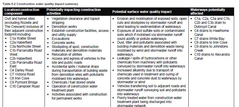
89 Appendix Q page106 Appendix Q page 176


90 Table D1 page D-1 Chapter 20: Non Aboriginal Heritage
M4-M5 Link Rozelle Interchange factsheet 2017
 M4-M5 Link Rozelle Interchange factsheet 017 WestConnex is part of the ustralian and NSW governments vision for supporting Sydney s growing population and keeping our economy strong. The M4-M5 Link is
(blank page) WestConnex New M Roads and Maritime Services Environmental impact statement
 WestConnex New M Roads and Maritime Services Environmental impact statement") (blank page) WestConnex New M5 5-42 (blank page) WestConnex New M5 5-44 5.5 Tunnels 5.5.1 Main alignment tunnels The main alignment tunnels would be about nine kilometres long, with the western tunnel
(blank page) WestConnex New M5 5-42 (blank page) WestConnex New M5 5-44 5.5 Tunnels 5.5.1 Main alignment tunnels The main alignment tunnels would be about nine kilometres long, with the western tunnel
Review of Environmental Factors Addendum. Green Square Stormwater Drain Shea s Creek Channel Corridor Restoration
 Review of Environmental Factors Addendum Green Square Stormwater Drain Shea s Creek Channel Corridor Restoration November 2016 Sydney Water Corporation (2014). Commercial in Confidence. All rights reserved.
I539. Smales 2 Precinct
 I539. Smales 2 Precinct I539.1. Precinct Description The Smales 2 Precinct applies to a 4.8 hectare block of land located on the southern side of Northcote Road and fronting Lake Pupuke, Takapuna. The
CHATSWOOD TO SYDENHAM. Project Update NORTHERN SURFACE TRACK WORKS - CHANGES IN CONSTRUCTION METHODOLOGY
 CHATSWOOD TO SYDENHAM Project Update NORTHERN SURFACE TRACK WORKS - CHANGES IN CONSTRUCTION METHODOLOGY AUGUST 2016 1 rthern surface track works changes in construction methodology 1.1 Introduction Section
CITY OF SYDNEY SUBMISSION ON WESTCONNEX STAGE 3 M4-M5 LINK CONCEPT DESIGN (RELEASED MAY 2017)
") CITY OF SYDNEY SUBMISSION ON WESTCONNEX STAGE 3 M4-M5 LINK CONCEPT DESIGN (RELEASED MAY 2017) EXECUTIVE SUMMARY The City of Sydney strongly objects to and opposes WestConnex. This expensive toll road project
CITY OF SYDNEY SUBMISSION ON WESTCONNEX STAGE 3 M4-M5 LINK CONCEPT DESIGN (RELEASED MAY 2017) EXECUTIVE SUMMARY The City of Sydney strongly objects to and opposes WestConnex. This expensive toll road project
17A. Wind Microclimate
 17A. Wind Microclimate 17A.1 Introduction 17A.1.1 17A.1.2 17A.1.3 17A.1.4 This Chapter, which has been prepared by Waterman and BMT, provides further information with regard to the potential wind microclimate
Chapter 9 Route window W18 Slough station. Transport for London
 Chapter 9 Route window W18 Slough station Transport SLOUGH STATION 9 Route window W18 Slough station 9.6 Wexham Road bridge worksite north; and Wexham Road bridge worksite south. Uxbridge Road bridge
Chapter 4. Route Window C12: Mile End Park and Eleanor Street Shafts
 Chapter 4 Route Window C12: Mile End Park and Eleanor Street Shafts 48 Crossrail Amendment of Provisions 4 Route Window C12: Mile End Park and Eleanor Street Shafts Location plan of Mile End Park and Eleanor
Chapter 10. Route Window C5: Tottenham Court Road East
 Chapter 10 Route Window C5: Tottenham Court Road East 112 Crossrail 10 Route Window C5: Tottenham Court Road East 10.1 Summary of Residual Impacts 10.1.1 The following significant residual adverse impacts
ROCKEFELLER UNIVERSITY
 ROCKEFELLER UNIVERSITY NEW RIVER BUILDING AND FITNESS CENTER Draft Environmental Impact Statement CEQR No. : 14DCP019M Lead Agency: New York City Department of City Planning Prepared By: AKRF, Inc. November
112th Avenue Light Rail Options Concept Design Report JUNE 2010 PREPARED FOR PREPARED BY TBG PGH
 112th Avenue Light Rail Options Concept Design Report JUNE 2010 PREPARED FOR PREPARED BY TBG060310124909PGH C ontents Introduction 1 Project Overview 1 Public Involvement and Technical Coordination 4 Description
Stage 2: WestConnex M5 King Georges Road Interchange Upgrade. Appendix B5 Construction Heritage Management Plan
 Stage 2: WestConnex M5 King Georges Road Interchange Upgrade Appendix B5 Construction Heritage Management Plan JULY 2016 DOCUMENT CONTROL File name Report name CEMP App B5 CHMP Rev E Revision number E
13 Land use and property
 13 Land use and property This chapter assesses land use and property impacts associated with the project. The assessment includes: Identification of the local land uses, existing access arrangements and
Strategic Environmental Assessment Screening Report. Dublin Port Masterplan Review 2017
 Strategic Environmental Assessment Screening Report Dublin Port Masterplan Review 2017 Table of Contents 1 Introduction... 1 2 Purpose of the Masterplan... 2 3 Task 1.1 Pre-Screening Check... 5 4 Task
West Gate Tunnel Project. Incorporated Document May Incorporated document pursuant to section 6(2)(j) of the Planning and Environment Act 1987.
(j) of the Planning and Environment Act 1987.") West Gate Tunnel Project Incorporated Document May 2017 Incorporated document pursuant to section 6(2)(j) of the Planning and Environment Act 1987. Drafting Note: The planning control contained in this
West Gate Tunnel Project Incorporated Document May 2017 Incorporated document pursuant to section 6(2)(j) of the Planning and Environment Act 1987. Drafting Note: The planning control contained in this
I615. Westgate Precinct
 I615. Westgate Precinct I615.1. Precinct Description The Westgate Precinct is located approximately 18km west of the Auckland city centre. There are seven Sub-precincts in the Westgate Precinct: Sub-precinct
6 BRIDGES. 6.1 Design philosophy. Proposed bridges
 SECTION 6 BRIDGES 6 BRIDGES Throughout the Project, bridges are a key visual element and marker for road users, pedestrians and cyclists. The design of bridges, as with other visible structures, has been
City of Cornwall Municipal Class Environmental Assessment. Proposed Improvement and Extension of Lemay Street
 Welcome City of Cornwall Municipal Class Environmental Assessment Proposed Improvement and Extension of Lemay Street Redevelopment and Design of the Municipal Works Yard Public Information Centre #1 Thursday,
SPECIAL 35 (HIBISCUS COAST GATEWAY) ZONE
 ZONE") `` 12.8.35 SPECIAL 35 (HIBISCUS COAST GATEWAY) ZONE 12.8.35.1 Issues The following provisions relate to the Hibiscus Coast Gateway Zone. This zone is located at Silverdale in the area bounded by State
`` 12.8.35 SPECIAL 35 (HIBISCUS COAST GATEWAY) ZONE 12.8.35.1 Issues The following provisions relate to the Hibiscus Coast Gateway Zone. This zone is located at Silverdale in the area bounded by State
RE: AMENDMENT C375 GEELONG PLANNING SCHEME 1900 BARWON HEADS ROAD, BARWON HEADS
 Reference: #V157080 14 August 2018 Barwon Heads Lifestyle Group Pty Ltd C/- Best Hooper Lawyers Level 9, 451 Little Bourke Street MELBOURNE VIC 3000 Attention: Mr. Edward Mahony (Lawyer) Dear Edward RE:
Welcome to the Public Consultation Exhibition
 Welcome to the Public Consultation Exhibition Today is your opportunity to: Speak to the team Learn more about the project Leave feedback on the plans The Secretary of State for Transport has recognised
Grantham Southern Quadrant Link Road Environmental Statement
 Grantham Southern Quadrant Link Road Environmental Statement Non Technical Summary Introduction Lincolnshire County Council (LCC) is submitting a planning application for the proposed implementation of
Eastern City District Plan
 OUR GREATER SYDNEY 2056 Revised Draft Eastern City District Plan OVERVIEW Bayside Burwood Canada Bay City of Sydney Inner West Randwick Strathfield Waverley Woollahra Snapshot of the Eastern City District
OUR GREATER SYDNEY A metropolis of three cities. OVERVIEW. connecting people. DRAFT Greater Sydney Region Plan
 OUR GREATER SYDNEY 2056. A metropolis of three cities. OVERVIEW. connecting people. DRAFT Greater Sydney Region Plan October 2017 This document is an overview of the draft Greater Sydney Region Plan. To
Right-of-Way Acquisitions and Relocations Technical Memorandum
 Right-of-Way Acquisitions and Relocations Technical Memorandum Southeast Extension Project Lincoln Station to RidgeGate Parkway Prepared for: Federal Transit Administration Prepared by: Denver Regional
Chapter 27 Route Window SE7 Church Manorway Bridge. Transport for London
 Chapter 27 Route Window SE7 Church Manorway Bridge Transport for London CHURCH MANORWAY BRIDGE 27 Route Window SE7 Church Manorway bridge Introduction 27.1 The North Kent Line will be converted to four
North Somerset Council Local Development Framework
 North Somerset Council Local Development Framework Sites and Policies Development Plan Document Evidence Paper Re-opening Portishead Railway Line and Options for the Location of Portishead Railway Station
PUBLIC HEARING. Thursday, December 14, 2017 FDOT Urban Office 2198 Edison Avenue Jacksonville, FL 32204
 DISTRICT TWO PUBLIC HEARING I 10 (SR 8) from I 295 to I 95 Project Development & Environment Study Duval County, Florida Financial Project Number 213326 2 22 01 Efficient Transportation Decision Making
WestConnex. Building for the Future: M4 East (Stage 1) Community Feedback Report. April 2014 ISBN:
 Community Feedback Report. April 2014 ISBN:") WestConnex Building for the Future: M4 East (Stage 1) Community Feedback Report April 2014 ISBN: 978-1-925093-38-4 Contents Executive summary... 4 1. Introduction and background... 6 1.1 Purpose of this
WestConnex Building for the Future: M4 East (Stage 1) Community Feedback Report April 2014 ISBN: 978-1-925093-38-4 Contents Executive summary... 4 1. Introduction and background... 6 1.1 Purpose of this
Subdivision Design Criteria. Penihana North GUIDELINES TO THE RULES
 Created September 2013 Penihana North Subdivision Design Criteria GUIDELINES TO THE RULES This part of the Plan sets out the design criteria for subdivision in Penihana North. The criteria will be considered
SH20 Manukau Harbour Crossing Project Notice of Requirement Auckland City Council
 19 May 2006 (Updated 28 August 2006) Notice of Requirement Dated 19 May 2006: Updated 28 August 2006 Notice of Requirement Dated 19 May 2006: Updated 28 August 2006 Page i Form 18 Notice of Requirement
4.0 AFFECTED ENVIRONMENT AND ENVIRONMENTAL CONSEQUENCES
 4.0 AFFECTED ENVIRONMENT AND ENVIRONMENTAL CONSEQUENCES The following sections discuss the impacts associated with environmental resources for the tunneling method Alternatives A and B. The construction
NEWSLETTER #03 BEAUDESERT ROAD LOGAN MOTORWAY
 NEWSLETTER #03 MT. LINDESAY HIGHWAY Feedback shapes design changes Thank you to the more than 600 stakeholders and community members that provided feedback on the Logan Enhancement Project initial concept
Chapter 1 - General Design Guidelines CHAPTER 1 GENERAL DESIGN GUIDELINES
 CHAPTER 1 GENERAL DESIGN GUIDELINES 1.0 INTRODUCTION This Publication has been developed to provide current, uniform procedures and guidelines for the application and design of safe, convenient, efficient
DRAFT GREATER SYDNEY REGION PLAN OBJECTIVES, STRATEGIES AND ACTIONS
 Greater Sydney Commission DRAFT GREATER SYDNEY REGION PLAN OBJECTIVES, STRATEGIES AND ACTIONS Issued: 26 OCTOBER 2017 Version: 1 Subject: Greater Sydney Region and District Plans This information note
Chapter 7 Route window W20 Dover Road and Leigh Road bridges. Transport for London
 Chapter 7 Route window W20 Dover Road and Leigh Road bridges Transport for London ROUTE WINDOW W20 7 Route window W20 Dover Road and Leigh Road bridges Transport for London 7.6 7.7 7.8 Baseline conditions
Chapter 10 Route window W17 Middlegreen Road, St Mary s Road and Trenches bridges. Transport for London
 Chapter 10 Route window W17 Middlegreen Road, St Mary s Road and Trenches bridges Transport for London MIDDLEGREEN ROAD, ST MARY S ROAD AND TRENCHES BRIDGES 10 Route window W17 Middlegreen Road, St Mary
Plumstead Temporary Railway Sidings and Associated Permanent Works
 Plumstead Temporary Railway Sidings and Associated Permanent Works Environmental Impact Assessment Non-Technical Summary Document Number: February 2013 Plan Design Enable Page 2 of 20 Contents Contents...
East River Waterfront Esplanade and Piers New York, New York Draft Environmental Impact Statement
 East River Waterfront Esplanade and Piers New York, New York Draft Environmental Impact Statement October 12, 2006 CEQR No.: TO COME ULURP Nos.: TO COME Lead Agency: Lower Manhattan Development Corporation
Longbridge Town Centre Phase 2 Planning Application
 Longbridge Town Centre Phase 2 Planning Application Non-Technical Summary of the Environmental Statement December 2013 Introduction A full application for Planning Permission has been submitted to Birmingham
Start of works exhibition
 Start of works exhibition Find out about the work that Highways England are undertaking to create a new interchange junction 700 metres east of junction 10 over the M20, a dual carriageway link road to
LONDON BRIDGE STATION ENVIRONMENTAL STATEMENT NON-TECHNICAL SUMMARY
 LONDON BRIDGE STATION ENVIRONMENTAL STATEMENT NON-TECHNICAL SUMMARY June 2011 1 EXECUTIVE SUMMARY 2 INTRODUCTION CONTENTS Page 2.1 Introduction 4 2.2 The Site 4 3 THE DEVELOPMENT 3.1 What is it? 5 3.2
Draft Eastern District Plan
 Draft Eastern District Plan Submission_id: 31238 Date of Lodgment: 13 Dec 2017 Origin of Submission: Online Organisation name: Turrulla Gardens Pty Ltd C/- Mecone Organisation type: Industry First name:
4.1 Build Alternative 1 Construction Phasing
 SECTION 4 Implementation Plan This section discusses potential segmentation of the build alternatives into multiple projects for implementation of improvements to the NSH from Rabbit Creek Road to 36th
FANSHAWE PARK ROAD/RICHMOND STREET INTERSECTION IMPROVEMENTS. PUBLIC INFORMATION CENTRE 2 June 16, 2016
 FANSHAWE PARK ROAD/RICHMOND STREET INTERSECTION IMPROVEMENTS Municipal Class Environmental Assessment PUBLIC INFORMATION CENTRE 2 June 16, 2016 ACCESSIBILITY Under the Accessibility Standards 2015 for
NEWCASTLE LIGHT RAIL Review of Environmental Factors (REF) Submission 20 May 2016
 Submission 20 May 2016") NEWCASTLE LIGHT RAIL Review of Environmental Factors (REF) Submission 20 May 2016 INTRODUCTION The Hunter Business Chamber is the largest regional business chamber in Australia and was established in 1886.
NEWCASTLE LIGHT RAIL Review of Environmental Factors (REF) Submission 20 May 2016 INTRODUCTION The Hunter Business Chamber is the largest regional business chamber in Australia and was established in 1886.
NORTH-SOUTH CORRIDOR STUDY EXECUTIVE SUMMARY. Executive Summary
 Executive Summary Background As congestion continues to affect mobility in the region, the Ozarks Transportation Organization (OTO) is particularly concerned with traffic movement. The North-South Corridor
7. The Landscape. 7.1 Introduction. Environmental Impact Statement (EIS) Scoping Report
 Scoping Report") 7. The Landscape 7.1 Introduction The purpose of this section of the EIS Scoping Report is to describe the scope of work and methods to be applied in the identification and assessment of landscape and
7. The Landscape 7.1 Introduction The purpose of this section of the EIS Scoping Report is to describe the scope of work and methods to be applied in the identification and assessment of landscape and
PROPOSED IMPROVEMENTS
 IV. PROPOSED IMPROVEMENTS The proposed improvements for each alternative carried forward are discussed below. A. FUNCTIONAL CLASSIFICATION AND ROADWAY CROSS-SECTIONS The classifications of the roadways
I. DESCRIPTION OF PROPOSED ACTION... 1 A. General Description... 1 B. Historical Resume and Project Status... 2 C. Cost Estimates...
 PROJECT COMMITMENTS SUMMARY... S-1 1. Type of Action... S-1 2. Description of Action... S-1 3. Summary of Purpose and Need... S-1 4. Alternatives Considered... S-2 5. NCDOT Alternatives Carried Forward...
Services Department F May 28, 2007
 Report To: Development Services Committee Item: Date of Report: From: DS-07-144 May 23, 2007 Commissioner, Development File: Date of Meeting: Services Department F-7000-0013 May 28, 2007 Subject: Gibb
COUNCIL ATTACHMENT 2 HIGHWAY 7 CORRIDOR AND VAUGHAN NORTH-SOUTH LINK
 COUNCIL ATTACHMENT 2 HIGHWAY 7 CORRIDOR AND VAUGHAN NORTH-SOUTH LINK Welcome! The purpose today is to: Present the Study Background; Describe Alignment Alternatives Analyzed; Present the Evaluation of
Planning Proposal Toronto Road, Booragul. Amendment to Lake Macquarie Local Environmental Plan (LMLEP) 2014
 2014") Planning Proposal Toronto Road, Booragul Amendment to Lake Macquarie Local Environmental Plan (LMLEP) 2014 Local Government Area: Name of Draft LEP: Subject Land: Land Owner: Applicant: Folder Number:
Planning Proposal Toronto Road, Booragul Amendment to Lake Macquarie Local Environmental Plan (LMLEP) 2014 Local Government Area: Name of Draft LEP: Subject Land: Land Owner: Applicant: Folder Number:
Northern Branch Corridor SDEIS March Table of Contents
 Table of Contents Executive Summary... ES-1 ES.1 Introduction... ES-1 ES.2 Project Background... ES-1 ES.3 Purpose and Need... ES-5 ES.4 Alternatives... ES-6 ES.5 Operating Plan... ES-11 ES.6 Cost Analysis...
15.0 EFFECT ON THE ENVIRONMENT: Sunlight
 15.0 EFFECT ON THE ENVIRONMENT: Sunlight 15.1 Introduction 15.1.1 ARC Architectural Consultants Ltd has been retained to carry out an analysis of the shadows likely to be cast by the proposed structures
Environmental Statement AP2 33
 Environmental Statement AP2 33 3.10.5 The Barbican is a largely residential estate located within the City of London and includes a number of communal and public buildings including the Arts Centre, St.
Victor Shapilsky and Adison Ang
 Victor Shapilsky and Adison Ang Incident Detection Systems in Motorway Tunnels Overview Incidents Delayed incident detection Performance criteria for incident detection systems Available incident detection
I-66 EASTBOUND WIDENING INSIDE THE BELTWAY PARDON OUR DUST MEETING
 I-66 EASTBOUND WIDENING INSIDE THE BELTWAY From the Dulles Connector Road (Route 267) to Fairfax Drive (Route 237) PARDON OUR DUST MEETING Bill Cuttler, PE (VDOT District Construction Engineer, Northern
Visual and Aesthetic Resources
 Visual and Aesthetic Resources 7.1 INTRODUCTION This chapter evaluates the effects of the Modified Design on visual and aesthetic resources, in comparison to the effects of 2004 FEIS Design. The 2004 FEIS
ROAD CLOSURE AND LAND USE AMENDMENT SILVER SPRINGS (WARD 1) NORTHEAST OF NOSEHILL DRIVE NW AND SILVER SPRINGS ROAD NW BYLAWS 2C2018 AND 29D2018
 NORTHEAST OF NOSEHILL DRIVE NW AND SILVER SPRINGS ROAD NW BYLAWS 2C2018 AND 29D2018") Page 1 of 19 EXECUTIVE SUMMARY This application proposes redesignating two parcels in the community of Silver Springs from Special Purpose Future Urban Development (S-FUD) District and undesignated road
Page 1 of 19 EXECUTIVE SUMMARY This application proposes redesignating two parcels in the community of Silver Springs from Special Purpose Future Urban Development (S-FUD) District and undesignated road
Land Use Amendment in Southwood (Ward 11) at and Elbow Drive SW, LOC
 at and Elbow Drive SW, LOC") 2018 November 15 Page 1 of 10 EXECUTIVE SUMMARY This land use amendment application was submitted by Rick Balbi Architect on 2017 August 31 on behalf of Sable Developments Ltd, and with authorization from
2018 November 15 Page 1 of 10 EXECUTIVE SUMMARY This land use amendment application was submitted by Rick Balbi Architect on 2017 August 31 on behalf of Sable Developments Ltd, and with authorization from
Equity and Environmental Justice B. MINORITY, ELDERLY, AND LOW INCOME POPULATIONS IN THE STUDY AREA
 Chapter 16: Equity and Environmental Justice A. INTRODUCTION The proposed project alternatives would traverse a large study area that contains a wide range of neighborhoods, residents, and workers. The
South District Plan OVERVIEW
 OUR GREATER SYDNEY 2056 Revised Draft South District Plan OVERVIEW Canterbury-Bankstown Georges River Sutherland Snapshot of the South District today and into the future The Greater Sydney Commission acknowledges
Mavis Road Class Environmental Assessment
 Mavis Road Class Environmental Assessment Public Information Centre #2 Wednesday November 9, 2016 6:00 to 8:00 p.m. Please sign in and complete a comment sheet Review the displays on your own or join in
Planning Proposal Concurrent DA/LEP Amendment for Belmont North Pharmacy Amendment No. 24 to Lake Macquarie Local Environmental Plan (LMLEP) 2014
 2014") Planning Proposal Concurrent DA/LEP Amendment for Belmont North Pharmacy Amendment No. 24 to Lake Macquarie Local Environmental Plan (LMLEP) 2014 Local Government Area: Name of Draft LEP: Subject Land:
Planning Proposal Concurrent DA/LEP Amendment for Belmont North Pharmacy Amendment No. 24 to Lake Macquarie Local Environmental Plan (LMLEP) 2014 Local Government Area: Name of Draft LEP: Subject Land:
5.7.6 St Peters Interchange Portal
 5.7.6 St Peters Interchange Portal Design intent At St Peters interchange the design approach to the tunnel portals differs from that adopted for the western portals at Kingsgrove. An entirely different
HS2 Interchange Station Design
 Working on behalf of HS2 Interchange Station Design October 2018 www.hs2.org.uk 1 Interchange Station, Solihull Introduction In February 2018, HS2 Ltd appointed Arup to take forward the design of Interchange
Road transport activities and infrastructure can have adverse effects on the environment and community.
 22 Road Transport 22.1 Significant Issues Road transport activities and infrastructure can have adverse effects on the environment and community. Land use activities can have adverse effects on the safety
4.11 TRAFFIC Existing Conditions Existing Project Site. Existing Street System
 4.11 TRAFFIC This traffic and circulation section is based on a Traffic Impact Study conducted by Linscott Law & Greenspan Engineers, which is provided in full in Appendix F. This traffic analysis has
Carleton University. Nicol Building New Sprott School of Business. Design Brief and Planning Rationale. Carleton University
 Carleton University Nicol Building New Sprott School of Business Design Brief and Planning Rationale Carleton University Design Team Proposal New Sprott School of Business Academic Building 2019 October
Board Order 29S.PA0049
 Board Order 29S.PA0049 Planning and Development Acts, 2000 to 2017 Planning Authority: Dublin City Council Application for permission under section 37E of the Planning and Development Act 2000, as amended,
Amendment C146 Melton Planning Scheme Expert Evidence Statement Traffic & Transport Beattys Road, Plumpton
 235 311 Beattys Road, Plumpton 16585REP001C-F 21 November 2016 onemilegrid.com.au 1/59 Keele Street, Collingwood, VIC 3066 (03) 9939 8250 onemilegrid ABN: 79 168 115 679 (03) 9939 8250 1/59 Keele Street
BREEDON NORTHERN LIMITED
 Non Technical Summary CONTENTS 1 INTRODUCTION... 1 2 SITE DESCRIPTION... 1 3 DESCRIPTION OF THE DEVELOPMENT... 6 4 NEED FOR THE DEVELOPMENT... 8 5 KEY ISSUES CONSIDERED IN THE ENVIRONMENTAL IMPACT ASSESSMENT...
BRIDGECLIMB SYDNEY REDUCING TONAL NOISE FROM SAFETY LATCHES
 BRIDGECLIMB SYDNEY REDUCING TONAL NOISE FROM SAFETY LATCHES Conrad M. Weber Heggies Australia Pty Ltd, Sydney, Australia Abstract Each year, thousands of Sydneysiders and visitors climb Sydney s most prominent
EVALUATION OF MASTER PLAN ALTERNATIVES
 7 The Environmental Report is required to identify, describe and evaluate reasonable alternatives, taking into account the objectives and geographical scope of the Master Plan 2008. Three plan alternatives
Proposed World-Class Hotel at Former Royal High School, Regent Road, Edinburgh
 Duddingston House Properties and Urbanist Hotels Proposed World-Class Hotel at Former Royal High School, Regent Road, Edinburgh Environmental Statement Non-Technical Summary 3rd September 2015 www.oldroyalhighschool.com
REVIEW OF ENVIRONMENTAL FACTORS
 REVIEW OF ENVIRONMENTAL FACTORS GLENWOOD PEDESTRIAN LINK April 2018 sydneymetro.info 1800 171 386 sydneymetro@transport.nsw.gov.au Version: Date: Description: 01 29 February 2018 First draft REF for Transport
I207. Learning Precinct
 I207. Learning Precinct I207.1. Precinct description The Learning Precinct is centred on the Symonds Street ridge where the University of Auckland and Auckland University of Technology have the majority
WELLINGTON HOSPITAL DESIGN GUIDE TABLE OF CONTENTS
 WELLINGTON HOSPITAL DESIGN GUIDE TABLE OF CONTENTS 1.0 Introduction Page 2 The Place of Wellington Hospital 2 The Future of the Hospital 2 2.0 The Intention of the Design Guide 3 3.0 Analysis 4 General
FORMER CANADIAN FORCES BASE (CFB) ROCKCLIFFE SECONDARY PLAN. Official Plan Amendment XX to the Official Plan for the City of Ottawa
 ROCKCLIFFE SECONDARY PLAN. Official Plan Amendment XX to the Official Plan for the City of Ottawa") FORMER CANADIAN FORCES BASE (CFB) ROCKCLIFFE SECONDARY PLAN Official Plan Amendment XX to the Official Plan for the City of Ottawa 1 INDEX THE STATEMENT OF COMPONENTS PART A THE PREAMBLE PAGE Purpose...
FORMER CANADIAN FORCES BASE (CFB) ROCKCLIFFE SECONDARY PLAN Official Plan Amendment XX to the Official Plan for the City of Ottawa 1 INDEX THE STATEMENT OF COMPONENTS PART A THE PREAMBLE PAGE Purpose...
APPENDIX D: Visual and Aesthetic Conditions for NCCU Station Refinement. Durham-Orange Light Rail Transit Project
 APPENDIX D: Visual and Aesthetic Conditions for NCCU Station Refinement Durham-Orange Light Rail Transit Project October 2016 1. Introduction The Combined FEIS/ROD summarizes the effects of the D-O LRT
WestConnex. New M5 State Significant Infrastructure Application Report. November 2014 ISBN:
 WestConnex New M5 State Significant Infrastructure Application Report November 2014 ISBN: 978-1-925217-04-9 (blank page) The New M5 November 2014 Prepared for Prepared by AECOM Australia Pty Ltd Level
Chapter 2: OUTLINE PLANNING APPLICATION PROPOSALS. A New Garden Neighbourhood Matford Barton 17
 Chapter 2: OUTLINE PLANNING APPLICATION PROPOSALS A New Garden Neighbourhood Matford Barton 17 2.1. SUMMARY AND STATUS OF THE PROPOSALS 2.1.1. The parameter plans and associated wording in this chapter
Planning Proposal Charlestown Swim and Leisure Centre LEP Amendment
 Planning Proposal Charlestown Swim and Leisure Centre LEP Amendment Amendment No. 4 to Lake Macquarie Local Environmental Plan 2014 (PP_2014_LAKEM_005_00) Local Government Area: Name of Draft LEP: Lake
Public Information Centre #1
 and Highway 401 Interchange Improvements WELCOME Public Information Centre #1 Veterans Memorial Parkway Extension and Highway 401 Interchange Improvements Study May 23, 2012 4 p.m. to 7 p.m. Brief Overview
Chapter 22. Alternatives to the Proposed Project
 Page 22-1 Chapter 22. Alternatives to the Proposed Project Introduction This chapter assesses the potential environmental effects of alternatives to the Proposed Project. The alternatives analyzed include
Volume 2: Assessment of Environmental Effects 438
 Volume 2: Assessment of Environmental Effects 438 28 Social Effects Overview The purpose of this Chapter is to provide a summary of the assessment of the social effects of the Project. The assessment has
South District What we heard
 What we heard Vision to 2056 and Priorities Governance and implementation Infrastructure and funding Feedback supported: The vision for a metropolis of three cities, but emphasised the importance of infrastructure
4 RESIDENTIAL ZONE. 4.1 Background
 4 RESIDENTIAL ZONE 4.1 Background The residential areas within the City are characterised by mainly lowrise dwellings sited on individual allotments. Past architectural styles, settlement patterns and
2.0 PURPOSE AND NEED. 2.1 Purpose. 2.2 Need Traffic Congestion in and around Downtown Derry
 2.0 PURPOSE AND NEED Taking into consideration agency and public input, the purpose and need for the Project was identified early in Project planning. As noted in Appendix A, for purposes of meeting the
TOWN OF WHITBY REPORT RECOMMENDATION REPORT
 TOWN OF WHITBY REPORT RECOMMENDATION REPORT REPORT TO: Council REPORT NO: PL 95-09 DATE OF MEETING: October 13, 2009 PREPARED BY: Planning/Public Works Joint Report FILE NO(S): N/A LOCATION: N/A REPORT
Request for Decision. Recommendation. Presented: Monday, Jul 07, Report Date Friday, Jun 20, Type: Public Hearings
 Presented To: Planning Committee Request for Decision Application for rezoning in order to permit a place of worship on a vacant lot zoned for C1, Local Commercial uses, Cam Street, Sudbury Sitiri Investments
4 Residential and Urban Living Zones
 4 Residential and Urban Living Zones Refer to Chapters 11 to 20 for additional rules that may apply to these zones. 4.1 OBJECTIVES AND POLICIES Objective Res1 Policy 1 Policy 2 Policy 3 Policy 4 Policy
Child Minding Centres and Family Day Care
 Child Minding Centres and Family Day Care Policy Type: Local Planning Policy Policy Owner: Director Urban Planning Policy No. LPP1.12 Last Review Date: 20 September 2016 Policy Objectives To provide for
Statement of Community Involvement LAND OFF SOUTHDOWN ROAD HORNDEAN, HAMPSHIRE
 LAND OFF SOUTHDOWN ROAD HORNDEAN, HAMPSHIRE CONTENTS Page 1. Introduction 3 2. Pre-application Discussions 4 3. The Consultation Process 5 4. Consultation Feedback 7 5. Responses to Consultation Feedback
AOTEA SUPERMARKET ZONE. Zone Introduction
 C18 AOTEA SUPERMARKET ZONE Zone Introduction C18.1 Objective This zone identifies a specific area in Aotea for a stand alone supermarket. The zone is site specific and has a range of objectives, policies
WATERLOO STATE SIGNIFICANT PRECINCT SUMMARY OF STUDIES
 WATERLOO STATE SIGNIFICANT PRECINCT SUMMARY OF STUDIES Technical studies will be undertaken to inform the master planning process for the Waterloo precinct to develop a Precinct Proposal to redevelop the
M7 Naas to Newbridge Bypass Upgrade Scheme. Landscape and Visual Impact Assessment Brief of Evidence
 M7 Naas to Newbridge Bypass Upgrade Scheme Landscape and Visual Impact Assessment Brief of Evidence Presented by Richard Butler, Cunnane Stratton Reynolds Landscape Architect: BL Arch (University of Pretoria,
Welcome to our exhibition
 Welcome to our exhibition The Homes & Communities Agency (HCA) welcomes you to this public exhibition explaining our proposals for the redevelopment of the former Lea Castle Hospital site. About the Homes