13 Land use and property
|
|
|
- Adele Haynes
- 5 years ago
- Views:
Transcription
1 13 Land use and property This chapter assesses land use and property impacts associated with the project. The assessment includes: Identification of the local land uses, existing access arrangements and potential property acquisition for both public and private land affected by the project Assessment of the potential impacts of the project on property, land use and access arrangements during and operation of the project Identification of appropriate management and safeguard measures to minimise these impacts. Table 13-1 sets out the Secretary s Environmental Assessment Requirements (SEARs) as they relate to land use and property, and where in the environmental impact statement (EIS) these have been addressed. Table 13-1 SEARs land use and property Secretary s Environmental Assessment Requirement Land use changes as a result of the proposal and the acquisition of privately owned, Council and Crown lands, and impacts to Council and Crown lands, An analysis of the proposal including an assessment, with a particular focus on the requirements of the listed key issues, in accordance with clause 7(1)(d) of Schedule 2 of the Regulation (where relevant), including an identification of how relevant planning, land use and development matters (including relevant strategic and statutory matters) have been considered in the impact assessment (direct, indirect and cumulative impacts) and/or in developing mitigation measures (to avoid, manage, offset and monitor impacts and where relevant, improve the existing environment)... Where addressed Land use changes as a result of the proposal and the acquisition of privately owned, council and Crown lands, and impacts to council and Crown lands are detailed in Section An assessment of the project s potential impacts on land use and property is included in Section 13.3 and mitigation measures are presented in Section A full description of the project is provided in Chapter 5 (Project description). Chapter 6 (Construction work) identifies the land to be used for the project. A list of approvals for the project is provided in Chapter 2 (Assessment process). Indirect impacts are considered to be mainly social and economic related and therefore covered in Chapter 15 (Social and economic). Chapter 27 (Cumulative) provides the cumulative impact assessment. The EIS must also address the following specific matters: impacts on directly affected properties and land uses, including impacts related to access, land use, settlement and subsidence associated with tunnel excavation, property acquisition (including relocations and expenses for those properties acquired) and amenity related changes; Chapter 30 provides a summary of the environmental management and mitigation measures for the project. Potential impacts of the project on property access, land use, settlement and subsidence associated with tunnel excavation, property acquisition are discussed in Section Amenity related changes are addressed in Chapter 14 (Visual impacts and urban design). WestConnex New M5 13-1
2 Secretary s Environmental Assessment Requirement opportunities for local centre and street revitalisation near the St Peters interchange; an assessment of the impact of the proposal on community facilities, including open space and recreational facilities. The assessment must include the use of existing facilities impacted by the proposal, and options and opportunities for the relocation and/or reconfiguration of the community facilities, both temporary and permanent; where there are potential impacts to the OEH estate reserved under the National Parks and Wildlife Act 1974 or where the proposal is located upstream of OEH estate, an assessment of the matters to be considered outlined in the Guidelines for developments adjoining land and water managed by Department of Environment, Climate Change and Water (DECCW 2010); potential impacts on utilities (including communications, electricity, gas, and water and sewerage) and the relocation of these utilities 13.1 Assessment methodology Where addressed Opportunities for local centre and street revitalisation are provided in the Urban Design Report (Appendix L). Impacts of the proposal on community facilities is describes in Section 13.3 and Chapter 15 (Social and economic) The project would not directly impact any OEH estate reserved under the National Parks and Wildlife Act Impacts of the project on land use and property during and operation are described in Section and Section Potential impacts of the project on utilities are described in Section The assessment of impacts from the project on property and land use included: Providing an overview of the existing character, land use and zoning in the vicinity of the project components Reviewing the zoning and minimum lot size provisions of the relevant local environment plans Identifying the properties and land uses that would be impacted by the project Assessing the potential for land used for of the project, but not proposed to include permanent operational infrastructure (surplus or residual land) to be redeveloped following Identifying potential impacts of the project on future development within the project area Compiling mitigation measures that would assist in reducing impacts on land use and property Existing environment The existing environment for land use and property has been described in terms of the broader, regional environment of the project corridor within Sydney, as well as the local environment relevant to each of the specific elements of the project Regional context The project corridor spans the Hurstville, Canterbury, Rockdale, Marrickville, Botany Bay and City of Sydney local government areas (LGAs). Land use and existing development within and around the project corridor is urban (eastern end of the project corridor) and suburban (western end of the project corridor) in nature, containing a mix of residential, commercial, industrial and open space uses. There are several major transport corridors and other infrastructure located in or adjacent to the project corridor, including the M5 East Motorway, the Princes Highway, the Sydney Trains suburban railway network and the Sydney Airport. WestConnex New M5 13-2
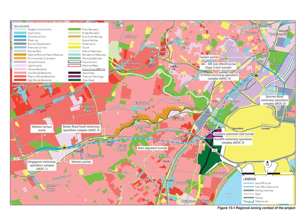
3 Land uses within the project corridor include a mix of: Residential land: Predominately low density residential, with medium and high density residential land uses in areas close to public transport, along arterial roads and at the eastern extent of the project corridor. Land use changes are occurring within the project corridor as older industrial areas are redeveloped for residential purposes. This includes the significant mixed use redevelopment at Wolli Creek within the Rockdale LGA Open space: Nature reserves, active recreational uses (such as golf courses and sports grounds) and passive recreational uses are located throughout the project corridor. This includes the Canterbury Golf Course, Beverly Grove Park, Wolli Creek Regional Park, Cahill Park, Barton Park, the Kogarah Golf Course, Tempe Recreation Reserve and Sydney Park. Continuous open space corridors, consisting of a series of smaller open spaces, are located along Bardwell Creek, Wolli Creek and the Cooks River Industrial and commercial land: Concentrated in the suburbs of Kingsgrove, Turrella, Wolli Creek, Arncliffe, Tempe, St Peters, Mascot and Alexandria. Commercial uses are typically concentrated along arterial roads (such as the Princes Highway) and at railway stations and, alongside medium and high density residential uses. Community facilities, churches, schools, medical and veterinary centres are located along the length of the project corridor. Land use zonings within the project corridor are set by the following environmental planning instruments: Sydney Regional Environmental Plan No. 33 Cooks Cove (Cooks Cove SREP) Hurstville Local Environmental Plan 2012 (Hurstville LEP) Canterbury Local Environmental Plan 2012 (Canterbury LEP) Rockdale Local Environmental Plan 2011 (Rockdale LEP) Botany Bay Local Environmental Plan 2013 (Botany Bay LEP) Marrickville Local Environmental Plan 2011 (Marrickville LEP) Sydney Local Environmental Plan 2012 (Sydney LEP). The regional land use zoning context of the project is shown Figure The land use zoning generally aligns with existing development types within the project corridor and includes: General and light industrial Business (commercial) zones, including centres, enterprise corridors along major road and business parks Residential zones, ranging from low to high density Mixed use zones (commercial and residential) Special infrastructure zones, which align with major transport infrastructure and corridors, as well as drainage, electricity infrastructure and educational establishments Recreational zones (private and public) Conservation and waterways zones, including national parks and nature reserves. Transitional areas where the land use zonings and current development types are not fully aligned include industrial areas in Wolli Creek, Sydenham, St Peters and Alexandria undergoing redevelopment and conversion to residential areas. WestConnex New M5 13-3
4 A number of strategic planning initiatives are also underway within and around the project corridor. These include: The Princes Highway Corridor Strategy (Rockdale City Council) The Cooks Cove Growth Centre, on land subject to Sydney Regional Environmental Plan No. 33 Cooks Cove (Cooks Cover SREP) The Mascot Station Town Centre Precinct (City of Botany Bay Council) Sydenham Green (Marrickville Council) The Sydney Gateway, a future part of the WestConnex program of works (Transport for NSW) Southern and northern extensions to the WestConnex program of works (Transport for NSW) The Sydney Metro projects (Transport for NSW) Zoned employment lands. The Princes Highway Corridor Strategy, an initiative of Rockdale City Council, was adopted by the Council in late The strategy focuses on revitalising the corridor within the Rockdale local government area for employment uses and growing the Arncliffe town centre. This strategy targets changes to the distribution of residential, mixed use and business zones, as well as increased development densities. The Cooks Cove Growth Centre is a 100 hectare precinct, which is bounded by the Cooks River and Muddy Creek, Marsh Street, West Botany Street and Bestic Street, and is subject to the Cooks Cover SREP. Historical master planning for the site identified an area for potential employment uses near Marsh Street with the remainder of the site to be set aside for conservation, open space and recreational purposes. Planning for the site is currently being managed by the Urban Growth Development Corporation. The Mascot Station Town Centre Precinct, an initiative of the City of Botany Bay Council, is centred on the Mascot railway station and is partially located within the project corridor. The area has been rezoned as part of the Botany Bay Local Environmental Plan 2013, allowing for the intensification of residential and commercial land uses. Sydenham Green is a local park in Sydenham, which is partially located within the project corridor. Sydenham Green is bounded by Unwins Bridge Road, George Street, Henry Street, Railway Road, Stewart Lane, Park Road, Rowe Lane, and Reilly Lane. Sydenham Green was created through the demolition of houses in the mid-1990s as a result of a Commonwealth Government property acquisition program associated with the building of the third runway at Sydney Airport, and management of aircraft noise. More recently, Marrickville Council has developed the Sydenham Green Master Plan (ASPECT Studios, 2013) and the Sydenham Green Draft Plan of Management (Marrickville Council, 2013) to provide the basis for a future upgrade of the park to improve its amenity. WestConnex New M5 13-4
5
6 (blank page) WestConnex New M5 13-6
7 Sydney Gateway, a future part of the WestConnex program of works, would link the WestConnex motorway projects to the Sydney Airport and Port Botany. The future Sydney Gateway would comprise a mix of existing roads, upgraded roads and new infrastructure. Consultation with Sydney Airport and other strategic landholders is underway to develop a detailed proposal for the connection of the WestConnex motorways from the St Peters interchange to the airport and port precinct. The NSW Government is currently considering potential Northern and Southern connections to the WestConnex program of works. The extensions, one north from the WestConnex M4 East project and the other south from the WestConnex New M5 project (the Southern extension), would create broader connections between the WestConnex motorways and the Sydney metropolitan road network. This may include a connection to Sydney s North Shore via a third harbour crossing, and a connection towards the F6 corridor in the south. Both potential extensions have been identified in the NSW Government s 2012 Long Term Transport Master Plan as vital to Sydney s infrastructure and would provide an uninterrupted motorway corridor from Sydney s south to the Anzac Bridge, the CBD at Darling Harbour and North Sydney. The Sydney Metro projects would connect and extend a separate railway line from the North West Rail Link under Sydney Harbour, through the CBD, through Sydenham and west to Bankstown, with capacity to run up to 30 trains per hour in each direction on the new line (Transport for NSW, 2014). Investigations are currently underway to develop the design and alignment for a series of projects to complete the Sydney Metro connection. Zoned employment lands within the project corridor include light industrial lands at Kingsgrove, mixed use and enterprise corridor land along the Princes Highway at Arncliffe and general industrial areas in St Peters and Alexandria Local context The project would comprise an underground road tunnel and would therefore avoid direct impacts to the majority of land uses and properties within the project corridor. Impacts to land use and property would mainly occur at locations where surface works are proposed. Consequently, the local context is described below in terms of the land use surrounding each of the following surface sites: The western surface works, including: The M5 East Motorway integration works during and operation The Kingsgrove North compound (C1), the Kingsgrove South compound (C2) and the Commercial Road compound (C3) during The Kingsgrove motorway operations complex (MOC1) during operation. The Kingsgrove Road surface works including installation of toll infrastructure on the M5 East Motorway. The Bexley Road surface works, including: The Bexley Road North compound (C4), the Bexley Road South compound (C5) and the Bexley Road East compound (C6) during The Bexley Road South motorway operations complex (MOC2) during operation. The Arncliffe surface works, including: The Arncliffe compound (C7) during The Arncliffe motorway operations complex (MOC3) during operation. The St Peters interchange and local road upgrade surface works, including: The St Peters interchange works during and operation WestConnex New M5 13-7
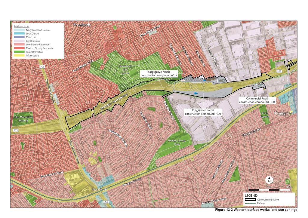
8 The Canal Road compound (C8), the Campbell Road compound (C9), the Landfill closure compound (C10), the Burrows Road compound (C11) and the Campbell Road bridge compound (C12), Gardeners Road bridge compound (C13) and Sydney Park compound (C14) The St Peters motorway operations complex (MOC4) and the Burrows Road motorway operations complex (MOC5) during operation Local road upgrade works during and operation. A full list of community facilities that were identified in proximity to the project are provided in the Technical working paper: Social and Economic (Appendix M) Western surface works The western surface works would be located in a corridor along the M5 East Motorway, between King Georges Road and Kingsgrove Road. Land use zonings and development controls in this area are regulated under: The Canterbury LEP to the north of the M5 East Motorway The Hurstville LEP to the south of the M5 East Motorway. The land use zonings within and around each the sites forming part of the western surface works are summarised in Table 13-2 and shown in Figure Existing land uses in the immediate vicinity of the western surface works include the M5 East Motorway corridor, the local and regional road network, residential lands and industrial lands. The East Hills, Airport and Inner West railway line passes in an east-west direction, about 300 metres to the south of the M5 East Motorway. Public recreation areas and infrastructure located around the western surface works include: A shared pedestrian and bicycle path within Beverley Grove Park, part of the M5 Linear Park, located on the northern and southern side of the M5 East Motorway corridor. This shared path would be directly affected by the Kingsgrove North compound (C1) and Kingsgrove South compound (C2) and would be relocated around the northern perimeter of that site at the start of, so that a path remains accessible during Canterbury Municipal Golf Course, located adjacent and to the north of the M5 East Motorway. Part of the golf course would be directly affected by the Kingsgrove North compound (C1) Smith Park, located about 300 metres to the south east of the western surface works, across the East Hills, Airport and Inner West railway lines. The park includes netball courts and the Kingsgrove early childhood health centre Beverly Hills Park, located about 350 metres to the south east of the western surface works. The park contains a narrow strip of native vegetation (Sydney Turpentine-Ironbark Forest) and further to the south east, open space and tennis courts Several other smaller parks within around one kilometre of the western surface works. Sensitive and other special land uses (zoned as SP1 Special Uses) around the western surface works include: McCallums Hill Public School, located about 700 metres to the north of the western surface works Brethren Church and an adjacent cemetery, located about 550 metres to the north of the western surface works Kingsgrove High School, located about 850 metres to the north east of the western surface works WestConnex New M5 13-8
9 Regina Coeli Catholic Church and School, Beverly Hills Uniting Church and a Baptist Church, located between 1.3 kilometres and 1.5 kilometres to the south west of the western surface works Beverly Hills Girls High School and Beverly Hills North Public School, located on the western side of King Georges Road, around one to 1.5 kilometres to the west of the western surface works. A small neighbourhood centre is located about 550 metres to the north of the western surface works, near Moorefields Road. An important local business centre is located along Kingsgrove Road, to the south of the M5 East Motorway and straddling the boundary between the Hurstville and Rockdale LGAs. This local centre is around 300 metres to the east of the Commercial Road compound (C3), to the south of the East Hills, Airport and Inner West railway line. The local centre includes: Kingsgrove railway station Our Lady of Fatima Church and school St Ursula s College Kingsgrove Police Station Kingsgrove Post Office The South-West Chinese Christian Church. Further details of sensitive receivers and community infrastructure located around the Western surface works are provided in the Technical working paper: Social and economic (Appendix M). WestConnex New M5 13-9
10 Table 13-2 Project site Western surface works land use zonings and development Land use zoning of the project site Use of the project site during Use of the project site during operation Surface road works (M5 East Motorway integration works and western portals) M5 East The site is zoned Motorway SP2 Infrastructure integration (Road) under the works and Canterbury and western portals. Hurstville LEPs. Construction ancillary facilities Kingsgrove Part of the site North (within the existing motorway corridor) is compound (C1). zoned SP2 Infrastructure (Road) under the Canterbury LEP. Outside of the existing motorway corridor, the site is zoned RE1 Public Recreation. The eastern end of the site is zoned IN2 Light Industrial. Surface road works and continued operation of the M5 East Motorway. The site would be used as a compound for civil infrastructure works and tunnelling support activities. Operational road infrastructure (the New M5 and the M5 East Motorway). The site would be rehabilitated and returned to use as public open space, or in areas currently zoned as N2 Light Industrial, the land may be made available for redevelopment. Surrounding land use zonings and developments The site is located within the existing motorway corridor. For most of the length of the M5 East Motorway integration works, surrounding land is zoned and used for public recreation (RE1 Public Recreation under the Canterbury and Hurstville LEPs). In addition, at the western end of the integration works the site is flanked by: Medium density residential areas (R3 under the Canterbury LEP) to the north Low density residential areas (R2 Low Density Residential under the Hurstville LEP) to the south. Around the western portals, adjacent land is zoned and used for industrial development (IN2 Light Industrial under the Canterbury and Hurstville LEPs). The site is bounded to the north by land zoned and used for medium density residential (R3 Medium Density Residential under the Canterbury LEP) and to the south by land currently occupied by the M5 East Motorway (SP2 Infrastructure (Road)). The site interfaces with land zoned as RE1 Public Recreation (Canterbury Golf Course) in the west and IN2 Light Industrial in the east. WestConnex New M
11 Project site Kingsgrove South compound (C2). Commercial Road compound (C3). Land use zoning of the project site The site is zoned IN2 Light Industrial under the Hurstville LEP. The site is zoned SP2 Infrastructure (Road) under the Hurstville LEP. Operation ancillary facilities Kingsgrove The site is zoned IN2 motorway Light Industrial under operations the Hurstville LEP. complex (MOC1). Use of the project site during The site would be used as a compound for civil infrastructure works. The site would be used as a compound for tunnelling support activities. The site would be occupied by the Kingsgrove South compound (C2). Use of the project site during operation Part of the site would be occupied by the Kingsgrove motorway operations complex (MOC1) (refer below). The remainder of the site would be rehabilitated and returned to use as public open space. The site would be rehabilitated and returned to use as public open space. Operational ancillary infrastructure associated with the Kingsgrove motorway operations complex (MOC1), including the western ventilation facility. Surrounding land use zonings and developments The site is bounded to the south by land zoned and used for light industry (IN2 Light Industrial under the Hurstville LEP) and to the north by land currently occupied by the M5 East Motorway (SP2 Infrastructure (Road)). A relatively thin strip of land associated with the Wolli Creek channel (RE1 Public Recreation under the Hurstville LEP) lies adjacent to the south west boundary of the site. The majority of the site is surrounded by land zoned and used for light industry (IN2 Light Industrial under the Hurstville LEP). The exceptions are to the north, where the site is bounded by the M5 East Motorway (SP2 Infrastructure (Road)) and thin strip of land zoned RE1 Public Recreation along the motorway corridor. A small area of land zoned RE1 Public Recreation is also located to the south east of the site, adjacent to the site access point. The site is bounded to the south by land zoned and used for light industry (IN2 Light Industrial under the Hurstville LEP) and to the north by land currently occupied by the M5 East Motorway (SP2 Infrastructure (Road)). A relatively thin strip of land associated with the Wolli Creek channel (RE1 Public Recreation under the Hurstville LEP) lies adjacent to the south west boundary of the site. WestConnex New M
12 (blank page) WestConnex New M
13
14 (blank page) WestConnex New M
15 Kingsgrove Road surface works The Kingsgrove Road surface works are immediately east of the western surface works and would be located in a corridor along the M5 East Motorway, east of Kingsgrove Road. All land used for the Kingsgrove Road surface works is owned by. Land use zonings and development controls in this area are regulated under: The Canterbury LEP to the north of the M5 East Motorway The Hurstville LEP to the south of the M5 East Motorway The Rockdale LEP to the south of the M5 East Motorway. The land use zonings within and around each the sites forming part of the Kingsgrove Road surface works are summarised in Table Existing land uses in the immediate vicinity of the Kingsgrove Road surface works include the M5 East Motorway corridor, the local and regional road network, residential lands and industrial lands. The East Hills, Airport and Inner West railway line passes in an east-west direction, about 300 metres to the south of the M5 East Motorway. Public recreation areas and infrastructure located around the Kingsgrove Road surface works include: A shared pedestrian and bicycle path within a linear park located on the northern and southern side of the M5 East Motorway corridor. Construction of the tolling infrastructure may result in a temporary short term disruption, however there would be no impact on the path once has finished Forrester Reserve and Kingsbury Reserve, located adjacent and to the north of the M5 East Motorway Several other smaller parks within around one kilometre of the Kingsgrove Road surface works. Sensitive and other special land uses (zoned as SP1 Special Uses) around the Kingsbury Road surface works include: Our Lady of Fatima Church, located about 230 metres to the south of the Kingsgrove Road surface works St Ursula s College, located about 350 metres to the south of the Kingsgrove Road surface works Kingsgrove High School, located about 450 metres to the north of the Kingsgrove Road surface works. Table 13-3 Project site Kingsgrove Road surface works land use zonings and development Land use zoning of the project site Use of the project site during Use of the project site during operation Construction and operation of tolling infrastructure Toll point on the M5 East Motorway at Kingsgrove Road The site is zoned SP2 Infrastructure (Road) under the Canterbury LEP. Construction and operation of toll gantries over the M5 East Motorway. The site would continue to be used as a motorway. Surrounding land use zonings and developments The site is located within land zoned as SP2 Infrastructure (under both the Canterbury LEP and Rockdale LEP) and IN2 Light Industrial (under both the Canterbury LEP and Hurstville LEP). Areas of land zoned as RE1 Public Recreation (under Canterbury LEP and Rockdale LEP) are located adjacent to the M5 East Motorway. WestConnex New M
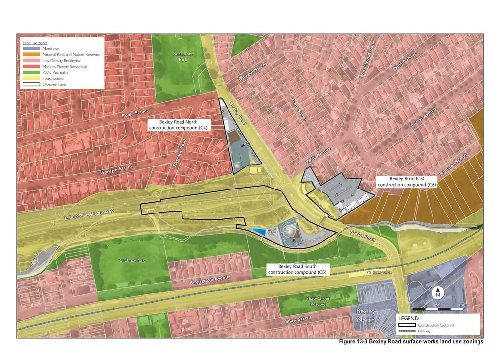
16 Bexley Road surface works The Bexley Road surface works would be located around the Bexley Road / M5 East Motorway interchange. Land use zonings and development controls in this area are regulated under the Canterbury LEP. Land to the south of the Bexley Road surface works is subject to the Rockdale LEP. The land use zonings within and around each of the sites forming part of the Bexley Road surface works are summarised in Table 13-4 and shown in Figure Existing land uses in the immediate vicinity of the Bexley Road surface works include the M5 East Motorway corridor and the M5 East Motorway western tunnel portals, the local and regional road network, residential lands, public recreation lands and land zoned for environmental conservation. The East Hills, Airport and Inner West railway line passes in an east-west direction to the south of the Bexley Road surface works, with the Bexley North railway station located on the railway line to the south east of the Bexley Road South compound (C5). Public recreation areas and infrastructure located around the Bexley Road surface works include: Illoura Park / Wolli Creek corridor (which connects to the Wolli Creek Regional Park further east), located immediately to the east of the Bexley Road East compound (C6) Beaumont Reserve, across Poole Street to the north of the Bexley Road North compound (C4) Kingsgrove Avenue Reserve, immediately to the south of the Bexley Road South compound (C5) Kingsbury Reserve (within M5 Linear Park) located about 700 metres to the west of the Bexley Road surface works, on the northern side of the M5 East Motorway Junee Crescent Reserve located about 650 metres to the north west of the Bexley Road North compound (C4) SJ Harrison Reserve located about 800 metres to the north east of the Bexley Road East compound (C6) Stotts Reserve, about 600 metres south east of the Bexley Road East compound (C6) Bexley North Park and Gilchrist Reserve, which are located about 350 metres south of the Bexley Road South compound (C5). These public recreation areas contain the Kingsgrove Bexley North Community Centre in the north, and Bexley Bowls Club in the south Several other, smaller, parks within one kilometre of the Bexley Road surface works. Sensitive and other special land uses (zoned as SP1 Special Uses) around the Bexley Road surface works include: Uniting Church on Miller Street, located about 850 metres north west of the Bexley Road North compound (C4) Clemton Park Public School, located about 750 metres to the north of the Bexley Road North compound (C4) Uniting Church on Barnsbury Grove, about 950 metres to the east of the Bexley Road East compound (C6) Booth College School for Christian Studies Bexley North, about 600 metres to the south-east of the Bexley Road South (C5) compound. The Bexley North mixed use centre is located along Bexley Road, about 300 metres to the Bexley Road South compound (C5). The mixed use centre is an important local focus for commerce and is associated with the Bexley North railway station. Further details of sensitive receivers and community infrastructure located around the Bexley surface works are provided in the Technical working paper: Social and economic (Appendix M). WestConnex New M
17 Table 13-4 Project site Bexley Road surface works land use zonings and development Land use zoning of the project site Construction ancillary facilities Bexley Road The site is zoned SP2 North Infrastructure (Road) under the Canterbury LEP. compound (C4). Bexley Road South compound (C5). Bexley Road East compound (C6). The site is partly zoned IN2 Light Industrial and partly zoned SP2 Infrastructure (Road) under the Canterbury LEP. The majority of the site is zoned SP2 Infrastructure (Road) under the Canterbury LEP. Small areas of the site encroach onto land zoned R3 Medium Density Residential along the northern boundary of the site. Use of the project site during The site would be used as a compound for tunnelling support activities. The site would be used as a compound for tunnelling support activities. The site would be used as a compound for ancillary works and car parking. Use of the project site during operation The site would be rehabilitated and returned to use as public open space. The site would be occupied by the Bexley Road motorway operations complex (MOC2) (refer below). The site would be rehabilitated and returned to use as public open space. Surrounding land use zonings and developments The site is bounded by Bexley Road to the east and the M5 East Motorway to the south, both of which are zoned SP2 Infrastructure (Road) under the Canterbury LEP. Immediately to the west of the site is land zoned R3 Medium Density Residential, and to the east across Bexley Road is land zoned R2 Low Density Residential. A parcel of RE1 Public Recreation land (Beaumont Park) lies to the north of the site, across Poole Street. The site is bounded by Bexley Road to the east and the M5 East Motorway to the north, both of which are zoned SP2 Infrastructure (Road) under the Canterbury LEP. Land to the south and west is zoned RE1 Public Recreation under the Canterbury and Rockdale LEPs and is associated with Kingsgrove Avenue Reserve and the Wolli Creek canal. The site lies between land zoned SP2 Infrastructure (Road) to the west and south (Bexley Road and the M5 East Motorway), R2 Low Density Residential to the north, and E1 National Parks and Nature Reserves to the east (Illoura Park, as western part of the Wolli Creek corridor). WestConnex New M
18 Project site Land use zoning of the project site Operation ancillary facilities Bexley Road The site is partly zoned IN2 South motorway Light Industrial and partly zoned operations SP2 Infrastructure (Road) under complex the Canterbury LEP. (MOC2). Use of the project site during The site would be occupied by the Kingsgrove South compound (C2). Use of the project site during operation Operational ancillary infrastructure associated with the Bexley Road South motorway operations complex (MOC2), including the Bexley Road South emergency smoke extraction facility. Surrounding land use zonings and developments The site is bounded by Bexley Road to the east and the M5 East Motorway to the north, both of which are zoned SP2 Infrastructure (Road) under the Canterbury LEP. Land to the south and west is zoned RE1 Public Recreation under the Canterbury and Rockdale LEPs and is associated with Kingsgrove Avenue Reserve and the Wolli Creek canal. WestConnex New M
19
20 (blank page) WestConnex New M
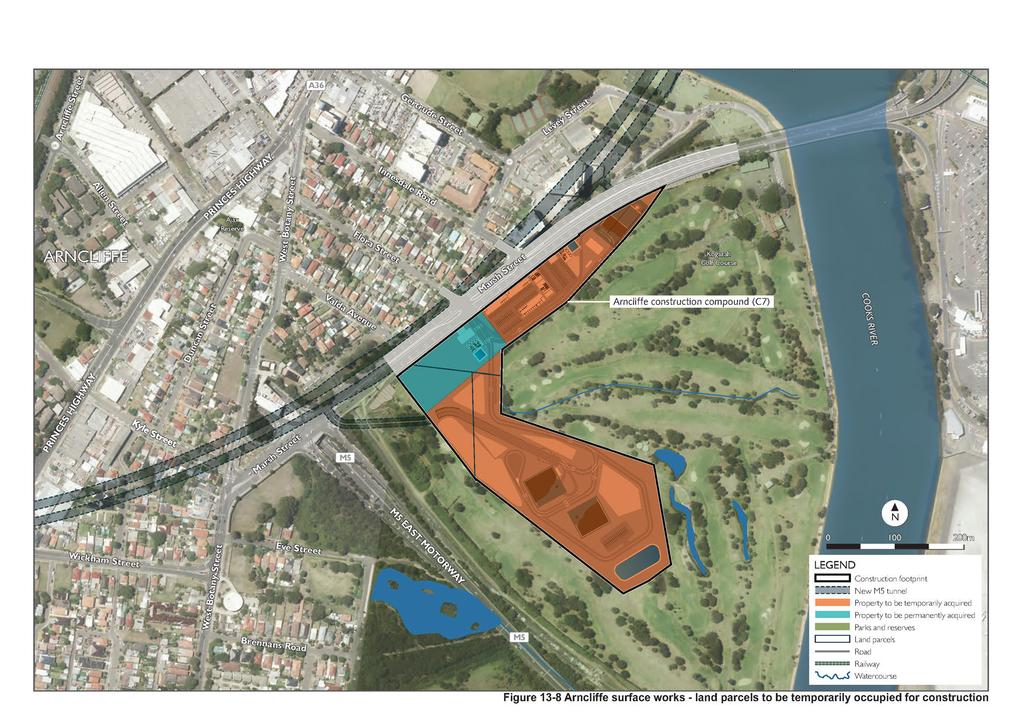
21 Arncliffe surface works The Arncliffe surface works would be located on land currently used as the Kogarah Golf Course. Land use zonings and development controls applicable to the Kogarah Golf Course (and to land south to around Bay Street) are detailed in the Cooks Cove SREP. Land around the golf course site is subject to Rockdale LEP south of the Cooks River and Marrickville LEP north of the Cooks River. The Arncliffe surface works would be located on land intended for land use transition in the future. The site is currently occupied by the Kogarah Golf Course, but is zoned under the Cooks Cove SREP for future infrastructure (special uses), employment (trade and technology) and open space uses. Action has not been taken at this time to give effect to these proposed future uses of the site. The land use zonings within and around each of the sites forming part of the Arncliffe surface works are summarised in Table 13-5 and shown in Figure Existing land uses in the immediate vicinity of the Arncliffe surface works include the M5 East Motorway corridor, the local and regional road network, residential lands, public and private recreation lands. Sydney Airport lies east of the site, across the Cooks River. The Main Southern railway line passes in a north-south direction west of the Arncliffe surface works, with the Arncliffe railway station located around 500 metres west of the Arncliffe compound (C7). Public recreation areas and infrastructure located around the Arncliffe surface works include: Cahill Park immediately to the north of the Arncliffe surface works, across Marsh Street Tempe Recreation Reserve to north of the Arncliffe surface works, across the Cooks River Riverine Park to the south of the Arncliffe surface works, across the M5 East Motorway corridor Kyeemagh, Barton Park, Banksia Field, Muddy Creek and White Oak Reserves around 500 metres to one kilometre to the south, around Muddy Creek Arncliffe Park on Wollongong Road, around one kilometre to the west of the Arncliffe surface works Several other, smaller, parks within one kilometre of the Arncliffe surface works Sensitive and other special land uses around the Arncliffe surface works include: St George Rowing Club to the north of the Arncliffe surface works, within Cahill Park and adjacent to the Cooks River Wolli Creek Islamic Mosque, around 400 metres to the west of the Arncliffe surface works Arncliffe Scots Sports and Social Club, around 600 metres to the west of the Arncliffe surface works Arncliffe Fire Station, around 400 metres to the south west of the Arncliffe surface works St Francis Xavier's Catholic Primary School around 650 metres to the south west of the Arncliffe surface works Arncliffe Public School, around 750 metres to the south west of the Arncliffe surface works. Significant areas of commercial land use zonings and development stretch along a corridor to the west and south west of the Arncliffe surface works, from around Arncliffe in the north to around Rockdale in the south. These commercial areas area associated with the Princes Highway and the Main Southern railway line, with more extensive development located around the Rockdale town centre. Further details of sensitive receivers and community infrastructure located around the Arncliffe surface works are provided in the Technical working paper: Social and economic (Appendix M). WestConnex New M
22 Table 13-5 Arncliffe surface works land use zonings and development Project site Land use zoning Use during Construction ancillary facilities Arncliffe compound (C7). The north of the site zoned Trade and Technology. The south of the site is zoned Open Space under the Cooks River SREP. A corridor zoned for Special Uses (as part of the historical F6 corridor) bisects the site. Operation ancillary facilities Arncliffe The north of the motorway site zoned Trade operations and Technology. complex The south of the (MOC3). site is zoned Open Space under the Cooks River SREP. Land along the southern boundary of the site is zoned Special Uses. The site would be used as a compound for civil infrastructure works and tunnelling support activities. The site would be occupied by the Arncliffe compound (C7). Use during operation Part of the site would be occupied by the Arncliffe motorway operations complex (MOC3). The remainder would be rehabilitated and returned for ongoing recreational uses or potential development as a permissible use(s) under the Cooks Cove SREP (trade and technology, or open space). Operational ancillary infrastructure associated with the Arncliffe motorway operations complex (MOC3), including the Arncliffe emergency smoke extraction facility and a ventilation facility. Surrounding land use zonings and developments The site is bounded along the north west by Marsh Road, which is zoned SP2 Infrastructure (Road) under the Rockdale LEP. Between Marsh Street and Cahill Park (zoned RE1 Public Recreation) are residential areas zoned as R2 Low Density Residential and R4 High Density Residential. Two pockets of B4 Mixed Use land are located adjacent to the southern boundary of Cahill Park, on the eastern and western sides of the high density residential area. The Cooks River is unzoned (subject to the Cooks River SREP). Land further to the east forms the Sydney Airport site, which is zoned SP2 Infrastructure (Airport) under the Rockdale LEP. To the south of the site, across the corridor occupied by the M5 East Motorway are areas zoned for Open Space under the Cooks River SREP. An area of R2 Low Density Residential is located along West Botany Street. The site is bounded along the north west by Marsh Road, which is zoned SP2 Infrastructure (Road) under the Rockdale LEP. Between Marsh Street and Cahill Park (zoned RE1 Public Recreation) are residential areas zoned as R2 Low Density Residential and R4 High Density Residential. Two pockets of B4 Mixed Use land are located adjacent to the southern boundary of Cahill Park, on the eastern and western sides of the high density residential area. Land immediately to the east of the site is zoned for Trade and Technology, and for Open Space under the Cooks Cove SREP. These zonings continue eastward until the unzoned Cooks River, and the Sydney Airport (SP2 Infrastructure (Airport)) beyond that. To the south of the site, across the corridor occupied by the M5 East Motorway are areas zoned for Open Space under the Cooks River SREP. An area of R2 Low Density Residential is located along West Botany Street. WestConnex New M

23
24 (blank page) WestConnex New M
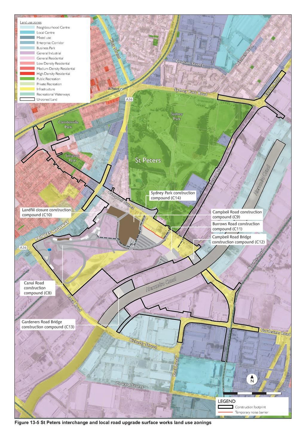
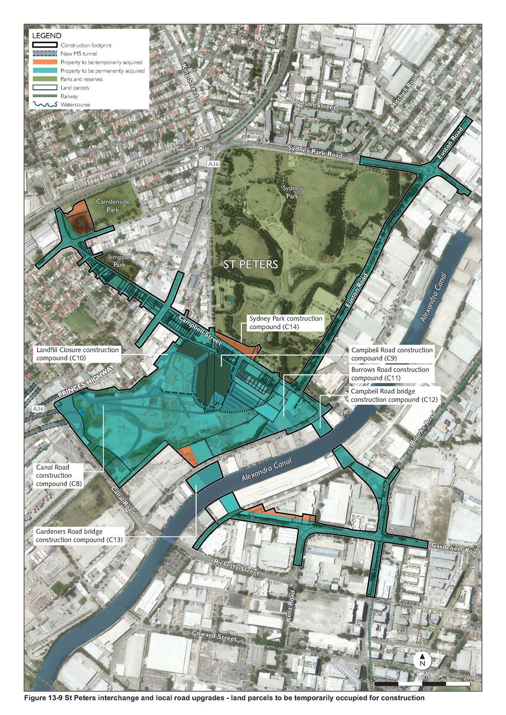
25 St Peters interchange and local road upgrade surface works The St Peters interchange and local road upgrade surface works would be centred on the St Peters interchange (former Alexandria Landfill site) and local roads around the south and east of Sydney Park. The St Peters interchange would span the local government boundary between Marrickville and Sydney that broadly bisects the Alexandria Landfill site in a north east to south west direction. Local road upgrade works would also cross the local government area boundary between Sydney and Botany Bay, which lies along Gardeners Road, to the east of Alexandra Canal. Land use zonings and development controls in this area are regulated under: The Marrickville LEP for the western portion of the Alexandria Landfill site, and areas to the south and west. The Sydney LEP for the eastern portion of the Alexandria Landfill site, and areas to the north and east (and north of Gardeners Road). The Botany Bay LEP for areas to the south of Gardeners Road. The land use zonings within and around each of the sites forming part of the St Peters interchange and local road upgrade surface works are summarised in Table 13-6 and shown in Figure Existing land uses in the immediate vicinity of the St Peters interchange and local road upgrade surface works include the Alexandria Landfill (to be closed as part of the project), which currently occupies the majority of the St Peters interchange works site and industrial lands. Adjacent land uses include an enterprise corridor along the Princes Highway, general industrial lands, local and arterial roads, Sydney Park to the north and Alexandra Canal to the east. Surrounding land uses include the residential neighbourhoods of St Peters, Sydenham and Newtown, as well as general residential and industrial areas of Alexandria to the east. Public recreation areas and infrastructure include: Sydney Park, in which the Sydney Park compound (C14) would be located, is to the north of the St Peters interchange Simpson Park, to the north of local road upgrade works along Campbell Street May Street Reserve, on the corner of May Street / Unwins Bridge Road / Campbell Street Camdenville Park, to the north of local upgrade works along Bedwin Road and to the west of May Street Roswell Playground, around 180 metres to the west of the Canal Road compound (C8) and the St Peters motorway operations complex (MOC4) Sydnenham Green, around 500 metres to the south west of the Canal Road compound (C8) and the St Peters motorway operations complex (MOC4). Sensitive and other special land uses include: St Peters Public School, around 150 metres to the west of the St Peters interchange (former Alexandria Landfill) site The St Peters Church of England, around 150 metres to the west of the St Peters interchange (former Alexandria Landfill) site Camdenville Public School, around 250 metres to the north of local road upgrades at Bedwin Road. The Building Blocks Early Childhood, to the north of local road upgrade works along Bourke Road/ Bourke Street Hotel Ibis Budget, on the Princes Highway, immediately adjacent to the St Peters interchange (Alexandria Landfill) site. WestConnex New M
26 An important commercial enterprise corridor is established along the Princes Highway, immediately to the west of the St Peters interchange and local road upgrade surface works. Other significant areas of commercial activity include those around the Bourke Road/ Bourke Street/ Gardeners Road intersection, and associated with the Sydney Airport. Further details of sensitive receivers and community infrastructure located around the Arncliffe surface works are provided in the Technical working paper: Social and economic (Appendix M). WestConnex New M
27 Table 13-6 Project site St Peters interchange and local road upgrade surface works land use zonings and development Land use zoning of the site project Use of the project site during Use of the operation project site during Surrounding land use zonings and developments Surface road works (St Peters interchange local road upgrades) St Peters Within the Marrickville LGA, the Surface road Operational road infrastructure. Most land to the north east, east and interchange majority of the site is zoned IN1 General Industrial, with pockets of IN2 Light Industrial land in the north west and south west corners and a strip of B6 Enterprise Corridor along the Princes Highway frontage. works. south of the site is zoned IN1 General Industrial, with some pockets of B7 Business Park located along Alexandra Canal to the north east and around Canal Road to the south east. The site is bounded to the east by an unzoned section of Alexandra Canal. Within the Sydney LGA, the site is a mix of SP2 Infrastructure (Road) and IN1 General Industrial land. Disturbed areas adjacent to operational road infrastructure would be rehabilitated and landscaped. Subject to future detailed design and the requirements of the future M4-M5 Link, parts of the site not required for road infrastructure may be contemplated for separate future redevelopment. A strip of B6 Enterprise Corridor land lies along the Princes Highway to the west of the site, beyond which land is mostly zoned R2 Low Density Residential with some areas of IN1 General Industrial and IN2 Light Industrial along the Main Southern Railway line. To the north of the site, the principal land use is Sydney Park (RE1 Public Recreation), with a triangle of R1 General Residential and B4 Mixed use land near the intersection of the Princes Highway and Campbell Street. WestConnex New M
28 Project site Upgrade and widening of Euston Road. Upgrade, widening and extension of Bedwin Road / Campbell Street / Campbell Road. Land use zoning of the project site The site is zoned SP2 Infrastructure (Road) under the Sydney LEP for a short distance north of Campbell Road and north from the Sydney Park Road/ Huntley Street intersection. Between these areas, generally along Sydney Park, the site is zone IN1 General Industrial. Within the Marrickville LGA (from Bedwin Road east to the western boundary of Sydney Park), the site includes a mix of IN1 General Industrial, R1 Low Density Residential, RE1 Public Recreation, B4 Mixed Use and IN2 Light Industrial land use zonings. In these areas the existing road corridor has been zoned consistent with adjacent land use zonings. Within the Sydney LGA (west of the western boundary of Sydney Park), the site is zoned SP2 Infrastructure (Road). The land comprising Alexandra Canal is unzoned. Use of the project site during Surface road works and continued operation of local surface roads. Surface road works and continued operation of local surface roads. Use of the project site during operation Operational road infrastructure. Disturbed areas adjacent to operational road infrastructure would be rehabilitated and landscaped consistent with the existing road corridor. Operational road infrastructure. Disturbed areas adjacent to operational road infrastructure would be rehabilitated and landscaped consistent with the existing road corridor. Surrounding land use zonings and developments Land along the eastern side of Euston Road is zoned IN1 General Industrial. Along the western side, zonings include RE1 Public Recreation (Sydney Park) south of Sydney Park Road and a combination of B4 Mixed Use and IN2 Light Industrial to the north of Sydney Park Road. Bedwin Road is flanked by RE1 Public Recreation (Camdenville Park) to the north and IN1 General Industrial to the south. Land uses adjacent to Campbell Street are varied, with land along the south including R2 Low Density Residential west of the Princes Highway and a mix of B4 Mixed Use, IN1 General Industrial and IN2 Light Industrial to the east of the Princes Highway. Along its northern side including R1 General Residential, B4 Mixed Use, B7 Business Park and RE1 Public Recreation (Simpson Park). Campbell Road is generally surrounded by land zoned IN1 General Industrial and B7 Business Park. The key exceptions are Sydney Park (RE1 Public Recreation) to the north, and the unzoned section of Alexandra Canal. WestConnex New M
29 Project site Upgrade and widening of Bourke Road / Bourke Street. Minor upgrade works on Unwins Bridge Road and May Street. Minor upgrade works on Albert Street. Land use zoning of the project site The majority of the site is zoned IN1 General Industrial under the Sydney LEP, consistent with the zoning of adjacent land. The part of the site from the new intersection between the Campbell Road extension and Bourke Road/ Bourke Street south to Gardeners Road is zoned SP2 Infrastructure (Road). The site is partly zoned R2 Low Density Residential (Unwins Bridge Road) and partly zoned IN2 Light Industrial (May Street) under the Marrickville LEP, consistent with the zoning of adjacent land. The site is zoned a mix of B6 Enterprise Corridor, IN2 Light Industrial and IN1 General Industrial under the Marrickville LEP. Use of the project site during Surface road works and continued operation of local surface roads. Surface road works and continued operation of local surface roads. Surface road works and continued operation of local surface roads. Use of the project site during operation Operational road infrastructure. Disturbed areas adjacent to operational road infrastructure would be rehabilitated and landscaped consistent with the existing road corridor. Operational road infrastructure. Disturbed areas adjacent to operational road infrastructure would be rehabilitated and landscaped consistent with the existing road corridor. Operational road infrastructure. Disturbed areas adjacent to operational road infrastructure would be rehabilitated and landscaped consistent with the existing road corridor. Surrounding land use zonings and developments Bourke Road is mainly adjacent to IN1 Industrial land, with some small areas of B7 Business Park and SP2 Infrastructure (Road) (at the site of the new intersection between the Campbell Road extension and Bourke Road). Bourke Street to the south of Gardeners Road is flanked by land zoned B4 Mixed Use. Unwins Bridge Road is adjacent to R2 Low Density Residential land to the east and a mix of IN1 General Industrial and IN2 Light Industrial land to the west. May Street is adjacent to Camdenville Park (RE1 Public Recreation), R2 Low Density Residential and B5 Business Development land use zonings to the west. To the east, it is adjacent to a mix of R1 General Residential, R2 Low Density Residential, B5 Business Development and B7 Business Park land use zonings. Albert Street is surrounded on both sides by a mix of B6 Enterprise Corridor, IN2 Light Industrial and IN1 General Industrial land. WestConnex New M
30 Project site Permanent road and intersection closures at: Harber Street Land use zoning of the project site The site is zoned SP2 Infrastructure (Road) under the Sydney LEP. Use of the project site during Surface road closure works. Use of the project site during operation Disturbed areas would be rehabilitated and returned for permissible uses consistent with land use zonings or open space. Surrounding land use zonings and developments Road and intersection closures are surrounded by land zoned SP2 Infrastructure (Road). Campbell Lane Woodley Street Holland Street The Campbell Road / Woodley Street intersection. Widening extension Gardeners Road. and of The site is zoned SP2 Infrastructure (Road) under the Sydney LEP and Botany Bay LEP. Surface road works and continued operation of local surface roads. Operational road infrastructure. Disturbed areas adjacent to operational road infrastructure would be rehabilitated and landscaped consistent with the existing road corridor. Gardeners Road is adjacent to IN1 Industrial land to the north, and B4 Mixed Use land to the south. WestConnex New M
31 Project site Land use zoning of the project site Construction ancillary facilities Canal Road The site is zoned IN1 General Industrial and IN2 Light Industrial compound (C8). under the Marrickville LEP. Campbell Road compound (C9). The site is zoned SP2 Infrastructure (Road) under the Sydney LEP. Use of the project site during The site would be used as a compound for civil infrastructure works and tunnelling support activities. The site would be used as a compound for civil infrastructure works. Use of the project site during operation Part of the site would be occupied by the St Peters motorway operations complex (MOC4) (refer below) and road infrastructure associated with the St Peters interchange. Disturbed areas adjacent to the motorway operations complex and operational road infrastructure would be rehabilitated and landscaped. Subject to future detailed design and the requirements of the future M4-M5 Link, parts of the site not required for the motorway operations complex and road infrastructure may be contemplated for separate future redevelopment. The site would be rehabilitated and landscaped. Subject to future detailed design and the requirements of the future M4-M5 Link, parts of the site may be contemplated for separate future redevelopment. Surrounding land use zonings and developments Most land around the site is zoned IN1 General Industrial. A strip of B6 Enterprise Corridor land lies along the Princes Highway to the west of the site, beyond which land is mostly zoned R2 Low Density Residential with some areas of IN1 General Industrial and IN2 Light Industrial along the Main Southern Railway line. The site fronts Campbell Road (zoned SP2 Infrastructure (Road)) to the north, beyond which is Sydney Park (RE1 Public Recreation). Other land around the site includes SP2 Infrastructure (Road) to the south east and IN1 General Industrial to the south west. WestConnex New M
32 Project site Landfill closure compound (C10). Burrows Road compound (C11). Campbell Road bridge compound (C12). Gardeners Road Bridge compound (C13) Sydney Park compound (C14) Land use zoning of the project site The site is zoned IN1 General Industrial under the Sydney LEP. The site is zoned SP2 Infrastructure (Road) and IN1 General Industrial under the Sydney LEP. The site is zoned IN1 General Industrial under the Sydney LEP. The site is zoned IN1 General Industrial under the Sydney LEP. The site is zoned RE1 Public Recreation under the Sydney LEP. Use of the project site during The site would be used as a compound for civil infrastructure works, administration and Alexandria landfill closure works. The site would be used as a compound for civil infrastructure works, administration and car parking. The site would be used as a compound for civil infrastructure works. The site would be used as a compound for civil infrastructure works. The site would be used as a compound for civil infrastructure works, administration and car parking. Use of the project site during operation The site would be landscaped. Parts of the site not required for road infrastructure may be contemplated for separate future redevelopment. The site would be used as the Burrows Road motorway operations complex (MOC5) The site would be rehabilitated and returned to use as public open space or other permissible uses. The site would be rehabilitated and returned to use as public open space. The site would be rehabilitated returned to use as public open space or other permissible uses. Surrounding land use zonings and developments The site is surrounded by IN1 General Industrial, and IN2 Light Industrial and B6 Enterprise to the north. Most of the land around the site is zoned IN1 General Industrial, with the exception of land immediately to the north, which is zoned SP2 Infrastructure (Road). Most of the land around the site is zoned IN1 General Industrial, with the exception of land immediately to the east, which is an unzoned portion of Alexandra Canal. Most of the land around the site is zoned IN1 General Industrial, with the exception of land immediately to the east, which is an unzoned portion of Alexandra Canal. Land to the north is zoned as RE1 Public Recreation (Sydney Park) and SP2 Infrastructure (Road) to the south. Most of the remaining land is zoned as IN1 General industrial. Pockets of R1 (General residential) occur to the east and west. WestConnex New M
33 Project site Land use zoning of the project site Operation ancillary facilities St Peters The site is zoned IN1 General motorway Industrial and IN2 Light Industrial operations under the Marrickville LEP. complex (MOC4). Burrows Road motorway operations complex (MOC5) The site is zoned SP2 Infrastructure (Road) and IN1 General Industrial under the Sydney LEP. Use of the project site during The site would be occupied by the Canal Road compound (C8). The site would be occupied by the Burrows Road compound (C11). Use of the project site during operation Operational ancillary infrastructure associated with the St Peters motorway operations complex (MOC1), including the eastern ventilation facility. Operational ancillary infrastructure associated with the Burrows Road motorway operations complex (MOC5) Surrounding land use zonings and developments Most land around the site is zoned IN1 General Industrial. A strip of B6 Enterprise Corridor land lies along the Princes Highway to the west of the site, beyond which land is mostly zoned R2 Low Density Residential with some areas of IN1 General Industrial and IN2 Light Industrial along the Main Southern Railway line. Most of the land around the site is zoned IN1 General Industrial, with the exception of land immediately to the north, which is zoned SP2 Infrastructure (Road). WestConnex New M
34 (blank page) WestConnex New M
35
36 (blank page) WestConnex New M
37 13.3 Assessment of potential impacts The preferred design for the project has been developed such that it minimises the need for surface property acquisition and other impacts to residential properties and public open space and reserves where reasonable and feasible to do so. This has been balanced with maximising opportunities for beneficial re-use of the properties required for that would be surplus to operational needs. Notwithstanding this design intent, and operation of the project would result in temporary and permanent impacts on land use and property. Properties requiring acquisition to allow for the and operation of the project are referred to as directly affected land, and include: Properties requiring partial acquisition, where only a portion of the property is required Properties requiring full acquisition, where the majority of the property would be directly impacted by the project. In the event that land is required that is not currently owned by the NSW Government, discussions would be held with the affected property owner concerning the purchase or lease of the land required during. All compulsory acquisition required for the project would be undertaken in accordance with the Land Acquisition (Just Terms Compensation) Act 1991 (NSW). Relocation and some other categories of expenses would be claimable under this Act Construction Potential land use and property impacts associated with of the project would include: Changes to land use and property resulting from acquisition of properties in order to construct the project Temporary alteration and / or temporary disruption to property accesses resulting from traffic diversions for road Temporary occupation of land, to allow for of the project, which would temporarily restrict the development potential of that land Settlement of the surface as a result of tunnelling activities. OEH estate reserved under the National Parks and Wildlife Act 1974 Potential indirect impacts as a result of changes to land use and property are considered to predominantly relate to social and economic values. Chapter 15 (Social and economic) provides detail relating to these potential impacts. OEH estate The project would not directly impact any OEH estate reserved under the National Parks and Wildlife Act The project would be located upstream of the Towra Point Wetlands and therefore the following matters outlined in the Guidelines for developments adjoining land and water managed by Department of Environment, Climate Change and Water (DECCW 2010) were given consideration: Erosion and sediment control Stormwater runoff Wastewater Erosion, sedimentation and drainage controls would be implemented during of the project and include water treatment plants, sediment fencing, check dams, temporary ground stabilisation, diversions berms or site regrading. These controls would be consistent with Managing Urban Stormwater Soils and Construction Volumes 1 and 2, 4th Edition (the Blue Book) (Landcom, 2004). Stormwater runoff and water would be diverted to water treatment plants that would treat water, surface water runoff and groundwater inflows. Based on the design of the project, it is anticipated that the discharged water quality would be higher than the current water quality of the receiving environments. Water quality of the treated wastewater and outflow velocities WestConnex New M
38 would be in accordance with the requirements of the relevant agencies and local councils, including Sydney Water and the EPA. Water quality criteria and targets are provided in Chapter 16 (Soil and water quality). Residual impacts to downstream OEH estates are therefore considered to be unlikely and not significant. Further information relating to erosion and sediment control, stormwater runoff and wastewater quality criteria / targets can be found in Chapter 16 (Soil and water quality) and Chapter 18 (Flooding and drainage). Temporary occupation Temporary occupation of land would be required to allow for of the project. Occupation of land would restrict the development potential of that land for the duration of. Table 13-7 summarises the potential implication of compounds and activities on existing land use zonings and development potential. Further assessment of residual lots during and operation is provided in Section and Section In most cases, land that is occupied for compounds and activities would be rehabilitated at the end of the period and returned for potential development for permissible uses under land use zoning provisions. The key exception would be where land used for purposes is required permanently such as for one of the five motorway operations complexes. Where land affected by is not required for the ongoing operation of the New M5, it would be rehabilitated and made available for potential sale and/ or redevelopment for a permissible use. In some cases, including the Landfill closure compound site and the surplus land around the St Peters interchange, there may be an opportunity to review the current land use zoning of the affected land. The relevant local council would be consulted in these areas to determine whether current land use zonings and permissible land use types remain appropriate following of the New M5. Temporary compounds located outside of the road reserve would occupy land temporarily, resulting in a temporary change in land use during works. Existing land uses, site accessibility and potential opportunities to co-locate compounds near or within the footprint of permanent operational facilities have been considered when determining the size and location of facilities. The 30 properties (115 parcels of land) that would be directly impacted by are detailed in Appendix D. Some of these properties would also be directly impacted by operational infrastructure (refer to Section ). Of these 30 properties: Five properties (51 parcels of land) are already owned by Roads and Maritime Four properties (6 parcels of land) are owned by other NSW Government agencies Six properties (7 parcels of land) are privately owned. Fifteen properties (51 parcels of land) are owned by Local Government. Figure 13-6 to Figure 13-9 show the land parcels currently anticipated to be directly impacted during of the project, including partial and full acquisitions. The extent of property acquisition would be reviewed and confirmed during detailed design of the project. All acquisitions would be carried out consistently with the principles in the Land Acquisition (Just Terms Compensation) Act 1991 (NSW) and the Land Acquisition Information Guide (Roads and Maritime, 2012c). WestConnex New M
39 Existing uses and development of sites that would be directly impacted by and returned / modified to a non-project related land use include: Four properties that are currently not occupied by significant development and used for open space adjacent to the M5 East Motorway corridor (ie properties within M5 Linear Park) Three properties currently occupied by industrial developments Three properties currently used for the Kogarah Golf Course. Temporary access impacts Construction works and the location of temporary compounds may result in temporary impacts to access to adjacent properties. Impacts to property access would be avoided where possible, and where unavoidable, property owners would be consulted in order to develop an appropriate alternative access arrangement. WestConnex New M
40 (blank page) WestConnex New M
41
42 (blank page) WestConnex New M
43
44 (blank page) WestConnex New M
45
46 (blank page) WestConnex New M
47
48 (blank page) WestConnex New M
49 Table 13-7 Potential temporary impacts on land use and development potential Project site Potential impacts on land use and development potential Western surface works M5 East Motorway The M5 East Motorway integration works and of the western portals would be carried out within the existing motorway integration works and road reserve. These works would be consistent with the current and future use of the land as road infrastructure, and western portals. would not adversely impact on land use or development potential. The potential impact of the M5 East Motorway integration works and of the western portals is therefore not considered to be significant. Kingsgrove North compound (C1). The Kingsgrove North compound would be partly located within the existing M5 East Motorway corridor, and partly on land currently zoned and used for public recreation and light industrial development. The area of land currently used for public recreation (Beverly Grove Park) would not be available during of the project. Alternative pedestrian and bicycle access arrangements would be provided around the northern boundary of the compound during this period. The use of Beverly Grove Park would be temporarily restricted during, and would be rehabilitated and returned for public recreation at the end of. Other public recreation sites in the area, including Beverly Hills Park and Clemton Park would remain and would not be affected during. The potential impact to users is therefore considered to be not significant. The current zoning and use of Beverly Grove Park for public recreation limits the potential for development of the site for other permissible uses. The potential for of the project to significantly affect the development potential of the site would therefore be low. Kingsgrove South compound (C2). Commercial Road compound (C3). The eastern end of the Kingsgrove North compound would occupy land currently zoned and occupied by light industrial development. This light industrial development would need to be relocated, and current infrastructure on the site demolished in the initial stages of the program. The project would therefore restrict the use of this land for permissible uses, including as light industrial development, for the duration of the period. The majority of the site would be returned for use as light industrial and or other permissible development at the end of the period. Given the temporary duration of the works, impacts to this land used for light industrial development is not considered to be significant. The Kingsgrove South compound would affect land within the existing motorway road reserve (which includes M5 Linear Park). These works would be consistent with the current and future use of the land as road infrastructure, and would not adversely impact on land use or development potential. Impacts are therefore not considered to be significant. The Commercial Road compound would occupy land currently zoned and occupied by light industrial development. This light industrial development would need to be relocated, and current infrastructure on the site demolished in the initial stages of the program. The project would therefore restrict the use of this land for permissible uses, including as light industrial development, for the duration of the period. The site would be returned for use as light industrial and or other permissible development at the end of the period and therefore impacts are not considered to be significant. WestConnex New M
50 Project site Potential impacts on land use and development potential Bexley Road surface works Bexley Road North The Bexley Road North compound would affect currently undeveloped land within an existing road reserve. These works would be consistent with the current and future use of the land as road infrastructure, and would not adversely compound (C4). impact on land use or development potential. Impacts are therefore not considered to be significant. Bexley Road South compound (C5). Bexley Road East compound (C6). The Bexley Road South compound would affect currently undeveloped land within an existing road reserve (which includes M5 Linear Park). These works would be consistent with the current and future use of the land as road infrastructure, and would not adversely impact on land use or development potential. Impacts are therefore not considered to be significant. Most of the Bexley Road East compound would affect currently undeveloped land within an existing road reserve (which includes existing M5 East filtration plant). These works would be consistent with the current and future use of the land as road infrastructure, and would not adversely impact on land use or development potential. Impacts are therefore not considered to be significant. Those small areas of the compound that would encroach onto adjacent residential land would not affect existing developments on the land. There would be a temporary loss of development potential on the affected land for the duration of the works. As the works are only temporary, the impact is not considered to be significant. Arncliffe surface works Arncliffe The Arncliffe compound would be located on land currently used for the Kogarah Golf Course. Location of the compound (C7). compound on this site would affect the operation of the golf course and would require the golf course to operate as a 9 hole course rather than an 18 hole course for the duration of. The site is not currently developed for other permissible uses under the Cooks Cove SREP. The potential for such development would be restricted within the footprint of the compound for the duration of activities. Those parts of the disturbed site not required for the Arncliffe motorway operations complex (MOC3) would be rehabilitated and returned for potential future development consistent with land use zoning provisions. Therefore, impacts are not considered to be significant. St Peters interchange and local road upgrade surface works St Peters interchange The St Peters interchange would be located mostly on land currently used for the Alexandria Landfill. The potential continued operation of the landfill or other permissible industrial uses on the site would not be possible during. Surplus land on the site not used for road infrastructure in the future may be considered for redevelopment for a permissible use (which would not be for the purpose of continued landfilling).the change in land use is considered to be beneficial with land comprising road infrastructure, operational facilities, and open space. Part of the St Peters interchange would affect land subject to planning controls which expressly contemplate a road. The works on the site and the St Peters interchange itself are consistent with these controls and therefore the impact is not considered to be significant. WestConnex New M
51 Project site Local road upgrades Canal Road compound (C8). Campbell Road compound (C9). Landfill closure compound (C10). Burrows Road compound (C11). Campbell Road bridge compound (C12). Potential impacts on land use and development potential Most of the local road upgrades would be conducted on land currently zoned and used for road infrastructure. In some cases minor encroachment into attached land use zonings may be required during and for ancillary infrastructure (such as footpaths and bicycle paths) during operation. Local road upgrades would therefore be consistent with the current land use zoning and development of land in these areas. As the works are only temporary, the impact is not considered to be significant. In some cases, particularly with the Marrickville local government area, existing roads have adopted the land use zoning of adjacent residual land for example landscaping / open spaces / carks parks on Campbell Road. In these areas, the land affected by the project is currently occupied by or immediately adjacent to existing roads. Continued use of this land, in an upgraded form, would be consistent with current land use and development patterns and therefore impacts are not considered to be significant. The Canal Road compound would be located on land currently used for the Alexandria Landfill and commercial / industrial purposes. The potential continued operation of the landfill or other permissible industrial uses on the site would not be possible during. Most of the compound site would be used for the St Peters motorway operations complex (MOC4) during operation and there would be limited potential for further development of the site in the future. The change in use is not considered to represent a significant adverse impact to the development potential of the land given the small land take of the motorway operations complex. The Campbell Road compound would be located on land currently used for the Alexandria Landfill, and subject to planning controls which expressly contemplate road infrastructure. The potential continued operation of the landfill would not be possible during. The closure of the Alexandria Landfill and use of the land for the of road infrastructure would be consistent with the current planning controls for the land on which the compound would be located. Potential impacts are therefore not considered to be significant. The Landfill closure compound would be located on the Alexandria Landfill and is currently zoned as General Industrial. The potential continued operation of the landfill would not be possible during. The existing hardstand area for the compound would be utilised for site office, amenities, laydown and material storage areas. Upon completion of the project the compound components would demobilise and landscaping would occur. Surplus land on the site may be considered for redevelopment for a permissible use (which would not be for the purpose of continued landfilling). The change in use following completion of the project is considered to be beneficial to the land. No significant adverse impacts are anticipated. The Burrows Road compound would be located on land currently used for commercial / industrial purposes. The potential continued operation of the landfill or other permissible industrial uses on the site would not be possible during. Surplus land on the site not subject to planning controls which expressly contemplate road infrastructure in the future may be considered for redevelopment for a permissible use (which would not be for the purpose of continued landfilling). The change in use following completion of the project is considered to be beneficial to the land. No significant adverse impacts are anticipated. The Campbell Road bridge compound would be located on land currently zoned and occupied by industrial development. Use of the land for the compound would require relocation of the existing industrial operations and demolition of existing development on the site. Continued use of the site for these uses would not be possible during the period. The site would be rehabilitated and returned for potential future development of permissible uses under the land use zoning. As the works are only temporary, the impact on industrial operations is not considered to be significant. WestConnex New M
52 Project site Gardeners Road bridge compound (C13) Sydney Park compound (C14) Potential impacts on land use and development potential The Gardeners Road bridge compound would be located on land currently zoned and occupied by industrial development. Use of the land for the compound would require relocation of the existing industrial operations and demolition of existing development on the site. Continued use of the site for these uses would not be possible during the period. The site would be rehabilitated and returned for potential future development of permissible uses under the land use zoning. As the works are only temporary, the impact on land use and the development potential on the land is not considered to be significant. The Sydney Park compound would be located on land currently used for public recreation. Continued use of the site for permissible uses would not be possible during the period. The site would be rehabilitated and returned for potential future development of permissible uses under the current land use zoning (ie open space within Sydney Park). At the end of the period, the site would be rehabilitated. As the works are only temporary, the impact on recreational users is not considered to be significant. WestConnex New M
53 Settlement and subsidence Settlement along the tunnel route may occur in some areas as a result of volume loss during tunnel excavation, groundwater drawdown and subsequent ground consolidation. Areas most likely to be affected by settlement are usually where tunnelling is closest to the ground surface, around the main alignment tunnel portals and on and off ramps. Settlement of the surface can create tensile strains in buildings above and around the settlement. The extent of settlement, and the resultant strains affecting buildings, has been calculated for the project. Affected buildings have been assigned an indicative damage category, from negligible to very severe, based on the risk of damage to the buildings as a result of settlement. Damage categories of negligible to slight are acceptable as they represent potential aesthetic damage only (for example, minor cracking of plaster). Damage categories of moderate to very severe are related to serviceability and stability damage and therefore present significant risk of damage, potentially requiring major remedial works or demolition of the structure. Further details of the settlement assessment and anticipated damage categories for reference buildings are provided in Chapter 17 (Groundwater), in Section It is expected that settlement would stabilise within about two months of tunnel excavation occurring under a structure. A building condition survey would be undertaken within the preferred project corridor (the zone on the surface equal to 50 metres from the outer edge of the tunnels) and within 50 metres of surface works. Building condition surveys of potentially affected structures would be completed both before and after the works to identify existing damage and any damage due to the works. Where project induced settlement is deemed the cause of cracking, cracks would be filled, new external masonry cracks would be repointed for weather tightness, and depressions created by depressions would be rectified. A monitoring program would also be undertaken to ensure that settlement has stabilised before monitoring is completed. Relocation of Utilities It is likely that utilities and services located within or close to the project, including electricity, telecommunications (including optic fibre cables), sewer and water mains, would need to be relocated or realigned as part of of the project. This is particularly the case around areas of surface or shallow soil disturbance. The nature and extent of utility changes would be confirmed during the detailed design of the project, with appropriate relocation or replacement alternatives identified in consultation with the relevant utility provider. A summary of utilities that have been identified that would be protected or require adjustment / relocation is provided in Table Changes to utilities outside of the project footprint would be subject to separate environmental assessment and approval processes. Details on the provision of utilities to supply the project can be found in Chapter 5 (Project description). WestConnex New M
54 Table 13-8 Zone Western surface works Arncliffe surface works Main alignment tunnels St Peters interchange Changes to access for the local road upgrades Service Authority Ausgrid Summary of utilities potentially affected Low-voltage supply for lighting on shared pathway Potential action The asset would be relocated where affected by the works. Telstra Optic fibre and copper cables Combination of protect in place where feasible to do so and relocation. Sydney Water Sewers Combination of protect in place, where feasible to do so, and relocation. Ausgrid Low-voltage cables The asset would be relocated where affected by the works. Jemena Gas Steel secondary gas The asset would be protected in place. main Sydney Water Desalination pipeline The asset would be protected in place. Telstra Optic fibre and copper The asset would be protected in place. cable Gorodok Ethane and ethylene The project has been designed to avoid gas pipeline impacts to these assets. Jemena Gas Gas main The project has been designed to avoid impacts to these assets. Optus Optic fibre cables The project has been generally designed to avoid impacts to these assets. However, where avoidance is not possible, they would be protected in place. Shell High pressure multiproduct The project has been designed to avoid pipeline impacts to these assets. Viva Energy High pressure oil The project has been designed to avoid pipeline impacts to these assets. Sydney Water The South western The project has been designed to avoid suburbs ocean outfall impacts to the SWSOOS. Other sewers sewer (SWSOOS) would be protected in place. and five other sewers Transgrid 330kV feeder cables The project has been designed to avoid impacts to these assets. Ausgrid 33kV and 132kV high The asset would be protected in place voltage transmission cable Disconnections Various gas, water, sewer, power and communications Utility connections would be disconnected prior to demolition works. assets Jemena Gas Gas main The asset would be protected in place. Optus Optic fibre cable The asset would be protected in place. Sydney Water Desalinisation The asset would be protected in place. pipeline, two sewers, and three water mains Telstra Optic fibre and copper The asset would be protected in place. cables Transgrid 330kV high voltage The asset would be protected in place. cable Canal Road AARNet Optic fibre cable The asset would be protected in place. Ausgrid 33kV and 132kV high The asset would be protected in place. voltage cables and a low voltage cable Optus Optic fibre cable The asset would be protected in place. WestConnex New M
55 Zone Gardeners Road extension Service Summary of utilities Potential action Authority potentially affected Sydney Water Desalinisation pipeline The asset would be protected in place. and water mains Telstra Optic fibre and copper The asset would be protected in place. cable Transgrid 330kV feeder cable The project has been designed to avoid impacts to these assets. However, activities would be monitored and the assets would be protected in place where required. AARNet Optic fibre cable The asset would be relocated where affected by the works. Ausgrid Jemena Gas 132kV high voltage and low voltage cables Secondary gas main and two nylon gas mains The 132kV transmission cable would be monitored and protected in place. Low voltage cables would be relocated. An integrity test would be undertaken for the secondary gas main and permanent protection provided where necessary. The nylon gas mains would be relocated where required. Luminet Optic fibre cable The cable would be monitored and temporary protection provided during where necessary. NBN Optic fibre cable The assets would be monitored and either relocated where affected or protected in place during. Nextgen Optic fibre cable The assets would be monitored and either relocated where affected or protected in place during. Optus Southern cross international optic fibre cable including cable station, and an ordinary optic fibre cable Temporary or permanent protection would be provided as necessary for the Southern cross international optic fibre cable. The ordinary optic fibre cable would be relocated where affected by works, and monitored and protected in place for other locations. Pipe Networks Optic fibre cable The asset would be monitored and protected in place. Primus Optic fibre cable The asset would be monitored and protected in place. Sydney Water Telstra Sewers and water mains Optic fibre and copper cables The assets would be monitored and either relocated/ re-laid where affected or protected in place during. The assets would be monitored and either relocated where affected or protected in place during. Uecomm Optic fibre cable The assets would be monitored and either relocated where affected or protected in place during. Verizon Optic fibre cable The assets would be monitored and either relocated where affected or protected in place during. Vocus Optic fibre cable The assets would be monitored and either relocated where affected or protected in place during. WestConnex New M
56 Operation Potential impacts on land use associated with operation of the project would include: Permanent acquisition of properties Changes to site accessibility Formation of residual lots, with potential implications for the development potential of those lots. Changes to development patterns on the project s operational sites Implications for development patterns beyond the boundaries of the project s operational sites. Properties required for the project A number of properties would be required to accommodate the following operational components for the project: Around the western portals, where the existing motorway road corridor needs to be widened The five motorway operations complexes for the project, at Kingsgrove (MOC1), Bexley Road (MOC2), Arncliffe (MOC3), St Peters (MOC4) and at Burrows Road (MOC5) The St Peters interchange works In some areas along local road upgrade works, where road widening or realignment works extend beyond the existing road reserve and/ or road infrastructure footprint. There are 143 properties (364 parcels of land) that would be directly impacted by operational infrastructure. These are detailed in Appendix D and consist of: Thirty nine properties (218 parcels of land) already owned by Roads and Maritime Six properties (10 parcels of land) to be acquired from other NSW Government agencies Seventy six properties (102 parcels of land) to be acquired from private owners Five properties are owned by utility providers (6 parcels of land) Seventeen properties (28 parcels of land) are owned by councils. Figure to Figure show the properties currently anticipated to be directly impacted during operation of the project. Where a property is not owned by Roads and Maritime, full or partial acquisition of the property would be required. The extent of property acquisition would be reviewed and confirmed during detailed design of the project. All acquisitions would be undertaken consistently with the principles in the Land Acquisition (Just Terms Compensation) Act 1991 and the Land Acquisition Information Guide (Roads and Maritime, 2012c). WestConnex New M
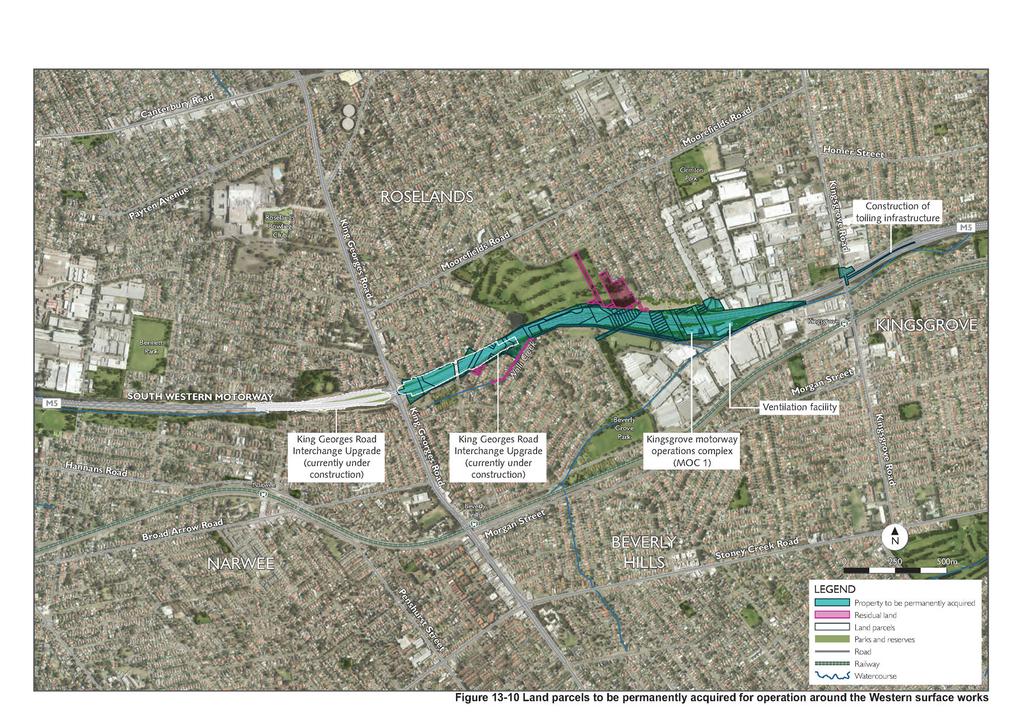
57
58 (blank page) WestConnex New M
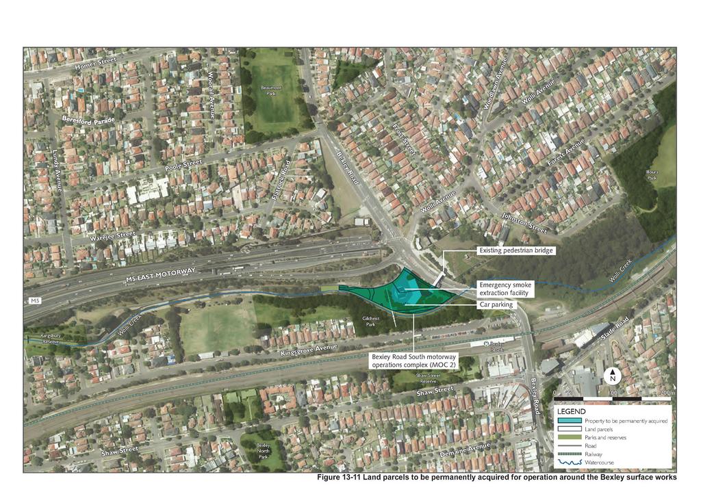
59
60 (blank page) WestConnex New M
61
62 (blank page) WestConnex New M
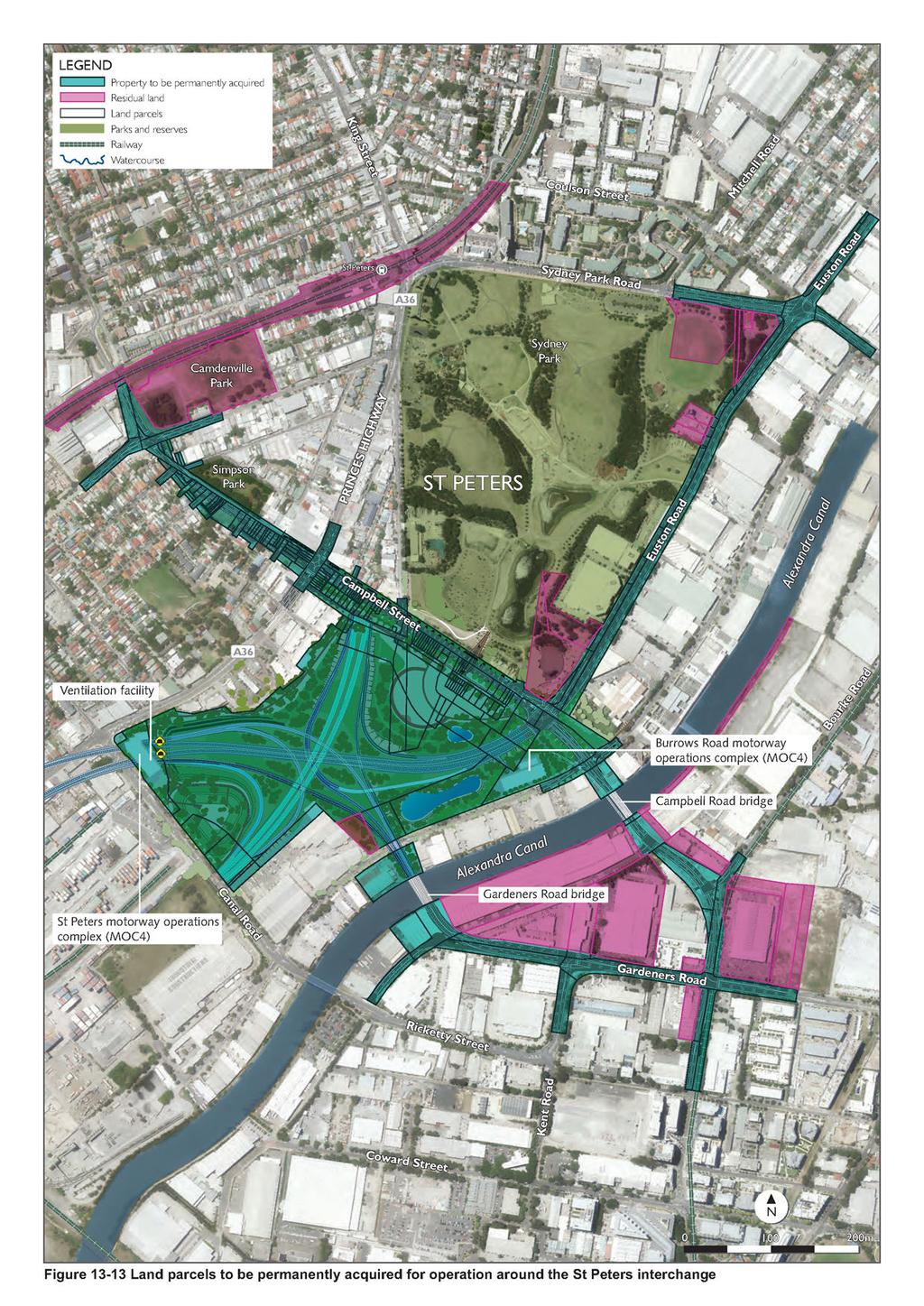
63
64 (blank page) WestConnex New M

65 Subsurface acquisition In addition to the properties affected by surface activities, land (or interests in land such as easements) below the surface of the ground would be acquired. This is called subsurface acquisition and is illustrated in Figure Figure Example of sub-surface stratum acquisition The Land Acquisition (Just Terms Compensation) Act 1991 (NSW) provides that compensation is not payable for the majority of subsurface acquisition of land or easements, unless specific circumstances as detailed in that Act apply. Appendix C of the Roads and Maritime Land Acquisition Information Guide (Roads and Maritime 2014d) sets out in detail the compensation provisions of the Act relating to subsurface acquisition. In most cases, subsurface acquisition would not affect the future use of property at the surface. Subject to council regulations and approvals, property owners would generally be able to: Carry out improvements such as installing a swimming pool Dig deeper foundations for a new building or second storey additions Undertake property development. All property acquisition requirements would be confirmed during detailed design. WestConnex New M
(blank page) WestConnex New M Roads and Maritime Services Environmental impact statement
 WestConnex New M Roads and Maritime Services Environmental impact statement") (blank page) WestConnex New M5 5-42 (blank page) WestConnex New M5 5-44 5.5 Tunnels 5.5.1 Main alignment tunnels The main alignment tunnels would be about nine kilometres long, with the western tunnel
(blank page) WestConnex New M5 5-42 (blank page) WestConnex New M5 5-44 5.5 Tunnels 5.5.1 Main alignment tunnels The main alignment tunnels would be about nine kilometres long, with the western tunnel
WestConnex. New M5 State Significant Infrastructure Application Report. November 2014 ISBN:
 WestConnex New M5 State Significant Infrastructure Application Report November 2014 ISBN: 978-1-925217-04-9 (blank page) The New M5 November 2014 Prepared for Prepared by AECOM Australia Pty Ltd Level
20 Non-Aboriginal heritage
 20 Non-Aboriginal heritage A Technical working paper: Non-Aboriginal heritage (Appendix R) has been prepared to assess the potential impact of the project on non-aboriginal heritage. This chapter provides
Development Control Plan No Wolli Creek
 Development Control Plan No. 62 - Wolli Creek Effective from 18 August 2006 Prepared by Urban Planning Unit 1.1 Preliminary 1.1.1 Name of this plan This plan is Rockdale Development Control Plan No.
Draft Eastern District Plan
 Draft Eastern District Plan Submission_id: 31238 Date of Lodgment: 13 Dec 2017 Origin of Submission: Online Organisation name: Turrulla Gardens Pty Ltd C/- Mecone Organisation type: Industry First name:
Stage 2: WestConnex M5 King Georges Road Interchange Upgrade. Appendix B5 Construction Heritage Management Plan
 Stage 2: WestConnex M5 King Georges Road Interchange Upgrade Appendix B5 Construction Heritage Management Plan JULY 2016 DOCUMENT CONTROL File name Report name CEMP App B5 CHMP Rev E Revision number E
YONGE STEELES CORRIDOR SECONDARY PLAN. Young + Wright / IBI Group Architects Dillon Consulting Ltd. GHK International (Canada) Ltd.
 Ltd.") PART A: PREAMBLE 1.0 PURPOSE The purpose of this Secondary Plan is to provide a development framework for intensification of the Yonge/ Steeles corridor including the north side of Steeles Avenue West
PART A: PREAMBLE 1.0 PURPOSE The purpose of this Secondary Plan is to provide a development framework for intensification of the Yonge/ Steeles corridor including the north side of Steeles Avenue West
GREENBANK DEVELOPMENT MASTERPLAN
 DEVELOPMENT MASTERPLAN POTENTIAL TRAIN STATION COMMUNITY CENTRE Greenbank will be a connected masterplanned community providing easy access to local and surrounding amenity. Affordable quality homes, green
M4-M5 Link Rozelle Interchange factsheet 2017
 M4-M5 Link Rozelle Interchange factsheet 017 WestConnex is part of the ustralian and NSW governments vision for supporting Sydney s growing population and keeping our economy strong. The M4-M5 Link is
Appendix 7 Precinct Analysis Carlton
 Appendix 7 Precinct Analysis Carlton (Andover Street) Rezone from R2 Low Density Residential to R3 Medium Density Residential Retain existing B1 Neighbourhood Centre zone Existing Zoning Map (R2 Low Density
I615. Westgate Precinct
 I615. Westgate Precinct I615.1. Precinct Description The Westgate Precinct is located approximately 18km west of the Auckland city centre. There are seven Sub-precincts in the Westgate Precinct: Sub-precinct
TIDAPA Structure Plan
 TIDAPA Structure Plan Prepared by Tract Consultants 28 MARCH 2017 0217-0074 Table of Contents 01 STRATEGIC CONTEXT Executive Summary Regional Context Page 3 Page 4 02 LOCAL CONTEXT Aerial Photograph Local
Right-of-Way Acquisitions and Relocations Technical Memorandum
 Right-of-Way Acquisitions and Relocations Technical Memorandum Southeast Extension Project Lincoln Station to RidgeGate Parkway Prepared for: Federal Transit Administration Prepared by: Denver Regional
Outer Congress Street Land Use
 Outer Congress Street Land Use Outer Congress Street, with its historic residential district, natural resource and open space amenities, trail network, and proximity to major transportation infrastructure
Draft Ada Street Cardiff Area Plan
 Draft Ada Street Cardiff Area Plan (Draft Amendment to Lake Macquarie Development Control Plan 2014) Exhibition: The draft Area Plan is on public exhibition from 29 February 2016 to 29 March 2016. Submissions:
5.7.6 St Peters Interchange Portal
 5.7.6 St Peters Interchange Portal Design intent At St Peters interchange the design approach to the tunnel portals differs from that adopted for the western portals at Kingsgrove. An entirely different
COMMITTED TO THE CREATION OF BETTER URBAN ENVIRONMENTS
 COMMITTED TO THE CREATION OF BETTER URBAN ENVIRONMENTS CONTENTS Mecone Planning 4 Statutory Planning 6 Bay Street, Glebe 8 Capitol, Bondi Junction 9 New South Head Road, Double Bay 10 York Street and
May Request for Secretary s Environmental Assessment Requirements
 May 2018 Request for Secretary s Environmental Assessment Requirements Sydney Metro City & Southwest Waterloo Over Station Development (Waterloo Metro Quarter Precinct) Table of Contents 1. Introduction...
Planning Proposal Toronto Road, Booragul. Amendment to Lake Macquarie Local Environmental Plan (LMLEP) 2014
 2014") Planning Proposal Toronto Road, Booragul Amendment to Lake Macquarie Local Environmental Plan (LMLEP) 2014 Local Government Area: Name of Draft LEP: Subject Land: Land Owner: Applicant: Folder Number:
Planning Proposal Toronto Road, Booragul Amendment to Lake Macquarie Local Environmental Plan (LMLEP) 2014 Local Government Area: Name of Draft LEP: Subject Land: Land Owner: Applicant: Folder Number:
PORT WHITBY COMMUNITY
 PORT WHITBY COMMUNITY SECONDARY PLAN UPDATE COMMUNITY IMPROVEMENT PLAN URBAN DESIGN GUIDELINES September 2015 DRAFT PROPOSED AMENDMENT NUMBER # to the Whitby Official Plan PURPOSE: The intent of this Amendment
Review of Environmental Factors Addendum. Green Square Stormwater Drain Shea s Creek Channel Corridor Restoration
 Review of Environmental Factors Addendum Green Square Stormwater Drain Shea s Creek Channel Corridor Restoration November 2016 Sydney Water Corporation (2014). Commercial in Confidence. All rights reserved.
8.8 Sector 8 Hataitai Park
 8.8 Sector 8 Hataitai Park The recreation hub at Hataitai Park Note Badminton Hall at the top of picture and Velodrome at bottom centre. 8.8.1 Character and use The sector occupies the east face of the
South District What we heard
 What we heard Vision to 2056 and Priorities Governance and implementation Infrastructure and funding Feedback supported: The vision for a metropolis of three cities, but emphasised the importance of infrastructure
Strategic Growth Area #1 Northampton Boulevard Corridor Area
 Strategic Growth Area #1 Northampton Boulevard Corridor Area Description Strategic Growth Area #1 has established itself as a major employment center in Southside Hampton Roads. Opportunities exist to
A Growing Community Rural Settlement Areas
 Town of Huntsville Official Plan Review - POLICY BACKGROUND PAPER A Growing Community Rural Settlement Areas BACKGROUND: In addition to the fully municipally-serviced Urban Settlement Area and the Hidden
12. Environmental baseline and assessment of impacts: Southeastern section
 12. Environmental baseline and assessment of impacts: Southeastern section 12.1 Introduction 12.1.1 This chapter describes the southeast route section of Crossrail from the Isle of Dogs station to the
As will be detailed, our site plays a strategic role in providing these opportunities.
 29 March 2017 Greater Sydney Commission PO Box 257 Parramatta NSW 2124 Email: info@gsc.nsw.gov.au Dear Sir/Madam, RE: DISTRICT PLAN-SOUTH WEST AREA. Woodward Park and Liverpool CBD. I have been requested
14.5 HOPEFIELD: (REFER PLAN 39 AND PLAN 40)
") URBAN DYNAMICS WESTERN CAPE INC. 248 14.5 HOPEFIELD: (REFER PLAN 39 AND PLAN 40) FIGURE 83: LOCALITY - HOPEFIELD Within the context of the Saldanha Bay Municipal area, Hopefield, an historical agricultural
URBAN DYNAMICS WESTERN CAPE INC. 248 14.5 HOPEFIELD: (REFER PLAN 39 AND PLAN 40) FIGURE 83: LOCALITY - HOPEFIELD Within the context of the Saldanha Bay Municipal area, Hopefield, an historical agricultural
King s College Proposed Private Plan Change 41 Golf Avenue, Otahuhu URBAN DESIGN ASSESSMENT
 King s College Proposed Private Plan Change 41 Golf Avenue, Otahuhu URBAN DESIGN ASSESSMENT CONTENTS 1.0 EXCECUTIVE SUMMARY... 1 2.0 INTRODUCTION... 2 2.1 Purpose of document... 2 2.2 Report structure...
CITY OF SYDNEY SUBMISSION ON WESTCONNEX STAGE 3 M4-M5 LINK CONCEPT DESIGN (RELEASED MAY 2017)
") CITY OF SYDNEY SUBMISSION ON WESTCONNEX STAGE 3 M4-M5 LINK CONCEPT DESIGN (RELEASED MAY 2017) EXECUTIVE SUMMARY The City of Sydney strongly objects to and opposes WestConnex. This expensive toll road project
CITY OF SYDNEY SUBMISSION ON WESTCONNEX STAGE 3 M4-M5 LINK CONCEPT DESIGN (RELEASED MAY 2017) EXECUTIVE SUMMARY The City of Sydney strongly objects to and opposes WestConnex. This expensive toll road project
CITY OF FREMANTLE LOCAL PLANNING SCHEME NO. 4 AMENDMENT NO. 68 SCHEME AMENDMENT REPORT
 CITY OF FREMANTLE LOCAL PLANNING SCHEME NO. 4 AMENDMENT NO. 68 SCHEME AMENDMENT REPORT CITY OF FREMANTLE PLANNING AND DEVELOPMENT SERVICES 8 WILLIAM STREET FREMANTLE WA 6160 PLANNING AND DEVELOPMENT ACT
The transportation system in a community is an
 7 TRANSPORTATION The transportation system in a community is an important factor contributing to the quality of life of the residents. Without a sound transportation system to bring both goods and patrons
4 LAND USE DESIGNATIONS
 4 LAND USE DESIGNATIONS Chapter 4 describes the land use designations and densities that will implement the development vision for North Burlingame outlined in Chapter 3. Land use densities are described
DRAFT GREATER SYDNEY REGION PLAN OBJECTIVES, STRATEGIES AND ACTIONS
 Greater Sydney Commission DRAFT GREATER SYDNEY REGION PLAN OBJECTIVES, STRATEGIES AND ACTIONS Issued: 26 OCTOBER 2017 Version: 1 Subject: Greater Sydney Region and District Plans This information note
Memorial Business Park Site. Proposed Future Development. Design guidelines. August
 Memorial Business Park Site Proposed Future Development Design guidelines August 2014 www.designenvironment.co.nz 0064 3 358 3040 Contents 1.0 Background 1.1 Introduction 3 1.2 Objectives 4 2.0 Context
10. East Dulwich East Dulwich Area Vision
 10. 10.1. Area Vision 10.1.1. is: A predominantly residential area characterised by mostly medium density housing, including many family homes. Many parts of have retained historic character and it includes
New M5. Appendix V. Environmental Impact Statement. Technical working paper: Aboriginal heritage
 Environmental Impact Statement Technical working paper: Aboriginal heritage Appendix V November 2015 Technical Working Paper: Aboriginal Heritage Client: Roads and Maritime Services ABN: 76 236 371 088
6. Bermondsey 6.1. Bermondsey Area Vision
 6. 6.1. Area Vision 6.1.1. is: An inner-london neighbourhood characterised by modest worker ho associated with the historic Rotherhithe docks and local manufacturing industries such as biscuits, jam, vinegar
13 THORNHILL YONGE STREET STUDY IMPLEMENTATION CITY OF VAUGHAN OPA 669 AND TOWN OF MARKHAM OPA 154
 13 THORNHILL YONGE STREET STUDY IMPLEMENTATION CITY OF VAUGHAN OPA 669 AND TOWN OF MARKHAM OPA 154 The Planning and Economic Development Committee recommends the adoption of the recommendations contained
West Gate Tunnel Project. Incorporated Document May Incorporated document pursuant to section 6(2)(j) of the Planning and Environment Act 1987.
(j) of the Planning and Environment Act 1987.") West Gate Tunnel Project Incorporated Document May 2017 Incorporated document pursuant to section 6(2)(j) of the Planning and Environment Act 1987. Drafting Note: The planning control contained in this
West Gate Tunnel Project Incorporated Document May 2017 Incorporated document pursuant to section 6(2)(j) of the Planning and Environment Act 1987. Drafting Note: The planning control contained in this
5. Bankside and The Borough 5.1. Bankside and The Borough Area Vision
 5. 5.1. Area Vision 5.1.1. are: A globally significant central London business district which is home to international business headquarters; At the heart of the commercial and cultural life of the capital
KOGARAH CITY COUNCIL a better lifestyle. Appendix 7 Precinct Analysis Blakehurst
 Appendix 7 Precinct Analysis Blakehurst (Blakehurst Centre) Rezone from R2 Low Density Residential to R3 - Medium Density Residential Rezone from B1 Neighbourhood Centre to B2 Local Centre Existing Zoning
28. Coolaney-Rockfield Mini-Plan
 28. Coolaney-Rockfield Mini-Plan 28. Coolaney-Rockfield Mini-Plan Community facilities Community facilities in Coolaney-Rockfield consist of a primary school, crèche, community centre, sports field and
2136 & 2148 Trafalgar Road Town of Oakville Region of Halton
 PLANNING JUSTIFICATION REPORT 2136 & 2148 Trafalgar Road Town of Oakville Region of Halton Zoning By-Law Amendment Application 2500674 Ontario Inc. November 2016 Table of Contents Page 1.0 Location/Summary
I539. Smales 2 Precinct
 I539. Smales 2 Precinct I539.1. Precinct Description The Smales 2 Precinct applies to a 4.8 hectare block of land located on the southern side of Northcote Road and fronting Lake Pupuke, Takapuna. The
WATERLOO STATE SIGNIFICANT PRECINCT SUMMARY OF STUDIES
 WATERLOO STATE SIGNIFICANT PRECINCT SUMMARY OF STUDIES Technical studies will be undertaken to inform the master planning process for the Waterloo precinct to develop a Precinct Proposal to redevelop the
20. Ballysadare Mini-Plan
 20. Ballysadare Mini-Plan 20. Ballysadare Mini-Plan Community facilities Ballysadare has a wide range of community facilities: a primary school, St Mary s College (secondary school), a health centre, playing
Appendix E Section 4(f) Evaluation
 Evaluation") Appendix E Section 4(f) Evaluation Appendix E Draft Section 4(f) Evaluation E.1 Introduction This appendix addresses a federal regulation known as Section 4(f), which protects parks, recreation areas,
Appendix E Section 4(f) Evaluation Appendix E Draft Section 4(f) Evaluation E.1 Introduction This appendix addresses a federal regulation known as Section 4(f), which protects parks, recreation areas,
AGINCOURT SECONDARY PLAN
 1 AGINCOURT SECONDARY PLAN 1. AGINCOURT SECONDARY PLAN The following policies and principles apply to the area herein referred to as Agincourt, as outlined on Map 1-1. 1. GENERAL POLICIES 1.1 This Secondary
Chapter 24 Route Window SE5 Arsenal Way shaft. Transport for London
 Chapter 24 Route Window SE5 Arsenal Way shaft Transport ARSENAL WAY SHAFT 24 Route Window SE5 Arsenal Way shaft Introduction Transport 24.1 South of the River Thames (see Route Window SE4), the tunnel
4.0 Zones and Overlays
 4.0 Zones and Overlays The following section details the existing zones and overlays within the Mooroopna West Growth Corridor. Revision 1 7 July 2009 Page 27 Due to the overall size (260 ha) and geographical
URBAN DESIGN BRIEF. 2136&2148 Trafalgar Road. Town of Oakville
 URBAN DESIGN BRIEF 2136&2148 Trafalgar Road Town of Oakville Prepared By: METROPOLITAN CONSULTING INC For 2500674 Ontario Inc November 2016 TABLE OF CONTENTS Page No. 1.0 Introduction/Description of Subject
City of Grande Prairie Development Services Department KENNEDY DEVELOPMENTS LTD. OUTLINE PLAN OP-09-01
 City of Grande Prairie Development Services Department KENNEDY DEVELOPMENTS LTD. OUTLINE PLAN OP-09-01 July 27, 2009 TABLE OF CONTENTS 1.0 Introduction... 1 1.1 Plan Area Location & Context... 1 1.2 Ownership
Emery Village Road 2A Municipal Class Environmental Assessment Study
 PW12.11 STAFF REPORT ACTION REQUIRED Emery Village Road 2A Municipal Class Environmental Assessment Study Date: March 30, 2016 To: From: Wards: Reference Number: Public Works and Infrastructure Committee
11. ISLINGTON ROUTE SECTION ENVIRONMENTAL BASELINE AND ASSESSMENT OF IMPACTS OVERVIEW OF ISLINGTON ROUTE SECTION... 2
 11. ISLINGTON ROUTE SECTION ENVIRONMENTAL BASELINE AND ASSESSMENT OF IMPACTS... 2 11.1 OVERVIEW OF ISLINGTON ROUTE SECTION... 2 11.2 POLICIES RELEVANT TO ALL WORKSITES IN ISLINGTON... 3 11.3 FARRINGDON
3.3. Urban Structure Defining a New Hierarchy of Routes and Spaces >Images
 Section 3.0 I The Masterplan Framework 18 >Images Examples of high quality routes and spaces 3.3. Urban Structure The success of any masterplan lies in a clear definition of the future urban structure
Planning Districts INTRODUCTION
 INTRODUCTION To facilitate detailed examination of development prospects for all areas of the community, Delano has been divided into 14 planning districts. The location of these planning districts is
9 CITY OF VAUGHAN OFFICIAL PLAN AMENDMENT NO BOCA EAST INVESTMENTS LIMITED
 9 CITY OF VAUGHAN OFFICIAL PLAN AMENDMENT NO. 631 - BOCA EAST INVESTMENTS LIMITED The Planning and Economic Development Committee recommends the adoption of the recommendations contained in the following
Elm Fork Land Use. Trinity River Corridor Project Committee May 13, 2013
 Elm Fork Land Use Trinity River Corridor Project Committee May 13, 2013 Purpose Discuss Trinity River planned Land Use and Appropriate Compatible Uses, particularly with respect to the Elm Fork Area 2
Schedule of Planning Applications Committee Date: 23 May Reference: 06/17/0726/F Parish: Hemsby Officer: Mr J Beck Expiry Date:
 Schedule of Planning Applications Committee Date: 23 May 2018 Reference: 06/17/0726/F Parish: Hemsby Officer: Mr J Beck Expiry Date: 22-05-2018 Applicant: Proposal: Site: Mr Gillett Change of use to the
Part 12 Precinct Area Plans - Wyee West
 TABLE OF CONTENTS 1 INTRODUCTION... 1 1.1 BACKGROUND... 1 1.2 EXTENT OF AREA PLAN... 1 1.3 EXISTING CHARACTER... 2 1.4 ENVIRONMENTAL ATTRIBUTES AND CONSTRAINTS... 2 1.5 DESIRED FUTURE CHARACTER... 3 1.6
SCHEDULE 12 TO THE DESIGN AND DEVELOPMENT OVERLAY GLEN WAVERLEY ACTIVITY CENTRE STRUCTURE PLAN
 DD/MM/YY Proposed C120 SCHEDULE 12 TO THE DESIGN AND DEVELOPMENT OVERLAY Shown on the planning scheme map as DDO12. GLEN WAVERLEY ACTIVITY CENTRE STRUCTURE PLAN 1.0 Design objectives DD/MM/YY Proposed
5.2 LAND USE AND ZONING
 5.2 LAND USE AND ZONING This section describes the land use and zoning of the project site and surrounding area, followed by an analysis of the potential for incompatibility or adverse impact on prevailing
Figure 1- Site Plan Concept
 Figure 1- Site Plan Concept Parking will be provided underground on three levels at rate of 1.0 space/ unit; this rate includes all visitors parking. MMM Group has prepared a parking assessment (April,
8.2 Sector 2 Kelburn Park
 8.2 Sector 2 Kelburn Park Kelburn Park, near Victoria University 8.2.1 Character and use Kelburn Park is a sector of the Town Belt, of a scale and character more like a suburban park. However, the woodland
CHAPTER 7: VISION AND ACTION STATEMENTS. Noble 2025 Vision Statement
 CHAPTER 7: VISION AND ACTION STATEMENTS This chapter presents the vision, policy and action statements that transform the comprehensive planning study, an analysis of Noble s past, future trends and community
Chapter 4. Route Window C12: Mile End Park and Eleanor Street Shafts
 Chapter 4 Route Window C12: Mile End Park and Eleanor Street Shafts 48 Crossrail Amendment of Provisions 4 Route Window C12: Mile End Park and Eleanor Street Shafts Location plan of Mile End Park and Eleanor
South District Plan OVERVIEW
 OUR GREATER SYDNEY 2056 Revised Draft South District Plan OVERVIEW Canterbury-Bankstown Georges River Sutherland Snapshot of the South District today and into the future The Greater Sydney Commission acknowledges
Summary of Changes for the Comprehensive Draft Proposed Official Plan Amendment
 Summary of Changes for the Comprehensive Draft Proposed Official Plan Amendment Note: Due to the broad scope of the Official Plan Review, this list is not exhaustive of the extent of changes in the comprehensive
7.2.9 Eudlo local plan code
 7.2.9 local plan code 7.2.9.1 Application (1) This code applies to assessable development:- (a) within the local plan area as shown on Map ZM29 contained within Schedule 2 (Mapping); and (b) identified
Barwon Heads Road. REGIONAL ACTIVE PUBLIC OPEN SPACE - Indicative Concept Only FIGURE C. Armstrong Creek East Precinct Structure Plan
 0 50 150 metres KEY Arterial Road (existing) Walking / Cycling link Residential Conventional Mixed Use Residential Medium Density Farming Drainage and Floodway Public Open Space Armstrong Creek Watercourse
Appendix A. Planning Processes. Introduction
 1 Planning Processes Introduction This appendix outlines a number of planning processes which are used in the Auckland Region to support the effective management of development in the region s rural and
HOROWHENUA DEVELOPMENT PLAN June create a safe crossing for children moving to and from the school and other areas. 7.8 Ohau
 7.8 Ohau create a safe crossing for children moving to and from the school and other areas. Ohau has a traditional village form with a collective of school, church and reserve at the main road intersection.
16. Peckham Peckham Area Vision
 16. 16.1. Area Vision 16.1.1. is: A lively town centre providing a range of daytime and night time activities on Rye Lane including a Library, a Leisure Centre and many independent retailers which specialise
REVISED DRAFT NORTH DISTRICT PLAN PLANNING PRIORITIES AND ACTIONS
 Greater Sydney Commission REVISED DRAFT NORTH DISTRICT PLAN PLANNING PRIORITIES AND ACTIONS Issued: 26 OCTOBER 2017 Version: 1 Subject: Greater Sydney Region and District Plans This information note is
University Park, Worcester Non Technical Summary December 2011
 University Park, Worcester Non Technical Summary December 2011 Introduction UW Wrenbridge LLP, a Joint Venture Company of the University of Worcester and Wrenbridge Land Ltd (the Applicants ) intend to
Former Rockcliffe Airbase Community Design Plan Guiding Design Vision and Principles December 4, 2013
 APPENDIX 5 - Guiding Design Vision and Principles Former Rockcliffe Airbase Community Design Plan Guiding Design Vision and Principles December 4, 2013 Vision Statement The redevelopment of the former
This page has been intentionally left blank.
 This page has been intentionally left blank. Chapter 3 3-2 3. Employment 3.A Niagara Economic Gateway 3.A.1 General The Niagara Economic Gateway comprises: a) The Gateway Economic Zone which includes all
Chapter 27 Route Window SE7 Church Manorway Bridge. Transport for London
 Chapter 27 Route Window SE7 Church Manorway Bridge Transport for London CHURCH MANORWAY BRIDGE 27 Route Window SE7 Church Manorway bridge Introduction 27.1 The North Kent Line will be converted to four
Site Option 3: Te Matai
 Site Option 3: Te Matai Location Napier Drain looking south east Description The Te Matai growth option is located between the existing residential boundary (Ruamahanga Crescent) Napier Road (State Highway
The Proposed Auckland Unitary Plan (notified 30 September 2013)
") 3 Business zones Introduction There are 10 business zones in the Unitary Plan: City Centre Metropolitan Centre Town Centre Local Centre Neighbourhood Centre Mixed Use General Business Business Park Light
3 Business zones Introduction There are 10 business zones in the Unitary Plan: City Centre Metropolitan Centre Town Centre Local Centre Neighbourhood Centre Mixed Use General Business Business Park Light
MDP -- District Plan Webform Submissions Submission Details
 MDP -- District Plan Webform Submissions Submission Details Completed Time Represented By Who Title Age Bracket 03/31/2017-16:44 I am submitting my Mr 40-49 organisation's submission First Name Last Name
20. NEWHAM ROUTE SECTION - ENVIRONMENTAL BASELINE AND ASSESSMENT OF IMPACTS... 2
 20. NEWHAM ROUTE SECTION - ENVIRONMENTAL BASELINE AND ASSESSMENT OF IMPACTS... 2 20.1 OVERVIEW OF NEWHAM ROUTE SECTION... 2 20.2 POLICIES RELEVANT TO ALL WORKSITES IN NEWHAM... 3 20.3 POLICIES RELEVANT
Regional Context Statement
 Regional Context Statement REGIONAL CONTEXT STATEMENT 3. REGIONAL CONTEXT STATEMENT In 1995, the Provincial Government passed into law the Growth Strategies Act. The purpose of this provincial initiative
Planning Proposal Concurrent DA/LEP Amendment for Belmont North Pharmacy Amendment No. 24 to Lake Macquarie Local Environmental Plan (LMLEP) 2014
 2014") Planning Proposal Concurrent DA/LEP Amendment for Belmont North Pharmacy Amendment No. 24 to Lake Macquarie Local Environmental Plan (LMLEP) 2014 Local Government Area: Name of Draft LEP: Subject Land:
Planning Proposal Concurrent DA/LEP Amendment for Belmont North Pharmacy Amendment No. 24 to Lake Macquarie Local Environmental Plan (LMLEP) 2014 Local Government Area: Name of Draft LEP: Subject Land:
REVIEW OF ENVIRONMENTAL FACTORS
 REVIEW OF ENVIRONMENTAL FACTORS GLENWOOD PEDESTRIAN LINK April 2018 sydneymetro.info 1800 171 386 sydneymetro@transport.nsw.gov.au Version: Date: Description: 01 29 February 2018 First draft REF for Transport
East Corridor Final Environmental Impact Statement
 East Corridor Final Environmental Impact Statement Alternatives Considered Operating Plan The requirements for opening day operations versus year 2030 are based on ridership and operations. Opening day
Lake Macquarie City. A copy of the published amendment including the instrument and maps, is provided in Attachment 7 of this report.
 Planning Proposal Amendment No. 77 to Lake Macquarie Local Environmental Plan 2004 and proposed Amendment to Draft Lake Macquarie Local Environmental Plan 2013 Minor Zone Boundary Adjustment - Pasminco
13. London Bridge London Bridge Area Vision
 13. 13.1. Area Vision 13.1.1. is: A globally significant central London business district which is home to international business headquarters; Internationally renowned for its prominent riverfront location
Draft Western District Plan
 Powered by TCPDF (www.tcpdf.org) Draft Western District Plan Submission_id: 31440 Date of Lodgment: 15 Dec 2017 Origin of Submission: Online Organisation name: Goodman Property Services Australia Pty Ltd
Development Control Plan
 Development Control Plan Liberty Grove Development Control Plan Date of Adoption: 4 September 2007 Effective Date: 7 March 2008 Index 1 INTRODUCTION... 3 1.1 NAME OF PLAN... 3 1.2 AREA TO WHICH THIS PLAN
INCREMENTAL CHANGE AREA REVIEW March 2015 Page 1
 INCREMENTAL CHANGE AREA REVIEW March 2015 Page 1 Table of Contents Introduction... 3 Background to Review... 3 Comparison of the Schedules to the General Residential Zone... 7 Methodology... 7 Policy Context...
Edward R. Sajecki Commissioner of Planning and Building
 Corporate Report Clerk s Files Originator s Files CD.03.POR DATE: TO: FROM: SUBJECT: Chair and Members of Planning and Development Committee Meeting Date: February 27, 2012 Edward R. Sajecki Commissioner
APPENDIX D: Visual and Aesthetic Conditions for NCCU Station Refinement. Durham-Orange Light Rail Transit Project
 APPENDIX D: Visual and Aesthetic Conditions for NCCU Station Refinement Durham-Orange Light Rail Transit Project October 2016 1. Introduction The Combined FEIS/ROD summarizes the effects of the D-O LRT
Tāhuhu whakaruruhau ā-taone The sheltering ridge pole
 B2. Tāhuhu whakaruruhau ā-taone - Urban growth and form B2.1. Issues Tāhuhu whakaruruhau ā-taone The sheltering ridge pole Auckland s growing population increases demand for housing, employment, business,
MILTON HEIGHTS COMMUNITY January 2006 Revised February 2015 Revised November 2015
 REVISED DRAFT MILTON HEIGHTS COMMUNITY January 2006 Revised February 2015 Revised November 2015 Urban Design Guidelines Milton Heights Landowners Group This page has been intentionally left blank. Contents
Mark-up of the effect of the proposed Bronte Village Growth Area OPA No.18 on the text of section 24, Bronte Village, of the Livable Oakville Plan
 Mark-up of the effect of the proposed Bronte Village Growth Area OPA No.18 on the text of section 24, Bronte Village, of the Livable Oakville Plan Notes: This document is provided for information purposes
Town Center. Block 5 Existing multifamily residential units are expected to remain.
 Area Guidelines Germantown s districts should be developed as distinct communities with unique features that are supported through the guidelines. The guidelines not only help distinguish these districts
Welcome to our exhibition
 Welcome to our exhibition The Homes & Communities Agency (HCA) welcomes you to this public exhibition explaining our proposals for the redevelopment of the former Lea Castle Hospital site. About the Homes
TABLE OF CONTENTS. Human Habitats, 155 Dorcas St South Melbourne, Victoria 3205
 TARNEIT JUNCTION Town Planning Report DECEMBER 2013 TABLE OF CONTENTS Table of contents... 1 1 Introduction... 2 2 SIte context and surrounds... 4 2.1 Site Features... 4 2.2 Surrounding land uses... 4