20 Non-Aboriginal heritage
|
|
|
- Silvia Rich
- 5 years ago
- Views:
Transcription
1 20 Non-Aboriginal heritage A Technical working paper: Non-Aboriginal heritage (Appendix R) has been prepared to assess the potential impact of the project on non-aboriginal heritage. This chapter provides a summary of the technical report. Table 20-1 presents the Secretary s Environmental Assessment Requirements (SEARs) as they relate to non-aboriginal heritage and where in the environmental impact statement (EIS) these have been addressed. Table 20-1 SEARs non-aboriginal heritage SEAR Impacts to State and local non-aboriginal heritage (including conservation areas, built heritage landscapes and archaeology) must be assessed. Where impacts to State or locally significant historic heritage are identified, the assessment must: outline the proposed mitigation and management measures (including measures to avoid significant impacts and an evaluation of the effectiveness of the mitigation measures) generally consistent with the guidelines in the NSW Heritage Manual (Heritage Office and Department of Urban Affairs and Planning 1996), be undertaken by a suitably qualified heritage consultant(s) with relevant heritage expertise (note: where archaeological excavations are proposed the relevant consultant must meet the NSW Heritage Council s Excavation Director criteria), include a statement of heritage impact for all heritage items / conservation areas to be impacted (including significance assessment). This must include detailed mapping of all heritage items and how they are affected by the proposal, include details of any proposed mitigation measures (architectural and landscape), consider the impacts from vibration, demolition, archaeological disturbance, altered historical arrangements and access, increased traffic, landscape and vistas, and architectural noise treatment, and develop an appropriate archaeological assessment methodology, including research design, in consultation with the Department and the Heritage Council of New South Wales, to guide physical archaeological test excavations and include the results of these excavations. Where addressed Impacts to non-aboriginal heritage have been assessed in Section 20.3 and in Sections 7.0 and 9.0 of Appendix R. Proposed mitigation and management measures are presented in Section 20.4 and in Section 8.0 of Appendix R. The assessment has been undertaken by a qualified heritage consultant. Qualifications are presented in Section 1.6 of Appendix R. A statement of heritage impact is provided in Section 9.0 of Appendix R and summarised in Section The potential impacts of the project have been considered in Section 20.3, including impacts that may arise as a result of vibration, demolition, archaeological disturbance, altered historical arrangements and access, increased traffic, access, increased traffic, landscape and vistas, as well as architectural noise treatment. Archaeological management measures are proposed for the Alexandra Canal, and palaeontological management measures are proposed for the St Peters Brickpit (refer Table 20-7). The methodology for the non-aboriginal heritage assessment is presented in Section Details of consultation are presented in Section 20.1 and Chapter 7 (Consultation). No further archaeological assessment was considered necessary (refer Section 20.1) WestConnex New M5 20-1
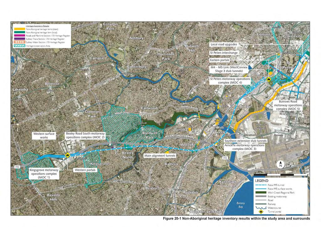
2 20.1 Assessment methodology The methodology for the non-aboriginal heritage assessment included: Identifying the study area relevant to non-aboriginal heritage and the project A literature and database review, including a search of relevant heritage registers and schedules to identify properties within the non-aboriginal heritage study area that may be impacted during construction and operation of the project A field survey of the identified properties within the study area An assessment of heritage significance for the non-aboriginal heritage items that may be impacted by the project, including by locating / updating existing statements of heritage impact and preparing new statements of heritage impact where none previously existed Assessment of the likely level of impact during construction and operation on the identified properties and non-aboriginal heritage items, including preparation of statements of heritage impact Identification of proposed mitigation and management measures, including measures to avoid significant impacts and an evaluation of the effectiveness of the mitigation measures. The non-aboriginal assessment was undertaken in line with following guidelines: The Burra Charter (the Australia ICOMOS charter for places of Cultural Significance) (ICOMOS (Australia), 2013) Assessing Heritage Significance (NSW Heritage Office, 2001) Assessing Significance for Historical Archaeological Sites and Relics (NSW Heritage Branch, 2009) Heritage Curtilages (NSW Heritage Office and NSW Department of Urban Affairs and Planning, 1996b) Levels of Heritage Significance (NSW Heritage Office, 2008). Apart from the abovementioned guidelines, no further components of the NSW Heritage Manual were considered relevant in assessing the potential impacts of the project. Furthermore, as no impacts to the archaeological potential of heritage items would occur as part of the project, it was not considered necessary to prepare a specific archaeological assessment methodology, nor was it considered necessary to prepare for archaeological test excavations in consultation with the Heritage Council of NSW Study area The study area for the non-aboriginal heritage assessment is shown in Figure 20-1, which includes the sub-surface tunnel alignments and all surface works with a 50 metre buffer on both. The 50 metre buffer has been determined as adequate to assess the potential impacts of the project on heritage items Literature and database review A review of archaeological and historical data relevant to the project has been completed, which included heritage registers, databases and schedules, local histories and archaeological reports. This literature and data review was used to identify known non-aboriginal heritage sites located within the study area. WestConnex New M5 20-2
3 A search of the relevant heritage databases was conducted on 13 April 2015 and updated on 1 September 2015 to identify non-aboriginal heritage items within the study area. The following heritage databases have been searched: Statutory databases: World Heritage List (World Heritage Committee, UNESCO) The Commonwealth Heritage List (Australian Heritage Council) The National Heritage List (Australian Heritage Council) The State Heritage Register (NSW Heritage Branch, OEH) The State Heritage Inventory (NSW Heritage Branch, OEH) Section 170 Heritage and Conservation Register compiled by Roads and Maritime Section 170 Heritage and Conservation Register compiled by Sydney Trains Section 170 Heritage and Conservation Register compiled by Transport for NSW Section 170 Heritage and Conservation Register compiled by Sydney Water Section 170 Heritage and Conservation Register compiled by Ausgrid Schedule 5 of the Hurstville Local Environmental Plan 2012 (Hurstville LEP) Schedule 5 of the Canterbury Local Environmental Plan 2012 (Canterbury LEP) Schedule 5 of the Rockdale Local Environmental Plan 2011 (Rockdale LEP) Schedule 5 of the Botany Bay Local Environmental Plan 2013 (Botany Bay LEP) Schedule 5 of the Marrickville Local Environmental Plan 2011 (Marrickville LEP) Schedule 5 of the Sydney Local Environmental Plan 2012 (Sydney LEP), including proposed industrial heritage listings currently under consideration for inclusion in Schedule 5 (City of Sydney, 2014). Non-statutory: The Register of the National Estate (Australian Heritage Council) The Register of the National Trust of Australia (NSW). Other literature was also consulted for relevant information about the non-aboriginal heritage of the study area, including: A review of historical materials, such as historical parish maps and plans, to determine the historical context of the study area and identify any potential for archaeological heritage items Archives from the: National library of Australia State Library of NSW City of Sydney Archives Land and Property Information s on-line Historical Land Records Viewer Trove digitised newspaper collections Relevant local libraries. Non-Aboriginal heritage items and areas identified through searches of these databases and registers are summarised in Table 20-4, Section , and are shown in Figure WestConnex New M5 20-3
4 Field survey Known non-aboriginal heritage items and areas identified as having the potential to be impacted (either directly or indirectly) by the project were subject to a targeted inspection to determine their current condition. Results from these inspections were used to inform an assessment of potential impacts on non-aboriginal heritage values. This process comprised: Review of mapped non-aboriginal heritage listings to identify those properties with the potential to be directly or indirectly impacted during construction or operation of the project Compilation of available information on potentially impacted non-aboriginal heritage listings, including past inspection photographs, as a point of comparison Field inspections of the identified listings, which involved recording the current condition of each site. Each listed item was photographed and compared to past descriptions / photos. Interior features or the condition of the interior of each site, if relevant to the listing, were based on the details provided within the database Field investigation of other potential items of non-aboriginal heritage additional to those recorded listing locations that may be impacted by the project Updates to existing background information with results of field inspections. Field inspections were carried out from 20 to 23 April 2015 and included a pedestrian and vehicle survey from the public domain within the study area. Sites marked on parish plans or identified as part of the survey were inspected and: The structure and / or features identified at each site were recorded The structures / features were then assessed for historical significance Photographs were taken of the structures / features with details maintained in a photo log. An additional day of survey was conducted on 21 May 2015 to inspect the interior of the Rudders Bond Store (53-57 Campbell Road, St Peters) and several heritage listed terraces in St Peters (15, 36, 40, 44, and 126 Campbell Street, St Peters) Significance assessment Assessments of significance were undertaken to determine why particular sites are important and to enable appropriate site management and curtilage to be determined (refer Section ). A heritage item may be significant at a local level (ie to the people living in the vicinity of the item), at a State level (ie to all people living within NSW) or to the country as a whole (National / Commonwealth significance). The significance assessment criteria are provided in Section 3.3 of the Technical working paper: non-aboriginal heritage (Appendix R). Significance assessments were undertaken for all properties identified as listed non-aboriginal heritage items located within the bounds of, or within 50 metres of, the project area. These listed heritage items were assessed for current condition and compared to photographs from past inspections (where available) and the descriptions contained in heritage listings. Statements of significance were sourced from the published listings for these properties Impact assessment For the purpose of the non-aboriginal heritage impact assessment, the potential areas of impact were divided into the following components: The western surface works and Kingsgrove Road surface works The main alignment tunnels The Bexley Road surface works The Arncliffe surface works The St Peters interchange and local road upgrades. WestConnex New M5 20-4
5 More detailed descriptions of activities proposed at each of the areas listed above are provided in Chapter 5 (Project description) and Chapter 6 (Construction work). Impacts on non-aboriginal heritage items have been categorised as follows: Direct where the project would be located within the curtilage of the heritage item and / or involve the demolition or modification of the heritage item Potentially direct where the project may impact on the heritage item subject to the condition of the item, more detailed investigation, construction methodologies and / or the implementation of mitigation and management measures. For example, where the project may impact on the item through construction vibration, settlement, or the application of acoustic treatment Indirect where the project would change the visual context and surroundings of a heritage item. Types of impacts that may result from the construction or operation of the project are identified and described in Table 20-2, and are outlined in more detail below. Table 20-2 Impact Direct Demolition Modification Acquisition Change in heritage conservation area values Potentially direct Acoustic treatment Vibration, settlement and groundwater drawdown from tunnelling works Vibration from surface works Dust Types of impacts to non-aboriginal heritage items Description Demolition of structures. Modification to a heritage item to cater for the project. Impacts resulting from the full or partial acquisition (and associated demolition) of properties that contain heritage items. An example of heritage impact arising from acquisition would be a change from original use. Construction of a new element within a heritage conservation area. Properties, some of which may be listed heritage items, may qualify for atproperty acoustic treatment. This may impact on the fabric or the significance of the heritage item. The area of potential impact for the main alignment tunnels, on ramp and off ramp tunnels includes a zone on the surface equal to a distance of 50 metres from the outer edge of the underground tunnels. The potential impacts on non-aboriginal heritage items may be caused by: Construction vibration from blasting works as the road headers pass underneath properties The settlement of land if tunnelling activities are conducted underneath or close to heritage features Impacts on tree roots, in the case of street trees, depending on the depth of the tunnelling activity. Depending on the setback of buildings from the construction footprint, there is the potential for vibration impacts associated with surface road works, building construction and / or the cut-and-cover sections of the main alignment tunnels, and on and off-ramps. Construction activities may result in the generation of dust where construction works are at the surface or during the handling of spoil. Spoil handling would be in part undertaken inside acoustic sheds at compounds. Air quality impacts during construction would be managed by implementing standard and best practice mitigation measures. As such, this potential impact has not been considered further. For further information on dust management, see Section (Air Quality). WestConnex New M5 20-5
6 Impact Indirect Visual Description There may be temporary and permanent visual impacts as result of the project. These may include: Construction of new road infrastructure or ancillary facilities Alterations to surface roads New noise walls or modifications to existing noise walls, including changes to the height of noise walls Removal of vegetation Establishment and use of construction compounds. For more information see Sections and (Visual impact and urban design). The degree to which the impacts listed above would affect the heritage value or significance of identified non-aboriginal heritage items would vary. In order to undertake a comparative assessment, a set of impact ratings were established and used to rank the degree of impact. These impact ratings are described in Table 20-3 below. Table 20-3 Non-Aboriginal heritage impact criteria Impact Criteria assessment Negligible Impacts to the heritage item in question would be negligible and would not affect the overall heritage significance of the item. Minor impact Minor impacts may occur to the listed item, typically with respect to its reported curtilage as opposed to the listed item itself These impacts would be minimal and would not affect the overall heritage significance of the item Impacts that can be mitigated through remediation and repairs. Significant Impacts to the heritage item are unavoidable with the current project design impact The heritage value of the item would be impacted Existing environment Historical context The literature and data review was used to inform a description of the historical context of the region from pre-european contact until the present day, as follows: Aboriginal history - the study area falls within the traditional country of the Darug people, who spoke the Darug (also spelt Dhaŕ-rook, Dharrook, Dhaŕook, Dharruk and Dharug) language. Individual bands of up to around 60 individuals occupied the Cumberland Plain (Attenbrow, 2010), with much larger groups of Aboriginal people, numbering in the hundreds, coming together for events such as corroborees, ritual combats and feasts Post-contact history - traditional hunting and camping grounds of the Darug-speaking peoples of the Sydney Region were rapidly claimed and settled by Europeans, and Aboriginal populations decimated by introduced diseases such as tuberculosis and small pox (Attenbrow, 2010). Further details regarding the Aboriginal history and heritage of the region can be found in Section 23.2, and Section 4.2 of the Technical working paper: Aboriginal heritage (Appendix R) European settlement: The Cooks River and Wolli Creek area was one of the last areas close to Sydney to be settled by Europeans. From 1799, the land from what is today Tempe and St Peters to the modern suburb of Kingsgrove was settled as pasture and timbered lands (Wolli Creek Preservation Society, 2011). The area known today as Beverly Hills was settled in It contained dense forest, small market gardens, dairies, timber getters and charcoal burners (City of Canterbury Library, 2012). Arncliffe was settled in the 1830s and the land was used for farming, including the raising of pigs, poultry, cattle and horses (Rathborne, 1997) WestConnex New M5 20-6
7 The first large estate in the area was owned by James Chandler who purchased Sylvester Farm in 1822, around 100 acres (about 40 hectares) to the west of Wolli Creek adjoining Kingsgrove which was added to with a further grant of 1,200 acres (about 485 hectares), covering what is today Bexley, Bexley North, Kogarah and part of Rockdale (Rathborne, 1980) The depression of the 1840s plunged many big estate owners into bankruptcy, resulting in subdivision of land along Wolli Creek for smaller farms and market gardens (Wolli Creek Preservation Society, 2011) Early 20th century: Many older houses and mansions in the region were subdivided and replaced by working class housing and industries. Bexley remained an elite suburb, Arncliffe accommodated noxious industries such as tanneries, boiling down works and wool washing, and St Peters was famous for its brickworks (Thorp, 1994) The opening of the East Hills railway line in 1931, as well as the break-up of former private lands. Greater access to cars as a means of transport encouraged significant increase in the region s suburbanisation. However, Bexley North, Kingsgrove and Kyeemagh remained sparsely settled until after World War II (Thorp, 1994). Post World War II: Small farms, dairies and market gardens closed in the 1960s following pressures of increased urbanisation (Wolli Creek Preservation Society, 2011) Incremental development of Sydney Airport took place over time with the addition of new passenger and military infrastructure. Following WWII, Cooks River was diverted to develop new runways. A third runway was opened in 1994, requiring the Commonwealth government to acquire properties in the area. In 2002 the airport was privatised (Sydney Airport Corporation Limited, 2009) In 2001, the Roads and Traffic Authority (now Roads and Maritime) opened the M5 East Motorway to traffic (Roads and Maritime, 2015c). Present day - the study area covers a populous residential and commercial area and supports the main road infrastructure linking the Sydney CBD, Sydney Airport and Port Botany to western Sydney Historic heritage items The review of heritage registers and databases identified 57 individual heritage items within the study area (refer to Table 20-4 and Figure 20-1). Taking in account that seven items are listed on more than one register, a total of 70 listings were identified. Table 20-4 Register Commonwealth World Heritage List National Heritage List Commonwealth Heritage List Register of the National Estate (non-statutory) Nine heritage items. Historic heritage items identified on heritage registers Items within study area No listed items. No listed items. No listed items. Alexandra Canal (ID No ) St Peters Brickpit Geological Site on Princes Highway (ID No ) St Peters Anglican Church and graveyard on Princes Highway 9 ID No 1716) Kingsgrove East Urban Conservation Area (ID No ) Pallamanna Parade Urban Conservation Area (Beverly Hills) (ID No ) Clemton Park Urban Conservation Area (ID No ) Bardwell Park Urban Conservation Area (ID No ) Sydenham Village (ID No ) WestConnex New M5 20-7
8 Register State NSW State Heritage Register Five State listed heritage items Sydney Water Section 170 Heritage And Conservation Register Three State listed heritage items Sydney Trains Section 170 Heritage And Conservation Register One State listed heritage items, and three listed as having local significance Items within study area Arncliffe Railway Station Group on Firth Street (ID No 01076) Western Outfall Main Sewer Valda Avenue (ID No 01647) Timber Slab Cottage on Barden Street (ID No 01412) Alexandra Canal 9 ID No St Peters Anglican Church and graveyard on Princes Highway (ID No 00032) Western Outfall Main Sewer Valda Avenue (ID No ) Alexandra Canal (ID No ) Sewerage Pumping Station No. 39 (ID No ) Arncliffe Railway Station Group on Firth Street (ID No ) Arncliffe Overbridge on Forest Road (ID No ) Bexley North Railway Station (Register ID No ) Wolli Creek Culvert (Register ID No ) Roads and Maritime Section 170 Heritage And Conservation Register Two State heritage items Local Canterbury LEP Hurstville LEP Marrickville LEP Seventeen local heritage items, including one heritage conservation area WestConnex New M5 Terrace group of housing at Campbell Street (ID No ) House at 82 Campbell Street (ID No ) No listed items. No listed items. Timber Slab Cottage on Barden Street (I294) Moreton Bay Fig at 43 South Street (I303) Brick Kerbs and Sandstone Kerb Guttering (George Street, Henry Street, Park Road, Park Lane, Railway Lane, Rowe Lane, Reilly Lane and Stewart Lane) (I284) Victorian Filigree Style Sandstone Faced Residence on Railway Road (I288) Construction of St Mary / St Mina Coptic Orthodox Church on Railway Road (I289). Note that Marrickville Council have determined to demolish the Church. It will be removed from the Marrickville LEP. Alexandra Canal (I270) Goodsell Estate Heritage Conservation Area (C16) Southern Cross Hotel on Princes Highway (I277) A Service Garage at 316 Princes Highway (I312) Westpac Stores and Penfolds Wine Cellars on Princes Highway (I299) St Peters Anglican Church and graveyard on Princes Highway (I275) The Town and Country Hotel on Unwins Bridge Road (I281) Narara Terraces on Unwins Bridge Road (I282) The Waugh and Josephson Industrial Buildings on Unwins Bridge Road (I280) The terrace houses at May Street (I273) St Peters Public School at 93A Church Street (I271) Remaining brick road and footpath paving and stone guttering (I283) 20-8
9 Register Rockdale LEP Twenty-one local heritage items Sydney LEP Eight local heritage items, including two items listed under proposed amendments to Sydney LEP (industrial and warehouse buildings) Botany Bay LEP Items within study area House at 148 Wollongong Road (I61) Victorian Shop and Dwelling on Firth Street (I21) Arncliffe Railway Station Group on Firth Street (I1) Street Plantings on Firth Street (Figs) (I18) Glenevie Lane (I20) Arncliffe Post Office and residence on Firth Street (I19) Victorian Houses and Semi-Detached Dwelling on Stanley Street (16-26) (I48) Victorian Houses and Semi-Detached Dwelling on Stanley Street (16-26) (I49) Victorian Houses and Semi-Detached Dwelling on Stanley Street (16-26) (I50) Victorian Houses and Semi-Detached Dwelling on Stanley Street (16-26) (I51) Rosslyn Hospital on Forest Road (I24) St Francis Xavier Church Group on Forest Road (I22) St Francis Xavier Catholic Presbytery on Forest Road (I23) Victorian house at 73 West Botany Street (I56) Californian Bungalow at 21 Fairview Street (I16) Californian Bungalow at 7 Fairview Street (I15) Bard of Avon Terrace at 39 Eden Street (I13) Victorian house at 31 Kyle Street (I35) Wolli Creek Valley (I237) Stotts Reserve on Slade Road (I165) Stone Federation House at 15 East Street (I81) Alexandra Canal (I13) Warehouse Rudders Bond Store on Campbell Street (I405) The Terrace Group at 2-34 Campbell Road (I12) Sewerage Pumping Station No. 39 (I18) Industrial Building Frank G Spurway on Maddox Street (I20) The Cooper Estate Conservation Area (C2) Macdonaldtown stormwater channel on Euston Road (proposed amendment ID No 3) Former Alexandria Spinning Mills on Maddox Street (proposed amendment ID No and 14) Alexandra Canal (I1) One local listed heritage item Total 70 listings of a total of 57 individual heritage items (including seven heritage items which are listed on two or more registers) Seven items were found to be listed on more than one heritage register (refer to Table 4 of Technical working paper: Non-Aboriginal heritage in Appendix R). In the case of those heritage items with multiple listings, each heritage item has only been counted once. The following areas are broad, landscape based heritage listings: Pallamanna Parade Urban Conservation Area Kingsgrove East Urban Conservation Area Clemton Park Urban Conservation Area Bardwell Park Urban Conservation Area WestConnex New M5 20-9
10 Goodsell Estate Heritage Conservation Area Cooper Estate Conservation Area Sydenham Village. The significance of these areas is discussed further in Section 6.0 of Technical working paper: Non- Aboriginal heritage (Appendix R). While the Former Bedford Brickworks group within Sydney Park is locally listed under the Sydney LEP (I27), it sits outside the 50 metre study area delineated in Section Furthermore, while not listed under the Sydney LEP or any other heritage register, Sydney Park itself does contain areas of archaeological potential pertaining to the former brickworks (refer Sections and of Appendix R). Due to the prominence of these items, they have been considered for potential visual impacts as a result of the project (refer Section of Appendix R). WestConnex New M
11
12 (blank page) WestConnex New M
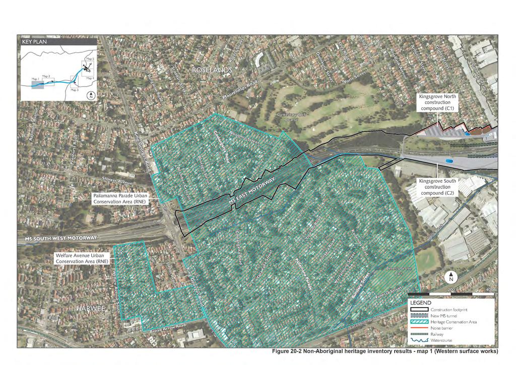
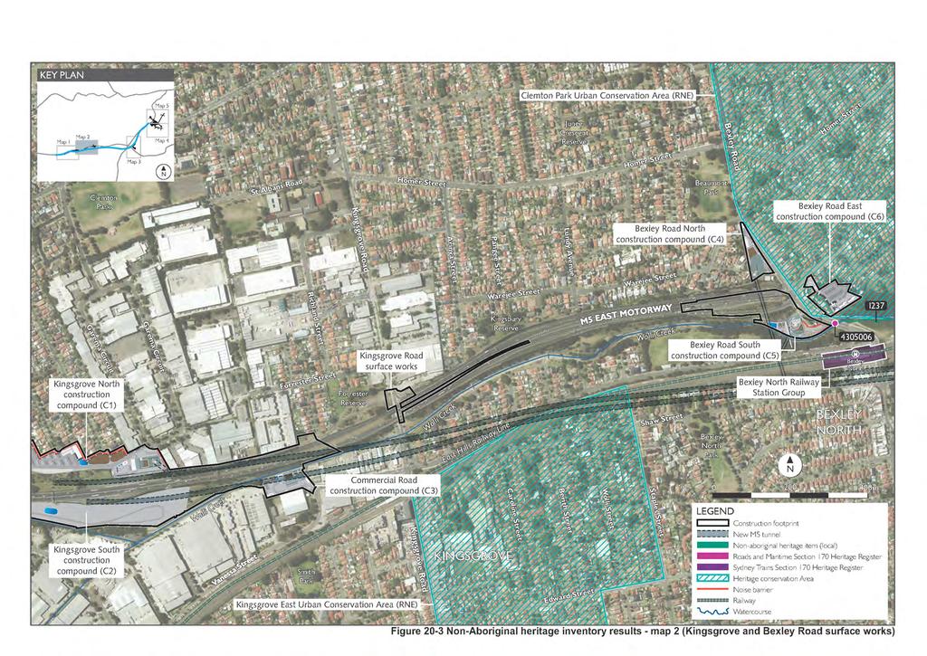
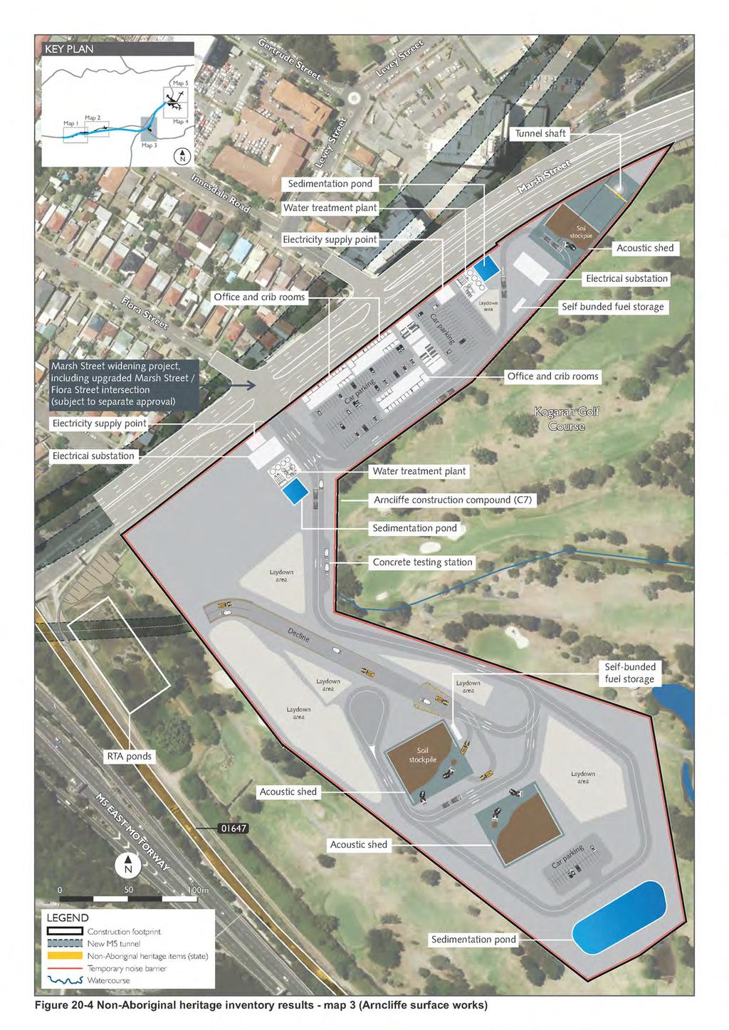
13 Surface disturbance areas The review of historical maps, plans and images focused on areas where surface disturbance is proposed. Archaeological relics or deposits located in the vicinity of the tunnel alignments are unlikely to be impacted by the project, except in areas of surface disturbance as part of the western surface works, the St Peters interchange surface works and intervening construction compound sites. This section is divided into an examination of the non-aboriginal archaeological potential of the western surface works, Bexley surface works, Arncliffe surface works area, St Peters interchange and local roads upgrades, which are shown on Figure 20-2 to Figure It is also relevant to note the potential for historical tram tracks to be intercepted by ground breaking works throughout these areas. Historically, tram tracks extended throughout the Sydney area, including tracks running from the central business district toward Newtown, Alexandria, Enmore, St Peters, Marrickville, Tempe and Cooks River. As the historical retention of tram tracks and associated infrastructure beneath later developments was ad hoc, there is therefore potential to encounter tram tracks wherever those tracks were historically located. Western surface works This area is shown in Figure 20-2 and Figure Historical parish plans and the 1943 aerial photography of Sydney provide evidence of land grants, subdivisions and later residential development in this area. The western surface works would take place within the existing M5 East Motorway road reserve. There is no indication that potential archaeological relics or deposits remain in situ at this location. Kingsgrove Road surface works This area is shown in Figure The Kingsgrove Road surface works would be undertaken within the current road reserve of the M5 East Motorway. There are no identified areas of archaeological potential within the areas likely to be disturbed by the Kingsgrove Road surface works. Bexley Road surface works This area is shown in Figure The Bexley Road surface works (which would include construction and operational ancillary facilities) are located within three discrete locations on the eastern and western side of Bexley Road, north of the Bexley North Railway Station. Parish plans and the 1943 aerial photograph indicate that two of the three locations of the Bexley Road surface works remained undeveloped in 1943 (refer to Figure 8 of Appendix R). Any relics found at these locations would therefore post-date the early 1940s. The Bexley Road east construction compound has been historically occupied by buildings, as shown on Figure 15 of Appendix R. As the site is currently occupied by the M5 East Motorway trial filtration plant, the potential for remnant relics or deposits is considered to be low. Arncliffe surface works area This area is shown in Figure Parish records show that the area around the Arncliffe surface works area was probably still Crown land before the 1830s. The 1943 aerial photographs show that the surrounding area was used for market gardening, and indicate a number of small structures within the extent of the works. However it is anticipated that relics and deposits associated with those structures would have been removed during the subsequent construction of the golf course and associated reclamation activities. St Peters interchange This area is shown in Figure 20-5 and Figure It was initially subject to an early colonial land grant. However the land was swampy and so remained undeveloped for a period. The 1890s parish plan shows Barwon Park, which, according to the 1951 aerial photograph became the Central Brick and Tile Company kilns. Aerial photographs between 1951 and 1997 indicate that the area containing the kilns was used to manage and stockpile wastes and was later disturbed, and that the kilns and associated structures were later demolished. It is unlikely that relics or deposits associated with the Central Brick and Tile Company remain in situ as any remains are likely to have been disturbed by subsequent waste facility related activities. WestConnex New M
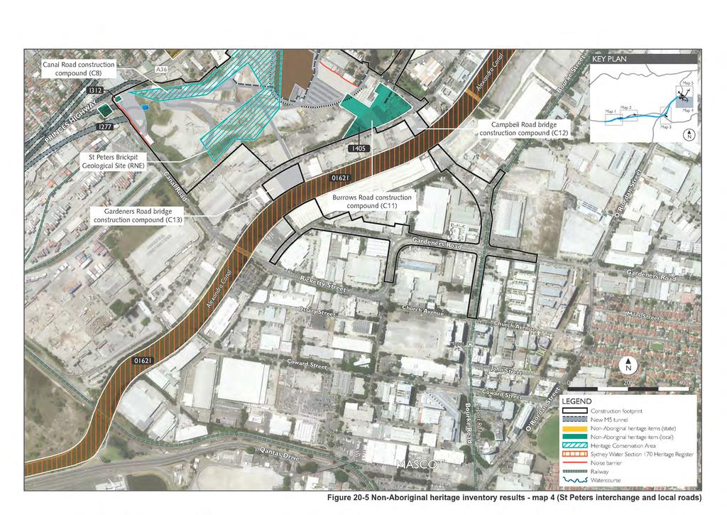
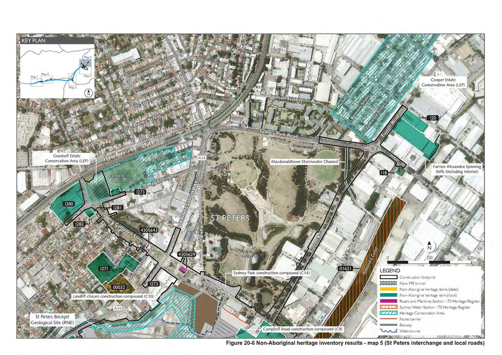
14 The Austral Brick Company also established and operated separate kilns and a brickpit in this area in It is unlikely that relics associated with the Austral Brick Company will remain in these areas, apart from a section on the corner of Princes Highway and Canal Road. No substantial ground disturbance works are planned for this area as it contains the Service Garage at 316 Princes Highway, St Peters (a heritage item that is being retained). The footprint of the heritage item closely mirrors that of an historical building from the Austral operation and it is therefore unlikely that landscaping works or similar around the heritage item would encounter relics. Local road upgrades These areas are shown in Figure 20-5 and Figure The local roads upgrades would be largely undertaken within current road reserves and associated footpaths or in industrial areas that have been developed recently. However, some local road upgrade works would encroach onto numerous areas containing non-aboriginal heritage items, including the following: Goodsell Estate Heritage Conservation Area, corner of Bedwin Road and May Street, St Peters Roads and Maritime owned terrace housing, Campbell Street, St Peters Roads and Maritime owned house, Campbell Street, St Peters Alexandra Canal Cooper Estate Heritage Conservation Area, bounded by Fountain Street, Lawrence Street, Hartley Street, Lawrence Lane, Huntley Street and Mitchell Road, Alexandria St Peters Brickpit Geological site, corner of Princes Highway and Canal Road. WestConnex New M
15
16 (blank page) WestConnex New M
17
18 (blank page) WestConnex New M
19
20 (blank page) WestConnex New M
21
22 (blank page) WestConnex New M
23
24 (blank page) WestConnex New M
25 Significance assessment To understand how the project would impact on non-aboriginal heritage items within the study area it is necessary to first understand why each non-aboriginal heritage item is significant. Assessments of significance explain why a particular heritage item is important. They also enable the boundary of the heritage site to be properly identified, and allow appropriate site management measures to be selected. For many of the non-aboriginal heritage items within the study area, statements of heritage significance already exist and are available in the public domain. Where necessary, and based on the site inspection and historical research carried out, significance assessments were revised to ensure they were up to date. Non-Aboriginal heritage items may be classified as having either a local or State level of heritage significance, in accordance with the guideline Assessing Heritage Significance (NSW Heritage Office, 2001) and the Heritage Act Full details of the methodology used to assess non-aboriginal heritage significance are provided in Section 3.0 of the Technical working paper: Non-Aboriginal heritage (Appendix R). The resulting statements of significance for each non-aboriginal heritage item within the study area are provided in Section 6.0 of the Technical working paper: Non-Aboriginal heritage (Appendix R). Table 20-5 summarises the significance of individual non-aboriginal heritage items found within each suburb of the study area. The locations of these non-aboriginal heritage items along the study area are shown in Figure The Register of the National Estate no longer has a statutory purpose. Indicative places were identified as potentially being eligible for listing on the Register, but their boundaries and heritage significance were not subject to further refinement. WestConnex New M
26 Table 20-5 Significance listing and reasons for heritage significance Significance / listing Kingsgrove / Beverly Hills / Clemton Park Register of the National Estate ID No Register of the National Estate ID No Register of the National Estate ID No Bexley North Local significance - Sydney Trains Section 170 Heritage and Conservation Register ID No Summary of heritage significance The Kingsgrove East Urban Conservation Area (Kingsgrove) is identified on the Register of the National Estate as an area of 1930s Californian bungalows, with some 1940s and 1950s houses. Its status is as an indicative place. The Pallamanna Parade Urban Conservation Area (Beverly Hills) is identified on the Register of the National Estate as an area of 1930s Californian bungalows, with some 1940s and 1950s houses. Its status is as an indicative place. The Clemton Park Urban Conservation Area (Clemton Park) is identified on the Register of the National Estate as an area of 1930s Californian bungalows, with some 1940s and 1950s houses. Its status is as an indicative place. While not rare, the Bexley North Railway Station is part of the East Hills line, a major Great Depression period piece of public works infrastructure. It provides examples of experimentations with railway architectural styles adaptation to depression period economic conditions. Local significance Rockdale LEP I165 Stotts Reserve on Slade Road is a sandstone vegetation and forested area containing remnant bushland. Bardwell Park Local significance Rockdale LEP I81 Stone Federation House at 15 East Street is a federation rusticated sandstone cottage from the 1910 Maylands Estate subdivision. Register of the National Estate ID No Bardwell Park Urban Conservation Area is an area of 1930s Californian bungalows, with some 1940s and 1950s houses. Earlwood Roads and Maritime Section 170 Heritage and Conservation Register ID No Arncliffe Local significance - Rockdale LEP I61 Local significance - Rockdale LEP I21 State significance State Heritage Register ID No 01076, Sydney Trains Section 170 Heritage and Conservation Register ID No , and Rockdale LEP I1 Wolli Creek Culvert on Bexley Road was a key component of upgrade works bringing Bexley Road up to standard as a newly classified Main Road serving fast growing Canterbury. House at 148 Wollongong Road is a single storey federation arts and crafts style. Victorian Shop and Dwelling on Firth Street evidences the district s economic growth in the mid-late 19th century (ie used as a grocery shop servicing growing population accompanying improved railway access). It also evidences strip commercial development in the Rockdale local government area in the early 20th century. Arncliffe Railway Station Group on Firth Street demonstrates the Illawarra Line s development from 1884 to WestConnex New M
27 Significance / listing Local significance - Rockdale LEP I18 Local significance - Rockdale LEP I20 Local significance Register of the National Estate ID No 19170, and Rockdale LEP I19 Local significance - Rockdale LEP I48 Local significance - Rockdale LEP I49 Local significance - Rockdale LEP I50 Local significance - Rockdale LEP I51 Local significance - Sydney Trains Section 170 Heritage and Conservation Register ID No Local significance - Rockdale LEP I24 Summary of heritage significance Street Plantings on Firth Street (Figs) evidence the public streets beautification program in the early 20th century. Glenevie Lane connects an urban network of streets between Firth Street and the Arncliffe Railway Station. Arncliffe Post Office and residence on Firth Street are of rare federation style. Victorian Houses and Semi-Detached Dwelling on Stanley Street (16-26) are part of rare group from the early development of Bardens Estate in Victorian Houses and Semi-Detached Dwelling on Stanley Street (16-26) are part of rare group from the early development of Bardens Estate in Victorian Houses and Semi-Detached Dwelling on Stanley Street (16-26) are part of rare group from the early development of Bardens Estate in Victorian Houses and Semi-Detached Dwelling on Stanley Street (16-26) are part of rare group from the early development of Bardens Estate in Arncliffe Overbridge on Forest Road is the largest single span brick arch road bridge on the NSW railway network. Rosslyn Hospital on Forest Road is a prominent Victorian style villa. Its later conversion to a hospital was a significant contribution to health services development in Arncliffe. Local significance - Rockdale LEP I22 St Francis Xavier Church Group on Forest Road shows ecclesiastical design from the interwar period, and is historically significant to the early 20th century development of Arncliffe. Local significance - Rockdale LEP I23 St Francis Xavier Catholic Presbytery on Forest Road is a late Victorian villa. Local significance - Rockdale LEP I56 Victorian house at 73 West Botany Street is part of the original village of West Botany. Local significance Rockdale LEP I16 Californian Bungalow at 21 Fairview Street is part of the original Gibbini Dappeto Estate subdivision in 1918, as Rockdale developed into a commuter suburb. Local significance - Rockdale LEP I15 Californian Bungalow at 7 Fairview Street demonstrates the expansion of Arncliffe during the 1920s- 1930s. State significance State Heritage Register ID Western Outfall Main Sewer continues in use as part of an original system built in the 1890s to end No 01647, Sydney Water Section 170 Heritage sewage discharge to Sydney Harbour. and Conservation Register ID No Local significance Rockdale LEP I13 Local significance - Rockdale LEP I35 Bard of Avon Terrace at 39 Eden Street is early evidence of the Wincanton Estate and the late 19th century development of Arncliffe. Victorian house at 31 Kyle Street was one of the first houses built on the Innesdale Estate. WestConnex New M
28 Significance / listing Wolli Creek Local significance - Rockdale LEP I237 Tempe State significance State Heritage Register ID No 01412, and Marrickville LEP I294 Local significance Marrickville LEP I303 Sydenham Local significance - Marrickville LEP I284 Local significance - Marrickville LEP I288 Local Significance - Marrickville LEP I289 Register of the National Estate ID No St Peters State significance Register of the National Estate ID No , State Heritage Register ID No 01621, Sydney Water Section 170 Heritage and Conservation Register ID No , Sydney LEP I13, Marrickville LEP I270 and Botany Bay LEP I1 Summary of heritage significance Wolli Creek Valley is a rare example of native vegetation and landscape in the inner Sydney urban area, containing several rare and significant fauna and flora species. It is significant for its role in the decision to begin settlement in the area by providing water and promised good soils for crops. It was integral to the protection of the riparian corridor of Wolli Creek and acts as an essential green recreation corridor buffering densely urban surrounding areas. Timber Slab Cottage on Barden Street was constructed around 1840, and is a rare surviving example of rudimentary timber buildings in early Sydney. Moreton Bay Fig at 43 South Street was planted after the Tempe Estate subdivision, in either late 19th or early 20th century. Brick Kerbs and Sandstone Kerb Guttering (George Street, Henry Street, Park Road, Park Lane, Railway Lane, Rowe Lane, Reilly Lane and Stewart Lane) demonstrate the development of Sydenham. These are rare heritage features, given that the majority of guttering is now impacted / replaced by upgrade works. Victorian Filigree Style Sandstone Faced Residence on Railway Road has an unusual stone front façade reflecting proximity to stone quarries. Construction of St Mary / St Mina Coptic Orthodox Church on Railway Road demonstrated the district s growing Methodist congregation. It is noted that Marrickville Council has determined to demolish the Church as no suitable use for the structure has been found. Sydenham Village is listed on the Register of the National Estate as an indicative place. It was an area of workers cottages, built with bricks from the local brickworks. The central portion of the village was demolished as noise mitigation related to the construction of the third runway at Sydney Airport. Alexandra Canal was built on the historic Sheas Creek, which was first dredged in 1887, and was an unemployment relief scheme. The original canal extended between Sydenham to Botany Railway Bridge to the Canal Road Bridge. In 1894 plans were made to extend the Canal to Redfern. However, only part of this was constructed and the Canal halted just to the south of Huntley Street, Alexandria in During the expansion of Sydney Airport between 1947 and 1970, the Canal underwent major alterations. However the Canal was never fully utilised, being subject to silting, tidal factors and limitations on the draft of vessels that could use the passage. The closure of the Canal to shipping traffic began in the 1930s when two lifting span bridges were replaced with fixed span bridges. In the early 1940s the wharves that had serviced the Alexandra Canal were demolished as the declining use of the Canal did not warrant their maintenance. WestConnex New M
29 Significance / listing Local significance - Marrickville LEP C16 Local significance Roads and Maritime Section 170 Heritage and Conservation Register ID No Local significance Roads and Maritime Section 170 Heritage and Conservation Register ID No State significance - Sydney LEP I405 Local significance - Sydney LEP I12 Register of the National Estate ID No Local significance - Marrickville LEP I277 Local significance - Marrickville LEP I312 Local significance - Marrickville LEP I299 State significance State Heritage Register ID No 00032, the Marrickville LEP 2011 I275, and Register of the National Estate ID No Local significance - Marrickville LEP I281 Local significance - Marrickville LEP I282 Local significance - Marrickville LEP I280 Local significance - Marrickville LEP I273 Local significance - Marrickville LEP I271 Summary of heritage significance Goodsell Estate Heritage Conservation Area demonstrates principles and patterns of Marrickville's development, including brick and pottery industries. Terrace group of housing at Campbell Street is part of rare group housing for this part of Sydney prior to the 1890s. These properties housed brickworkers after the 1870s. House at 82 Campbell Street is part of rare group housing for this part of Sydney prior to the 1890s. These properties houses brickworkers after the 1870s. Warehouse Rudders Bond Store on Campbell Street is of State historical significance through its associations with Ralph Symonds Pty Ltd. The Symonds company were instrumental in the development and wide-spread use of glued structural laminated timber and laminated timber more generally, particularly during the materials shortages of World War Two and the following years. The Terrace Group at 2-34 Campbell Road was constructed around 1886 and leased to families working in nearby brickpits and factories. St Peters Brickpit Geological Site on Princes Highway has palaeontological value, and has been used for tertiary Palaeontological / geological educational purposes. Southern Cross Hotel on Princes Highway has been a hotel site since The existing 1936 hotel shows interwar free classical style. A Service Garage at 316 Princes Highway has detailing and architectural style unusual as applied to a mechanical workshop. Westpac Stores and Penfolds Wine Cellars on Princes Highway were constructed in 1956, and constitute a modern industrial precinct of better quality than many of the other recent industrial developments in the area. St Peters Anglican Church and graveyard on Princes Highway is one of the earliest churches constructed as a result of the Church Building Act 1836 and with the use of free labour in NSW. The graveyard contains many colonial settlers. The Town and Country Hotel on Unwins Bridge Road is unusual for its close historical association with the Narara Terraces, and by together forming a unifying corner treatment of Unwins Bridge Road. Narara Terraces on Unwins Bridge Road are unusual for their close historical association with the Town and Country Hotel, and by together forming a unifying corner treatment of Unwins Bridge Road. The Waugh and Josephson Industrial Buildings on Unwins Bridge Road show the interwar functionalist style of the area. The terrace houses at May Street provided accommodation for brick and other industrial workers. St Peters Public School at 93A Church Street is a late 19th century school building showing the development of St Peters. WestConnex New M
30 Significance / listing Local significance Marrickville LEP I283 Alexandria Local significance Sydney Water Section 170 Heritage and Conservation Register ID No Local significance - Sydney LEP I18 Local significance - Sydney LEP I20 Local significance Sydney LEP C2 Local significance - proposed amendment to Sydney LEP 2012 (Industrial and warehouse buildings) ID No 3 Local significance - proposed amendment to Sydney LEP 2012 (Industrial and warehouse buildings) ID No and 14 Summary of heritage significance Remaining brick road and footpath paving and stone guttering. Sewerage Pumping Station No. 39 has multiple heritage listings. It and Water Board Pump House on Huntley Street were constructed in 1925 to combat the increasing pollution caused by Sydney s growing population. Industrial Building Frank G Spurway on Maddox Street shows mid-20th century industrial / commercial development. The Cooper Estate Conservation Area was subdivided in the 1880s to provide housing for industrial workers. Macdonaldtown stormwater channel on Euston Road is proposed to be included in amendments to Sydney LEP. Former Alexandria Spinning Mills on Maddox Street is proposed to be included in amendments to Sydney LEP. WestConnex New M
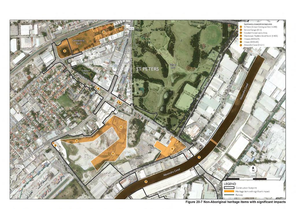
31 20.3 Assessment of potential impacts Fifty seven non-aboriginal heritage items are expected to be directly or indirectly impacted by the project. In some instances, an item would be both directly and indirectly impacted by the project. The early identification of non-aboriginal heritage items and conservation areas during the design phase informed the project design and enabled the avoidance of heritage items where practicable. Impacts to heritage items are discussed below. Statements of heritage impact are included in Section 9.0 of the Technical working paper: Non-Aboriginal heritage (Appendix R). The assessment considered the following types of impacts: Primary direct impacts, where the project would be located within the curtilage of the heritage item and / or involve the demolition or modification of the heritage item or its heritage significance Secondary direct impacts to heritage items, where the project may impact on the heritage item or its significance subject to the condition of the item, more detailed investigation, construction methodologies and / or the implementation of mitigation and management measures Indirect impacts to heritage items, where the project would change the visual context and surroundings of a heritage item with the potential to affect its heritage significance. The assessment considered the degree of impact the project would have on heritage items (being negligible, minor or significant) (refer Section ). The outcomes of this assessment are presented in Sections 7.0 and 9.0 of the Technical working paper: Non-Aboriginal heritage (Appendix R). Items where the degree of impacts has been determined as minor or significant are provided in Table As an outcome of this assessment, statements of heritage impact have been prepared for the following items which would be considered to be significantly or physically impacted by acquisition by the project following mitigation and management: Rudders Bond Store Terraces and houses on Campbell Street Alexandra Canal St Peters Brickpit Geological Site Service garage Goodsell Heritage Conservation Area. These statements of heritage impact are summarised in Section below. Impacts to the remaining items consist primarily of potential negligible direct impacts as a result of tunnelling works. Further information regarding impacts to non-aboriginal heritage items is provided in Sections 7.0 and 9.0 of the Technical working paper: non-aboriginal heritage (Appendix R), including descriptions of impacts specific to each heritage item. Those heritage items which would be significantly impacted have been assessed further in Section 9.0 of the Technical working paper: Non-Aboriginal heritage (Appendix R), and are depicted in Figure WestConnex New M
32 Table 20-6 LEP and / or other register Summary of impact assessment Item Impact type Comment Degree of impact Section Wolli Creek Vibration from This item is located within ten to 20 metres of the construction footprint Minor secondary Roads and Culvert surface works and has the potential to be directly impacted due to vibration impacts direct impact Maritime # associated with surface construction. However surface works would adhere to safe working distances. vibration (surface works) An existing condition survey report and program of monitoring would be undertaken to identify early potential risks to the heritage item. State Heritage Register Sydney LEP 2012 Marrickville LEP Botany Bay LEP Register of National Estate Section 170 Sydney Alexandra Canal SHR #01621 I3 (Sydney LEP) I270 (Marrickville LEP) I1 (Botany LEP) RNE # Modification Visual Vibration (surface works) Three new bridges would be constructed across Alexandra Canal. This has the potential to generate the following impacts on the heritage values of the Canal: Visual, due to the introduction of three new bridges, including two road bridges and one dedicated pedestrian / cyclist bridge Changes to the navigability of the Canal Direct modification to the embankment, to enable new surface water discharge points and scour protection Vibration, due to surface works occurring in close proximity to the embankments of the Canal. An existing condition survey report and program of monitoring would be undertaken to identify early potential risks to the heritage item. Significant direct impact modification Significant indirect impact visual Significant direct impact vibration (surface works) Water Heritage and Conservation Register WestConnex New M
33 LEP and / or other register Marrickville LEP 2011 Marrickville LEP 2011 Marrickville LEP 2011 Item Impact type Comment Degree of impact St Peters Public School, including interiors I271 Terrace housing, including interiors I273 Waugh and Josephson industrial buildings, former, showroom, offices and workshops, including interiors I280 Vibration (surface works) At-property acoustic treatment Vibration (surface works) Visual Visual Vibration (surface works) The eastern curtilage of the heritage item is located around 50 metres from the construction footprint and has the potential to be directly impacted due to vibration impacts associated with surface construction. However surface works would adhere to safe working distances. An existing condition survey report and program of monitoring would be undertaken to identify early potential risks to the heritage item. The properties have also been identified for consideration of at property acoustic treatment, which would be confirmed during detailed design. The item would be directly located to surface works associated with the local road works, and would have minor impacts to the visual setting of the heritage item. The item also has the potential to be directly impacted due to vibration impacts associated with surface construction. However surface works would adhere to safe working distances. An existing condition survey report and a program of monitoring would be undertaken to identify early potential risks to the heritage item. The item would be directly located at surface works associated with the local road works. However, at this location, the Campbell Road / Unwins Bridge Road and May Street intersection would be realigned to provide greater setback from the heritage curtilage from its eastern boundary. Widening of Unwins Bridge Road at the intersection, however, would result in a minor reduction in setback from its southern boundary. However, the building would retain its landmark qualities, as no part of it would be obscured by the works. Construction works also have the potential to directly impact due to vibration associated with surface construction. However surface works would adhere to safe working distances. An existing condition survey report and program of monitoring would be undertaken to identify early potential risks to the heritage item. Negligible secondary direct impact Vibration (surface works) Minor direct impacts At-property acoustic treatment Potential minor direct impact vibration (surface works) Minor indirect impact visual Potential minor direct impact vibration (surface works) Minor indirect impact visual WestConnex New M
34 LEP and / or other register Marrickville LEP 2011 Item Impact type Comment Degree of impact Town and Country Hotel, including interiors I281 Visual Vibration (surface works) Surface works associated with the local road works would be undertaken directly adjacent to the heritage item. However, at this location, the realignment of the Campbell Road / Unwins Bridge Road / Bedwin Road / May Street intersection would be realigned to provide greater setback of the building from the road carriageways. As such, the project would not have a significant impact on the visual context of the heritage item in terms of its landmark qualities. Potential minor direct impact vibration (surface works) Minor indirect impact visual Construction works also have the potential to directly impact due to vibration associated with surface construction. However surface works would adhere to safe working distances. An existing condition survey report and program of monitoring would be undertaken to identify early potential risks to the heritage item. The item would be directly located at surface works associated with local road works, and would have minor impacts due to the visual setting. Marrickville LEP 2011 Group of Victorian Filigree and Victorian Italianate terrace houses Narara, including interiors. I282 Vibration (surface works) Visual Construction works also have the potential to directly impact due to vibration associated with surface construction. However surface works would adhere to safe working distances. An existing survey condition report and program of monitoring would be undertaken to identify early potential risks to the heritage item. Potential minor direct impact vibration (surface works) Minor indirect impact visual WestConnex New M
35 LEP and / or other register Marrickville LEP 2011 Item Impact type Comment Degree of impact Service Garage I312 Vibration and settlement (tunnelling) Vibration (surface works) Visual impacts The heritage item would be located within the construction footprint, and directly above the eastern portal. Potential impacts may include: Settlement during and after construction. However this would be less than ten millimetres, which is considered to be cosmetic only Vibration impacts during tunnelling Change in use and visual impacts associated within the integration of this item within the urban design of the interchange. Secondary direct minor impact vibration and settlement (tunnelling) and vibration (surface works) Acquisition An existing condition survey report and program of monitoring would be undertaken to identify early potential risks to the heritage item. Significant direct impact acquisition Minor indirect impact visual impacts WestConnex New M
36 LEP and / or other register Marrickville LEP 2011 Item Impact type Comment Degree of impact Goodsell Estate Heritage Conservation area C16 Acquisition Modification Change in heritage conservation area values Visual An area of Camdenville Park, which is located within the Godsell Conservation Area would be directly impacted by the project as a result of: The realignment of the Campbell Road / Unwins Bridge Road / Bedwin Road / May Street intersection. This would result in the permanent loss of an area along the western extent of the conservation area Construction activities associated with the augmentation of the stormwater detention basin for additional flood storage and surface water treatment These have the potential to generate the following impacts on the heritage values of the conservation area: Impacts to heritage values within the conservation area, which would be localised to the western curtilage of the conservation area Visual, due to the realignment and widening of roads, and alterations to the existing stormwater detention basin which is vegetated. However, proposed landscaping would minimise the potential for adverse impacts Direct acquisition of land within the curtilage of the conservation area, resulting in the permanent loss of this portion of land Modification to areas within the conservation area associated with the upgrade of the stormwater detention basin. This would result in excavation of the basin of around two metres from the current level. Minor secondary direct impact vibration (surface works) Minor direct impact acquisition and modification Minor indirect impact visual Minor indirect impact conservation area values Surface road works would also occur within or adjacent to the conservation area, which have the potential to cause vibration impacts on structures within the conservation area. However surface works would adhere to safe working distances. An existing condition survey report and program of monitoring would be undertaken to identify early potential risks to relevant structures within the conservation area and within 50 metres of the main alignment tunnels. WestConnex New M
37 LEP and / or other register Register of National Estate Roads and Maritime Heritage and Conservation Register Roads and Maritime Heritage and Conservation Register Item Impact type Comment Degree of impact St Peters Brickpit Geological Site RNE #16240 Terrace group Campbell Street # House # Modification Visual impacts Vibration (surface works) Demolition Demolition The heritage item would be directly impacted as a result of the St Peters interchange and the construction of a shared pathway along the northern boundary of the St Peters interchange. The project would involve the demolition of this item to enable the widening of Campbell Street. This impact cannot be avoided. The project would involve the demolition of this item to enable the widening of Campbell Road. This impact cannot be avoided. Significant direct impact modification Significant indirect impact visual Significant secondary direct impact vibration (surface works) Significant direct impact demolition Significant direct impact demolition WestConnex New M
38 LEP and / or other register Sydney LEP 2012 Item Impact type Comment Degree of impact Terrace group I12 Visual Vibration (surface works) At-property acoustic treatment The item is located directly adjacent to the surface works associated with the widening of Campbell Road and opposite the St Peters interchange. A new pedestrian bridge would also be constructed to the north-west of the heritage curtilage. Construction compounds would be located in the vicinity of the heritage item. Permanent structures and the road widening would change the visual setting of this heritage item. Construction works also have the potential to directly impact due to vibration associated with surface construction. However surface works would adhere to safe working distances. Minor secondary direct impact vibration (surface works) Minor indirect impact visual Minor direct Atproperty acoustic treatment An existing condition survey report and program of monitoring would be undertaken to identify early potential risks to the heritage item. The properties have also been identified for consideration of at property acoustic treatment, which would be confirmed during detailed design. Surface works associated with the local road works would occur in proximity to the heritage item. However, works associated with the Sydney LEP 2012 Water Board pump house, Visual Minor secondary direct impact Sydney Water including Interior Vibration project would be within an existing road corridor. As such, there would vibration (surface Section 170 and (surface works) be no significant change to the visual setting of the heritage item. works) substructure I18 # There is the potential for the item to be directly impacted due to vibration impacts associated with surface construction. However surface works would adhere to safe working distances. An existing condition survey report and program of monitoring would be undertaken to identify early potential risks to the heritage item. Minor indirect impact visual WestConnex New M
39 LEP and / or other register Sydney LEP 2012 Item Impact type Comment Degree of impact Industrial Building, Frank G Spurway I20 Visual Vibration (surface works) Surface works associated with the local road works would occur in proximity to the heritage item. However, works associated with the project would be within an existing road corridor. As such, there would be no significant change to the visual setting of the heritage item. Minor secondary direct impact vibration (surface works) There is the potential for the item to be directly impacted due to vibration impacts associated with surface construction. However surface works would adhere to safe working distances. An existing condition survey report and program of monitoring would be undertaken to identify early potential risks to the heritage item. The project would involve the demolition of this item. This impact cannot be avoided. Minor indirect impact visual Sydney LEP 2012 Proposed amendment to Sydney LEP 2012 (Industrial and warehouse buildings) Warehouse 'Rudders Bond Store' I1405 Macdonaldtown Stormwater Channel #3 Demolition Visual Vibration (surface works) Surface works associated with the local road works would occur within the curtilage of the stormwater canal, which presently passes under Euston Road. The project would require the widening of Euston Road, which would involve additional sections of the canal being covered. The works would not require a direct modification of the canal structure, but would cause direct impacts as a result of: Change to the visual setting of the item Impacts from vibration impacts associated with surface construction. However surface works would adhere to safe working distances. Significant direct impact demolition Minor secondary direct impact vibration (surface works) Minor indirect impact visual An existing condition survey report and program of monitoring would be undertaken to identify early potential risks to the heritage item. WestConnex New M
40 LEP and / or other register Proposed amendment to Sydney LEP 2012 (Industrial and warehouse buildings) Item Impact type Comment Degree of impact Former Alexandria Spinning Mills #14 Visual Vibration (surface works) Surface works associated with the local road works would occur in proximity to the heritage item. However, works associated with the project would be within an existing road corridor. As such, there would be no significant change to the visual setting of the heritage item. There is potential for the item to be directly impacted due to vibration impacts associated with surface construction. However surface works would adhere to safe working distances. Minor secondary direct impact vibration (surface works) Negligible indirect impact visual An existing condition survey report and program of monitoring would be undertaken to identify early potential risks to the heritage item. WestConnex New M
41 LEP and / or other register Register of the National Estate Item Impact type Comment Degree of impact Clemton Park Urban Conservation Area # Changes in heritage conservation area values Vibration from surface works Visual Impacts to heritage values within the conservation area would be localised to specific areas already associated with major transport network infrastructure, or which have been previously disturbed by previous road infrastructure projects (such as the M5 East Motorway, and the M5 East Motorway filtration trial). Visual impacts due to Bexley Road South motorway operations complex would be visible and may affect certain properties. Temporary visual impacts may also occur while the Bexley Road North construction compound (C4), the Bexley Road South construction compound (C5) and the Bexley Road East construction compound (C6) are used during construction. Negligible direct impact change in heritage values Negligible impact visual Minor secondary direct impact vibration (surface works) However, there would be no direct impacts in the sense that there would be no demolition of houses or structures in the urban conservation area. The works within the urban conservation area are restricted to the current motorway road reserve, land used to support the M5 East Motorway or vacant land. Buildings that are within 50 metres of the construction footprint have the potential to be directly impacted due to vibration impacts associated with surface construction. However surface works would adhere to safe working distances. An existing condition survey report and program of monitoring would be undertaken to identify early potential risks to relevant structures within the conservation area. Landscaping would provide screening of the Bexley Road South motorway operations complex from the Clemton Park Urban Conservation Area, once established. WestConnex New M
42 LEP and / or other register Register of the National Estate Item Impact type Comment Degree of impact Pallamanna Parade Urban Conservation Area # Change in heritage conservation values Vibration from surface works Visual The preferred project corridor at this location follows the existing motorway alignment and passes through the conservation area. The curtilage of this urban conservation area was determined prior to the construction of the M5 East Motorway and has not been updated since. Impacts to heritage values within the conservation area would be localised to specific areas already associated with major transport network infrastructure. The M5 East Motorway would be widened to cater for the western portal and associated ancillary facilities. This would extend into the heritage conservation area. Visual impacts due to changes from new noise walls and the Kingsgrove motorway operations complex which would be visible above the noise walls may affect certain properties. Negligible direct impact change in heritage values Low to negligible indirect impact visual Negligible secondary direct impact vibration (surface works) However, there would be no direct impacts in the sense that there would be no demolition of houses or structures in the urban conservation area. Landscaping would provide screening of the project from the heritage conservation area, once established. For these reasons, visual impacts would be low to negligible. Buildings that are within 50 metres of the construction footprint have the potential to be directly impacted due to vibration impacts associated with surface construction. However surface works would adhere to safe working distances. An existing condition survey report and program of monitoring would be undertaken to identify early potential risks to relevant structures within the heritage conservation area that are within safe working distances. Temporary visual impacts may also occur when the Kingsgrove North construction compound (C1), the Kingsgrove South construction compound (C2) and the Commercial Road construction compound (C3) are used during construction. WestConnex New M
43 Direct impacts There are 57 non-aboriginal heritage items outlined in Table 20-5 which would be directly or indirectly impacted by the project. Of these: Three items would be demolished as a result of the project: Warehouse Rudders Bond Store (ID No I1405 under the Sydney LEP) Terrace group Campbell Street, St Peters (ID No under the Roads and Maritime Section 170 Heritage and Conservation Register) House 82 Campbell Street, St Peters (ID No under the Roads and Maritime Section 170 Heritage and Conservation Register) Modifications ranging from a minor to significant level would be required at four items, being: Alexandra Canal (ID No under the Register of the National Estate, ID No under the State Heritage Register, ID No under the Sydney Water Section 170 Heritage and Conservation Register, ID No I13 under the Sydney LEP, ID No I1 under the Botany LEP 2013, ID No I270 under the Marrickville LEP 2011) St Peters Brickpit Geological Site (RNE #16240) Service Garage 316 Princes Highway (Marrickville LEP 2011 I312) (the modification includes change of use, as a result of acquisition of the property) Goodsell Estate Conservation Area (Marrickville LEP 2011 C16). Eight heritage conservation areas would be partially and directly impacted, with the majority of heritage conservation areas being exposed to negligible impacts only. Landscaping of the project within these areas would minimise the potential impacts. Some of these conservation areas may be impacted by secondary direct impacts (as the tunnel passes under these heritage conservation areas). The overall heritage value of the heritage conservation areas would not be significantly impacted by the project. The three heritage conservation areas that would be partially and directly impacted within the minor to low range of impact are: Pallamanna Parade Urban Conservation Area (ID No under the Register of the National Estate) Clemton Park Urban Conservation Area (ID No under the Register of the National Estate) Goodsell Conservation Area (ID No C16 under the Marrickville LEP). Relevant mitigation measures for these three heritage conservation areas are contained in Table Twenty three items would be directly impacted due to construction vibration from surface works. These impacts are anticipated to have a negligible to minor risk of affecting the significance of the heritage items. Structural damage vibration limits for non-aboriginal heritage properties and recommended safe working distances for vibration intensive plant are provided in Section of the Technical working paper: non-aboriginal heritage (Appendix R). The overall heritage value of these heritage items would not be significantly impacted by the project. Thirty four items would be directly impacted due to vibration, settlement and groundwater drawdown as a result of tunnelling works. These items are primarily located within the preferred project corridor and include items consisting of mainly residential houses. Impacts to these items are anticipated to be minor to negligible. Four of these items would also be directly impacted by construction vibration due to surface works. The overall heritage value of the heritage items would not be significantly impacted by the project. WestConnex New M
44 There is also the potential for direct impacts due to potential eligibility for at-property acoustic treatment. Two of the 57 items have also been identified as being potentially eligible for consideration of property acoustic treatment (St Peters Public School, and the terrace group of housing at 2-34 Campbell Road, St Peters). This would be confirmed during detailed design, in consultation with landowners, and with consideration of potential impacts to heritage values. Treatment would be sympathetic to the heritage values of each item and would be undertaken in accordance with the Burra Charter, which stipulates that changes reducing cultural significance should be reversible. Further information about mitigation measures to manage noise and vibration impacts as a result of the project is provided in Section WestConnex New M
45
13 Land use and property
 13 Land use and property This chapter assesses land use and property impacts associated with the project. The assessment includes: Identification of the local land uses, existing access arrangements and
Stage 2: WestConnex M5 King Georges Road Interchange Upgrade. Appendix B5 Construction Heritage Management Plan
 Stage 2: WestConnex M5 King Georges Road Interchange Upgrade Appendix B5 Construction Heritage Management Plan JULY 2016 DOCUMENT CONTROL File name Report name CEMP App B5 CHMP Rev E Revision number E
(blank page) WestConnex New M Roads and Maritime Services Environmental impact statement
 WestConnex New M Roads and Maritime Services Environmental impact statement") (blank page) WestConnex New M5 5-42 (blank page) WestConnex New M5 5-44 5.5 Tunnels 5.5.1 Main alignment tunnels The main alignment tunnels would be about nine kilometres long, with the western tunnel
(blank page) WestConnex New M5 5-42 (blank page) WestConnex New M5 5-44 5.5 Tunnels 5.5.1 Main alignment tunnels The main alignment tunnels would be about nine kilometres long, with the western tunnel
8.0 Management Measures
 155 8.0 Management Measures 8.1 Introduction Chapter 7.0 identified that there is potential for heritage items to be potentially impacted directly or indirectly, by vibration and settlement associated
I539. Smales 2 Precinct
 I539. Smales 2 Precinct I539.1. Precinct Description The Smales 2 Precinct applies to a 4.8 hectare block of land located on the southern side of Northcote Road and fronting Lake Pupuke, Takapuna. The
Chapter 8: Cultural Heritage Assessment
 Chapter 8: Cultural Heritage Assessment Cultural Heritage Assessment 8. Cultural Heritage Assessment... 2 8.1 Introduction... 2 8.2 Baseline Assessment... 2 8.3 Results / Assessment Findings... 3 8.4 Mitigation...
Draft Eastern District Plan
 Draft Eastern District Plan Submission_id: 31238 Date of Lodgment: 13 Dec 2017 Origin of Submission: Online Organisation name: Turrulla Gardens Pty Ltd C/- Mecone Organisation type: Industry First name:
West Gate Tunnel Project. Incorporated Document May Incorporated document pursuant to section 6(2)(j) of the Planning and Environment Act 1987.
(j) of the Planning and Environment Act 1987.") West Gate Tunnel Project Incorporated Document May 2017 Incorporated document pursuant to section 6(2)(j) of the Planning and Environment Act 1987. Drafting Note: The planning control contained in this
West Gate Tunnel Project Incorporated Document May 2017 Incorporated document pursuant to section 6(2)(j) of the Planning and Environment Act 1987. Drafting Note: The planning control contained in this
M4-M5 Link Rozelle Interchange factsheet 2017
 M4-M5 Link Rozelle Interchange factsheet 017 WestConnex is part of the ustralian and NSW governments vision for supporting Sydney s growing population and keeping our economy strong. The M4-M5 Link is
Review of Environmental Factors Addendum. Green Square Stormwater Drain Shea s Creek Channel Corridor Restoration
 Review of Environmental Factors Addendum Green Square Stormwater Drain Shea s Creek Channel Corridor Restoration November 2016 Sydney Water Corporation (2014). Commercial in Confidence. All rights reserved.
WestConnex. New M5 State Significant Infrastructure Application Report. November 2014 ISBN:
 WestConnex New M5 State Significant Infrastructure Application Report November 2014 ISBN: 978-1-925217-04-9 (blank page) The New M5 November 2014 Prepared for Prepared by AECOM Australia Pty Ltd Level
FORMER CANADIAN FORCES BASE (CFB) ROCKCLIFFE SECONDARY PLAN. Official Plan Amendment XX to the Official Plan for the City of Ottawa
 ROCKCLIFFE SECONDARY PLAN. Official Plan Amendment XX to the Official Plan for the City of Ottawa") FORMER CANADIAN FORCES BASE (CFB) ROCKCLIFFE SECONDARY PLAN Official Plan Amendment XX to the Official Plan for the City of Ottawa 1 INDEX THE STATEMENT OF COMPONENTS PART A THE PREAMBLE PAGE Purpose...
FORMER CANADIAN FORCES BASE (CFB) ROCKCLIFFE SECONDARY PLAN Official Plan Amendment XX to the Official Plan for the City of Ottawa 1 INDEX THE STATEMENT OF COMPONENTS PART A THE PREAMBLE PAGE Purpose...
SUE ROSEN ASSOCIATES. Re: DA DA/485/2016. Thank you etc
 Re: DA DA/485/2016 Thank you etc I m an Epping based heritage consultant commissioned by the Epping Civic Trust to comment on the heritage aspects of the proposed development and on the reportage associated
TAKANINI STRUCTURE PLAN AREAS 6A & 6B: ARCHAEOLOGICAL ASSESSMENT
 TAKANINI STRUCTURE PLAN AREAS 6A & 6B: ARCHAEOLOGICAL ASSESSMENT Report prepared for Hosken & Associates Ltd By Barry Baquie (MA) Rod Clough (PhD) April 2006 Clough & Associates Ltd heritage@clough.co.nz
TIDAPA Structure Plan
 TIDAPA Structure Plan Prepared by Tract Consultants 28 MARCH 2017 0217-0074 Table of Contents 01 STRATEGIC CONTEXT Executive Summary Regional Context Page 3 Page 4 02 LOCAL CONTEXT Aerial Photograph Local
Derry City and Strabane District Council Planning Committee Report
 Derry City and Strabane District Council Planning Committee Report COMMITTEE DATE: 23 rd March 2016 APPLICATION No: APPLICATION TYPE: PROPOSAL: LOCATION: APPLICANT: LA11/2015/0395/F Residential Development
XSW11, Plumstead Portal worksites, Interim Statement for NLBH. 1 Introduction Site Methodology and fieldwork objectives...4
 Contents 1 Introduction...4 2 Site Methodology and fieldwork objectives...4 2.1 NLBH Methodology... 4 2.2 NLBH Fieldwork Objectives... 5 3 Provisional Results...6 3.1 NLBH various features... 6 3.2 Shelter
REVIEW OF ENVIRONMENTAL FACTORS HUDSON LIBRARY FIT OUT FOR MERIDEN SCHOOL, STRATHFIELD NSW
 24 August 2018 Richard Arkell Head of Operations Meriden Anglican School 10-12 Redmyre Road Strathfield NSW 2135 REVIEW OF ENVIRONMENTAL FACTORS HUDSON LIBRARY FIT OUT FOR MERIDEN SCHOOL, STRATHFIELD NSW
WATERLOO STATE SIGNIFICANT PRECINCT SUMMARY OF STUDIES
 WATERLOO STATE SIGNIFICANT PRECINCT SUMMARY OF STUDIES Technical studies will be undertaken to inform the master planning process for the Waterloo precinct to develop a Precinct Proposal to redevelop the
SOUTH EAST LINCOLNSHIRE LOCAL PLAN: HOUSING PAPER DONINGTON (JUNE 2016)
") SOUTH EAST LINCOLNSHIRE LOCAL PLAN: HOUSING PAPER DONINGTON (JUNE 2016) 1 DONINGTON S PLACE IN THE SPATIAL STRATEGY 1.1 Policy 2 of the South East Lincolnshire Local Plan 2011-2036 Draft for Public Consultation
SOUTH EAST LINCOLNSHIRE LOCAL PLAN: HOUSING PAPER DONINGTON (JUNE 2016) 1 DONINGTON S PLACE IN THE SPATIAL STRATEGY 1.1 Policy 2 of the South East Lincolnshire Local Plan 2011-2036 Draft for Public Consultation
Public Consultation. Land at Monks Farm, North Grove. Welcome
 Welcome Welcome to our public exhibition for development on Land at Monks Farm, orth Grove. Gallagher Estates and Gleeson Strategic Land are preparing an outline planning application for new homes, open
7.1 Area 1: Haslemere Conservation Area
 7.1 Area 1: Haslemere Conservation Area Detailed map of Haslemere Town Conservation Area as of 2006 Crown copyright and database right 2011 Ordnance Survey LA100025451 27 The Conservation Area is characterised
Chapter 4. Route Window C12: Mile End Park and Eleanor Street Shafts
 Chapter 4 Route Window C12: Mile End Park and Eleanor Street Shafts 48 Crossrail Amendment of Provisions 4 Route Window C12: Mile End Park and Eleanor Street Shafts Location plan of Mile End Park and Eleanor
Part 4.25 Pasminco Area Plan
 1 INTRODUCTION The purpose of this Area Plan is to guide the redevelopment of the former Pasminco Cockle Creek Smelter site and the former Incitec Pivot Fertilizer site. The Pasminco and Incitec sites
Eastern Golf Course, Doncaster Road, Doncaster
 , 463-535 Road, Heritage Assessment in accordance with Schedule to the Development Plan Overlay July 2013 bryce raworth conservation urban design 19 Victoria Street St Kilda Vic 3182 , 463-535 Road, Heritage
LONGDEN VILLAGE DEVELOPMENT STATEMENT
 LONGDEN VILLAGE DEVELOPMENT STATEMENT 2017-2027 1 Longden Development Statement 2017-2027 15/01/18 1. Background 1.1 Longden Village Longden village is a very rural and traditional community first mentioned
MILTON HEIGHTS COMMUNITY January 2006 Revised February 2015 Revised November 2015
 REVISED DRAFT MILTON HEIGHTS COMMUNITY January 2006 Revised February 2015 Revised November 2015 Urban Design Guidelines Milton Heights Landowners Group This page has been intentionally left blank. Contents
8. Camberwell 8.1. Camberwell Area Vision
 8. 8.1. Area Vision 8.1.1. is: Centred on a medieval village centre which has become a thriving modern town centre surrounded by residential streets laid out in the Georgian era; Linked by rail to central
4 RESIDENTIAL ZONE. 4.1 Background
 4 RESIDENTIAL ZONE 4.1 Background The residential areas within the City are characterised by mainly lowrise dwellings sited on individual allotments. Past architectural styles, settlement patterns and
PDA SUBMISSION: Queen s Wharf, Brisbane (DEV2017/846)
") PDA SUBMISSION: Queen s Wharf, Brisbane (DEV2017/846) Date:: 17 October 2017 Contact Officer: Jonathon Fisher Chief Executive Officer Email: heritage@nationaltrustqld.org Phone: 07 3223 6666 NATIONAL TRUST
PDA SUBMISSION: Queen s Wharf, Brisbane (DEV2017/846) Date:: 17 October 2017 Contact Officer: Jonathon Fisher Chief Executive Officer Email: heritage@nationaltrustqld.org Phone: 07 3223 6666 NATIONAL TRUST
CENTENNIAL PARKLANDS CONSERVATION MANAGEMENT PLAN: VOLUME
 EXECUTIVE SUMMARY Location Centennial Parklands is located at the heart of Sydney s Eastern Suburbs, just a couple of kilometres from the city centre. It forms a green swathe of parkland, ponds and sporting
ENVIRONMENTAL AND LANDSCAPE MAPPING
 APPENDIX IV : Environmental and Landscape Mapping ENVIRONMENTAL AND LANDSCAPE MAPPING Calveley Neighbourhood Plan November 2016 ENVIRONMENTAL AND LANDSCAPE MAPPING Calveley Neighbourhood Plan Calveley
Applying the Heritage Overlay
 Practice Note 01 Revised September 2012 Applying the Heritage Overlay This practice note provides guidance about the use of the Heritage Overlay. What places should be included in the Heritage Overlay?
3.10 LAND USE SETTING PROJECT SITE EXISTING LAND USE DESIGNATIONS AND ZONING. General Plan Land Use Designations.
 This section of the Draft EIR addresses the existing land uses on and adjacent to the project site and discusses the potential impacts of the proposed project on existing land uses. Key issues addressed
Division 13 Local Business and Industry Buffer Zone: Assessment Criteria and Assessment Tables
 Division 13 Local Business and Industry Buffer Zone: Assessment Criteria and Assessment Tables 4.13.1 Local Business and Industry Buffer Zone The provisions in this division relate to the Local Business
Lake Macquarie City. A copy of the published amendment including the instrument and maps, is provided in Attachment 7 of this report.
 Planning Proposal Amendment No. 77 to Lake Macquarie Local Environmental Plan 2004 and proposed Amendment to Draft Lake Macquarie Local Environmental Plan 2013 Minor Zone Boundary Adjustment - Pasminco
Environmental and Landscape Mapping
 Environmental and Landscape Mapping In support of the Calveley Neighbourhood Plan November 2016 Project Name and Number: Calveley Neighbourhood Plan 16-025 Document Name and Revision: Environmental and
CENTENNIAL PARKLANDS CONSERVATION MANAGEMENT PLAN: VOLUME
 1.0 INTRODUCTION 1.1 Background Centennial Parklands was listed on the NSW State Heritage Register in March 2000. The listing recognises that Centennial Parklands is of particular significance to New South
HERITAGE IMPACT ASSESSMENT - PROPOSED RE-DEVELOPMENT WHAKARIRE AVE GROYNE
 HERITAGE IMPACT ASSESSMENT - PROPOSED RE-DEVELOPMENT WHAKARIRE AVE GROYNE Prepared for Napier City Council Heritage Impact Assessment - Proposed Re-development Whakarire Ave Groyne Prepared By Opus International
Memo. B R A Y H e r i t a g e
 6 1 3. 5 4 2. 3 3 9 3 6 1 3. 5 4 9. 6 2 3 1 c a r l @ b r a y h e r i t a g e. c o m Memo To: Jennifer Murray, Windmill Development Corporation From: Carl Bray, Bray Heritage Date: Monday, June 5, 2017
CALA HO ME S WELCOME
 WELCOME Welcome to this public consultation event for our proposed residential development of 56 high quality homes on land to the north east of Station Road in Earls Colne. Thank you for taking the time
Chapter 27 Route Window SE7 Church Manorway Bridge. Transport for London
 Chapter 27 Route Window SE7 Church Manorway Bridge Transport for London CHURCH MANORWAY BRIDGE 27 Route Window SE7 Church Manorway bridge Introduction 27.1 The North Kent Line will be converted to four
Commenting on Planning Applications: MHPRA Policy
 Commenting on Planning Applications: MHPRA Policy millhillparkacton.org Our Area The Mill Hill Park Residents Association covers the Mill Hill Park Conservation Area in Acton, W3. Objectives We aim to
I403 Beachlands 1 Precinct
 I403. Beachlands 1 I403.1. Precinct Description Beachlands is a rural and coastal village located on the eastern side of Auckland, adjoining the Tamaki Strait coastline. The original Beachlands village
North Somerset Council Local Development Framework
 North Somerset Council Local Development Framework Sites and Policies Development Plan Document Evidence Paper Re-opening Portishead Railway Line and Options for the Location of Portishead Railway Station
6 PORT SYDNEY SETTLEMENT AREA
 Section 6 Port Sydney Page 61 6 PORT SYDNEY SETTLEMENT AREA 6.1 Basis and Principles Village of Port Sydney Waterfront Community Existing Services 6.1.1 Port Sydney is an historic settlement that has developed
APPENDIX 9: Archaeological Assessment by Ken Phillips
 APPENDIX 9: Archaeological Assessment by Ken Phillips ARCHAEOLOGICAL ASSESSMENT PROPOSED SERVICE STATION DEVELOPMENT BRUCE ROAD, PAPAMOA TAURANGA Prepared by KEN PHILLIPS (MA HONS) MARCH 2016 ARCHAEOLOGY
Background Summary Report
 Background Summary Report May 2014 Submitted by Macaulay Shiomi Howson Ltd. In association with AMEC MMM Group Brook McIlroy Inc. Hemson Consulting Ltd. Table of Contents 1. Introduction... 1 2. Why is
National Character Area 70 Melbourne Parklands
 Summary The are a landscape of rolling farmland, parkland and woodland on the northern flanks of the ridge between Burton upon Trent and Swadlincote. The land slopes down to the River Trent, which borders
17.1 INTRODUCTION CONTEXT CONCLUSIONS
 CHAPTER 17. FLOODPLAIN 17.1 INTRODUCTION 17.1.1 CONTEXT A floodplain is part of an extensive drainage and filtration system and water cycle that serves to contain flood waters from storms. Floodplain areas
6. Bermondsey 6.1. Bermondsey Area Vision
 6. 6.1. Area Vision 6.1.1. is: An inner-london neighbourhood characterised by modest worker ho associated with the historic Rotherhithe docks and local manufacturing industries such as biscuits, jam, vinegar
9 Archaeology & Cultural Heritage
 High Clachaig Wind Farm Scoping Report Page 56 9 Archaeology & Cultural Heritage 9.1 Introduction Cultural heritage in this context means the above- and below-ground archaeological resources, built heritage,
Bressa Developments Limited. Planning Justification Report. Revised Draft Plan of Subdivision and Zoning By-Law Amendment
 Bressa Developments Limited Revised Draft Plan of Subdivision and Zoning By-Law Amendment Planning Justification Report Part of Lots 7 & 8 Concession 1, North of Dundas Street Town of Oakville September,
NON-TECHNICAL SUMMARY
 Proposed Sand and Gravel Extraction and Associated Processing Operations with Restoration to a Mixture of Agriculture and Nature Conservation including Areas of Shallow Water at Hedgeley, Northumberland
Visual and Aesthetic Resources
 Visual and Aesthetic Resources 7.1 INTRODUCTION This chapter evaluates the effects of the Modified Design on visual and aesthetic resources, in comparison to the effects of 2004 FEIS Design. The 2004 FEIS
Planning Proposal Concurrent DA/LEP Amendment for Belmont North Pharmacy Amendment No. 24 to Lake Macquarie Local Environmental Plan (LMLEP) 2014
 2014") Planning Proposal Concurrent DA/LEP Amendment for Belmont North Pharmacy Amendment No. 24 to Lake Macquarie Local Environmental Plan (LMLEP) 2014 Local Government Area: Name of Draft LEP: Subject Land:
Planning Proposal Concurrent DA/LEP Amendment for Belmont North Pharmacy Amendment No. 24 to Lake Macquarie Local Environmental Plan (LMLEP) 2014 Local Government Area: Name of Draft LEP: Subject Land:
I615. Westgate Precinct
 I615. Westgate Precinct I615.1. Precinct Description The Westgate Precinct is located approximately 18km west of the Auckland city centre. There are seven Sub-precincts in the Westgate Precinct: Sub-precinct
DRAFT Amsterdam/Churchill Community Plan (4/17/08) Adopted By the Gallatin County Commission
 Adopted By the Gallatin County Commission") DRAFT Amsterdam/Churchill Community Plan (4/17/08) Adopted By the Gallatin County Commission Table of Contents Acknowledgements Chapter 1: Introduction A Brief History What s Next Authority Organization
DRAFT Amsterdam/Churchill Community Plan (4/17/08) Adopted By the Gallatin County Commission Table of Contents Acknowledgements Chapter 1: Introduction A Brief History What s Next Authority Organization
Ref: A073350/SM/sm Date: 13 September 2013
 Ref: A073350/SM/sm Date: 13 September 2013 Ian Parkinson Development Control Team Leader Planning Portsmouth City Council Civic Offices Guildhall Square Portsmouth PO1 2AY Dear Ian LIGHT & GLEAVE VILLA
AMENDMENT NO. 30 TO THE OFFICIAL PLAN OF THE TOWN OF MILTON
 AMENDMENT NO. 30 TO THE OFFICIAL PLAN OF THE TOWN OF MILTON Subject: Boyne Survey Secondary Plan and Related Official Plan Amendments The following text and schedules constitute Amendment No. 30 to the
ELBOW BEACH (GOLF CLUB AND VILLAS, BELMONT HOTEL PROPERTY, WARWICK PARISH) SPECIAL DEVELOPMENT ORDER 1999 BR 25/1999 DEVELOPMENT AND PLANNING ACT 1974
 SPECIAL DEVELOPMENT ORDER 1999 BR 25/1999 DEVELOPMENT AND PLANNING ACT 1974") BR 25/1999 DEVELOPMENT AND PLANNING ACT 1974 1974 :51 THE ELBOW BEACH (GOLF CLUB AND VILLAS, BELMONT HOTEL PROPERTY, WARWICK PARISH) SPECIAL DEVELOPMENT In exercise of the power conferred upon the Minister
BR 25/1999 DEVELOPMENT AND PLANNING ACT 1974 1974 :51 THE ELBOW BEACH (GOLF CLUB AND VILLAS, BELMONT HOTEL PROPERTY, WARWICK PARISH) SPECIAL DEVELOPMENT In exercise of the power conferred upon the Minister
2.7 ac park. TOTAL 5,403 DU 1,297,900 sf 1,105,450 sf 3.87 ac 5,563 DU 1,121,200 sf 1,105,450 sf 3.87 ac
 PLAN AMENDMENT 2013-I-B1: SEVEN CORNERS SPECIAL STUDY Summary of Pre-staffing Comments Planner: Bernard Suchicital bsuchi@fairfaxcounty.gov (703) 324-1254 Background On October 29, 2013, the Board of Supervisors
VILLAGE OF BOLTON HERITAGE CONSERVATION DISTRICT PLAN
 Page 1 1. INTRODUCTION AND BACKGROUND 1.1 THE PROJECT VILLAGE OF BOLTON HERITAGE CONSERVATION DISTRICT PLAN TERMS OF REFERENCE The Town of Caledon (Town) is a large, predominantly rural municipality with
COMMITTED TO THE CREATION OF BETTER URBAN ENVIRONMENTS
 COMMITTED TO THE CREATION OF BETTER URBAN ENVIRONMENTS CONTENTS Mecone Planning 4 Statutory Planning 6 Bay Street, Glebe 8 Capitol, Bondi Junction 9 New South Head Road, Double Bay 10 York Street and
INCREMENTAL CHANGE AREA REVIEW March 2015 Page 1
 INCREMENTAL CHANGE AREA REVIEW March 2015 Page 1 Table of Contents Introduction... 3 Background to Review... 3 Comparison of the Schedules to the General Residential Zone... 7 Methodology... 7 Policy Context...
SCHEDULE 10 TO THE URBAN GROWTH ZONE. Shown on the planning scheme map as UGZ10. Truganina Precinct Structure Plan. 1.0 The Plan
 SCHEDULE 10 TO THE URBAN GROWTH ZONE Shown on the planning scheme map as UGZ10 Truganina Precinct Structure Plan 1.0 The Plan Map 1 shows the future urban structure proposed in the Truganina Precinct Structure
Land at Rampton Road. Cottenham
 Land at Rampton Road Cottenham Introduction TEP is preparing an outline planning application for 54 dwellings on 6.9 hectares of land adjacent to Rampton Road, Cottenham on behalf of the owners Cambridgeshire
UPPER GORDON ROAD TO CHURCH HILL, CAMBERLEY CONSERVATION AREA
 Introduction This leaflet explains the purpose of conservation areas and the implication of their designation for residents, property owners and the Council. It provides you with a plan of the area and
SOUTH CAMBRIDGESHIRE DISTRICT COUNCIL. Executive Director (Operational Services) Corporate Manager (Planning and New Communities)
 Corporate Manager (Planning and New Communities)") SOUTH CAMBRIDGESHIRE DISTRICT COUNCIL REPORT TO: Planning Committee 12 January 2011 AUTHOR/S: Executive Director (Operational Services) Corporate Manager (Planning and New Communities) Notes: S/1848/10
SOUTH CAMBRIDGESHIRE DISTRICT COUNCIL REPORT TO: Planning Committee 12 January 2011 AUTHOR/S: Executive Director (Operational Services) Corporate Manager (Planning and New Communities) Notes: S/1848/10
BORRISOKANE SETTLEMENT PLAN
 BORRISOKANE SETTLEMENT PLAN 1.0 General Introduction and Development Context Location Borrisokane is located 15km north of Nenagh on the N52. While the town is primarily residential, it acts as a market
Development Control Plan No Wolli Creek
 Development Control Plan No. 62 - Wolli Creek Effective from 18 August 2006 Prepared by Urban Planning Unit 1.1 Preliminary 1.1.1 Name of this plan This plan is Rockdale Development Control Plan No.
11.1 INTRODUCTION. The characteristics of these areas are briefly discussed below.
 SECTION 11 : HERITAGE PRECINCTS 11.1 INTRODUCTION This section applies to some areas within the Residential and Business Resource Areas. The significant resource management issues for this section are
Schedule of Planning Applications Committee Date: 23 May Reference: 06/17/0726/F Parish: Hemsby Officer: Mr J Beck Expiry Date:
 Schedule of Planning Applications Committee Date: 23 May 2018 Reference: 06/17/0726/F Parish: Hemsby Officer: Mr J Beck Expiry Date: 22-05-2018 Applicant: Proposal: Site: Mr Gillett Change of use to the
Submitted: July 23, 2009
 Stage I and II Archaeological Assessment Jock River Estates Phase 2 PML Project No. 0801-01 Client: 773804 Ontario Inc. Lot 21, Concession 2 Geographic Township of Goulbourn City of Ottawa Submitted: July
City of Hume Planning Scheme Amendment C207. Statement of Expert Evidence Provided to Planning Panels Victoria
 14 August 2017 Revision: 1 Reference: 1702 City of Hume Planning Scheme Amendment C207 Statement of Expert Evidence Provided to Planning Panels Victoria Stormwater Management Evidence for 35 Buckland Way
HOROWHENUA DEVELOPMENT PLAN June create a safe crossing for children moving to and from the school and other areas. 7.8 Ohau
 7.8 Ohau create a safe crossing for children moving to and from the school and other areas. Ohau has a traditional village form with a collective of school, church and reserve at the main road intersection.
Draft Ada Street Cardiff Area Plan
 Draft Ada Street Cardiff Area Plan (Draft Amendment to Lake Macquarie Development Control Plan 2014) Exhibition: The draft Area Plan is on public exhibition from 29 February 2016 to 29 March 2016. Submissions:
24. ARCHAEOLOGY & BUILT HERITAGE
 24. ARCHAEOLOGY & BUILT HERITAGE Overview There are no known archaeological or built heritage sites within or adjacent to the Project designation boundaries. There is a history of both Māori and European
REQUEST FOR PROPOSALS. Preparation of National Register of Historic Places. Nominations for the following:
 REQUEST FOR PROPOSALS Preparation of National Register of Historic Places Nominations for the following: The Conner Swales Site, The Baumann Village Site, The Bird Point Heaven Village Site, The Wise Village
13 THORNHILL YONGE STREET STUDY IMPLEMENTATION CITY OF VAUGHAN OPA 669 AND TOWN OF MARKHAM OPA 154
 13 THORNHILL YONGE STREET STUDY IMPLEMENTATION CITY OF VAUGHAN OPA 669 AND TOWN OF MARKHAM OPA 154 The Planning and Economic Development Committee recommends the adoption of the recommendations contained
An Archaeological Evaluation at Granta Cottages, Newmarket Road, Great Chesterford, Essex. August 2015
 An Archaeological Evaluation at Granta Cottages, Newmarket Road, Great Chesterford, Essex August 2015 by Pip Parmenter and Ben Holloway on behalf of Mr G Elmer and Mrs L King CAT project ref.: 15/06a NGR:
Local Area Key Issues Paper No. 11: Extractive industry - Yandina Creek and Browns Creek Road
 Draft Sunshine Coast Planning Scheme Review of Submissions Local Area Key Issues Paper No. 11: Extractive industry - Yandina Creek and Browns Creek Road Key Issue: No. of submissions: Sites identified
Part 10 Town Centre Area Plans Toronto
 CONTENTS: 1 INTRODUCTION... 3 1.1 BACKGROUND... 3 1.2 EXISTING CHARACTER... 4 1.3 ENVIRONMENTAL CONSTRAINTS... 6 1.4 DESIRED FUTURE CHARACTER... 6 2 DEVELOPMENT CONTROLS... 8 2.1 BLOCK CONTROLS... 9 3
7.2.9 Eudlo local plan code
 7.2.9 local plan code 7.2.9.1 Application (1) This code applies to assessable development:- (a) within the local plan area as shown on Map ZM29 contained within Schedule 2 (Mapping); and (b) identified
SPG 1. * the northern and western sections which are open fields used for pasture and grazing;
 SPG 1 1.0 INTRODUCTION This development brief is based on the allocation of the Priors Hall site for employment and countryside recreational purposes in the Corby Borough Local Plan. The brief is intended
SCHEDULE 12 TO THE DESIGN AND DEVELOPMENT OVERLAY GLEN WAVERLEY ACTIVITY CENTRE STRUCTURE PLAN
 DD/MM/YY Proposed C120 SCHEDULE 12 TO THE DESIGN AND DEVELOPMENT OVERLAY Shown on the planning scheme map as DDO12. GLEN WAVERLEY ACTIVITY CENTRE STRUCTURE PLAN 1.0 Design objectives DD/MM/YY Proposed
9 CITY OF VAUGHAN OFFICIAL PLAN AMENDMENT NO BOCA EAST INVESTMENTS LIMITED
 9 CITY OF VAUGHAN OFFICIAL PLAN AMENDMENT NO. 631 - BOCA EAST INVESTMENTS LIMITED The Planning and Economic Development Committee recommends the adoption of the recommendations contained in the following
1. Listed Building and Conservation Area considerations 2. Protection of Known Archaeological Remains 3. Parking
 08/01222/FUL ERECTION OF SINGLE STOREY SIDE EXTENSION TO CHURCH TO PROVIDE FOR PARISH HALL (RESUBMISSION OF 08/00206/FUL) AT St Mary And St Giles Church, Church Street, Stony Stratford FOR Rev R Northing
Exploring Abergavenny
 11 Majors Barn36 Ysguborwen Exploring Abergavenny 2 ysguborwen EXPLORING ABERGAVENNY For several years the Abergavenny and District Civic Society has been studying the streets, spaces and buildings of
University Park, Worcester Non Technical Summary December 2011
 University Park, Worcester Non Technical Summary December 2011 Introduction UW Wrenbridge LLP, a Joint Venture Company of the University of Worcester and Wrenbridge Land Ltd (the Applicants ) intend to
12. Environmental baseline and assessment of impacts: Southeastern section
 12. Environmental baseline and assessment of impacts: Southeastern section 12.1 Introduction 12.1.1 This chapter describes the southeast route section of Crossrail from the Isle of Dogs station to the
STRENSALL RAILWAY BUILDINGS CONSERVATION AREA APPRAISAL. In association with Strensall with Towthorpe Parish Council
 STRENSALL RAILWAY BUILDINGS CONSERVATION AREA APPRAISAL In association with Strensall with Towthorpe Parish Council CONTENTS Page 1 Introduction 2 2 Location and Context 3 3 Topography and Setting 4 4
Rural (Urban Expansion) Environment
 Environment") RUEE.1 Rural (Urban Expansion) Environment Index RUEE.1 RUEE.1.1 RUEE.1.2 RUEE.1.3 RUEE.1.4 RUEE.2 RUEE.2.1 RUEE.2.2 RUEE.2.3 RUEE.2.4 RUEE.3 Rural (Urban Expansion) Environment Description and Expectations
RUEE.1 Rural (Urban Expansion) Environment Index RUEE.1 RUEE.1.1 RUEE.1.2 RUEE.1.3 RUEE.1.4 RUEE.2 RUEE.2.1 RUEE.2.2 RUEE.2.3 RUEE.2.4 RUEE.3 Rural (Urban Expansion) Environment Description and Expectations
Archaeological Evaluation and Assessment of Land at Kent Cottage, 19 Chapel Street, Hythe, Kent
 Archaeological Evaluation and Assessment of Land at Kent Cottage, 19 Chapel Street, Hythe, Kent Planning Application Y13/0463/SH Date of Report: 29/04/2015 Report for Marc Carney SWAT. ARCHAEOLOGY Swale
Rural (Urban Expansion) Environment
 Environment") RUEE.1 Rural (Urban Expansion) Environment Subsequent to the receipt of appeals, a 'marked up' version of the Proposed District Plan was prepared. The provisions of the Proposed Version of the Plan subject
RUEE.1 Rural (Urban Expansion) Environment Subsequent to the receipt of appeals, a 'marked up' version of the Proposed District Plan was prepared. The provisions of the Proposed Version of the Plan subject
Cookstown Heritage Conservation District Study Public Consultation March 26, 2013
 Public Consultation March 26, 2013 Funded by the Government of Ontario MMM Group Darryl Bird Project Manager, Senior Planner, CAHP Intern Shannon Baker Senior Landscape Architect, CAHP AREA Architects
LONDON BRIDGE STATION ENVIRONMENTAL STATEMENT NON-TECHNICAL SUMMARY
 LONDON BRIDGE STATION ENVIRONMENTAL STATEMENT NON-TECHNICAL SUMMARY June 2011 1 EXECUTIVE SUMMARY 2 INTRODUCTION CONTENTS Page 2.1 Introduction 4 2.2 The Site 4 3 THE DEVELOPMENT 3.1 What is it? 5 3.2
Northern Branch Corridor SDEIS March 2017
 14. Water Quality 14.1. Chapter Overview 14.1.1. Introduction This section discusses changes to the potential for activities associated with the development and operation of the Preferred Alternative to
CA//16/00504/FUL. Canterbury City Council Military Road Canterbury Kent CT1 1YW. Crown copyright and database rights 2016 Ordnance Survey
 O Scale 1:1,250 Map Dated: 09/05/2016 CA//16/00504/FUL Crown copyright and database rights 2016 Ordnance Survey 100019614 Canterbury City Council Military Road Canterbury Kent CT1 1YW AGENDA ITEM NO 13
Australia ICOMOS submission on the Greater Sydney Commission s (GSC) Vision and District Plans
 Vision and District Plans") Australia ICOMOS Secretariat Faculty of Arts & Education Deakin University 221 Burwood Highway Burwood Vic 3125 Ph: +61 3 9251 7131 austicomos@deakin.edu.au www.icomos.org/australia ABN: 85 073 285 798
Australia ICOMOS Secretariat Faculty of Arts & Education Deakin University 221 Burwood Highway Burwood Vic 3125 Ph: +61 3 9251 7131 austicomos@deakin.edu.au www.icomos.org/australia ABN: 85 073 285 798