5.7.6 St Peters Interchange Portal
|
|
|
- Gilbert Peters
- 6 years ago
- Views:
Transcription
1 5.7.6 St Peters Interchange Portal Design intent At St Peters interchange the design approach to the tunnel portals differs from that adopted for the western portals at Kingsgrove. An entirely different set of circumstances occurs at the interchange. Here, a former landfill would be transformed into a vibrant new interchange parkland, significantly increasing vegetation coverage with new passive recreation areas for the local community. The new infrastructure elements within the interchange need to sit within and be integrated with the parklands as opposed to being imposed upon them. The design provides a simple and elegant solution that unifies a range of geological issues by wrapping the portal and approaches in a giant sculptural veil form. The veil provides a light and lyrical element that would read as a sculpture within the overall interchange parkland. This approach could be adopted for the future M4-M5 Link portals adjacent to Campbell Street. Materials, colours and finishes The sculptural veil is a series of coloured rectangular aluminium sections laid in a curvilinear series at varying angles to establish a seemingly continuous, but transparent, sinuous form. It presents a unique and memorable experience for drivers entering and exiting the tunnel and also for the local community and park users who would be able to view the portals from various elevated viewpoints. The veil would also include LED feature lighting using a programmable system to provide a range of lighting effects adding to the night-time experience. Variable message signs (), lane signals and the like would be integrated in the design with service and maintenance access via a gantry behind the veil. Above the portal would be a series of retaining walls and terraces to support the installation of new soil profiles in the order of one metre deep, capable of supporting new parkland vegetation. The following pages provide preliminary plans, perspectives and sections of the portal. These would be further developed during detailed design. 96


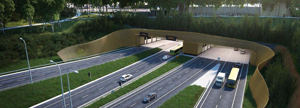
2 ARTISTS IMPRESSION - ST PETERS TUNNEL PORTAL ARTISTS IMPRESSION - ST PETERS TUNNEL PORTAL Figure 69 Artist s impression - St Peters Tunnel Portal 97
3 - ST PETERS EASTERN PORTAL - CONCEPT PLAN A3 Figure 70 St Peters eastern portal plan 98
4 LEGEND CANTILEVERED SCREEN PANELS CANTILEVERED SCREEN PANELS x 100 RHS ALUMINUM BATTENS WITH SELECT EPOXY FINISH EDGE BARRIER x 100 RHS ALUMINUM BATTENS WITH SELECT EPOXY FINISH EDGE BARRIER LEGEND CANTILEVERED SCREEN PANELS x 100 RHS ALUMINUM BATTENS WITH SELECT EPOXY FINISH TERRAMESH RETAINING WALLS WITH 'CORTEN' STEEL FACING PANEL TERRAMESH RETAINING WALLS WITH 'CORTEN' STEEL FACING PANEL SCREEN PLANTING EDGE BARRIER 14 SCREEN PLANTING OVERHEIGHT PROTECTION BARRIER OVERHEIGHT PROTECTION BARRIER 17 FOOTING TO ENGINEERS DETAIL FOOTING TO ENGINEERS DETAIL TERRAMESH RETAINING WALLS WITH 'CORTEN' STEEL FACING PANEL SCREEN PLANTING EXISTING GROUND LEVEL OVERHEIGHT PROTECTION BARRIER SCREEN PANELS FIXED TO PORTAL STRUCTURE APPROX. 30 PANELS 17 FOOTING TO ENGINEERS DETAIL TYPICAL PANEL WIDTH URE 99 DATE: 6/07/25 12:14:54 PM LOGIN NAME: JASON CUFFE LOCATION: \\sydproj\fs\62-61a-p\working\autocad\sheet\02. TUNNEL\M5 HAS DWG UD_SPI EASTERN PORTAL.dwg WESTCONNEX STAGE 2 NEW M5 MAIN WORKS DESIGN & CONSTRUCT 1 ISSUED TO REFLECT PROJECT POST-TENDER WIDE ADDENDUM 1 JS NOT ISSUED URBAN AND LANDSCAPE DESIGN REV DATE DESCRIPTION SPI 20 EASTERN 25 mm ON A3 ORIGINAL PORTAL New M5 WestConnex ELEVATION PROJECT 17 ELEVATION - EASTERN PORTAL FEATURE SCREEN 1:250 INITIAL DATE INFORMATION SHOWN ON THIS DRAWING IS PRELIMINARY ORIGINAL DRAWING ONLY AT A3 SIZE AND SUBJECT TO DRAFTSPERSON ADJUSTMENT DURING JS DETAILED DESIGN STAGE m STATUS DRAFTING CHECK CONCEPT MG DESIGN DESIGNER NOT FOR CONSTRUCTION JS 1 : 250 FULL SIZE A3 RFT APP.2 - TENDER INFORMATION DESIGN CHECK REQUIREMENTS MG VOLUME MG PM DESIGN MANAGER 2P - URBAN AND LANDSCAPE PM DESIGN DRAWN REVIEWED APPROVAL PROJECT DIRECTOR PC CO-ORDINATE SYSTEM: MGA Zone 56 HEIGHT DATUM: A.H.D. DRAWING NUMBER REV This Drawing may have been prepared using colour and may be incomplete if copied M5-HAS-DWG UD LEIGHTON DRAGADOS SAMSUNG C&T JOINT VENTURE ST PETERS EASTERN PORTAL INFORMATION - ELEVATION SHOWN ON 1:250 DRAWING A3 IS PRELIMINARY ONLY AND SUBJECT TO ADJUSTMENT DURING DETAILED DESIGN STAGE. STATUS WESTCONNEX STAGE 2 CONCEPT DESIGN NEW M5 MAIN WORKS DESIGN & CONSTRUCT NOT FOR CONSTRUCTION RFT APP.2 - TENDER INFORMATION REQUIREMENTS VOLUME PROJECT WIDE URBAN AND LANDSCAPE DESIGN 2P - URBAN AND LANDSCAPE DESIGN DRAWING NUMBER REV SPI Figure EASTERN 71 Indicative PORTAL St Peters Eastern Portal elevation ELEVATION M5-HAS-DWG UD-70 1 PROJECT INFORMATION SHOWN ON THIS DRAWING IS PRELIMINARY ONLY


5 LEGEND CANTILEVERED SCREEN PANELS 02 SCREEN PANELS FIXED TO PORTAL STRUCTURE x 100 RHS ALUMINUM BATTENS WITH SELECT EPOXY FINISH BASEPLATE EDGE BARRIER G.M.S GANTRY STRUCTURE FOR SUPPORT & MAINTENANCE ACCESS MAINTENANCE ACCESS STAIR G.M.S SCREEN PANEL SUPPORTING FRAME SUPER 'T' GIRDER TERRAMESH RETAINING WALLS WITH 'CORTEN' STEEL FACING PANEL 12 R.C. RETAINING WALLS 13 R.C. SLAB 14 SCREEN PLANTING 15 SELECT SOIL MIX & DRAINAGE 16 OVERHEIGHT PROTECTION BARRIER 17 FOOTING TO ENGINEERS DETAIL M HIGH SECURITY FENCE SHARED USER PATH SHARED USER PATH EXISTING GROUND LEVEL 2000 TYPICAL PANEL WIDTH TOP OF FACING PANEL G.L 9.00 G.L 4.50 DATE: 6/07/25 12:14:58 PM LOGIN NAME: JASON CUFFE LOCATION: \\sydproj\fs\62-61a-p\working\autocad\sheet\02. TUNNEL\M5 HAS DWG UD_SPI EASTERN PORTAL.dwg REV DATE 13 STANDARD LINING PANELS DESCRIPTION mm ON A3 ORIGINAL 10 TRANSITION SECTION ELEVATION - EASTERN PORTAL FEATURE SCREEN 1:250 ISSUED TO REFLECT POST-TENDER ADDENDUM 1 NOT ISSUED JS MG DRAFTSPERSON DRAFTING CHECK DESIGNER DESIGN CHECK DESIGN MANAGER INITIAL DRAWN REVIEWED APPROVAL PROJECT DIRECTOR PC This Drawing may have been prepared using colour and may be incomplete if copied PM JS MG JS MG PM 16 FEATURE SCREEN PANELS DATE ORIGINAL DRAWING AT A3 SIZE LEIGHTON DRAGADOS SAMSUNG C&T JOINT VENTURE m 1 : 250 FULL SIZE A3 CO-ORDINATE SYSTEM: MGA Zone 56 HEIGHT DATUM: A.H.D. G.L ST PETERS EASTERN PORTAL - SECTION INFORMATION ELEVATION SHOWN THIS DRAWING IS A3PRELIMINARY ONLY AND SUBJECT TO ADJUSTMENT DURING DETAILED DESIGN STAGE. STATUS WESTCONNEX Figure STAGE 72 Indicative 2 St Peters Eastern CONCEPT Portal elevation DESIGN NEW M5 MAIN WORKS DESIGN & CONSTRUCT NOT FOR CONSTRUCTION RFT APP.2 - TENDER INFORMATION REQUIREMENTS VOLUME PROJECT WIDE URBAN AND LANDSCAPE DESIGN 2P - URBAN AND Urban LANDSCAPE Design DESIGN DRAWING NUMBER REV SPI EASTERN PORTAL SECTION ELEVATION M5-HAS-DWG UD-71 1 PROJECT

6 5.7.7 Bridges The interchange includes a total of six road bridges and these would form a notable feature within the interchange landscape. Attention has been paid to the design detailing of these road bridges to ensure an elegant and minimalist form. Within the interchange itself the bridges would be stacked, providing connectivity between the St Peters portal, future M4-M5 Link portal, future Sydney Gateway, the New M5 ramps to Euston and Campbell Roads and Gardeners Road. To accommodate these connections the bridges would be layered in 4 levels. With mass planting in the interchange the scale of the road bridges would be tempered. Design intent The design approach to bridges in the interchange must carefully consider their forms, spans, profile, finishes and pier rhythm in conjunction with well-coordinated detailing. The architectural treatment of the bridges is considered paramount with clean lines and incorporating piers and abutments sympathetic to the structural form. The bridges would have architecturally profiled deck soffits and barrier edges to ensure an elegant finish befitting the critical importance of the iconic interchange. Feature lighting would also be included to highlight key elements of the structures. Within the interchange there are a number of feature bridges that would provide new connections: 1. Campbell Road bridge over Alexandra Canal A dedicated road bridge would be constructed, continuing the alignment of Campbell Road east over the Alexandra Canal connecting to Bourke Road (the Campbell Road bridge). The bridge would span the entire canal and allow for two eastbound and two west bound traffic lanes. In addition a shared cycle and pedestrian path would be included on the northern side of the bridge and a footpath on the southern side. The Alexandra Canal is a state heritage listed item owing to its rarity as one of only two artificial canals constructed in NSW. The design of the bridge respects the value of the canal by ensuring a clear span over the waterway. The clear span is designed to avoid disturbing the highly contaminated Alexandra Canal bed sediments. The bridge superstructure span is made up of six steel trough girders with a cast in-situ concrete deck. The continuous spans are designed to reduce the depth of the superstructure to minimise embankment height. Figure 73 Artist impression of Campbell Road bridge 1

7 ALEXANDRA CANAL N VOLUME 2 (p) APPENDIX A N ALEXANDRA CANAL CAMPBELL ROAD CAMPBELL ROAD 02 MPBELL ROAD BRIDGE OVER ALEXANDRA CANAL - PLAN 0 CAMPBELL ROAD BRIDGE OVER ALEXANDRA CANAL - PLAN 1:500 ALEXANDRA CANAL ALEXANDRA CANAL MPBELL ROAD BRIDGE OVER ALEXANDRA CANAL - ELEVATION 02 CAMPBELL ROAD BRIDGE OVER ALEXANDRA CANAL - ELEVATION 0 1:500 LEGEND LEGEND APPROACH SLAB APPROACH SLAB REINFORCED CONCRETE PIER REINFORCED CONCRETE PIER BRIDGE ABUTMENT BRIDGE ABUTMENT SHARED PATH SHARED PATH APPROXIMATE EXISTING SURFACE LEVEL APPROXIMATE EXISTING SURFACE LEVEL 2650 DEEP STEEL TROUGH GIRDER 2650 DEEP STEEL TROUGH GIRDER FOOTPATH FOOTPATH TWIN RAIL SAFETY BARRIER TWIN RAIL SAFETY BARRIER PEDESTRIAN SAFETY FENCE PEDESTRIAN SAFETY FENCE BRIDGE DECK BRIDGE DECK CAMPBELL ROAD BRIDGE OVER ALEXANDRA CANAL - SECTION 1:200 MPBELL ROAD BRIDGE OVER ALEXANDRA CANAL - SECTION Figure 74 Indicative plan Campbell Road bridge over Alexandra Canal BRIDGES - CAMPBELL STREET BRIDGE OVER ALEXANDRA CANAL 1:200 / A3 WESTCONNEX NEW M5 MAIN WORKS URBAN AND LANDSCAPE DESIGN 39

8 2. Gardeners Road Bridge over Alexandra Canal The Gardeners Road bridge would provide an easterly connection for vehicles travelling north on the New M5. Gardeners Road bridge would provide the main eastbound route from the interchange. The design of Gardeners Road bridge would feature a clear span over water and would be similar in overall appearance to the Campbell Road bridge. It would have a similar pier shape, span, barrier/edge details and abutments so that the two bridges read as a suite. Figure 75 Indicative Gardeners Road bridge over Alexandra Canal 1
6 BRIDGES. 6.1 Design philosophy. Proposed bridges
 SECTION 6 BRIDGES 6 BRIDGES Throughout the Project, bridges are a key visual element and marker for road users, pedestrians and cyclists. The design of bridges, as with other visible structures, has been
(blank page) WestConnex New M Roads and Maritime Services Environmental impact statement
 WestConnex New M Roads and Maritime Services Environmental impact statement") (blank page) WestConnex New M5 5-42 (blank page) WestConnex New M5 5-44 5.5 Tunnels 5.5.1 Main alignment tunnels The main alignment tunnels would be about nine kilometres long, with the western tunnel
(blank page) WestConnex New M5 5-42 (blank page) WestConnex New M5 5-44 5.5 Tunnels 5.5.1 Main alignment tunnels The main alignment tunnels would be about nine kilometres long, with the western tunnel
WestConnex PLAN. Note : This sub-plan is currently not approved by Department of Planning and Environment APPENDIX D
 ARNOTTS RESERVE URBAN DESIGN AND LANDSCAPE SUB- PLAN WestConnex Note : This sub-plan is currently not approved by Department of Planning and Environment 407 TABLE OF CONTENTS D1 INTRODUCTION 410 D1.1 Ministers
Open Space, Connectivity and Landscape Design
 6 Open Space, Connectivity and Landscape Design Open space, connectivity and landscape design 6.1 Open Space The inclusion of publicly accessible open space is a key benefit of the project s design. The
13 Land use and property
 13 Land use and property This chapter assesses land use and property impacts associated with the project. The assessment includes: Identification of the local land uses, existing access arrangements and
Sub-committee on Harbour Plan Review of Harbour-front Enhancement Committee. Ninth Meeting
 Sub-committee on Harbour Plan Review of Harbour-front Enhancement Committee Ninth Meeting Date: 5 October 2005 Time: 3:30pm Venue: Conference Room 15/F, North Point Government Offices, 333 Java Road, North
Section C Bridges and retaining walls
 Section C Bridges and retaining walls Above: This existing bridge on SH2 at Tauranga has a simple tapered column form that is a good precedent for the TEL. The open abutment optimises views along the highway
GLEN ROAD PEDESTRIAN BRIDGE ENVIRONMENTAL ASSESSMENT STUDY PUBLIC INFORMATION CENTRE #2 OCTOBER 24, 2017
 GLEN ROAD PEDESTRIAN BRIDGE ENVIRONMENTAL ASSESSMENT STUDY PUBLIC INFORMATION CENTRE #2 OCTOBER 24, 2017 Glen Road Pedestrian Bridge Class Environmental Assessment 1 WELCOME! Welcome to the second Public
M4-M5 Link Rozelle Interchange factsheet 2017
 M4-M5 Link Rozelle Interchange factsheet 017 WestConnex is part of the ustralian and NSW governments vision for supporting Sydney s growing population and keeping our economy strong. The M4-M5 Link is
ST PETERS INTERCHANGE - AERIAL VIEW WEST OVER TUNNEL PORTAL AND MOC4 FACILITY (Artist's impression only subject to change during design development)
") ST PETERS INTERCHANGE - AERIAL VIEW WEST OVER TUNNEL PORTAL AND MOC4 FACILITY (Artist's impression only subject to change during design development) i WESTCONNEX NEW M5 URBAN DESIGN AND LANDSCAPE PLAN
ST PETERS INTERCHANGE - AERIAL VIEW WEST OVER TUNNEL PORTAL AND MOC4 FACILITY (Artist's impression only subject to change during design development) i WESTCONNEX NEW M5 URBAN DESIGN AND LANDSCAPE PLAN
Victoria Bridge Municipal Class EA Civic Works Committee
 Municipal Class EA John Pucchio, P. Eng., Project Manager June 19 2018 Introduction Existing Conditions Municipal Class EA Proposed Bridge Proposed Road Reconstruction Proposed Improvements Construction
PRELIMINARY DESIGN + DEVELOPMENT PLAN
 WELCOME! To The Public Open House May 30 th, 2017 HARBOUR WEST PARKS Vision Project Overview The City s vision for Port Credit Harbour West Parks is to develop a vibrant waterfront destination that integrates
ROAD CONSTRUCTION. 36 June 2014 ROADS&BRIDGES
 ROAD CONSTRUCTION 36 June 2014 ROADS&BRIDGES Young is full of life Recent expansion completes continuous, multilane arterial By Donald Hammack, P.E. Contributing Author The Florida Department of Transportation
Option A FINAL AESTHETIC SIGNATURE BRIDGE PROPOSAL. SR 836/I-395/I-95 Project
 ELECTRONIC COPY AESTHETIC VOLUME 2 2.28.17 APPROVED SIGNATURE BRIDGE PACKAGE, APTES, AND SIGNATURE BRIDGE RELATED ATCS SR 836/I-395/I-95 Project Florida Department of Transportation District 6 & Miami-Dade
Urban and Landscape Design Frameworks Highways and Network Operations Guideline
 Urban and Landscape Design Frameworks Highways and Network Operations Guideline The following outlines the process to be followed through the planning, design and construction phases of a state highway
Recreational Pathway Crossing of Richmond Street Municipal Class Environmental Assessment. Public Information Centre #2 April 22, 2015
 Recreational Pathway Crossing of Richmond Street Municipal Class Environmental Assessment Public Information Centre #2 April 22, 2015 1. Study Process PHASE 1 PHASE 2 PHASE 3 PHASE 1 : Problem/Opportunity
B5.2 Open Scenarios: Viaducts
 B5.2 Open Scenarios: Viaducts As the HS2 line approaches a crossing, it is usually at a height above ground level. In many cases, the most appropriate way to deal with this level difference is with an
Cleveland Innerbelt Bridge / Central Viaduct City Planning Commission November 6, 2009
 Cleveland Innerbelt Bridge / Central Viaduct City Planning Commission November 6, 2009 Process for Aesthetics Subcommittee June 25, 2009 Kick off Meeting June 26, 2009 Gateway and Tremont Focus Groups
Welcome to this public consultation event for the proposed South Western Relief Road. Thank you for taking the time to come along.
 WELCOME Welcome to this public consultation event for the proposed South Western Relief Road. Thank you for taking the time to come along. The South Western Relief Road (SWRR) route is proposed in Stratford-on-Avon
Great Lakes North Central South Central FAX: (718) CONTACT PERSON: ADDRESS: Daniel Hom, PE, Engineer-in-Charge
 CONTACT PERSON: ADDRESS: Daniel Hom, PE, Engineer-in-Charge") AMERICAN SOCIETY OF HIGHWAY ENGINEERS National Project of the Year Award OFFICIAL ENTRY FORM AWARD CATEGORY (Check One): Under $20 Million Over $20 Million SPONSORING REGION (Check One): Northeast Mid-Atlantic
AMERICAN SOCIETY OF HIGHWAY ENGINEERS National Project of the Year Award OFFICIAL ENTRY FORM AWARD CATEGORY (Check One): Under $20 Million Over $20 Million SPONSORING REGION (Check One): Northeast Mid-Atlantic
Longbridge Town Centre Phase 2 Planning Application
 Longbridge Town Centre Phase 2 Planning Application Non-Technical Summary of the Environmental Statement December 2013 Introduction A full application for Planning Permission has been submitted to Birmingham
Final Design Meeting. September 25, Creating Bridges As Art. Welcome & Introductions. Terry Ward - Project Manager
 Final Design Meeting September 25, 2014 Creating Bridges As Art 1 Welcome & Introductions Terry Ward - Project Manager 2 VQRC Final Design Meetings Meeting Date Items for Discussion Final Design Meeting
MINNESOTA ARCHITECTURE - HISTORY INVENTORY FORM
 Identification Historic Name Dean Parkway Bridge Current Name Bridge 90661 Field # Address Midtown Greenway over Dean Parkway City/Twp Minneapolis County Hennepin Legal Desc. Twp 29N Range 24W Sec 32 QQ
Development Control Plan
 Development Control Plan Rhodes Corporate Park (Also known as the Digital Site) Development Control Plan Date of Adoption: 4 September 2007 Effective Date: 7 March 2008 Index 1 INTRODUCTION... 3 1.1 LAND
Chapter 27 Route Window SE7 Church Manorway Bridge. Transport for London
 Chapter 27 Route Window SE7 Church Manorway Bridge Transport for London CHURCH MANORWAY BRIDGE 27 Route Window SE7 Church Manorway bridge Introduction 27.1 The North Kent Line will be converted to four
Bridge Type Assessment and Evaluation
 16M-01410-01 (3216026) Glen Road Pedestrian Bridge EA Study Bridge Type Assessment and Evaluation Factor Group/Criteria Alternative 1: Steel girder with two inclined steel legs Alternative 2: Steel girder
MVRC ARCHITECTURAL DESIGN STATEMENT
 11251 MOONEE VALLEY RACING CLUB MAY 201 CONTENTS 0 Contents Introduction 1 Site Analysis a. Site Features b. Built form Interfaces c. Existing Streetscape d. Site Opportunities and Constraints 2 Masterplan
Subject: Expo Light Rail - Revision of the Terminus Station North Entrance Design
 Information Item Date: June 12, 2012 To: Mayor and City Council From: David Martin, Director, Planning & Community Development Martin Pastucha, Director, Public Works Kathryn Vernez, Deputy City Manager
Draft Eastern District Plan
 Draft Eastern District Plan Submission_id: 31238 Date of Lodgment: 13 Dec 2017 Origin of Submission: Online Organisation name: Turrulla Gardens Pty Ltd C/- Mecone Organisation type: Industry First name:
Appendix H: Easement cross sections
 Appendix H: Easement cross sections SHARED PATH 1.5m FOOTPATH NATURE STRIP 7.3m CARRIAGEWAY 2.7m NATURE STRIP EXISTING PIPELINE 150mm DIA 5.0m (approx.) LOCAL ACCESS ROAD EXISTING PIPELINE 500mm DIA 2.7m
APPENDIX K WINDSOR OFFICIAL PLAN
 CEAA ENVIRONMENTAL ENVIRONMENTAL IMPACT ASSESSMENT AMBASSADOR BRIDGE ENHANCEMENT PROJECT Replacement Span and Plaza Expansion APPENDIX K WINDSOR OFFICIAL PLAN Avalon Consulting Professionals of Ontario,
Cleveland Innerbelt Bridge / Central Viaduct Cleveland City Planning Commission October 2, 2009
 Cleveland Innerbelt Bridge / Central Viaduct Cleveland City Planning Commission October 2, 2009 New Westbound Bridge Schedule December 1, 2009 Contract Documents/Plan Package March 1, 2010 Request for
Design of Movable Bridges - selected examples
 Design of Movable Bridges - selected examples Adriaan Kok Designer, Project Manager ipv Delft Delft, The Netherlands adriaankok@ipvdelft.nl Niels Degenkamp Designer, Project Manager ipv Delft Delft, The
10/18/2010. Today s presentation will focus on what the construction engineer can do to help deliver a successful bridge project
 Field Construction Engineering Aspects of Bridge Construction Virginia Tech Construction Engineering Conference Thomas DeHaven, P.E. Executive Vice President - Figg Bridge Inspection, Inc. October 1, 2010
Start of works exhibition
 Start of works exhibition Find out about the work that Highways England are undertaking to create a new interchange junction 700 metres east of junction 10 over the M20, a dual carriageway link road to
21. GREENWICH ROUTE SECTION ENVIRONMENTAL BASELINE AND ASSESSMENT OF IMPACTS... 2
 21. GREENWICH ROUTE SECTION ENVIRONMENTAL BASELINE AND ASSESSMENT OF IMPACTS... 2 21.1 OVERVIEW OF GREENWICH ROUTE SECTION... 2 21.2 POLICIES RELEVANT TO ALL WORKSITES IN GREENWICH... 3 21.3 WARREN LANE
SCHEDULE 12 TO THE DESIGN AND DEVELOPMENT OVERLAY GLEN WAVERLEY ACTIVITY CENTRE STRUCTURE PLAN
 DD/MM/YY Proposed C120 SCHEDULE 12 TO THE DESIGN AND DEVELOPMENT OVERLAY Shown on the planning scheme map as DDO12. GLEN WAVERLEY ACTIVITY CENTRE STRUCTURE PLAN 1.0 Design objectives DD/MM/YY Proposed
5.2 LAND USE AND ZONING
 5.2 LAND USE AND ZONING This section describes the land use and zoning of the project site and surrounding area, followed by an analysis of the potential for incompatibility or adverse impact on prevailing
DESIGN PARAMETERS DESIGN OBJECTIVES. Design Focus and the Elements of the Corridor. Driver Confidence. Visual Organization.
 Design Focus and the Elements of the Corridor LBJ Corridor DESIGN PARAMETERS For any project to be successful, the project goals must be clear. Therefore, with the assistance of TxDOT, the Urban Design
Canal & River Trust response to the Consultation on the Working Draft Environmental Impact Assessment Report
 High Speed Two Phase 2a: West Midlands to Crewe Response to Working Draft Environmental Impact Assessment Report Please find below the response of the Canal & River Trust. The Trust is the guardian of
Appendix SPAIN Madrid M30-Río-TUNNEL
 Appendix 2.17 - SPAIN Madrid M30-Río-TUNNEL 1. INTRODUCTION The M30-Río Tunnel is located in Madrid (Spain), a city of about 3,200,000 inhabitants. The M30 is the main ring road, linking all the neighbourhoods
E kv Transmission Line Underground Relocation Project. Initial Evaluation of Bridge Structures
 E-183 115 kv Transmission Line Underground Relocation Project Introduction Initial Evaluation of Bridge Structures July 11, 2017 Robinson and Cole, LLP contacted Power Delivery Consultants, Inc. (PDC)
Western Belfast Bypass almost finished
 ROADS OF NATIONAL SIGNIFICANCE CHRISTCHURCH MOTORWAYS Western Belfast Bypass PROJECT UPDATE October 2017 Western Belfast Bypass almost finished The Western Belfast Bypass (WBB) project is 95 per cent complete
Authority. any changes required as a result of the approved CHMP.
 PLANNING PERMIT Permit No. Planning Scheme Responsible Authority../2013 Greater Geelong Planning Scheme Greater Geelong City Council ADDRESS OF THE LAND 5, 15, 21, 23, 1/23, 25, 33, 40 and 50 Caddys Road;
GREENBANK DEVELOPMENT MASTERPLAN
 DEVELOPMENT MASTERPLAN POTENTIAL TRAIN STATION COMMUNITY CENTRE Greenbank will be a connected masterplanned community providing easy access to local and surrounding amenity. Affordable quality homes, green
Corridor Enhancements
 Corridor Enhancements Safety is MoDOT s first priority in widening and rebuilding I-70 across the state of Missouri. MoDOT also understands that the interstate - and its interchanges and overpasses - are
I-70 Corridor Enhancement Plan
 i - Table of Contents Table of Contents Chapter I Overview Chapter II Bridge and Roadway Improvements Chapter III Landscape Enhancements Chapter IV Riparian Corridors Chapter V Showcase Missouri Plan Chapter
Patrick Thompson. Associate Director, Bridge & Specialist Structures, WA. Experience Overview
 , Bridge & Specialist Structures, WA Experience Overview Patrick Thompson has 17 years experience as a structural engineer in bridge design and design management of multidisciplinary infrastructure projects.
A. INTRODUCTION B. PROJECT LOCATION
 Chapter 1: Project Description A. INTRODUCTION The Lower Manhattan Development Corporation (LMDC), a subsidiary of the New York State Urban Development Corporation, doing business as the Empire State Development
Construction and Landscaping on Public Property
 Construction and Landscaping on Public Property City of Manhattan Beach Community Development Department 1400 Highland Avenue 310-802-5504 www.citymb.info January, 2004 Construction and Landscaping on
DESIGN SCENE SUBJECT INDEX
 DESIGN SCENE SUBJECT INDEX CHAPTER 1: TITLE SHEET and GENERAL LAYOUT AREA OF ENVIRONMENTAL SENSITIVITY BRIDGE & APPROACH PLANS CONSTRUCTION PLAN FOR EXCEPTIONS EXCEPTION CLARIFICATION GOVERNING SPECIFICATIONS
ARTICLE VI: SITE PLAN REVIEW
 Section 6.01 - Site Plan Review (All Districts) ARTICLE VI: SITE PLAN REVIEW Site plans give the Planning commission an opportunity to review development proposals in a concise and consistent manner. The
Plat Requirements CHECKLIST FOR SITE PLAN REVIEW
 This checklist is to be used as a guide for complying with the Town of Hollis Site Plan Regulations. It is to be used for each individual site plan review application submitted. Applicants are encouraged
REPORT TO: Council FOR: Regular Meeting. PRESENTED: April 1, 2008 FILE: , Byl 1932 & 1936
 DISTRICT OF SQUAMISH REPORT TO: Council FOR: Regular Meeting PRESENTED: April 1, 2008 FILE: 2006-08, Byl 1932 & 1936 DEPARTMENT: Planning Department SUBJECT: First and Second Readings for Bylaws 1932 (rezoning)
4.0 AFFECTED ENVIRONMENT AND ENVIRONMENTAL CONSEQUENCES
 4.0 AFFECTED ENVIRONMENT AND ENVIRONMENTAL CONSEQUENCES The following sections discuss the impacts associated with environmental resources for the tunneling method Alternatives A and B. The construction
The Village. Chapter 3. Mixed Use Development Plan SPECIFIC PLAN
 The Village SPECIFIC PLAN Chapter 3 3.1 INTRODUCTION 3.1.1 Purpose This Chapter describes the development regulations applicable to the Mixed-Use and Transit Center Planning Areas. These form-based regulations
8.0 Management Measures
 155 8.0 Management Measures 8.1 Introduction Chapter 7.0 identified that there is potential for heritage items to be potentially impacted directly or indirectly, by vibration and settlement associated
APPENDIX D: Visual and Aesthetic Conditions for NCCU Station Refinement. Durham-Orange Light Rail Transit Project
 APPENDIX D: Visual and Aesthetic Conditions for NCCU Station Refinement Durham-Orange Light Rail Transit Project October 2016 1. Introduction The Combined FEIS/ROD summarizes the effects of the D-O LRT
Historic Bridge Foundation Facebook Archives
 Historic Bridge Foundation Facebook Archives Focus Bridges: Firth of Forth Bridges September 2017 The Firth of Forth in Scotland is a unique location perhaps one of the only locations in the world where
Design Guidelines and Standards for Sight Triangles. Sight Triangle MANUAL
 Design Guidelines and Standards for Sight Triangles Sight Triangle MANUAL Table of Contents 1.0 Introduction..............................................7 1.1 Key Terms..............................
Derby-Shelton Bridge Pedestrian and Bicyclist Enhancements [1]
![Derby-Shelton Bridge Pedestrian and Bicyclist Enhancements [1]](/thumbs/96/128011958.jpg "Derby-Shelton Bridge Pedestrian and Bicyclist Enhancements [1]") nhancements [1] STATUS OF PROJECT: The project has recently moved from the Preliminary Design Phase to the Final Design Phase following the most recent Public Involvement Meeting held on January 9, 2019
nhancements [1] STATUS OF PROJECT: The project has recently moved from the Preliminary Design Phase to the Final Design Phase following the most recent Public Involvement Meeting held on January 9, 2019
Memorials, Plaques & Interpretive Signs Policy
 Memorials, Plaques & Interpretive Signs Policy APPROVAL COUNCIL DATE / CEO VERSION NO: Version 0.4 TRIM REF: 16/31097 REVIEW 30 June 2020 RESPONSIBLE EXECUTIVE General Manager City Assets & Environment
ONLINE PUBLIC INFORMATION CENTRE
 ONLINE PUBLIC INFORMATION CENTRE County Road 17 Bridge Replacements Detail Design and Environmental Assessment GWP 4203-15-00 The Ministry of Transportation Ontario (MTO) has retained CH2M Hill and Dillon
Urban Design Manual 2.0 DRIVE-THROUGH FACILITIES. Background. Urban Design Challenges
 222221 2.0 DRIVE-THROUGH FACILITIES Background In recent years, drive-through facilities have grown significantly in popularity with drive-through restaurants, in particular, being established on numerous
Mississippi Skyway Preliminary Engineering Report
 EXECUTIVE SUMMARY Mississippi Skyway Preliminary Engineering Report CITY OF RAMSEY, MINNESOTA DECEMBER 2014 City of RAMSEY EXECUTIVE SUMMARY Project Need and Intent The Mississippi Skyway pedestrian bridge
WestConnex. New M5 State Significant Infrastructure Application Report. November 2014 ISBN:
 WestConnex New M5 State Significant Infrastructure Application Report November 2014 ISBN: 978-1-925217-04-9 (blank page) The New M5 November 2014 Prepared for Prepared by AECOM Australia Pty Ltd Level
14. NEWHAM ROUTE SECTION - ENVIRONMENTAL BASELINE AND ASSESSMENT OF IMPACTS... 20
 14. NEWHAM ROUTE SECTION - ENVIRONMENTAL BASELINE AND ASSESSMENT OF IMPACTS... 2 14.1 OVERVIEW OF NEWHAM ROUTE SECTION... 2 14.2 POLICIES RELEVANT TO ALL WORKSITES IN NEWHAM... 3 14.3 PUDDING MILL LANE
STILL CREEK CD-1 GUIDELINES (BY-LAW NO. 6654) Adopted by City Council April 24, 1990
 Adopted by City Council April 24, 1990") $2 City of Vancouver Land Use and Development Policies and Guidelines Community Services, 453 W. 12th Ave Vancouver, BC V5Y 1V4 F 604.873.7344 fax 873.7060 planning@city.vancouver.bc.ca STILL CREEK CD-1
$2 City of Vancouver Land Use and Development Policies and Guidelines Community Services, 453 W. 12th Ave Vancouver, BC V5Y 1V4 F 604.873.7344 fax 873.7060 planning@city.vancouver.bc.ca STILL CREEK CD-1
Lancaster Conservation Area Appraisal. Character Area 8. Cathedral
 Lancaster Conservation Area Appraisal Character Area 8. Cathedral March 2013 118 3.8 Character Area 8. Cathedral 3.8.1. Definition of Special Interest "This character area is distinctive for the fine group
The Anaheim Resort Public Realm Landscape Program. City of Anaheim. Adopted September 1994 (94R-239)
") Public Realm Landscape Program City of Anaheim Adopted September 1994 (94R-239) Amendment No. 1 October 1996 (96R-178) Amendment No. 2 June 1999 (99R-137) Amendment No. 3 February 2001 (2002R-56) Amendment
Public Realm Landscape Program City of Anaheim Adopted September 1994 (94R-239) Amendment No. 1 October 1996 (96R-178) Amendment No. 2 June 1999 (99R-137) Amendment No. 3 February 2001 (2002R-56) Amendment
NEWSLETTER #03 BEAUDESERT ROAD LOGAN MOTORWAY
 NEWSLETTER #03 MT. LINDESAY HIGHWAY Feedback shapes design changes Thank you to the more than 600 stakeholders and community members that provided feedback on the Logan Enhancement Project initial concept
ELMVALE ACRES SHOPPING CENTRE MASTER PLAN
 ELMVALE ACRES SHOPPING CENTRE MASTER PLAN Contents 1.0 INTRODUCTION... 2 2.0 LOCATION... 2 3.0 EXISTING CONTEXT... 2 4.0 VISION & GUIDING PRINCIPLES... 2 5.0 LAND USE AND BUILT FORM... 4 5.1 St. Laurent
Urban Design Review Panel Submission. The Ottawa Train Yards - Office Development. 405 Terminal Avenue. 17 April Table of Contents.
 Table of Contents PHOTOGRAPHS OF EXISTING SITE CONDITION URBAN DESIGN BRIEF PART A: Summary and Response to City Urban Design Guidelines and Policies PART B: Site Specific Urban Design Objectives PART
I-25 / Rio Bravo Interchange. I-25 / Rio Bravo Interchange. Presenters 11/30/2016 THIRD PUBLIC MEETING DECEMBER 1, 2016 NMDOT CN A300280
 I-25 / Rio Bravo Interchange TONIGHT S MEETING SCHEDULE OPEN HOUSE 6:00 PM TO 6:30 PM PRESENTATION BEGINS AT 6:30 PM Q & A FOLLOWING PRESENTATION CN A300280 / PNA300280 I-25 / Rio Bravo Interchange THIRD
Ensure that development within the Arrowtown Urban Growth Boundary provides:
 URBAN DEVELOPMENT 4 4.2.5.2 Ensure that development within the Arrowtown Urban Growth Boundary provides: an urban form that is sympathetic to the character of Arrowtown, including its scale, density, layout
HS2 Interchange Station Design
 Working on behalf of HS2 Interchange Station Design October 2018 www.hs2.org.uk 1 Interchange Station, Solihull Introduction In February 2018, HS2 Ltd appointed Arup to take forward the design of Interchange
Former Rockcliffe Airbase Community Design Plan Guiding Design Vision and Principles December 4, 2013
 APPENDIX 5 - Guiding Design Vision and Principles Former Rockcliffe Airbase Community Design Plan Guiding Design Vision and Principles December 4, 2013 Vision Statement The redevelopment of the former
WEST LOOP DESIGN GUIDELINES CHECKLIST
 WEST LOOP DESIGN GUIDELINES CHECKLIST Section 1.0 General Strategies 1.1 DESIGN EXCELLENCE: ENCOURAGE HIGH QUALITY AND INNOVATIVE DESIGN OF NEW BUILDINGS WITHIN THE WEST LOOP WITHOUT BEING PRESCRIPTIVE
MILTON HEIGHTS COMMUNITY January 2006 Revised February 2015 Revised November 2015
 REVISED DRAFT MILTON HEIGHTS COMMUNITY January 2006 Revised February 2015 Revised November 2015 Urban Design Guidelines Milton Heights Landowners Group This page has been intentionally left blank. Contents
7.2.9 Eudlo local plan code
 7.2.9 local plan code 7.2.9.1 Application (1) This code applies to assessable development:- (a) within the local plan area as shown on Map ZM29 contained within Schedule 2 (Mapping); and (b) identified
Waterways Wetland & Estate
 Waterways Wetland & Estate Substantial new structure within this naturally perceived landscape Use architecturally custom-designed bridge, materials, noise walls, abutments and embankments that respond
Fig 31 INDICATIVE SITE SECTION - KENT/ CAMBRIDGE TERRACE (NOTE: SECTION TO SCALE BACKGROUND PERSPECTIVE INDICATIVE SCALE) EXISTING TREE
 EXISTING TREE") EXISTING TREE NEW TREE NEW TREE BRIDGE BASIN BUILT SQUARE NEW TREE BASIN OUTER SQUARE NORTHERN GATEWAY BUILDING BASIN INNER CIRCLE BASIN RESERVE BUCKLE ST KENT/ CAMBRIDGE TCE INDICATIVE SITE SECTION -
EXISTING TREE NEW TREE NEW TREE BRIDGE BASIN BUILT SQUARE NEW TREE BASIN OUTER SQUARE NORTHERN GATEWAY BUILDING BASIN INNER CIRCLE BASIN RESERVE BUCKLE ST KENT/ CAMBRIDGE TCE INDICATIVE SITE SECTION -
RESOURCE PACKET River Crossing
 RESOURCE PACKE River Crossing Overall Project Focus: "River Crossing" project is funded through an NEA Our own grant that provides a comprehensive plan for public art and arts experiences that will connect
LEVEL TWO UNIFIED PERMIT CHECKLIST FOR DETERMINATION OF COMPLETENESS [Devens Enterprise Commission Rules and Regulations 2018]
![LEVEL TWO UNIFIED PERMIT CHECKLIST FOR DETERMINATION OF COMPLETENESS [Devens Enterprise Commission Rules and Regulations 2018]](/thumbs/92/110164057.jpg "LEVEL TWO UNIFIED PERMIT CHECKLIST FOR DETERMINATION OF COMPLETENESS [Devens Enterprise Commission Rules and Regulations 2018]") LEVEL TWO UNIFIED PERMIT CHECKLIST FOR DETERMINATION OF COMPLETENESS [Devens Enterprise Commission Rules and Regulations 2018] Name of applicant and project: Date of Issuance of this DOC: List Regulatory
LEVEL TWO UNIFIED PERMIT CHECKLIST FOR DETERMINATION OF COMPLETENESS [Devens Enterprise Commission Rules and Regulations 2018] Name of applicant and project: Date of Issuance of this DOC: List Regulatory
DAVENPORT VILLAGE SECONDARY PLAN
 27 DAVENPORT VILLAGE SECONDARY PLAN 27. DAVENPORT VILLAGE SECONDARY PLAN 1. VISION FOR THE DAVENPORT VILLAGE SECONDARY PLAN Davenport Village, municipally known as 830, 940, 980 and 1100 Lansdowne Avenue,
4.3 Dudley Area Plan. Introduction. History and Existing Character. Desired Future Character for Dudley
 4.3 Dudley Area Plan Introduction The suburb of Dudley has developed as a result of various circumstances including its topography, history and mineral resources. Dudley development has been identified
DESIGN OF FOOTBRIDGES
 Civil Engineering Technical Requirement CIVIL-SR-006 DESIGN OF FOOTBRIDGES Revision: 9 Updated: 26/08/2015 Queensland Rail 2015 Reproduction by any means (including electronic, mechanical, photocopying,
Welcome. Walk Around. Talk to Us. Write Down Your Comments
 Welcome This is an information meeting introducing the applications for proposed redevelopment of the Yorkdale Shopping Centre site at 3401 Dufferin Street and 1 Yorkdale Road over the next 20+ years,
CONFORMED AGREEMENT INCORPORATED REVISIONS PER AMENDMENT DATED: APRIL 2, 2013 FOR REFERENCE
 CONFORMED AGREEMENT INCORPORATED REVISIONS PER AMENDMENT DATED: APRIL 2, 2013 FOR REFERENCE CITY STREETS AS PART OF STATE HIGHWAYS GUIDELINES REACHED BY THE WASHINGTON STATE DEPARTMENT OF TRANSPORTATION
OUR GREATER SYDNEY A metropolis of three cities. OVERVIEW. connecting people. DRAFT Greater Sydney Region Plan
 OUR GREATER SYDNEY 2056. A metropolis of three cities. OVERVIEW. connecting people. DRAFT Greater Sydney Region Plan October 2017 This document is an overview of the draft Greater Sydney Region Plan. To
MEMORANDUM. I2 District Downtown Parking Overlay District 24,000 square feet /.55 acres. Industrial Employment District North Loop Small Area Plan
 Department of Community Planning & Economic Development 50 South 4th Street, Room 300 Minneapolis, MN 5545-385 MEMORANDUM To: City Planning Commission, Committee of the Whole Prepared By: Peter Crandall,
I-4 Beyond the Ultimate. Florida Transportation Builders Association February 9, 2018
 I-4 Beyond the Ultimate Florida Transportation Builders Association February 9, 2018 FDOT: Improving Mobility & Safety in Central Florida FDOT is Designing and building a better I-4 through Central Florida
Victoria Street Pedestrian Bridge
 Township of Centre Wellington Victoria Street Pedestrian Bridge Class Environmental Assessment County of Wellington & Township of Centre Wellington Badley Bridge Replacement/Rehabilitation (County of Wellington),
Community Sensitive Design: (Context Sensitive Design)
") What is? Community Sensitive Design: (Context Sensitive Design) The process by which urban design, land-use planning and aesthetic enhancements are applied to a project to make it an integral part of the
What is? Community Sensitive Design: (Context Sensitive Design) The process by which urban design, land-use planning and aesthetic enhancements are applied to a project to make it an integral part of the
Welcome to the Sellwood Bridge Project Pre-Construction Open House
 Welcome to the Sellwood Bridge Project Pre-Construction Open House 5:30 7:30 p.m. Please sign in here Information stations and project staff are located throughout the room. Goals for Tonight s Meeting
Bel-Air Lexus Automobile Service Station
 Bel-Air Lexus Automobile Service Station Design Brief 443-447 McArthur Avenue Ottawa April 30, 2015 14-1299-MCA Site Details Application: Site Plan Control Legal Description and Municipal Addresses: 443
WELCOME TO PUBLIC INFORMATION CENTRE #2. Please Sign In
 WELCOME TO PUBLIC INFORMATION CENTRE #2 Replacement of Oxtongue Lake Narrows Bridge & Oxtongue River Bridge, Highway 60 (G.W.P. 93-89-00 & G.W.P. 5550-04-00) Class Environmental Assessment (Group B) Please
City of Cornwall Municipal Class Environmental Assessment. Proposed Improvement and Extension of Lemay Street
 Welcome City of Cornwall Municipal Class Environmental Assessment Proposed Improvement and Extension of Lemay Street Redevelopment and Design of the Municipal Works Yard Public Information Centre #1 Thursday,
APPLICATION BRIEFING Prepared For: Submitted by: Date: Subject:
 Planning & Development APPLICATION BRIEFING Prepared For: Submitted by: Date: Subject: Planning Advisory Committee Jason Fox, Director of Planning & Development Development Agreement application by Godfrey
A. INTRODUCTION B. NO ACTION ALTERNATIVE
 Chapter 19: Alternatives A. INTRODUCTION Over the years a variety of potential developments for the East River waterfront in Lower Manhattan have been considered. Some of these plans were very ambitious