PROJECT BRIEF HOBART INTERIM PLANNING SCHEME 2015 CENTRAL BUSINESS ZONE HEIGHT STANDARDS PERFORMANCE CRITERIA REVIEW
|
|
|
- Alexia Williams
- 5 years ago
- Views:
Transcription
1 PROJECT BRIEF HOBART INTERIM PLANNING SCHEME 2015 CENTRAL BUSINESS ZONE HEIGHT STANDARDS PERFORMANCE CRITERIA REVIEW REQUIRED EVALUATION RETURNS In order to enable evaluation of your company s submission, ensure the following information is submitted with the quotation: Item Return Description 1. Lump sum fee proposal for the services. Itemised breakdown of the total project costs, including stages, key tasks, personnel hours and rates, and any expenses. 2. Disclosure of any matters that could ultimately lead to a conflict of interest in undertaking the service. 3. Details of the proposed methodology, including the timing of key tasks, stages, milestones, deliverables and key dates. STATEMENT OF REQUIREMENTS 1. DESCRIPTION 2. The City of Hobart is seeking to engage a suitably qualified and experienced Contractor to undertake a review of the performance criteria and related objectives used in the height standards in the Central Business and Commercial Zones (Attachment A) in the Hobart Interim Planning Scheme 2015 (HIPS2015). 3. PROJECT TIMEFRAME It is anticipated that the services will be completed in accordance with this brief by 30 November BACKGROUND The development standards for buildings in the Central Business and Commercial Zones in the HIPS2015 were formulated after a detailed review and analysis of land use and development patterns in the central area. The results of this work are documented in the Central Area Review Background Report (HCC 2013). The development standards address building height, setbacks, design, passive surveillance, outdoor storage and pedestrian links. The building height standards in the Central Business Zone (clause Attachment B) include an Amenity Building Envelope which has been developed with regard to heritage, streetscape and sense of scale, wind effects and solar penetration. The performance criteria in clause (b) provides that development outside the Amenity Building Envelope must only be approved if: 1
2 (i) it provides overriding benefits in terms of economic activity and civic amenities, unless an extension to an existing building that already exceeds the Amenity Building Envelope; and (ii) the siting, bulk and design does not significantly negatively impact on the streetscape and townscape of the surrounding area; and (iii) the design demonstrates that it will minimise unacceptable wind conditions in adjacent streets; and (iv) for city blocks with frontage to a Solar Penetration Priority Street in Figure 22.2, the overshadowing of the public footpath on the opposite side of the Solar Penetration Priority Street is not increased between the hours of 11am and 3pm at the spring or autumn equinox compared with the existing situation. Since the introduction of the HIPS2015 in May 2015 one significant development application has been submitted for a building outside the Amenity Building Envelope (28-32 Elizabeth St. - Palace Hotel). The assessment of this proposal identified limitations in the use of performance criteria (b)((ii) and concerns have been expressed that this criteria may not provide sufficient guidance to ensure that impacts on streetscape, townscape and heritage values are acceptable. Additional standards in clause A4/P4 and A5/P5 and in the Historic Heritage Code (E13.0) apply to development on or adjacent to heritage listed places. The building height standards in the Commercial Zone (clause Attachment C) have been developed with regard to streetscape and scale considerations. 5. OBJECTIVES The objectives of this project are: (i) To assess whether or not the performance criteria (b)(ii) in clause provides sufficient guidance for assessing applications for development outside of the Amenity Building Envelope to ensure that impacts on streetscape and townscape values in the Central Business Zone are acceptable. (ii) To draft appropriate amendments to the objective and performance criteria in clause (b) and draft desired future character statements if it is concluded that the current criteria do not provide sufficient guidance to ensure that impacts on streetscape and townscape values are acceptable. (iii) To identify issues related to townscape considerations relevant to the translation of the HIPS2015 and the Sullivans Cove Planning Scheme 1997 into the Hobart Local Provisions Schedule of the Tasmanian Planning Scheme. (iv) Review the building height standards in the Commercial Zone (clause ) and evaluate whether or not they will ensure that building height contributes positively to the streetscape and will not adversely impact on the townscape in the central business area. 2
3 6. SCOPE Key Tasks: 1. Based on work already undertaken for the Central Area Strategy Plan Townscape Report (1991 HCC), City of Hobart Urban Design Principles Project (2004 L Woolley), Views Experiencing Sullivans Cove (2011 L Woolley) and the Townscape Assessment Elizabeth Street (2015 L Woolley) identify the key streetscape and townscape values that require consideration when assessing buildings proposed outside of the Amenity Building Envelope. 2. Evaluate and articulate how the landform of the City and CBD informs the key townscape values that require consideration. Use existing case studies such as that for the Civic Square Masterplan to inform this work. 3. Assess whether or not consideration of the building elements related to; siting, bulk and design alone are adequate to ensure that impacts on streetscape and townscape values in the Central Business Zone are acceptable when buildings outside the Amenity Building Envelope are proposed. Identify additional elements for consideration if deemed necessary. 4. Assess whether or not the phrase: does not significantly negatively impact provides sufficient guidance for assessing applications for development outside of the Amenity Building Envelope. Identify additional statements for consideration if deemed necessary. 5. If considered necessary draft appropriate amendments to the performance criteria in clause (b) to ensure that potential adverse impacts on streetscape and townscape values from buildings outside the Amenity Building Envelope are acceptable. 6. If considered necessary draft appropriate amendments to the objective for the building height standards (22.4.1) to reflect any changes to the performance criteria in clause (b). 7. If considered necessary draft appropriate desired future character statements for consideration under the performance criteria in clause (b). 8. Identify issues related to townscape considerations relevant to the translation of the HIPS2015 and the Sullivans Cove Planning Scheme 1997 into the Hobart Local Provisions Schedule of the Tasmanian Planning Scheme. 9. Review the building height standards in the Commercial Zone (clause ) and evaluate whether or not they will ensure that building height contributes positively to the streetscape and will not adversely impact on the townscape in the central business area. If considered necessary draft appropriate amendments to address any deficiencies identified. 3
4 7. DETAILED REQUIREMENTS Project Outputs: The project output is a report that clearly presents the results of the tasks outlined in section 5. The report is to be submitted via in PDF and Microsoft Office Word format to the Project Manager. In addition to the written report, the Contractor is required to provide the City Planning Committee with a presentation of their findings, including conclusions and recommendations. 8. COUNCIL S INPUT The Council will provide: Copies of or access to any relevant reports, plans or files; Relevant property data contained within the Councils property information databases; GIS data held in the Council GIS system; Access to Council s K2Vi 3D Model of the central business area. 9. PROJECT MANAGEMENT James McIlhenny, Manager Planning Policy and Heritage, Hobart City Council will be the Project Manager and primary contact for the Contractor. Phone: mcilhennyj@hobartcity.com.au 10. REPORTING REQUIREMENTS The Contractor is to provide a monthly verbal progress report to the Project Manager. 11. PROJECT MEETINGS An initiation meeting will be held with the Contractor, Council s Director City Planning and Manager Planning Policy and Heritage to discuss the brief and provide clarification of any issues prior to the project commencing. Other meetings will be held on a needs basis. 12. PROJECT BUDGET The budget for the project is up to a maximum of $25,000. 4
5 13. REFERENCE DOCUMENTS The following reference documents are relevant to this project: Central Area Strategy Plan Townscape Report (1991 HCC & L Woolley) City of Hobart Urban Design Principles Project (2004 L Woolley) Townscape Assessment Elizabeth Street (2015 L Woolley) Civic Square Masterplan (2016 L Woolley) Central Area Zoning Review Stages 1 to 5 (2005 GHD Pty Ltd) and Central Area Review Background Report (2013 HCC) available at: _and_studies 5
6
7 22.0 Central Business Zone 22.1 Zone Purpose Zone Purpose Statements To provide for business, civic and cultural, community, food, hotel, professional, retail and tourist functions within a major centre serving the region or sub region To ensure development is accessible by public transport, walking and cycling To encourage intense activity at pedestrian levels with shop windows offering interest and activity to pedestrians To maintain and strengthen Hobart s Central Business District and immediate surrounds including, the waterfront, as the primary activity centre for Tasmania, the Southern Region and the Greater Hobart metropolitan area with a comprehensive range of and highest order of retail, commercial, administrative, community, cultural, employment areas and nodes, and entertainment activities provided. To provide a safe, comfortable and pleasant environment for workers, residents and visitors through the provision of high quality urban spaces and urban design. To facilitate high density residential development and visitor accommodation within the activity centre above ground floor level and surrounding the core commercial activity centre. To encourage a network of arcades and through site links characterised by bright shop windows, displays and activities and maintain and enhance Elizabeth Street Mall and links to it as the major pedestrian hub of the CBD. To respect the unique character of the Hobart CBD and maintain the streetscape and townscape contribution of places of historic cultural heritage significance. To provide a safe, comfortable and enjoyable environment for workers, residents and visitors through the provision of high quality spaces and urban design Local Area Objectives There are no Local Area Objectives for this Zone Desired Future Character Statements There are no Desired Future Character Statements for this Zone.
8 22.2 Use Table No Permit Required Use Class Any permitted use Qualification Only if replacing an existing use on the site and there is no associated development requiring a permit Residential Only if home based business Utilities Only if minor utilities Permitted Use Class Business and professional services Qualification Community meeting and entertainment Educational and occasional care Except if within the Active Frontage Overlay (Figure 22.1) and the ground floor frontage is greater than 4m. Food services Except if a take away food premises with a drive through facility. General retail and hire Except if adult sex product shop, or a supermarket with a floor area greater than 400m2. Hotel industry Except if Adult Entertainment Venue. Passive recreation Residential Except if No Permit Required. Only if above ground floor level (except for access). Research and development Only if above ground floor level (except for access) within the Active Frontage Overlay (Figure 22.1) Sports and recreation Only if above ground floor level, (except for access) Tourist operation Only if a visitor centre or above ground floor level (except for access) if within the Active Frontage Overlay (Figure 22.1) Visitor accommodation Except if a camping and caravan park or overnight camping area Except at ground floor level (except for access) within the Active Frontage Overlay (Figure 22.1) Discretionary Use Class Bulky goods sales Qualification Except at ground floor level (except for access) within the Active Frontage Overlay (Figure 22.1) Custodial facility Only if a remand centre. Educational and occasional care Except if Permitted. Emergency services Equipment and machinery sales and hire Except if within the Active Frontage Overlay (Figure 22.1) Food services Except if permitted Unless a take away food premises with a drive through facility within the Active Frontage Overlay (Figure 22.1) General retail and hire Except if permitted Hospital services Except at ground floor level (except for access) within the Active Frontage Overlay (Figure 22.1)
9 Hotel industry Except if permitted Manufacturing and processing Except at ground floor level within the Active Frontage Overlay (Figure 22.1) Natural and cultural values management Research and development Except if permitted. Residential Except if No Permit Required or Permitted. Service industry Only if an extension to an existing use. Sports and recreation Except if permitted Storage Except at ground floor level (except for access) within the Active Frontage Overlay (Figure 22.1) Except if liquid and solid fuel depot Tourist operation Except if permitted Transport depot and distribution Only if for public transport facilities. Utilities Except if No Permit Required. Vehicle fuel sales and service Except if within the Active Frontage Overlay (Figure 22.1) Vehicle parking Visitor accommodation Except if camping and caravan park or overnight camping area Except if permitted Prohibited Use Class All other uses Qualification
10 22.3 Use Standards Hours of Operation To ensure that hours of operation do not have unreasonable impact on residential amenity on land within a residential zone. A1 Hours of operation of a use within 50 m of a residential zone must be within: (a) 6.00 am to pm Mondays to Saturdays inclusive; (b) 7.00 am to 9.00 pm Sundays and Public Holidays. Hours of operation of a use within 50 m of a residential zone must not have an unreasonable impact upon the residential amenity of land in a residential zone through commercial vehicle movements, noise or other emissions that are unreasonable in their timing, duration or extent. except for office and administrative tasks Noise To ensure that noise emissions do not cause environmental harm and do not have unreasonable impact on residential amenity on land within a residential zone. A1 Noise emissions measured at the boundary of a residential zone must not exceed the following: Noise emissions measured at the boundary of a residential zone must not cause environmental harm within the residential zone. (a) 55dB(A) (LAeq) between the hours of 7.00 am to 7.00 pm; (b) 5dB(A) above the background (LA90) level or 40dB(A) (LAeq), whichever is the lower, between the hours of 7.00 pm to 7.00 am; (c) 65dB(A) (LAmax) at any time. Measurement of noise levels must be in accordance with the methods in the Tasmanian Noise Measurement Procedures Manual, issued by the Director of Environmental Management, including adjustment of noise levels for tonality and impulsiveness. Noise levels are to be averaged over a 15 minute time interval External Lighting To ensure that external lighting does not have unreasonable impact on residential amenity on land within a residential zone. A1 External lighting within 50 m of a residential zone must comply with all of the following: (a) be turned off between 11:00 pm and 6:00 am, except for security lighting; External lighting within 50 m of a residential zone must not adversely affect the amenity of adjoining residential areas, having regard to all of the following: (a) level of illumination and duration of lighting; (b) security lighting must be baffled to ensure they do not cause emission of light outside the zone. (b) distance to habitable rooms in an adjacent dwellings Commercial Vehicle Movements To ensure that commercial vehicle movements do not have unreasonable impact on residential amenity on land within a residential zone.
11 A1 Commercial vehicle movements, (including loading and unloading and garbage removal) to or from a site within 50 m of a residential zone must be within the hours of: (a) 6.00 am to pm Mondays to Saturdays inclusive; (b) 7.00 am to 9.00 pm Sundays and Public Holidays. Commercial vehicle movements, (including loading and unloading and garbage removal) to or from a site within 50 m of a residential zone must not result in unreasonable adverse impact upon residential amenity having regard to all of the following: (a) the time and duration of commercial vehicle movements; (b) the number and frequency of commercial vehicle movements; (c) the size of commercial vehicles involved; (d) the ability of the site to accommodate commercial vehicle turning movements, including the amount of reversing (including associated warning noise); (e) noise reducing structures between vehicle movement areas and dwellings; (f) the level of traffic on the road; (g) the potential for conflicts with other traffic Adult Entertainment Venues To ensure that impacts on the amenity of surrounding areas resulting from the operation of adult entertainment venues are kept to a minimum. A1 The title boundary of the land on which the use is to occur must be at least 200m (in a straight line distance) from the Inner Residential Zone or the title boundary of land on which there is a use for any of the following: (a) residential; The 200m distance may be decreased if it can be demonstrated that the use will not have a detrimental effect upon the amenity of the Inner Residential Zone or the activities of the uses listed through: (a) noise and disturbance generated: (b) a primary school; (c) a secondary school; (d) a child care centre; (i) (ii) (iii) from within the entertainment venue itself; or by patrons arriving at or departing from the venue; or prospective patrons outside the venue; (e) a crèche; (f) a place of worship; (g) bed and breakfast accommodation; (h) a playground; (i) any other use if it is regularly frequented by children for recreational or cultural purposes. having regard to the potential conflict between the hours of operation of the venue and the and the hours of operation of the surrounding uses and the retention of residential amenity for the time of day and night; and (b) the impact on pedestrian activity and volumes generated by the venue on the patterns, safety, convenience and comfort of pedestrian movement associated with both those uses or the function, role and user characteristics (in particular minors) of the footpaths around the site as pedestrian routes. A2 The use must not occupy a room or space having ground floor frontage onto a street or be directly visible from the street. P2 No performance criteria. A3 No form of public address or sound amplification should be audible from outside the building. P3 No performance criteria. A4 Any sign must only indicate the name of the business using text. No graphics or images are to be used. P4 No performance criteria Take away Food Premises
12 To ensure that impacts on the amenity of surrounding areas resulting from late night operation of take away food premises are kept to a minimum. A1 Hours of operation must be within 7.00am to 12.00am. The hours of operation of take away food premises must not result in direct or indirect disturbance or unreasonable loss of amenity to the surrounding area or occupiers of nearby property due to noise emissions, movement of vehicles or patrons, level of activity or late night activity Hotel Industries To ensure that impacts on the amenity of surrounding areas resulting from late night operation of hotel industry uses are kept to a minimum.
13 A1 Hours of operation must be within 7.00am to 12.00am. The operation of Hotel Industry uses must not have an unreasonable impact on the amenity and safety of the surrounding uses, having regard to the following: (a) the hours of operation and intensity of the proposed use; (b) the location of the proposed use and the nature of surrounding uses and zones; (c) the impact of the proposed use on the mix of uses in the immediate area; (d) the impacts of lightspill; (e) possible noise impacts and proposed noise attenuation measures; (f) Crime Prevention Through Environmental Design including: (i) (ii) (iii) (iv) reducing opportunities for crime to occur; providing safe, well designed buildings; minimising the potential for vandalism and anti social behaviour; promoting safety on neighbouring public and private land. A Hotel Industry Impact Assessment must be submitted addressing the following issues if relevant: (a) A description of the proposed use, hours of operation and type and duration/frequency of music/entertainment; (b) location of music performance areas or speakers, external doors and windows, any other noise sources, and waste storage areas; (c) details of entry points, external areas for smokers and a waste management plan; (d) the nature and location of surrounding uses, and for non residential uses their hours of operation, and a written description of the site context; (e) details of the proposed management of noise in relation to noise sensitive areas within audible range of the premises, including residential uses and accommodation and associated private open space; (f) a summary of the consultation with immediate adjoining landowners/occupiers and proposed measures to address any concerns; (g) the location of lighting within the boundaries of the site, security lighting outside the licensed premise and any overspill of lighting; (h) impacts on traffic and parking; (i) Crime Prevention Through Environmental Design (CPTED) Principles including: (i) (ii) (iii) (iv) reducing opportunities for crime to occur; providing safe, well designed buildings; minimising the potential for vandalism and anti social behaviour; promoting safety on neighbouring public and private land. (j) any other measures to be undertaken to ensure minimal amenity impacts from the licensed premises during and after opening hours.
14 Manufacturing and Processing Uses To ensure that impacts on the amenity of surrounding areas resulting from manufacturing and processing uses are kept to a minimum. A1 Manufacturing and processing uses must not: (a) entail the storage of goods, materials or waste, other than for retail sale, that are visible from any dwelling, public street or public place; or Manufacturing and processing uses must not cause significant direct or indirect environmental risk or effects or result in unreasonable loss of amenity to the surrounding area or occupiers of nearby property due to noise or particle emissions or the movement of vehicles. (b) entail the delivery or removal from the development of goods or materials aggregating 50 tonnes or more weight in any 24 hour period; or (c) entail the manufacture or storage in bulk of explosive, flammable or other dangerous materials.
15 22.4 Development Standards for Buildings and Works Building Height To ensure that building height contributes positively to the streetscape and does not result in unreasonable impact on residential amenity of land in a residential zone. A1 Building height within the Central Business Core Area in Figure 22.2 must be no more than: (a) 15m if on, or within 15m of, a south west or south east facing frontage; (b) 20m if on, or within 15m of, a north west or north east facing frontage; (c) 30m if set back more than 15m from a frontage; unless an extension to an existing building that: (i) (ii) is necessary solely to provide access, toilets, or other facilities for people with disabilities; is necessary to provide facilities required by other legislation or regulation. Development: (a) contained within the Amenity Building Envelope illustrated in Figure 22.3 must demonstrate through siting, bulk and design that it does not significantly adversely impact on the streetscape and townscape values of the surrounding area; (b) outside the Amenity Building Envelope illustrated in Figure 22.3 must only be approved if: (i) (ii) it provides overriding benefits in terms of economic activity and civic amenities, unless an extension to an existing building that already exceeds the Amenity Building Envelope; and the siting, bulk and design does not significantly negatively impact on the streetscape and townscape of the surrounding area; and (iii) (iv) the design demonstrates that it will minimise unacceptable wind conditions in adjacent streets; and for city blocks with frontage to a Solar Penetration Priority Street in Figure 22.2, the overshadowing of the public footpath on the opposite side of the Solar Penetration Priority Street is not increased between the hours of 11am and 3pm at the spring or autumn equinox compared with the existing situation. A2 Building height within 10 m of a residential zone must be no more than 8.5 m. P2 Building height within 10 m of a residential zone must be compatible with the building height of existing buildings on adjoining lots in the residential zone. A3 Building height within the Central Business Fringe Area in Figure 22.2 must be no more than: (a) 11.5m and a maximum of 3 storeys; (b) 15m and a maximum of 4 storeys, if the development provides at least 50% of the floor space above ground floor level for residential use; unless an extension to an existing building that: (i) (ii) is necessary solely to provide access, toilets, or other facilities for people with disabilities; is necessary to provide facilities required by other legislation or regulation. P3 (a) The siting, bulk and design of development must respect the transition between the core area of the Central Business Zone and adjacent zones and must not have a materially adverse impact on the streetscape and townscape of the surrounding area; (b) Development outside the Amenity Building Envelope illustrated in Figure 22.3 must only be approved if: (i) (ii) it provides overriding benefits in terms of economic activity and civic amenities, unless an extension to an existing building that already exceeds the Amenity Building Envelope; and the design demonstrates that it will minimise unacceptable wind conditions in adjacent streets; and (iii) overshadowing of the public footpath on the opposite side of the street is not unreasonable.
16 A4 P4 Building height of development on the same site as a place listed in the Historic Heritage Code and directly behind that place must: Development on the same site as a place listed in the Historic Heritage Code and directly behind that place must: (a) not exceed 2 storeys or 7.5m higher (whichever is the lesser) than the building height of any heritage building within the place, and be set back between 5m and 10m from the place (refer figures 22.4 i and 22.4 ii); and (b) not exceed 4 storeys or 15m higher (whichever is the lesser) than the building height of any heritage building within the place, and be set back more than 10m from the place (refer figures 22.4 i and 22.4 ii); or (c) comply with the building height in clauses A1 and A2; (a) be designed, sited, arranged, finished, constructed or carried out so as to not unreasonably detract from those characteristics of the place which contribute to its historic cultural heritage significance; and (b) for city blocks with frontage to a Solar Priority Street in Figure 22.2, not exceed the Amenity Building Envelope illustrated in Figure 22.3, unless it can be demonstrated that the overshadowing of the public footpath on the opposite side of the street is not increased between the hours of 11am and 3pm at the spring or autumn equinox compared with the existing situation. whichever is the lesser. A5 P5 Building height of development within 15m of a frontage and not separated from a place listed in the Historic Heritage Code by another building, full lot (excluding right of ways and lots less than 5m width) or road (refer figure 22.5 i), must: Building height within 15m of a frontage and not separated from a place listed in the Historic Heritage Code by another building, full lot (excluding right of ways and lots less than 5m width) or road (refer figure 22.5 i), must: (a) not exceed 1 storey or 4m (whichever is the lesser) higher than the facade building height of a heritage building on the same street frontage (refer figure 22.5 ii); and (b) not exceed the facade building height of the higher heritage building on the same street frontage if the development is between two heritage places (refer figure 22.5 ii); (c) or comply with the building height in Clauses A1 and A2; whichever is the lesser. (a) not unreasonably dominate existing buildings of cultural heritage significance; and (b) not have a materially adverse impact on the historic cultural heritage significance of the heritage place; (c) for a site fronting a Solar Priority Street in Figure 22.2, not exceed the Amenity Building Envelope illustrated in Figure 22.3, unless it can be demonstrated that the overshadowing of the public footpath on the opposite side of the street is not increased between the hours of 11am and 3pm at the spring or autumn equinox compared with the existing situation Setback To ensure that building setback contributes positively to the streetscape and does not result in unreasonable impact on residential amenity of land in a residential zone. A1 Building setback from frontage must be parallel to the frontage and must be no more than: 0 m Building setback from frontage must satisfy all of the following: (a) be consistent with any Desired Future Character Statements provided for the area; (b) be compatible with the setback of adjoining buildings, generally maintaining a continuous building line if evident in the streetscape; (c) enhance the characteristics of the site, adjoining lots and the streetscape; (d) provide for small variations in building alignment only where appropriate to break up long building facades, provided that no potential concealment or entrapment opportunity is created; (e) provide for large variations in building alignment only where appropriate to provide for a forecourt for space for public use, such as outdoor dining or landscaping, provided the that no potential concealment or entrapment opportunity is created and the forecourt is afforded very good passive surveillance.
17 A2 Building setback from a residential zone must be no less than: (a) 6 m; (b) half the height of the wall, whichever is the greater. P2 Building setback from a residential zone must be sufficient to prevent unreasonable adverse impacts on residential amenity by: (a) overshadowing and reduction of sunlight to habitable rooms and private open space on adjoining lots to less than 3 hours between 9.00 am and 5.00 pm on June 21 or further decrease sunlight hours if already less than 3 hours; (b) overlooking and loss of privacy; (c) visual impact when viewed from adjoining lots, taking into account aspect and slope Design To ensure that building design contributes positively to the streetscape, the amenity and safety of the public and adjoining land in a residential zone. A1 Building design must comply with all of the following: (a) provide the main pedestrian entrance to the building so that it is clearly visible from the road or publicly accessible areas on the site; (b) for new building or alterations to an existing façade provide windows and door openings at ground floor level in the front façade no less than 40% of the surface area of the ground floor level façade; (c) for new building or alterations to an existing facade ensure any single expanse of blank wall in the ground level front façade and facades facing other public spaces is not greater than 30% of the length of the facade; (d) screen mechanical plant and miscellaneous equipment such as heat pumps, air conditioning units, switchboards, hot water units or similar from view from the street and other public spaces; (e) incorporate roof top service infrastructure, including service plants and lift structures, within the design of the roof; (f) not include security shutters over windows or doors with a frontage to a street or public place; Building design must enhance the streetscape by satisfying all of the following: (a) provide the main access to the building in a way that addresses the street or other public space boundary; (b) provide windows in the front façade in a way that enhances the streetscape and provides for passive surveillance of public spaces; (c) treat large expanses of blank wall in the front façade and facades facing other public space boundaries with architectural detail or public art so as to contribute positively to the streetscape and public space; (d) ensure the visual impact of mechanical plant and miscellaneous equipment, such as heat pumps, air conditioning units, switchboards, hot water units or similar, is insignificant when viewed from the street; (e) ensure roof top service infrastructure, including service plants and lift structures, is screened so as to have insignificant visual impact; (f) not provide awnings over the public footpath only if there is no benefit to the streetscape or pedestrian amenity or if not possible due to physical constraints; (g) only provide shutters where essential for the security of the premises and other alternatives for ensuring security are not feasible; (h) be consistent with any Desired Future Character Statements provided for the area. A2 P2 Walls of a building facing a residential zone must be coloured using colours with a light reflectance value not greater than 40 percent. No.
18 A3 The facade of buildings constructed within 15m of a frontage and not separated from a place listed in the Historic Heritage Code by another building, full lot (excluding right of ways and lots less than 5m width) or road (refer figure 22.5 i), must: (a) include building articulation to avoid a flat facade appearance through evident horizontal and vertical lines achieved by setbacks, fenestration alignment, design elements, or the outward expression of floor levels; and (b) have any proposed awnings the same height from street level as any awnings of the adjacent heritage building. P3 The facade of buildings constructed within 15m of a frontage and not separated from a place listed in the Historic Heritage Code by another building, full lot (excluding right of ways and lots less than 5m width) or road (refer figure 22.5 i), must: (a) be of a design sympathetic to the elevational treatment and materials of the existing heritage building; and (b) not unreasonably detract from the historic cultural heritage significance of the existing heritage place. A4 P4 For new buildings or alterations to existing façades within the Active Frontage Overlay (Figure 22.1) provide windows with clear glazing and door openings at ground floor level in the front façade and façades facing other public space boundaries no less than 80% of the surface area; Provide windows in the front façade in a way that enhances the streetscape, provides for an active street frontage and passive surveillance of public spaces. A5 For new buildings or alterations to existing façades within the Active Frontage Overlay (Figure 22.1) awnings must be provided over public footpaths. P5 Awnings may not be provided over the public footpath only if there is no benefit to the streetscape or pedestrian amenity Passive Surveillance To ensure that building design provides for the safety of the public. A1 Building design must comply with all of the following: (a) provide the main pedestrian entrance to the building so that it is clearly visible from the road or publicly accessible areas on the site; (b) for new buildings or alterations to an existing facade provide windows and door openings at ground floor level in the front façade which amount to no less than 40 % of the surface area of the ground floor level facade; (c) for new buildings or alterations to an existing facade provide windows and door openings at ground floor level in the façade of any wall which faces a public space or a car park which amount to no less than 30 % of the surface area of the ground floor level facade; Building design must provide for passive surveillance of public spaces by satisfying all of the following: (a) provide the main entrance or entrances to a building so that they are clearly visible from nearby buildings and public spaces; (b) locate windows to adequately overlook the street and adjoining public spaces; (c) incorporate shop front windows and doors for ground floor shops and offices, so that pedestrians can see into the building and vice versa; (d) locate external lighting to illuminate any entrapment spaces around the building site; (d) avoid creating entrapment spaces around the building site, such as concealed alcoves near public spaces; (e) provide external lighting to illuminate car parking areas and pathways; (f) provide well lit public access at the ground floor level from any external car park. (e) provide external lighting to illuminate car parking areas and pathways; (f) design and locate public access to provide high visibility for users and provide clear sight lines between the entrance and adjacent properties and public spaces; (g) provide for sight lines to other buildings and public spaces Landscaping Landscaping is not regulated in this zone in this planning scheme. It is not considered necessary in the Hobart context Outdoor Storage Areas To ensure that outdoor storage areas for non residential use do not detract from the appearance of the site or the locality.
19 A1 Outdoor storage areas for non residential uses must comply with all of the following: (a) be located behind the building line; (b) all goods and materials stored must be screened from public view; (c) not encroach upon car parking areas, driveways or landscaped areas. Outdoor storage areas for non residential uses must satisfy all of the following: (a) be located, treated or screened to avoid unreasonable adverse impact on the visual amenity of the locality; (b) not encroach upon car parking areas, driveways or landscaped areas Fencing To ensure that fencing does not detract from the appearance of the site or the locality and provides for passive surveillance. A1 Fencing must comply with all of the following: (a) fences, walls and gates of greater height than 1.5m must not be erected within 4.5m of the frontage; (b) fences along a frontage must be at least 50% transparent above a height of 1.2m; (c) height of fences along a common boundary with land in a residential zone must be no more than 2.1m and must not contain barbed wire. Fencing must contribute positively to the streetscape and not have an unreasonable adverse impact upon the amenity of land in a residential zone which lies opposite or shares a common boundary with a site, having regard to all of the following: (a) the height of the fence; (b) the degree of transparency of the fence; (c) the location and extent of the fence; (d) the design of the fence; (e) the fence materials and construction; (f) the nature of the use; (g) the characteristics of the site, the streetscape and the locality, including fences; (h) any Desired Future Character Statements provided for the area Pedestrian Links To ensure that the existing network of malls, arcades and through site links is maintained. A1 Existing malls, arcades and through site links must be retained. Building design must comply with all of the following; (a) Opportunities for through site pedestrian links are not reduced; (b) Connections are provided to existing malls and arcades.
20 22.5 Development Standards for Subdivision Subdivision To provide for lots with appropriate area, dimensions, services, roads and access to public open space to accommodate development consistent with the Zone Purpose and any relevant Local Area Objectives or Desired Future Character Statements. A1 The size of each lot must be no less than: 45 m2. except if for public open space, a riparian reserve or utilities. The size of each lot must be sufficient to accommodate development consistent with the Zone Purpose, having regard to any Local Area Objectives or Desired Future Character Statements. A2 The design of each lot must provide a minimum building area that is rectangular in shape and complies with one of the following; (a) clear of the frontage, side and rear boundary setbacks; (b) clear of easements; (c) clear of title restrictions that would limit or restrict the development of a commercial building; (d) has an average slope of no more than 1 in 5; (e) is a minimum of 4.5 m x 10 m in size. P2 The design of each lot must contain a building area able to satisfy all of the following: (a) be reasonably capable of accommodating use and development consistent with Zone Purpose, having regard to any Local Area Objectives or Desired Future Character Statements; (b) provides for sufficient useable area on the lot for on site parking and maneuvering, unless adequate arrangements are made for suitable alternative solutions to future likely demand generated by the development potential of the lot; (c) minimises the need for earth works, retaining walls, and cut & fill associated with future development. A3 The frontage for each lot must be no less than: 4.5 m. P3 The frontage of each lot must be sufficient to accommodate development consistent with the Zone Purpose, having regard to any Local Area Objectives or Desired Future Character Statements. A4 No Acceptable Solution. P4 The arrangement of roads within a subdivision must satisfy all of the following: (a) the subdivision will not compromise appropriate and reasonable future subdivision of the entirety of the parent lot; (b) accords with any relevant road network plan adopted by the Planning Authority; (c) facilitates the subdivision of neighbouring land with subdivision potential through the provision of connector roads, where appropriate, to the common boundary; (d) provides for acceptable levels of access, safety, convenience and legibility through a consistent road function hierarchy. A5 Each lot must be connected to services adequate to support the likely future use and development of the land. P5 No. A6 No Acceptable Solution. P6 Public Open Space must be provided as land or cash in lieu, in accordance with the relevant Council policy.

21 Figure 22.1 Active Frontage Overlay

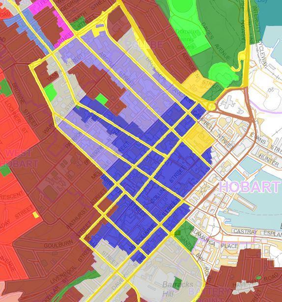
22 Figure 22.2 Central Business Zone Height Areas


23 Figure 22.3 Amenity Building Envelope Footnotes The Amenity Building Envelope has been developed with regard to heritage, streetscape and sense of scale, wind tunneling effects and solar penetration. The 20m height at the northwest/northeast facing frontages maintains a 1:1 ratio of street:building height for the purposes of townscape aesthetics and maintaining a human scale. The 15m height and subsequent 45 degree building envelope angle at southwest/southeast facing frontages maintains sufficient solar penetration to the opposite side of the street and also helps to control air and wind turbulence. The Amenity Building Envelope is shown by the thick dotted lin. The 15m setbacks for the 'steps' of development shown within the envelope are suggestive only. Development does not have to comply with the suggested 15m setbacks in order to comply with the envelope.

24 Figure 22.4 i Plan View of Permitted Development Under A4
25 Figure 22.4 ii Elevation View of Permitted Development Under A4
26 Figure 22.5 i Heritage Streetscape Standard
27 Figure 22.5 ii Heritage Streetscape Standard Height Example
28 Building Height To ensure that building height contributes positively to the streetscape and does not result in unreasonable impact on residential amenity of land in a residential zone. A1 Building height must be no more than: (a) 11.5m high and a maximum of 3 storeys; or (b) 15m high and a maximum of 4 storeys, if the development provides at least 50% of the floor space above ground level for residential use. Building height must satisfy all of the following: (a) be consistent with any Desired Future Character Statements provided for the area; (b) be compatible with the scale of nearby buildings; (c) not unreasonably overshadow adjacent public space; (d) allow for a transition in height between adjoining buildings, where appropriate; A2 Building height within 10 m of a residential zone must be no more than 8.5 m. P2 Building height within 10 m of a residential zone must be compatible with the building height of existing buildings on adjoining lots in the residential zone.
The Proposed Auckland Unitary Plan (notified 30 September 2013)
") 3 Business zones Introduction There are 10 business zones in the Unitary Plan: City Centre Metropolitan Centre Town Centre Local Centre Neighbourhood Centre Mixed Use General Business Business Park Light
3 Business zones Introduction There are 10 business zones in the Unitary Plan: City Centre Metropolitan Centre Town Centre Local Centre Neighbourhood Centre Mixed Use General Business Business Park Light
H14. Business General Business Zone
 H14. Business General Business Zone H14.1. Zone description The Business General Business Zone provides for business activities from light industrial to limited office, large format retail and trade suppliers.
22.15 OUTDOOR ADVERTISING SIGNAGE POLICY
 22.15 OUTDOOR ADVERTISING SIGNAGE POLICY This policy applies to all land where a planning permit is required to construct or display a sign under the provisions of the Kingston Planning Scheme. 22.15-1
SCHEDULE 12 TO THE DESIGN AND DEVELOPMENT OVERLAY GLEN WAVERLEY ACTIVITY CENTRE STRUCTURE PLAN
 DD/MM/YY Proposed C120 SCHEDULE 12 TO THE DESIGN AND DEVELOPMENT OVERLAY Shown on the planning scheme map as DDO12. GLEN WAVERLEY ACTIVITY CENTRE STRUCTURE PLAN 1.0 Design objectives DD/MM/YY Proposed
Section Three, Appendix 16C Medium Density Housing, Design Assessment Criteria (Residential 8A zone)
") APPENDIX 16C MEDIUM DENSITY HOUSING, DESIGN ASSESSMENT CRITERIA (RESIDENTIAL 8A ZONE) PURPOSE OF APPENDIX 16C (RESIDENTIAL 8A ZONE) In the Residential 8A Zone the following are defined as restricted discretionary
APPENDIX 16C MEDIUM DENSITY HOUSING, DESIGN ASSESSMENT CRITERIA (RESIDENTIAL 8A ZONE) PURPOSE OF APPENDIX 16C (RESIDENTIAL 8A ZONE) In the Residential 8A Zone the following are defined as restricted discretionary
H10. Business Town Centre Zone
 H10. Business Town Centre Zone H10.1. Zone description The Business Town Centre Zone applies to suburban centres throughout Auckland, the satellite centres of Warkworth and Pukekohe, and the rural towns
I615. Westgate Precinct
 I615. Westgate Precinct I615.1. Precinct Description The Westgate Precinct is located approximately 18km west of the Auckland city centre. There are seven Sub-precincts in the Westgate Precinct: Sub-precinct
Child Minding Centres and Family Day Care
 Child Minding Centres and Family Day Care Policy Type: Local Planning Policy Policy Owner: Director Urban Planning Policy No. LPP1.12 Last Review Date: 20 September 2016 Policy Objectives To provide for
H13. Business Mixed Use Zone
 H13. Business Mixed Use Zone H13.1. Zone description The Business Mixed Use Zone is typically located around centres and along corridors served by public transport. It acts as a transition area, in terms
AOTEA SUPERMARKET ZONE. Zone Introduction
 C18 AOTEA SUPERMARKET ZONE Zone Introduction C18.1 Objective This zone identifies a specific area in Aotea for a stand alone supermarket. The zone is site specific and has a range of objectives, policies
therry, elizabeth, franklin and queen: BLOCK plan
 therry, elizabeth, franklin and queen: BLOCK plan INTRODUCTION Therry, Elizabeth, Franklin and Queen Street block Purpose & background The City of Melbourne has prepared this document for developers and
Keystone Business Park Precinct Structure Plan North East Industrial Precinct. Part 2 Design Principles
 Keystone Business Park Precinct Structure Plan North East Industrial Precinct Part 2 Design Principles Context Issues Services Landform Issues Geotech and contamination Ecology Traffic and access Issues
Section Three, Appendix 17C Multiple Unit Housing Design Assessment Criteria
 APPENDIX 17C MULTIPLE UNIT HOUSING DESIGN ASSESSMENT CRITERIA Purpose of Appendix 17C In the Residential 9 Zone the construction and use of multiple household units located within the Multiple Household
H9. Business Metropolitan Centre Zone
 H9. Business Metropolitan Centre Zone H9.1. Zone description The Business Metropolitan Centre Zone applies to centres located in different subregional catchments of Auckland. These centres are second only
4 Residential and Urban Living Zones
 4 Residential and Urban Living Zones Refer to Chapters 11 to 20 for additional rules that may apply to these zones. 4.1 OBJECTIVES AND POLICIES Objective Res1 Policy 1 Policy 2 Policy 3 Policy 4 Policy
6.6.2 Emerging Community Zone Code Application Purpose and overall outcomes. s6 Zone Codes Emerging Community and Township Zone Codes
 6.6.2 Emerging Community Zone Code 6.6.2.1 Application This code applies to assessable development:- (1) within the Emerging Community Zone as identified on the zoning maps contained within Schedule 2
Chapter 13 Residential Areas: Appendices APPENDIX 1 Residential Areas
 Chapter 13 Residential Areas: Appendices Page 1 Chapter 13 Residential Areas: Appendices APPENDIX 1 Residential Areas Design Code for Intensive Housing INTRODUCTION DESIGN ELEMENTS A NEIGHBOURHOOD DESIGN
Development Control Plan
 Development Control Plan Rhodes Corporate Park (Also known as the Digital Site) Development Control Plan Date of Adoption: 4 September 2007 Effective Date: 7 March 2008 Index 1 INTRODUCTION... 3 1.1 LAND
Division 13 Local Business and Industry Buffer Zone: Assessment Criteria and Assessment Tables
 Division 13 Local Business and Industry Buffer Zone: Assessment Criteria and Assessment Tables 4.13.1 Local Business and Industry Buffer Zone The provisions in this division relate to the Local Business
open space environment
 This section updated August 09 GUIDELINE TO THE RULES The Open Space Environment Rules apply to activities on sites within the Open Space Environment as shown on the Human Environments Maps. Most of the
Division 7 Character Areas Housing Zone: Assessment Criteria and Assessment Tables
 Division 7 Character Areas Housing Zone: Assessment Criteria and Assessment Tables 4.7.1 Character Areas Housing Zone The provisions in this division relate to the Character Areas Housing Zone as follows
Cape Cabarita (Formerly known as the Wellcome Site) Development Control Plan. Date of Adoption: 4 September 2007 Effective Date: 7 March 2008
 Development Control Plan. Date of Adoption: 4 September 2007 Effective Date: 7 March 2008") Cape Cabarita (Formerly known as the Wellcome Site) Development Control Plan Date of Adoption: 4 September 2007 Effective Date: 7 March 2008 Development Control Plan Index 1 INTRODUCTION...3 1.1 LAND TO
Cape Cabarita (Formerly known as the Wellcome Site) Development Control Plan Date of Adoption: 4 September 2007 Effective Date: 7 March 2008 Development Control Plan Index 1 INTRODUCTION...3 1.1 LAND TO
H7 Open Space zones. (a) provide for the needs of the wider community as well as the needs of the community in which they are located;
 provide for the needs of the wider community as well as the needs of the community in which they are located;") H7. Open Space zones H7.1. Background The majority of land zoned as open space is vested in the Council or is owned by the Crown. However some areas zoned open space are privately owned. While the open
H7. Open Space zones H7.1. Background The majority of land zoned as open space is vested in the Council or is owned by the Crown. However some areas zoned open space are privately owned. While the open
Nelson Residential Street Frontage Guideline
 DRAFT 22-06-2012 Nelson Residential Street Frontage Guideline June 2012 1317273 Contents and purpose Residential s are important Residential s are much more than corridors which move traffic. Streets allow
SCHEDULE THREE TO THE DEVELOPMENT PLAN OVERLAY EASTERN GOLF COURSE KEY REDEVELOPMENT SITE
 DD/MM/YY SCHEDULE THREE TO THE DEVELOPMENT PLAN OVERLAY Shown on the planning scheme map as DPO3 EASTERN GOLF COURSE KEY REDEVELOPMENT SITE 1.0 A permit may be granted before a development plan has been
I539. Smales 2 Precinct
 I539. Smales 2 Precinct I539.1. Precinct Description The Smales 2 Precinct applies to a 4.8 hectare block of land located on the southern side of Northcote Road and fronting Lake Pupuke, Takapuna. The
FORMER CANADIAN FORCES BASE (CFB) ROCKCLIFFE SECONDARY PLAN. Official Plan Amendment XX to the Official Plan for the City of Ottawa
 ROCKCLIFFE SECONDARY PLAN. Official Plan Amendment XX to the Official Plan for the City of Ottawa") FORMER CANADIAN FORCES BASE (CFB) ROCKCLIFFE SECONDARY PLAN Official Plan Amendment XX to the Official Plan for the City of Ottawa 1 INDEX THE STATEMENT OF COMPONENTS PART A THE PREAMBLE PAGE Purpose...
FORMER CANADIAN FORCES BASE (CFB) ROCKCLIFFE SECONDARY PLAN Official Plan Amendment XX to the Official Plan for the City of Ottawa 1 INDEX THE STATEMENT OF COMPONENTS PART A THE PREAMBLE PAGE Purpose...
PART AOTEA PRECINCT
 CONTENTS... PAGE AOTEA PRECINCT...4 14.5.1 INTRODUCTION...4 14.5.2 RESOURCE MANAGEMENT ISSUES...4 14.5.3 RESOURCE MANAGEMENT OBJECTIVES AND POLICIES... 4 14.5.4 RESOURCE MANAGEMENT STRATEGY...5 14.5.5
I331. St John s Theological College Precinct
 I331. St John s Theological College Precinct I331.1. Precinct Description The precinct contains the existing St John s Theological College which is a residential college for the Anglican Church in New
4 RESIDENTIAL ZONE. 4.1 Background
 4 RESIDENTIAL ZONE 4.1 Background The residential areas within the City are characterised by mainly lowrise dwellings sited on individual allotments. Past architectural styles, settlement patterns and
an Inspector appointed by the Secretary of State for Communities and Local Government
 Appeal Decision Site visit made on 11 October 2016 by Mike Hayden BSc DipTP MRTPI an Inspector appointed by the Secretary of State for Communities and Local Government Decision date: 21 November 2016 Appeal
H1. Residential Large Lot Zone
 H1. Residential Large Lot Zone H1.1. Zone description The Residential Large Lot Zone provides for large lot residential development on the periphery of urban areas. Large lot development is managed to
Guidance Notes Completing an AEE
 Guidance Notes Completing an AEE The purpose of this guidance note is to assist you with completing your Assessment of Environmental Effects (AEE) for your land-use consent application. If you do not provide
6. REGIONAL AND COMMUNITY FACILITIES DESIGNATIONS 6.1. OBJECTIVES FOR REGIONAL AND COMMUNITY FACILITIES LAND USE DESIGNATIONS
 6. REGIONAL AND COMMUNITY FACILITIES DESIGNATIONS INTRODUCTION The Regional and land use designations provide the primary locations for uses which satisfy the health, education and other service needs
Perth and Kinross Council Development Management Committee 20 February 2013 Report of Handling by Development Quality Manager
 Perth and Kinross Council Development Management Committee 20 February 2013 Report of Handling by Development Quality Manager 4(4)(iii) 13/81 Erection of sports hall, associated changing facilities, offices
Contents of Part 6. Part 6 Zones
 Contents of Part 6 Part 6 Zones... 6-1 6.1 Preliminary... 6-1 6.2 Zone codes... 6-3 6.2.1 Low density residential zone code... 6-3 6.2.1.1 Application... 6-3 6.2.1.2 Purpose and overall outcomes... 6-3
Planning Committee 04/02/2015 Schedule Item 6. Smith Farm Estate, Old Bridge Close, Northolt, UB5 6UA.
 Planning Committee 04/02/2015 Schedule Item 6 Ref: Address: Ward: Proposal: PP/2014/5145 Smith Farm Estate, Old Bridge Close, Northolt, UB5 6UA. Greenford Broadway Installation of sports pitch, reconstruction
MIXED-USE ZONING DISTRICT DESIGN GUIDELINES
 MIXED-USE ZONING DISTRICT DESIGN GUIDELINES In addition to the development regulations contained in the Mixed-Use Zoning District, design guidelines are presented here to provide an added level of definition
(DC1) Direct Development Control Provision DC1 Area 4
 Direct Development Control Provision DC1 Area 4") . General Purpose (DC) Direct Development Control Provision DC Area 4 The purpose of this Provision is to provide for an area of commercial office employment and residential development in support of the
. General Purpose (DC) Direct Development Control Provision DC Area 4 The purpose of this Provision is to provide for an area of commercial office employment and residential development in support of the
Sawtell Town Centre Development Control Plan
 Sawtell Town Centre Development Control Plan ABN 79 126 214 487 CONTENTS INTRODUCTION... 1 PREAMBLE... 1 HOW TO USE THIS DCP... 1 LAND TO WHICH THIS PLAN APPLIES... 1 MASTERPLAN... 2 VISION... 2 CHARACTER
Development Control Plan
 Development Control Plan Abbotsford Cove (Also known as the Former Nestle Site) Development Control Plan Date of Adoption: 4 September 2007 Effective Date: 7 March 2008 Index 1 INTRODUCTION... 3 1.1 ENVIRONMENTAL
Division 11 Recreation and Entertainment Code
 Part 12, Div 11 Recreation and Entertainment Code Division 11 Recreation and Entertainment Code 12.11.1 Recreation and Entertainment Code (1) The provisions in this division comprise the Recreation and
Division 12 Community Use Code
 Division 12 Community Use Code 12.12.1 Community Use Code (v) provide reasonable buffers between incompatible uses and zones or Sub Areas; (1) The provisions in this division comprise the Community Use
Chapter 5 Urban Design and Public Realm
 5.1 Introduction Public realm is all areas of the urban fabric to which the public have access. It is where physical interaction takes place between people. It therefore, includes buildings and their design,
MASTER PLAN NO. 60 (SITE DEVELOPMENT PLAN EASTBANK/REGATTA NORTH PRECINCTS 2 4) 2008
 2008") Page 2 TABLE OF CONTENTS PAGE 1 PRELIMINARY... 5 1.1 CITATION... 5 1.2 TYPE OF MASTER PLAN... 5 1.3 LEGAL REQUIREMENT FOR MASTER PLAN... 5 1.4 LEGAL EFFECT OF THE MASTER PLAN... 5 2 DESCRIPTION OF LAND...
Page 2 TABLE OF CONTENTS PAGE 1 PRELIMINARY... 5 1.1 CITATION... 5 1.2 TYPE OF MASTER PLAN... 5 1.3 LEGAL REQUIREMENT FOR MASTER PLAN... 5 1.4 LEGAL EFFECT OF THE MASTER PLAN... 5 2 DESCRIPTION OF LAND...
DAREBIN PLANNING SCHEME AMENDMENT C137
 Who is the planning authority? Planning and Environment Act 1987 DAREBIN PLANNING SCHEME AMENDMENT C137 EXPLANATORY REPORT This amendment has been prepared by the Darebin City Council, who is the planning
Land Use Amendment in Southwood (Ward 11) at and Elbow Drive SW, LOC
 at and Elbow Drive SW, LOC") 2018 November 15 Page 1 of 10 EXECUTIVE SUMMARY This land use amendment application was submitted by Rick Balbi Architect on 2017 August 31 on behalf of Sable Developments Ltd, and with authorization from
2018 November 15 Page 1 of 10 EXECUTIVE SUMMARY This land use amendment application was submitted by Rick Balbi Architect on 2017 August 31 on behalf of Sable Developments Ltd, and with authorization from
Application Recommended for Approval Hapton with Park Ward
 Application Recommended for Approval Hapton with Park Ward APP/2017/0036 Outline Planning Application Outline application for the construction of a new 3 bedroom dwelling (with all matters reserved for
Division 10 Local Retail and Commercial Zone: Assessment Criteria and Assessment Tables
 Division 10 Local Retail and Commercial Zone: Assessment Criteria and Assessment Tables 4.10.1 Local Retail and Commercial Zone The provisions in this division relate to the Local Retail and Commercial
and services The protection and conservation of environmentally significant and sensitive natural heritage features and functions.
 6. Land Use 6.0 Preamble A healthy and livable city is one in which people can enjoy a vibrant economy and a sustainable healthy environment in safe, caring and diverse neighbourhoods. In order to ensure
SOUTH CAMBRIDGESHIRE DISTRICT COUNCIL. Director of Development Services
 SOUTH CAMBRIDGESHIRE DISTRICT COUNCIL REPORT TO: Development and Conservation Control Committee 5 th April 2006 AUTHOR/S: Director of Development Services S/2290/05/F Haslingfield House (Revised Design)
Design and siting guidelines
 Design and siting guidelines Enhance your lifestyle Callaway Park an development 1 These Guidelines deal with the planning and development of the vacant residential land lots at Callaway Park. 2 Introduction
Highland Village Green Design Guidelines
 Highland Village Green Design Guidelines Publishing Information Title Highland Village Green Design Guidelins Author The City of Calgary Status DRAFT - Proposed document subject to changes Additional Copies
Subdivision Design Criteria. Penihana North GUIDELINES TO THE RULES
 Created September 2013 Penihana North Subdivision Design Criteria GUIDELINES TO THE RULES This part of the Plan sets out the design criteria for subdivision in Penihana North. The criteria will be considered
Planned Development Review Revisions (Project No. PLNPCM )
") Planned Development Review Revisions (Project No. PLNPCM2014-00139) Standard residential development Planned Development Example: Smaller lot sizes than what is allowed to create open space amenity. What
Planned Development Review Revisions (Project No. PLNPCM2014-00139) Standard residential development Planned Development Example: Smaller lot sizes than what is allowed to create open space amenity. What
WELLINGTON HOSPITAL DESIGN GUIDE TABLE OF CONTENTS
 WELLINGTON HOSPITAL DESIGN GUIDE TABLE OF CONTENTS 1.0 Introduction Page 2 The Place of Wellington Hospital 2 The Future of the Hospital 2 2.0 The Intention of the Design Guide 3 3.0 Analysis 4 General
Parish of Repton NEIGHBOURHOOD DEVELOPMENT PLAN
 Parish of Repton NEIGHBOURHOOD DEVELOPMENT PLAN BASIC CONDITIONS STATEMENT December 2018 CEF 4 Legal Requirements This statement has been produced by the NDP Working Group on behalf of Repton Parish Council
Ensure that development within the Arrowtown Urban Growth Boundary provides:
 URBAN DEVELOPMENT 4 4.2.5.2 Ensure that development within the Arrowtown Urban Growth Boundary provides: an urban form that is sympathetic to the character of Arrowtown, including its scale, density, layout
Schedule of Planning Applications Committee Date: 23 May Reference: 06/17/0726/F Parish: Hemsby Officer: Mr J Beck Expiry Date:
 Schedule of Planning Applications Committee Date: 23 May 2018 Reference: 06/17/0726/F Parish: Hemsby Officer: Mr J Beck Expiry Date: 22-05-2018 Applicant: Proposal: Site: Mr Gillett Change of use to the
APPENDIX 10 THE RESIDENTIAL DESIGN GUIDE FOR DEVELOPMENTS IN RESIDENTIAL ZONES IN SPECIFIED GROWTH AREAS
 THE RESIDENTIAL DESIGN GUIDE FOR DEVELOPMENTS IN RESIDENTIAL ZONES IN SPECIFIED GROWTH AREAS ISTHMUS SECTION - OPERATIVE 1999 Page 1 CONTENTS... PAGE 1.0 INTRODUCTION... 4 1.1 Growth Management Strategy...
This table identifies new provisions sought to be added:
 Chapter 16 Business Mixed Use This table identifies new provisions sought to be added: Appellant Court Number FII Holdings Limited ENV-2018-CHC-084 FII Holdings Limited ENV-2018-CHC-084 Universal Developments
Hobart City Council. Hobart Central Area Zoning Review. Stage 5. October 2005
 Hobart City Council Hobart Central Area Zoning Review Stage 5 October 2005 Contents 1. Introduction 3 2. Development Standards 4 2.1 Definitions Required 4 2.2 Central Business Zone Development Standards
Case Officer: Sarah Kay File No: CHE/14/00515/REM Tel. No: (01246) Plot No: 2/6132 Ctte Date: 15 th September 2014 ITEM 1
 Plot No: 2/6132 Ctte Date: 15 th September 2014 ITEM 1") Case Officer: Sarah Kay File No: CHE/14/00515/REM Tel. No: (01246) 345786 Plot No: 2/6132 Ctte Date: 15 th September 2014 ITEM 1 APPROVAL OF RESERVED MATTERS FROM APPLICATION CHE/12/00234/OUT (1) LAYOUT,
Case Officer: Sarah Kay File No: CHE/14/00515/REM Tel. No: (01246) 345786 Plot No: 2/6132 Ctte Date: 15 th September 2014 ITEM 1 APPROVAL OF RESERVED MATTERS FROM APPLICATION CHE/12/00234/OUT (1) LAYOUT,
I209 Quay Park Precinct
 I209. Quay Park I209.1. Precinct description The Quay Park Precinct is located on reclaimed land at the eastern end of the city centre and along the City Centre waterfront. It is dissected to the east
Place Brief. National Collections Facility (NCF site)
") Place Brief. National Collections Facility (NCF site) Contents 1.0 Purpose 2.0 Location and Proposal 3.0 Vision and Aim 4.0 Placemaking Principles 5.0 Conclusion Plan 1 Location Plan Plan 2 Placemaking
Place Brief. National Collections Facility (NCF site) Contents 1.0 Purpose 2.0 Location and Proposal 3.0 Vision and Aim 4.0 Placemaking Principles 5.0 Conclusion Plan 1 Location Plan Plan 2 Placemaking
SUPPORTING INFORMATION
 CITY OF HOBART SUPPORTING INFORMATION CITY PLANNING COMMITTEE MEETING OPEN PORTION OF THE MEETING MONDAY, 28 NOVEMBER 2016 AT 5:00 PM VENUE: LADY OSBORNE ROOM, TOWN HALL TABLE OF CONTENTS 7.1.1 1-3 Elizabeth
SECTION 7A: WHAKARONGO RESIDENTIAL AREA
 SECTION 7A: WHAKARONGO RESIDENTIAL AREA CONTENTS 7A.1 Introduction 1 7A.2 Resource Management Issues 1 7A.3 Objectives and Policies 1 7A.4 Methods 4 7A.5 Residential Zone 4 7A.5.1 Rules: Controlled Activities
64 Mineral Extraction Area Rules
 64 Mineral Extraction Area Rules 64.1 Introduction For the purposes of this Chapter: Active Area, in relation to a Mineral Extraction Area (MEA), is that part of the Mineral Extraction Area which is owned
CONTENTS 8.0 LAND USE 8.1 GENERAL LAND USE 8.2 RESIDENTIAL 8.3 MIXED USE 8.4 COMMERCIAL 8.5 EMPLOYMENT LANDS
 8-2 Land Use 8.0 LAND USE CONTENTS 8.1 GENERAL LAND USE 8.1.1 Uses provided for in all Land Use Designations 8.1.2 Uses prohibited in Hazardous Lands, Hazardous Sites and Special Policy Areas 8.1.3 Uses
Bloor St. W. Rezoning - Preliminary Report
 STAFF REPORT ACTION REQUIRED 1638-1644 Bloor St. W. Rezoning - Preliminary Report Date: April 1, 2008 To: From: Wards: Reference Number: Toronto and East York Community Council Acting Director, Community
CA//16/00504/FUL. Canterbury City Council Military Road Canterbury Kent CT1 1YW. Crown copyright and database rights 2016 Ordnance Survey
 O Scale 1:1,250 Map Dated: 09/05/2016 CA//16/00504/FUL Crown copyright and database rights 2016 Ordnance Survey 100019614 Canterbury City Council Military Road Canterbury Kent CT1 1YW AGENDA ITEM NO 13
GREENBANK DEVELOPMENT MASTERPLAN
 DEVELOPMENT MASTERPLAN POTENTIAL TRAIN STATION COMMUNITY CENTRE Greenbank will be a connected masterplanned community providing easy access to local and surrounding amenity. Affordable quality homes, green
MASTER PLAN NO. 62 (SITE DEVELOPMENT PLAN BIRTINYA VILLAGE CENTRE) 2009
 2009") Development Agreement, Development Control Plan 1 - Kawana Waters and Section 6.1.45A (Development Control Plans under Repealed Act) of the Integrated Planning Act 1997 MASTER PLAN NO. 62 (SITE DEVELOPMENT
Development Agreement, Development Control Plan 1 - Kawana Waters and Section 6.1.45A (Development Control Plans under Repealed Act) of the Integrated Planning Act 1997 MASTER PLAN NO. 62 (SITE DEVELOPMENT
SCHEDULE 10 TO THE URBAN GROWTH ZONE. Shown on the planning scheme map as UGZ10. Truganina Precinct Structure Plan. 1.0 The Plan
 SCHEDULE 10 TO THE URBAN GROWTH ZONE Shown on the planning scheme map as UGZ10 Truganina Precinct Structure Plan 1.0 The Plan Map 1 shows the future urban structure proposed in the Truganina Precinct Structure
SITE ANALYSIS CALVARY HOSPITAL NORTH ADELAIDE LARGE INSTITUTIONS AND COLLEGES DPA CALVARY HOSPITAL
 SITE ANALYSIS Located at: 81-100 Strangways Terrace 55-79 Barnard Street 2-34 Hill Street 312-320 Ward Street HISTORY The Calvary Hospital was established in 1900 and is one of Adelaide's oldest hospitals.
Derry City and Strabane District Council Planning Committee Report
 Derry City and Strabane District Council Planning Committee Report COMMITTEE DATE: 29 th November 2017 APPLICATION No: APPLICATION TYPE: PROPOSAL: LOCATION: APPLICANT: AGENT: LA11/2016/0854/O Outline Shared
SC6.5 City Plan policy Community benefit bonus elements
 Schedule 6 City Plan policies SC6.5 City Plan policy Community benefit bonus elements SC6.5.1 Purpose The purpose of this City Plan policy is to set out when community benefit bonuses are required, as
BANKSIA GROVE DISTRICT CENTRE LOCAL STRUCTURE PLAN No. 65 PART ONE STATUTORY PLANNING SECTION
 BANKSIA GROVE DISTRICT CENTRE LOCAL STRUCTURE PLAN No. 65 PART ONE STATUTORY PLANNING SECTION This document was adopted under the Banksia Grove Agreed Local Structure Plan (21A) and Carramar South / Tapping
6.0 Land Use Policies for Rural Settlements. 6.1 Rural Settlement Strategy
 6.0 Land Use Policies for Rural Settlements 6.1 Rural Settlement Strategy INTRODUCTION AMENDMENT NO. 131 PURPOSE Designated rural settlements comprise Rural Clusters, Villages and Serviced Villages as
SOUTH CAMBRIDGESHIRE DISTRICT COUNCIL. Planning and New Communities Director. Linton. Yes
 SOUTH CAMBRIDGESHIRE DISTRICT COUNCIL REPORT TO: Planning Committee 2 July 2014 AUTHOR/S: Planning and New Communities Director Application Number: Parish(es): Proposal: Site address: Applicant(s): Recommendation:
Rural (Urban Expansion) Environment
 Environment") RUEE.1 Rural (Urban Expansion) Environment Subsequent to the receipt of appeals, a 'marked up' version of the Proposed District Plan was prepared. The provisions of the Proposed Version of the Plan subject
RUEE.1 Rural (Urban Expansion) Environment Subsequent to the receipt of appeals, a 'marked up' version of the Proposed District Plan was prepared. The provisions of the Proposed Version of the Plan subject
2A District-wide Policies
 2A Introduction This Chapter contains policies which are relevant to subdivision, use and development activities occurring across all zones and areas of the District. The policies in this Chapter implement
Development Control Plan
 Development Control Plan Liberty Grove Development Control Plan Date of Adoption: 4 September 2007 Effective Date: 7 March 2008 Index 1 INTRODUCTION... 3 1.1 NAME OF PLAN... 3 1.2 AREA TO WHICH THIS PLAN
1 The development hereby permitted shall be carried out in accordance with the following approved plans:
 Location The Avenue Tennis Club The Avenue London N3 2LE Reference: 16/6509/FUL Received: 10th October 2016 Accepted: 10th October 2016 Ward: Finchley Church End Expiry 5th December 2016 Applicant: Mrs
Rural (Urban Expansion) Environment
 Environment") RUEE.1 Rural (Urban Expansion) Environment Index RUEE.1 RUEE.1.1 RUEE.1.2 RUEE.1.3 RUEE.1.4 RUEE.2 RUEE.2.1 RUEE.2.2 RUEE.2.3 RUEE.2.4 RUEE.3 Rural (Urban Expansion) Environment Description and Expectations
RUEE.1 Rural (Urban Expansion) Environment Index RUEE.1 RUEE.1.1 RUEE.1.2 RUEE.1.3 RUEE.1.4 RUEE.2 RUEE.2.1 RUEE.2.2 RUEE.2.3 RUEE.2.4 RUEE.3 Rural (Urban Expansion) Environment Description and Expectations
4.3 Dudley Area Plan. Introduction. History and Existing Character. Desired Future Character for Dudley
 4.3 Dudley Area Plan Introduction The suburb of Dudley has developed as a result of various circumstances including its topography, history and mineral resources. Dudley development has been identified
PLANNING COMMITTEE REPORT
 PLANNING COMMITTEE REPORT TO: BY: Planning Committee South Head of Development DATE: 19 December 2017 DEVELOPMENT: SITE: WARD: APPLICATION: APPLICANT: Conversion of existing water storage reservoir to
1. General Purpose. 3. Uses
 1. General Purpose The purpose of this DC1 Provision is to facilitate the development of a pedestrian friendly Community Commercial Centre that may accommodate a range of commercial, residential, office,
3 Abbey View Mill Hill London NW7 4PB
 Location 3 Abbey View Mill Hill London NW7 4PB Reference: 15/03203/HSE Received: 26th May 2015 Accepted: 16th June 2015 Ward: Mill Hill Expiry 11th August 2015 Applicant: Proposal: Mr Richard Benson Alterations
North Oakville East Parks Facilities Distribution Plan. November, 2009
 North Oakville East November, 2009 POLICY CONTEXT 1) Purpose a) The purpose of this document is to be a guide for the location, configuration, design and development of the parks system for the North Oakville
Part 9 Specific Land Uses - Housing on Small and Narrow Lots
 19 HOUSING ON SMALL AND NARROW LOTS This section of the DCP applies where development for the purpose of a dwelling house, attached dwellings, or semi-detached dwellings is or are proposed in the R2 Low
medium desnity housing
 This section updated September 2013 This part of the Plan sets out the assessment criteria for medium density housing. The criteria are designed to give designers and builders flexibility and to provide
4.0 Design Guidelines For The Village Centre. South fields Community Architectural Design Guidelines Town of Caledon
 4.0 Design Guidelines For The Village Centre 4.0 Design Guidelines for the Village Centre The Village Centre is the focal point of the entire South Fields Community and is designed as a traditional commercial
Planning and Growth Management Committee. Chief Planner and Executive Director, City Planning Division. Pg12013 (File No NNY 34 OZ)
") 865 York Mills Road Official Plan Amendment Application Preliminary Report STAFF REPORT ACTION REQUIRED Date: February 28, 2012 To: From: Wards: Reference Number: Planning and Growth Management Committee
865 York Mills Road Official Plan Amendment Application Preliminary Report STAFF REPORT ACTION REQUIRED Date: February 28, 2012 To: From: Wards: Reference Number: Planning and Growth Management Committee
Harrow Lane, St Leonards-on-Sea, East Sussex, TN37 7JZ ERECTION OF 113 DWELLINGS TOGETHER WITH ESTATE ROADS (DETAILED SUBMISSION)
") AGENDA ITEM NO: Report to: PLANNING BOARD Date: 10 September, 2003 Report from: Borough Planning Officer Application Address: Proposal: Application No: Recommendation: Ward: File No: Applicant: Interest:
AGENDA ITEM NO: Report to: PLANNING BOARD Date: 10 September, 2003 Report from: Borough Planning Officer Application Address: Proposal: Application No: Recommendation: Ward: File No: Applicant: Interest:
Urban Design Site Assessment
 1150 Great North Road/8 Parr Road North, Point Chevalier Urban Design Site Assessment (8th February 2017) 1. Introduction and Overview 0B It is proposed to develop land at 1150/1158 Great North Road and
KWE.1 Kamo Walkability Environment
 KWE.1 Kamo Walkability Environment Index KWE.1 Kamo Walkability Environment KWE.1.1 Description and Expectations KWE.1.2 Eligibility Rule KWE.1.3 Objectives KWE.1.4 District Wide Note KAP.1 Kamo Activity
I609. Penihana North Precinct
 I609. Penihana North Precinct I609.1. Precinct description The Penihana North Precinct is located south of the Swanson Railway Station, adjacent to the Rural Urban Boundary (RUB) and Waitakere Ranges Heritage
DRAFT Northeast Quadrant of Kipling Avenue and Highway 7 DRAFT AUGUST 29, Goals Land Use. The goals of this Plan are to:
 AUGUST 29, 2017 12.15 Northeast Quadrant of Kipling Avenue and Highway 7 12.15.1 Goals 12.15.2 Land Use The goals of this Plan are to: 12.15.2.1 General Provisions: a) Ensure the development of a compact
5.1.1 The streetscape along US Highway 64 (Brevard Road); and, The built environment within new residential developments; and,
; and, The built environment within new residential developments; and,") Article 5. Landscaping 5.1 Purpose The Town of Laurel Park s landscape standards are designed to create a beautiful, aesthetically pleasing built environment that will complement and enhance community
Article 5. Landscaping 5.1 Purpose The Town of Laurel Park s landscape standards are designed to create a beautiful, aesthetically pleasing built environment that will complement and enhance community