BANKSIA GROVE DISTRICT CENTRE LOCAL STRUCTURE PLAN No. 65 PART ONE STATUTORY PLANNING SECTION
|
|
|
- Cassandra Montgomery
- 5 years ago
- Views:
Transcription
1 BANKSIA GROVE DISTRICT CENTRE LOCAL STRUCTURE PLAN No. 65 PART ONE STATUTORY PLANNING SECTION This document was adopted under the Banksia Grove Agreed Local Structure Plan (21A) and Carramar South / Tapping North Agreed Local Structure Plan (21B) and Part 9 of the City of Wanneroo District Planning Scheme No.2 and by the Western Australian Planning Commission.
2
3 RECORD OF AMENDMENTS MADE TO THE BANKSIA GROVE DISTRICT CENTRE LOCAL STRUCTURE PLAN Amendment No. Description of Amendment Final Endorsed Council
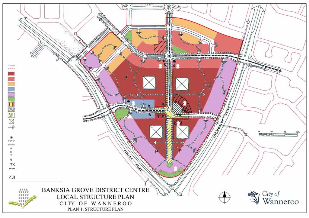
4 1.0 LOCAL STRUCTURE PLAN AREA The Local Structure Plan Area is the land contained within the inner edge of the thick red line shown on the Structure Plan Map (Plan No. 1) which includes Lot 9030 Pinjar Road, Banksia Grove and the southern portion of Lot 9021 Pinjar Road, Banksia Grove. 2.0 STRUCTURE PLAN CONTENT This Structure Plan comprises: a) Statutory section (Part 1); b) Explanatory section (Part 2); and c) Detailed Area Plans (if any). 3.0 INTERPRETATION The words and expressions used in this Structure Plan shall have the respective meanings given to them in the District Planning Scheme No. 2 (the Scheme) or, where not defined in the Scheme, as set out hereunder. The Centre shall mean the Banksia Grove District Centre. The City shall mean the City of Wanneroo. 4.0 OPERATION DATE In accordance with sub-clause of the Scheme, this Structure Plan shall come into operation on the later date when it is either certified by the Commission pursuant to sub-clause of the Scheme or adopted, signed and sealed by the Council under sub-clause of the Scheme. 5.0 RELATIONSHIP WITH THE SCHEME In accordance with clause 9.8 of the Scheme: a) The provisions, standards and requirements specified under Part 1 of this Structure Plan shall have the same force and effect as if they were provisions, standards or requirements of the Scheme. 1
5 b) In the event of there being any inconsistencies or conflict between the provisions, standards or requirements of the Scheme and the provisions, standards or requirements of this Structure Plan applicable to Zones and Residential Density Codes, then the provisions, standards or requirements of this Structure Plan shall prevail. 6.0 ZONES, RESERVES AND RESIDENTIAL DENSITY CODES The Zoning Map (Plan No. 2) and Residential Density Code Map (Plan No. 3) delineate and depict the zones, reserves and residential density codes applicable to the structure plan area according to the legend thereon. The zones, reserves and residential density codes designated apply to the land as if they were incorporated in the Scheme. All provisions, standards and requirements applicable to the zones, reserves and residential density codes in the Scheme shall apply unless specific provision is made to the contrary in this Structure Plan. 7.0 PRINCIPLES The plan is based on the following principles: A central north-south Main Street and Town Square providing an active public realm and a focus for commercial and community activity; A concentrated retail core around the Main Street and Town Square providing for a range of street-based uses; Other commercial and mixed uses extending along the Main Street alignment and cross streets, complementing the Main Street function; Medium and high density residential uses fringing the north of the Centre; Landmark building elements and location of icon buildings at key entry points to assist in legibility and creating a memorable space. 2
6 8.0 LAND USE 8.1 Land Use Precincts Land uses within the Centre shall contribute towards the provision of: Retail Core Precinct A range of retail, recreational, civic and commercial activity within the Retail Core, concentrated around the Main Street and Town Square; Interface Mixed Use and Residential Mixed Use Precincts A range of residential and complementary, lower impact commercial uses in the Interface and Residential Mixed Use precincts. As a transition zone between the Retail Core and residential areas to the north, the precincts provide for a gradual reduction of commercial activity away from the Centre core. Employment Mixed Use Precinct A range of offices, consulting rooms and mixed use around the periphery of the Main Street and Town Square within the Employment Mixed Use Precinct to provide for predominantly non-shop commercial and mixed use developments which contribute to the service and employment functions of the Centre and support the Main Street environment without undermining the concentration of activity within the core; Business Mixed Use Precinct A range of less intensive commercial activities such as showrooms and service stations along Joondalup Drive and Pinjar Road in the Business Mixed Use precinct. 8.2 Land Use Permissibility Notwithstanding the provisions of Plan No. 2 Zoning Plan, land use permissibility shall accord with the following: RETAIL CORE PRECINCT Permitted (P) Uses: Art Gallery, Bakery, Bank, Beauty Parlour, Cinema, Civic Building, Consulting Room, Corner Store, Costume Hire, Department Store*, Hairdresser, Home Business (Categories 1-3), Laundromat, Liquor Store, Lunch Bar, Medical Centre, Multiple Dwelling, Office, Pharmacy, Restaurant, Shop, Supermarket *, Take-Away Food Outlet, Theatre, Veterinary Consulting Room, Video Hire, 3
7 Discretionary (D) Uses: Aged or Dependent Persons Dwelling, Amusement Facility / Parlour, Auction Room, Child Care Centre, Club (Non Residential), Dry Cleaning Premises, Education Establishment, Grouped Dwelling, Hall, Hotel, Kindergarten, Market, Mast or Antenna, Park, Place of Assembly, Place of Worship, Private Recreation, Public Exhibition Facility, Reception Centre, Recreation Centre, Residential Building, Showroom +, Stall General, Tavern, Telecommunications Infrastructure, Veterinary Hospital Discretionary, subject to Advertising (A) Uses: Cinema Complex, Night Club MIXED USE EMPLOYMENT PRECINCT Permitted (P) Uses : Art Gallery, Bank, Beauty Parlour, Civic Building, Consulting Room, Hair Dresser, Home Business (Categories 1-3), Medical Centre, Multiple Dwelling, Office, Shop**, Veterinary Consulting Room Discretionary (D) Uses: Child Care Centre, Education Establishment, Group Dwelling, Hall, Hotel, Mast or Antenna, Park, Place of Assembly, Place of Worship, Public Exhibition Facility, Reception Centre, Recreation Centre (Fitness Centre only), Restaurant, Telecommunications Infrastructure, Veterinary Hospital INTERFACE MIXED USE PRECINCT Permitted (P) Uses: Aged or Dependent Persons Dwelling, Bank, Beauty Parlour, Consulting Room, Corner Store, Hairdresser, Home Business (Category 1-2), Laundromat, Lunch Bar, Multiple Dwelling, Office, Shop**, Veterinary Consulting Room Discretionary (D) Uses : Art Gallery, Auction Room, Bakery, Child Care Centre, Dry Cleaning Premises, Grouped Dwelling, Hall, Home Business (Category 3) Kindergarten, Mast or Antenna, Medical Centre, Park, Place of Worship, Pharmacy, Recreation Centre, Single House 4
8 Discretionary, subject to Advertising (A) Uses: Cinema, Club (Non-Residential), Reception Centre, Restaurant, Takeaway Food Outlet RESIDENTIAL MIXED USE PRECINCT Permitted (P) Uses: Aged or Dependent Persons Dwelling, Bank, Beauty Parlour, Consulting Room, Corner Store, Grouped Dwelling, Hairdresser, Home Business (Category 1), Laundromat, Multiple Dwelling, Office, Single House Discretionary (D) Uses: Art Gallery, Child Care Centre, Dry Cleaning Premises, Hall, Home Business (Category 2-3, Kindergarten, Mast or Antenna, Park, Place of Worship, Shop**, Telecommunications Infrastructure, Veterinary Consulting Room BUSINESS MIXED USE PRECINCT Permitted (P) Uses : Auction Room, Child Care Centre, Civic Building, Funeral Parlour, Home Business (Category 1-3), Kindergarten, Medical Centre, Office, Showroom, Veterinary Consulting Room Discretionary (D) Uses: Art Gallery, Bank, Car Wash, Club (Non Residential), Convenience Store, Dry Cleaning Premises, Education Establishment, Group Dwelling, Hall, Hardware Store, Laundromat, Laundry, Lunch Bar, Mast or Antenna, Multiple Dwelling, Park, Place of Assembly, Place of Worship, Plant Nursery, Private Recreation, Public Exhibition Facility, Reception Centre, Recreation Centre, Restaurant***, Service Station, Telecommunications Infrastructure, Veterinary Hospital, Video Hire * indicates in designated Large Format locations; ** indicates only in accordance with 9.2 of the Structure Plan; *** where located on an internal street (ie not on Joondalup Drive or Pinjar Road); + Small scale, consistent with Main Street form and function only. All other uses defined by the Scheme are X (not permitted). 5
9 9.0 SHOP RETAIL FLOORSPACE 9.1 Shop Retail Floorspace Volume Shopping Floorspace (as defined by the Metropolitan Centres Policy)shall be limited to 20,000m 2 NLA though retail tenancies representing an extension to Main Street and complying with Clause 9.2 below may be approved by the Council additional to this limit in accordance with Clause 5.4 of the Metropolitan Centres Policy (which allows up to 1,000m 2 NLA additional to this cap if provided in Main Street form). The 20,000m 2 is to be apportioned between the two major landowners as follows: 12,500m² Shop NLA on Lot 9102 Pinjar Road, Banksia Grove (i.e. Banksia Grove Joint Venture landholdings, as identified in the Structure Plan); and 7,500m² Shop NLA on Lot 9030 Pinjar Road, Banksia Grove (i.e. Peet Limited (as trustees for the Yatala Unit Trust), as identified in the Structure Plan). 9.2 Shop Retail Floorspace Location Shop floorspace shall be contained within the Retail Core except, at the discretion of Council, in the following circumstances: Where consistent with the definition of Showroom and Lunch Bar in the Scheme, and located in the Business Mixed Use Precinct; or Where: o o o o Shop floor area does not to exceed 100m 2 for any individual tennancy; The shop forms part of a Mixed Use development comprising a residential component equal to or greater in floor space area than the shop use; and The shop retail uses are contained within the Employment Mixed Use Precinct or the Interface Mixed Use Precinct and extend the Main Street form; and Retail uses outside the Retail Core do not cumulatively represent more than 2,500m 2 in any given year. 6
10 10.0 ACCESS 10.1 Vehicle Access Parallel on-street parking shall be provided wherever possible along the Main Street and cross-streets. A bus layover bay shall be located on the extension of Golf Links Drive into the Centre. A taxi stand shall be located on the Main Street or abutting the Community Purposes site. Vehicle access points into sites from private roads should generally be restricted to those points nominated on Plan No. 1. Temporary access may be permitted in early stages where permanent access points are not available. Street design shall accord with the Western Australian Planning Commission s Livable Neighbourhoods Policy and any relevant engineering standards Pedestrian & Cyclist Access Pedestrian and cyclist access into the Centre shall be provided in accordance with Plan No. 1 and through: The provision of on-site cycle facilities in accordance with Clause 4.16 of the Scheme; The provision of Dual Use Paths and Cycle Lanes / Paved Shoulders around the perimeter of the Centre and capacity for on-street cycling on streets through the Centre; and The provision of footpaths along all streets and abutting Internal Vehicle Connectivity routes nominated on Plan No Parking Parking provision shall be in accordance with the Scheme, though concessions may be approved where reciprocal use is provided (excluding for residential components, which must provide dedicated bays, in accordance with the R-Codes). 7
11 11.0 PARKS AND PUBLIC SPACES 11.1 Streets, Town Square and Forecourts The streets (particularly the Main Street and its southern extension) and town square are important public spaces and shall be treated as such. The southern extension of the Main Street shall provide: An integrated extension of the Main Street form and function; A high quality public space and through-route; and Good passive surveillance and security measures to allow its continued operation after dark. Smaller semi-public spaces in the form of forecourts and small squares may be provided as an entry point to buildings where they provide a high degree of pedestrian amenity, a visual focal point and entrance to the abutting building. Buildings adjoining public and semi-public spaces shall provide good passive surveillance of them through the location of significant doorways and windows (major openings) to adjoining uses. In the case of residential development, surveillance shall be provided from habitable rooms Pedestrian Routes Provision of pedestrian routes connecting the Main Street to parking areas designated on Plan 1 may be considered where: The route provides a direct and open mid-block access route from a nominated parking area to the Main Street; and Tenancies abutting both the route and the street are orient to and are provided with primary access to the street Landscape and Streetscape Design Landscaping and streetscaping within the public domain (i.e. streets, plazas and public open space) are to be of a high standard as per a Landscape and Streetscape Master Plan approved by the City prior to subdivision and / or development stage. The Plan shall establish a planting and streetscape theme for the Centre, hierarchy of spaces, palette of plants and finishes and shall nominate key features. With the exception of accent and shade trees, plants shall comprise waterwise and predominantly native 8
12 species. Landscape and streetscape design should take into account the image of the Centre, maintenance issues, water usage and hardiness. The Scheme s minimum 8% of site area landscape requirement shall not apply within the Centre. Designated drainage areas shall be developed as landscaped swales providing visual amenity in addition to their drainage function BUILDING DESIGN 12.1 Setbacks All Areas All buildings abutting a public street shall address that street and provide pedestrian access from that street; Non- Residential (Core Retail Precinct, Employment Mixed Use Precinct, Interface Mixed Use Precinct & Along Main Street) Front & Side Setbacks: Mandatory Nil except: o o Above ground floor where setbacks of up to 6m are acceptable; Where necessary to provide a forecourt (at the discretion of Council); or o To provide for a Pedestrian Route in accordance with Clause Residential (R60) Residential and Interfact Mixed Use Precincts Front Setback Minimum (m) Maximum (m) Average (m) Porch, Balcony, verandah, or the equivalent Not applicable Dwelling Not Applicable Rear Setbacks Minimum Maximum (m) Average (m) Dwelling (abutting 6.0 m laneway Dwelling (abutting 5.0m laneway) 0.5 Not Applicable Not Applicable 1.0 Not Applicable Not Applicable 9
13 Business Mixed Use Precinct Front Setback: Minimum 16.0m, Maximum 24.0m setback to Joondalup Drive and Pinjar Road to allow for interconnected parking and access. Variations to this may be applied at intersections to allow buildings u to the street to establish landmark elements Building Height Minimum two storey buildings shall be provided where nominated on Plan No Landmark Elements Primary Landmark Elements (buildings, spaces or features such as public art) shall be provided at the locations designated on Plan No. 1. These shall address the intersection on which they are located, provide a high degree of architectural quality and civic interest and, in the case of built form, be a minimum of 2 storeys in height. Secondary Landmark Elements shall be provided at key locations, as depicted on Plan No. 1. These shall generally be created through the use of massing, height and/or a pronounced architectural feature to establish a clear and attractive point of focus Fencing With the exception of residential development, no boundary fencing shall be permitted within the Centre, except where required to screen storage areas and bin enclosures. Parking areas shall not be divided by fencing, and no fencing shall interrupt vehicle and pedestrian connectivity routes (except as required under law as the minimum requirement to avoid creation of a permanent right of carriageway) Noise Attenuation Developments involving a residential component shall: Use 10mm glazing or double-glazing for all residential windows and glazed doors in facades abutting non-residential uses, the Main Street zone or other probable significant noise source; 10
14 Use appropriate materials between floors, walls, ceilings and doors to minimise noise transfer; and Make provision for air conditioning plant, and ensure that this is appropriately treated to minimise noise impact, particularly to residential areas Servicing Service goods, bin stores and drying courts, and access to these shall be provided in accordance with City of Wanneroo requirements, and shall be screened from view from public areas SUSTAINABILITY DESIGN REQUIREMENTS All development proposals (excluding change of use or minor modifications) shall: Provide plumbing installations with a minimum 5 star water efficiency rating or such other higher rating required under separate legislation; Incorporate provision for water harvesting; Be accompanied be an energy efficiency plan proposing initiatives to reduce energy requirements and emissions (eg. passive solar design, insulation, automated climate and lighting control, use of photo voltaic cells etc) BULK EARTHWORK AND DRAINAGE Site levels shall not be altered from that approved at subdivision or development stage without the prior approval of Council RESIDENTIAL DEVELOPMENTS The Mixed Use provisions of the R-Codes shall apply to residential development, except as varied by this document, including the following: Complete Site Cover is permitted (subject to provision of required Outdoor Living Areas and setbacks); Each dwelling shall be provided a useable outdoor space, a minimum of 6m 2 in area with a minimum dimension of 2m; 11
15 No communal open space is required; Walls on Boundaries may extend up to 100% along both east and west boundaries and abutting laneways at ground level and 75% above ground level (subject to compliance with front setback, truncation and other requirements);and The Privacy, Design for Climate Protection and Incidental Development provisions of the Codes pertaining to Inner-City Housing will apply in place of those applicable to Mixed Use development STAGING When each landowner makes application to construct all or any part of their retail NLA, then they must provide as part of that development, the entire Main Street within their landholding. Concurrent with the development resulting in excess of 5,000m 2 retail NLA across the whole centre: Provision (temporary or permanent) for bus services shall be made through the design of a route and bus bay(s) in consultation with the Public Transport Authority; At least 1000m 2 of non-retail commercial shall be developed within the Centre; At least 2000m 2 residential shall be developed within the Centre; At least one restaurant or tavern open after 5pm shall be developed within the Centre. Concurrent with the development resulting in excess of 10,000m 2 of retail NLA across the whole centre: At least two opposing sides of Main Street are to be developed; The Town Square and development abutting at least one side shall be constructed; At least 2000m 2 non-retail commercial shall be developed within the Centre; At least 4000m 2 residential shall be developed within the Centre; Prior to development resulting in excess of 15,000m 2 retail NLA across the whole centre: 12
16 The Community Facility must be completed (or proportionate contributions made); At least 3000m 2 non-retail commercial shall be developed within the Centre; At least 6000m 2 residential shall be developed within the Centre; At least two restaurants and / or taverns open after 5pm shall be developed within the Centre URBAN WATER MANAGEMENT PLAN Prior to the subdivision and / or development stage, an Urban Water Management Plan shall be prepared by the developer(s) to the satisfaction of the City of Wanneroo, the Department of Water and the Water Corporation of Western Australia ABORIGINAL HERITAGE SITES The Department of Indigenous Affairs (DIA) has advised that, at the development stage the developer(s) should notify the Aboriginal Community and any Native Title Claimants about the projects within the structure plan area. 13
17
18
19
I615. Westgate Precinct
 I615. Westgate Precinct I615.1. Precinct Description The Westgate Precinct is located approximately 18km west of the Auckland city centre. There are seven Sub-precincts in the Westgate Precinct: Sub-precinct
SCHEDULE 12 TO THE DESIGN AND DEVELOPMENT OVERLAY GLEN WAVERLEY ACTIVITY CENTRE STRUCTURE PLAN
 DD/MM/YY Proposed C120 SCHEDULE 12 TO THE DESIGN AND DEVELOPMENT OVERLAY Shown on the planning scheme map as DDO12. GLEN WAVERLEY ACTIVITY CENTRE STRUCTURE PLAN 1.0 Design objectives DD/MM/YY Proposed
Keystone Business Park Precinct Structure Plan North East Industrial Precinct. Part 2 Design Principles
 Keystone Business Park Precinct Structure Plan North East Industrial Precinct Part 2 Design Principles Context Issues Services Landform Issues Geotech and contamination Ecology Traffic and access Issues
H14. Business General Business Zone
 H14. Business General Business Zone H14.1. Zone description The Business General Business Zone provides for business activities from light industrial to limited office, large format retail and trade suppliers.
Contents of Part 6. Part 6 Zones
 Contents of Part 6 Part 6 Zones... 6-1 6.1 Preliminary... 6-1 6.2 Zone codes... 6-3 6.2.1 Low density residential zone code... 6-3 6.2.1.1 Application... 6-3 6.2.1.2 Purpose and overall outcomes... 6-3
I539. Smales 2 Precinct
 I539. Smales 2 Precinct I539.1. Precinct Description The Smales 2 Precinct applies to a 4.8 hectare block of land located on the southern side of Northcote Road and fronting Lake Pupuke, Takapuna. The
Chapter 13 Residential Areas: Appendices APPENDIX 1 Residential Areas
 Chapter 13 Residential Areas: Appendices Page 1 Chapter 13 Residential Areas: Appendices APPENDIX 1 Residential Areas Design Code for Intensive Housing INTRODUCTION DESIGN ELEMENTS A NEIGHBOURHOOD DESIGN
Development Control Plan
 Development Control Plan Liberty Grove Development Control Plan Date of Adoption: 4 September 2007 Effective Date: 7 March 2008 Index 1 INTRODUCTION... 3 1.1 NAME OF PLAN... 3 1.2 AREA TO WHICH THIS PLAN
FORMER CANADIAN FORCES BASE (CFB) ROCKCLIFFE SECONDARY PLAN. Official Plan Amendment XX to the Official Plan for the City of Ottawa
 ROCKCLIFFE SECONDARY PLAN. Official Plan Amendment XX to the Official Plan for the City of Ottawa") FORMER CANADIAN FORCES BASE (CFB) ROCKCLIFFE SECONDARY PLAN Official Plan Amendment XX to the Official Plan for the City of Ottawa 1 INDEX THE STATEMENT OF COMPONENTS PART A THE PREAMBLE PAGE Purpose...
FORMER CANADIAN FORCES BASE (CFB) ROCKCLIFFE SECONDARY PLAN Official Plan Amendment XX to the Official Plan for the City of Ottawa 1 INDEX THE STATEMENT OF COMPONENTS PART A THE PREAMBLE PAGE Purpose...
Clairtrell Area Context Plan
 Clairtrell Area Context Plan March 2005 Urban Development Services City Planning Contents 1. Introduction... 4 2. Development Structure... 6 2.1 Streets... 7 2.1.1 Sheppard Avenue and Bayview Avenue...
Division 13 Local Business and Industry Buffer Zone: Assessment Criteria and Assessment Tables
 Division 13 Local Business and Industry Buffer Zone: Assessment Criteria and Assessment Tables 4.13.1 Local Business and Industry Buffer Zone The provisions in this division relate to the Local Business
MASTER PLAN NO. 60 (SITE DEVELOPMENT PLAN EASTBANK/REGATTA NORTH PRECINCTS 2 4) 2008
 2008") Page 2 TABLE OF CONTENTS PAGE 1 PRELIMINARY... 5 1.1 CITATION... 5 1.2 TYPE OF MASTER PLAN... 5 1.3 LEGAL REQUIREMENT FOR MASTER PLAN... 5 1.4 LEGAL EFFECT OF THE MASTER PLAN... 5 2 DESCRIPTION OF LAND...
Page 2 TABLE OF CONTENTS PAGE 1 PRELIMINARY... 5 1.1 CITATION... 5 1.2 TYPE OF MASTER PLAN... 5 1.3 LEGAL REQUIREMENT FOR MASTER PLAN... 5 1.4 LEGAL EFFECT OF THE MASTER PLAN... 5 2 DESCRIPTION OF LAND...
(DC1) Direct Development Control Provision DC1 Area 4
 Direct Development Control Provision DC1 Area 4") . General Purpose (DC) Direct Development Control Provision DC Area 4 The purpose of this Provision is to provide for an area of commercial office employment and residential development in support of the
. General Purpose (DC) Direct Development Control Provision DC Area 4 The purpose of this Provision is to provide for an area of commercial office employment and residential development in support of the
I404 Beachlands 2 Precinct
 I404. Beachlands 2 I404.1. Precinct Description The Beachlands 2 precinct covers approximately 6 hectares of land at the corner of Beachlands and Whitford Maraetai Roads. Its purpose is to provide for
SCHEDULE THREE TO THE DEVELOPMENT PLAN OVERLAY EASTERN GOLF COURSE KEY REDEVELOPMENT SITE
 DD/MM/YY SCHEDULE THREE TO THE DEVELOPMENT PLAN OVERLAY Shown on the planning scheme map as DPO3 EASTERN GOLF COURSE KEY REDEVELOPMENT SITE 1.0 A permit may be granted before a development plan has been
4 Residential and Urban Living Zones
 4 Residential and Urban Living Zones Refer to Chapters 11 to 20 for additional rules that may apply to these zones. 4.1 OBJECTIVES AND POLICIES Objective Res1 Policy 1 Policy 2 Policy 3 Policy 4 Policy
4.0 Design Guidelines For The Village Centre. South fields Community Architectural Design Guidelines Town of Caledon
 4.0 Design Guidelines For The Village Centre 4.0 Design Guidelines for the Village Centre The Village Centre is the focal point of the entire South Fields Community and is designed as a traditional commercial
Child Minding Centres and Family Day Care
 Child Minding Centres and Family Day Care Policy Type: Local Planning Policy Policy Owner: Director Urban Planning Policy No. LPP1.12 Last Review Date: 20 September 2016 Policy Objectives To provide for
Chapter 5 Urban Design and Public Realm
 5.1 Introduction Public realm is all areas of the urban fabric to which the public have access. It is where physical interaction takes place between people. It therefore, includes buildings and their design,
Development Control Plan
 Development Control Plan Rhodes Corporate Park (Also known as the Digital Site) Development Control Plan Date of Adoption: 4 September 2007 Effective Date: 7 March 2008 Index 1 INTRODUCTION... 3 1.1 LAND
PART AOTEA PRECINCT
 CONTENTS... PAGE AOTEA PRECINCT...4 14.5.1 INTRODUCTION...4 14.5.2 RESOURCE MANAGEMENT ISSUES...4 14.5.3 RESOURCE MANAGEMENT OBJECTIVES AND POLICIES... 4 14.5.4 RESOURCE MANAGEMENT STRATEGY...5 14.5.5
ARTICLE 6: Special and Planned Development Districts
 ARTICLE 6: Special and Planned Development Districts 6-10 Traditional Neighborhood Development (TND) District 6-10.10 Purpose and Intent The Traditional Neighborhood Development (TND) District provides
Appendix D: Rockbank Major Town Centre key design principles
 Appendix D: Rockbank Major Town Centre key design principles ATTRACTING INVESTMENT & SUPPORTING THE COMMUNITY Principle 1 Create a focal point for a diverse range of uses within the town centre that are
Design and siting guidelines
 Design and siting guidelines Enhance your lifestyle Callaway Park an development 1 These Guidelines deal with the planning and development of the vacant residential land lots at Callaway Park. 2 Introduction
URBAN DESIGN BRIEF. 2136&2148 Trafalgar Road. Town of Oakville
 URBAN DESIGN BRIEF 2136&2148 Trafalgar Road Town of Oakville Prepared By: METROPOLITAN CONSULTING INC For 2500674 Ontario Inc November 2016 TABLE OF CONTENTS Page No. 1.0 Introduction/Description of Subject
WINDSOR GLEN DESIGN GUIDELINES
 WINDSOR GLEN DESIGN GUIDELINES Adopted by Council, 2006 WINDSOR GLEN REDEVELOPMENT DESIGN GUIDELINES August 2006 1.0 Master Plan Organization For this area of the Coquitlam Town Centre, a mix of high,
GREENVALE CENTRAL PRECINCT STRUCTURE PLAN
 76 Conservation area boundary. Low Fence to exclude vehicles but allow pedestrian access Front boundary of allotment 5.0m MINIMUM SETBACK Path providing public access to dwellings fronting Conservation
Melville District Centre Activity Centre Plan
 Melville District Centre Activity Centre Plan Prepared by the City of Melville 2016 In accordance with State Planning Policy 4.2: Activity Centres for Perth and Peel and the Structure Plan Framework 2015
H13. Business Mixed Use Zone
 H13. Business Mixed Use Zone H13.1. Zone description The Business Mixed Use Zone is typically located around centres and along corridors served by public transport. It acts as a transition area, in terms
URBAN DESIGN BRIEF URBAN DESIGN BRIEF 721 FRANKLIN BLVD, CAMBRIDGE August 2018
 URBAN DESIGN BRIEF URBAN DESIGN BRIEF 721 FRANKLIN BLVD, CAMBRIDGE August 2018 DESIGN BRIEF CONTENTS PART A 1.0 INTRODUCTION 2.0 DESCRIPTION & ANALYSIS OF SITE CONTEXT 3.0 DESIGN CONSTRAINTS AND OPPORTUNITIES
The Proposed Auckland Unitary Plan (notified 30 September 2013)
") 3 Business zones Introduction There are 10 business zones in the Unitary Plan: City Centre Metropolitan Centre Town Centre Local Centre Neighbourhood Centre Mixed Use General Business Business Park Light
3 Business zones Introduction There are 10 business zones in the Unitary Plan: City Centre Metropolitan Centre Town Centre Local Centre Neighbourhood Centre Mixed Use General Business Business Park Light
Urban Design Brief to 1557 Gordon Street & 34 Lowes Road West
 Urban Design Brief 1533 to 1557 Gordon Street & 34 Lowes Road West Reid s Heritage Homes Ltd. & 883928 Ontario Ltd. and RHH Property Management Ltd. City of Guelph Zoning By-law Amendment November 2017
H9. Business Metropolitan Centre Zone
 H9. Business Metropolitan Centre Zone H9.1. Zone description The Business Metropolitan Centre Zone applies to centres located in different subregional catchments of Auckland. These centres are second only
Draft Ada Street Cardiff Area Plan
 Draft Ada Street Cardiff Area Plan (Draft Amendment to Lake Macquarie Development Control Plan 2014) Exhibition: The draft Area Plan is on public exhibition from 29 February 2016 to 29 March 2016. Submissions:
H10. Business Town Centre Zone
 H10. Business Town Centre Zone H10.1. Zone description The Business Town Centre Zone applies to suburban centres throughout Auckland, the satellite centres of Warkworth and Pukekohe, and the rural towns
medium desnity housing
 This section updated September 2013 This part of the Plan sets out the assessment criteria for medium density housing. The criteria are designed to give designers and builders flexibility and to provide
Highland Village Green Design Guidelines
 Highland Village Green Design Guidelines Publishing Information Title Highland Village Green Design Guidelins Author The City of Calgary Status DRAFT - Proposed document subject to changes Additional Copies
The Village. Chapter 3. Mixed Use Development Plan SPECIFIC PLAN
 The Village SPECIFIC PLAN Chapter 3 3.1 INTRODUCTION 3.1.1 Purpose This Chapter describes the development regulations applicable to the Mixed-Use and Transit Center Planning Areas. These form-based regulations
5.1 Site Plan Guidelines
 5. Community Core Guidelines Development of the Community Core will take place by plan of subdivision and site plan approval. It will occur in a phased manner that will reflect the timing of residential
6.6.2 Emerging Community Zone Code Application Purpose and overall outcomes. s6 Zone Codes Emerging Community and Township Zone Codes
 6.6.2 Emerging Community Zone Code 6.6.2.1 Application This code applies to assessable development:- (1) within the Emerging Community Zone as identified on the zoning maps contained within Schedule 2
Melville District Activity Centre Plan
 Melville District Activity Centre Plan Prepared by the City of Melville 2016 In accordance with State Planning Policy 4.2: Activity Centres for Perth and Peel and the Structure Plan Framework 2015 1 This
Trafalgar Road Corridor Planning Study Open House
 Trafalgar Road Corridor Planning Study Open House June 24, 2013 6:30-8:30 p.m. Oakville & Trafalgar Rooms Overview The Livable Oakville Plan identifies the lands along Trafalgar Road, between the QEW and
Division 10 Local Retail and Commercial Zone: Assessment Criteria and Assessment Tables
 Division 10 Local Retail and Commercial Zone: Assessment Criteria and Assessment Tables 4.10.1 Local Retail and Commercial Zone The provisions in this division relate to the Local Retail and Commercial
Division 7 Character Areas Housing Zone: Assessment Criteria and Assessment Tables
 Division 7 Character Areas Housing Zone: Assessment Criteria and Assessment Tables 4.7.1 Character Areas Housing Zone The provisions in this division relate to the Character Areas Housing Zone as follows
DAREBIN PLANNING SCHEME AMENDMENT C137
 Who is the planning authority? Planning and Environment Act 1987 DAREBIN PLANNING SCHEME AMENDMENT C137 EXPLANATORY REPORT This amendment has been prepared by the Darebin City Council, who is the planning
DRAFT Northeast Quadrant of Kipling Avenue and Highway 7 DRAFT AUGUST 29, Goals Land Use. The goals of this Plan are to:
 AUGUST 29, 2017 12.15 Northeast Quadrant of Kipling Avenue and Highway 7 12.15.1 Goals 12.15.2 Land Use The goals of this Plan are to: 12.15.2.1 General Provisions: a) Ensure the development of a compact
Westwind Developments Ltd. PIONEER LANDS AREA STRUCTURE PLAN - PROPOSED AMENDMENT
 FEBRUARY 2013 TABLE OF CONTENTS 1.0 BACKGROUND... 1 1.1 Amendment... 1 2.0 LOCATION & CONTEXT... 2 2.1 Land Ownership... 2 3.0 POLICY CONTEXT... 3 3.1 Municipal Development Plan... 3 3.2 Capital Region
Part 9 Specific Land Uses - Housing on Small and Narrow Lots
 19 HOUSING ON SMALL AND NARROW LOTS This section of the DCP applies where development for the purpose of a dwelling house, attached dwellings, or semi-detached dwellings is or are proposed in the R2 Low
North Oakville East Parks Facilities Distribution Plan. November, 2009
 North Oakville East November, 2009 POLICY CONTEXT 1) Purpose a) The purpose of this document is to be a guide for the location, configuration, design and development of the parks system for the North Oakville
Kaufland supermarket and complementary uses, part 1550 Pascoe Vale Road, Coolaroo Incorporated Document (Insert date) 2019
 2019") Kaufland supermarket and complementary uses, part 1550 Pascoe Vale Road, Coolaroo Incorporated Document (Insert date) 2019 Page 1 of 7 Incorporated document pursuant to section 6(2)(j) of the Planning
Kaufland supermarket and complementary uses, part 1550 Pascoe Vale Road, Coolaroo Incorporated Document (Insert date) 2019 Page 1 of 7 Incorporated document pursuant to section 6(2)(j) of the Planning
Mark-up of the effect of the proposed Bronte Village Growth Area OPA No.18 on the text of section 24, Bronte Village, of the Livable Oakville Plan
 Mark-up of the effect of the proposed Bronte Village Growth Area OPA No.18 on the text of section 24, Bronte Village, of the Livable Oakville Plan Notes: This document is provided for information purposes
4.0 URBAN DESIGN FRAMEWORK. The vision for the future development of the plan area is to:
 4.0 The vision for the future development of the plan area is to: Create a new neighbourhood that focuses on the highly valued natural and aesthetic features of the lands and provides good quality homes,
APPENDIX MATAKANA COMMERCIAL URBAN DESIGN GUIDELINES
 APPENDIX MATAKANA COMMERCIAL URBAN DESIGN GUIDELINES 1.0 INTRODUCTION The following urban design guidelines are to be utilised by landowners, planners and other persons involved in development at early
I209 Quay Park Precinct
 I209. Quay Park I209.1. Precinct description The Quay Park Precinct is located on reclaimed land at the eastern end of the city centre and along the City Centre waterfront. It is dissected to the east
MASTER PLAN NO. 62 (SITE DEVELOPMENT PLAN BIRTINYA VILLAGE CENTRE) 2009
 2009") Development Agreement, Development Control Plan 1 - Kawana Waters and Section 6.1.45A (Development Control Plans under Repealed Act) of the Integrated Planning Act 1997 MASTER PLAN NO. 62 (SITE DEVELOPMENT
Development Agreement, Development Control Plan 1 - Kawana Waters and Section 6.1.45A (Development Control Plans under Repealed Act) of the Integrated Planning Act 1997 MASTER PLAN NO. 62 (SITE DEVELOPMENT
CONTENTS 8.0 LAND USE 8.1 GENERAL LAND USE 8.2 RESIDENTIAL 8.3 MIXED USE 8.4 COMMERCIAL 8.5 EMPLOYMENT LANDS
 8-2 Land Use 8.0 LAND USE CONTENTS 8.1 GENERAL LAND USE 8.1.1 Uses provided for in all Land Use Designations 8.1.2 Uses prohibited in Hazardous Lands, Hazardous Sites and Special Policy Areas 8.1.3 Uses
PORT WHITBY COMMUNITY
 PORT WHITBY COMMUNITY SECONDARY PLAN UPDATE COMMUNITY IMPROVEMENT PLAN URBAN DESIGN GUIDELINES September 2015 DRAFT PROPOSED AMENDMENT NUMBER # to the Whitby Official Plan PURPOSE: The intent of this Amendment
BYLAW C A Bylaw of Rocky View County to amend Land Use Bylaw C
 BYLAW C-7720-2017 A Bylaw of Rocky View County to amend Land Use Bylaw C-4841-97. The Council of Rocky View County enacts as follows: PART 1 TITLE This Bylaw shall be known as Bylaw C-7720-2017. PART 2
KWE.1 Kamo Walkability Environment
 KWE.1 Kamo Walkability Environment Index KWE.1 Kamo Walkability Environment KWE.1.1 Description and Expectations KWE.1.2 Eligibility Rule KWE.1.3 Objectives KWE.1.4 District Wide Note KAP.1 Kamo Activity
MASTER PLAN N0. 76 (SITE DEVELOPMENT PLAN DETAILED PLANNING AREA 12 PRECINCT 13) 2013
 2013") MASTER PLAN N0. 76 (SITE DEVELOPMENT PLAN DETAILED PLANNING AREA 12 PRECINCT 13) 2013 TABLE OF CONTENTS 1.0 ADMINISTRATION... 5 1.1 Preliminary... 5 1.2 Location and Description... 6 1.3 Zoning Map Description...
MASTER PLAN N0. 76 (SITE DEVELOPMENT PLAN DETAILED PLANNING AREA 12 PRECINCT 13) 2013 TABLE OF CONTENTS 1.0 ADMINISTRATION... 5 1.1 Preliminary... 5 1.2 Location and Description... 6 1.3 Zoning Map Description...
11.3 Steeles West Secondary Plan
 11.3 Steeles West Secondary Plan ADOPTED BY VAUGHAN CITY COUNCIL NOT YET APPROVED BY THE ONTARIO MUNICIPAL BOARD 11.3.1 Introduction This Secondary Plan recognizes that it will take a number of years for
*** DRAFT 2 FOR PUBLIC REVIEW ***
 6.7 The area is generally bounded by the Red Hill Valley Parkway to the west, Lake Avenue to the east, the Queen Elizabeth Way (QEW) to the north, and by the properties just south of Queenston Road to
I609. Penihana North Precinct
 I609. Penihana North Precinct I609.1. Precinct description The Penihana North Precinct is located south of the Swanson Railway Station, adjacent to the Rural Urban Boundary (RUB) and Waitakere Ranges Heritage
and services The protection and conservation of environmentally significant and sensitive natural heritage features and functions.
 6. Land Use 6.0 Preamble A healthy and livable city is one in which people can enjoy a vibrant economy and a sustainable healthy environment in safe, caring and diverse neighbourhoods. In order to ensure
4.3 Dudley Area Plan. Introduction. History and Existing Character. Desired Future Character for Dudley
 4.3 Dudley Area Plan Introduction The suburb of Dudley has developed as a result of various circumstances including its topography, history and mineral resources. Dudley development has been identified
The West Vaughan Employment Area Secondary Plan Policies
 Part 2: The West Vaughan Employment Area Secondary Plan Policies 2.1 General Policies It is the policy of Council: 2.1.1. That the West Vaughan Employment Area (the WVEA), identified on Schedule 1, will
1. General Purpose. 3. Uses
 1. General Purpose The purpose of this DC1 Provision is to facilitate the development of a pedestrian friendly Community Commercial Centre that may accommodate a range of commercial, residential, office,
Chapter 2: OUTLINE PLANNING APPLICATION PROPOSALS. A New Garden Neighbourhood Matford Barton 17
 Chapter 2: OUTLINE PLANNING APPLICATION PROPOSALS A New Garden Neighbourhood Matford Barton 17 2.1. SUMMARY AND STATUS OF THE PROPOSALS 2.1.1. The parameter plans and associated wording in this chapter
King s College Proposed Private Plan Change 41 Golf Avenue, Otahuhu URBAN DESIGN ASSESSMENT
 King s College Proposed Private Plan Change 41 Golf Avenue, Otahuhu URBAN DESIGN ASSESSMENT CONTENTS 1.0 EXCECUTIVE SUMMARY... 1 2.0 INTRODUCTION... 2 2.1 Purpose of document... 2 2.2 Report structure...
Appendix H: Easement cross sections
 Appendix H: Easement cross sections SHARED PATH 1.5m FOOTPATH NATURE STRIP 7.3m CARRIAGEWAY 2.7m NATURE STRIP EXISTING PIPELINE 150mm DIA 5.0m (approx.) LOCAL ACCESS ROAD EXISTING PIPELINE 500mm DIA 2.7m
RIVERSIDE DESIGN CD-1 GUIDELINES. Adopted by City Council August 9, 1983
 $1 City of Vancouver Land Use and Development Policies and Guidelines Community Services, 453 W. 12th Ave Vancouver, BC V5Y 1V4 F 604.873.7344 fax 873.7060 planning@city.vancouver.bc.ca RIVERSIDE DESIGN
BESSARION-LESLIE CONTEXT PLAN
 Development in the Bessarion-Leslie area will be consistent with the following urban design guidelines. They provide a framework for development in the area and are to be read in conjunction with the urban
Wide asphalt driveway abutting school property. garage built with incompatible materials, too close to park. incompatible fencing materials
 Wide asphalt driveway abutting school property incompatible fencing materials garage built with incompatible materials, too close to park Lack of plantings as a buffer between private property and open
Subdivision Design Criteria. Penihana North GUIDELINES TO THE RULES
 Created September 2013 Penihana North Subdivision Design Criteria GUIDELINES TO THE RULES This part of the Plan sets out the design criteria for subdivision in Penihana North. The criteria will be considered
URBAN DESIGN BRIEF Gordon Street City of Guelph. Prepared on behalf of Ontario Inc. March 25, Project No. 1507
 URBAN DESIGN BRIEF 1131 Gordon Street City of Guelph Prepared on behalf of 1876698 Ontario Inc. March 25, 2016 Project No. 1507 423 Woolwich Street, Suite 201, Guelph, Ontario, N1H 3X3 Phone (519) 836-7526
Urban Design Brief Fanshawe Park Road. Competition Toyota
 Urban Design Brief 1300 Fanshawe Park Road Competition Toyota May 2, 2014 TABLE OF CONTENTS Page No. INTRODUCTION... 1 SECTION 1 LAND USE PLANNING CONTEXT... 1 1.1 The Subject Lands... 1 1.2 The Proposal...
FRASER LANDS CD-1 GUIDELINES (BLOCKS 68 AND 69) Adopted by City Council April 1989
 Adopted by City Council April 1989") $1 City of Vancouver Land Use and Development Policies and Guidelines Community Services, 453 W. 12th Ave Vancouver, BC V5Y 1V4 F 604.873.7344 fax 873.7060 planning@city.vancouver.bc.ca FRASER LANDS CD-1
$1 City of Vancouver Land Use and Development Policies and Guidelines Community Services, 453 W. 12th Ave Vancouver, BC V5Y 1V4 F 604.873.7344 fax 873.7060 planning@city.vancouver.bc.ca FRASER LANDS CD-1
appendix and street interface guidelines
 appendix five: building and street interface guidelines appendix 5 building and street interface guidelines BOULEVARDS Boulevards are generally characterized by higher levels of traffic movement at higher
open space environment
 This section updated August 09 GUIDELINE TO THE RULES The Open Space Environment Rules apply to activities on sites within the Open Space Environment as shown on the Human Environments Maps. Most of the
Section Three, Appendix 16C Medium Density Housing, Design Assessment Criteria (Residential 8A zone)
") APPENDIX 16C MEDIUM DENSITY HOUSING, DESIGN ASSESSMENT CRITERIA (RESIDENTIAL 8A ZONE) PURPOSE OF APPENDIX 16C (RESIDENTIAL 8A ZONE) In the Residential 8A Zone the following are defined as restricted discretionary
APPENDIX 16C MEDIUM DENSITY HOUSING, DESIGN ASSESSMENT CRITERIA (RESIDENTIAL 8A ZONE) PURPOSE OF APPENDIX 16C (RESIDENTIAL 8A ZONE) In the Residential 8A Zone the following are defined as restricted discretionary
CENTRAL CITY NEIGHBORHOOD Site Plan and Design Review Guidelines Checklist
 Applicant s Name: Project Address: NEIGHBORHOOD Phone: Email: Applicant shall fill out the design guidelines checklist for all guidelines applicable to the project. Check the box if meets guideline. Indicate
Design Guidelines - 1 -
 Design Guidelines REAR YARDS Rear yard decks and porches, attached to a garden or garage suite, should be permitted provided minimum rear yard setbacks, separation distances, and necessary site access
Section 5 (S5) - Sneydes Parade
 - Sneydes Parade") EAST WERRIBEE EMPLOYMENT PRECINCT PRECINCT STRUCTURE PLAN 15m High Large Canopy Tree encouraged 41.4 6.0 4.2 2.0 0.3 300mm Kerb 3 Lane incl. dedicated bus lane 6m median (Trees at 25m spacing) 3 Lane incl.
EAST WERRIBEE EMPLOYMENT PRECINCT PRECINCT STRUCTURE PLAN 15m High Large Canopy Tree encouraged 41.4 6.0 4.2 2.0 0.3 300mm Kerb 3 Lane incl. dedicated bus lane 6m median (Trees at 25m spacing) 3 Lane incl.
6. REGIONAL AND COMMUNITY FACILITIES DESIGNATIONS 6.1. OBJECTIVES FOR REGIONAL AND COMMUNITY FACILITIES LAND USE DESIGNATIONS
 6. REGIONAL AND COMMUNITY FACILITIES DESIGNATIONS INTRODUCTION The Regional and land use designations provide the primary locations for uses which satisfy the health, education and other service needs
Cape Cabarita (Formerly known as the Wellcome Site) Development Control Plan. Date of Adoption: 4 September 2007 Effective Date: 7 March 2008
 Development Control Plan. Date of Adoption: 4 September 2007 Effective Date: 7 March 2008") Cape Cabarita (Formerly known as the Wellcome Site) Development Control Plan Date of Adoption: 4 September 2007 Effective Date: 7 March 2008 Development Control Plan Index 1 INTRODUCTION...3 1.1 LAND TO
Cape Cabarita (Formerly known as the Wellcome Site) Development Control Plan Date of Adoption: 4 September 2007 Effective Date: 7 March 2008 Development Control Plan Index 1 INTRODUCTION...3 1.1 LAND TO
East Bayshore Road Neighbourhood
 East Bayshore Road Neighbourhood Northridge Property Management Urban Design Brief 3195 East Bayshore Road City of Owen Sound January 2016 East Bayshore Road Neighbourhood Northridge Property Management
QUEEN-RIVER SECONDARY PLAN
 34 QUEEN-RIVER SECONDARY PLAN 34. QUEEN RIVER SECONDARY PLAN 1. INTRODUCTION The Queen-River area is approximately 6.4 hectares and is located at the eastern edge of the Downtown as shown on Map 34-1.
BRAMPTON FLOWERTOWN SECONDARY PLAN Area 6
 BRAMPTON FLOWERTOWN SECONDARY PLAN Area 6 October 2018 EXPLANATORY NOTES Brampton Flowertown Secondary Plan Area 6 General i. Secondary plans form part of the Official Plan and are to be read in conjunction
THE CITY OF VAUGHAN BY-LAW BY-LAW NUMBER A By-law to adopt Amendment Number 1 to the Official Plan of the Vaughan Planning Area.
 THE CITY OF VAUGHAN BY-LAW BY-LAW NUMBER 015-2014 A By-law to adopt Amendment Number 1 to the Official Plan of the Vaughan Planning Area. NOW THEREFORE the Council of the Corporation of the City of Vaughan
CITY OF FREMANTLE LOCAL PLANNING SCHEME NO. 4 AMENDMENT NO. 68 SCHEME AMENDMENT REPORT
 CITY OF FREMANTLE LOCAL PLANNING SCHEME NO. 4 AMENDMENT NO. 68 SCHEME AMENDMENT REPORT CITY OF FREMANTLE PLANNING AND DEVELOPMENT SERVICES 8 WILLIAM STREET FREMANTLE WA 6160 PLANNING AND DEVELOPMENT ACT
13 THORNHILL YONGE STREET STUDY IMPLEMENTATION CITY OF VAUGHAN OPA 669 AND TOWN OF MARKHAM OPA 154
 13 THORNHILL YONGE STREET STUDY IMPLEMENTATION CITY OF VAUGHAN OPA 669 AND TOWN OF MARKHAM OPA 154 The Planning and Economic Development Committee recommends the adoption of the recommendations contained
lot flankage Y street 16m 6m landscape strip for large site 3m landscape strip for small medium site
 Commercial General Commercial Objectives Create developments compatible with adjacent land uses in scale, function and character Define a consistent and attractive street edge with quality landscaping,
CHAPTER 21 NC-PUD NEIGHBORHOOD COMMERCIAL PUD DISTRICT
 CHAPTER 21 NC-PUD NEIGHBORHOOD COMMERCIAL PUD DISTRICT Section 21.1. Title and Purpose. The Neighborhood Commercial Planned Unit Development District, designated the, is intended for commercial uses of
GUIDELINES. Transit Oriented Development. Approved by Edmonton City Council on February 15, 2012 in tandem with City Policy C565
 Transit Oriented Development GUIDELINES Prepared by the City of Edmonton Sustainable Development and Transportation Services Departments Approved by Edmonton City Council on February 15, 2012 in tandem
AMENDMENT NO. 42 TO THE OFFICIAL PLAN OF THE TOWN OF GRIMSBY
 AMENDMENT NO. 42 TO THE OFFICIAL PLAN OF THE TOWN OF GRIMSBY INITIATED BY TOWN OF GRIMSBY TABLE OF CONTENTS PART I: THE CERTIFICATION Certification Page Adopting By-law of the Town of Grimsby PART II:
6. BUILDINGS AND SPACES OF HUMAN SCALE
 The Neighborhood Model: Building Block for the Development Areas Design Approaches 79 6. BUILDINGS AND SPACES OF HUMAN SCALE There are many elements of buildings and spaces that contribute to the creation
970 Pompton Ave, Cedar Grove, NJ Land For Sale
 Tract Size: 1.64 970 Pompton Ave, Cedar Grove, NJ Land For Sale Location: Located on busy route 23 Close to main highways 80 & 46 Asking Price: $1,500,000 Exclusive Broker: David R. Williams Senior Vice
MASTER PLAN AMENDMENT 14
 MASTER PLAN AMENMENT 14 (For advertising) Western Australian Land Authority (LandCorp) April 2016 THIS OCUMENT HAS BEEN PREPARE BY URBIS FOR LANCORP Table of Contents Amendment to the Master Plan... 1
97 Lea Bridge Road, Leyton, E10 7QL London Borough of Waltham Forest December 2015
 97 Lea Bridge Road, Leyton, E10 7QL London Borough of Waltham Forest December 2015 Public Realm and Landscape Proposals LEA BRIDGE ROAD, WALTHAMSTOW Public Realm & Landscape Proposals BDP(90)RPT001 December
4 PLACE OF WORSHIP & INSTITUTIONAL DEVELOPMENTS
 4 PLACE OF WORSHIP & INSTITUTIONAL DEVELOPMENTS OVERVIEW 1 Three main types of developments will be discussed in this section. They are: Place of Worship These include temples, churches and mosques. Civic