Sky-Terra - Project Narrative:
|
|
|
- Hubert Hensley
- 5 years ago
- Views:
Transcription
1
2
3
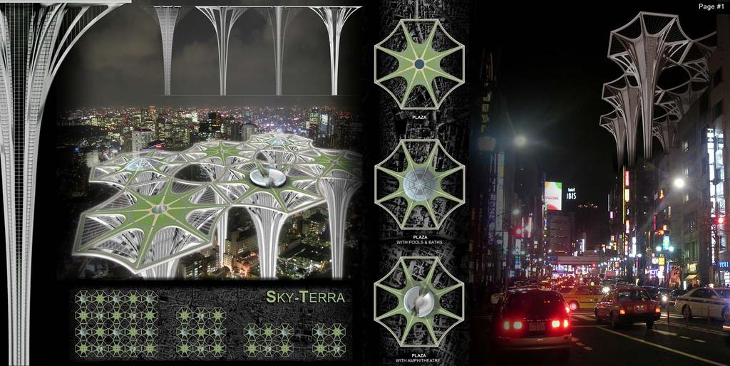
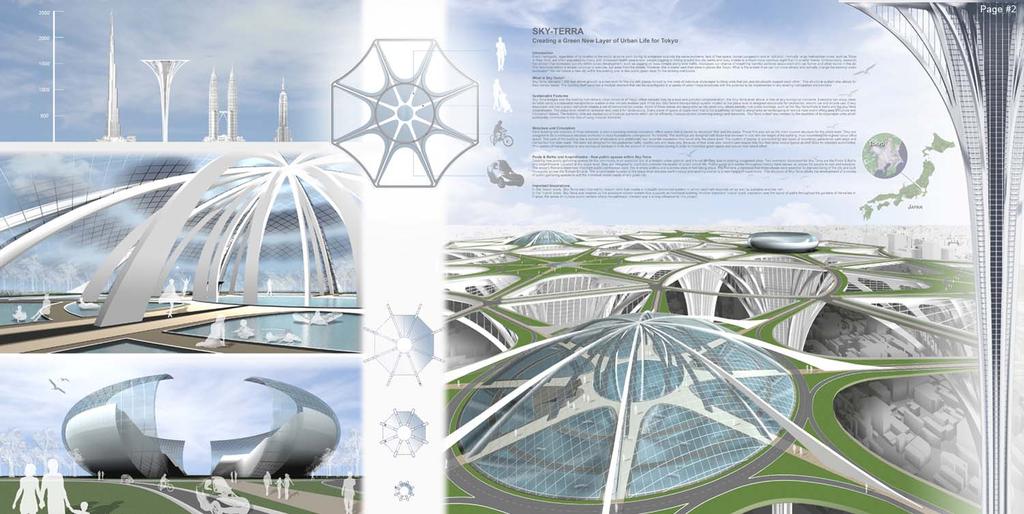
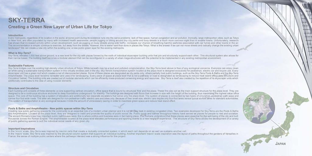
4 Sky-Terra - Project Narrative: Introduction Creating a Green New Layer of Urban Life for Tokyo Every metropolis, regardless of its location in the world, at some point during its existence runs into the same problems: lack of free space, human congestion and air pollution. Ironically, large metropolitan cities, such as Tokyo or New York, are often populated by many with increased health awareness; people jogging or biking around tiny city parks and busy streets is a much more common sight than in smaller towns. Unfortunately, research has shown that increased activity within urban development, such as jogging on busy streets alongside traffic, increases our chance of breathing harmful particles associated with car fumes and other toxins in the air. The recommendation is simple: continue to exercise, but away from the streets. However, this is easier said than done in places like Tokyo. What is the answer if we cannot move streets and radically change the existing urban landscape? We can create a new city within the existing one; a new public green layer for the existing metropolis. What is Sky-Terra? Sky-Terra, elevated 1,600 feet above ground, is a new level for the city with plazas formed by the roofs of individual skyscraper building units that join and structurally support each other. This structural system also allows for their narrow bases. The building itself becomes a modular element that can be reconfigured in a variety of urban mega-structures with the potential to be implemented in any existing metropolitan environment. Sustainable Features Sky-Terra bridges over the existing high-density urban structure of Tokyo. While beneath may be a loud and polluted conglomeration, the Sky-Terra level above is free of any ecological concerns. Everyone can enjoy clean air while using a sustainable transportation system in this virtually endless park in the sky. Sky-Terra's transportation system located at the plaza level is designed exclusively for pedestrian, electric car and bicycle use. Every skyscraper unit has a green roof which creates a net of interconnected plazas. Some of these plazas are designated as city parks only; others partially host public buildings, such as the Sky-Terra Pools & Baths and the Sky-Terra Amphitheater. The plaza level reclaims rainwater and uses it for landscaping. Every piece of space at plaza level that is not a pathway or road is designated as landscaping to reduce heat island effect (see 'Structure and Circulation' below). The building units are created out of modular elements which can be efficiently mass-produced conserving energy and resources. Sky-Terra is itself also created by the repetition of its skyscraper units which additionally contributes to the idea of using modular elements. Structure and Circulation Each building unit consists of three elements: a core supporting vertical circulation, office space that is bound by structural 'fins' and the plaza. These fins also act as the main support structure for the plaza level. They are designed to be a continuous structure anchored to deep foundations underground for stability. The buildings are designed with floors that increase in size with the height of the building, thus maximizing the highest value office space. The core of the building has a system of elevators and additionally two separate escalators that serve only the plaza level. The system of plazas is connected by two types of circulation: pedestrian path ways and narrow four foot wide roads. The latter are designed for non-pedestrian traffic: electric cars and bikes only. Because of their small size, electric cars require only four-foot lanes versus typical six-foot lanes for standard automobiles. This system of transportation is very ecological because it limits the amount of unnecessary paving in order to maximize green space and reduce heat island effect. Pools & Baths and Amphitheatre - New public spaces within Sky-Terra Creating new public gathering spaces for the community is an essential role of a modern urban planner and it is not an easy task in existing congested cities. Two examples developed for Sky-Terra are the Pools & Baths and Amphitheatre. Located at the plaza level, they are designed to instill and promote the quality of public social life. Public pools and bathes throughout history have served as places for people to rest and socialize. The ancient Romans knew how important public bathhouses were; this is where politics and business were in fact taking place. The Romans understood that these places were essential for the well-being of the city and built thousands across the Roman Empire. The amphitheater located at the plaza level elevates performance and sporting events to a new height of experience. The structure of Sky-Terra allows the development of a variety of public gathering spaces to suit the individual social needs of any given city. Important Inspirations In the 'micro' scale, Sky-Terra was inspired by neuron cells that create a mutually connected system in which each cell depends on as well as sustains another cell. In the 'macro' scale, Sky-Terra was inspired by the structural column system that supports an individual building. Another important 'macro' scale inspiration was the layout of paths throughout the gardens of Versailles in France ; the sense of multiple public centers where the pathways intersect was a strong influence for this project.
5 Sky-Terra Project Facts Sheet: Project Type: Conceptual Project Project Name: Sky-Terra Location: Tokyo (Representing a sample congested metropolis) District: Roppongi Hills Use: Public Recreation/Park/Office Stories above Ground: 100 Structure: Steel/Concrete Max. Height: Approximately 1600 Feet (Approximately 488 m) Parking Lots: Parking is not in the scope of this project Exterior Finish: Curtain Wall System Completion Period: Not Applicable (Conceptual Project created for evolo 2009 Competition)
Inspiring Technovation
 1 2 Table of content List of table and figures... Executive summary... 1. Introduction... 2. Material and methods... 3. Results... 3.1 Today s facts about Versailles: a diagnostic approach... 3.1 Vision
Welcome! to Keller Town Hall
 Welcome! to Keller Town Hall Keller Town Center Planning a New Downtown What is Keller Town Center? A new, growing downtown district planned as an urban village A combination of retail and office spaces,
/05 Architectural Response
 /05 Architectural Response 5.1 Inspiration Stacked Boxes (Artist : Rachael Whiteread) Cubism ( Architect : Le Corbusier) 52 1133 Melville Rezoning Submission Patterns ( Textile Artist : Annie Albers) Overlapping
WHAT WE HEARD REPORT - Summary Bonnie Doon Mall Redevelopment Application (LDA )
") WHAT WE HEARD REPORT - Summary Bonnie Doon Mall Redevelopment Application (LDA18-0184) PROJECT ADDRESS: 1 Bonnie Doon Shopping Centre NW, 8420 85 Street NW & 8715 85 Street NW PROJECT DESCRIPTION: Rezoning
WHAT WE HEARD REPORT - Summary Bonnie Doon Mall Redevelopment Application (LDA18-0184) PROJECT ADDRESS: 1 Bonnie Doon Shopping Centre NW, 8420 85 Street NW & 8715 85 Street NW PROJECT DESCRIPTION: Rezoning
FACT SHEET: COMMUNITY INPUT S IMPACT ON THE DESIGN FOR THE OBAMA PRESIDENTIAL CENTER
 FOR IMMEDIATE RELEASE January 10, 2018 Contact: Kate Berner, kberner@skdknick.com FACT SHEET: COMMUNITY INPUT S IMPACT ON THE DESIGN FOR THE OBAMA PRESIDENTIAL CENTER Since announcing initial plans in
Transport Demand Management (TDM) Policies and Measures for Sustainable Cities
 Policies and Measures for Sustainable Cities") 1 Intergovernmental 11 th Regional Environmentally Sustainable Transport (EST) Forum in Asia 2-5 October 2018, Ulaanbaatar, Mangolita Transport Demand Management (TDM) Policies and Measures for Sustainable
1 Intergovernmental 11 th Regional Environmentally Sustainable Transport (EST) Forum in Asia 2-5 October 2018, Ulaanbaatar, Mangolita Transport Demand Management (TDM) Policies and Measures for Sustainable
4 C OMMUNITY D ISTRICTS
 4 C OMMUNITY D ISTRICTS N ew development in the Area will include many different types of land uses, including a destination retail area that attracts people from all over the region; recreation opportunities
CHAPTER 3 VISION, GOALS, & PLANNING PRINCIPLES. City of Greensburg Comprehensive Plan. Introduction. Vision Statement. Growth Management Goals.
 CHAPTER 3 VISION, GOALS, & PLANNING PRINCIPLES Introduction The Greensburg Comprehensive Plan is intended as a working community document. A combination of long and short-term goals, this document is intended
Parker Pine Curve Master Plan January 28th, 2009, Public Workshop Comments
 Group 1 Big Ideas Pedestrian friendly within and to development - bridge over Main Street from downtown. Campus feel. Parking garage like Castle Rocks - Taj garage may be tucked in hillside. Large (big
Lambeth Main Street Streetscape Improvements
 Lambeth Main Street Streetscape Improvements Open House October 5th, 2017 Agenda 1. Introduction 2. Project Background 3. Context 4. Project Objectives 5. Design Principles & Approach 6. Streetscape Design
CITY OF KEIZER MASTER PLAN APPLICATION & INFORMATION SHEET
 CITY OF KEIZER MASTER PLAN APPLICATION & INFORMATION SHEET PRE-APPLICATION CONFERENCE Prior to the actual filing of a Master Plan application, it is strongly recommended that the applicant contact Planning
Town of Portola Valley General Plan. Nathhorst Triangle Area Plan
 Town of Portola Valley General Plan Amended December 10, 1997 Table of Contents Introduction... 1 Planning Area... 1 Objectives... 2 Principles... 2 Standards... 4 Description... 4 Community Commercial...
Onondaga County Sustainable Streets Project. Onondaga County Planning Federation June 7, Onondaga County Sustainable Streets Project 1
 Onondaga County Sustainable Streets Project Onondaga County Planning Federation June 7, 2012 Onondaga County Sustainable Streets Project 1 Sustainable Streets 1. Introduction to the SMTC 2. Sustainable
Copake Hamlet Plan: Visioning Workshop
 Copake Hamlet Plan: May 2-3 rd 2015 Hamlet Revitalization Task Force Jeffrey Nayer, Town Supervisor Jeanne Mettler, Town Board Chris Quinby Peggy Lewis Jennifer Redman Roberta Roll John Pollok Russ Davis
Community Co-Design Process. Create the ability to house a large school on the Cubberley site in the future.
 Community Co-Design Process Create the ability to house a large school on the Cubberley site in the future. Process timeline Programming Phase Design Phase M1 Program Needs & Major Spatial Relationships
A VISION FOR ST DAVIDS. Agreed by the community at the SDRBA meeting on Monday 22 nd March 2004 at Exeter Community Centre
 A VISION FOR ST DAVIDS Agreed by the community at the SDRBA meeting on Monday 22 nd March 2004 at Exeter Community Centre This Vision Statement has been prepared after consultation with the residents,
PUBLIC RIGHT-OF-WAY IN THIS CHAPTER PUBLIC REALM
 PUBLIC RIGHT-OF-WAY This section provides design guidelines for improvements in the public right-of-way. The public right-of-way refers to streets, sidewalks, non-vehicular thoroughfares, parks and greenways
Don Mills Crossing Study and Celestica Lands Development Application Community Meeting, Open House, and Breakout Discussions
 Consultation Summary Don Mills Crossing Study and Celestica Lands Development Application Community Meeting, Open House, and Breakout Discussions This report is not intended to provide a verbatim transcript
High-Density, Mixed-Use Developments and the Guiyang Riverside Theatre Project. Greg Yager, Senior Vice President, RTKL
 High-Density, Mixed-Use Developments and the Guiyang Riverside Theatre Project Greg Yager, Senior Vice President, RTKL HIGH-DENSITY, MIXED-USE DEVELOPMENT AND THE GUIYANG RIVERSIDE THEATER PROJECT CTBUH
Bethesda Downtown Plan
 Bethesda Downtown Plan Planning Board Update Connecticut Avenue Location Economic Sustainability Social Environmental Scope Coming Soon! Team Listening, Twitter Outreach We Are Here Engagement Challenge
Centennial Hall Planning Comments Public Meetings, 9/19/2011. General Comments
 Centennial Hall Planning Comments Public Meetings, 9/19/2011 General Comments Space/Location Too tight. Acquire more space (Women s Club?) Is there a more central visitor center site? Site very important
Sheridan Boulevard S TAT I O N A R E A P L A N S H E R I D A N B O U L E VA R D S TAT I O N A R E A P L A N
 Sheridan Boulevard S TAT I O N A R E A P L A N 1 City of Lakewood Adopted November, 2006 S H E R I D A N B O U L E VA R D S TAT I O N A R E A P L A N The Vision The City of Lakewood s overall vision is
LOS ANGELES MISSION COLLEGE MASTER PLAN Master Plan DESIGN & DEVELOPMENT PRINCIPLES
 LOS ANGELES MISSION COLLEGE MASTER PLAN DESIGN & DEVELOPMENT PRINCIPLES 34 Quality Learning Along the Arroyo PROGRAM SUMMARY BY PROJECT The following are program summaries for each of the projects planned
Olde Towne Vision Plan
 Olde Towne Vision Plan Introduction In 2016, the City of Bellevue will complete its move of City offices from Olde Towne Bellevue to its new municipal complex on Wall Street. The City intends to sell its
Welcome. Walk Around. Talk to Us. Write Down Your Comments
 Welcome This is an information meeting introducing the applications for proposed redevelopment of the Yorkdale Shopping Centre site at 3401 Dufferin Street and 1 Yorkdale Road over the next 20+ years,
Bridgeland-Riverside
 Active Neighbourhoods ridgeland-iverside s D FO O A IL NOH N F W N O S 8 H NU AV 1 S O M C A M P L L S H I L L N A U A L P A K U N AV 12 H S C 4 H S C S C N H I G H S S AIL th D 9 D MO N ON C K Y C A L
include playgrounds, sports fields, community gardens and picnic areas.
 DEVELOPMENT PLAN OPEN SPACE SYSTEM OPEN SPACE SYSTEM The neighborhood provides for a range of open space types. The Village Square is an important open space in the neighborhood. It serves as a gathering
RA1.01. Project Description:
 Project Description: Designed around a philosophy of "healthy building for healthy bodies," the University s recreation center inspires personal health and wellness. As the University s campus continues
Metro. Activity Center Design Guidelines. Recommendations For Developing Focused, Mixed-Use Commercial/Residential Centers
 Metro Activity Center Design Guidelines Recommendations For Developing Focused, Mixed-Use Commercial/Residential Centers Metro Activity Centers What is a MAC? Legacy, the adopted guide for the future growth
4-Town Comprehensive Plan DRAFT 7/30/07
 4-Town Comprehensive Plan DRAFT 7/30/07 Acknowledgements ning Committee Town of Harrisburg Norman Roof Randy Nicol Town of Martinsburg Terry Thisse Paul Kelly Town of Montague Jan Bagdanowicz Wendy Perry
Index 1-SETTLEMENT 2-RURAL SETTLEMENTS: (VILLAGES) 3-URBAN AREAS: (TOWNS) 3.1-TOWN FUNCTIONS 3.2-TOWN'S HIERARCHY 3.3-STRUCTURE OF TOWNS
 3-URBAN AREAS: (TOWNS) 3.1-TOWN FUNCTIONS 3.2-TOWN'S HIERARCHY 3.3-STRUCTURE OF TOWNS") TOWNS Index 1-SETTLEMENT 2-RURAL SETTLEMENTS: (VILLAGES) 3-URBAN AREAS: (TOWNS) 3.1-TOWN FUNCTIONS 3.2-TOWN'S HIERARCHY 3.3-STRUCTURE OF TOWNS 3.4-PARTS OF THE TOWN 4-URBAN PROBLEMS 5. EXERCISES 1-SETTLEMENT
TOWNS Index 1-SETTLEMENT 2-RURAL SETTLEMENTS: (VILLAGES) 3-URBAN AREAS: (TOWNS) 3.1-TOWN FUNCTIONS 3.2-TOWN'S HIERARCHY 3.3-STRUCTURE OF TOWNS 3.4-PARTS OF THE TOWN 4-URBAN PROBLEMS 5. EXERCISES 1-SETTLEMENT
Subcampus Recommendations
 T he campus is is comprised of three major areas. These subcampus areas are known as WestCampus, South Campus, Campus Oakland and Drive East Campus. and Future East growth Campus. requires a Future careful
PINE CURVE REZONING. Property does not meet criteria for open space preservation and is not a candidate for a park
 PINE CURVE REZONING BACKGROUND Purchased as two parcels in 2001 and 2002 Annexed and Zoned Greater Downtown District Historic Center September 25, 2002 and October 7, 2002 WHAT THE PROJECT IS AND IS NOT
The following principles guide the development of goals and strategies to protect and promote these amenities:
 OPEN SPACE/PARKS/TRAILS/RECREATION GOALS/STRATEGIES Cherry Hills Village is a living environment that offers low density development, open areas, public scenic vistas, public trails and public parks. This
FRUITVALE TRANSIT VILLAGE (Phase 2) Residential Project
 Residential Project") FRUITVALE TRANSIT VILLAGE (Phase 2) Residential Project DEVELOPER: SIGNATURE PROPERTIES ARCHITECT: HKIT ARCHITECTS April 23, 2010 TABLE OF CONTENTS 3 Vision 4 Description of Site 5 Guiding Concepts 6
FRUITVALE TRANSIT VILLAGE (Phase 2) Residential Project DEVELOPER: SIGNATURE PROPERTIES ARCHITECT: HKIT ARCHITECTS April 23, 2010 TABLE OF CONTENTS 3 Vision 4 Description of Site 5 Guiding Concepts 6
Market Place Bythell Place Queen Street Park Riverside Park. Public Spaces. Blenheim CBD Streetscape Final Report 36
 37 39 41 43 Market Place Bythell Place Queen Street Park Riverside Park Final Report 36 Market Place Market Place is a key space for Blenheim s street life, it is a meeting place, retail edge and pedestrian
II. SINGLE FAMILY RESIDENTIAL
 II. SINGLE FAMILY RESIDENTIAL Castle Rock is made up of numerous individually built houses and subdivision tracts that have been developed during the past century. Some of the tracts are diverse in architectural
Courthouse Square Planning & Urban Design Study. Courthouse Square Working Group #13 October 15, 2014
 Courthouse Square Planning & Urban Design Study Courthouse Square Working Group #13 October 15, 2014 1 Courthouse Square Process Working Group Community Courthouse Square Advisory Groups & Civic Associations
Allen Street Civic District Redevelopment Area Plan Redevelopment Plan & Proposal State College Planning Commission State College Redevelopment
 Allen Street Civic District Redevelopment Area Plan Redevelopment Plan & Proposal State College Planning Commission State College Redevelopment Authority September 17, 2015 Discussion Points Overview of
Design Standards. Green Development. Shadow Studies. Standards. July 2010 Updated October 2014
 Urban Design Design Standards Urban Standards July 2010 Updated October 2014 Green Development Shadow Studies Standards Table of Contents 1 Introduction 1.1 Purpose. 6 1.2 Preface.. 7 2 LID Stormwater
Transportation. Strategies for Action
 Transportation A major priority for the Overlake Neighborhood is to develop a multimodal transportation system. To achieve this system, a balance has to be found among travel, circulation and access needs;
York Road Arial View
 Arial View Bridge Ave YORK ROAD THE SITE TODAY View west down View west from View east The 1.5 ha site is located south of the and to the east of Queen Street. The site includes an existing car park, disused
URBAN DESIGN BRIEF. 2136&2148 Trafalgar Road. Town of Oakville
 URBAN DESIGN BRIEF 2136&2148 Trafalgar Road Town of Oakville Prepared By: METROPOLITAN CONSULTING INC For 2500674 Ontario Inc November 2016 TABLE OF CONTENTS Page No. 1.0 Introduction/Description of Subject
February 13, Dear Planning and Zoning Commissioners,
 Planning and Zoning Commission City of Boise 150 North Capitol Blvd Boise, ID 83702 Re: 6012 N Pierce Park Lane - S0619212608 6050 N Pierce Park Lane - S0619212608 February 13, 2015 Dear Planning and Zoning
PROJECT NARRATIVE STATEMENT OF JUSTIFICATION. Special Use Permit Modification Application
 PROJECT NARRATIVE AND STATEMENT OF JUSTIFICATION Special Use Permit Modification Application For: Facility Expansion 1602 East Franklin Street Chapel Hill, NC PIN #9799-14-1643 Applicant: SHC Construction
5 DESIGN DEVELOPMENT 5.1 ORGANIZATION OF SPACE. Projects, due to their programmatic adversity and complexity, function as small cities.
 5 DESIGN DEVELOPMENT IN THE ARCHITECTURE OF SPATIAL POSSIBILITY, ARCHITECTURE IS USED TO PROVIDE A SPATIAL FRAMEWORK THAT IS CAPABLE OF ABSORBING CHANGE, ACTING AS A HOLDING STRUCTURE TO DEFINE THE PARK
A. INTRODUCTION B. PROJECT LOCATION
 Chapter 1: Project Description A. INTRODUCTION The Lower Manhattan Development Corporation (LMDC), a subsidiary of the New York State Urban Development Corporation, doing business as the Empire State Development
Vehicle Detection. Brief history of each detection. How they work. Discuss most used ones. Are other options
 Vehicle Detection Brief history of each detection How they work Discuss most used ones Are other options What are detectors used for? Signalized Intersection Basic signal detection Vehicular presence (stop
ALTERNATIVES. NCDOT made an early decision to first determine how to build the project (construction method) followed by what to build (alternatives).
 followed by what to build (alternatives).") III. ALTERNATIVES A. CONSTRUCTION METHOD ALTERNATIVES NCDOT made an early decision to first determine how to build the project (construction method) followed by what to build (alternatives). One of the
III. ALTERNATIVES A. CONSTRUCTION METHOD ALTERNATIVES NCDOT made an early decision to first determine how to build the project (construction method) followed by what to build (alternatives). One of the
Health and the Built Environment Placemaking Workshop, February 2018
 Health and the Built Environment Placemaking Workshop, February 2018 Vermont Department of Health Suzanne Kelley; Healthy Communities Program Coordinator Vision: Healthy People in Healthy Communities As
SOUTH UNIVERSITY Street Design Setting a Direction for Schematic Design
 1 SOUTH UNIVERSITY Street Design Setting a Direction for Schematic Design Meeting Agenda 2 1. Project Scope 2. Design Direction 3. Design Details 4. Schedule and Construction Logistics 3 SOUTH UNIVERSITY
appendix and street interface guidelines
 appendix five: building and street interface guidelines appendix 5 building and street interface guidelines BOULEVARDS Boulevards are generally characterized by higher levels of traffic movement at higher
New Town Mixed Use District
 New Town Mixed Use District Montgomery County Planning Commission 2009 Annual Conference PA Chapter of the American Planning Association October 6, 2009 What is NTMU? More urban style of development Complementary
EcoVerde MADISON TO DOWNTOWN TO BEACH. Legend Highway Major Connection Major Street Local Street Proposed Access. Response to Tropicana Field RFP
 EcoVerde TO BEACH 275 16th Street North 16th Street South 13th Street North 13th Street South 11th Street North 11th Street South 1st Avenue North Central Avenue 1st Avenue South TO DOWNTOWN 2nd Avenue
CITY OF BOYNTON BEACH SE 1 ST STREET COMPLETE STREETS IMPROVEMENTS
 CITY OF BOYNTON BEACH SE 1 ST STREET COMPLETE STREETS IMPROVEMENTS N Project Location -Town Square -Villages at Ocean SE 1st St, between E Woolbright Rd and SE 2nd Ave Project Location -Boynton One -Publix
The Wildflower Property
 Jonathan Kolbe, FRSA The Wildflower Property An inclusive alternative Table of Contents Table of Figures... 2 Background... 3 Location... 3 Purpose... 3 Existing Conditions... 3 Silver Palm Park... 3 The
Schedule B to Report PLS
 Page 25 Q1. The land use concept is made up of many different land uses (residential, commercial, parks, schools, environmental areas etc.) A number of land uses are concentrated in the Community Core,
SECTION TWO: Urban Design Concepts
 SECTION TWO: Urban Design Concepts The Gardnerville Plan for Prosperity shapes economic opportunities presented by regional growth. The Urban Design Concepts provide policies and concepts for land use,
City of Farmington. Downtown Plan. Amendment to the 1998 Master Plan Adopted October 11, 2004
 City of Farmington Amendment to the 1998 Master Plan Adopted October 11, 2004 Introduction Planning Background 1 Scope and Components of the Plan Amendment 2 Concept Introduction 3 Plan Concepts 3 Conceptual
Standards (R-3) Figure B-11: R-3 Residential Standards Exhibit
 Figure B-11: R-3 Residential Standards Exhibit") Avila Ranch Avila Ranch Specific Plan Development Standards High Medium Density - High Residential Density Residential Lot and Building Lot and Standards Building (R-3) Standards (R-3) EXAMPLES These sketches
Avila Ranch Avila Ranch Specific Plan Development Standards High Medium Density - High Residential Density Residential Lot and Building Lot and Standards Building (R-3) Standards (R-3) EXAMPLES These sketches
PINE CURVE REZONING. BACKGROUND Purchased as two parcels in 2001 and 2002
 BACKGROUND Purchased as two parcels in 2001 and 2002 WHAT THE PROJECT IS AND IS NOT A Rezoning establishes the land use standards for Annexed and Zoned Greater Downtown District Historic Center September
SYRINGA VALLEY SPECIFIC PLAN NARRATIVE
 SYRINGA VALLEY SPECIFIC PLAN NARRATIVE Introduction With this application, Pleasant Valley South LLC ( Pleasant Valley ) seeks the City of Boise s approval of a new Specific Plan Ordinance to be added
Neighborhood Districts
 NEIGHBORHOOD DISTRICTS SEVEN MAIN DISTRICTS Neighborhood Districts While the Development Plan provides a broad-scale overview of the neighborhood, this section focuses on uses and relationships at the
Chapter 6--Urban Design
 6.1 Introduction... 6-1 6.1.1 Background & Scope... 6-1 6.1.2 Relationship to State Law... 6-2 6.1.3 Relationship to Other General Plan Chapters... 6-2 6.2 Guiding Principles... 6-2 6.3 Urban Design Guidelines...
NATICK COMPREHENSIVE MASTER PLAN. Natick Center Outreach Meeting. After presentations about the Natick Master Plan process, town staff and
 Meeting Notes After presentations about the Natick 2030+ Master Plan process, town staff and consultants from Crosby, Schlessinger and Smallridge posed questions to the audience. Responses are cataloged
Creating Quality Places: Successful Communities by Design
 Creating Quality Places: Successful Communities by Design Communities across the metropolitan Kansas City area are growing. Our challenge is to shape future development in ways that will maintain and enhance
The River Hub: NEW BUILDINGS
 Summary The River Hub includes 6 municipalities that all boarder the Fraser River. Combined, they are expected to double in population over the next 50 years. To accommodate this new population, 138,831
Pine Island Road Corridor Master Plan
 RECOMMENDED DEVELOPMENT PLAN Figure 9: Del Prado Village District Conceptual Framework The Conceptual Framework (Figure 8) for development of the Pine Island Corridor is to encourage mixed-use development
The Process. Phase 1: Detailed Assessment, Design Framework Phase 2: Conceptual Design. Phase 3: Master Plan Document
 Background The Ship Point master planning process was initiated in March of 2017 to advance policy direction from Harbour Vitality Principles (2014) Ship Point design and initial implementation a key action
Description of Preferred Alternative
 Chapter 2 Description of Preferred Alternative 2.1 Introduction This chapter of the programmatic Sammamish Town Center Sub-area Plan Final EIS provides a more detailed description of the Preferred Alternative
Amar City of Joy : Kolkata
 Cultural Capital of India City of All Cities City of Football in India Amar City of Joy : City of Bridges in India City of Palaces Literary Capital of India Paris of the East City of Furious Creative Energy
Achieving a Vision. Master Plan 2009 Belknap Campus August 10 11, UofL Belknap Campus Master Plan Update
 Achieving a Vision Master Plan 2009 Belknap Campus August 10 11, 2009 Consultant Team The Campus Studio Ann Arbor Michigan Team Leader Campus Planning Site Design JRA Architects Louisville Kentucky Assistant
Guiding Principles for the SR 520 Replacement Project
 Guiding Principles for the SR 520 Replacement Project Presentation to the Board of Regents Theresa Doherty Assistant Vice President for Regional Affairs May 18, 2006 F-14 The University of Washington is
SPEECH BY MINISTER OF STATE FOR NATIONAL DEVELOPMENT, DR KOH POH KOON, AT THE MEGACITIES THINK TANK ALLIANCE FORUM, 12 JULY 2016, SINGAPORE
 SPEECH BY MINISTER OF STATE FOR NATIONAL DEVELOPMENT, DR KOH POH KOON, AT THE MEGACITIES THINK TANK ALLIANCE FORUM, 12 JULY 2016, SINGAPORE A very good afternoon Members of the Megacity Think Tank Alliance,
1.0 Introduction. Purpose and Basis for Updating the TMP. Introduction 1
 1.0 Introduction The Town of Castle Rock is situated between the metropolitan areas of Denver and Colorado Springs, amidst a unique terrain of rolling hills, mesas, ravines, and waterways. Like many Front
Stakeholders Advisory Working Groups (SAWGs) Smart Growth and TOD Land Use (#11) SAWG Meeting
 Smart Growth and TOD Land Use (#11) SAWG Meeting") Presentation - Part II Tappan Zee Bridge/I-287 Corridor Project July 21, 2010 Slide 1. David Kooris (Regional Plan Association) welcomed members of the Land Use Stakeholders Advisory Working Groups (SAWGs)
Presentation - Part II Tappan Zee Bridge/I-287 Corridor Project July 21, 2010 Slide 1. David Kooris (Regional Plan Association) welcomed members of the Land Use Stakeholders Advisory Working Groups (SAWGs)
DOWNTOWN GEORGETOWN PLANNING STUDY
 DOWNTOWN GEORGETOWN PLANNING STUDY Community Workshop #3 Thursday, May 4, 08 The Planning Partnership OVERVIEW OF STUDY, PROCESS & MILESTONES We are here PURPOSE OF THE STUDY To develop a clear vision
greenprint midtown SUSTAINABILITY ACTION PLAN 2012
 greenprint midtown SUSTAINABILITY ACTION PLAN 2012 MIDTOWN ALLIANCE SOUTHFACE ENERGY INSTITUTE RENAISSANCE PLANNING GROUP SUSTAINABLE ATLANTA PERKINS+WILL 2 GREENPRINT MIDTOWN 1. Introduction Sustainability
Nu Skin Innovation Center. Location: Provo, Utah Lot Size: 435,600 GSF Building Size: 168,000 GSF Project Type: Commercial LEED Gold Certified
 Nu Skin Innovation Center Location: Provo, Utah Lot Size: 435,600 GSF Building Size: 168,000 GSF Project Type: Commercial LEED Gold Certified The Nu Skin Innovation Center transforms Nu Skin Enterprises
From the site planning and design perspective, the challenge is to
 Site Design and Its Relation to Urban Form MICHAEL V. DYETT Blayney Dyett Greenberg, San Francisco, California From the site planning and design perspective, the challenge is to heighten awareness of how
Introduction. Community Outreach Approach. Sacramento Valley Station Master Plan. Online Questionnaire Summary of Feedback.
 Introduction Located in the northwest sector of downtown Sacramento, the Sacramento Valley Station (SVS) is the primary rail station in northern California and the seventh busiest station in the country.
Table of Contents. Elm Avenue Improvement Plan City of Waco, Texas. Introduction 1. Existing Context 1 Figure 1 2.
 Table of Contents Introduction 1 Existing Context 1 Figure 1 2 Plan Guidelines 3 Future Urban Form 4 The West-End 4 Main Street 6 The East-End 7 Figure 2 9 Public Improvement Recommendations 7 General
Public input has been an important part of the plan development process.
 Lakewood s Comprehensive Plan recognizes that transportation helps shape the community, and that the way the community provides for the safe and efficient movement of people affects the character of the
MAIN STREET ECONOMIC DEVELOPMENT STRATEGY
 MAIN STREET ECONOMIC DEVELOPMENT STRATEGY A PATHWAY TO A BETTER POUGHKEEPSIE DRAFT Working Paper #2: Planning Strategies Submitted December 1 st, 2015 to the City of Poughkeepsie LAND USE LAW CENTER PACE
Lower Merion Commercial Districts Issues and Characteristics Handbook November 2013
 Lower Merion Commercial Districts Issues and Characteristics Handbook November 2013 DRAFT TOWNSHIP-WIDE VISION: To maintain and enhance commercial areas to complement the surrounding high-quality residential
Executive Summary. NY 7 / NY 2 Corridor
 Executive Summary NY 7 / NY 2 Corridor Transportation and Land Use Study December 2005 Prepared for: Town of Colonie Capital District Transportation Committee Prepared by: Introduction: Land use decisions
CENTRAL CITY NEIGHBORHOOD Site Plan and Design Review Guidelines Checklist
 Applicant s Name: Project Address: NEIGHBORHOOD Phone: Email: Applicant shall fill out the design guidelines checklist for all guidelines applicable to the project. Check the box if meets guideline. Indicate
Wadsworth Boulevard S TAT I O N A R E A P L A N
 Wadsworth Boulevard S TAT I O N A R E A P L A N City of Lakewood Adopted November, 2006 The Vision The City of Lakewood s overall vision is to transform the area around the light rail station into a mixed-use
The Neighbourhood Unit
 DESIGN... Site Framework PROCESS IMPLEMENTATION 22 TOOL DESCRIPTION The neighbourhood unit is a holistic planning and design strategy that addresses the configuration of the major physical components of
MEMO 1. INTRODUCTION PURPOSE & PROCESS REQUEST
 MEMO Date: August 22, 2017 To: Board of Commissioners From: Jason Burdette, Planning Director Re: Davidson Commons East Hotel Stakeholder Feedback 1. INTRODUCTION PURPOSE & PROCESS This memorandum summarizes
City of Tacoma Planning and Development Services
 Agenda Item D-3 City of Tacoma Planning and Development Services To: Planning Commission From: Stephen Atkinson, Associate Planner, Planning Services Division Subject: Land Use Designations - Phase 2 Meeting
URBAN DESIGN BRIEF 181 Burloak Drive, Oakville
 URBAN DESIGN BRIEF 181 Burloak Drive, Oakville February 2017 Our File: 1730B 230-7050 WESTON ROAD / WOODBRIDGE / ONTARIO / L4L 8G7 / T: 905 761 5588/ F: 905 761 5589/WWW.MHBCPLAN.COM TABLE OF CONTENTS
Toronto Complete Streets Guidelines
 Toronto Complete Streets Guidelines 108 110 7.1 Green Infrastructure Design Principles 112 7.2 Context-Sensitive Green Streets 114 7.3 Key Green Street Elements Green infrastructure refers to natural and
Public responses to the question what do you want Muscatine to be, 20 years from now? (Responses were categorized as follows)
") Mississippi Drive Kickoff Event 9/1/2015 Blue Zones Kickoff Presentation Public responses to the question what do you want Muscatine to be, 20 years from now? (Responses were categorized as follows) Physical
Mississippi Drive Kickoff Event 9/1/2015 Blue Zones Kickoff Presentation Public responses to the question what do you want Muscatine to be, 20 years from now? (Responses were categorized as follows) Physical
COMPANY BACKGROUNDER March 29th, 2017
 COMPANY BACKGROUNDER March 29th, 2017 March 29th, 2017 What is La Pinada? La Pinada is the first Eco-district in Spain to be co-designed by its future residents and conceived around a school. It integrates
Access Management: An Overview
 Figures 1-5 Below Evolution of development along a highway. In the early stages, land along the road is used for farming with little traffic generated. As time passes, the highway corridor becomes a de
Name. There are three main types of soils called textures. They are: sand, silt, and clay. Sand has the largest particles and clay has the smallest.
 Introduction Name What Soil is: Soil is a natural body made up of minerals (rock), organic (living and dead) materials, air, and water. Soil has living and dead parts in it. There are three main types
City Introduction & Context
 City Introduction & Context Indicator Units Year of data Population 547733 Inhabitants 2011 Area 84.9 km 2 2014 Population Density 5090 Inh/km 2 2014 GDP 22800 /Capita 2014 Köppen climate classification
To ensure human scale design, the towers step back from the facade of the building after four stories.
 41 40 SPRING GARDEN WEST A DESIGN BY PUBLIC ENGAGEMENT Chapter 3 Design SETBACK (SPRING GARDEN WEST LOOKING SOUTH) To ensure human scale design, the towers step back from the facade of the building after
Chapel Hill LUMO Topic Revisions
 Chapel Hill LUMO Topic Revisions Sec. 5.9. Parking and Loading... 022 5.9.9. Parking Landscaping cumulatively, landscaping is required for both the existing parking lot and the new parking area. A. General