Archaeological Watching Brief
|
|
|
- Sabrina Boone
- 5 years ago
- Views:
Transcription

1 Upper Car Park Service Trench Hampton Court Palace Archaeological Watching Brief Report July 2013 Client: Historic Royal Palaces Issue No: 1 OA Job No: 5292 NGR: TQ Archaeological Watching Brief
2
3 Client Name: Historic Royal Palaces Client Ref No: Document Title: Document Type: Hampton Court Palace - Upper Car Park Service Trench Issue/Version Number: 1 Grid Reference: TQ Planning Reference: Invoice Code: N/A HCP87WB OA Job Number: 5292 Site Code: Receiving Museum: Museum Accession No.: Event No.: HCP87 Historic Royal Palaces (Hampton Court) TBC N/A Issue Prepared by Checked by Approved by Signature 1 Ian Cook Assistant Supervisor Steve Teague Project Officer (name) (position) Document File Location: Graphics File Location: Illustrated by: Restricted Restricted Julia Collins Disclaimer: This document has been prepared for the titled project or named part thereof and should not be relied upon or used for any other project without an independent check being carried out as to its suitability and prior written authority of Oxford Archaeology being obtained. Oxford Archaeology accepts no responsibility or liability for the consequences of this document being used for a purpose other than the purposes for which it was commissioned. Any person/party using or relying on the document for such other purposes agrees, and will by such use or reliance be taken to confirm their agreement to indemnify Oxford Archaeology for all loss or damage resulting therefrom. Oxford Archaeology accepts no responsibility or liability for this document to any party other than the person/party by whom it was commissioned. Oxford Archaeological Unit Ltd 2013 Janus House Osney Mead Oxford OX2 0ES t: +44 (0) e: oasouth@thehumanjourney.net f: +44 (0) w: oasouth.thehumanjourney.net Oxford Archaeological Unit Limited is a Registered Charity No: Oxford Archaeology () July 2013
4 Hampton Court Palace - Upper Car Park Service Trench Written by Ian Cook Illustrated by Julia Collins Table of Contents Summary Introduction Scope of work Location, geology and topography Archaeological and historical background Project Aims and Methodology Aims Methodology (Fig. 2) Results Description of deposits (Figs 2 and 3) Finds Environmental Remains Discussion and Conclusions Bibliography...6 Appendix A. Archaeological Context Inventory...7 Appendix B. Assessment of the Architectural Stonework...8 Appendix C. Assessment of the Ceramic Building Material...9 Appendix D. Other Finds...10 Appendix E. Summary of Site Details...11 List of Figures Fig. 1 Site location Fig. 2 Plan of Upper Car Park showing location of the service trench Fig. 3 Section 100, representative section at southern end of the service trench Fig. 4 Section 101, representative section at northern end of the service trench Oxford Archaeology Page 1 of 9 July 2013
5 Summary During February 2012, Oxford Archaeology carried out a watching brief for the excavation of a service trench in the Upper Car Park, Hampton Court Palace. The earliest deposit within the southern part of the trench was a garden soil that contained 19th century material and probably formed part of the kitchen gardens. To the north, sand and rubble was revealed that contained modern roofing fragments and pieces of chamfered stonework, and probably represented levelling for the existing car park. 1 INTRODUCTION 1.1 Scope of work Between the 22nd and 24th February 2012 Oxford Archaeology (OA) carried out an archaeological watching brief at Hampton Court Palace, Surrey (NGR TQ ). The work was commissioned by Andrew Goldsmith, Building Surveyor, Historic Royal Palaces (HRP) in advance of the installation of cables The watching brief covered the excavation of a service trench 43m long and 0.40m wide and excavated to a depth of 0.40m. 1.2 Location, geology and topography The site is located in the north-west corner of the Upper Car Park on the extreme west side of the Palace complex c 3m inside the boundary wall to the Palace that runs next to Hampton Court Road The site lies on the First Terrace drift geology of the River Thames, which overlies London Clay at c 9m OD. 1.3 Archaeological and historical background Hampton Court Palace is a Scheduled Ancient Monument (Surrey No. 83). The Palace, gardens and grounds form an archaeological and historical site of national importance The Upper Car Park walls forms part of the outer boundary wall to the north and west of Hampton Court Palace that runs alongside Hampton Court Road. Documentary evidence tells us this boundary wall was originally constructed by Wolsey in 1515 and then utilised by Henry VIII as part of the boundary for the Tiltyard for which he began construction in Evidence suggests that the Tiltyard was little used for the purpose it was intended. However, the Tiltyard retained its form until the early 18th century when the space was divided into six sections and used as the palace's kitchen gardens, (OA, 2010). Oxford Archaeology Page 2 of 9 July 2013
6 2 PROJECT AIMS AND METHODOLOGY 2.1 Aims To identify and record the presence/absence, extent, condition, quality and date of any archaeological remains in the area affected by the works To signal, before the destruction of the material in question, the discovery of a significant archaeological find, for which the resources allocated are not sufficient to support a treatment to a satisfactory and proper standard To make available the results of the archaeological investigation. 2.2 Methodology (Fig. 2) An archaeologist was in attendance to monitor the excavation of the service trench. The deposits were removed in spits of no greater that 0.10m in depth using a mechanical excavator fitted with a toothless bucket A single trench (Fig. 2) measuring 43m in length and 0.40m wide was excavated along the western side of the Upper Car Park to a depth of 0.40m below the ground surface A plan showing the extent and location of the service trench was prepared to a scale of 1:200 (Fig. 2). Two representative sections of the deposits within the trench were drawn at a scale of 1:20 (Fig. 3). A detailed digital photographic record was also made Recording followed the procedures detailed in the OAU Fieldwork Manual (OA 1992). 3 RESULTS 3.1 Description of deposits (Figs 2 and 3) The service trench was located between 2.0m and 2.5m from the western wall of the Upper Car Park. It was excavated southwards from a new BT junction box that was located 5.3m from the north wall of the Upper Car Park. The descriptions below refer to two represented section (100 and 101) that were recorded (Fig. 3) The southern end of the trench exposed a layer of silty dark brown-grey deposit (103) at a depth of 0.28m which continued below the base of the trench at a depth of c 0.40m (Fig 3, Section 100). It was seen to extend along the bottom of the trench northwards for a distance of approximately 20m. The deposit was clean and contained rare inclusions of small sub-angular stones and brick fragments and probably represented a buried garden soil. Fragments of abraded clay tobacco pipe stems dated to the early 18th-19th centuries and 19th century pottery sherds were recovered from this layer. This layer was overlain by a 0.14m thick, orange/yellow sandy ballast layer (102), which Oxford Archaeology Page 3 of 9 July 2013
7 was probably laid down as a solid base for subsequent car park layers. The existing tarmac car park surface (100) was supported by a black cinder/stone deposit (101), c 0.10m thick and was either laid down as a foundation for the current car park or could have represent an earlier car park surface The northern 23m of the trench exposed an orange/brown sandy demolition layer (107) at a depth of c 0.22m, which continued below the base of the trench at a depth of c 0.40m (Section 101). It comprised sand with large stone fragments with brick and tile, some of the stone of which was dressed. Two pieces of roofing tile that were retained are modern and are dated to the 20th century. The relationship between this deposit and the garden soil (103) to its south was not established though the two deposits were probably broadly contemporary. This was overlaid by two layers of compact reddishbrown/black cinder and stone deposits (105 and 106) measuring a total of 0.14m thick that either represented older car park surfaces or provided a solid foundation for 0.06m thick black tarmac and stone deposit (104), an earlier car park surface that lay directly below the existing car park surface (100) A modern soak-away (108) was observed 18.2m from the northern end of the service trench (Fig. 2) that effectively de-marked the boundary between deposits (102) and (103). It was overlain by the current car park surface (100) but truncated the earlier car park surfaces ( ) and demolition deposit (107). 3.2 Finds Samples of pottery brick, tile, dressed stone, clay pipe and glass were recovered during the course of the watching brief. Full reports are given in Appendices B-D. 3.3 Environmental Remains No deposits suitable for palaeo-environmental sampling were identified during the course of the watching brief. 4 DISCUSSION AND CONCLUSIONS The service trench was excavated through the existing car park surface of the northwest corner of the Upper Car Park at Hampton Court Palace. Evidence was found for earlier tarmac surfaces or make-up for the existing car park that overlay two deposits worthy of further discussion Buried soil (103), was observed at the base of the trench and was observed for a distance 20m from its southern end. This contained pottery dated to c together with a shard of modern windows glass and worn clay tobacco pipe stems of late 18th or 19th century date. It is clear that this deposit represents the pre-existing ground level prior to the construction of the car park. It probably represented the upper level of an old garden soil associated with the palace's kitchen gardens that were Oxford Archaeology Page 4 of 9 July 2013
8 extant from the early 18th century and prior to the construction during the car park during the 20th century The demolition layer (107) was the earliest deposit found within northern half of the trench and made up the remaining 23m of the trench. It was found to lay directly below the tarmac surfaces of the car park. The lack of garden soils within this part of the trench is rather problematic given that the whole of the trench would have lay within the bounds of the former Palace Kitchen Garden. Unfortunately its relationship with garden soil (103) was not established and therefore the chronology between the two deposits is unknown. One possibility is that rubble layer (107) was utilised from outside the site in order to level off/ landscape this area of the former kitchen garden prior for the construction of the car park. Furthermore the upper level of garden soil (103) occurs at c 9.63m aod, a level c 0.17m below the base of rubble (107) as observed in Sections 100 and 101 (Fig. 4), implying that the rubble had been dumped upon soil (103). Modern roofing tile dated to the 20th century found within (107) would therefore support this argument. Perhaps a rainwater run-off was required for the car park. The rubble also contained large blocks of dressed stonework which included chamfered examples that presumably once adorned nearby structures. It is possible is that the stone (and bricks) originated from from stone copings for nearby blocked openings in the western garden wall or perhaps from the 19th/20th century rebuilding of Trophy gate located to the south of the site (OA 2010). Oxford Archaeology Page 5 of 9 July 2013
9 5 BIBLIOGRAPHY IFA, 2008 Standards and guidelines for Archaeological Watching Briefs OA, 1992 Fieldwork Manual, (Ed. D Wilkinson), first edition, August 1992 OA, 2010 Vrow Walk Wall, Hampton Court Palace, Historic Building Recording and Investigation (unpub. report) Thurley, S, 2003 Hampton Court; A Social and Architectural History Oxford Archaeology Page 6 of 9 July 2013
10 APPENDIX A. ARCHAEOLOGICAL CONTEXT INVENTORY Context Type Depth Width Length Comments Finds Date (m) (m) (m) 100 Layer 0.06 >0.40 >43 Car Park Surface Modern 101 Layer 0.1 >0.40 >43 Car Park base layer Modern 102 Layer 0.14 >0.40 >43 Ballast Modern 103 Layer >0.12 > Buried subsoil Pottery/clay pipe/glass/ 19th Century animal bone 104 Layer 0.06 >0.40 >43 Car Park base layer Modern 105 Layer 0.04 >0.40 >43 Old Car Park layer Modern 106 Layer 0.1 >0.40 >43 Old Car Park layer Modern 107 Layer >0.18 > Demolition deposit Brick, tile Modern? and dressed stone 108 Cut Soak away Modern 109 Fill Fill Modern Oxford Archaeology Page 7 of 9 July 2013
11 APPENDIX B. ASSESSMENT OF THE ARCHITECTURAL STONEWORK Alison de Turberville Introduction and methodology A total of three pieces of stone fragments were recovered, all from context (107) - a demolition deposit layer. Each piece was examined and any features recorded including the presence of tool marks and type of moulding. The different types of stone were recorded but without specialist lithological knowledge the majority of the finds can only be classed as unidentified limestone or sandstone. A catalogue of the samples is included below. Recommendations In view of the small size and nature of the assemblage, no further work is recommended. Catalogue Ctx. Ref. Notes Lithology Description Date 107 ST 01 Irregular shaped fragment of stone with broken edges, Shelly deep chisel tool markings and a plain chamfered detail. Limestone Measurements: mm Unknown ST 03 Fragment with hollow chamfer and plain chamfer on Limestone upper face and plain chamfered underside. Same moulding profile as string course detail seen throughout Tudor half of palace. Uncertain date. String Course Post Medieval Bibliography Colvin, H M, 1975 The History of the Kings Works, Vol. IV, London: HMSO. Goulding, R, 2001 Hampton Court Palace Moulding Survey, Unpublished report Knoop, D and Jones, G P, 1938 The English Medieval Quarry, Economic History Review 9 OA, 2010 Vrow Walk, Hampton Court Palace, Unpublished Historic Building Investigation Report Salzman, L F, 1967 Building in England Down to 1540 Oxford Archaeology Page 8 of 9 July 2013
12 APPENDIX C. ASSESSMENT OF THE CERAMIC BUILDING MATERIAL Alison de Turberville Introduction and methodology A total of two whole bricks and five pieces of clay tile fragments were recovered, all from context (107) - a demolition deposit layer. Each piece was examined and any features recorded including the presence of imprints or tool marks. Brick samples were compared to the Hampton Court Brick Typology for possible identification. A catalogue of the samples is included below. Recommendations In view of the small size and nature of the assemblage, no further work is recommended. Catalogue Ctx Ref Notes Date Orange/brown coloured brick with smooth upper face with striations Post medieval and rough underside. Thick layer of hard gritty cream mortar with mixed inclusions. Brick not identifiable with any on Hampton Court Brick Typology. Measurements: 209x111 61mm Deep red coloured brick with numerous stone and pale coloured clay inclusions. Rough frog to upper face with makers stamp indented however only letter L can be seen. Roughly made brick. Brick not identifiable with any on Hampton Court Brick Typology. Measurements: 222 x 101 x 60mm CBM Five fragments of clay roof tile ranging in date. Three pieces are Post Medieval 107 handmade with rough underside, striations on upper face and raised lip detail. Two pieces modern/20th century with square indentations on upper face and hard grey cement mortar. Bibliography Colvin, H M, 1975 The History of the Kings Works, Vol. IV, London: HMSO Ford, D, 1991 Hampton Court - Elevations and Brick Typology, English Heritage Oxford Archaeology, 2010 Vrow Walk, Hampton Court Palace, Unpublished Historic Building Investigation Report Salzman, L F, Building in England Down to 1540 Oxford Archaeology Page 9 of 9 July 2013
13 APPENDIX D. OTHER FINDS Animal bone (identified by Lena Strid) Context Description Date 103 A single sheep femur fragment, <3.5 years old, 41g Clay tobacco pipes (identified by John Cotter) Context Description Date stem fragments, all abraded, 15g early18th-19th C Glass (identified by Ian Scott) Context Description Date 103 Single sherd modern window glass, 6g 19th/20th C Pottery (identified by John Cotter) Context Description Date sherds creamware, porcelain & Staffordshire white earthenware, 42g sherd porcelain, stem terminal with decorative beetle grasping stem, could originate England, Europe or China, 4g?19th C Recommendations The assemblages are of low potential and require no further work. Oxford Archaeology Page 10 of 9 July 2013
14 APPENDIX E. SUMMARY OF SITE DETAILS Site name: Hampton Court Palace, Upper Car Park Service Trench Site code: HCP87 Grid reference: Centred at NGR TQ Type of watching brief: Excavation of a service trench in the Upper Car Park Date and duration of project: 22nd to 24th February 2012 Summary of results: Location of archive: During February 2012 Oxford Archaeology carried out a watching brief for the excavation of a service trench in the Upper Car Park, Hampton Court Palace. The earliest deposit within the southern part of the trench was a garden soil that contained 19th century material and probably formed part of the kitchen gardens. To the north, sand and rubble was revealed that contained modern roofing fragments and pieces of chamfered stonework, and probably represented levelling for the existing car park. The archive is currently held at Oxford Archaeology, Janus House, Osney Mead, Oxford, OX2 0ES, and will be deposited with Hampton Court Palace in due course. Oxford Archaeology Page 11 of 9 July 2013


15 EXIT AND PARKING Tennis Court Lane Server 10:/oaupubs1_AtoH*HCP8612*HCP87WB*Upper Car park*jc* CARDIFF BIRMINGHAM OXFORD LONDON NOR EXETER N Site location Hampton Court Green Reproduced from the Landranger 1:50,000 scale by permission of the Ordnance Survey on behalf of The Controller of Her Majesty's Stationery Office Crown Copyright All rights reserved. Licence No. AL SLOW PC Glanmir House Bay Tree House Swan House Scale 1:50,000 Ivy House Shelter 9.7m 9 to 12 Rotary Court HR HR Anchordown Club Old Office House Cardinal House Faraday House King's Store Cottage Court Cottage Faraday Cottage Paper House The Old Court House The Green Palace Gate House 9.8m AHEAD ONLY PRS1 PRS1 EXIT AND PARKING Site location 1:100 M/C Mitre Hotel 3 1 LB Palace Gate 9.1m PARKING AND EXIT Moat Lane Nursery CB 1.3H T Tudor Tennis Court El Sub Sta Landing Stages Hampton Court Bridge HAMPTON COURT Hampton Court 11.7m Bridge Ri Figure 1: Site location
16

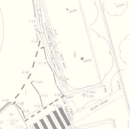
17 Server 10:/oaupubs1_AtoH*HCP8612*HCP87WB*Upper Car park*jc* N Vrow Gate Upper Car Park Section Modern soakaway Trench 0 10 m 1:300 Section 100 Figure 2: Trench plan 0 10 m
18
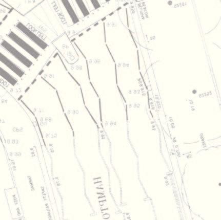
19 Server 10:/oaupubs1_AtoH*HCP8612*HCP87WB*Upper Car park*jc* N Section S?? mod Figure 3: Section 100 Sand Stone Sandstone block CBM Section 101 N 106 S?? mod m 1:25 Figure 4: Section 101
20
21
22 Head Of fice/registered Of fice/ OA S outh Janus House O sney M ead O xford O X2 0ES t : + 44 ( 0 ) f: +44 ( 0) e: info@oxfordarch.co.uk w : h t t p : / / t h e h u m a n j o u r n e y. n e t OA N orth M ill 3 M oor L ane L ancaster L A 1 1 GF t : + 44 ( 0 ) f: +44 ( 0 ) e: oanorth@thehumanjour ney.net w: n ey.net OA E a st 1 5 Tr afalgar Way B ar Hill Cambridgeshire C B SQ t : + 44 ( 0 ) f: +44 ( 0 ) e: oaeast@thehumanjour ney.net w: n ey.net Director: D avid Jennings, B A M IFA F SA O xford A rchaeology L t d is a Private L imited C o m p a n y, N o : and a Registered Charity, N o :
Archaeological Watching Brief
 Barrack Block Drainage Hampton Court Palace Archaeological Watching Brief Report May 2012 Client: Historic Royal Palces Issue No: 1 OA Job No: 5329 NGR: TQ 15485 168587 Archaeological Watching Brief Archaeological
Archaeological Watching Brief
 University Botanic Gardens High Street Oxford Archaeological Watching Brief Report January 2012 Client: Anthony Meek Issue No: 1 OA Job No: 4691 NGR: Centred on SP 5202 0607 Archaeological Watching Brief
Archaeological Evaluation and Assessment of Land at Kent Cottage, 19 Chapel Street, Hythe, Kent
 Archaeological Evaluation and Assessment of Land at Kent Cottage, 19 Chapel Street, Hythe, Kent Planning Application Y13/0463/SH Date of Report: 29/04/2015 Report for Marc Carney SWAT. ARCHAEOLOGY Swale
New Media Building, Goldsmiths College, New Cross, London Borough of Lewisham
 New Media Building, Goldsmiths College, New Cross, London Borough of Lewisham An Archaeological Evaluation for Willmott Dixon Construction by Andy Taylor Thames Valley Archaeological Services Ltd Site
Garage Site, Foots Cray High Street, Sidcup, Kent, London Borough of Bexley
 Garage Site, Foots Cray High Street, Sidcup, Kent, London Borough of Bexley An Archaeological Evaluation for Mizen Design Build by Andy Taylor Thames Valley Archaeological Services Ltd FOC 07 September
Archaeological Monitoring of Land at 29 Royal Pier Road, Gravesend, Kent
 Archaeological Monitoring of Land at 29 Royal Pier Road, Gravesend, Kent Site Code ROY/WB/15 Report for Dr Maxted Date of report 06/10/2015 SWAT ARCHAEOLOGY Swale and Thames Archaeological Survey Company
Meales Farm, Sulhamstead, West Berkshire
 Meales Farm, Sulhamstead, West Berkshire An Archaeological Watching Brief For Mr. Robert Astor by Steve Ford Thames Valley Archaeological Services Ltd Site Code CHH02/29 May 2002 Summary Site name: Meales
Land adjacent to Dingle Dock, Front Street, East Garston
 Land adjacent to Dingle Dock, Front Street, East Garston An Archaeological Watching Brief for Dr J Davies by Jo Pine Thames Valley Archaeological Services Site Code DEG99/82 January 2000 Summary Site name:
Chitty Farmhouse Extension, Wall Lane, Silchester, Hampshire
 Chitty Farmhouse Extension, Wall Lane, Silchester, Hampshire An Archaeological Watching Brief For In Touch by Andrew Mundin Thames Valley Archaeological Services Ltd Site Code CFS 08/52 May 2008 Summary
Newcombe House & Kensington Church Street
 Newcombe House & Kensington Church Street Archaeological Evaluation September 2017 Summary Site name: Newcombe House, Kensington Church Street, Notting Hill, London Grid reference: TQ 25318 80372 Site
Archaeological Investigation in advance of Development at 2 Palace Cottages, Charing Palace, Charing, Kent
 Archaeological Investigation in advance of Development at 2 Palace Cottages, Charing Palace, Charing, Kent Site Code CHAR-EV-14 NGR 95412 49439 Date of Report 18/12/2014 Swale and Thames Archaeological
Glue Pot Farm, Edwards Lane, Bramfield, Suffolk. BMF 024
 Glue Pot Farm, Edwards Lane, Bramfield, Suffolk. BMF 024 Archaeological Evaluation Report SCCAS Report No. 2013/107 Client: Keith Frost Architectural Design Services Author: Linzi Everett August 2013 SCCAS
Ivol Buildings, Woodcote Road, South Stoke, Oxfordshire
 Ivol Buildings, Woodcote Road, South Stoke, Oxfordshire An Archaeological Watching Brief For Christ Church, Oxford by Pamela Jenkins Thames Valley Archaeological Services Ltd Site Code IBSS 04/03 March
Appletree, Thames Street, Sonning Berkshire
 Appletree, Thames Street, Sonning Berkshire An Archaeological Watching Brief for Mr and Mrs A Popham by Sian Anthony Thames Valley Archaeological Services Ltd Site Code ATS 02/83 October 2002 Summary Site
New horse training area, Manor Farm, Great Kimble, Buckinghamshire
 New horse training area, Manor Farm, Great Kimble, Buckinghamshire An Archaeological Watching Brief For Redwing Structures (Marlow) Limited by Andy Taylor Thames Valley Archaeological Services Ltd Site
Land at Downsview Avenue, Storrington, West Sussex
 Land at Downsview Avenue, Storrington, West Sussex An Archaeological Evaluation for Bellwinch Homes Limited by Andy Taylor Thames Valley Archaeological Services Ltd Site Code DAS 04/21 March 2004 Summary
Old Town Hall, Market Place, Faringdon, Oxfordshire
 Old Town Hall, Market Place, Faringdon, Oxfordshire Building Recording and Archaeological Watching Brief for Great Faringdon War Memorial Trust by Jamie Preston and Steve Ford Thames Valley Archaeological
Archaeological Evaluation and Assessment of Land at Minnis Beeches, Canterbury Road, Swingfield, Dover, Kent
 Archaeological Evaluation and Assessment of Land at Minnis Beeches, Canterbury Road, Swingfield, Dover, Kent NGR: TQ 6307 1545 Site Code: MB-EV-10 (Planning Consent Y10/0311/SH) Report for Thorndene Ltd.
Windsor Berkshire. Archaeological Watching Brief. King Edward VII Car Park Extension. Archaeological Watching Brief Report
 King Edward VII Car Park Extension Windsor Berkshire Archaeological Watching Brief Report March 202 Client: Royal Borough of Windsor and Maidenhead Issue No: OA Job No: 5242 NGR: SU 972 779 Archaeological
ARCHAEOLOGICAL EVALUATION AT THE FORMER WATTON GARDEN CENTRE, NORWICH ROAD, WATTON, NORFOLK OCTOBER 2003 (Accession number WAT)
") NORTHAMPTONSHIRE ARCHAEOLOGY NORTHAMPTONSHIRE COUNTY COUNCIL NOVEMBER 2003 (Planning Application No: 3PL/1997/048/0 ARCHAEOLOGICAL EVALUATION AT THE FORMER WATTON GARDEN CENTRE, NORWICH ROAD, WATTON, NORFOLK
NORTHAMPTONSHIRE ARCHAEOLOGY NORTHAMPTONSHIRE COUNTY COUNCIL NOVEMBER 2003 (Planning Application No: 3PL/1997/048/0 ARCHAEOLOGICAL EVALUATION AT THE FORMER WATTON GARDEN CENTRE, NORWICH ROAD, WATTON, NORFOLK
ARCHAEOLOGICAL S E R V I C E S. Hurley Manor, High Street, Hurley, Berkshire. Archaeological Evaluation. by James McNicoll-Norbury
 T H A M E S V A L L E Y ARCHAEOLOGICAL S E R V I C E S Hurley Manor, High Street, Hurley, Berkshire Archaeological Evaluation by James McNicoll-Norbury Site Code: HMH14/51 (SU 8252 8378) Hurley Manor,
An Archaeological Evaluation at Granta Cottages, Newmarket Road, Great Chesterford, Essex. August 2015
 An Archaeological Evaluation at Granta Cottages, Newmarket Road, Great Chesterford, Essex August 2015 by Pip Parmenter and Ben Holloway on behalf of Mr G Elmer and Mrs L King CAT project ref.: 15/06a NGR:
Archaeological Watching Brief Report
 New Playing Fields and Athletics Track Stowe School Buckinghamshire Archaeological Watching Brief o a July 2009 client logo Client: Stowe School Issue N o : 1 OA Job N o : 4167 NGR: SP 679 380 Archaeological
Bridge House, Ham Island, Old Windsor, Berkshire
 Bridge House, Ham Island, Old Windsor, Berkshire An Archaeological Watching Brief for Mr A Chadwick by Alan Ford Thames Valley Archaeological Services Site Code BHHI98/55 August 1998 Bridge House, Ham
Northbury Farm, Castle End Road, Ruscombe, Berkshire
 Northbury Farm, Castle End Road, Ruscombe, Berkshire An Archaeological Watching Brief For Sir Colin and Lady Southgate by Danielle Milbank Thames Valley Archaeological Services Ltd Site Code NFR 07/120
ARCHAEOLOGICAL S E R V I C E S. Manor Farm, Launton, Bicester, Oxfordshire. Archaeological Watching Brief. by Aiji Castle. Site Code: LBO13/220
 T H A M E S V A L L E Y ARCHAEOLOGICAL S E R V I C E S Manor Farm, Launton, Bicester, Oxfordshire Archaeological Watching Brief by Aiji Castle Site Code: LBO13/220 (SP 6035 2285) Manor Farm, Launton, Bicester,
Evaluation/monitoring Report No. 241 KING S CASTLE NURSING HOME ARDGLASS CO. DOWN AE/12/19 SARAH GORMLEY
 Evaluation/monitoring Report No. 241 KING S CASTLE NURSING HOME ARDGLASS CO. DOWN AE/12/19 SARAH GORMLEY 1 Site Specific Information Site Name: Townland: King s Castle Ardglass SMR No. : DOW 045:024 Status:
Merrowdene, Earleydene, Sunninghill, Berkshire
 Merrowdene, Earleydene, Sunninghill, Berkshire An Archaeological Watching Brief For Mr and Mrs Jackson by Andy Taylor Thames Valley Archaeological Services Ltd Site Code MES 05/88 January 2006 Summary
Archaeological evaluation at Stables, Hatch Farm, Fen Lane, Bulphan, Essex, RM14 3RL
 Archaeological evaluation at Stables, Hatch Farm, Fen Lane, Bulphan, Essex, RM14 3RL November-December 2016 by Laura Pooley figures by Ben Holloway and Emma Holloway fieldwork by Ben Holloway and Alec
BANKHOUSE PUMPING STATION, MILLOM, CUMBRIA
 BANKHOUSE PUMPING STATION, MILLOM, CUMBRIA Archaeological Watching Brief Oxford Archaeology North May 2006 United Utilities Issue No: 2005-6/508 OA North Job No: L9397 NGR: SD 170 822 Document Title: Document
Pinnocks Wood Equestrian Centre, Burchett s Green, Maidenhead, Berkshire
 Pinnocks Wood Equestrian Centre, Burchett s Green, Maidenhead, Berkshire An Archaeological Watching Brief For Mr David Eyles by Andrew Mundin Thames Valley Archaeological Services Ltd Site Code POB 08/69
ARCHAEOLOGICAL S E R V I C E S. Becks, Park Lane, North Newington, Banbury, Oxfordshire. Archaeological Watching Brief.
 T H A M E S V A L L E Y ARCHAEOLOGICAL S E R V I C E S Becks, Park Lane, North Newington, Banbury, Oxfordshire Archaeological Watching Brief by Andy Mundin Site Code: BPN16/105 (SP 4207 3978) Becks, Park
Monitoring Report No. 166
 Monitoring Report No. 166 No. 2a Loughadian Road Poyntzpass County Down AE/08/189 Nick Beer Site Specific Information Site Address: 2a Loughadian Road, Poyntzpass. Townland: Loughadian SMR No.: DOW 033:034
Centre for Archaeological Fieldwork Evaluation/Monitoring Report No Monitoring Report No. 201
 Monitoring Report No. 201 Land adjacent to 58 Drumreagh Road Drumreagh Ballygowan Co. Down LICENCE NO.: AE/10/91E BRIAN SLOAN 1 Site Specific Information Site Name: Land adjacent to 58 Drumreagh Road,
Archaeological monitoring at Clintons, Bury Green, Little Hadham, Hertfordshire April 2008
 Archaeological monitoring at Clintons, Bury Green, Little Hadham, Hertfordshire April 2008 report prepared by Ben Holloway on behalf of Charles Britton Equestrian Construction CAT project ref.: 08/3b NGR:
ARCHAEOLOGICAL S E R V I C E S. Land north of Orchard Close, Hallow, Worcestershire. Archaeological Evaluation. by Kyle Beaverstock
 T H A M E S V A L L E Y ARCHAEOLOGICAL S E R V I C E S Land north of Orchard Close, Hallow, Worcestershire Archaeological Evaluation by Kyle Beaverstock Site Code: OCW15/224 (SO 8285 5848) Land north of
Monitoring of invasive groundworks ahead of the installation of a septic tank at 16a, 16b and 16c Donegore Hill Muckamore County Antrim
 Monitoring Report No. 177 Monitoring of invasive groundworks ahead of the installation of a septic tank at 16a, 16b and 16c Donegore Hill Muckamore County Antrim LICENCE NO.: AE/09/48 Brian Sloan 1 Site
Archaeological evaluation at Willowdene, Chelmsford Road, Felsted, Essex
 Archaeological evaluation at Willowdene, Chelmsford Road, Felsted, Essex August 2013 report prepared by Ben Holloway on behalf of Mr Anthony McGurren Planning reference: UTT/13/0235 CAT project ref.: 13/07g
Archaeological evaluation at New Hall School, The Avenue, Boreham, Chelmsford, Essex, CM3 3HS
 Archaeological evaluation at New Hall School, The Avenue, Boreham, Chelmsford, Essex, CM3 3HS December 2016 by Laura Pooley with contributions by Stephen Benfield figures by Ben Holloway and Emma Holloway
Archaeological evaluation at Redbank, Bury Water Lane, Newport, Essex, CB11 3TZ
 Archaeological evaluation at Redbank, Bury Water Lane, Newport, Essex, CB11 3TZ March 2017 by Laura Pooley figures by Ben Holloway and Emma Holloway fieldwork by Ben Holloway with Harvey Furniss and Elliott
6A St John s Road, Wallingford Oxfordshire
 6A St John s Road, Wallingford Oxfordshire An Archaeological Evaluation Stage 2 for Spearcliff Estates Ltd by Steve Ford Thames Valley Archaeological Services Ltd Site SJW03/116 January 2004 Summary Site
New Swimming Pool,West Meon House, West Meon, Hampshire
 New Swimming Pool,West Meon House, West Meon, Hampshire An Archaeological watching brief and building recording for Mr and Mrs Younger by Danielle Milbank Thames Valley Archaeological Services Ltd Site
MONITORING REPORT: No. 283
 MONITORING REPORT: No. 283 Dunluce Castle Visitor Centre Option Site D Magheracross Co. Antrim AE/14/109E Dermot Redmond List of Contents Site Specific Information 1 Account of the Monitoring 2 Discussion
Archaeological evaluation on land at Unit 1, Waltham Hall, Bambers Green Road, Takeley, Essex, CM22 6PF
 Archaeological evaluation on land at Unit 1, Waltham Hall, Bambers Green Road, Takeley, Essex, CM22 6PF by Laura Pooley figures by Ben Holloway and Emma Holloway fieldwork by Ben Holloway with Jane Roberts
Archaeological evaluation on land at Mersea Fleet Way, Chelmer Road, Braintree, Essex, CM7 3PZ
 Archaeological evaluation on land at Mersea Fleet Way, Chelmer Road, Braintree, Essex, CM7 3PZ by Laura Pooley figures by Ben Holloway and Emma Holloway fieldwork by Ben Holloway, Robin Mathieson, Nigel
MONITORING REPORT: No. 276
 MONITORING REPORT: No. 276 Between 51 and 53 Castor Bay Road Lurgan Co. Armagh AE/13/214 Dermot Redmond Site Specific Information Site Name: Between 51 and 53 Castor Bay Road, Lurgan, Co. Armagh Townland:
Monitoring Report No. 168
 Monitoring Report No. 168 Loughgall Presbyterian Church Cloven Eden Loughgall County Armagh AE/08/203 Nick Beer Site Specific Information Site Address: Loughgall Presbyterian Church, 100 Cloven Eden Road,
MONITORING REPORT: No. 289
 MONITORING REPORT: No. 289 21 Ballynarrig Road Ballydarrog Co. Derry AE/14/213E Dermot Redmond Site Specific Information Site Name: 21 Ballynarrig Road, Limavady Townland: Ballydarrog SMR No. : LDY 016:004
Interim Statement on Archaeological Evaluation on land immediately to the east of the Manor Lodge, Manor Lane, Sheffield, South Yorkshire
 Archaeological Research & Consultancy at the University of Sheffield Research School of Archaeology West Court 2 Mappin Street Sheffield S1 4DT Phone 0114 2225106 Fax 0114 2797158 Interim Statement 1107.2
Evaluation/Monitoring Report No. 243
 60m NORTH OF 64 BALLYGROOBANY ROAD BALLYNAHINCH RICHHILL COUNTY ARMAGH LICENCE NO.: AE/12/91E NAOMI CARVER 1 Site Specific Information Site Name: site 60m north of 64 Ballygroobany Road, Ballynahinch,
Archaeological trial-trenching evaluation: New Hall School, The Avenue, Boreham, Essex. July 2015
 Archaeological trial-trenching evaluation: New Hall School, The Avenue, Boreham, Essex report prepared by Ben Holloway on behalf of New Hall School Planning reference: 14/01846/FUL CAT project ref.: 15/04i
Gryme s Dyke, Stanway Green
 Gryme s Dyke, Stanway Green A short assessment of the archaeological impact of contractor s groundworks at the southern end of the Gryme s Dyke Middle earthwork February 2000 Archive report on behalf of
LYTTELTON GRAVING DOCK PUMPHOUSE (M36/327), CYRUS WILLIAMS QUAY, LYTTELTON: REPORT ON ARCHAEOLOGICAL MONITORING
, CYRUS WILLIAMS QUAY, LYTTELTON: REPORT ON ARCHAEOLOGICAL MONITORING") LYTTELTON GRAVING DOCK PUMPHOUSE (M36/327), CYRUS WILLIAMS QUAY, LYTTELTON: REPORT ON ARCHAEOLOGICAL MONITORING HNZ AUTHORITY 2016/248EQ LUKE TREMLETT AND ANNTHALINA GIBSON UNDERGROUND OVERGROUND ARCHAEOLOGY
LYTTELTON GRAVING DOCK PUMPHOUSE (M36/327), CYRUS WILLIAMS QUAY, LYTTELTON: REPORT ON ARCHAEOLOGICAL MONITORING HNZ AUTHORITY 2016/248EQ LUKE TREMLETT AND ANNTHALINA GIBSON UNDERGROUND OVERGROUND ARCHAEOLOGY
Elm Park, Station Road, Ardleigh, Essex, CO7 7RT: archaeological watching brief on installation of new water pipe
 Elm Park, Station Road, Ardleigh, Essex, CO7 7RT: archaeological watching brief on installation of new water pipe November 2015 report prepared by Howard Brooks BA FSA MCIfA on behalf of Partnerships in
Historic England Advice Report 26 August 2016
 Case Name: Kingsland Castle Case Number: 1435892 Background Historic England has been asked to review the scheduling for Kingsland Castle. The land on which the monument lies is understood to be for sale.
Epsom Water Works, East Street, Epsom, Surrey
 Epsom Water Works, East Street, Epsom, Surrey An Archaeological Desk-Based Assessment for St James Homes Ltd by Steve Ford Thames Valley Archaeological Services Site Code ESE99/85 December 1999 Epsom Water
Privy Garden Collapse
 Privy Garden Collapse Hampton Court Palace Archaeological Evaluation Report June 2010 Client: Historic Royal Palaces Issue No: 1 Archaeological Evaluation Report Client Name: Cathedral Works Organisation
Archaeological monitoring and recording at 26 Beaver Close, Colchester, Essex, CO3 9DZ
 Archaeological monitoring and recording at 26 Beaver Close, Colchester, Essex, CO3 9DZ May 2017 by Adam Tuffey and Laura Pooley figures by Sarah Carter, Chris Lister and Adam Tuffey fieldwork by Alec Wade
Archaeological evaluation: land to the rear of Clare Road, Braintree, Essex
 Archaeological evaluation: land to the rear of 41-45 Clare Road, Braintree, Essex March 2014 commissioned by Mr Mark Plummer report prepared by Ben Holloway and Howard Brooks Planning reference: 13/000585/FUL,
Archaeological Monitoring of Land to the rear of The Ridges, Valley Drive, Gravesend, Kent
 Archaeological Monitoring of Land to the rear of The Ridges, Valley Drive, Gravesend, Kent NGR: 566215 170479 Site Code RIDGE/WB/14 Report for Mr Sall Date of report 27/03/2014 SWAT ARCHAEOLOGY Swale and
EVALUATION REPORT No. 300
 EVALUATION REPORT No. 300 Southwest of 2A Cloughey Road, Portaferry, Co. Down Licence No.: AE/135/85E Sapphire Mussen Report Date: 14 th May 2015 Site Specific Information Site Name: [Southwest of 2a]
Malden Green Farm, Worcester Park, Surrey, Royal Borough of Kingston
 Malden Green Farm, Worcester Park, Surrey, Royal Borough of Kingston An Archaeological Evaluation and Desk-Based Assessment for Bewley Homes by Steve Ford Thames Valley Archaeological Services Site Code
Appraisal of proposed alterations to the boundary of Helmsley Conservation Area
 Appraisal of proposed alterations to the boundary of Helmsley Conservation Area Elmslac Road: Elmslac Road was constructed in the early 1950s in two or three stages by the Helmsley Rural District Council.
Archaeological Evaluation and Assessment of Land at the Duke of Kent site, Staple Street, Faversham, Kent September 2011
 Archaeological Evaluation and Assessment of Land at the Duke of Kent site, Staple Street, Faversham, Kent September 2011 SWAT. Archaeology Swale and Thames Archaeological Survey Company School Farm Oast,
Land South-West of Mill Co age, Gidding Road, Sawtry, Cambridgeshire Evalua on Report
 Land South-West of Mill Coage, Gidding Road, Sawtry, Cambridgeshire Evaluaon Report August 2017 Client: CgMs Consulng Issue No: 1 OA East Report No: 2080 NGR: TL 1623 8329 Oxford Archaeology Ltd i 3 August
Centre for Archaeological Fieldwork, School of Archaeology and Palaeoecology, Queen s University Belfast.
 Centre for Archaeological Fieldwork, School of Archaeology and Palaeoecology, Queen s University Belfast. Monitoring Report No. 04 Duneight Motte and Bailey, May 2004. On behalf of Monitoring Report: Duneight
Archaeological monitoring and recording at 20 St Peter's Road, West Mersea, Essex, CO5 8LJ
 Archaeological monitoring and recording at 20 St Peter's Road, West Mersea, Essex, CO5 8LJ November 2016 by Laura Pooley figures by Ben Holloway and Emma Holloway fieldwork by Ben Holloway on behalf of
T H A M E S V A L L E Y S E R V I C E S. Flood Compensation Area, Riverside Park, Wallingford, Oxfordshire. Archaeological Watching Brief
 T H A M E S V A L L E Y ARCHAEOLOGICAL S E R V I C E S Flood Compensation Area, Riverside Park, Wallingford, Oxfordshire Archaeological Watching Brief by Jacqueline Pitt Site Code: RPW10/72 (SU 6112 8934)
Examination of South Cambridgeshire Local Plan
 Matter SC6A - Policy SS/5 Waterbeach New Town Historic England( formerly English Heritage) 874 Rep Nos 59748, 60250, 60253 Examination of South Cambridgeshire Local Plan Historic England, Hearing Statement
Greater London. Greater London 6/42 (D.01.M001) TQ
 TQ") Authority 6/42 (D.01.M001) TQ 54207390 ST. JAME'S INVESTMENTS, LOWFIELD STREET AND MARKET STREET, DARTFORD Environmental Statement. Archaeology. Volume 9 of 10 AOC Archaeology Group Twickenham : AOC Archaeology
Authority 6/42 (D.01.M001) TQ 54207390 ST. JAME'S INVESTMENTS, LOWFIELD STREET AND MARKET STREET, DARTFORD Environmental Statement. Archaeology. Volume 9 of 10 AOC Archaeology Group Twickenham : AOC Archaeology
XSW11, Plumstead Portal worksites, Interim Statement for NLBH. 1 Introduction Site Methodology and fieldwork objectives...4
 Contents 1 Introduction...4 2 Site Methodology and fieldwork objectives...4 2.1 NLBH Methodology... 4 2.2 NLBH Fieldwork Objectives... 5 3 Provisional Results...6 3.1 NLBH various features... 6 3.2 Shelter
Goldings, 67 High Street, Newmarket NKT 076
 ARCHAEOLOGICAL MONITORING REPORT Goldings, 67 High Street, Newmarket NKT 076 A REPORT ON THE ARCHAEOLOGICAL MONITORING, 2004 (Planning app. no. F/2003/0899/FUL) John Craven Field Team Suffolk C.C. Archaeological
Conistone Keld/Well/Troughs Project
 CONISTONE KELD PROJECT 2018 Conistone Keld/Well/Troughs Project Location Conistone Keld is the local name for an area where a spring feeds into three troughs.(the name derives from the Viking word Kelda
Proposed Retirement Village Cole Green Way, Hertford. Archaeology Statement
 RETIREMENT LIVING MADE BETTER Proposed Retirement Village Cole Green Way, Hertford Archaeology Statement Woodlands Retirement Village RETIREMENT LIVING MADE BETTER Retirement Living Made Better Archaeology
PROPOSED DEVELOPMENT AT BRITANNIA PARK, BANGOR
 PROPOSED DEVELOPMENT AT BRITANNIA PARK, BANGOR ARCHAEOLOGICAL MITIGATION WORK Report No. 446 [08] [04] [06] [08] [06] [04] Prepared for Watkins Jones Construction March 2002 By J. Kenney Ymddiriedolaeth
Plots 1 & 2, Eves Orchard, Bures St Mary BSM 062
 Plots 1 & 2, Eves Orchard, Bures St Mary BSM 062 Archaeological Evaluation Report SCCAS Report No. 2014/014 Client: Persimmon Homes (Anglia) Ltd Author: J. A. Craven January 2014 Suffolk County Council
WRITTEN SCHEME OF INVESTIGATION
 CANAL COLLEGE 2, ROSEBANK DISTILLERY: WRITTEN SCHEME OF INVESTIGATION 1 2 Contents Background... 4 Introduction... 5 Historical Notes... 6 Methodology... 7 Staff... 9 Products... 9 Timetable... 9 Bibliography...
Public Consultation. Land at Monks Farm, North Grove. Welcome
 Welcome Welcome to our public exhibition for development on Land at Monks Farm, orth Grove. Gallagher Estates and Gleeson Strategic Land are preparing an outline planning application for new homes, open
Archaeological monitoring and recording at Priory Street Car Park, Colchester, Essex, CO1 1QA
 Archaeological monitoring and recording at Priory Street Car Park, Colchester, Essex, CO1 1QA October-November 2016 by Laura Pooley figures by Chris Lister and Emma Holloway fieldwork by Sarah Carter,
Downton Manor, Downton, near Lymington, Hampshire
 Downton Manor, Downton, near Lymington, Hampshire An Archaeological Evaluation for New Milton Sand and Gravel by Sian Anthony Thames Valley Archaeological Services Ltd Site Code DMD03/20 May 2003 Summary
Archaeological trial-trenching evaluation: land adjacent to Hillingdon House, Purdis Farm Lane, Ipswich, Suffolk
 Archaeological trial-trenching evaluation: land adjacent to Hillingdon House, Purdis Farm Lane, Ipswich, Suffolk October 2015 report prepared by Ben Holloway with contributions by Howard Brooks, Emma Holloway
25 Northgate Street, Bury St Edmunds BSE 443
 25 Northgate Street, Bury St Edmunds BSE 443 Archaeological Monitoring Report SCCAS Report No. 2014/065 Commissioned by: John Stebbings Author: Andrew Tester August 2014 Suffolk County Council Archaeological
MILLER BRIDGE, KENDAL, CUMBRIA
 MILLER BRIDGE, KENDAL, CUMBRIA Archaeological Watching Brief: Supplementary Report Oxford Archaeology North February 2010 Balfour Beatty Issue No: 2009-10/1006 OAN Job No: L10133 NGR: SD 5175 9269 Miller
Archaeological monitoring and recording at 24 St Peter's Road, West Mersea, Essex, CO5 8LJ
 Archaeological monitoring and recording at 24 St Peter's Road, West Mersea, Essex, CO5 8LJ April 2017 by Dr Elliott Hicks figures by S Carter fieldwork by Adam Wightman on behalf of Brett Lord NGR: TM
Archaeological monitoring and recording at 54 Wellesley Road, Colchester, Essex, CO3 3HF
 Archaeological monitoring and recording at 54 Wellesley Road, Colchester, Essex, CO3 3HF October 2015 by Laura Pooley on behalf of Mr Wright Planning reference: 145409 CAT project ref.: 14/12d NGR: TL
PENRHYN QUARRY BETHESDA GWYNEDD. Proposed Inert Recycling Facility DESIGN AND ACCESS STATEMENT
 PENRHYN QUARRY BETHESDA GWYNEDD Proposed Inert Recycling Facility DESIGN AND ACCESS STATEMENT September 2010 PENRHYN QUARRY, BETHESDA, GWYNEDD Proposed development of an Inert Waste Recycling Facility
Archaeological trial-trenching evaluation: Peldon Village Hall, Church Road, Peldon, Essex, CO5 7PT
 Archaeological trial-trenching evaluation: Peldon Village Hall, Church Road, Peldon, Essex, CO5 7PT December 2015 report prepared by Ben Holloway and Howard Brooks on behalf of Peldon Parish Council Planning
7.1 Area 1: Haslemere Conservation Area
 7.1 Area 1: Haslemere Conservation Area Detailed map of Haslemere Town Conservation Area as of 2006 Crown copyright and database right 2011 Ordnance Survey LA100025451 27 The Conservation Area is characterised
Yorkshire Sculpture Park Historic Landscape Management Plan. Volume I. July 2010
 Yorkshire Sculpture Park Historic Landscape Management Plan Volume I July 2010 T: 01904 691630 www.landscapeagency.co.uk enquiries@landscapeagency.co.uk Contents 3 Volume I Historic Landscape Management
Archaeological Conservation Works at Murrooghkilly Cairn, Co. Clare.
 Funding Reference No.: LIFE11/922 ITM: 516541/710578 Licence No.: 17E0498 RMP: CL002-001--- ÆGIS Reference: 89-20b Archaeological Conservation Works at Murrooghkilly Cairn, Co. Clare. Licence holder: F.
Faversham Society Archaeological Research Group. The Davington Mysteries
 1 Faversham Society Archaeological Research Group The Davington Mysteries Report for Keyhole Excavation 71B at 4, Stephens Close, Davington, Faversham, Kent Grid Reference: TR 00969 61658 2 Introduction
HERITAGE POLICY...Safeguarding the Built Heritage. Conservation Plans. A Guide to the Preparation of Conservation Plans
 HERITAGE POLICY...Safeguarding the Built Heritage Conservation Plans A Guide to the Preparation of Conservation Plans 1 2 1.0 INTRODUCTION 1.1 Scotland has a diverse built heritage: ancient monuments and
Greenbank, Fraserburgh AB43 7AB
 Greenbank, Fraserburgh AB43 7AB 10 November 2010 Greenbank, Fraserburgh, AB43 7AB SUMMARY attended the site at Greenbank, Fraserburgh, AB43 7AB on 9 November 2010. An archaeological evaluation was carried
69 DRUMLOUGH ROAD, DRUMGATH, COUNTY DOWN
 MONITORING REPORT NO. 223 69 DRUMLOUGH ROAD, DRUMGATH, COUNTY DOWN LICENCE NO. EMILY MURRAY Report Date: 13 th April 2011 Site Specific Information Site name: Townland: SMR No. : Grid ref.: County: Excavation
Conservation Area Designation, amendments and Review
 Conservation Area Designation, amendments and Review Location: Any area largely confined to Park Road and St. James Avenue which includes the following properties: St. James Church, St. James Road; No.
An archaeological evaluation on land rear of 45 High Street (the Star Inn), Ingatestone, Essex April 2009
, Ingatestone, Essex April 2009") An archaeological evaluation on land rear of 45 High Street (the Star Inn), Ingatestone, Essex April 2009 report prepared by Ben Holloway and Howard Brooks commissioned on behalf of clients by Andrew Stevenson
An archaeological evaluation on land rear of 45 High Street (the Star Inn), Ingatestone, Essex April 2009 report prepared by Ben Holloway and Howard Brooks commissioned on behalf of clients by Andrew Stevenson
National Character Area 70 Melbourne Parklands
 Summary The are a landscape of rolling farmland, parkland and woodland on the northern flanks of the ridge between Burton upon Trent and Swadlincote. The land slopes down to the River Trent, which borders
PROJECT INFORMATION. The type of development
 A LETTER OF RECOMMENDATION (WITH CONDITIONS) FOR THE EXEMPTION OF A FULL PHASE 1 ARCHAEOLOGICAL HERITAGE IMPACT ASSESSMENT FOR THE PROPOSED, CONSTRUCTION OF A FILLING STATION AND ASSOCIATED INFRASTRUCTURE
STRENSALL RAILWAY BUILDINGS CONSERVATION AREA APPRAISAL. In association with Strensall with Towthorpe Parish Council
 STRENSALL RAILWAY BUILDINGS CONSERVATION AREA APPRAISAL In association with Strensall with Towthorpe Parish Council CONTENTS Page 1 Introduction 2 2 Location and Context 3 3 Topography and Setting 4 4
Oxford Green Belt Study. Summary of Final Report Prepared by LUC October 2015
 Oxford Green Belt Study Summary of Final Report Prepared by LUC October 2015 Project Title: Oxford Green Belt Study Client: Oxfordshire County Council Version Date Version Details Prepared by Checked by