The River Runs Through It
|
|
|
- Lindsey Hood
- 5 years ago
- Views:
Transcription


1 The PRESIDENt s Commission on the River The River Runs Through It Report to the President December 15, 2006 UT


2 Table of Contents Introduction and Executive Summary 3 Charge to the Commission Commission on the River Membership Ottawa River Overview UT Master Plan Implications for the Ottawa River Task Force Team Reports: Team One Communications, Records, Outreach and Engagement Team Two River Habitat Restoration, Development and Beautification Team Three Development and Grant Funding Opportunities Overview of Planning Charette Overview of Michigan State Site Visit. Overview of UT Student Focus Groups. Overview of University/Community Forum.. Major Findings/Observations from the 1982 Ottawa River Study. Funding and Grant Opportunities Recommendations of the Commission: Projected Costs.. Conclusion Appendix Initial Conceptual Visions Planning Charette Survey Results Student Focus Groups Survey Results Community Forum Survey Results Potential Sponsors and Programs 1

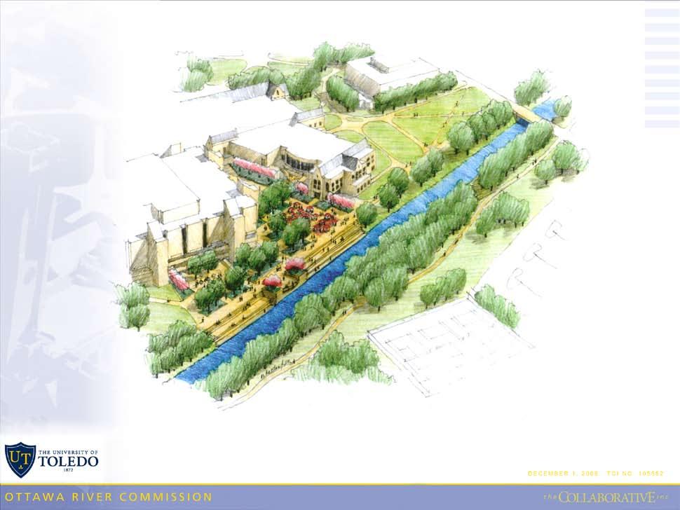
3 The River Runs Through It... Report to the President River Runs Through It Introduction and Executive Summary The University of Toledo is an institution with many great strengths that can offer a world of opportunities to a prospective student. There are a number of pockets of excellence throughout the campuses, however, there are two words that leap to the top when students, faculty, staff, political leaders, community members or any other constituent group describe The University of Toledo: Beautiful Campus. The beauty of the Main Campus is perhaps the most important and reliable recruiting tool available to UT. In fact, the national award-winning Centennial Mall is among the most scenic locations on any metropolitan campus in the country and certainly in northwest Ohio. While there is much to celebrate in terms of the aesthetics of the campus, there is significant opportunity flowing across the campus that has not been able to achieve its full potential: The Ottawa River. This report, submitted to President Lloyd Jacobs on December 15, 2006, represents a significant undertaking designed to change that fact. As President Emeritus Dan Johnson wrote in his initial charge to the Commission on the River: The Ottawa River that flows through The University of Toledo s Main Campus constitutes one of the most potentially attractive features any institution of higher education could have. A primary goal of the Commission was to engage faculty, students, staff and community members in the planning efforts and to solicit ideas and proposals from those stakeholders for maximizing the beauty, leisure-time use, scientific exploration and environmental features of the river. The membership of the Commission reflected those important stakeholder cohorts. The Commission began its work in March 2005, creating three work teams and holding monthly meetings. As part of its work effort, the Commission reached out to stakeholders through a planning charette conducted in April A local architectural firm that had conducted a previous study of the river in 1982, The Collaborative, was engaged to assist the Commission with the charette and subsequent design concepts. The primary result of the charette was the creation of three design concepts that incorporated ideas from the charette participants and from the on-going work of the Commission s three work teams. The ultimate goal was to develop a single concept design that would include important elements of each of the three initial designs and achieved the impact the Commission desired. Beginning in September 2006, the Commission began to focus its work on the single concept and continued to reach out to stakeholders by conducting a series of classroom-based student focus groups in September and a campus-community forum in October. The Commission was especially 2
4 pleased with the results of the student focus groups, with written responses from more than 400 students in nine different classroom settings. Student input exceeded our expectations and weighed heavily on the final recommendations and concept that is presented in this report. The Commission is recommending the administration move forward and create the UT Meadow/Boardwalk concept. The major elements of this plan include: Lowering the existing dike between the bridge adjacent to the Law College and the Stadium Drive Bridge (near Snyder Memorial and the Health and Human Services buildings) creating a meadows-like area extending between these bridges to the east and west and south from the river toward the Academic House; Developing a series of boardwalks that would cross through the meadows as well as strategic gathering areas located at key pedestrian crossing points; Establishing a River View Plaza on the north side of the river that would extend from the southwest corner of Carlson Library, the area between Carlson and the Student Union and to the eastern corner of the Student Union; Establishing a nature preserve incorporating a series of rain gardens (bio-swales) that trap and transform storm water runoff; Removing invasive plants and trees and selective thinning of trees to enhance view of the river; Stabilizing the banks of the river where needed; Developing riffles and other stream habitat restoration practices downstream of the bridges; Removing a small portion of the north side of Lot 10 to create open space adjacent to the river; Establishing a River Demonstration Display west of the Stadium View Drive bridge; Developing a nature walk garden adjacent to the proposed ARS building and new river paths/walkways along the river connecting to the proposed Rails to Trails bikeway, and; Developing opportunities for the Savage Hall renovation project to engage the river. The Commission on the River truly believes that the development of the UT Meadows/Boardwalk concept would parallel in importance to what the development of Centennial Mall in 1980 achieved for the main campus, especially as it relates to the overall beauty of the campus and increasing the campus attractiveness to current and prospective students. The plan is student-centered and provides for scientific exploration and environmental opportunities for our faculty and students. It will not only maximize the beauty of the river but will increase the beautification of the campus itself. The time has come to celebrate the river. 3
5 Charge to the Commission The Ottawa River that flows through The University of Toledo s campus constitutes one of the most potentially attractive features any institution of higher education could have. One of the major principles of the University s Master Planning Process is to celebrate the river. Within the framework of the master planning process, the commission formed three Task Force Teams to implement the charge. Team One Communications, Records, Outreach and Engagement Engage faculty, students, staff, community members and organizations, including those involved in river restoration projects in the commission s planning efforts; Develop opportunities and maintain media relationships (host open meetings, establish a Web site, etc.) to keep the campus community and stakeholders informed of the work of the commission, and devise opportunities for these constituencies to comment upon and provide recommendations during the development of the action plan. Working with the chair, maintain good records and preserve significant documents that will provide a reliable record of the deliberations of the commission (meeting minutes, Web site, listserv, archives, etc.). Team Two River Habitat Restoration, Development and Beautification Solicit ideas, suggestions and proposals from our stakeholders (e.g. conduct a charette) for maximizing the beauty, leisure-time use, scientific exploration and environmental features of the river. Review previous Ottawa River reports, studies and recommendations and review other river and waterfront projects across the nation, with a special focus on college campus projects, and bring forward creative ideas from these efforts for consideration, as well as confer with professional consultants as deemed appropriate. Team Three Development and Grant Funding Opportunities Sponsor individual student, faculty and class projects designed to help us achieve our objectives for the planning and development of an action plan for the river. Develop and convey to the president an action plan that integrates the river into the University s learning, discovery and engagement mission. Research and identify potential funding sources from federal, state and local grants, foundations, private contributions and other sources. Gain an understanding of the regulatory issues, maintenance and health issues that may affect the enhancement and use of the river. 4
6 Commission Leadership (Chair and Co-Chairs) The chair and co-chairs constitute the commission s steering committee. Steering Committee: Chair Dick Eastop, vice president of Enrollment Services Emeritus, UT Co-Chairs Dr. Hans Gottgens, professor, Environmental Sciences, UT Dr. Patrick Lawrence, assoc. professor, Geography, UT Dr. Steven LeBlanc, chair, University Beautification Committee; Associate Dean for Academic Affairs, Engineering, UT Tobin Klinger, director, University Communications, UT Task Force Team Leaders: Tobin Klinger Communications, Records, Outreach and Engagement Hans Gottgens River Habitat Restoration, Development and Beautification Patrick Lawrence Development and Grant Funding Opportunities Committee Membership: Michael Cassidy, president, Cassidy Consulting Kristin Cavanagh, undergraduate student, UT Todd Crail, graduate student, UT Kurt Erichsen, president of Environmental Planning, TMACOG Rick Francis, director, Research Information Systems, UT Dennis Garvin, director, City of Toledo Parks, Recreation and Forestry Dr. Dan Johnson, president emeritus, UT Brenda Leady, coordinator, Biological Sciences, UT Chuck Lehnert, AVP, Facilities and Construction, UT Joel Lipman, professor, Art and English, UT Steve Martin, associate professor, Pharmacy, UT Richard Meyers, landscape architect, The Collaborative (Retired) Linda Smith, University Honors Program, UT Jim Spengler, executive director, Toledo Area MetroParks Carol Stepien, professor and director, Lake Erie Research Center, UT Marcia Suter, assistant. dean, University Libraries, UT Marc Thompson, village manager, Ottawa Hills Nick Wittenberg, undergraduate student, UT Harry Wyatt, former associate VP, Facilities Management, UT 5
7 Ottawa River Overview The Ottawa River is 45 miles long with a watershed (drainage basin) of square miles; of which are in Ohio. Its average gradient is 4 feet per mile. The watershed begins in northeastern Fulton County where the river is known as Ten Mile Creek. It flows east through Lucas County, crossing through a portion of the Oak Openings region where it is joined by North Ten Mile Creek from Lenawee and Monroe counties in Michigan. The river continues to flow through Lucas County until it joins Maumee Bay and Lake Erie in Monroe County. The soils of the watershed can be roughly divided into two basic classifications: 1) areas dominated by level to gently sloping loamy and clayey soils on lake plains; and 2) areas dominated by level to gently sloping, sandy soils on lake beaches, the Oak Openings. The Ottawa River watershed can be divided into three major reaches, or parts, based on the dominant stream regime within each reach. The upstream Ten Mile Creek reach from the headwaters, or source, to the city of Sylvania, has a stable channel. The banks are low (15 to 25 feet) with indistinct valleys and floodplains. The headwaters of the North Branch of Ten Mile Creek are the Ottawa Lake Drain originating in Riga Township, Lenawee County, Michigan. The confluence is in Whiteford Township, Monroe County, Michigan. This area is very flat with indistinct floodplains. Both headwater areas are primarily in agricultural land use. In addition to agriculture, there is continued residential development within the city of Sylvania, western Sylvania Township, and the villages of Metamora and Berkey. The gradient here is a gradual 4.3 feet drop per mile. The major tributary to Ten Mile Creek is Prairie Ditch, which flows through Secor Metropark. The river meanders through the village of Ottawa Hills and crosses several damn structures, including the Secor Road dam located just west of Secor Road and the UT Main Campus. There is a current proposal by Ohio EPA, ODOT, the village of Ottawa Hills, and TMACOG to remove the Secor Road dam and undertaken some stream restoration at the site. The Ottawa River on the UT Main Campus is located within the middle reach, the area between river miles 20 and 5. The banks are high (35 to 45 feet or more), unstable and are intermixed with distinct floodplains. The Ottawa River flows through the Wildwood Preserve Metropark north of the Village of Ottawa Hills. Other recreational areas along the Ottawa River within this reach include Camp Miakonda Boy Scout Reservation (where a dam was removed in 2003) and Ottawa Park. The major problems are urbanization with the filling in of the floodplains, urban runoff, and destruction of wetland areas. On the UT campus, the Ottawa River is approximately 4,000 feet long, the channel ranges in depth from 14 to 16 feet, and it is 60 to 70 feet wide at the channel base during low flow conditions. In 1960, the central section of the river through campus was straightened, widened, deepened, and levees of 4 to 6 feet height were added to the banks. These stream modifications were intended to address flooding concerns by increasing the capacity of the river channel to hold excess discharge from upstream during peak flow conditions. Recent research on the aquatic ecosystem of the river on campus has revealed a healthy and diverse fish population numbering more then 20 species, 6
8 including Northern Pike, Yellow Perch, and Largemouth Bass. Several freshwater mussel species have also been identified. The water quality of this middle reach of the Ottawa River (which includes the UT Main Campus) is marginally good, but it declines to fair downstream from to Secor Road at the entrance to the University of Toledo. Hill Ditch and Heldman Ditch are tributary to the Ottawa River just west of Secor Road. Further downstream from The University of Toledo to Stickney Avenue the middle reach water quality is poor. Critical water quality concerns associated with the Ottawa River on the UT Main Campus are turbidity, nitrates, and fecal coliforms In 1991, the Toledo Health Department and Environmental Services Division, in response to health advisories issued by the Ohio Department of Health with support of Ohio EPA, posted warning signs along the Ottawa River within the city of Toledo limits, including the UT campus. The signs state that Due to water pollution, this area of the river is unsafe for swimming, skiing, other water activities and fishing. Fish caught in this area may be contaminated and unsafe to eat. The health advisories and subsequent sign postings were the result of analysis of fish tissue samples conducted along the Ottawa River which revealed high concentrations of PCBs. During the work of this Commission, several management issues in regards to the Ottawa River on campus were identified by review of key documents, consultations and in discussions by the Commission. These include: flood control, channel modification, stormwater runoff, unstable banks, alteration of native riparian vegetation, water quality, changes to the floodplain, and the loss of natural aquatic habitat and function. 7
9 UT Master Plan Implications for the Ottawa River The University of Toledo undertook a long-range facility master plan in spring At the outset, the University recognized the strong but underutilized presence of the Ottawa River running through the middle of the Main Campus. Prior to starting the master planning process, a set of master planning principles was developed and approved by the Board of Trustees in April Among those principles was the following: PRINCIPLE #9: Integrate the Ottawa River into the Bancroft campus in a celebratory and environmentally sensitive way. This might involve: Strengthening the non-motorized circulation system along the river (river-walk, bike trail, etc.); Creating outdoor gathering spaces (such as a plaza or amphitheater) or informal recreation areas that take advantage of the river; Locating and designing buildings to take advantage of proximity to and views of the river; Using the Ottawa River for educational and research activities; and Coordinating efforts to improve the Ottawa River with surrounding communities and governmental agencies. Throughout the master plan process, the Ottawa River was a pivotal element in discussion and evaluation of master plan alternatives. The master plan was developed and ultimately approved by the Board of Trustees in April There are several outstanding elements of the plan that embrace the river and offer opportunity for further exploration and development by the President s Commission on the River: A riverfront plaza development between Carlson Library and the Student Union and reaching south to the Ottawa River, which might be synergistic with an interior Information Commons project on the first floor of Carlson Library; Development of a science zone of campus, with a new science research building and a new building for the Agricultural Research Service (ARS) of the U.S. Department of Agriculture, which along with existing Wolfe Hall will create a new outdoor mall area that would extend south toward the Ottawa River. A new pedestrian bridge across the Ottawa River connects this science zone with the residential zone on the south side of the river. The ARS Building specifically calls for development of exhibition gardens and views toward the Ottawa River; Renovation and expansion of Savage Hall, both to the south and to the north toward the Ottawa River, which will be synergistic with bridge refurbishment and pedestrian accommodation to the North Parking Garage; and Recovering green space to the south of the Ottawa River through the elimination of Parking Lot 5 and elimination of a small portion of Parking Lot 10. These specific elements of the University s master plan offered the President s Commission on the River a good basis to start its work. The elements are conceptual in nature and vary with regard to priority for funding. 8


10 Team One Communications, Records, Outreach and Engagement A key component of the work of the President s Commission on the River involved communicating the group s work, as well as putting into context for the campus community. It was important to build excitement for the initiative and to develop an understanding of the scope of the effort and potential outcomes. Ultimately, the message was simple: By working to rejuvenate the Ottawa River, the University can develop a focal point of interest that complements campus beauty and provides research and recreational opportunities for students, faculty and staff. The institution s traditional communications vehicles were used to highlight the effort at its inception with stories in UT News and on the UT Web site and during the commission s work. Additionally, the internal organs promoted the public forums that were held to garner community input and feedback on the river. An article on the final report also is under consideration. Through the Office of University Communications, advertisements were placed in the Independent Collegian, further promoting the commission and forums to the important student audience. During the work of the commission, information was collected on the history of the river and important related documents have been archived. 9

 to assemble information and to communicate with other members of the commission.")
11 Team Two River Habitat Restoration, Development and Beautification Team Two members included Mike Cassidy, Brenda Leady, Steve Martin, Jim Spengler, Harry Wyatt and Hans Gottgens (chair). The team was charged with generating ideas for enhancing the beauty, leisure-time use, scientific exploration and environmental features of the river. The overall goal was to bring forward creative proposals using previous studies, recommendations from experts, and concepts from other river and waterfront projects, with a special focus on college campuses. Team Two used an electronic bulletin board ( to assemble information and to communicate with other members of the commission. The bulletin board was structured to support Team Two s charge with five sub-categories. Sixteen articles were posted in five categories by seven registered users. 1.Collect detailed electronic maps of the Ottawa River (past and present). Electronic maps of the Ottawa River on campus were assembled and used for public presentations, the charrette and final concept maps. 2. Compile water quality and biological records for the Ottawa River on campus. Water quality data were obtained from the City of Toledo, Division of Environmental Services. Data consisted of monthly measurements on campus since 1990 for (among others) nutrients, dissolved oxygen, fecal coliform bacteria, and dissolved and suspended solids. As is typical for rivers that flow through agricultural and urban/suburban regions, levels of nutrients, coliforms, and solids were high and highly variable within and among years. Oxygen levels were generally sufficient to support heterotrophic aquatic life (such as fish and mussels). In addition, the water discharge record was obtained (U.S.G.S. station # ) with data from and 1977-present. Fish are abundant in the river. Student projects uncovered the presence of a total of 26 species of fish in the campus stretch of the river. The community includes species of recreational and commercial interest (such yellow perch, northern pike and various sunfish species). In addition, 12 species of native unionid mussels and one exotic clam species have been discovered in the Ottawa on campus. 3. Inventory consultants/agency representatives that may assist in the development of proposals for the Ottawa River. Two consultants were contacted to assist with the charette and the development of the final concept plans. 4. Inventory river projects on other college campuses. Images were assembled of river projects on the campuses of the University of Florida and the University of Wisconsin. Michigan State University was selected for an on-campus visit (March 14, 2006) by Commission members. 5. Review the 1982 Master Plan for the Ottawa River on the UT campus. Major findings from the 1982 study are presented elsewhere in this report. 10
12 Team Three Development and Grant Funding Opportunities This team held numerous consultations and meetings with University faculty, staff, administrators and students. It also had contacted several local and regional agencies and organizations, including the village of Ottawa Hills, city of Toledo, TMACOG, Ohio EPA, Lucas County and the Army Corps of Engineers. The following recommendations were made: The Office of Research develop and maintain an online database of potential research funding programs related to river restoration and related projects; The UT Foundation and Office of Research consider the establishment of an annual competitive grant program to fund faculty and undergraduate research and projects related to the Ottawa River; The University undertake a Stormwater Management Plan for Main Campus in order to examine and address issues associated with stormwater runoff, retention and discharge into the Ottawa River; The University establish an annual Celebrate the River event to encourage community and student engagement efforts associated with the river, including stream bank cleanup, service learning activities, student learning, and public awareness; The Office of Research form an UT Ottawa River Research Forum, which would consist of faculty, staff and students with research interests in various aspects of the river and that this forum would meet regularly to review research efforts and provide direction to such activities on campus; The Center for Teaching and Learning promote opportunities for classroom instruction and teaching related to the Ottawa River; The University, including expertise from the Health Science Campus, examine issues associated with water quality and related human health aspects of the river with particular focus on the aquatic ecosystem conditions as related to bacteria, contaminated sediments and levels of pollutants within fish; and The University continue to support and participate in regional collaborative efforts to address environmental and associated planning issues within the Ottawa River watershed with special interest on efforts in areas adjacent to Main Campus, including the village of Ottawa Hills and city of Toledo properties. 11
13 Overview of the Planning Charette On Friday, April 7, 2006, the commission hosted a planning charette in the UT Student Union. The aim of the meeting was to introduce the University community to the work of the commission and provide some initial general ideas and concepts that could be considered for the Ottawa River on Main Campus. Approximately 60 individuals attended the meeting to hear presentations, view display materials and provide their comments and input. Professor Hans Gottgens from the Department of Environmental Sciences gave an overview presentation on the Ottawa River, focusing on environmental issues and recent research on aspects of aquatic ecology. Steve Phillips of Oxbow River & Stream Restoration Inc. provided examples of urban stream improvements that have been completed at other sites. Display boards were placed around the room highlighting the UT Facility Master Plan, historical images of the main campus, research on fish population studies and sample stream restoration projects. A survey was distributed to all meeting attendees and key results are listed below. 1). What would you identify as the most critical issues in regard to the Ottawa River on campus? address appearance and aesthetics; meet water quality standards; improve biological diversity; lack of awareness or understanding; and restoring natural habitat. The river needs to become a part of the University landscape rather than separate from it. 2) What ideas or recommendations do you think should be in the final report of the Ottawa River Commission? connect river/floodplain to adjacent campus area; create riffles to filter and clean the water; re-establish and stabilize the floodplain and habitat diversity; creating recreational options (trails, gathering areas); bank stabilization/improve the appearance of the banks; and be aware and in control of the impacts of storm water runoff. Efforts should be made to restore the natural aquatic ecosystem in the river. 3) How should the River Commission involve and engage members of the UT community in our efforts? appeal to the alumni and get them involved; continue program like today s informational session; reach out to other communities within the University such as fraternities, sororities, board members, employee unions and others who may have different concerns than the commission for their input; tailor class assignments/projects across many departments to include Ottawa River restoration plan; and engage students. Involve student organizations and classes on campus to work on river improvements. 12
14 4) The University s goal is to integrate the Ottawa River into the Bancroft Campus in a celebratory and environmentally-sensitive way. If the University was in position to do ONLY ONE THING to achieve that goal, what ONE action, task, improvement or project should be pursued? floodplain improvements, remove levees; naturalize channel; restoring streambank and increasing vegetation while making it more interactive with the UT community (more seating around the river); remove hard surface parking near the water; and make the river an educational opportunity for everyone in the community. Improve the appearance of the river bank, remove garbage. 5) Any additional comments and/or suggestions? make the river a priority in the capital campaign; encourage rain gardens, porous pavement where possible; make the river a positive instead of an unnoticed piece of our campus; it is important to take a long-term view of this project; allow the river to grow wild around the banks plant many species of native trees; and restore biodiversity and reduce silt and chemical inputs. Allow the river to grow wild around the bank; plant many species of trees. 13
15 Overview of Site Visit to Michigan State University Eleven members of the commission took advantage of an invitation from Michigan State University (MSU) to visit their campus. The goal was to become familiar with their approach to enhance the aesthetics of the Red Cedar River on campus and to improve its potential for research, education and public outreach. During its March 14, 2006 visit, Commission members made the following observations: 1. The MSU campus is required to comply with Phase II regulations of the Clean Water Act to control pollutants in storm water discharges to the maximum extent practicable. As a result, MSU is working to meet its permit requirements by implementing research and education initiatives across campus. This work is coordinated through a special office (MSU Institute of Water Research/ MSU Extension) with a designated staff position and an operating budget. 2. MSU is collaborating with other communities in the greater Lansing area to develop a watershedbased plan for the control of storm water in the Red Cedar/Grand River watershed. 3. The greater campus community is educated on the Red Cedar River by the use of signs, posters, Web-based information, decorated garbage cans, etc. For example, display tables are setup before sporting events when large numbers of people visit campus. 4. Efforts have been underway to maximize access to the river (outlook points, benches, selective clearing and walkways). There was talk of a fishing ordinance and allowing sport fishing on campus. There even seems to be a limited-use water trail with a canoe livery. 5. The need for the Red Cedar River to migrate laterally into its floodplain is recognized and, where possible, realized. There is a dam on the campus stretch of the river. It was not clear if the university plans to decommission this dam. 6. MSU has made a research fund available for faculty to initiate projects on the river. 7. Within the MSU capital campaign, a Campus Beautification Fund has been designated. These funds are used for programs that enhance the Red Cedar River. MSU also has a commemorative tree and bench program. 8. Grounds/maintenance a. Fertilizer applications (particularly close to the river) are reduced or eliminated. b. Mowing is minimized in certain areas; straight mowing lines are avoided and winding paths ( meandering lawns ) are encouraged. c. Mulching and composting are encouraged. d. Rain gardens and porous pavement in parking lots are encouraged and applied. e. An aesthetically-pleasing area has been developed where the MSU botanical gardens connect with the floodplain of the river. 14


16 Overview of the Student Focus Groups During the week of September 11, 2006, a presentation on the ongoing work of the commission was made to nine student undergraduate and graduate classes on the Main Campus. The selected classes that were selected had some degree of environmental content. The courses included: GEPL 3900 Environmental Planning GEPL 1100 Environmental Geography EEES 2010 Introduction to Environmental Studies EEES 3050 General Ecology EEES 2150 Biodiversity CIVE 3610 Water Supply PSC 4340 Environmental Policy ENGL 2010 English Composition GEPL 6920 Research Design For each class presentation, an overview of the main issues and concerns regarding the Ottawa River on Main Campus was provided by members of the commission, with three initial planning concepts revealed: River Paths, The Meadows and The Boardwalk. A survey was then administered to all students, resulting in a total of 403 responses. A summary of the key results, including the top five responses to each question, is provided below with the number of responses indicated. What would you identify as the most critical issues in regards to the Ottawa River on campus? Water Quality 256 Garbage 57 Aesthetics 47 Natural Habitats 36 Beautification 42 The issues associated with stormwater discharge and surface runoff into the river on campus were identified as concerns, in addition to overall appearance of the river and banks. What ideas or recommendations do you think should be in the Final Report of the Ottawa River Commission? Improve Water Quality 62 Education 47 Protect Natural Habitats 37 Provide access/viewpoints 76 Beautification 56 The ability to access and enjoy the river was noted by many respondents, and concerns over the presence of debris and garbage was raised. 15
17 The University s goal is to integrate the Ottawa River into the Main Campus in a celebratory and environmentally-sensitive way. If the University was in position to do ONLY ONE THING to achieve that goal, what ONE action, task, improvement or project should be pursued? Provide Access/View points 35 Create Trails/Paths 52 Education/Awareness 39 Improve Water Quality 38 Beautification 43 Allowing better access to the river with overlooks, view points, paths and trails was identified by many students, as was the need to provide better public awareness of the river and information on the environmental conditions. Make a plaza and river walk so we would be able to see the river and enjoy it. 5) Of the three (3) proposed Ottawa River Planning Concepts, which would be your first choice? River Paths 86 The Meadows 87 Boardwalk 186 The students preferred the Boardwalk concept, which provides for a mix of stream restoration, access and trails, while still maintaining the aesthetics and natural landscapes of campus. 16
18 University/Community Forum The President s Commission on the River conducted a public forum in the Student Union on October 6, The goal of the forum was to receive input regarding the three conceptual visions the commission was developing. The three concepts were displayed on boards and in a PowerPoint presentation, and those in attendance were asked to complete a survey. The forum was widely promoted (UT News article, two ads in the Collegian and a campus-wide from President Jacobs). Those in attendance provided interesting and valuable input to the commission. As noted in the section of this report that describes the extremely successful student focus groups (over 400 survey responses were completed), the commission believes that we have been able to solicit a more than satisfactory amount of input from students. This was important to our work since being student centered was always a focus of the commission s work. Water quality and restoring the river back to its natural qualities seemed to head the list of what those in attendance would like to see. There were additional points of interest that are outlined below: Regarding preferred concept and elements: The Meadows and Boardwalk plans, with terraced plaza, gathering areas and overlooks (on the south side as well as north side) were the preferred concepts of those in attendance. The River Path sidewalk scheme also received support. One comment seemed to capture what most were saying: I prefer the Boardwalk like the river opening up as more natural and have boardwalks as they have at Wildwood. Regarding immediate impact opportunities: Major themes were connecting the Student Union and Carlson Library with the river and clearing vegetation and replacing those with native species. Regarding what can be done in next five years: Establishing the meadows by lowering the dike, removing soil and installing native plants and rain gardens were a general themes of this discussion. The establishment of a courtyard/plaza between Carlson Library, the Student Union, Snyder Memorial Hall and the river also received strong interest and support. One participant urged the commission to establish a water-monitoring program and create an actual class to continue the data collection. Regarding long term planning: The discussion centered on orienting any new buildings in harmony with the river (which is currently not the case for existing buildings). One participant urged the University to construct buildings with overlooking balconies in order to engage the river. Removing Parking Lot 10 and the tennis courts also were of interest. 17
19 Regarding opportunities to integrate the river into the campus in a celebratory and environmentally sensitive way: Planting vegetation that is natural to the river and removing invasive plants and adding riffles and enhanced views of the river received support. The plaza concept and restoring the natural flood plain by lowering the dike was again mentioned. When we asked if there were any concepts that the commission should NOT recommend, one participant seem to capture the mood of the group and certainly that of the commission.... to do nothing would be the biggest mistake. 18
20 Major Findings / Observations from 1982 Ottawa River Study The 1982 Ottawa River Study, completed by the Toledo architectural firm The Collaborative, was originally conceived as a General Concept Plan for future development and beautification of the Ottawa River through The University of Toledo campus. The study was completed under the direction of the Campus Beautification Committee and its chair at that time, Dr. James Brunner. The report stressed that flooding periodically threatens to damage existing University buildings and facilities, and future development must attempt not only to prevent additional flooding, but also to minimize existing problems associated with those times of high water. The report specifically noted the following: This aspect becomes a significant challenge, as the hydrology of the Ottawa River watershed is in constant transition. Upstream development and urbanization are continually increasing the downstream flooding potential. No attempt to control and contain dynamic natural systems can be entirely successful. Therefore the project should include a long-range management plan. The management plan should incorporate: a) Routine inspections of the river banks and levees; b) Maintenance of the inner and outer channel to insure that the channel roughness does not significantly increase with time, c) Periodic improvement of outfall structures to prevent erosion around these structures, and d) Periodic levee maintenance to insure that leakage of water through the levees does not occur during high water flows. The report s concluding statement set the tone for the 2006 President s Commission on the River: In conclusion, we feel the recommendations embodied in this report will, when fully implemented, result in many found and newly used areas within the campus, which are truly diamonds in the rough just waiting to be discovered. We believe the Ottawa River can truly have a front door atmosphere, which will become a major focal point and unifying element not found at many universities in this country. At the same time, these improvements are designed to recognize and suggest solutions for the serious problems of erosion and deterioration of existing banks and levees, as well as the problems of widely fluctuating water levels and flooding which threaten several campus structures and other valuable facilities which lie within the floodplain. In addition to the observations noted above, the 1982 report contained a number of additional, specific recommendations. Three of those recommendations are embodied in the 2006 commission s report: 1. Create a Campus Core / River-Oriented Focal Point directly south of the Student Union, Snyder Memorial Hall and Carlson Library. 2. Develop pedestrian walks allowing people to freely circulate on both sides of the river, from the existing pedestrian bridge at Savage Hall to the bridge at the Law Center. 3. Develop landscaping all along the river channel, with the area from the Douglas Road Bridge to the existing pedestrian bridge south of Carlson Library to be treated in a more formal way. The area west of the Carlson Library pedestrian bridge should be landscaped and maintained in a more natural, less formal way, especially on the south side of the river and west of the Law Center bridge. 19

21 Funding and Grant Opportunities In recent years, The University of Toledo has created one of most attractive metropolitan campuses in the United States and consistently, prospective students, as well as returning alumni, comment on its beautiful appearance. Great strides have been made to create a setting that is at once sequestered, vibrant and collegiate. The Ottawa River Meadows/Boardwalk Plan by transforming an urban stream into an environmental asset and aesthetic attraction will further enrich the quality of campus life both environmentally and aesthetically. The Commission is excited about the possibilities this project creates. In addition to advanced opportunities for student learning, community engagement and sponsored research, improvements to the Ottawa River will capture the imagination of a wide variety of funders. Included from the private sector are alumni, friends, corporations and foundations. While not formally a priority of the current capital campaign, the river project can strengthen the campaign by providing additional sources of attractive engagement, funding and naming opportunities for donors to consider. Overlooks, rain gardens, seating areas, educational kiosks, walkways, and educational outreach programs are just a few areas donors may be interested in supporting. Within the public sector opportunities exist for competitive state and federal grants as well as congressionally directed funding. Our review of likely sources clearly indicates that a number of the sub-projects are strong candidates for particular programs or approaches. Funding possibilities for the overall project are strengthened by these factors: The project s appeal to the many potential donors (alumni, friends, corporations, and foundations) with interest in campus beautification, environmental issues, wildlife restoration, flood control, student recruitment, and exemplary stewardship; Timeliness as local and regional pilot project for storm runoff and urban stream management; opportunities for partnership with community organizations; and Research possibilities for faculty and students, leveraging existing faculty expertise; and high potential for competitive and Congressionally-directed funding based on the items above. Projects with Strong Funding Appeal Improved access via river overlooks, gathering places and trails Beautification with native plantings along and above the banks Raise awareness and education, including interpretive signage Demonstration project for stream restoration Creation of an urban aquatic, terrestrial and avian wildlife preserve Establishment of a real-time online river monitoring station Promotion of faculty and student research projects in the natural sciences, landscape architecture and resource management 20
22 Foundations and Corporations A cursory search was conducted in the FoundationCenter s online database using a variety of search terms related to the environment and education and geographical restrictions, and at least 15 corporations or foundations appear to be strong potential matches. Note that once the funding projects/programs are prioritized and frameworks and budgets are developed, more in-depth searches can be conducted to determine the best possible prospect pool. Existing University Capital Projects The University is well-poised to incorporate particular Ottawa River sub-projects in the landscaping and water management plans of the ARS building, as well as in the renovation of Savage Hall. Examples include terraces, walkways, and raingardens to manage roofwater runoff. In both cases, the allocation of funds in a manner consistent with the recommendations of this report, as well as the master plan, would presents an opportunity for efficient leveraging of capital project funds, as well as means of integrating both into a consistent, progressive, and inviting vision of the river and adjacent buildings. Congressionally-Directed Funding UT has an excellent track record in securing congressionally-directed funding, particularly in areas of environmental research and impact. Funding for a core portion of the Ottawa River Project (e.g. turning the Flats area into sloped area with boardwalks and areas for native grasses), in the range of $500,000 to $1.5 million, could be sought through congressionally-directed funding. Competitive State and Federal Grant Programs With the faculty expertise in its departments of Environmental Sciences, Geography and Planning, Civil Engineering, the Lake Erie Research Center and elsewhere, The University of Toledo is wellpositioned to compete for a number of small and large grants (see the list of potential sponsors and programs in Appendix). While it is somewhat unlikely that grant monies will fund 100 percent of a sub-project, by leveraging University cash and in-kind contributions through matches on proposals, grants greatly extend University funds while advancing the core missions of research and education. In addition, the potential for involvement of undergraduates in watershed-related research, both through summer projects and as part of the Environmental Sciences curriculum, can hardly be overstated. The example of the NSF-funded Research Experience for Undergraduates (REU) programs at the university is illustrative. Conclusion The UT Meadows/Boardwalk Plan offers a wide range of funding opportunities. It is important to note that a commitment by the University will accomplish much more than an ambitious and lasting enhancement of the campus experience and institutional stewardship of natural resources, though those are certainly adequate justifications in themselves. In addition, it will create opportunities for an integration of sustained environmentally-centered faculty and student research on campus in timely focus areas. Moreover, it will create lasting opportunities for UT to connect more strongly with its natural stakeholders including educators, researchers, neighbors, community organizations, businesses, foundations, alumni and government agencies. 21


23 Recommendations UT Meadows/Boardwalk Introduction One of the major guiding principles that has been a focal point for the commission is the need to celebrate our river not hide it. In addition, several other guiding principles influenced our work, including student centeredness, campus beautification and enhancing faculty and student opportunities for research and education. The recommendations outlined below are divided into three separate zones and are illustrated on pages 26, 27 and 28. Zone One Zone One encompasses the portion of the Ottawa River that extends from Secor Road to the Campus View Drive bridge. The commission envisions most of Zone One to remain in a natural state and to provide various educational demonstration opportunities and beautification enhancements. Zone One Recommendations: North side of the river 1. Establish the Secor Environmental Reserve and create four rain garden sites to collect and treat storm water drainage/run-off. Native grasses and plantings that are tolerant to water would be utilized in the rain gardens. These plantings would provide filtration that would assist in a purifying function and would add to the beautification of the area. The establishment of these rain gardens may eliminate a limited number of parking spaces in the Law Center parking lot. 2. Remove invasive species and conduct a selective thinning of trees and plants in this zone, but maintain the vast majority of the existing trees in order to provide bank stabilization and screening. The south side of the river does not provide desirable views due to the existing parking lots and the back of an apartment complex. 3. Remove the chain link fence that is currently on the east side of the Law Center parking lot; however, maintain the plantings. This area is a potential site for one of the rain gardens. South side of the river 4.Stabilize the south side bank. This is the major issue for the south side of this zone. Presently, a concrete walkway, several light posts and the north fringe of the Health Center parking lot are jeopardized by potential subsidence of the river bank. The Commission recommends that the University seek counsel and recommendations from a consulting firm that specializes in bank stabilization. Zone Two Zone Two encompasses the portion of the Ottawa River that extends from the Campus View Drive bridge to the Stadium View bridge. The commission envisions Zone Two to be a high visual impact area and would experience the most dramatic change. 22
24 Zone Two Recommendations North side of the river 1. Establish a River View Plaza that will encompass the space directly south of Carlson Library, the area east of Carlson Library to the west side of the Student Union and extending to the southwestern edge of the Student Union. Provide comfortable seating and landscaping features that will create an inviting setting to encourage the University community to use this space as a major gathering area similar to what Centennial Mall has accomplished. The River View Plaza concept is compatible with the latest version of the UT Master Plan. 2. Renovate/enhance the existing Carlson Library patio area that is currently present on the east side of Carlson Library in order to become a complementary feature to the new River View Plaza. This new space would also be a natural extension of the new Information Commons that is envisioned for the ground floor of Carlson Library. 3. Create a Nature Walk Gardens that would extend from the western edge of the River View Plaza past the future Agriculture Research Service (ARS) building and connecting to the east side of West Campus Drive. Another rain garden would be established in this area and the Nature Walk would complement and take advantage of the potential demonstration gardens that will be a feature of the new ARS building. 4. Remove invasive plants and trees from the West Campus View Drive extending to the Stadium Drive bridge to create/improve views of the river, especially for those using the River View Plaza. Establish a River Walkway that would connect the River View Plaza to the east with the walkway that is envisioned for Zone Three. South side of the river 1. Lower the existing dike from the Campus View Drive bridge to the Library bridge. The removal of the dike would allow the area directly south of the river and extending to the Academic House to be re-established as a flood plain and would allow for the creation of a meadow-like area that would incorporate a variety of native plantings interspersed with mowed lawn areas that would add color and would contribute to the meadows concept. Lowering of the dike would require a careful regrading of that area in order to maintain the several mature trees and would allow the water during flood events to naturally recede back to the river. 2. Remove invasive plants and conduct a selective thinning of trees that would create opportunities to enhance river views and provide opportunities to engage the river. 3. Establish a series of boardwalks and pathways with educational signage that would wind through the meadows, providing views of the meadows and allowing for maintained pedestrian traffic during the several times during the year that this area would become a flood plain. The commission recommends boardwalks that would be 20 feet wide allowing for pedestrian traffic and easy snow removal. 4. Establish five large (50 feet wide) patio decks/areas with comfortable bench seating that would be located strategically at boardwalk/pathways intersections to encourage opportunities to gather and enjoy the meadows environment. 5. Establish a football tailgating area that would be located in a wedge-like area on the southwest edge of the meadow (next to and west of the tennis courts). 6. Establish a link to the forested wetlands that would connect the UT Meadows / Boardwalk to the existing wetlands that lie on the west side of Parks Tower. 23
25 7. Expand a green belt between the Library and Stadium View bridges. This would allow for a new River Walk on the south side of the river and would require the removal of approximately 50 spaces in Parking Lot 10. Establish a patio / gathering area west of the Stadium View Drive. 8. Provide new plantings of native trees (maples, sassafras, hickories, oaks, etc.) and other plant species that would enhance the southern views from the River View Plaza across the river. 9. Add a series of four riffles (using boulders / rocks) on the west side (downriver) of the existing bridges that would oxygenate river water, and create rippling sounds for the enjoyment of those utilizing the Nature Walk and River View Plaza. Riffles also provide habitat for invertebrates, amphibians, fish and wading birds. 10. Establish a River Demonstration Display that would be incorporated in the patio / gathering area west of the Stadium View Drive. This area would allow UT faculty and students to help educate the University community and campus visitors on the ecological value of the river. For example, it is generally not known that the river is home to 26 species of fish (including northern pike, bass and steelhead trout) and a dozen species of native mussels. Zone Three Recommendations Zone Three encompasses the portion of the river that extends between the Stadium View Bridge and Bancroft Street. This zone will be impacted by the future Savage Hall extension / renovation project. Because details of that expansion are still in a preliminary stage, the commission is not in a position to offer detailed recommendations until those plans are developed. The commission believes that the section of the river that extends from the Savage Hall Bridge to Bancroft Street (south of the parking garage) should not be developed and should remain in its current state. North side of the river 1. Extend the River Trail from the Stadium View bridge to the Savage Hall bridge to allow for pedestrian traffic and enjoyment of the river. 2. Conduct selective thinning of trees and invasive plant material to create/improve views of the river in this zone. South side of the river 1. The Savage Hall expansion project should engage the river. The future Savage Hall project needs to take advantage of its proximity to the river and engage the river by creating river views and gathering opportunities. 2. The commission should be involved in the Savage Hall planning process. The Savage Hall expansion presents a unique opportunity for a building project to impact its surrounding area by careful planning. Involvement of the commission in these discussions would allow for the necessary discussions to occur. 3. Create a new Rocket Terrace patio / gathering area (located in the area of a wider, more functional Savage Hall bridge). The Rocket Terrace would provide an excellent venue and opportunity for the Athletic Department to acknowledge past accomplishments of its various teams. 4. Encourage connectivity of the University / Parks Bike Trail to the new River Walk and possible connection to the new Rails to Trails bikeway. The commission believes that connecting the bike trails and walkways would offer additional opportunities for members of the community to engage with the river as well as with the campus. Plans also call for the city to develop a new bike trail that would utilize the now-abandoned CSX railroad tracks (running north/south on the east side of Douglas Road). 24
26 Additional Recommendations 1. Extend the President s Commission on the River. In order to maintain the momentum of this project and to oversee future development, the work of the commission should continue. 2. Immediately launch a campaign to fund the cost of the river developments outlined in this report. The vice president for Institutional Advancement should be charged with the development of a plan for gifting opportunities. Projected Costs 1 Secor Environmental Reserve - North Side of the River $300,00 2 Secor Environmental Reserve - South Side of the River $300,000 3 Nature Walk Gardens - Science Quad North Side of the River $500,000 4 UT Meadows Boardwalk - South Side of the River $2,700,000 5 River View Plaza - North Side of the River $3,000,000 6 The River Walk - South Side of the River $500,000 7 Plazas at the Root Bridge on Stadium Drive $600,000 8 River Trails - North of the River $300,000 TOTAL $8,200,000 Notes: 1. Project Cost includes the Cost of Construction plus Non-Construction Costs including A/E fees & reimbursables expenses, UT/SAO administration costs, UT/SAO bidding expenses, One Percent for Art and a project reserve/contingency for change orders during construction. 2. Estimated costs are based on 2007 Cost of Construction. 3. Depending on when the projects are planned to be completed the University should factor in an inflation factor of three percent (3%) per year added to the above costs. 25

27 26

28 27
29 28


30 Conclusion There are many misconceptions about the Ottawa River, on campus and in the community. The notion that the river is lifeless and unable to be restored to its former glory is false. By investing in this potential treasure of a natural resource, UT could create a campus showpiece that would help attract new students, increase the satisfaction of current students, faculty and staff and further solidify the Main Campus as one of the most vibrant and beautiful areas in the region. The expertise already exists on campus to lead the restoration initiative, from a water quality perspective as well as the facilities construction standpoint. The Ottawa River represents one of The University of Toledo s greatest untapped opportunities. The President s Commission on the River enthusiastically recommends investment in the Ottawa River, with a goal of embracing and showcasing this campus treasure and demonstrating the University s commitment to celebrating our river. 29


31 Appendix Initial Conceptual Visions (3 graphics) The Meadows Concept The Boardwalk Concept River Paths Concept 30
2008 Annual report of the UT Presidents Commission on the River
 The University of Toledo The University of Toledo Digital Repository President's Commission on the River Office of the President 2008 Annual report of the UT Presidents Commission on the River Patrick
Lake and Stream Restoration Project
 Pre-project Fact Sheet May 2012 Toledo Botanical Garden (TBG) is a 60 acre public garden visited by more than 120,000 people annually. It is located in Toledo, Ohio in the Ottawa River watershed within
2011 ASLA Design Awards. Westside Creeks Restoration Plan Merit Award AECOM, Fort Collins. Planning & Urban Design
 2011 ASLA Design Awards Westside Creeks Restoration Plan Merit Award AECOM, Fort Collins Planning & Urban Design Project Fact Sheet Category of Entry: Rotating Specialty Award: 2011 2011 ASLA Colorado
6. RECREATION AND OPEN SPACE ELEMENT
 6. RECREATION AND OPEN SPACE Introduction This Recreation and Open Space Element includes Goals, Objectives and Policies (GOP) that apply to the main campus in Gainesville and the Lake Wauburg Recreation
319 Grant: Baker Creek & Centenary Creek Restoration Initiative
 319 Grant: Baker Creek & Centenary Creek Restoration Initiative Objectives: Overview of Watershed Characteristics: Discussion of Project Tasks: Discussion of Watershed Management Plan: Presented by: Erich
Arkansas River Corridor
 Planning for Access Welcome to the Access Project. This project is a recreational planning effort in response to an interest by regional communities along the Arkansas River corridor. The project plan
Citizen Engagement for a Sustainable Built Environment
 Citizen Engagement for a Sustainable Built Environment Examples and Case Studies from Michigan Communities Genesee County Metropolitan Planning Commission 10 th Annual Planning Forum October 23, 2015 Wayne
Urban runoff in my neighborhood (Capitol Hill) is heavy with trash and other debris.
 is heavy with trash and other debris.") South Platte River Meeting Comments & s #1 I am a huge fan of river areas and would love the Platte and surrounding waterways to improve to allow habitat for wildlife and recreation opportunities for citizens.
South Platte River Meeting Comments & s #1 I am a huge fan of river areas and would love the Platte and surrounding waterways to improve to allow habitat for wildlife and recreation opportunities for citizens.
Parks Master Plan Implementation: Phase I Waterfront Use and Design REPORT #: September 7, 2016 File #
 0 'O DI Lan-171-14 1 - THE CORPORATION OF THE TOWN OF COBOURG..,. STAFF REPORT TO: FROM: Mayor and Members of Council Dean A. Hustwick, Director of Recreation and Culture DATE OF MEETING: Committee of
UNIVERSITY OF NORTHERN IOWA
 UNIVERSITY OF NORTHERN IOWA Municipal Separate Storm Sewer System 2015/2016 Report Permit Number 07-09-0-04 August 2016 Prepared by: Environmental Health and Safety Office University of Northern Iowa 8628
An Ambitious Plan: Transforming the blighted South Platte River and surrounding environment into Denver s greatest natural resource.
 CONNECTING THE PEOPLE TO THEIR RIVER SOUTH PLATTE RIVER VISION IMPLEMENTATION PROGRAM: GRANT-FRONTIER PARK TO OVERLAND POND PARK REACH The South Platte River Vision Implementation Program (River Vision)
systems is available on the Colorado Wetland Information Center (CWIC) website.
 website.") Colorado Natural Heritage Program Wetland Program Plan -- Dec 2015 Status Update and Addendum -- The Colorado Natural Heritage Program (CNHP) developed a Wetland Program Plan (WPP) in 2010 for the planning
Colorado Natural Heritage Program Wetland Program Plan -- Dec 2015 Status Update and Addendum -- The Colorado Natural Heritage Program (CNHP) developed a Wetland Program Plan (WPP) in 2010 for the planning
The John Bartram Association Action Plan to advance the 10 year Strategic Plan
 The John Bartram Association 2013-2015 Action Plan to advance the 10 year Strategic Plan We are poised to take significant leaps with the opportunities that surround us. In the next three years we are
ROCHESTER INSTITUTE OF TECHNOLOGY Active Transportation Improvements 2010
 ROCHESTER INSTITUTE OF TECHNOLOGY Active Transportation Improvements 2010 In 2008, the Rochester Institute of Technology (RIT) completed a Comprehensive Parking and Transportation Study. Recommendations
Phase 1 : Understanding the Campus Context. Phase 2 : APPROACHES - Alternates & Preferred Plan
 Introduction MASTER PLAN PURPOSE WHY A CAMPUS MASTER PLAN? The purpose of the Master Plan at the University of Illinois at Chicago is to translate UIC s strategic goals and objectives into a compelling
Pittsfield Action Plan (West Branch of the Housatonic River)
") An initiative of the Massachusetts Executive Office of Energy and Environmental Affairs in partnership with the City of Pittsfield Pittsfield Action Plan (West Branch of the Housatonic River) The spring
An initiative of the Massachusetts Executive Office of Energy and Environmental Affairs in partnership with the City of Pittsfield Pittsfield Action Plan (West Branch of the Housatonic River) The spring
Stream Corridor Management Plan
 Stream Corridor Management Plan A unified and comprehensive approach to protecting, restoring and managing the Upper Delaware River Graydon Dutcher Delaware County Soil and Water Conservation District
University of Denver Land Use Plan Update I. Executive Summary
 Executive Summary The task of developing a Land Use Plan for the University of Denver has been an exciting collaborative process that engaged a variety of interested people, including members of the University
Presenting a Vision for Thread Lake
 Presenting a Vision for Thread Lake FEBRUARY 20, 2014 SPECIAL THANKS TO: International Academy of Flint Flint River Watershed Coalition South Saginaw Business and Resident Association South Side Neighborhood
The Vision. Photo provided by The Minervini Group. 46 Vision, Objectives & Strategies
 Vision, Objectives & Strategies The is the public framework and guide for future development of the Grand Traverse Commons. The establishes public polices for infrastructure, the preservation of natural
USF System Campus Master Plan Updates Goals, Objectives and Policies
 2015-2025 USF System Campus Master Plan Updates Goals, Objectives and Policies Tampa Goals, Objectives, and Policies Table of Contents Executive Summary 2015 2025 USF Campus Master Plan Update Introduction
Philip A. Ginsburg, General Manager Toks Ajike, Acting Planning and Capital Program Director
 Date: March 7, 2018 To: Through: From: Subject: Recreation and Park Commission Capital Committee Philip A. Ginsburg, General Manager Toks Ajike, Acting Planning and Capital Program Director Dan Mauer,
Green Infrastructure Project Guidance
 OTHER OPTIONS Green Infrastructure Project Guidance Stakeholder Informed Introduction Green infrastructure is an approach to mitigating environmental challenges using vegetation, soils and natural processes
Work Plan. Introduction:
 Work Plan Introduction: The original construction of Santa Rosa s City Hall was done in an era when storm water was collected and conveyed as quickly as possible, where water intensive lawns were the norm,
SECTION FOUR: MISSION STATEMENT, GOALS & OBJECTIVES
 SECTION FOUR: MISSION STATEMENT, GOALS & OBJECTIVES Chapter Summary Chapter Ten: Mission Statement, Goals & Objectives To fulfill its mission, the Parks and Recreation Commission has identified four basic
CAL POLY MASTER PLAN UPDATE, March 2015
 Some Key Themes in the General Guiding Principles Academic Mission The plan must foremost advance the University s academic mission and student success. Foresight and Adaptability The plan should take
Western Pennsylvania Conservancy Clairton & Harrison Community Greening Assessment Projects Request for Proposals July 2018
 Western Pennsylvania Conservancy Clairton & Harrison Community Greening Assessment Projects Request for Proposals July 2018 Proposal Information The Western Pennsylvania Conservancy (WPC) is seeking proposals
Introduction. Chapter 1. Purpose of the Comprehensive Plan Plan Organization Planning Process & Community Input 1-1
 Chapter 1 Introduction Lakewood 2025: Moving Forward Together Purpose of the Comprehensive Plan Plan Organization Planning Process & Community Input 1-1 Purpose of the Comprehensive Plan The Comprehensive
Rocky Areas Project Guidance HABITAT
 Rocky Areas Project Guidance HABITAT Introduction Rocky habitats are surface areas dominated by exposed rock, such as mountain peaks, inland cliffs, buttes and rocky outcrops. In many cases, rocky areas
MUNICIPAL SEPARATE STORM SEWER SYSTEM 2009 ANNUAL REPORT
 MUNICIPAL SEPARATE STORM SEWER SYSTEM 2009 ANNUAL REPORT Permit Number 85 03 0 04 March 2010 Prepared by: Iowa State University Department of Environmental Health and Safety 2809 Daley Drive Ames, Iowa
1 Welcome! UBC Okanagan Master Plan Update - Open House
 1 Welcome! UBC Okanagan Master Plan Update - Open House UBC is updating the Master Plan for the Okanagan Campus. The purpose of today s Open House is to: Present the draft 2015 Master Plan Answer any questions
April 11, 2016 Park Board Chair and Commissioners General Manager Vancouver Board of Parks and Recreation New Brighton Salt Marsh - Preferred Concept
 TO: FROM: SUBJECT: April 11, 2016 Park Board Chair and Commissioners General Manager Vancouver Board of Parks and Recreation New Brighton Salt Marsh - Preferred Concept RECOMMENDATION A. THAT the Vancouver
Arlington, Virginia is a worldclass
 EXECUTIVE S U M M A RY Arlington maintains a rich variety of stable neighborhoods, quality schools and enlightened land use policies, and received the Environmental Protection Agency s highest award for
RECOMMENDATIONS. Design Recommendations
 RECOMMENDATIONS While the San Diego River Park will serve to unify the river as a whole, each reach of the river park maintains distinct resources and character. Recommendations for each reach have been
Title: Project Lead: Abstract: Promoting Landscape Stewardship Through Interactive Interpretation.
 Title: Promoting Landscape Stewardship Through Interactive Interpretation. Project Lead: Tanya M. Quist, Asst. Professor, School of Plant Sciences and UA Campus Arboretum Director. Contact information:
The Benefits and Challenges Associated with Green Infrastructure Practices
 The Benefits and Challenges Associated with Green Infrastructure Practices Thomas M. Evans ASLA, LEED AP Regional Green Infrastructure Design Services Director OWEA Technical Conference, June 20, 2013
PRINCIPLE 6: Preserve open space, farmland, natural beauty, and critical environmental areas
 HOW TO APPLY SMART GROWTH PRINCIPLES TO RURAL COMMUNITIES PRINCIPLE 6: Preserve open space, farmland, natural beauty, and critical environmental areas A product of AND A cooperative publication from the
ARISE: The Rock Renaissance Area Redevelopment & Implementation Strategy
 2014 Professional Awards 1 ARISE: The Rock Renaissance Area Redevelopment & Implementation Strategy Janesville, WI Completed December 2014 Analysis & Planning Purpose of Project 2 The purpose of the Rock
The scope of the plan will focus on the Prospect Heights Slough and Hillcrest Lake as one entity.
 Plan for Prospect Heights Natural Resources Commission Plan for Improved Public Access and Enjoyment of the Prospect Heights Slough and Hillcrest Lake July 23, 2018 The City Council has requested the Natural
INTRODUCTION. Strive to achieve excellence in all areas of operational sustainability.
 1 INTRODUCTION 1 INTRODUCTION A master plan guides the physical development of a campus, presenting long-range strategies for campus growth and transformation. As no single issue can be considered in isolation,
WARM SPRINGS PARK MASTER PLAN
 TABLE OF CONTENTS page 1.0 Introduction and Overview 1 2.0 Information Gathering 2 3.0 Conceptual Alternative Development 8 4.0 Master Plan Development 14 5.0 Construction Cost Estimates 19 LIST OF FIGURES
E x E C U T I v E S U M M A R y / P L A N N I N G C O N T E x T 14 //
 14 // executive summary / planning context COMMUNITY GREENING PLAN PLANNING CONTEXT Capital Region Water has entered into a partial consent decree with the United States Department of Justice to address
Director of Development and External Relations
 Director of Development and External Relations Emerald Necklace Conservancy Boston, MA Summer/Fall 2017 Tracy Marshall SENIOR VICE PRESIDENT OF EXECUTIVE SEARCH SERVICES Development Guild DDI 617.277.2112
COASTAL CONSERVANCY. Staff Recommendation June 5, 2008 SAN DIEGO RIVER TRIBUTARY CANYONS PROJECT. File No Project Manager: Megan Johnson
 COASTAL CONSERVANCY Staff Recommendation June 5, 2008 SAN DIEGO RIVER TRIBUTARY CANYONS PROJECT File No. 08-059 Project Manager: Megan Johnson RECOMMENDED ACTION: Authorization to disburse an amount not
3. VISION AND GOALS. Vision Statement. Goals, Objectives and Policies
 Vision Statement Queen Creek s interconnected network of parks, trails, open spaces and recreation opportunities provide safe and diverse activities and programs that sustain its unique, small town, equestrian
HERITAGE ACTION PLAN. Towards a renewed Heritage Conservation Program. What is the Heritage Action Plan? Key areas of work. A Collaborative Approach
 HERITAGE ACTION PLAN Towards a renewed Heritage Conservation Program What is the Heritage Action Plan? The Heritage Action Plan (HAP) is a set of actions to update the City s Heritage Conservation Program
The Five Components of the McLoughlin Area Plan
 The Five Components of the McLoughlin Area Plan This documents contains the complete language of the five components of the McLoughlin Area Plan: The Vision Statement The Values The Guiding Principles
SALISBURY TOMORROW Our Vision
 SALISBURY TOMORROW Our Vision Salisbury is committed to supporting a high quality of life and sense of community for all residents. These commitments need to be reflected in our community programs, services
Working together to leverage limited Funds
 Working together to leverage limited Funds ARAPAHOE COUNTY OPEN SPACES 10 County Budget Conference September 20, 2013 The Power of Partnerships 2013 SORP Conference 5/23/2014 Why Talk About Open Space?
Park Board Strategic Framework. (Mission, Vision, Directions, Goals and Objectives) June 27, 2012
 June 27, 2012") Park Board Strategic Framework (Mission, Vision, Directions, Goals and Objectives) June 27, 2012 Planning Process Overview Phase 1: Renewed Strategic Framework Phase 2: Objectives Phase 3: Prioritization
Park Board Strategic Framework (Mission, Vision, Directions, Goals and Objectives) June 27, 2012 Planning Process Overview Phase 1: Renewed Strategic Framework Phase 2: Objectives Phase 3: Prioritization
MCCOYS CREEK RESTORATION 30% DESIGN
 MCCOYS CREEK RESTORATION 30% DESIGN THE MCCOYS CREEK RESTORATION PLAN The restoration plan aims to reduce flooding, restore ecosystem health, expand recreational opportunities along the creek, and connect
Plan Overview. Manhattan Area 2035 Reflections and Progress. Chapter 1: Introduction. Background
 Plan Overview The Manhattan Urban Area Comprehensive Plan (the Comprehensive Plan) is a joint planning initiative of the City of Manhattan, Pottawatomie County, and Riley County. The 2014 Comprehensive
UF Sustainability in Land and Resource Management Implementation Plan
 Vision In framing the vision for sustainability in Land and Resource Management, participants envisioned the University of Florida adopting collaborative and responsive processes for land and water management.
CANADIAN SOCIETY OF LANDSCAPE ARCHITECTS DRAFT STRATEGIC PLAN 2018_20. Approved by the CSLA Members at the date AGM
 CANADIAN SOCIETY OF LANDSCAPE ARCHITECTS DRAFT STRATEGIC PLAN 2018_20 Approved by the CSLA Members at the date AGM about the CSLA The Canadian Society of Landscape Architects (CSLA) is a professional organization
Lake O the Pines Master Plan Revision Public Information Meeting April 25 & 27, 2017
 Lake O the Pines Master Plan Revision Public Information Meeting April 25 & 27, 2017 Presented By Matthew Like, Lake Manager U.S. Army Corps of Engineers Fort Worth District US Army Corps of Engineers
PUBLIC ENGAGEMENT & SIX THEMES OF THE PLAN
 Connecting the heart of Eagle to the soul of the river - Kathy Chandler-Henry, Commissioner Eagle County CHAPTER 1 PUBLIC ENGAGEMENT & SIX THEMES OF THE PLAN town of eagle - river corridor plan 1 PUBLIC
Penn Community Garden Final Report
 Penn Community Garden Final Report 1 Introduction Founded as a Green Fund project by a group of undergraduates in 2009, the garden serves as a shared educational space for the Penn and West Philadelphia
Central Lake Ontario Conservation Conservation Lands Master Plan
 Conservation Lands Master Plan Top 13 Frequently Asked Questions 1. What are conservation lands? Where are these conservation lands located in the Central Lake Ontario Conservation watershed? Conservation
The Corporation of Delta. COUNC~L REPORT Regular Meeting. Burnsview Secondary School/Chalmers Park Memorandum of Understanding
 The Corporation of Delta COUNC~L REPORT Regular Meeting Fa 13 To: Mayor and Council File No.: 14035-20/ChaP From: Parks, Recreation & Culture Department Date: June 19, 2015 Burnsview Secondary School/Chalmers
2011 ASLA Design Awards. Coyote Gulch Honor Award and Land Stewardship Designation Valerian LLC. Environmental Restoration and Reclamation
 2011 ASLA Design Awards Honor Award and Land Stewardship Designation Valerian LLC Environmental Restoration and Reclamation Project Name: Category : Project Location: 5 2011 Environmental Restoration and
FOUR MILE RUN VALLEY WORKING GROUP AND CHARGE
 FOUR MILE RUN VALLEY WORKING GROUP AND CHARGE Adopted April 16, 2016 Amended July 19, 2016 Overview of Integrated Effort The overall goal of the Four Mile Run Valley (4MRV) initiative is to develop a comprehensive
Stormwater Management at The University of New Orleans
 University of New Orleans ScholarWorks@UNO DRU Workshop 2013 Presentations Disaster Resistant University Workshop: Linking Mitigation and Resilience Conferences and Workshops 3-1-2013 Stormwater Management
APPENDIX D: PARKS AND RECREATION ACTION PLAN
 APPENDIX D: PARKS AND RECREATION ACTION PLAN Goals The following goals are specific to the development, maintenance, and operation of the existing parks in the Township, as well as the acquisition and
University of Minnesota Duluth Duluth, Minnesota Farming/Garden
 University of Minnesota Duluth Duluth, Minnesota Farming/Garden SCHOOL University of Minnesota Duluth, public, 4-year, fall 2011 enrollment of 11,806, Duluth, Minnesota. ABSTRACT Edible landscaping can
13 Maintenance and Operations Plan 223
 222 13 Operations Maintenance and Plan 223 Chapter 13 MAINTENANCE AND OPERATIONS PLAN 13.1 Stewardship The Minneapolis Park and Recreation Board (MPRB) is the steward of a nationally-acclaimed park system.
Planning for Staten. Habitat Restoration and Green Infrastructure. Island s North Shore
 Habitat Restoration and Green Infrastructure Planning for Staten Island s North Shore Community Board 1 March 1, 2018 NYC Parks Forestry, Horticulture, and Natural Resources Funded by the NYS Department
- Document 2 - Algonquin Interpretation and The Continuing Conversation toward a Vision for a Revitalized Lansdowne
 140 - Document 2 - Algonquin Interpretation and The Continuing Conversation toward a Vision for a Revitalized Lansdowne On May 4, 2012, the City of Ottawa participated in a Forum with a number of Elders,
UNIVERSITY TOWN NEIGHBOURHOODS 5.2 ECO-CORRIDOR MELBOURNE CAMPUS MASTER PLAN 2014
 5.2 ECO-CORRIDOR 37 ECO-CORRIDOR EXISTING CONDITIONS & VISION NEIGHBOURHOOD VISION Investment in the Eco-corridor Neighbourhood will signify the University s commitment to supporting local ecology and
Stormwater treatment and public education. Jennifer Nicholson
 Florida Stormwater Association EXCELLENCE AWARD for STORMWATER PROGRAMS and PROJECTS NOMINATION FORM I. Nomination Information Nomination Category (please check only one box): Program (Department/Division)
University of the District of Columbia Van Ness Campus Master Plan Community Open House 3. December 8, 2010
 University of the District of Columbia Van Ness Campus Master Plan Open House 3 December 8, 2010 Introductions Sequence of Work: Campus Master Plan BEGIN: INTRODUCE AND START WORK Project Initiation Team
RENEWING THE MASTER PLAN
 1 RENEWING THE MASTER PLAN Harkins Hall renovation Greene Hall renovation New Classroom Building Payne Center Expansion Centennial Green improvements Quad redevelopment Front lawn improvements Southern
Academics Efficient use of space will be used to enhance investments in new pedagogies such as active learning classrooms.
 Goals and Assumptions Physical Planning Goals and Objectives The guiding principles of this Master Plan were developed in consultation with various constituencies that make up the NMSU community and were
RESILIENT COMMUNITIES PROJECT CITY OF MINNETONKA
 RESILIENT COMMUNITIES PROJECT CITY OF MINNETONKA BUILDING COMMUNITY-UNIVERSITY PARTNERSHIPS FOR SUSTAINABILITY Presentation to The League of Women Voters March 16, 2013 Julie Wischnack, Community Development
Community Conservation Workshop. Saranac River Basin Communities
 Community Conservation Workshop Saranac River Basin Communities 2 Community Conservation Program Welcome! We have designed a Community Conservation Program that listens to the needs of community members.
December 1, 2014 (revised) Preliminary Report -- Thomas Jefferson Site Evaluation
 Preliminary Report -- Thomas Jefferson Site Evaluation") December 1, 2014 (revised) TO: FROM: RE Arlington County Board Thomas Jefferson Site Evaluation Working Group by Carrie Johnson, Chair Preliminary Report -- Thomas Jefferson Site Evaluation The Thomas
December 1, 2014 (revised) TO: FROM: RE Arlington County Board Thomas Jefferson Site Evaluation Working Group by Carrie Johnson, Chair Preliminary Report -- Thomas Jefferson Site Evaluation The Thomas
Section 3 Non-Structural BMPs
 3.1 Stream Buffers A stream buffer or stream setback is a designated area around a stream, lake, or wetland left in a natural, densely vegetated state so as to protect the receiving water quality and provide
SECONDARY BENEFITS OF STORMWATER BMPS. Growing Sustainable Communities, October 2017
 SECONDARY BENEFITS OF STORMWATER BMPS Growing Sustainable Communities, October 2017 2015 STORMWATER BMPS BENEFITS - AGENDA Stormwater Management Traditional Impacts Stormwater BMPs Primary Benefits Secondary
Ivywild On The Creek PRELIMINARY CREEK DISTRICT MASTER PLAN
 Ivywild On The Creek PRELIMINARY CREEK DISTRICT MASTER PLAN Introduction: Rejuvenating an extraordinary Creekside neighborhood THE CREEKSIDE DISTRICT The Ivywild On The Creek Neighborhood District Master
ADDENDUM TO BIOLOGICAL SCOPING SURVEY REPORT, BOTANICAL SURVEY AND WETLAND DELINEATION
 ADDENDUM TO BIOLOGICAL SCOPING SURVEY REPORT, BOTANICAL SURVEY AND WETLAND DELINEATION FOR AVALON INN (APN 069-241-27 & -04) 1201 & 1211 NORTH MAIN STREET FORT BRAGG, CA MENDOCINO COUNTY prepared for:
Neighborhood Districts
 NEIGHBORHOOD DISTRICTS SEVEN MAIN DISTRICTS Neighborhood Districts While the Development Plan provides a broad-scale overview of the neighborhood, this section focuses on uses and relationships at the
greenprint midtown SUSTAINABILITY ACTION PLAN 2012
 greenprint midtown SUSTAINABILITY ACTION PLAN 2012 MIDTOWN ALLIANCE SOUTHFACE ENERGY INSTITUTE RENAISSANCE PLANNING GROUP SUSTAINABLE ATLANTA PERKINS+WILL 2 GREENPRINT MIDTOWN 1. Introduction Sustainability
City of Plattsburgh DRI: Downtown Streetscapes & Riverfront Access. Downtown Streetscape and Riverfront Access Design
 City of Plattsburgh DRI: Downtown Streetscapes & Riverfront Access Welcome Thank you for coming this evening. Agenda PART I - Project Context The Downtown Revitalization Program Our DRI Projects Other
CHAPTER 8 ISSUES, CONCERNS, CONSTRAINTS AND OPPORTUNITIES
 CHAPTER 8 ISSUES, CONCERNS, CONSTRAINTS AND OPPORTUNITIES Introduction This River Conservation Plan was developed during a time of tremendous activity and effort in planning the transformation of the Delaware
North Branch of Cypress Creek Ecological Restoration: A Comprehensive Approach to Stream Restoration
 North Branch of Cypress Creek Ecological Restoration: A Comprehensive Approach to Stream Restoration Rocky Powell Clear Creeks Consulting, LLC Keith D. Tate, P.E. BayLand Consultants & Designers, Inc.
Southeast Michigan Council of Governments
 Southeast Michigan Council of Governments SEMCOG Green Infrastructure Activities Regional Green Infrastructure Vision GLRI Green Streets EPA Technical Assistance MDOT Grants Green Infrastructure Vision
HEALTH SCIENCES BUILDING REDEVELOPMENT PROJECT
 INTRODUCTION In recent years, the University of Cincinnati (University) has demonstrated a commitment to identifying and implementing sustainable goals and objectives throughout University s Uptown Campuses.
Grantsburg Community Design Team (CDT)
") Grantsburg Community Design Team (CDT) Summary Report Overview On April 10-13, 2014, a team of (19) volunteer planners, design professionals, and community development educators volunteered their time
Grantsburg Community Design Team (CDT) Summary Report Overview On April 10-13, 2014, a team of (19) volunteer planners, design professionals, and community development educators volunteered their time
INTERMOUNTAIN WEST JOINT VENTURE Strengthening Alliances for Conservation
 INTERMOUNTAIN WEST JOINT VENTURE Strengthening Alliances for Conservation THE PEOPLE OF THE IWJV The people of the Intermountain West are our greatest asset. We, at the IWJV, believe in forging productive,
Ashbridges Bay Erosion and Sediment Control Project
 Ashbridges Bay Erosion and Sediment Control Project Project Brief Overview Toronto and Region Conservation Authority, in partnership with the City of Toronto, intends to carry out remedial erosion control
Corridor Vision. 1Pursue Minnehaha-Hiawatha Community Works Project. Mission of Hennepin County Community Works Program
 1Pursue Minnehaha-Hiawatha Community Works Project Minnehaha-Hiawatha Community Works is a project within the Hennepin Community Works (HCW) program. The mission of the HCW program is to enhance how the
Hockessin Community Redevelopment Plan
 Hockessin Community Redevelopment Plan 3.1 Introduction The Community Redevelopment Plan for the Village of Hockessin is the result of the people s vision for a distinct village center that serves as the
PUBLIC NOTIFICATION PLAN
 VILLAGE OF LA GRANGE, ILLINOIS NPDES PERMIT NO. ILM580009 COMBINED SEWER OVERFLOW PUBLIC NOTIFICATION PLAN NATIONAL POLLUTANT DISCHARGE ELIMINATION SYSTEM PROGRAM ILLINOIS ENVIRONMENTAL PROTECTION AGENCY
Planning Districts INTRODUCTION
 INTRODUCTION To facilitate detailed examination of development prospects for all areas of the community, Delano has been divided into 14 planning districts. The location of these planning districts is
Denton. A. Downtown Task Force
 2 Public Involvement Early and ongoing public involvement was solicited so that the public had ample opportunity to help direct the DTIP s concepts and implementation strategies. The residents of Denton
Community Conservation Workshop. Lake Placid
 Community Conservation Workshop Lake Placid 2 Community Conservation Program Welcome! We have designed a Community Conservation Program that listens to the needs of community members. We are conducting
The Chinese University of Hong Kong Campus Master Plan Stage 3 Stakeholders' Engagement Report
 The Chinese University of Hong Kong Campus Master Plan Stage 3 Stakeholders' Engagement Report CONTENTS 1.0 OVERVIEW... 2 2.0 KEY FINDINGS... 3 2.1 Conserving Places of Value... 3 2.2 Places for Academic
7.0 SOCIAL, ECONOMIC, AND ENVIRONMENTAL ISSUES
 7.0 SOCIAL, ECONOMIC, AND ENVIRONMENTAL ISSUES The following list of social, economic, and environmental issues have been identified based on a preliminary inventory of resources in the project area, an
THE CORPORATION OF THE TOWNSHIP OF KING REPORT TO COMMITTEE OF THE WHOLE. The Parks, Recreation & Culture Department respectfully submit the following
 KING THE CORPORATION OF THE TOWNSHIP OF KING REPORT TO COMMITTEE OF THE WHOLE Monday November 2, 2015 Parks, Recreation & Culture Department PRC-2015-44 RE: Public Art Policy 1. RECOMMENDATIONS: The Parks,
GGB Learning & Teaching Program:
 RMIT Greener Government Buildings Project GGB Learning & Teaching Program: Tender Proposal Overview RMIT GGB L&T Program Overview (1) The RMIT Greener Government Buildings (GGB) program provides government
Master Plan Visioning #1 Section 3 Informal amphitheater at Community Development Services Building. Section 3 MP Visioning #1
 Section 3 Informal amphitheater at Community Development Services Building Section 3 MP Visioning #1 THIS PAGE INTENTIONALLY LEFT BLANK. appendix As with the master planning of any government campus, the