COMMITTEE OF THE WHOLE (WORKING SESSION) AUGUST 27, 2002 REQUEST FOR COMMENTS CITY OF TORONTO DRAFT OFFICIAL PLAN. Recommendation
|
|
|
- Hugh Daniel
- 5 years ago
- Views:
Transcription
1 COMMITTEE OF THE WHOLE (WORKING SESSION) AUGUST 27, 2002 REQUEST FOR COMMENTS CITY OF TORONTO DRAFT OFFICIAL PLAN Recommendation The Commissioner of Planning recommends: That this report BE FORWARDED to the City of Toronto as the City of Vaughan s preliminary comments, as set out in Part 3 of this report, on the draft City of Toronto Official Plan, dated May 2002; and That this report BE FORWARDED to the Region of York Planning and Transportation and Works Departments and the Ministry of Municipal Affairs and Housing for information purposes. Purpose The purpose of this report is to: Provide Council with a brief overview of the draft City of Toronto Official Plan (Part A); Describe the Structural Plan and implementing land use designations; (Part B); and Identify and comment on policies of significance to the City of Vaughan; and recommend responses from the City of Vaughan s perspective for conveyance to the City of Toronto (Part C). Background - Analysis and Options PART A - OVERVIEW a) Origin The new City of Toronto now uses the planning polices contained in the seven separate official plans of its former municipalities. In March 1999 Toronto Council directed that a new official plan be prepared for the city. The official plan review process was launched in April of This began three-years of research and consultation, which culminated in Toronto Council receiving the draft of the new Official Plan on May 27, It directed that the statutory public hearing for the plan take place on September 24, 2002 before the Planning and Transportation Committee. By letter dated June 18, 2002, the City of Toronto has invited comments on the draft official plan in time for the September 24, 2002 public hearing. b) Significance to Adjacent Municipalities The City of Toronto is the economic and population core of the Greater Toronto Area. The worldwide image of the GTA is shaped to a large degree by the success of the City of Toronto. Its symbols and images are widely known and serve to brand not only Toronto, but the entire region. The continuing success of the City of Toronto is critical to the future of the GTA, as well as the province and the country. This is particularly the case for the municipalities abutting Toronto, given their close social and economic ties. There is an increasing understanding of the importance of the linkages between the GTA s municipalities. As such, there appears to be a greater willingness to move toward more strategic alliances amongst the municipalities in order to achieve common goals, such as the provision of improved infrastructure and obtaining committed funding from the senior levels of government.
2 The official plan is one of the tools that shape the long-term future of a municipality. It guides decisions in such matters as infrastructure investment, urban structure, land use and urban design. As such, the City of Toronto s new official plan has the potential to be one of the defining elements of the future Greater Toronto Area. For this reason a review of the draft Toronto official plan is important because the effects of its implementation could extend well beyond the boundaries of the City of Toronto. This review will examine the draft from the perspective of its potential impacts on the City of Vaughan and recommend responses to the City of Toronto where warranted. Of particular interest will be policies dealing with mutually supportive infrastructure investment (particularly transportation) and how the plan deals with intergovernmental relationships. c) Structure of the Plan The draft Toronto Official Plan is presented in seven chapters as described below: Chapter 1: Chapter 2: Chapter 3: Chapter 4: Chapter 5: Chapter 6: Chapter 7: Sets out the vision and the principles underlying the plan; Defines the urban structure and develops the strategy for directing growth and managing change through the integration of land use and transportation; Sets out policies to guide decision-making based on goals for the human, built and economic and natural environments; Contains the land use designations, policies and maps, which implement the strategies described in Chapter 3 and 4; Provides the policies guiding the plan s implementation; Contains the secondary plans (A total of twenty-one replacing one hundred and twenty-two from the previous official plans); Contains a total of two hundred and thirty-one site and area specific policies. The general policies of the plan are contained in the first five chapters, which include the text, Schedules 1 and 2 (Road Network Requirements) and sixteen maps illustrating the properties of the plan (e.g. Map 1 Regional Connections; Map 2 Urban Structure; Map 4 Higher Order Transit Corridors; Map 5 Surface Transit Priority Network, Map 10 Land Use Plan). This report deals primarily with chapters one through five. d) The Approach to Regulation The plan is described in the May 27, 2002 Staff Report to Toronto Council in the following manner: "... this plan does not resemble traditional plans. Its approach is visionary and strategic, focusing on opportunities for renewal and reinvestment in the three pillars of quality of life community, economy and environment. As a big picture Plan, implementation plans and strategies dealing with important components of the city, such as a new zoning bylaw, will also be needed to bring the plan to life. But the new Official Plan will chart the course." The plan is a reflection of the conditions facing the new City of Toronto. Being a single tier government, Toronto s plan has to provide for both the high level strategic planning that would normally be required of an upper tier municipality and the day-to-day development related policies that are necessary for the operation of a local municipality. The approach taken provides few specific regulations regarding the nature of development, such as requirements specifying densities and building heights. These issues would be resolved through more detailed implementation measures prescribed in the plan, such as the preparation of Secondary Plans and Avenue Plans where necessary, amendments to the zoning by-law and site plan control.
3 e) The Planning Horizon and Population and Employment Objectives The new official plan is designed to govern growth and change in the new City of Toronto over the next thirty years. The population of the Greater Toronto Area is projected to grow by 2.7 million people over this period with the addition of 1.8 million new jobs. The City of Toronto has been allocated 20% of the new population (537,000 people) and 30% of the employment growth (544,000 jobs). This allocation would provide for a population increase from the current 2.5 million to approximately 3.0 to 3.1 million by Over the past thirty years, Toronto s population grew from 2.0 to 2.5 million, representing 23% of the GTA s total population growth; and over the same period Toronto s share of GTA employment growth was 35%. The plan takes the current GTA forecast as a minimum. The policy framework is designed to accommodate the projected growth and more, possibly up to one million additional people. f) Principles of the Plan The plan is founded on a number of principles, which would form the basis for ensuring a high quality of life for the residents of Toronto. Promoting quality of life is seen as a means of giving Toronto a competitive advantage over other cities on the local, national and international stages, in attracting people who have capital, skills, knowledge and creativity. These principles include achieving: Diversity and Opportunity: In housing, transit, recreation, employment, the environment, social relations and the economy; A City of Beauty: Including the natural environment, the waterfront, public art, preserving, protecting and enhancing natural and heritage features, public views, focal points and attractive public spaces, buildings and streets; A City of Connections: Recognizing that decisions are guided by linkages and that all aspects of life are linked, understanding the environmental, social, and economic consequences of individual choice, meeting the needs of today without compromising the ability to meet future needs, linking housing and employment with high quality transit, minimizing movement through mixed-use development and linking natural systems. A City of Leaders and Stewards: Emphasizing involvement in civic life of individuals and communities, personal responsibility, the mutual dependence of the levels of government, volunteerism, involvement of the private sector and advocacy for a sustainable city-region. g) The Vision The vision of the plan is to create an attractive and safe city with a high quality of life, which has the following characteristics: Vibrant neighbourhoods that are part of complete communities; Affordable housing choices that meet the needs of everyone throughout their life; Attractive tree-lined streets with shops and housing that are made for walking; A comprehensive and high quality transit system that lets people move around the city quickly and conveniently; A strong and competitive economy with a vital downtown; Clean air, land and water; Green spaces of all sizes and public squares that bring people together; A wealth of recreational opportunities that promote health and wellness; A spectacular waterfront that is healthy, diverse, public and beautiful; Cultural facilities that celebrate the best of city living; and Beautiful architecture and excellent urban design that astonishes and inspires.
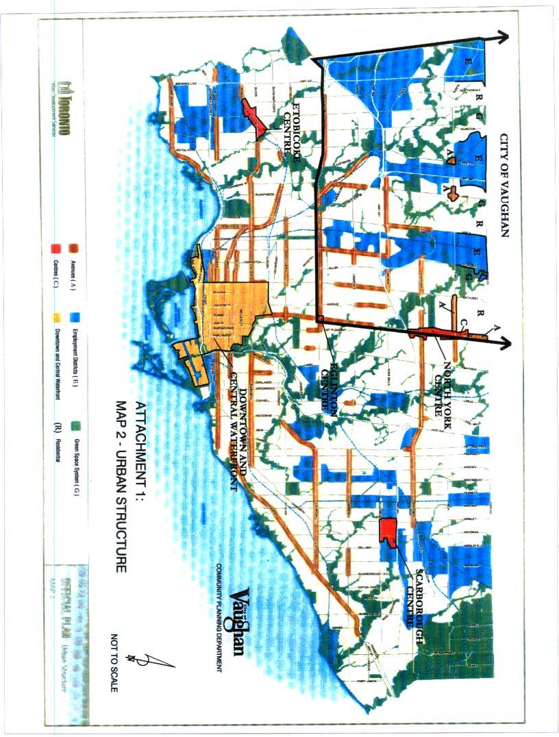
4 h) Overview of Some Major Thematic Elements of the Plan The plan contains a number of important themes, which influence the resulting policies. Some of the more significant themes include: i) Recognition of the City of Toronto s Role in the GTA The plan acknowledges that Toronto cannot plan in isolation of it s neighbours in the Greater Toronto Area. It describes a number of linkages, which must be taken into account in planning the future growth of Toronto. These include: The GTA is a single economy drawing on the strengths and diversity provided by both Toronto and the surrounding regions; Traffic is a cross-boundary issue requiring an integrated inter-regional transportation system featuring, direct and transfer-free transit, efficient road and rail systems for goods movement and access to key locations in the regional economy; Toronto and the GTA are part of the same biophysical region and major trunk services connect municipalities throughout the GTA. When planning for housing the whole of the GTA has to be taken into account; Toronto has a unique social profile in the GTA, with concentrations of new immigrants, post-secondary students and seniors, partially due to the concentration of rental housing and human services. This requires co-operation with municipalities across the GTA in the delivery of services; Toronto is a focal point for a number of services for the whole of the GTA in areas such as culture, healthcare, education, entertainment and retailing. ii) Sustainability and Connectivity The concept of sustainability is entrenched in Toronto s Strategic Plan and was applied in the development of the draft official plan. It is based on the concepts of social equity and inclusion, environmental protection, good government and city building. It encourages decision-making that takes a long-term perspective and it promotes the simultaneous consideration of the economic, social and environmental implications of an action rather than dealing with each as a single issue. The essence of this approach is on understanding how all the systems are connected and function together. This is sometimes known as the ecosystem approach to planning. iii) Reurbanization Reurbanization is one of the main underpinnings of the plan. It is defined as the redevelopment of land within the existing urban fabric in order to accommodate regional growth. This serves to make better use of infrastructure before developing at the fringe, thereby preserving agricultural land, reducing reliance on the car and reducing greenhouse gas emissions. The City of Toronto has virtually exhausted its supply of undeveloped land available to absorb new growth. Therefore, Toronto will need to redevelop parts of the city over the next thirty years to meet its growth targets. iv) Targeted Growth and Change In accommodating the projected growth, the plan anticipates that 75% of the City s land area will be relatively untouched by new growth. The stable areas include lands the plan designates as Neighbourhoods, Apartment Neighbourhoods, Parks and Open Space and Utility Corridors. The remaining 25% of the City s land area would be the preferred target of growth. This would include the Downtown Core, the Central Waterfront Area, four Centres (such as Yonge and
5 Eglinton and North York); strategic Avenues (primarily arterial roads) that are well served by transit; and Employment lands. v) Integration of Land Use and Transportation Critical to the plan s growth strategy is the need to integrate land use and transportation. Generally, growth will be directed to locations where good transit access can be provided, along bus and streetcar routes and at subway stations. The growth areas identified above are all in locations where transit already exists or can be improved to accommodate the planned growth. PART B THE MAJOR LAND USE ELEMENTS a) The Structural Plan (Map 2 Attachment No. 1) The Structural Plan presents the big picture view of the long-term development of the municipality. This establishes the relationships between the major land uses and the accompanying policies provide the road map showing how this vision is going to be achieved. The proposed Urban Structure Plan is shown on Map 2 of the plan (Attachment No. 1). It has six main elements, including the Downtown Core and Central Waterfront; the Centres; the Avenues; Employment Districts; Neighbourhoods and the Green Space System. Each element is described below. i) Downtown The downtown core is perhaps the most visible element of the plan and is to be the subject of its own secondary plan. It is the largest employment centre in the regional economy and provides some 400,000 jobs. The downtown core, anchored by the Financial District, features a widely diversified employment market providing jobs in finance, government, arts and culture, entertainment, tourism, media, education and research and development, often located in specific districts or clusters (e.g. University Avenue Hospitals). In addition, there is a substantial and growing residential component. The plan promotes growth in the downtown core, but recognizes that it will not go to all parts of the downtown. The residential areas will remain largely unaffected. The Financial District is planned as the prime location for new office towers and landmark buildings. A full range of housing opportunities is encouraged. Priority is given to the upgrading of transit services to support the evolution of the downtown area including, improvements at Union Station, giving priority to surface transit services and upgrading the pedestrian system. ii) Centres Four Centres have been identified as locations that could accommodate higher levels of growth, based on substantial past investment in transit and other infrastructure. They include the Scarborough, North York, Eglinton and Etobicoke Centres. The plan proposes creating concentrations of workers and residents at these locations, generating centres of economic activity that are accessible by transit. Each centre will have a secondary plan which will be prepared in accordance with guidelines contained in the official plan. iii) Avenues Avenues are described as important corridors along major streets where reurbanization can yield new housing and employment opportunities, supported by public transit. The public transit should be of high quality, including transit priority measures for buses and streetcars. The intention is to have the Avenues function as main streets and evolve building-by-building. This evolution will be supported by as of right zoning and urban design guidelines. The zoning provisions and urban
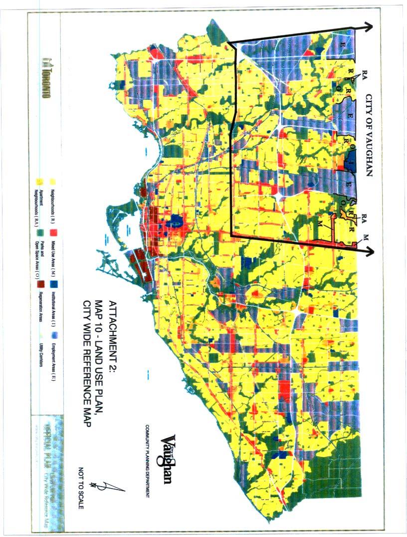
6 design guidelines will emerge from Avenue Studies which will develop the framework for change. iv) Employment Districts The Employment Districts are areas that the plan foresees as accommodating a substantial growth in jobs. They are mainly devoted to manufacturing, warehousing and product assembly, with some functioning as office parks. It is the intent that they be protected from non-economic activities in order to ensure that the needs of business take precedence and that a stable environment develops, which would encourage growth in these areas. This will support the City s tax base and diversify employment opportunities. The plan calls for these areas to be supported through improvements to the transit system, revitalization of declining areas, the promotion of these areas and permitting a broad range of land uses which will facilitate functional linkages amongst businesses (i.e. the clustering of like industries). v) Neighbourhoods The intent of the plan is to provide for the long-term stability of the City s residential neighbourhoods. This will largely be achieved by directing new residential development to the Centres and Avenues. It does recognize that evolution will take place within the neighbourhoods with the provision of infill housing and additions. However, it is a policy of the plan to ensure that new development respects the character of these areas and reinforces their stability. In addition, at the boundary of the growth areas and residential neigbourhoods, new development will be required to demonstrate that there has been a transition in height, density and massing in order to minimize any impacts on the neighbourhood. The plan also identifies a number of measures, which will strengthen the neighbourhoods. These include improved transit enhancement of services and amenities, investment in new facilities and improving and maintaining the public realm. vi) The Green Space System and Waterfront The Green Space System is composed of ravines, beaches, bluffs, parks and cemeteries, which connect to form continuous links across the city. These lands are considered essential to the quality of life in the city and to the health of the natural ecosystems. These areas play many roles in that they provide opportunities for active and passive recreation and perform a wide range of natural functions (e.g. provision of habitat, stormwater management and recharge and aesthetic enhancement). These lands are subject to the Parks and Open Space designation in the plan. It is the policy of the plan that these areas be protected, improved and added to whenever feasible. b) The Land Use Designations (Map 10 Attachment No. 2) In order to implement the structural plan, a total of eight land use designations are proposed. They are divided into two separate classifications. The first group is designed to protect and reinforce the character of stable areas, where growth is not a priority. These designations include Neighbourhoods, Apartment Neighbourhoods, Parks and Open Space Areas, and Utility Corridors. The second group is composed of designations are planned to accept growth. These are the areas to which most of the new population and employment growth will be directed. They are the Mixed Use Areas, Employment Areas, Regeneration Areas and Institutional Areas designations. Unlike many official plans, the land use designations establish the general uses that are to be permitted. It is left to the zoning by-law to provide the development details that are required to permit development to take place. This will require a new comprehensive zoning by-law.
7 This represents a much simplified land use regime for the City of Toronto. It prescribes only eight major building blocks for the City of Toronto. Flexibility within each designation will allow them to accommodate the variety of situations that they will be called upon to regulate. The land use designations are shown on Map 10 the Land Use Plan City Wide Reference Map, which forms Attachment No. 2 to this report. A brief description of the function of the designations is provided below. i) Neighbourhoods The Neighbourhoods designation is applied to residential areas where the uses are contained in buildings of a lower scale, such as detached houses, semi-detached dwellings, duplexes, triplexes, townhouses and interspersed walk-up apartments. This designation also permits lower scale retail, office, service uses along with parks, local institutions, home occupations, cultural and recreational facilities. The plan provides policies respecting the development of new and infill housing and specifies that the zoning by-law will regulate issues such as building type and height, density, lot size, depth and frontage and yard requirements among others. ii) Apartment Neighbourhoods Apartment Neighbourhoods are made up of apartment buildings, parks, local institutions, cultural and recreational facilities and small-scale retail, service and office uses that serve the needs of local residents. Uses permitted in the Neighbourhood designation are also allowed. This designation recognizes existing apartment neighbourhoods scattered throughout the city. These areas are essentially stable and only limited growth is anticipated given the nature of the existing development. The plan does provide development criteria for infill development, which would protect the character and function of adjacent uses. iii) Parks and Open Space Areas Parks and Open Space Areas include the city s valleys, open spaces, watercourses, golf courses, ravines and cemeteries. Development is prohibited in this designation except for recreational and cultural facilities, conservation projects, cemetery uses, public transit and other public works and utilities, subject to an approved environmental assessment. iv) Utility Corridors The Utility Corridors designation mainly includes rail and hydro rights of way. The plan permits the corridors to be used for other purposes, such as parks, pedestrian and bicycle trails, agriculture, parking lots, open storage, public services, stormwater management ponds, transit facilities and garden centres. It also calls for rail corridors to be preserved for future public transportation routes, trails and telecommunication facilities. If a Utility Corridor is declared surplus, the plan provides that they may be purchased or leased for a public use. v) Mixed Use Areas The Mixed Use Area designation permits a wide range of residential uses, offices, retail stores, services, institutions, entertainment uses, recreation and cultural activities and parks and open spaces. The plan proposes that the Mixed Use Areas accommodate much of the planned increase in retail, office and service employment. This designation has been applied to the three main growth related structural designations, being the Downtown, the Centres and the Avenues. Each will develop at different levels of intensity, with different proportions of residential to non-development. Generally, the greatest intensity will be provided in the Downtown core, with lesser densities occurring in the Centres and Avenues. The range of uses will allow people to live, work and shop in the same area, thereby diminishing reliance on their
8 cars. The plan provides development criteria for this designation to protect adjacent neighbourhoods and encourages mixed-use development on underutilized lands in the Downtown, the Central Waterfront and the Centres and Avenues. vi) Employment Areas The Employment Areas are defined as places of business and economic activity. Activities that support this designation include offices, manufacturing, warehousing, distribution, research and development, public utilities, media facilities, parks, hotels, ancillary retail and services that intended to serve the area businesses and workers. Major institutions may locate only on main streets in Employment Areas. Retail warehouses are not permitted in the Central Waterfront Area, but retail warehouses and power centres may be permitted on arterial roads forming a boundary of he Employment Area, subject to a zoning amendment. In order to ensure Toronto s competitive position among city-regions in the global economy, the plan also provides development criteria to ensure that the Employment Areas both function well and appear attractive. vii) Regeneration Areas The purpose of Regeneration Areas is to introduce a wide-range of potential uses to areas that are no longer in productive urban use, due to shifts in the local or international economy. The intent is to help attract investment to these areas and induce the re-use of buildings, encourage new construction and bring life to the streets. Permitted uses would include commercial, residential, light industrial, institutional and live/work style uses. The land use and design solution will depend on the individual area and each response will be developed through the preparation of a secondary plan. Development criteria, for implementation through the secondary plan, are also established for this designation. Options include the preparation of urban design guidelines, environmental policies to encourage site remediation and community improvement strategies. viii) Institutional Areas Institutional Areas include major educational, health and government uses, including their ancillary uses, cultural, parks, and recreational, religious, commercial and residence facilities. The major hospital campuses (e.g. the University Avenue Hospitals), the three major universities (Toronto, York and Ryerson) and the government precincts (Queen s Park and the City of Toronto) serve as examples of these types of uses. These are among the major employers in the City of Toronto and as demand for their services increase, it is expected that they will expand and change. The policies encourage the creation of Campus Plans for major institutional uses, which will allow them to develop quickly when funding becomes available, and identify sites for future expansion. The campus plans are to be developed in consultation with the nearby communities, with a view to minimizing potential conflicts. The campus plans may form the basis for secondary plans. PART C COMMENT AND RECOMMENDATIONS a) Implications for the City of Vaughan This section will provide a discussion of the implications of some of the issues, which may arise over the City of Toronto Official Plan. Where appropriate, comments to the City of Toronto have been recommended. i) Population The City of Toronto has been allocated a projected population increase of 537,000 to the year 2031, which is consistent with past trends. The plan is premised on the fact that it could accommodate substantially more population, perhaps up to 1,000,000 more people. The degree
9 to which the City of Toronto intensifies will be the function of a number of variables. These include; the political acceptability of the intensification of the targeted areas; the degree to which senior levels of government support improved transportation infrastructure to serve the population; continued economic and employment growth; and the ability of the province to control urban sprawl (including protection of the Oak Ridges Moraine) and redirect growth to reurbanizing areas. Parts of the GTA, particularly in south York Region, will be undergoing a similar transition over the next thirty years (e.g. the Highway 7 Corridor). The draft plan s objectives of supporting reurbanization and minimizing dependency on the automobile are sound and are consistent with the policies of the Regional Official Plan. Therefore, in reviewing its investment priorities Toronto should be requested to give significant weight to the GTA-wide impacts of its infrastructure decisions, especially in instances where they would promote objectives similar to those being pursued by Toronto. This type of analysis would need to be considered in the planning and prioritization of transit investments particularly for the northerly service extensions in the City of Toronto that would ultimately reach Steeles Avenue. Examples would include the services in the Spadina and Yonge Street corridors, which are critical to the Region s ability to implement the transportation policies of its official plan and the York Region Transportation Master Plan. These links are also critical to the success of the planned York Region Rapid Transit System. There should be no objection to the population target contained in the draft Toronto Official Plan. Nor should there be any substantial concern about Toronto building in more population capacity through reurbanization. However, any infrastructure investments considered by Toronto to serve existing demand and support the population increase should also take into account their impacts on the surrounding areas. One of the criteria that should be considered is whether such an investment will have a GTA premium. In other words, will it also promote the same objectives being considered in the City of Toronto, such as encouraging compact centres and corridors, an integrated regional transit system and reduced dependency on the automobile? RECOMMENDATION: The City of Toronto BE ADVISED that: 1. The City of Vaughan has no objection to population targets identified in the plan; 2. In prioritizing growth related infrastructure investment, particularly in the area of rapid transit, the City of Toronto is requested to give priority to investments, which would support Regional initiatives, consistent with the objectives of Toronto s plan, in such areas as reurbanization and land use intensification, creation of integrated regional transportation systems, the development of centres and corridors and minimizing dependency on the automobile. ii) Impact of Structural Plan and Land Use Designations The draft Toronto Official Plan largely recognizes the existing development along the common Steeles Avenue boundary. The land uses abutting the City of Vaughan are a mix of the stable designations ( Neighbourhood and Apartment Neighbourhood ) and the growth oriented designations ( Mixed Use and Employment Area ). From Yonge Street to Dufferin Streets the land uses are mainly residential. West of Dufferin Street the lands are primarily designated as Employment Areas, with York University being designated Institutional. West of York University there are small pockets of Residential and Apartment Residential interspersed amongst large tracts of Employment land.
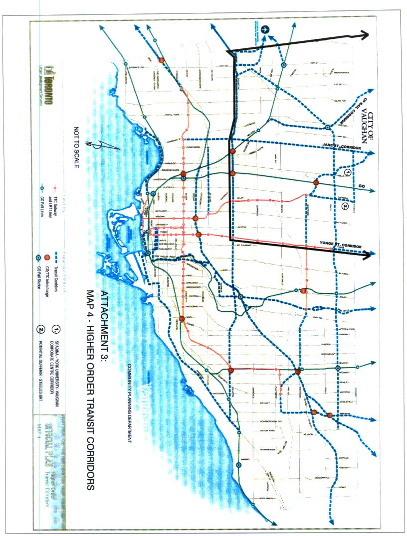
10 In the structural plan, Steeles Avenue is not designated as an Avenue where reurbanization will be promoted. Therefore, it would be assumed that the south side of Steeles Avenue will be relatively stable over the next ten years. Some redevelopment could still take place along the Steeles Avenue frontage in the Employment Areas. Two areas bear watching along the common boundary. The first is York University. While York University is shown as Institutional this area is the subject of a secondary plan, which permits a variety of uses. On June 24, 2002 Vaughan Council gave Staff direction to proceed with a land use study of the north side of Steeles Avenue between Jane and Keele Streets. This is a reaction to the fact that the Region has recently purchased a site for an inter-regional bus terminal that could be used as part of north-south rapid transit service connecting the TTC s Downsview subway station to the Vaughan Corporate Centre. In addition, the TTC has submitted applications for GTIP funding to do environmental assessments for an extension of the Spadina Subway to Steeles Avenue and for an interim Bus Rapid Transit Service. Similarly, the Region of York, with its private-sector partner, will be initiating the Environmental Assessment for long and short term rapid transit measures, which will connect the Vaughan Corporate Centre with Steeles Avenue and York University. The Region has also submitted GTIP applications. Because of the potential for rapid transit improvements to the area, it is anticipated that the University will be re-visiting its land use plans along the south side of Steeles Avenue probably concurrently with the Vaughan study. It is hoped that there can be a high level of co-ordination between all the stakeholders along this length of Steeles Avenue. A second area of consideration could be the Yonge Street and Steeles Avenue intersection. In the early 1990 s Markham, Vaughan, York Region and Toronto (Metro and North York) undertook a joint planning exercise to further the redevelopment of this intersection. Very little came of the venture as there was a downturn in the economy and the prospect of an extension of the Yonge Subway to Steeles Avenue was eliminated as a result of the cancellation of the Metro/TTC s Let s Move program. The draft City of Toronto Official Plan designates Yonge Street, from Finch Avenue to Steeles Avenue as an Avenue in the Structural Plan, which would make it a target for redevelopment. This may have implications in the City of Vaughan in that it could encourage spillover development on the northwest quadrant of the Yonge Street Steeles Avenue intersection. This would be encouraged if Toronto and York Region are successful in implementing rapid transit (Bus Rapid Transit Service) in the Yonge Street corridor as a precursor to a Yonge Subway extension. However, in the short term, it would appear that there will be no significant impacts on the City of Vaughan resulting from the Structural Plan and Land Use Plan set out in the draft Toronto Official Plan. Therefore, there should be no objection to its approval in its present form. RECOMMENDATION: That the City of Toronto BE ADVISED that the City of Vaughan: 1. Has no objection to the Structural Plan and the Land Use Plan established in the draft Official Plan. iii) Transportation and Transit One of the fundamental tenets of the new plan is that the future growth of Toronto will be directed to areas that are well served by transit and the existing road network. A key consideration is the linking of the growth areas through the City s various transportation modes. The key elements include: the subway, LRT, streetcar and bus lines; GO Transit; expressways and major streets; railway corridors; the bikeways; pedestrian links; and hydro corridors.
11 The transportation infrastructure policies address three areas of priority, including: Maintaining a state of good repair; Making better use of existing capacity, particularly by giving priority to streetcars and buses on City roads; and Protecting for incremental expansion of the rapid transit system as demand justifies and funding becomes available. Map 4 (Attachment No. 3) shows the planned Higher Order Transit Corridors and Map 5 (Attachment No. 4) shows the Surface Transit Priority Network. Higher Order Transit Corridors (Map 4 Attachment No. 3) A number of the Higher Order Transit Corridors located in the northwest quadrant of Toronto will directly affect the City of Vaughan. However, no specific technologies have been prescribed. The plan provides that its growth management objectives be supported by, implementing transit services in exclusive rights-or-way in the corridors identified on Map 4 as priorities are established, funding becomes available and the Environmental Assessment review processes are completed. These corridors include: The Spadina-York University-Vaughan Corporate Centre Corridor: South of Steeles Avenue, the alternative route is shown, which varies from the EA approval of the early 1990 s. This abandons the Loop concept, which is consistent with both the Regional and Vaughan Official Plans. The transit corridor shown north of Steeles Avenue is not consistent with OPA No. 529, but it may be conceptually appropriate for an interim Bus Rapid Transit service. This will need to be modified. The Yonge Street Corridor: A transit corridor is shown running north from Finch Station to Steeles Avenue and beyond into York Region. Both York Region and the TTC are investigating a bus rapid transit service in this corridor. The Region is in the final stages of receiving approval from the Ministry of the Environment for the terms of reference for a Yonge Street Transitway Environmental Assessment. Both Toronto and York Region have applied for GTIP funding. Dufferin Street Steeles Avenue Jane Street Corridor: A rapid transit service is shown in this corridor. It would connect the TTC s Downsview Subway Station with the York University and the York Regional Transit Terminal on the north side of Steeles Avenue. The TTC has applied for funding from the GTIP program for funds to do the EA for this service. Jane Street Corridor: This route runs from the Kingsway Subway station on the Bloor- Danforth Line northward into the City of Vaughan Jane Street is one of the TTC s busier surface transit routes. The Finch Hydro Corridor: This corridor runs east-west just north of Finch Avenue from Markham Road on the east to Weston Road, where it swings to the southwest to intersect with Eglinton Avenue. This route is potential competition for a Highway 7 Service in York Region. While it is appropriate to preserve the right of way for potential rapid transit services, its implementation should not be an immediate priority. Part of the Finch Hydro Corridor is being considered as an alternative Bus Rapid Transit alignment, to connect to York University and the Steeles Avenue Transit Terminal, in lieu of the Dufferin Street Steeles Avenue route. CP Rail Corridor: A transit corridor is shown along this rail line extending into the City of Vaughan. In the York Region Transportation Master Plan, this line is shown as providing a future GO Rail service in the long term. The ability of this line to support a Rapid Transit Service, GO Rail and heavy freight traffic would need to be demonstrated. Until more is known about the potential of this line, nothing should be done which would compromise its potential for a GO Rail Service.
12 As noted on Map 4 (Attachment No. 3) there is a wide range of potential transportation projects proposed in the plan. However, the plan does not provide specific guidance on how these investments may be prioritized. Similarly, there is nothing that specifically directs which environmental assessments will be undertaken first. In absence of such criteria the City of Vaughan s suggested priority elements would be the extension of rapid transit services in the Spadina York University Corridor and in the Yonge Street Corridor. Ultimately, these services should be subway extensions, but in the short term interim Bus Rapid Transit services representing a precursor to heavy rail would represent a satisfactory transition. It is noted that the Toronto Transit Commission, on June 12, 2002, reaffirmed its August 29, 2001 position on its Rapid Transit Expansion Study that a Spadina Subway Extension to Steeles Avenue would be one of its two highest priority projects should funding for rapid transit expansion come available. On April 16, 2002 Toronto Council (Report 4, Planning and Transportation Committee, Item 3 Rapid Transit Expansion Study an Spadina York Subway Extension Business Case) adopted the following motion (in part): (5) appropriate City of Toronto and Toronto Transit Commission officials be directed to: i. commence an updated Environmental Assessment study to amend the Yonge-Spadina Subway EA to examine alternate alignments for the extension of the Spadina subway line between Downsview subway station and Steeles Avenue and work with the Region of York to co-ordinate the respective jurisdictions EA studies in this corridor; ii. work with the Region of York to jointly initiate an Environmental Assessment Study to examine the infrastructure and capital requirements to provide an interim express bus route from Downsview subway station to York University and beyond. Toronto Council also included in its motion a statement, which provided that if the new official plan was delayed either through the appeal process or otherwise, that the initiatives with respect to the Spadina Subway extension would still proceed. From the City of Vaughan s perspective, it would be preferred if this commitment of Toronto Council was reflected in the new official plan. RECOMMENDATION: That the City of Toronto BE ADVISED that the City of Vaughan: 1. Supports the extension of rapid transit services in the Spadina-York University- Vaughan Corporate Centre Corridor and in the Yonge Street Corridors, as priority measures and that such services ultimately be heavy rail extensions of the Spadina and Yonge Subway Lines; 2. Supports the implementation of interim Bus Rapid Transit Services in the Yonge and Spadina corridors as a precursor to the subway extensions; 3. Requests that, in the Spadina, York University, Vaughan Corporate Centre Corridor, the plan reflect the route identified north of Steeles Avenue by City of Vaughan OPA No. 529 and the Higher Order Transit Corridor Protection Study ;
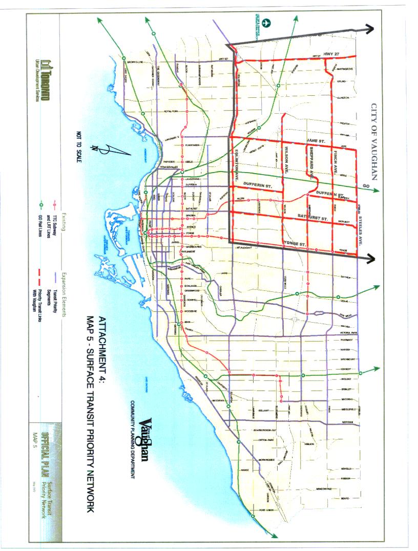
13 4. Supports the Toronto Council resolution of April 16, 2002 and requests that the commitment of City Council to the undertaking of the Environmental Assessment for the Spadina Subway extension between Downsview Station and Steeles Avenue be reflected in the plan; and 5. Has no objection to the CP Rail Corridor being considered for rapid transit, provided that it would not compromise the opportunities for GO Rail services in this corridor. Surface Transit Priority Measures (Map 5 Attachment No. 4) A number of major arterial roads shown on the Surface Transit Priority Network are designated as having Transit Priority Segments. These roads are shown on Map 5 (Attachment No. 4) and include Steeles Avenue, from Jane Street to Yonge Street, Finch and Sheppard Avenues and Jane, Dufferin, Bathurst and Yonge Streets. The policies of the plan support increasing transit priority for surface transit by introducing signal priority at intersections and such other measures as reserved or dedicated bus lanes. Depending on the surface transit priority measure taken, there could be implications for the land uses on the north side of Steeles Avenue, particularly if there are existing accesses, which may be lost. This will have to be monitored in conjunction with the Region of York in order to ensure that the operation of Regional roads, north of Steeles are not affected and that the land uses on the north side of Steeles Avenue are given fair consideration in the planning and implementation of the priority measures. RECOMMENDATION: That the City of Toronto BE ADVISED that the City of Vaughan: 1. Has no objection to the Surface Transit Priority Network shown on Map 5 subject to policies being included in the plan governing criteria for assessing land use impacts resulting from transit priority measures and that policies be provided requiring consultation with adjacent Local and Regional Municipalities on the planning and implementation of such measures. An Agenda for Transportation Change Complementary Policies Like the York Region Transportation Master Plan, the draft Toronto Official Plan recognizes that there will only be limited opportunity to expand the existing road network. As a result the plan supports measures, which will allow the existing infrastructure to be use more efficiently. A number of complementary policies are included that are intended to achieve this objective. These revolve around the concept of Transportation Demand Management (TDM), which is designed to change travel behaviour by encouraging people to take fewer and shorter car trips, increasing the average vehicle occupancy rate and shifting travel times from peak to off-peak hours. Some of the more significant policies include: Requiring transportation impact studies of new developments to identify required improvements and mitigating measures to accommodate the new travel demand, including the introduction of TDM; Planning for new development in targeted growth areas will be undertaken in the context of reducing car dependency; In the area of sites well served by transit consideration will be given to using minimum density requirements, limiting surface parking, minimum and maximum parking requirements and the redevelopment of City-owned parking lots;
14 Making better use of off-street parking by reducing standards for mixed-use development as a result of the uses different peaking requirements; Expanding opportunities for the use of bicycles and walking through expanded and improved bike and pedestrian networks; and Developing a strategy with the trucking industry, the railways, the business community and the public, for the safe, efficient movement of goods through the City s arterial road, expressway and rail networks. These measures are all supportable when applied in the right context. For the development of parcels adjacent to the City of Vaughan, the City would have an opportunity to comment on the development to ensure that the application of such policies would not have a negative effect. In the last point, it is suggested that adjacent municipalities should be consulted where the trucking strategy may result in changed patterns of travel. For example: The City of Vaughan and York Region may be affected if a substantial amount of truck traffic is diverted from part of Toronto onto Highway No For this reason, consultation should be mandatory. RECOMMENDATION: That the City of Toronto BE ADVISED that the City of Vaughan: 1. Has no objection to the complementary policies supporting the integration of land use planning and transportation; 2. Requests that adjacent municipalities be consulted in the preparation of any trucking strategy that may result in changes of travel patterns that may affect the road network or land uses in the adjacent municipalities. iv) Intergovernmental Relationships The first policy put forward in the plan deals with the City of Toronto s relationships with its neighbours in the GTA and the Province of Ontario. It states: 1. Toronto will work with neighbouring municipalities and the Province of Ontario to develop a framework for dealing with growth across the GTA which: a) Focuses urban growth into a pattern of compact centres and corridors connected by an integrated regional transportation system, featuring direct, transfer-free, inter-regional transit service: b) Makes better use of existing urban infrastructure and services; c) Results in better use of existing urban infrastructure and services; d) Reduces auto dependency and improves air quality; e) Increases the efficiency and safety of the road and rail freight networks in the movement of goods and services; f) Encourages rental housing construction to provide a wider choice of housing types; g) Increases the supply of housing in mixed-use environments to create greater opportunities for people to live and work locally; h) Recognizes Pearson Airport as a major hub in the regional economy and improves access for passenger travel and air cargo for all GTA residents and businesses, including convenient transit access to Downtown Toronto; i) Recognizes the importance of Union Station as the major hub in the regional transit system; j) Improves the competitive position of the Toronto Regional economy internationally; and
15 k) Protects, enhances and restores the region s system of green spaces and natural heritage features, the natural ecosystem and the natural corridors that connect these features and protects the Region s prime agricultural land. The idea of developing a framework for dealing with growth across the GTA could be useful. However, there is limited advice in the plan as to how such cross-boundary consultations may be carried out. There is a danger of overlap with other bodies such as the Golden Horseshoe Smart Growth Panel. Unless the approach is well conceived, it could be perceived as a vehicle for interference to abutting jurisdictions, which staff believe is not the City s intent. However, to be effective the framework would need to have a clear mandate and objectives and have buy in from all participants. In May of 2002 the City of Toronto produced a brief entitled Components of a Regional Growth Strategy to Improve the Quality of Life in the Toronto Region for submission to the Federal and Provincial Governments, in response to the Provincial Smart Growth initiatives. It discusses in more detail the components that would be part of the strategy. These largely reflect the matters identified in the official plan policy set out above. It is not clear from the Strategy document how the vision would be implemented. It does indicate that it would need to be implemented by all three levels of government, the private sector, the non-profit and voluntary sectors and the general public. It would be useful if additional information was provided on how such a framework would be implemented. There will also be the need to discuss more detailed land use issues related to specific areas or on-going studies that might affect the area municipalities and the City of Toronto. Developing a forum that provides for on-going contact and consultation between Toronto and the abutting municipalities would be helpful. This should be considered as part of the framework for dealing with development issues in the GTA. RECOMMENDATION: That the City of Toronto BE ADVISED that the City of Vaughan: 1. Does not object to the concept of working with the City of Toronto and other GTA municipalities to develop a framework for dealing with growth across the GTA; 2. Requests that more specific information be provided by the City of Toronto on how the framework for dealing with growth across the GTA would be developed and implemented; 3. Recommends that a means of addressing more detailed implementation issues at the levels of the Regional Municipalities and the Area Municipalities, particularly between abutting municipalities, be considered. Conclusion The draft City of Toronto Official Plan sets out a vision and an implementing policy framework for the development and evolution of Toronto over the next thirty years. The draft official plan is an important document for a number of reasons. In the first instance it is the first comprehensive plan of the newly amalgamated City of Toronto. As such, it will help shape planning and infrastructure investment decisions that may have implications beyond Toronto s boundaries. The plan also marks the formal transition of Toronto to a city where redevelopment, reinvestment and reurbanization will be the sole sources of new growth. In many ways the draft Toronto official plan provides adjacent municipalities in the GTA with a snapshot of the their futures as they develop their remaining greenfield sites. It will be possible
16 to learn from this plan and its implementation on how best to proceed with redevelopment and land use intensification. The City of Vaughan will be facing these types of issues in the near future as it deals with the Highway 7 and Yonge Street corridors, which are major corridors that will be served by rapid transit. The Structural Plan and Land Use Plan largely reflect that the City of Toronto is almost completely built out. Therefore, over the next ten years very few major changes would be anticipated along the Steeles Avenue boundary. A major exception will be York University, which may be amending its secondary plan. Development on the York University campus should be supported as it will promote the extension of rapid services to Steeles Avenue. It is noted that Vaughan has initiated a land use review on the north side of Steeles Avenue, opposite York University. The City of Toronto has identified a number of transit improvements, which will be beneficial to the City of Vaughan, if constructed. In particular the provision of rapid transit (ultimately subways) in the Yonge and Spadina Corridors is essential to the development of the York Region Rapid Transit Plan and the fulfillment of the policies of both the Vaughan and York Region Official Plans. While these are identified, the plan contains no criteria for prioritizing the preparation of the Environmental Assessments and the implementation of the projects. For this reason, it is recommended that the City reiterate its support for the Spadina and Yonge Street rapid transit services. The plan introduces some important concepts in terms of its recognition of the importance of the relationships between the City of Toronto and its partners in the GTA. However, the plan contains limited information on how these relationships might be developed. This will need to be explored further. The draft plan as presented does not present any serious problems for the City of Vaughan. The rapid transit improvements that are key to the City of Vaughan have been shown, although it would have been preferred if there was a stronger commitment to these improvements. Therefore, the comments in this report are largely supportive, subject to a number of qualifications identified in Part 3. Should Council concur, then the recommendations set out in the Recommendation section of this report should be adopted. Attachments 1. Map 2 Urban Structure 2. Map 10 Land Use Plan, City Wide Reference Map 3. Map 4 Higher Order Transit Corridors 4. Map 5 Surface Transit Priority Network Report prepared by: Roy McQuillin, Manager of Corporate Policy, ext 8211 Respectfully submitted, MICHAEL DeANGELIS Commissioner of Planning /CM R:\SER\WORKING\MCQUILLR\TorontoOPJuly22.CW.doc
17
18
19
20
YONGE STEELES CORRIDOR SECONDARY PLAN. Young + Wright / IBI Group Architects Dillon Consulting Ltd. GHK International (Canada) Ltd.
 Ltd.") PART A: PREAMBLE 1.0 PURPOSE The purpose of this Secondary Plan is to provide a development framework for intensification of the Yonge/ Steeles corridor including the north side of Steeles Avenue West
PART A: PREAMBLE 1.0 PURPOSE The purpose of this Secondary Plan is to provide a development framework for intensification of the Yonge/ Steeles corridor including the north side of Steeles Avenue West
9 CITY OF VAUGHAN OFFICIAL PLAN AMENDMENT NO BOCA EAST INVESTMENTS LIMITED
 9 CITY OF VAUGHAN OFFICIAL PLAN AMENDMENT NO. 631 - BOCA EAST INVESTMENTS LIMITED The Planning and Economic Development Committee recommends the adoption of the recommendations contained in the following
CITY CLERK. Parkland Acquisition Strategic Directions Report (All Wards)
") CITY CLERK Clause embodied in Report No. 10 of the, as adopted by the Council of the City of Toronto at its meeting held on November 6, 7 and 8, 2001. 10 Parkland Acquisition Strategic Directions Report
CITY CLERK Clause embodied in Report No. 10 of the, as adopted by the Council of the City of Toronto at its meeting held on November 6, 7 and 8, 2001. 10 Parkland Acquisition Strategic Directions Report
13 THORNHILL YONGE STREET STUDY IMPLEMENTATION CITY OF VAUGHAN OPA 669 AND TOWN OF MARKHAM OPA 154
 13 THORNHILL YONGE STREET STUDY IMPLEMENTATION CITY OF VAUGHAN OPA 669 AND TOWN OF MARKHAM OPA 154 The Planning and Economic Development Committee recommends the adoption of the recommendations contained
Welcome. Walk Around. Talk to Us. Write Down Your Comments
 Welcome This is an information meeting introducing the applications for proposed redevelopment of the Yorkdale Shopping Centre site at 3401 Dufferin Street and 1 Yorkdale Road over the next 20+ years,
THAT the attached Terms of Reference for the Thornhill Centre Street Study be approved.
 COMMITTEE OF THE WHOLE AUGUST 18, 2003 THORNHILL CENTRE STREET STUDY PLANNING FILE: 15.92 Recommendation The Commissioner of Planning recommends: THAT the attached Terms of Reference for the Thornhill
City of Toronto Official Plan Indicators
 City of Toronto Official Plan Indicators Attachment 1 2017 Gladki Planning Associates in association with Hemson Consulting & Studio Jaywall City of Toronto Official Plan Indicators 1 Introduction What
Official Plan Review
 Official Plan Review Summary Report - The Built Environment August 2014 Part 1: Introduction Planning for a healthy, prosperous and sustainable community is an important goal for our municipality. From
Planning and Growth Management Committee. Chief Planner and Executive Director, City Planning Division. Pg12013 (File No NNY 34 OZ)
") 865 York Mills Road Official Plan Amendment Application Preliminary Report STAFF REPORT ACTION REQUIRED Date: February 28, 2012 To: From: Wards: Reference Number: Planning and Growth Management Committee
865 York Mills Road Official Plan Amendment Application Preliminary Report STAFF REPORT ACTION REQUIRED Date: February 28, 2012 To: From: Wards: Reference Number: Planning and Growth Management Committee
CONTENTS 2.0 A FRAMEWORK FOR SUSTAINABLE GROWTH 2.1 MANAGING SUSTAINABLE GROWTH THE VISION TO GOALS AND OBJECTIVES 2.3 MARKHAM STRUCTURE
 2 A Framework for Sustainable Growth 2.0 A FRAMEWORK FOR SUSTAINABLE GROWTH CONTENTS 2.1 MANAGING SUSTAINABLE GROWTH THE VISION TO 2031 2.2 GOALS AND OBJECTIVES 2.2.1 Protecting the Natural Environment
5 TOWN OF MARKHAM OFFICIAL PLAN AMENDMENT NO. 144 MILLIKEN MAIN STREET SECONDARY PLAN
 5 TOWN OF MARKHAM OFFICIAL PLAN AMENDMENT NO. 144 MILLIKEN MAIN STREET SECONDARY PLAN The Planning and Economic Development Committee recommends the following: 1. The communication from Brendan O Callaghan,
SCARBOROUGH SUBWAY EXTENSION. Scarborough Subway Extension. Final Terms of Reference
 Scarborough Subway Extension Final Terms of Reference 1 1.0 Introduction and Background 1.1 Introduction Toronto City Council recently confirmed support for an extension of the Bloor-Danforth Subway from
and services The protection and conservation of environmentally significant and sensitive natural heritage features and functions.
 6. Land Use 6.0 Preamble A healthy and livable city is one in which people can enjoy a vibrant economy and a sustainable healthy environment in safe, caring and diverse neighbourhoods. In order to ensure
Sustainable Growth. Sustainable Growth
 2 Sustainable Growth Sustainable Growth SUSTAINABLE GROWTH 2.1 COMMUNITY VISION... 2-5 2.2 THE CITY SYSTEM... 2-7 2.2.1 AREAS... 2-7 2.2.2 CITY-WIDE SYSTEMS... 2-8 2.2.3 PROVINCIAL PLAN BOUNDARIES AND
Bloor St. W. Rezoning - Preliminary Report
 STAFF REPORT ACTION REQUIRED 1638-1644 Bloor St. W. Rezoning - Preliminary Report Date: April 1, 2008 To: From: Wards: Reference Number: Toronto and East York Community Council Acting Director, Community
Eglinton Avenue East & 50 Thermos Road - Official Plan Amendment Application Preliminary Report
 STAFF REPORT ACTION REQUIRED 1966 2050 Eglinton Avenue East & 50 Thermos Road - Official Plan Amendment Application Preliminary Report Date: March 15, 2016 To: From: Wards: Reference Number: Scarborough
2.0 A FRAMEWORK FOR SUSTAINABLE GROWTH CONTENTS
 2-2 A Framework for Sustainable Growth 2.0 A FRAMEWORK FOR SUSTAINABLE GROWTH CONTENTS 2.1 MANAGING SUSTAINABLE GROWTH THE VISION TO 2031 2.2 GOALS AND OBJECTIVES 2.2.1 Protecting the Natural Environment
CITY OF LANGLEY OFFICIAL COMMUNITY PLAN BYLAW, 2005, NO APPENDIX II - REGIONAL CONTEXT MAP
 CITY OF LANGLEY OFFICIAL COMMUNITY PLAN BYLAW, 2005, NO. 2600 APPENDIX II - REGIONAL CONTEXT MAP ± Legend Agricultural Mixed Employment Industrial Conservation & Recreation Regional City Centre Urban Containment
Report to: Development Services Committee Report Date: September 11, 2017
 ~RKHAM Report to: Development Services Committee Report Date: September 11, 2017 SUBJECT: PREPARED BY: Conceptual Master Plan for the Future Urban Area - Community Structure Plan and Key Policy Direction
1.0 PLANNING MARKHAM S FUTURE CONTENTS
 1-1 Planning Markham s Future 1.0 PLANNING MARKHAM S FUTURE CONTENTS 1.1 THE PURPOSE OF THE OFFICIAL PLAN 1.2 THE MARKHAM CONTEXT 1.3 THE REGULATORY CONTEXT 1.3.1 Province of Ontario 1.3.2 York Region
and Richmond Street West - Official Plan Amendment Application - Preliminary Report
 STAFF REPORT ACTION REQUIRED 822-838 and 860-862 Richmond Street West - Official Plan Amendment Application - Preliminary Report Date: August 14, 2017 To: From: Wards: Reference Number: Toronto and East
The Corporation of the Town of Milton
 Report To: From: Council Barbara Koopmans, Commissioner, Planning and Development Date: May 7, 2018 Report No: Subject: Making it Possible Positioning the Town s Strategy for Growth and Economic Development
Official Plan Review: Draft Built Form Policies
 PG.30.1 REPORT FOR ACTION Official Plan Review: Draft Built Form Policies Date: May 15, 2018 To: Planning and Growth Management Committee From: Chief Planner and Executive Director, City Planning Division
11.4 Highway 400 North Employment Lands Secondary Plan APPROVED BY THE ONTARIO MUNICIPAL BOARD ON NOVEMBER 21, 2011
 11.4 Highway 400 North Employment Lands Secondary Plan APPROVED BY THE ONTARIO MUNICIPAL BOARD ON NOVEMBER 21, 2011 11.4.1 General 11.4.1.1. as approved by the Ontario Municipal Board on November 21, 2011,
DAVENPORT VILLAGE SECONDARY PLAN
 27 DAVENPORT VILLAGE SECONDARY PLAN 27. DAVENPORT VILLAGE SECONDARY PLAN 1. VISION FOR THE DAVENPORT VILLAGE SECONDARY PLAN Davenport Village, municipally known as 830, 940, 980 and 1100 Lansdowne Avenue,
[PLANNING RATIONALE] For Site Plan Control and Lifting of Holding Zone By-Law 101 Champagne Avenue. May 23, 2014
![[PLANNING RATIONALE] For Site Plan Control and Lifting of Holding Zone By-Law 101 Champagne Avenue. May 23, 2014](/thumbs/75/71599615.jpg "[PLANNING RATIONALE] For Site Plan Control and Lifting of Holding Zone By-Law 101 Champagne Avenue. May 23, 2014") [PLANNING RATIONALE] For Site Plan Control and Lifting of Holding Zone By-Law 101 Champagne Avenue May 23, 2014 Contents 1.0 Introduction... 2 2.0 Site Context... 2 2.1 Adjacent Uses... 2 Figure 1: Site
[PLANNING RATIONALE] For Site Plan Control and Lifting of Holding Zone By-Law 101 Champagne Avenue May 23, 2014 Contents 1.0 Introduction... 2 2.0 Site Context... 2 2.1 Adjacent Uses... 2 Figure 1: Site
4. LAND USE DESIGNATIONS
 4. LAND USE DESIGNATIONS Land use designations are among the Official Plan s key implementation tools for achieving the growth strategy set out in Chapter Two to direct major growth to some parts of the
2.0 A FRAMEWORK FOR SUSTAINABLE GROWTH CONTENTS
 2-2 A Framework for Sustainable Growth 2.0 A FRAMEWORK FOR SUSTAINABLE GROWTH CONTENTS 2.1 MANAGING SUSTAINABLE GROWTH THE VISION TO 2031 2.2 GOALS AND OBJECTIVES 2.2.1 Protecting the Natural Environment
12 AMENDMENT NO. 149, TOWN OF MARKHAM HIGHWAY 404 NORTH SECONDARY PLAN
 12 AMENDMENT NO. 149, TOWN OF MARKHAM HIGHWAY 404 NORTH SECONDARY PLAN The Planning and Economic Development Committee recommends the adoption of the recommendation contained in the following report August
A Growing Community Rural Settlement Areas
 Town of Huntsville Official Plan Review - POLICY BACKGROUND PAPER A Growing Community Rural Settlement Areas BACKGROUND: In addition to the fully municipally-serviced Urban Settlement Area and the Hidden
3 TOWN OF WHITCHURCH-STOUFFVILLE OFFICIAL PLAN AMENDMENT NOS. 116 & 117
 3 TOWN OF WHITCHURCH-STOUFFVILLE OFFICIAL PLAN AMENDMENT NOS. 116 & 117 The Planning and Economic Development Committee recommends the adoption of the recommendations contained in the following report,
WITNESS STATEMENT Of. Ronald Blake. On behalf of the Intervenor The Corporation of the City of Markham
 Filed: 2013-06028 EB-2012-0451 Exhibit L.EGD.COM.2 Page 1 of 7 WITNESS STATEMENT Of Ronald Blake On behalf of the Intervenor The Corporation of the City of Markham In the matter of an application by Enbridge
AGINCOURT SECONDARY PLAN
 1 AGINCOURT SECONDARY PLAN 1. AGINCOURT SECONDARY PLAN The following policies and principles apply to the area herein referred to as Agincourt, as outlined on Map 1-1. 1. GENERAL POLICIES 1.1 This Secondary
CITY COUNCIL AGENDA REPORT
 CITY COUNCIL AGENDA REPORT Subject: COUNCIL MOTION LRT ALIGNMENT REMOVAL FROM THE TRANSPORTATION MASTER PLAN On February 10, 2016 Councillor Hughes provided notice in accordance with Section 23 of Procedure
PUBLIC OPEN HOUSE HURONTARIO-MAIN CORRIDOR SECONDARY PLAN
 PUBLIC OPEN HOUSE HURONTARIO-MAIN CORRIDOR SECONDARY PLAN Tuesday, February 28, 2012 6pm 9pm 1 st Floor Atrium, City Hall 2 Wellington Street West, Brampton 1 POLICY FRAMEWORK The 2006 Provincial Growth
1 Introduction. Chapter. In this chapter:
 Chapter 1 Introduction In this chapter: 1.1 A Snapshot of the Region 1.2 Towards a Sustainable Region 1.3 The Provincial Context 1.4 Purpose and Organization The Regional Municipality of York Official
2. SHAPING THE CITY URBAN REGION 2.1 BUILDING A MORE LIVEABLE
 2. SHAPING THE CITY Toronto s future is one of growth, of rebuilding, of reurbanizing and of regenerating the City within an existing urban structure that is not easy to change. Population growth is needed
178 Carruthers Properties Inc.
 178 Carruthers Properties Inc. Planning Rationale for 178 Carruthers Avenue Site Plan Control Application June 2014 Table of Contents 1.0 Introduction 2.0 Overview of Subject Property 3.0 Current Zoning
1. MAKING CHOICES. What kind of city will Toronto be in the 21st century?
 1. MAKING CHOICES Toronto is a great city! It has evolved into a special place that people care about deeply. It is a wonderful city in which to live, offering a diversity and richness of urban life that
Urban Design Manual PLANNING AROUND RAPID TRANSIT STATIONS (PARTS) Introduction. Station Study Areas
 Introduction. Station Study Areas") 111111 PLANNING AROUND RAPID TRANSIT STATIONS (PARTS) Introduction The ION rapid transit system will link Waterloo, Kitchener and Cambridge through a central transit corridor (CTC). There are a number
111111 PLANNING AROUND RAPID TRANSIT STATIONS (PARTS) Introduction The ION rapid transit system will link Waterloo, Kitchener and Cambridge through a central transit corridor (CTC). There are a number
CONTENTS 8.0 LAND USE 8.1 GENERAL LAND USE 8.2 RESIDENTIAL 8.3 MIXED USE 8.4 COMMERCIAL 8.5 EMPLOYMENT LANDS
 8-2 Land Use 8.0 LAND USE CONTENTS 8.1 GENERAL LAND USE 8.1.1 Uses provided for in all Land Use Designations 8.1.2 Uses prohibited in Hazardous Lands, Hazardous Sites and Special Policy Areas 8.1.3 Uses
4780 Eglinton Avenue West - Zoning By-law Amendment and Draft Plan of Subdivision Applications - Preliminary Report
 STAFF REPORT ACTION REQUIRED 4780 Eglinton Avenue West - Zoning By-law Amendment and Draft Plan of Subdivision Applications - Preliminary Report Date: May 29, 2014 To: From: Wards: Reference Number: Etobicoke
Trafalgar Road Corridor Planning Study Open House
 Trafalgar Road Corridor Planning Study Open House June 24, 2013 6:30-8:30 p.m. Oakville & Trafalgar Rooms Overview The Livable Oakville Plan identifies the lands along Trafalgar Road, between the QEW and
New Official Plan Quest November 2013
 City of Markham New Official Plan Quest November 2013 Building Markham s Future Together - 6 Key Strategic Priorities 1. Growth - Managing our Growth 2. Transportation/Transit - Improving transportation
2.2.1 DOWNTOWN: THE HEART OF TORONTO
 2.2.1 DOWNTOWN: THE HEART OF TORONTO Toronto has only one downtown. It plays a vital role as the city s economic and cultural hub and is critical to the health and prosperity of the entire region that
Director, Community Planning, Etobicoke York District
 STAFF REPORT ACTION REQUIRED Baby Point Gates Planning Study 227-430 Jane Street, 665-685 Annette Street, 494 Armadale Avenue, 143 Evans Avenue and 502 504 Willard Avenue Status Report Date: August 11,
Planning Department. Director of Planning. Manager of Planning. Planning Technician/ Sustainability Coordinator. Planner II/ Heritage Coordinator
 Department Director of Manager of Policy Planner Planner II (2) Planner II/ Heritage Coordinator Technician/ Sustainability Coordinator Technician Administrative Clerk March 2017 Department 2018 Business
Finch Avenue West and Sheppard Avenue East Corridors - Planning Study Approach. Planning and Growth Management Committee
 PG8.9 STAFF REPORT ACTION REQUIRED Finch Avenue West and Sheppard Avenue East Corridors - Planning Study Approach Date: October 13, 2015 To: From: Planning and Growth Management Committee Chief Planner
Queen Street West - Zoning Amendment Application - Preliminary Report
 STAFF REPORT ACTION REQUIRED 944-952 Queen Street West - Zoning Amendment Application - Preliminary Report Date: February 6, 2013 To: From: Wards: Reference Number: Toronto and East York Community Council
The transportation system in a community is an
 7 TRANSPORTATION The transportation system in a community is an important factor contributing to the quality of life of the residents. Without a sound transportation system to bring both goods and patrons
SUBJECT: GO Station Mobility Hubs Preferred Concepts: Aldershot GO, Burlington GO and Appleby GO. Planning and Development Committee - Public Meeting
 Page 1 of Report PB-76-17 SUBJECT: GO Station Mobility Hubs Preferred Concepts: Aldershot GO, Burlington GO and Appleby GO TO: FROM: Planning and Development Committee - Public Meeting Planning and Building
Coordinated Transit Planning in Toronto SmartTrack GO RER Scarborough Relief Line Waterfront Transit
 Coordinated Transit Planning in Toronto SmartTrack GO RER Scarborough Relief Line Waterfront Transit Public Information Centres February 2016 Transportation Planning Section City Planning Division Toronto
CITY OF VAUGHAN EXTRACT FROM COUNCIL MEETING MINUTES OF NOVEMBER 15, 2016
 Item 11, Report No. 38, of the Committee of the Whole, which was adopted without amendment by the Council of the City of Vaughan on November 15, 2016. Regional Councillor Di Biase declared an interest
11.4 Highway 400 North Employment Lands Secondary Plan
 11.4 Highway 400 North Employment Lands Secondary Plan APPROVED BY THE ONTARIO MUNICIPAL BOARD ON NOVEMBER 21, 2011 11.4.1 General 11.4.1.1. The following policies and Schedules A - I form Official Plan
PSRC REVIEW REPORT & CERTIFICATION RECOMMENDATION
 PSRC REVIEW REPORT & CERTIFICATION RECOMMENDATION KITSAP COUNTY COUNTYWIDE PLANNING POLICIES July 2, 2012 BACKGROUND A major emphasis of the Washington State Growth Management Act (GMA) is the need to
CITY OF VAUGHAN EXTRACT FROM COUNCIL MEETING MINUTES OF OCTOBER 24, 2017
 CITY OF VAUGHAN EXTRACT FROM COUNCIL MEETING MINUTES OF OCTOBER 24, 2017 Item 1, Report No. 35, of the Committee of the Whole, which was adopted without amendment by the Council of the City of Vaughan
The West Vaughan Employment Area Secondary Plan Policies
 Part 2: The West Vaughan Employment Area Secondary Plan Policies 2.1 General Policies It is the policy of Council: 2.1.1. That the West Vaughan Employment Area (the WVEA), identified on Schedule 1, will
2450 Victoria Park Avenue Official Plan Amendment Application Preliminary Report
 STAFF REPORT ACTION REQUIRED 2450 Victoria Park Avenue Official Plan Amendment Application Preliminary Report Date: December 19, 2012 To: From: Wards: Reference Number: Planning and Growth Management Committee
THE CITY OF VAUGHAN BY-LAW BY-LAW NUMBER A By-law to adopt Amendment Number 1 to the Official Plan of the Vaughan Planning Area.
 THE CITY OF VAUGHAN BY-LAW BY-LAW NUMBER 015-2014 A By-law to adopt Amendment Number 1 to the Official Plan of the Vaughan Planning Area. NOW THEREFORE the Council of the Corporation of the City of Vaughan
Relief Line Project Assessment
 Relief Line Project Assessment Public Information Centre April 5, 2017 Tonight s Meeting PURPOSE To review the preferred alignment for the Local Segment. AGENDA 6:30 Open House 7:00 Presentation / Discussion
QUEEN-RIVER SECONDARY PLAN
 34 QUEEN-RIVER SECONDARY PLAN 34. QUEEN RIVER SECONDARY PLAN 1. INTRODUCTION The Queen-River area is approximately 6.4 hectares and is located at the eastern edge of the Downtown as shown on Map 34-1.
THE GARDEN CITY PLAN. City of St. Catharines Official Plan. City of St. Catharines
 THE GARDEN CITY PLAN City of St. Catharines Official Plan City of St. Catharines August 2010 APPROVAL INFORMATION This Official Plan of the City of St. Catharines Planning Area, known as the Garden City
646 Kingston Road - Official Plan Amendment and Zoning Amendment Applications - Preliminary Report
 STAFF REPORT ACTION REQUIRED 646 Kingston Road - Official Plan Amendment and Zoning Amendment Applications - Preliminary Report Date: December 8, 2014 To: From: Wards: Reference Number: Toronto and East
1.3 TRANSIT VISION 2040 FROM VISION TO ACTION THEME 1: PUTTING TRANSIT AT THE CENTRE OF COMMUNITIES. Fully integrate transit with community planning
 TRANSIT VISION 2040 FROM VISION TO ACTION TRANSIT VISION 2040 defines a future in which public transit maximizes its contribution to quality of life with benefits that support a vibrant and equitable society,
This page has been intentionally left blank.
 This page has been intentionally left blank. Chapter 3 3-2 3. Employment 3.A Niagara Economic Gateway 3.A.1 General The Niagara Economic Gateway comprises: a) The Gateway Economic Zone which includes all
2 STATUTORY PUBLIC MEETING AND INFORMATION REPORT FOR PUBLIC MEETING ON AMENDMENT NO. 62 TO THE YORK REGION OFFICIAL PLAN
 2 STATUTORY PUBLIC MEETING AND INFORMATION REPORT FOR PUBLIC MEETING ON AMENDMENT NO. 62 TO THE YORK REGION OFFICIAL PLAN Pursuant to Section 17(15) of the Planning Act, as amended, the Regional Planning
K. SMART ASSOCIATES LIMITED
 Planning Justification Report Zoning By-Law Amendment 185 King Street North Waterloo, Ontario April 7th, 2017 Project Reference Number 16-245 K. SMART ASSOCIATES LIMITED CONSULTING ENGINEERS AND PLANNERS
770 Don Mills Road and 805 Don Mills Road - Official Plan Amendment and Zoning By-law Amendment Application Preliminary Report
 REPORT FOR ACTION 770 Don Mills Road and 805 Don Mills Road - Official Plan Amendment and Zoning By-law Amendment Application Preliminary Report Date: To: From: Wards: June 22, 2018 North York Community
City-Initiated Official Plan and Zoning By-law Amendments, Yonge-Eglinton Centre Focused Review Final Report
 STAFF REPORT ACTION REQUIRED City-Initiated Official Plan and Zoning By-law Amendments, Yonge-Eglinton Centre Focused Review Final Report Date: January 5, 2009 To: From: Planning and Growth Management
1.0 Purpose of a Secondary Plan for the Masonville Transit Village
 Report to Planning and Environment Committee To: Chair and Members Planning & Environment Committee From: John M. Fleming Managing Director, Planning and City Planner Subject: Masonville Transit Village
38 Queen s University Campus Master Plan Part 1
 38 Queen s University Campus Master Plan Part 1 46 The Campus at the City Scale Chapter 4 The Campus at the City Scale 39 Queen s is an urban University centrally located in Kingston. Decisions made by
Town of Cobourg Heritage Master Plan. Statutory Public Meeting
 Town of Cobourg Heritage Master Plan Statutory Public Meeting April 25 th 2016 Presentation Overview 1. Introduction 2. Project background and schedule overview 3. Review of strategic direction content
ELMVALE ACRES SHOPPING CENTRE MASTER PLAN
 ELMVALE ACRES SHOPPING CENTRE MASTER PLAN Contents 1.0 INTRODUCTION... 2 2.0 LOCATION... 2 3.0 EXISTING CONTEXT... 2 4.0 VISION & GUIDING PRINCIPLES... 2 5.0 LAND USE AND BUILT FORM... 4 5.1 St. Laurent
Hurontario/Main Street Corridor Master Plan Mississauga and Brampton Building a new and integrated vision for the corridor
 Hurontario/Main Street Corridor Master Plan Mississauga and Brampton Building a new and integrated vision for the corridor Martin Powell, Commissioner of Transportation and Works, City of Mississauga Paper
Message from York Regional Council
 Tom Taylor Town of Newmarket Tim Jones Town of Aurora James Young Town of East Gwillimbury Robert Grossi Town of Georgina Danny Wheeler Town of Georgina Margaret Black Township of King A.J. (Tony) Van
6 Growth Management Challenges and Opportunities
 6 Growth Management Challenges and Opportunities The Town has established a goal of attaining a 50% participation rate with respect to employment opportunities versus residential population. The Town s
Director, Community Planning, North York District
 STAFF REPORT ACTION REQUIRED Oakwood Avenue Arts District Official Plan Amendment Final Report Date: September 12, 2008 To: From: Wards: Reference Number: North York Community Council Director, Community
Draft Urban Hamilton Official Plan. Amendment No. XX
 1 of 75 The following text, together with: Draft Appendix A Appendix B Volume 1, Schedule E-1 Urban Land Use Designations Appendix C Volume 1, Appendix A Parks Classification Map Appendix D Volume 1, Appendix
PART 1. Background to the Study. Avenue Study. The Danforth
 The Danforth 1.1/ Study Purpose & Key Municipal Goals 1.2/ The Local Advisory Committee 1.3/ The Project Team 1.4/ Study Process/Summary of Method 1.5/ Summary of Consultation 1.1 Study Purpose and Key
PORT WHITBY COMMUNITY
 PORT WHITBY COMMUNITY SECONDARY PLAN UPDATE COMMUNITY IMPROVEMENT PLAN URBAN DESIGN GUIDELINES September 2015 DRAFT PROPOSED AMENDMENT NUMBER # to the Whitby Official Plan PURPOSE: The intent of this Amendment
FORMER CANADIAN FORCES BASE (CFB) ROCKCLIFFE SECONDARY PLAN. Official Plan Amendment XX to the Official Plan for the City of Ottawa
 ROCKCLIFFE SECONDARY PLAN. Official Plan Amendment XX to the Official Plan for the City of Ottawa") FORMER CANADIAN FORCES BASE (CFB) ROCKCLIFFE SECONDARY PLAN Official Plan Amendment XX to the Official Plan for the City of Ottawa 1 INDEX THE STATEMENT OF COMPONENTS PART A THE PREAMBLE PAGE Purpose...
FORMER CANADIAN FORCES BASE (CFB) ROCKCLIFFE SECONDARY PLAN Official Plan Amendment XX to the Official Plan for the City of Ottawa 1 INDEX THE STATEMENT OF COMPONENTS PART A THE PREAMBLE PAGE Purpose...
Brampton. Secondary Plan. Review. Bram West. A New Direction in Planning & Public Consultation
 Brampton Bram West Secondary Plan Review A New Direction in Planning & Public Consultation Introduction The Bram West Secondary Plan Review offers an important opportunity for the community to define a
Chairman and Members of the Planning and Development Committee. Thomas S. Mokrzycki, Commissioner of Planning and Building
 LA.09.TOR (Toronto) DATE: TO: FROM: SUBJECT: Chairman and Members of the Planning and Development Committee Thomas S. Mokrzycki, Commissioner of Planning and Building Central Waterfront Secondary Plan
WELCOME. The Yonge-Eglinton area has experienced significant growth and change in the last decade.
 WELCOME DID YOU KNOW? MIDTOWN IS REPRESENTED BY 3 CITY COUNCILLORS: WARD 16 EGLINTON-LAWRENCE WARD 22 ST. PAUL S WARD 25 DON VALLEY WEST Midtown in Focus: Building a Livable Yonge-Eglinton The Yonge-Eglinton
Figure 1- Site Plan Concept
 Figure 1- Site Plan Concept Parking will be provided underground on three levels at rate of 1.0 space/ unit; this rate includes all visitors parking. MMM Group has prepared a parking assessment (April,
Transforming Saint John s Urban Heart -
 Transforming Saint John s Urban Heart - How Innovative Community Engagement Inspires a Bold Municipal Plan for a More Sustainable and Compact Saint John 2012 NNECAPA Conference - Brunswick, ME October
808 Mount Pleasant Road Zoning Amendment Application Request for Interim Direction Report
 STAFF REPORT ACTION REQUIRED 808 Mount Pleasant Road Zoning Amendment Application Request for Interim Direction Report Date: June 15, 2018 To: From: Wards: Reference Number: Toronto and East York Community
HEMSON IV EMPLOYMENT LAND CONVERSION
 28 IV EMPLOYMENT LAND CONVERSION The appropriateness of permitting changes to the City s employment land supply is considered within the context of the adequacy of the supply to accommodate growth projected
Land Use Amendment in Southwood (Ward 11) at and Elbow Drive SW, LOC
 at and Elbow Drive SW, LOC") 2018 November 15 Page 1 of 10 EXECUTIVE SUMMARY This land use amendment application was submitted by Rick Balbi Architect on 2017 August 31 on behalf of Sable Developments Ltd, and with authorization from
2018 November 15 Page 1 of 10 EXECUTIVE SUMMARY This land use amendment application was submitted by Rick Balbi Architect on 2017 August 31 on behalf of Sable Developments Ltd, and with authorization from
COMMUNITY SUSTAINABILITY AND ENVIRONMENTAL MASTER PLAN IMPLEMENTATION UPDATE
 Attachment 1 COMMUNITY SUSTAINABILITY AND ENVIRONMENTAL MASTER PLAN IMPLEMENTATION UPDATE Priorities and Key Initiatives Committee May 2013 Page E-1 How we grow Goal 2: To ensure sustainable development
John M. Fleming Managing Director, Planning and City Planner. Old East Village Dundas Street Corridor Secondary Plan Draft Terms of Reference
 Report to Planning and Environment Committee To: From: Subject: Chair and Members Planning & Environment Committee John M. Fleming Managing Director, Planning and City Planner Old East Village Dundas Street
1071 King Street West Zoning Amendment Application - Preliminary Report
 STAFF REPORT ACTION REQUIRED 1071 King Street West Zoning Amendment Application - Preliminary Report Date: August 9, 2012 To: From: Wards: Reference Number: Toronto and East York Community Council Director,
4800 Yonge Street - Official Plan Amendment, Zoning Amendment and Site Plan Applications - Request for Direction Report
 STAFF REPORT ACTION REQUIRED 4800 Yonge Street - Official Plan Amendment, Zoning Amendment and Site Plan Applications - Request for Direction Report Date: April 16, 2018 To: From: Wards: Reference Number:
ONTARIO MUNICIPAL BOARD
 PL 120483 ONTARIO MUNICIPAL BOARD Applicant/Appellant: 2124123 Ontario Limited Subject: OPA, Rezoning and Draft Plan of Subdivision Municipal Address: 3940 Highway 7 East Municipality: City of Markham
NEW REGIONAL OFFICIAL PLAN HIGH LEVEL PROCESS & FRAMEWORK
 NEW REGIONAL OFFICIAL PLAN HIGH LEVEL PROCESS & FRAMEWORK Why A New Official Plan Originally the role of Regionally Planning and content of Regional Official Plan (1970s) primarily focused on protecting
8 Oak Street - Official Plan and Zoning By-law Amendment Application - Preliminary Report
 STAFF REPORT ACTION REQUIRED 8 Oak Street - Official Plan and Zoning By-law Amendment Application - Preliminary Report Date: March 17, 2014 To: From: Wards: Reference Number: Planning and Growth Management
Director, Community Planning, Toronto and East York District
 Lower Yonge Precinct Plan Update STAFF REPORT ACTION REQUIRED Date: October 16, 2012 To: From: Wards: Reference Number: Toronto and East York Community Council Director, Community Planning, Toronto and
3 MARKHAM NORTH-SOUTH LINK CORRIDOR PUBLIC TRANSIT IMPROVEMENTS ENVIRONMENTAL ASSESSMENT UPDATE
 3 MARKHAM NORTH-SOUTH LINK CORRIDOR PUBLIC TRANSIT IMPROVEMENTS ENVIRONMENTAL ASSESSMENT UPDATE The Rapid Transit Public/Private Partnership Steering Committee recommends the adoption of the recommendations
Background Summary Report
 Background Summary Report May 2014 Submitted by Macaulay Shiomi Howson Ltd. In association with AMEC MMM Group Brook McIlroy Inc. Hemson Consulting Ltd. Table of Contents 1. Introduction... 1 2. Why is
City of Toronto. Emery Village Transportation Master Plan
 City of Toronto Emery Village Transportation Master Plan May 2009 Emery Village Transportation Master Plan Toronto, ON May 2009 Consulting Inc. 100 York Blvd., Suite 300 Richmond Hill, ON L4B 1J8 Tel: