Subdivision Staff Report
|
|
|
- MargaretMargaret Wiggins
- 5 years ago
- Views:
Transcription

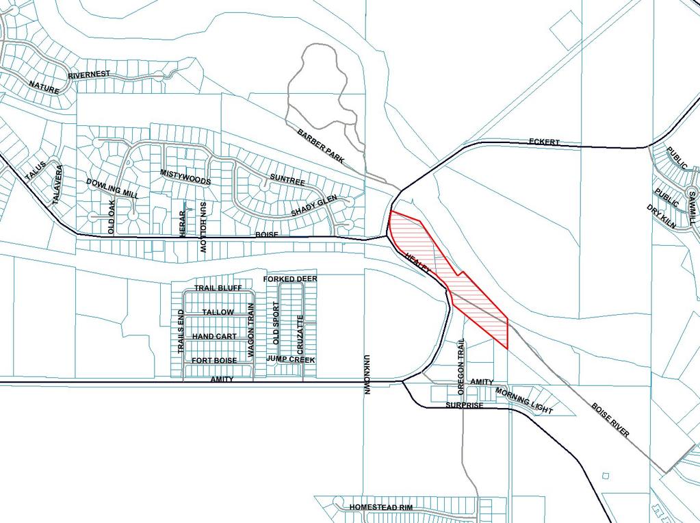
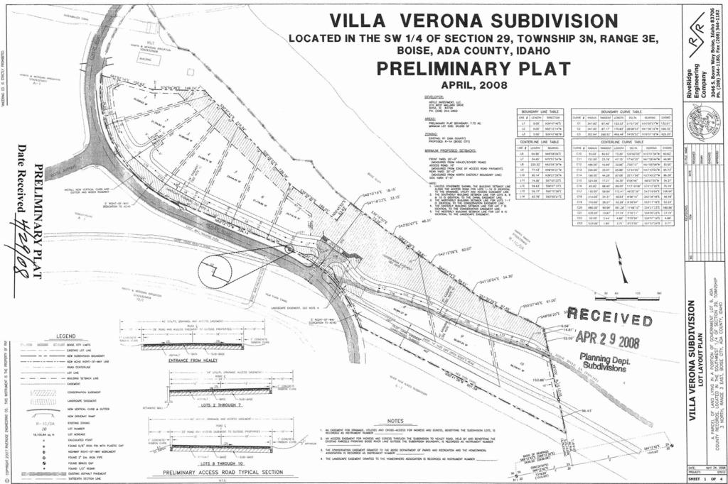
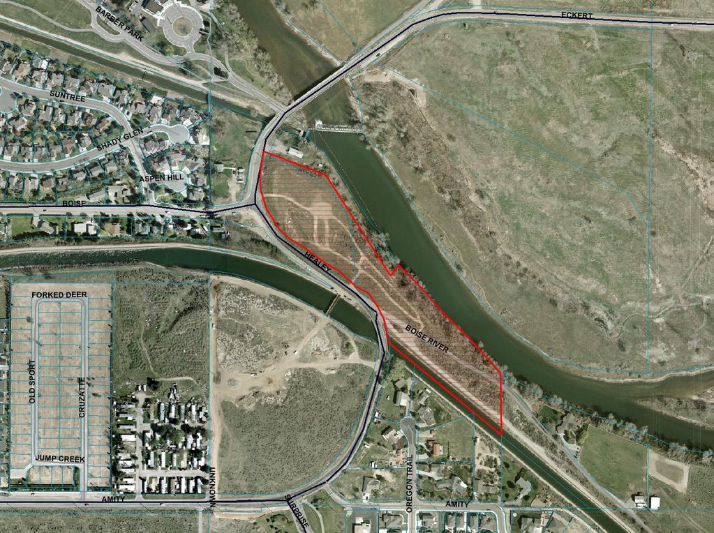
1 Subdivision Staff Report Subdivision Name Villa Veneto Subdivision File Number SUB Approval Preliminary Plat Lead Agency Boise City Annexation Date Pending (CAR /DA) Comp. Plan Does Not Comply Public Hearing Date November 18, 2008 Heard by Boise City Council Planning and Zoning Commission Denial August 11, 2008 Analyst Joan Johnson Description: This is a proposed single family residential subdivision with 10 buildable lots on 7.72 acres. The density of the subdivision is 2.3 buildable lots per acre. The subject property is currently vacant. The subject property has an Ada County zoning designation of R-1 (Estate Residential). This subdivision is subject to approval of six companion applications: annexation with a rezone and development agreement to R-1A/DA (CAR /DA), comprehensive plan amendment (CAR ), Boise River System (CFH ), Hillside permit (CFH ), Conditional Use Permit for a 10 unit planned residential development (CUP ) and Variance to reduce the 200 bald eagle setback (CVA ). The subject property is located on the south side of the Boise River, just east of the Boise Avenue and Eckert Road intersection. Location: The subject property is located on the south side of the Boise River, northeast of the intersection of Boise Avenue and Eckert Road. Traffic: This development is estimated by ACHD to generate 100 additional vehicle trips per day. Impacted Roadways: Roadway Frontage Functional Classification Traffic Count Healey/ Eckert 1122 Minor Arterial 5,906 south of Boise Road Avenue on 6/21/2007 4,253 north of Boise Avenue on 12/31/2006 Level Speed Limit Service* Better 35 MPH than C
2 Page 2 of 18 Roadway Frontage Functional Classification Traffic Count Boise Avenue 0 Minor Arterial 8,015 east of Holcomb Road on 5/15/2007 Level Service* Better than C Speed Limit 30 MPH Amity Road 0 Minor Arterial 5,896 east of Holcom 4/19/2007 Better than C 40 MPH Federal Way 0 Principal Arterial 15,727 south of Amity Road on 7/25/ ,607 north of Gowen Road on 4/11/2007 Better than C 45 MPH Warm Springs 0 Minor Arterial 3,954 west of Council Better Avenue Spring on 10/5/2006 than C 3,408 east of Council Spring on 10/5/2006 *Acceptable level of service for a two-lane minor arterial roadway is D (14,000 VTD) *Acceptable level of service for a five-lane principal arterial roadway is E (37,000 VTD) Contents: Basis for Recommendation Vicinity Map Preliminary Plat Aerial Map Technical Review and Agency Comments 35 MPH
3 Page 3 of 18 Basis for Denial This application has been reviewed for consistency with the design standards, goals and policies of the Boise City Subdivision Ordinance and Comprehensive Plan. Standards of Review Section DESIGN STANDARDS The following standards shall be complied with, in all subdividing within the scope of these regulations. A. GENERAL In order that the subdivision of land within the jurisdiction of the City will contribute to the development of safe, convenient and attractive residential, commercial and other area and advance the public welfare, the Commission and Council in reviewing and action upon any subdivision plat shall insure that full consideration and weight is given to the following: 1. The intent and design of the proposed plat shall be in accordance with the provisions of the Boise City Comprehensive Plan. Planning and Zoning Commission Recommendation The Commission recommends denial of the subdivision. Reasons for the Decision Recommendation is based on the Boise City Planning and Zoning Commission s recommendation of denial of Villa Veneto Subdivision (SUB ), and denial of the Boise River System and Hillside permits, Variance and Conditional Use Permit (CUP , CFH , CFH and CVA ). Planning and Zoning Staff noted that these applications are not in compliance with the Boise River System Ordinance and are in direct conflict with goals, objectives and policies of the Boise City Comprehensive Plan. The Commission recommended approval of the associated Annexation / Rezone to A-1 with Development Agreement (CAR /DA) and Comprehensive Plan Amendment (CAR ). Conditions in Dispute Applicant is appealing the recommendation of approval of annexation/rezone to A-1 with Development Agreement (CAR /DA) and denial of the associated applications (CUP , CFH , CFH and CVA ).
4
5
6
7 Page 4 of 18 Technical Review and Agency Comments Boise City Planning and Development Services: Subdivision Section Joan Johnson Staff has reviewed the Preliminary Plat and noted that all proposed lots conform to the minimum dimensional standards of the proposed R-1A zoning district. The proposed subdivision density of 1.29 units per acre is below the maximum density of 2.1 units allowed in the R-1A zone. The site is subject to approval of associated companion applications (CAR /DA, CUP , CFH , CFH & CVA ) for annexation with a zoning designation of R-1A/DA, Boise River System, and Hillside permits, and a Conditional Use Permit with Variance for a 10 unit planned residential development. Boise River Systems Permit: Section A of the Boise City Code requires that a Boise River System Development Permit be obtained for all developments located within the Boise River System Management District. A large portion of the subject property is located within the Boise River System Management District. A Boise River System Development Permit must be obtained prior to signature of the Final Plat by the City Engineer. In addition, no grading and/or construction permits shall be issued until a Boise River Systems Permit has been approved. While the project adheres to the minimum Zoning and Subdivision Ordinance standards, it fails to comply with the River System Ordinance. Comprehensive Planning and Zoning Section Cody Riddle Boise City Comprehensive Plan This project is located in the Southeast Planning Area of the Boise City Comprehensive Plan. There are no goals, objectives or policies for this planning area that specifically apply to this request. Additional Boise City Comprehensive Plan Goals, Objectives and Policies CHAPTER 3 ENVIRONMENTAL QUALITY Objective 3.1.2
8 Page 5 of 18 Land-use planning, development review and decision-making shall recognize the relationship between land use, transportation and air quality. Policy Assess all new development requests for opportunities to enhance the use of alternative modes of transportation, including bus, car pool, bike and pedestrian. Goal 3.4 Protect and enhance the natural environment in the Boise Front foothills and along the Boise River and selected waterways to provide high quality fish and wildlife habitat, flood control and protection, water quality, active and passive recreation, aesthetics, and other recognized natural resource functions and values while treating property owners fairly. Policy 3.4.1A.5 Continue to vigorously enforce the Boise River System Ordinance to attain its four basic goals: 1) flood protection, 2) fish and wildlife protection and pollution run-off control, 3) recreation, and 4) development opportunities. Policy 3.4.1B.17 The general policies of the Comprehensive Plan shall not supersede the specific requirements of the Boise River System Ordinance. Objective Protect and enhance bald eagle wintering areas to ensure that a population of wintering bald eagles is maintained as a unique feature of the Boise area quality of life. Policy Pursue options for public acquisition of land needed to provide proper setbacks from bald eagle habitat areas. CHAPTER 6 TRANSPORTATION Goal 6.1 Maintain the function of the street system for current users, emergency response efforts and for use by future generations. Policy When reviewing land use amendments, zone changes, master plans, conditional uses and other significant entitlement requests, the City shall take into consideration the impact of the project on street levels of service. The City s preferred standards shall be those identified for new streets in ACHD s Development Policy manual, or its successor. Service level impacts shall be minimized
9 Page 6 of 18 through project modifications, traffic management plans, street improvement plans or other means. CHAPTER 7 COMMUNITY QUALITY Objective In order to accommodate the projected Boise Planning Area population of 253,000 by the year 2015, anticipate a need for the production of 19,100 single-family detached units, 11,700 singlefamily attached units and 13,800 multifamily units by the year Goal 7.2 Create a community composed of neighborhoods in which services and amenities are convenient, visually pleasing and properly integrated and designed to encourage walking and cycling. Objective Promote and establish a physical framework of development in the City which encourages the development of form and character of its districts, the preservation of its neighborhoods and the conservation of its historical identity. Objective Provide for the protection of character and the enhancement of services in existing residential neighborhoods. CHAPTER 8 LAND USE Goal 8.1 Achieve a city that minimizes suburban sprawl, that provides for a diverse mixture of lifestyles and atmospheres and a sense of place that varies throughout the different areas of the City, and that efficiently provides basic services and facilities in close proximity to where people live. Objective Residential land-uses shall be designated to provide a variety of housing densities, product types and affordable costs, and shall be located and distributed in a manner that is compatible with adjacent uses and promotes transit and pedestrian activity. CHAPTER 10 GROWTH MANAGEMENT Goal 10.1 Preserve, protect and enhance the overall quality of life in Boise and its Area of Impact by ensuring that growth occurs in an orderly manner and that public services are available along with development.
10 Page 7 of 18 Objective Ensure that growth is planned and directed in a way that minimizes sprawl and creates a functional and pleasing community. Objective Ensure that development occurs only when adequate public facilities and infrastructure are available and/or financially guaranteed. Building Section Marlene Southard No comments. Sediment and Erosion Control Steve Webb An erosion and sediment control plan (ESC) conforming to the requirements B.C.C. Title 8 Chapter 17 is to be submitted to the Director of Planning and Development Services for review. No grading or earth disturbing activities may start until approval of the ESC plan has been received and an ESC permit issued. An individual who has attended the Boise City Responsible Person (RP) certification class, or has obtained Interim Certification for Responsible Person is not identified for this project. A permit will not issue until such time as the name and certification number of the RP has been provided to Boise City. Boise City Public Works: Drainage/Engineering Rob Bousfield Standard drainage conditions. Standard hillside conditions A note shall placed on the final plat that states: Individual lot development shall comply with the Boise Hillside and Foothills Development Ordinance, Chapter 4 of the International Building Code, Appendix Chapter 33 of the Uniform Building Code and the conditions of approval for CFH Pressure Irrigation Kent Johnson Standard irrigation conditions. Sewer - John Johnson Wet line sewers are required (B.C.C D.) Standard sewer conditions. Easements required. Sewer assessment due. Street Lights - Henry Alarcon Standard street light conditions. New street lights are required.
11 Page 8 of 18 Special attention is required for street lighting. Boise City Fire Department Mark Senteno, May 23, 2008 The Boise Fire Department has reviewed and can not approve the application until compliance with the following code requirements and conditions of approval. Any deviation from this plan is subject to Fire Department approval. Please note that unless stated otherwise this memo represents requirements of the International Fire Code as adopted and amended by Ordinance Code Requirement: Fire Department vehicular access shall be provided to within 150' of all portions of the nonsprinklered buildings. Any dead-end road in excess of 150' needs a Fire Department approved turnaround. Single access roads are prohibited from exceeding 750 feet without special approval. These distances can be increased somewhat for sprinklered buildings but exact distances are on a case-by-case basis. All Fire Department access roads, fire lanes, bridges, and gates are to be a minimum of 20' wide with 13' 6" overhead clearance, shall be capable of supporting 70,000 lbs GVW (24,000 lbs per axle), and shall be paved. Fire Department access roads and fire lanes shall have a minimum outside turning radius of 48' with an inside radius of 28'. Aerial fire apparatus roads shall have a minimum unobstructed width of 26 feet in the immediate vicinity of any building or portion of building more than 30 feet in height, and at least one of the required access routes meeting this condition shall be located within a minimum of 15 feet and a maximum of 30 feet from the building, and shall be positioned parallel to one entire side of the building. No grade may exceed 10% (please note that fire apparatus are designed for a maximum 6% grade). Width and turning radius measurements specified by this paragraph can include those surfaces vehicles generally drive upon. Specifically, gutter and rolled curb are generally considered useable, while vertical curb or sidewalks are not. Comments/ Condition of Approval: Must comply with code requirements. Preliminary plat does not show required turnaround on east side of project. Install approved turnaround on east side of project. Code Requirement: For streets having a width less than 36 feet back of curb to back of curb parking shall be restricted on (1) one side; for streets having a width less than 29 feet back of curb to back of curb parking shall be restricted on both sides; and for standard ACHD cul-de-sacs parking shall be restricted on both sides. A note on the face of the final plat is required noting the parking restriction prior to signing of the final plat by the Boise City Engineer. In addition, No Parking signs shall be installed in accordance with the requirements of the IFC. Condition of Approval: Parking restrictions will apply on both sides of roadways.
12 Page 9 of 18 Comments: Several proposed fire hydrants have been noted. In the absence of information on existing hydrants it appears that no new hydrants may/will be needed. However, we reserve the right to modify requirements as more information comes to light. Variables affecting hydrant numbers and location include, but are not limited to, area, construction type, existing hydrants, accuracy of information provided in the application, strategic location for fire fighting forces, and required fire flow. New hydrants must be "non-private" installations. Condition of Approval/Code Requirement: Fire hydrant number and distribution is dependant on the International Fire Code Appendix C, Table C Must comply with code requirements. Install proposed hydrants. General Requirement: Fire Department required fire hydrants, access, and street identification shall be installed prior to construction or storage of combustible materials on site. Provisions may be made for temporary access and identification measures. Specific building construction requirements of the International Building Code, International Fire Code, and Boise City Code will apply. However, these provisions are best addressed by a licensed Architect at building permit application. Have the applicant contact Mark Senteno, Boise City Parks Department Cheyne Weston Boise Parks & Recreation Commission has recommended conditions of approval associated with the Boise River System Ordinance findings and conditions for the proposed project. (See CAR , CUP , CFH , CFH & CVA ). Ada County Highway District Kristy Scovill, July 24, 2008 A. Findings of Fact 1. Site Information: The site is currently vacant. 2. Description of Adjacent Surrounding Area: Direction Land Use Zoning North Rural Urban Transition RUT South Open Land A-1 East Southwest Planning Area Overlay District SP-01 West Rural Urban Transition/Single Family Residential RUT/R-1C 3. Existing Roadway Improvements and Right-of-Way Adjacent To and Near the Site
13 Page 10 of 18 Healey/Eckert Road is currently improved with 2 traffic lanes, and no curb, gutter, or sidewalk abutting the site. There is currently vertical curb, gutter and a concrete/asphalt fenced pedestrian pathway across from the site. There is between 60 and 70-feet of right-of-way existing for Healey/Eckert (Between 30 and 35-feet from centerline). Boise Avenue is currently improved with 2 traffic lanes, and no curb, gutter or sidewalk along the south side of the roadway. There is vertical curb, gutter, and concrete sidewalk along the north side of the roadway. There is 60-feet of right-ofway existing for Boise Avenue (30-feet from centerline). Amity Road is currently improved with 2 traffic lanes and no curb, gutter, or sidewalk near the site. There is currently feet of right-of-way existing for Amity Road Warm Springs Avenue is currently improved with 2 traffic lanes and vertical curb, gutter along both sides of the roadway. There is detached sidewalk along the north side of Warm Springs Avenue. There is currently approximately 80-feet of right-ofway existing for Warm Springs Avenue. Federal Way is currently improved with 5 traffic lanes and vertical curb and gutter along both sides of the roadway. There is 4-foot concrete sidewalk and an asphalt pedestrian ramp along the northeastern side. There is currently approximately 100- feet of right-of-way existing for Federal Way. 4. Existing Access: There are three defined access points to this property. The first access is 95-feet in width and located approximately 86-feet from the southernmost property line (measured from property line to near edge). The second access is 14-feet in width and located approximately 189-feet from the northernmost property line (measured from property line to near edge). The third access is 12-feet in width and located approximately 332-feet from the southernmost property line (measured property line to near edge. 5. Site History: ACHD has not previously reviewed this site for a development application. Development Impacts 6. Trip Generation: This development is estimated to generate 100 additional vehicle trips per day based on the Institute of Transportation Engineers Trip Generation Manual. 7. Impact Fees: There will be an impact fee that is assessed and due prior to issuance of any building permits. The assessed impact fee will be based on the impact fee ordinance that is in effect at that time. 8. Traffic Impact Study: A traffic impact study was not required with this application. 9. Impacted Roadways:
14 Page 11 of 18 Roadway Frontage Functional Classification Traffic Count Healey/ Eckert 1122 Minor Arterial 5,906 south of Boise Road Avenue on 6/21/2007 4,253 north of Boise Avenue on 12/31/2006 Boise Avenue 0 Minor Arterial 8,015 east of Holcomb Road on 5/15/2007 Level Service* Better than C Better than C Speed Limit 35 MPH 30 MPH Amity Road 0 Minor Arterial 5,896 east of Holcom 4/19/2007 Better than C 40 MPH Federal Way 0 Principal Arterial 15,727 south of Amity Road on 7/25/ ,607 north of Gowen Road on 4/11/2007 Better than C 45 MPH Warm Springs 0 Minor Arterial 3,954 west of Council Better Avenue Spring on 10/5/2006 than C 3,408 east of Council Spring on 10/5/2006 *Acceptable level of service for a two-lane minor arterial roadway is D (14,000 VTD) *Acceptable level of service for a five-lane principal arterial roadway is E (37,000 VTD) 35 MPH 10. Capital Improvements Plan/Five Year Work Plan There are currently no roadways, bridges or intersections in the general vicinity of the project that are currently in the Five Year Work Plan. The intersection of Eckert Road and Warm Springs Road is scheduled in the District s Capital Improvement Plan (CIP) to be signalized by 2019 to B. Findings for Consideration 1. Healey/Eckert Road Right-of-Way Policy: District policy requires 96-feet of right-of-way on arterial roadways (Figure 72-F1B). This right-of-way allows for the construction of a 5-lane roadway with curb, gutter, 5-foot concrete detached sidewalks and bike lanes. Sidewalk Policy: District policy requires 7-foot wide attached (or 5-foot detached) concrete sidewalk on all collector roadways and arterial roadways ( ). Applicant s Proposal: The applicant is proposing to install curb and gutter along the frontage of Healey/Eckert Road to their proposed entrance to the property. They are not
15 Page 12 of 18 proposing to extend the curb and gutter to the bridge crossing at the New York Canal. The applicant is also proposing to dedicate an additional 5-feet of right-of-way at various sections along Healey/ Eckert to bring the right-of-way to 35-feet from centerline. Staff Comment/Recommendation: Because of roadway and bridge constraints, District Staff is proposing a modification to policy to allow the applicant to not dedicated 48-feet of right-of-way from center line or to construct a sidewalk abutting the site. A 12-foot wide bike/pedestrian path was constructed on the west side of Healey/Eckert Road. This pathway was constructed with vertical curb, and a chain link fence providing separation from the roadway traffic. Therefore, District Staff felt a sidewalk abutting the proposed site was not required. Instead, the applicant will be required to dedicate additional right-of-way to total 35-feet from centerline, as proposed. The applicant will be required to construct Healey/Eckert Road as a 39-foot roadway section with two 11-foot wide through lanes, one 11-foot wide turn lane, and a 6-foot bike lane on the east side of Healey/Eckert Road. The applicant will also be required to provide a 100-foot long, turn lane at the intersection of Healey and Boise Avenue. The applicant will be required to construct vertical curb and gutter along Healey/Eckert Road abutting the site from the northernmost property line to the bridge crossing at the New York Canal. The applicant will be required to coordinate the ultimate design of the roadway with District Development Review staff. 2. Driveways Access Policy: District policy states that direct access to arterials and collectors is normally restricted. The developer shall try to use combined access points. If the developer can show that the use of a combined access point to a collector or arterial street is impractical, the District may consider direct access points. Access points for proposed developments at intersections should be located as far from the intersection as practical, and in no case closer than as illustrated on Figure 72-F4, unless a waiver for the access point has been approved by the District Commission. Intersection Offset Policy: District policy 72-F4 (2) requires driveways located on arterial roadways near a stop controlled intersection to be located a minimum of 220-feet from the intersection for a full-access driveway and a minimum of 150-feet from the intersection for a right-in/right-out only driveway. Offset Policy: District policy 72-F5, requires driveways located on collector or arterial roadways with a speed limit of 35 to align or offset a minimum of 150-feet from any existing or proposed driveway. Driveway Policy: Graveled driveways abutting public streets create maintenance problems due to gravel being tracked onto the roadway. In accordance with District policy, , the applicant should be required to pave the driveway its full width and at least 30-feet into the site beyond the edge of pavement of the roadway and install pavement tapers with 15- foot radii abutting the existing roadway edge.
16 Page 13 of 18 Applicant s Proposal: The applicant is proposing two driveway accesses to intersect Healey/ Eckert Road. The first driveway access is proposed as a 45-foot wide curb cut approximately 100-feet from the southernmost property line (measured property line to near edge) as an access for an existing Ditch Riders Road. The second driveway access is proposed to be 36-foot wide approximately 190-feet from the property line (measured property line to near edge). The second driveway consists of one 12-foot lane, a 4-foot island, and one 20-foot lane. Staff Comment/Recommendation: The width of the proposed first driveway access does not meet District Policy; however, due to the nature and use of the access, staff recommends a modification of policy to allow for the additional width as requested by the Boise Project Board of Control. As stated in a letter received on June 11, 2008, The current access approach from Healey/Eckert Road to the existing access road is within the asserted federal easement of 75 feet northerly of the United States New York Canal s centerline. The current width is necessary in order to facilitate the heavy equipment and trucks that are used in maintaining this facility. (See attached). The second driveway access does not meet District width policy, however, staff recommends a modification of policy to allow the additional width as proposed. The applicant will be required to pave the driveways their full width and at least 30-feet into the site beyond the edge of pavement of the roadway and install pavement tapers with 15-foot radii abutting the existing roadway edge. Both proposed driveway accesses provide adequate sight distance. 3. Tree Planters Tree Planter Policy: The District s Tree Planter Width Interim Policy prohibits all trees in planters less than 8-feet in width without the installation of root barriers. Class II trees may be allowed in planters with a minimum width of 8-feet, and Class I and Class III trees may be allowed in planters with a minimum width of 10-feet. 4. Other Access Healey/Eckert Road is classified as a minor arterial roadway. Other than the access specifically approved with this application, direct lot access is prohibited. C. Site Specific Conditions of Approval 1. Dedicate additional right-of-way to make the right-of-way 35-feet from centerline along Healey/Eckert Road abutting the site. 2. Construct Healey/Eckert Road as a 39-foot roadway section with two 11-foot wide through lanes, one 11-foot wide turn lane, and a 6-foot bike lane on the east side of Healey/Eckert Road. Provide a 100-foot long, turn lane at the intersection of Healey and Boise Avenue. Coordinate the design of the turn lane with District Traffic Services staff.
17 Page 14 of Construct vertical curb and gutter along Healey/Eckert Road abutting the site from the northernmost property line to the bridge crossing at the New York Canal. 4. Coordinate with District Staff to verify the proposed design meets District Standards. 5. Construct one driveway a maximum of 45-feet in width to intersect Healey Road, located 100-feet from the southernmost property line (measured property line to near edge). Pave the driveway its full width and at least 30-feet into the site beyond the edge of pavement of the roadway and install pavement tapers with 15-foot radii abutting the existing roadway edge. 6. Construct one driveway a maximum of 36-feet in width (one 12-foot lane, one 20-foot lane, and a 4-foot island) to intersect Healey Road located 190-feet from the property line (measured property line to near edge). Pave the driveway its full width and at least 30- feet into the site beyond the edge of pavement of the roadway and install pavement tapers with 15-foot radii abutting the existing roadway edge. 7. Other than the access specifically approved with this application, direct lot access is prohibited to Healey/Eckert Road. 8. Comply with all Standard Conditions of Approval. D. Standard Conditions of Approval 1. Any existing irrigation facilities shall be relocated outside of the right-of-way. 2. Private sewer or water systems are prohibited from being located within any ACHD roadway or right-of-way. 3. All utility relocation costs associated with improving street frontages abutting the site shall be borne by the developer. 4. Replace any existing damaged curb, gutter and sidewalk and any that may be damaged during the construction of the proposed development. Contact Construction Services at (with file number) for details. 5. Comply with the District s Tree Planter Width Interim Policy. 6. Utility street cuts in pavement less than five years old are not allowed unless approved in writing by the District. Contact the District s Utility Coordinator at (with file numbers) for details. 7. All design and construction shall be in accordance with the Ada County Highway District Policy Manual, ISPWC Standards and approved supplements, Construction Services
18 Page 15 of 18 procedures and all applicable ACHD Ordinances unless specifically waived herein. An engineer registered in the State of Idaho shall prepare and certify all improvement plans. 8. The applicant shall submit revised plans for staff approval, prior to issuance of building permit (or other required permits), which incorporates any required design changes. 9. Construction, use and property development shall be in conformance with all applicable requirements of the Ada County Highway District prior to District approval for occupancy. 10. Payment of applicable road impact fees are required prior to building construction. The assessed impact fee will be based on the impact fee ordinance that is in effect at that time. 11. It is the responsibility of the applicant to verify all existing utilities within the right-ofway. The applicant at no cost to ACHD shall repair existing utilities damaged by the applicant. The applicant shall be required to call DIGLINE ( ) at least two full business days prior to breaking ground within ACHD right-of-way. The applicant shall contact ACHD Traffic Operations in the event any ACHD conduits (spare or filled) are compromised during any phase of construction. 12. No change in the terms and conditions of this approval shall be valid unless they are in writing and signed by the applicant or the applicant s authorized representative and an authorized representative of the Ada County Highway District. The burden shall be upon the applicant to obtain written confirmation of any change from the Ada County Highway District. 13. Any change by the applicant in the planned use of the property which is the subject of this application, shall require the applicant to comply with all rules, regulations, ordinances, plans, or other regulatory and legal restrictions in force at the time the applicant or its successors in interest advises the Highway District of its intent to change the planned use of the subject property unless a waiver/variance of said requirements or other legal relief is granted pursuant to the law in effect at the time the change in use is sought. E. Conclusions of Law 1. The proposed site plan is approved, if all of the Site Specific and Standard Conditions of Approval are satisfied. 2. ACHD requirements are intended to assure that the proposed use/development will not place an undue burden on the existing vehicular transportation system within the vicinity impacted by the proposed development.
19 Page 16 of 18 Ada County Street Name Committee, Connie Tennant, July 3, 2008 THE FOLLOWING EXISTING STREET NAMES SHALL APPEAR ON THE PLAT: E. BOISE AVE E. BOISE RIVER LN S. ECKERT RD S. HEALEY RD THE FOLLOWING PROPOSED STREET NAMES ARE APPROVED: E. BOISE RIVER LN THE FOLLOWING PROPOSED STREET NAMES ARE DENIED: ECKERT RD BOISE AVE HEALEY RD BOISE RIVER LN (Private) Central District Health Department - Malcohm McGregor After written approval from appropriate entities are submitted, we can approve this proposal for central sewage and central water. The following plans must be submitted to and approved by the Idaho Department of Health and Welfare, Division of Environmental Quality: A. Central Sewage B. Central Water Street runoff is not to create a mosquito breeding problem. STORMWATER MANAGEMENT RECOMMENDATIONS We recommend that the first one half inch of stormwater be pretreated through a grassy swale prior to discharge to the subsurface to prevent impact to groundwater and surface water quality. The engineers and architects involved with the design of this project should obtain current best management practices for stormwater disposal and design a stormwater management system that is preventing groundwater and surface water degradation. Manuals that could be used for guidance are: 1) State of Idaho Catalog of Stormwater Best Management Practices For Idaho Cities and Counties.\ Prepared by the Idaho Department of Environmental Quality, July ) Stormwater Best Management Practices Guidebook. Prepared by City of Boise Public Works Department, May Nampa & Meridian Irrigation District Greg Curtis The District has no comments on this application. All laterals and waste ways must be protected. The developer must comply with Idaho Code It is recommended that irrigation water be made available to all development within the Nampa & Meridian Irrigation District ( ).
20 Page 17 of 18 Ada County Drainage District #3 Ryan Armbruster, Elam & Burke, Attorneys at Law The subdivision application to construct a subdivision project located on Boise Avenue has been received in this office. This law firm represents the interests of Ada County Drainage District No. 3 (the District). The project site lies within the Districts boundaries, south of the District s Drain B. The District requests that the Developer provide the District s Engineer, Steve Sweet of Quadrant Consulting, with a copy of the project drainage plans to assure that all drainage will be retained on site, and that there is no impact on any of the District s facilities. A drainage agreement may be required. The District is responsible for ensuring that its system complies with conditions of a National Pollution Discharge Elimination System (NPDES) permit issued by the Environmental Protection Agency to the District and other co-permittees, with regard to the quality of storm water runoff. Approval of any proposed development is based upon the following conditions. Any proposed development must meet the storm water requirements of the Ada County Highway District (ACHD) for a residential subdivision, or Boise City. This includes any and all requirements pertaining to on-site water detention, water quality treatment, and operational maintenance. The project may also require a permit from the U.S. Army Corps of Engineers under their Section 404 permit program. If the work requires a permit from the Corps, the applicant will need to obtain their approval before starting work. These requirements are outlined in the ACHD Policy Manual and the Boise City Storm Water Management and Discharge Control Ordinance, the Boise City Storm Water Design Standards Manual, and the Boise City Operation and maintenance Guidance document. The objectives of these requirements are to adequately control the quantity and quality of storm water runoff into the District s system and public waters. Compliance with these requirements will also address discharge limitations of no net increase in sediment and bacteria, required by the Lower Boise River Total Maximum Daily Load and the Idaho Department of Environmental Quality s no net increase policy. Additionally, the District must be notified of any conditions that result in a significant change to the quantity or quality of the storm water runoff from this site. If you have any questions or comment concerning these requirements, please feel free to contact me at Independent School District of Boise City #1 Sarah Stobaugh The schools assigned to the proposed project area are: Elementary School: Riverside
21 Page 18 of 18 Junior High School: East High School: Timberline United States Postal Service Dan Frasier, Postmaster The following are the basic conditions requested by the Postal Service. 1. In all new residential areas, service will be provided to Cluster Box Units (CBUs). It will be the responsibility of the contractor to pour a cement pad meeting the required specifications in a location(s) approved by the Postal Service. 2. The clustering of all boxes in one approved area is recommended for multi-family dwellings, e.g., condos, duplexes, triplexes, etc. All locations must still be approved. 3. Infill development, defined as three or less residential lots, may receive the existing mode of delivery as the rest of the neighborhood. All locations must still be approved.
Subdivision Staff Report
 Subdivision Staff Report Name: Bridgewalk Subdivision Date: December 8, 2004 File: SUB04-00089 Meeting: December 14, 2004 Approval: Preliminary To: City Council Lead Agency: Boise City From: Richard Beck
1173 W. University Dr. Request to construct a new Alumni Center.
 John S. Franden, President Mitchell A. Jaurena, Vice President Rebecca W. Arnold, Commissioner Sara M. Baker, Commissioner Jim D. Hansen, Commissioner Date: May 22, 2014 To: Jennifer Wheeler Boise State
PLANNED UNIT DEVELOPMENT & SUBDIVISION STAFF REPORT Date: May 18, 2017
 & PUD-0000102-2017 PLANNED UNIT DEVELOPMENT & SUBDIVISION STAFF REPORT Date: May 18, 2017 NAME SUBDIVISION NAME Dauphin Creek Estates Subdivision Dauphin Creek Estates Subdivision LOCATION CITY COUNCIL
Committed to Service
 Committed to Service Kent Goldthorpe, President Paul Woods, Vice President Rebecca W. Arnold, Commissioner Sara M. Baker, Commissioner Jim D. Hansen, Commissioner December 5, 2016 Development Services
CUP Idaho Power Company
 CUP16-00059 Idaho Power Company Summary Conditional use permit for the addition of a solar power facility adjacent to an existing Idaho Power substation site located on 42.9 acres at 2001 E. Amity Road
VALLEY COUNTY MINIMUM STANDARDS FOR PRIVATE ROAD DESIGN AND CONSTRUCTION
 MINIMUM STANDARDS FOR PRIVATE ROAD DESIGN AND CONSTRUCTION Adopted November 28, 2005 TABLE OF CONTENTS DEFINITION OF TERMS...II I. DESIGN CRITERIA... 1 A. GENERAL DESIGN CRITERIA... 1 B. ROADWAY CLASSIFICATION...
SUBDIVISION, PLANNED UNIT DEVELOPMENT, PLANNING APPROVAL, REZONING & SIDEWALK WAIVER STAFF REPORT Date: February 7, 2013
 SUBDIVISION, PLANNED UNIT DEVELOPMENT, PLANNING APPROVAL, REZONING & SIDEWALK WAIVER STAFF REPORT Date: February 7, 2013 APPLICANT NAME SUBDIVISION NAME DEVELOPMENT NAME LOCATION S. E. Cemeteries of AL
June 17, ACHD Board of Commissioners. Mindy Wallace Planning Review Supervisor. PUD /Cantabria Apartments
 Development Services Department June 17, 2013 TO: FROM: SUBJECT: ACHD Board of Commissioners Mindy Wallace Planning Review Supervisor PUD13-00003/Cantabria Apartments Executive Summary: The applicant is
August 14, Staff Recommendation: Staff recommends approval of the staff report, as written. Development Services Department
 Development Services Department August 14, 2013 TO: FROM: SUBJECT: ACHD Board of Commissioners Stacey Yarrington, Planner II Merlin Pointe/13-01-AN/13-01-ZC/ Northwest corner of Kuna Road and State Highway
Planning and Zoning Commission. Boise City Planning and Development Services. CUP and CVA
 TO: Planning and Zoning Commission FROM: David Moser, Associate Planner Boise City Planning and Development Services DATE: 4/27/2017 HEARING DATE: 5/1/17 RE: CUP17-00018 and CVA17-00022 Attached to this
FIRE PREVENTION OFFICE Placer Hills Fire Protection District NEW PROJECT GUIDELINES
 Established 1949 FIRE PREVENTION OFFICE Placer Hills Fire Protection District NEW PROJECT GUIDELINES The following are guidelines for new development. Any submitted plans must comply with these guidelines,
Ten Mile Creek Planning Area
 PLANNING AREA POLICIES TEN MILE CREEK Ten Mile Creek Planning Area Location and Context The Ten Mile Creek Planning Area ( Ten Mile Creek area ) is located south of the current Boise AOCI, generally south
14 October 10, 2012 Public Hearing APPLICANT: MPB, INC
 14 October 10, 2012 Public Hearing APPLICANT: MPB, INC PROPERTY OWNER: MUNDEN & ASSOCIATES, LP STAFF PLANNER: Karen Prochilo REQUEST: Conditional Change of Zoning (AG-1 & AG-2 to Conditional O-2) ADDRESS
CITY PLANNING COMMISSION AGENDA. ITEM NO(s): C.1 C.3 STAFF: STEVE TUCK
: C.1 C.3 STAFF: STEVE TUCK") Page 34 CITY PLANNING COMMISSION AGENDA ITEM NO(s): C.1 C.3 STAFF: STEVE TUCK FILE NOS: CPC ZC 12-00035 QUASI-JUDICIAL CPC NV 12-00036 QUASI-JUDICIAL AR DP 12-00039 QUASI-JUDICIAL PROJECT: APPLICANT: OWNER:
Page 34 CITY PLANNING COMMISSION AGENDA ITEM NO(s): C.1 C.3 STAFF: STEVE TUCK FILE NOS: CPC ZC 12-00035 QUASI-JUDICIAL CPC NV 12-00036 QUASI-JUDICIAL AR DP 12-00039 QUASI-JUDICIAL PROJECT: APPLICANT: OWNER:
PRELIMINARY PLAT DESIGN REQUIREMENTS Updated 4/8/2016
 PRELIMINARY PLAT DESIGN REQUIREMENTS Updated 4/8/2016 The following items are required for the preliminary plat. Numbers correspond with those on the example preliminary plat. RENO COUNTY SUBDIVISION REQUIREMENTS
AWH REPORT OF THE PLANNING AND DEVELOPMENT DEPARTMENT FOR APPLICATION FOR REZONING ORDINANCE TO PLANNED UNIT DEVELOPMENT
 AWH REPORT OF THE PLANNING AND DEVELOPMENT DEPARTMENT FOR APPLICATION FOR REZONING ORDINANCE TO PLANNED UNIT DEVELOPMENT MAY 8, 2014 The Planning and Development Department hereby forwards to the Planning
ZONING AMENDMENT, PLANNED UNIT DEVELOPMENT & SUBDIVISION STAFF REPORT Date: March 20, 2008
 ZONING AMENDMENT, PLANNED UNIT DEVELOPMENT & SUBDIVISION STAFF REPORT Date: March 20, 2008 NAME SUBDIVISION NAME LOCATION Joseph Mramor Mramor s Addition to Weinacker Avenue Subdivision 900 Weinacker Avenue
Major Subdivision Sketch Plan Checklist
 This checklist provides specific requirements that are apart of the Sketch process. The entire process is described by the Huntersville Subdivision Review Process which details all the submittal and resubmittal
PLANNED UNIT DEVELOPMENT & SUBDIVISION STAFF REPORT Date: March 15, 2012
 PLANNED UNIT DEVELOPMENT & SUBDIVISION STAFF REPORT Date: March 15, 2012 DEVELOPMENT NAME SUBDIVISION NAME LOCATION OSR Subdivision OSR Subdivision 5559 Old Shell Road (South side of Old Shell Road, 570
PLANNED UNIT DEVELOPMENT Date: April 5, 2018
 PLANNED UNIT DEVELOPMENT Date: April 5, 2018 DEVELOPMENT NAME SUBDIVISION NAME LOCATION Robert Myers Robert Myers 2955 and 2989 Dauphin Street (Southeast corner of Dauphin Street and Sage Avenue) CITY
The Town Board of the Town of Vienna, County of Dane, State of Wisconsin, does ordain and adopt as follows.
 ORDINANCE DRIVEWAYS AND CULVERTS NO. 6-5-06 ORDINANCE CONCERNING DRIVEWAY AND CULVERT REQUIREMENTS 1-1-1 Driveway Permits; Culvert Requirements 1-1-2 Driveway and Culvert Location, Design and Construction
Proposed Walkability Ordinance for City of Knoxville (6/16/17)
") Proposed Walkability Ordinance for City of Knoxville (6/16/17) New or revised text is highlighted Section 1: Purpose The purpose of this ordinance is to set requirements for walkability and pedestrian
Proposed Walkability Ordinance for City of Knoxville (6/16/17) New or revised text is highlighted Section 1: Purpose The purpose of this ordinance is to set requirements for walkability and pedestrian
PLANNING APPROVAL & SIDEWALK WAIVER STAFF REPORT Date: December 1, 2016
 PLANNING APPROVAL & SIDEWALK WAIVER STAFF REPORT Date: December 1, 2016 NAME Dennis P. Wilkins LOCATION. CITY COUNCIL DISTRICT District 6 7078 Bruns Drive (Northeast corner of Bruns Drive and Cody Road)
At Your Disposal CUP Amendment, Lot 20, Village Service Commercial, at 128 Bastille Dr. (PLN17-208)
") MEMORANDUM Archuleta County Development Services Planning Department 1122 HWY 84 P. O. Box 1507 Pagosa Springs, Colorado 81147 970-264-1390 Fax 970-264-3338 TO: Archuleta County Planning Commission FROM:
MEMORANDUM Archuleta County Development Services Planning Department 1122 HWY 84 P. O. Box 1507 Pagosa Springs, Colorado 81147 970-264-1390 Fax 970-264-3338 TO: Archuleta County Planning Commission FROM:
CITY OF ZEELAND PLANNING COMMISSION
 APPLICATION FOR SITE PLAN REVIEW AND SPECIAL LAND USE Date City Official App. Filing Fee Rec'd ($350) NOTE TO APPLICANT: Please submit this application for Site Plan Review along with twenty (20) copies
3. Additional driveways may be permitted where determined by the Planning Commission to adequately accommodate traffic or ensure public safety.
 ARTICLE 10 ACCESS MANAGEMENT Section 10.01 Purpose. The purpose of this Article is to protect the substantial public investment in the City s street system by preserving the traffic capacity of existing
Title 11 Streets and Sidewalks
 Chapter 11.01 - Definitions Title 11 Streets and Sidewalks Low Impact Development (LID) - A stormwater and land use management strategy that strives to mimic predisturbance hydrologic processes of infiltration,
ARTICLE 17 SITE PLAN REVIEW
 ARTICLE 17 SITE PLAN REVIEW 17.01 INTENT AND PURPOSE The intent of this section is to provide for consultation and cooperation between the applicant and the township planning commission so that the applicant
Watertown City Council
 City of Watertown Watertown City Council April 14 th, 2015 Agenda Item: City Comment on Sun Share CUP Application Request for Action: Motion to Approve City Comments regarding CUP Application Department:
Town of Excelsior, Sauk County, Wisconsin DRIVEWAY ORDINANCE
 Town of Excelsior, Sauk County, Wisconsin DRIVEWAY ORDINANCE 1.01 PURPOSE The purpose of this ordinance is to regulate the establishment, construction, improvement, modification or reworking of a driveway
13. PRELIMINARY PLAT NO MILLS FARM - Vicinity of the southeast corner of 159 th Street and Quivira Road
 13. corner of 159 th Street and Quivira Road 1. APPLICANT: HNTB Corporation is the applicant for this request. 2. REQUESTED ACTION: The applicant is requesting approval of a preliminary plat for a 383-lot
Drexel, Barrell & Co.
 Drexel, Barrell & Co. June 18, 2018 Engineers/Surveyors Boulder Colorado Springs Greeley 3 South 7 th Street Colorado Springs, Colorado 80905-1501 719 260-0887 719 260-8352 Fax El Paso County Planning
GENERAL INFORMATIONaaaaaaaaaaaaaaaaaaaaaaaaaaaaaaaa
 To: Planning and Zoning Commission From: City Staff Date: November 15, 2016 Re: Case #16026 Raymore Activity Center Site Plan GENERAL INFORMATIONaaaaaaaaaaaaaaaaaaaaaaaaaaaaaaaa Applicant/ Property Owner:
MCKINNEY FIRE DEPARTMENT FIRE MARSHAL S OFFICE FIRE LANES
 MCKINNEY FIRE DEPARTMENT FIRE MARSHAL S OFFICE FIRE LANES This guide is intended to be a resource for when a building, structure, or facility, within the City of McKinney, is required to be provided with
ARTICLE 6: Special and Planned Development Districts
 ARTICLE 6: Special and Planned Development Districts 6-10 Traditional Neighborhood Development (TND) District 6-10.10 Purpose and Intent The Traditional Neighborhood Development (TND) District provides
CITY OF KEIZER MASTER PLAN APPLICATION & INFORMATION SHEET
 CITY OF KEIZER MASTER PLAN APPLICATION & INFORMATION SHEET PRE-APPLICATION CONFERENCE Prior to the actual filing of a Master Plan application, it is strongly recommended that the applicant contact Planning
12 January 12, 2011 Public Hearing APPLICANT: TAILWIND DEVELOPMENT GROUP,LLC PROPERTY OWNER: CITY OF VIRGINIA BEACH
 12 January 12, 2011 Public Hearing APPLICANT: TAILWIND DEVELOPMENT GROUP,LLC PROPERTY OWNER: CITY OF VIRGINIA BEACH STAFF PLANNER: Faith Christie REQUEST: Conditional Change of Zoning (from PD-H1 Planned
PLANNED UNIT DEVELOPMENT STAFF REPORT Date: June 2, 2016
 # 9 ZON2016-01032 PLANNED UNIT DEVELOPMENT STAFF REPORT Date: June 2, 2016 DEVELOPMENT NAME JJT Properties LLC LOCATION 1147 & 1151 East I-65 Service Road South and 1180 Sledge Drive (Southeast corner
DRIVEWAY LOCATION APPROVAL RULES AND REGULATIONS
 TOWN OF SUDBURY DRIVEWAY LOCATION APPROVAL RULES AND REGULATIONS 1. Driveway Location Approval Application Procedure 2. Form of Application 3. Form of Driveway Location Plan 4. Consideration by Town Engineer
COLVER ROAD INDUSTRIAL CONCEPT PLAN
 COLVER ROAD INDUSTRIAL CONCEPT PLAN A CONCEPTUAL LAND USE AND TRANSPORTATION PLAN FOR TA-4 AN URBAN RESERVE AREA OF THE CITY TALENT City of Talent Adopted by City Council Resolution No., June, 2015 PART
CUP &CVA / Boise State University
 2 CUP12-00007&CVA12-00008/ Boise State University Summary Conditional use permit for an intramural sports field with 70 tall light poles. The field is located on approximately 2.8 acres, north of Belmont
Design Review Application *Please call prior to submittal meeting to determine applicable fees*
 CITY OF EAGLE 660 E. Civic Lane, Eagle, ID 83616 Phone#: (208) 939-0227 Fax: (208) 938-3854 Design Review Application *Please call prior to submittal meeting to determine applicable fees* FILE NO.: CROSS
D1 September 11, 2013 Public Hearing APPLICANT:
 D1 September 11, 2013 Public Hearing APPLICANT: BEACH MUNICIPAL FEDERAL CREDIT UNION PROPERTY OWNER: SISTERS II, LLC STAFF PLANNER: Karen Prochilo REQUEST: Conditional Change of Zoning (AG-2 Agriculture
Project phasing plan (if applicable) 12 copies of site plan
 12 copies of site plan") SITE PLAN REVIEW PERMIT APPLICATION City of Grand Haven, 11 N. Sixth Street, Grand Haven, MI 49417 Phone: (616) 847-3490 Fax: (616) 844-2051 Website: www.grandhaven.org 1. Project Information Address/location
SITE PLAN REVIEW PERMIT APPLICATION City of Grand Haven, 11 N. Sixth Street, Grand Haven, MI 49417 Phone: (616) 847-3490 Fax: (616) 844-2051 Website: www.grandhaven.org 1. Project Information Address/location
VILLAGE OF CLEMMONS PLANNING BOARD DRAFT STAFF REPORT. Single Family Residential, Townhomes
 VILLAGE OF CLEMMONS PLANNING BOARD DRAFT STAFF REPORT PETITION INFORMATION Docket # C-212 Staff Megan Ledbetter Petitioner(s) Peacehaven Development LLC Owner(s) Larry Jarvis, William Alexander and Peacehaven
ZONING AMENDMENT & PLANNED UNIT DEVELOPMENT STAFF REPORT Date: April 4, 2013
 ZONING AMENDMENT & PLANNED UNIT DEVELOPMENT STAFF REPORT Date: April 4, 2013 NAME DEVELOPMENT NAME LOCATION DIP Exchange, LLC DIP Exchange, LLC 93 Sidney Phillips Drive (West side of Sidney Phillips Drive,
Baumgarten MPUD. Exhibit 3 Evaluation Criteria
 Pursuant to LDC subsections 10.02.13 B, 10.02.08 F and Chapter 3 G. of the Administrative Code, staff s analysis and recommendation to the Planning Commission, and the Planning Commission s recommendation
Drexel, Barrell & Co.
 Drexel, Barrell & Co. December 21, 2018 Engineers/Surveyors Boulder Colorado Springs Greeley 3 South 7 th Street Colorado Springs, Colorado 80905-1501 719 260-0887 719 260-8352 Fax El Paso County Planning
EXHIBIT B PROJECT NARRATIVE POULSBO MEADOWS
 EXHIBIT B PROJECT NARRATIVE POULSBO MEADOWS Name of Project: Poulsbo Meadows; A Planned Residential Development (PRD)/Plat Applicants Name: PBH Group LLC/Byron Harris PO Box 1010 Silverdale, WA 98038 Description
DRIVEWAY REGULATIONS
 TOWN OF NEW LONDON PLANNING BOARD DRIVEWAY REGULATIONS INSTRUCTIONS TO APPLICANTS FOR THE CONSTRUCTION OR ALTERATION OF DRIVEWAYS IMPORTANT: READ CAREFULLY BEFORE FILLING OUT ATTACHED APPLICATION Revised
Request Alternative Compliance (Commercial Parking Lot in Restricted Area) Staff Recommendation Approval. Staff Planner Ashby Moss
 Staff Recommendation Approval. Staff Planner Ashby Moss") Applicant Property Owners Pacific Avenue West, LLC Public Hearing April 11, 2018 City Council Election District Beach Agenda Item 2 Request Alternative Compliance (Commercial Parking Lot in Restricted
Applicant Property Owners Pacific Avenue West, LLC Public Hearing April 11, 2018 City Council Election District Beach Agenda Item 2 Request Alternative Compliance (Commercial Parking Lot in Restricted
Section 9 NEIGHBORHOOD DESIGN
 Section 9 NEIGHBORHOOD DESIGN City of Lancaster Comprehensive Plan D u n k i n, S e f k o & A s s o c i a t e s, I n c. NEIGHBORHOOD DESIGN INTRODUCTION There are many ways in which a neighborhood can
TOP TEN LIST OF COMMUNITY CONCERNS REGARDING PROPOSED AMENDMENTS TO CHAPTER 42
 TOP TEN LIST OF COMMUNITY CONCERNS REGARDING PROPOSED AMENDMENTS TO CHAPTER 42 1. Extend the urban area to Beltway 8 in stages, over say a three-year period, prioritizing development in transit and declining
4 January 11, 2012 Public Hearing APPLICANT:
 . 4 January 11, 2012 Public Hearing APPLICANT: MID-ATLANTIC AUTO PROPERTY OWNER: DZR, LLC STAFF PLANNER: Leslie Bonilla REQUEST: Conditional Use Permit (truck rental, automobile service, and automotive/bulk
R E S O L U T I O N. 2. Development Data Summary:
 R E S O L U T I O N WHEREAS, the Prince George s County Planning Board has reviewed Departure from Design Standards DDS-631 requesting a departure to allow the loading space and the driveway to the loading
FORMER CANADIAN FORCES BASE (CFB) ROCKCLIFFE SECONDARY PLAN. Official Plan Amendment XX to the Official Plan for the City of Ottawa
 ROCKCLIFFE SECONDARY PLAN. Official Plan Amendment XX to the Official Plan for the City of Ottawa") FORMER CANADIAN FORCES BASE (CFB) ROCKCLIFFE SECONDARY PLAN Official Plan Amendment XX to the Official Plan for the City of Ottawa 1 INDEX THE STATEMENT OF COMPONENTS PART A THE PREAMBLE PAGE Purpose...
FORMER CANADIAN FORCES BASE (CFB) ROCKCLIFFE SECONDARY PLAN Official Plan Amendment XX to the Official Plan for the City of Ottawa 1 INDEX THE STATEMENT OF COMPONENTS PART A THE PREAMBLE PAGE Purpose...
SITE PLAN REVIEW APPLICATION AND CHECKLIST
 SITE PLAN REVIEW APPLICATION AND CHECKLIST PROJECT SUMMARY: Project Name: City/ETA Location: City ETA (Application fee & number of copies needed are based on location) Property Location (Legal Description
PLANNING APPROVAL & PLANNED UNIT DEVELOPMENT Date: November 2, 2017
 PLANNING APPROVAL & PLANNED UNIT DEVELOPMENT Date: November 2, 2017 DEVELOPMENT NAME LOCATION Mobile Christian School 5900 Cottage Hill Road (North side of Cottage Hill Road, 230 ± West of Freemont Drive
APPENDIX G: TOWN ORDINANCE REVIEW
 APPENDIX G: TOWN ORDINANCE REVIEW TYLin (225740) Woodard & Curran SWMP January 2013 Stormwater LID strategies, ranked for Zoning Bylaw and Site Plan Review Standards Dimensional Requirements Permit the
NEWPORT NEWS/WILLIAMSBURG INTERNATIONAL AIRPORT DESIGN AND SUSTAINABILTY GUIDELINES
 NEWPORT NEWS/WILLIAMSBURG INTERNATIONAL AIRPORT DESIGN AND SUSTAINABILTY GUIDELINES VERSION 1.6 August 2011 PREPARED BY: 900 Bland Boulevard Suite G Newport News, Virginia 23602 DESIGN AND SUSTAINABILITY
STORMWATER MANAGEMENT CODES ANALYSIS RICHLAND COUNTY, SC SITE PLANNING ROUNDTABLE
 STORMWATER MANAGEMENT CODES ANALYSIS RICHLAND COUNTY, SC SITE PLANNING ROUNDTABLE Codes analyses for each subcommittee were completed to assist participants of the Richland County Site Planning Roundtable.
M E M O R A N D U M. Chair and Members of North West Planning Advisory Committee
 Item 9.1.1 PO Box 1749 Halifax, Nova Scotia B3J 3A5 Canada M E M O R A N D U M TO: FROM: Chair and Members of North West Planning Advisory Committee Stephanie Salloum, Planner II DATE: June 26, 2017 SUBJECT:
ZONING ORDINANCE FOR THE ZONED UNINCORPORATED AREAS ARTICLE 1150 OF PUTNAM COUNTY, WEST VIRGINIA Page 95 ARTICLE 1150 SITE PLAN REVIEW
 OF PUTNAM COUNTY, WEST VIRGINIA Page 95 1150.01 PURPOSE 1150.02 APPLICABILITY 1150.03 APPLICATION PROCESS 1150.04 REVIEW PROCESS 1150.05 REVIEW CRITERIA 1150.06 SITE PLAN GUIDELINES 1150.01 PURPOSE ARTICLE
Request Conditional Rezoning (R-15 Residential to Conditional A-24 Apartment) Staff Recommendation Approval. Staff Planner Jimmy McNamara
 Staff Recommendation Approval. Staff Planner Jimmy McNamara") Applicant Franklin Johnston Group Management & Development, LLC Property Owner Virginia Wesleyan College Public Hearing July 12, 2017 City Council Election District Bayside Agenda Item 3 Request Conditional
Applicant Franklin Johnston Group Management & Development, LLC Property Owner Virginia Wesleyan College Public Hearing July 12, 2017 City Council Election District Bayside Agenda Item 3 Request Conditional
8 October 14, 2015 Public Hearing
 8 October 14, 2015 Public Hearing APPLICANT & PROPERTY OWNER: PRICE S HOLDINGS, LLC STAFF PLANNER: Karen Lasley REQUEST: A. Conditional Use Permit (Automobile Repair Garage) B. Change in Nonconforming
City of Reedley Community Development Department 1733 Ninth Street Reedley, CA (559) FAX
 FAX") City of Reedley SPECIAL PERMIT Submittal Requirements Conditional Use Permit (CUP), Site Plan Review (SPR) & Variance (VAR) Please use this information sheet as a checklist to assemble materials required
City of Reedley SPECIAL PERMIT Submittal Requirements Conditional Use Permit (CUP), Site Plan Review (SPR) & Variance (VAR) Please use this information sheet as a checklist to assemble materials required
STANDARD DETAILS QUICK REFERENCE
 STANDARD DETAILS QUICK REFERENCE Note: DWGs need to be saved locally before opening file. Requires AutoCad, DWG TrueView, or Autodesk Design Review (the later two are available for free from http://usa.autodesk.com/)
CITY OF MOBILE MOBILE CITY PLANNING COMMISSION LETTER OF DECISION. November 5, 2012
 SAMUEL L. JONES MAYOR CITY OF MOBILE LETTER OF DECISION OFFICE OF THE CITYCOUNCIL COUNCIL MEMBERS REGGIE COPELAND, SR. PRESIDENT-DISTRICT 5 FREDRICK D. RICHARDSON, JR. VICE PRESIDENT-DISTRICT 1 WILLIAM
4. To assure that adequate screening and buffering will be provided between the planned project and contiguous properties;
 CHAPTER V. SITE PLAN REGULATIONS 5.1. Purpose and intent/applicability. 5.2. Procedures for review of site plans. 5.3. Required submittals. 5.1. Purpose and intent/applicability. 5.1.1. Purpose and intent.
F. Driveways. Driveways which provide access to off-street parking or loading from public streets shall comply with the following:
 Section 20.945.040 General Design Standards for Surface Parking Areas. A. Review Authority. Parking lot design and drainage shall be subject to review and approval of the City Transportation Manager. B.
R E S O L U T I O N. Single-Family Residence/ Church. 2,488 sq. ft. 2,488 sq. ft. Area Parking Required: Church
 R E S O L U T I O N WHEREAS, the Prince George s County Planning Board is charged with the approval of Detailed Site Plans pursuant to Part 3, Division 9 of the Zoning Ordinance of the Prince George s
A BILL FOR AN ORDINANCE TO AMEND CHAPTER 9, KAUAI COUNTY CODE 1987, RELATING TO STREET REQUIRE:MENTS FOR SUBDIVISIONS
 ORDINANCE NO. BILL NO. { vy"yj1j A BILL FOR AN ORDINANCE TO AMEND CHAPTER 9, KAUAI COUNTY CODE 1987, RELATING TO STREET REQUIRE:MENTS FOR SUBDIVISIONS BE IT ORDAINED BY THE COUNCIL OF THE COUNTY OF KAUA'I,
Urban Planning and Land Use
 Urban Planning and Land Use 701 North 7 th Street, Room 423 Phone: (913) 573-5750 Kansas City, Kansas 66101 Fax: (913) 573-5796 Email: planninginfo@wycokck.org www.wycokck.org/planning To: From: City Planning
Application for Site Plan Review
 Application for Site Plan Review City of Pontiac Office of Land Use and Strategic Planning 47450 Woodward Ave, Pontiac, MI 48342 T: 248.758.2800 F: 248.758.2827 Property/Project Address: Sidwell Number:
PLANNED DEVELOPMENT (MASTER PLAN & UNIT PLAN)
") Central Permit Center 555 Santa Clara Street Vallejo CA 94590 Business License Building Fire Prevention Planning Public Works 707.648.4310 707.648.4374 707.648.4565 707.648.4326 707.651.7151 PLANNED DEVELOPMENT
Central Permit Center 555 Santa Clara Street Vallejo CA 94590 Business License Building Fire Prevention Planning Public Works 707.648.4310 707.648.4374 707.648.4565 707.648.4326 707.651.7151 PLANNED DEVELOPMENT
PLANNING COMMISSION. Submitted
 PLANNING COMMISSION City Hall 1275 Main Street El Centro, CA 92243 Submitted PLANNING COMMISSION ACTION ITEM (1844) Meeting: 05/10/16 12:00 AM Department: Community Development Category: Public Hearing
D3 January 14, 2015 Public Hearing
 D3 January 14, 2015 Public Hearing APPLICANT: DONALD J. BOUCHER, JR. PROPERTY OWNER: D.J.B. SERVICE CENTER, LLC STAFF PLANNER: Kristine Gay REQUEST: A. Conditional Change of Zoning (I-1 to B-2) B. Conditional
CITY OF KITCHENER CONDITIONS REQUIRED FOR ISSUANCE OF SITE PLAN APPROVAL
 CITY OF KITCHENER CONDITIONS REQUIRED FOR ISSUANCE OF SITE PLAN APPROVAL The following is a list of conditions requiring completion to the City s Satisfaction prior to Site Plan Approval being granted
THE CITY OF MOBILE, ALABAMA
 THE CITY OF MOBILE, ALABAMA LETTER OF DECISION Ark of Safety, Inc. Mobile, AL 36617 Re: (Northwest corner of Main Street and First Avenue, extending to the Southwest corner of Esau Avenue and Main Street.)
PROPOSED BLOCK LENGTH CODE AMENDMENT
 10.426 Street Circulation Design and Connectivity. These standards are intended to assure that development will ultimately result in complete blocks bound by a network of public streets, and/or private
Planning Commission Staff Report June 5, 2008
 Owner/Applicant Taylor Village Sacramento Investments Partners, LP c/o Kim Whitney 1792 Tribute Road #270 Sacramento, CA 95815 Staff Recommendation Planning Commission Staff Report Project: File: Request:
October 25, Mr. Cody Riddle, Current Planning Manager Planning & Development Services City of Boise 150 N. Capitol Boulevard Boise, ID 83706
 October 25, 2016 Mr. Cody Riddle, Current Planning Manager Planning & Development Services City of Boise 150 N. Capitol Boulevard Boise, ID 83706 RE: Rush Valley East Columbia Road Annexation, Zoning and
Fire Department Access and Water Supply
 Fire Department Access and Water Supply CHAPTER 18 Chapter 18 was reorganized for the 2003 edition and now includes most site design issues in one location. The access and fire lane requirements previously
2 January 13, 2010 Public Hearing APPLICANT: AUTOBELL CAR WASH, INC
 REQUEST: Conditional Use Permit (car wash) 2 January 13, 2010 Public Hearing APPLICANT: AUTOBELL CAR WASH, INC PROPERTY OWNER: MESSER 1060 INDEPENDENCE BOULEVARD STAFF PLANNER: Carolyn A.K. Smith ADDRESS
3. VISION AND GOALS. Vision Statement. Goals, Objectives and Policies
 Vision Statement Queen Creek s interconnected network of parks, trails, open spaces and recreation opportunities provide safe and diverse activities and programs that sustain its unique, small town, equestrian
TABLE OF CONTENTS ADOPTED FIRE CODES... 3 AFPD SERVICE AREA... 3 SITE AND DEVELOPMENT SUBMITTAL REQUIREMENTS... 4 PLAN REVIEW FEES...
 TABLE OF CONTENTS ADOPTED FIRE CODES... 3 AFPD SERVICE AREA... 3 SITE AND DEVELOPMENT SUBMITTAL REQUIREMENTS... 4 PLAN REVIEW FEES... 4 SITE AND DEVELOPMENT PLAN REVIEW TURNAROUND TIMES... 4 DEVELOPMENT
Glenborough at Easton Land Use Master Plan
 Implementation 114 9.0 IMPLEMENTATION 9.1 OVERVIEW This chapter summarizes the administrative procedures necessary to implement the proposed land use plan, infrastructure improvements, development standards,
O l so n M e morial Highway, S t e , G o l d e n V a l l e y, MN Delano Laketown Homes Concept Plan
 N O R T H W E S T A S S O C I A T E D C O N S U L T A N T S, I N C. 4 1 5 0 O l so n M e morial Highway, S t e. 3 2 0, G o l d e n V a l l e y, MN 5 5 4 2 2 T e l e p h o n e : 7 6 3. 9 5 7. 1 1 0 0 W
5 May 9, 2012 Public Hearing APPLICANT: MICHAEL H. NORMENT
 5 May 9, 2012 Public Hearing APPLICANT: MICHAEL H. NORMENT PROPERTY OWNER: JOAN DALIS REQUEST: Conditional Use Permit (Commercial Parking Lot) STAFF PLANNER: Faith Christie ADDRESS / DESCRIPTION: 3233
PLANNED UNIT DEVELOPMENT Date: May 4, 2017
 PLANNED UNIT DEVELOPMENT Date: May 4, 2017 DEVELOPMENT NAME LOCATION Sarah & Michael Stashak 2165 & 2167 Old Shell Road (South side of Old Shell Road, at the Southern terminus of Frazier Court) CITY COUNCIL
SYRINGA VALLEY SPECIFIC PLAN NARRATIVE
 SYRINGA VALLEY SPECIFIC PLAN NARRATIVE Introduction With this application, Pleasant Valley South LLC ( Pleasant Valley ) seeks the City of Boise s approval of a new Specific Plan Ordinance to be added
Asbury Chapel Subdivision Sketch Plan
 Asbury Chapel Subdivision Sketch Plan PART 1: PROJECT SUMMARY Applicant: NVR Inc. Project Size: +/- 76.13 acres Parcel Numbers: 02101112,02116101,02116112, 02116113 Current Zoning: Transitional Residential
Sorted citizen input comments in review of Blount County plans July, August, and September 2007
 Sorted citizen input comments in review of Blount County plans July, August, and September 2007 The following presents sorted citizen input comments from three sessions held in July, August and September
Camden County Development Regulations. Updated February 2017
 Camden County Development Regulations Updated February 2017 GENERAL MEETING SCHEDULE OF THE CAMDEN COUNTY PLANNING BOARD All meetings will convene at 6:00 PM on the 4th Tuesday of each month and will be
County of Fairfax, Virginia
 County of Fairfax, Virginia To protect and enrich the quality of life for the people, neighborhoods, and diverse communities of Fairfax County DATE: July 16, 2007 TO: SUBJECT: All Architects, Attorneys,
McDonald s Restaurant - Purcellville Town of Purcellville Special Use Permit Statement of Justification July 24, 2014
 Introduction / Written Statement McDonald s Restaurant - Purcellville McDonald s Corporation is proposing to redevelop the existing McDonald s eating establishment with a drive-through located at 121 N
Rezoning Transportation Analysis Petition Number: General Location Identifier:
 From: Kelsie Anderson, PE Kelsie.Anderson@charlottenc.gov 704-432-5492 Staff Reviewer: Kory Hedrick, PE, PMP Khedrick@charlottenc.gov 704-432-6511 CDOT s review of this rezoning petition is intended to
Town of Windham. Planning Department 8 School Road Windham, ME voice fax
 Town of Windham Planning Department 8 School Road Windham, ME 04062 voice 207.864-5960 fax 207.892.1916 MEMO DATE: TO: Staff Review Committee FROM: Amanda Lessard, Planner Cc: Ellen Rathbone, St. Germain
SUBDIVISION, REZONING, PLANNING APPROVAL, PUD & SIDEWALK WAIVER STAFF REPORT Date: May 3, 2007
 SUBDIVISION, REZONING, PLANNING APPROVAL, PUD & SIDEWALK WAIVER STAFF REPORT Date: May 3, 2007 APPLICANT NAME SUBDIVISION NAME LOCATION TOG Properties, LLC Highland Professional Park, Resubdivision of
P: Site Plan Approval
 STAFF REPORT 2016-39P: Site Plan Approval Community Development Department Council Chambers, 7:30 PM, January 5, 2017 To: From: Re: Paul Luke, Plan Commission Chairperson Steve Marciani, AICP, Planning