BUILDING ONE SCIENCE MUSEUM GROUP AT WROUGHTON
|
|
|
- Jeffrey Frederick Washington
- 5 years ago
- Views:
Transcription

1 BUILDING ONE SCIENCE MUSEUM GROUP AT WROUGHTON LANDSCAPE & VISUAL IMPACT ASSESSMENT PREPARED BY PEGASUS GROUP SCIENCE MUSEUM GROUP NOVEMBER 2017 P
2 REF. P DATE November 2017 LANDSCAPE AND VISUAL IMPACT ASSESSMENT BUILDING ONE ON LAND AT SCIENCE MUSEUM GROUP, ORBITAL ROAD, WROUGHTON ON BEHALF OF SCIENCE MUSEUM GROUP Pegasus Group Pavilion Court Green Lane Garforth Leeds LS25 2AF T W Birmingham Bracknell Bristol Cambridge Cirencester East Midlands Leeds Liverpool London Manchester Copyright. The contents of this document must not be copied or reproduced in whole or in part without the written consent of Pegasus Planning Group Limited.
3 CONTENTS 1. INTRODUCTION METHODOLOGY AND SCOPE OF THE ASSESSMENT THE PROPOSED DEVELOPMENT PLANNING POLICY CONTEXT BASELINE LANDSCAPE CONDITIONS BASELINE VISUAL RECEPTORS EFFECTS ON LANDSCAPE FEATURES AND CHARACTER EFFECTS ON VISUAL AMENITY EFFECTS ON THE NORTH WESSEX DOWNS AREA OF OUTSTANDING NATURAL BEAUTY (AONB) SUMMARY AND CONCLUSIONS APPENDIX 1 APPENDIX 2 Figure 1 Figure 2 APPENDIX 3 APPENDIX 4 APPENDIX 5 ASSESSMENT CRITERIA FIGURES Site Context Plan with Zone of Theoretical Visibility (ZTV) and Viewpoint Locations Landscape Character Areas PHOTOGRAPHIC RECORD VIEWPOINT ASSESSMENT MASSING MODEL PHOTOMONTAGES
4 1. INTRODUCTION PURPOSE OF THE REPORT 1.1 Pegasus Group has prepared this Landscape and Visual Impact Assessment (LVIA) in relation to the proposed development of a new museum collections management facility for the Science Museum Group (SMG), on Land at the Science Museum Group at Wroughton (SMGW). The assessment has been carried out by Chartered Members of the Landscape Institute. 1.2 The purpose of this LVIA is to review the development site and its surrounding context in order to describe and identify the relative level of effects arising as a result of the proposed development, in relation to: the features and character of the local landscape; and the visual amenity of people who view the site. 1.3 The judgements provided within the LVIA may then inform the planning balance to be carried out by the determining authority. 1
5 2. METHODOLOGY AND SCOPE OF THE ASSESSMENT LVIA METHODOLOGY Distinction between Landscape and Visual Effects 2.1 In accordance with published guidance, landscape and visual effects are assessed separately, although the procedure for assessing each of these is closely linked. A clear distinction has been drawn between landscape and visual effects as described below: Landscape effects relate to the effects of the proposals on the physical and other characteristics of the landscape as a resource in its own right and its resulting character and quality; Visual effects relate to the effects on specific views experienced by visual receptors and on visual amenity more generally. Landscape and Visual Impact Assessment Process 2.2 The assessment of landscape effects follows a recognised process set out below: Identify the baseline landscape resource (i.e. individual landscape elements and landscape character) and its value; Describe any mitigation measures proposed to avoid, reduce and ameliorate potential adverse impacts and to maximise the beneficial impacts of the development; Evaluate the sensitivity of the landscape resource to the type of development proposed; Identify predicted landscape impacts of the development; Evaluate the magnitude of change to the baseline landscape resource; and Assess the level of residual effect of the development on the landscape. 2.3 The assessment of visual effects follows a similar process as set out below: Identify a bare earth Zone of Theoretical Visibility (ZTV) for the development using digital terrain data (i.e. the geographical area where views of the development are theoretically possible with a bare earth scenario); Identify potential visual receptors for the development (i.e. groups of people who would have views of the development); 2
6 Describe any mitigation measures proposed to avoid, reduce and ameliorate potential adverse impacts and to maximise the beneficial impacts of the development; Evaluate the sensitivity of the visual receptor groups to the type of development proposed; Describe the nature of the baseline views (usually illustrated by a photograph) and the predicted visual impacts of the development on the views of each receptor group; Evaluate the magnitude of change in the view of the receptor groups; Assess the level of residual effects on the views from representative receptor groups and on overall visual amenity. ASSESSMENT CRITERIA 2.4 This LVIA takes the precautionary approach that all effects, unless stated otherwise, are assessed as adverse, on the basis that the proposed development would be permanent and non-reversible. The criteria used as guidance in assessing the effects of the development are outlined in Appendix 1. BASELINE INFORMATION AND ASSUMPTIONS 2.5 The baseline landscape resource and visual receptors were identified in part through a desk-based study of published landscape character studies, relevant planning policy guidance, aerial photography, Ordnance Survey mapping. In addition, site visits were conducted during September 2017 when the viewpoint photographs were taken and observations were also made during our earlier work in relation to the adjacent solar farm development carried out in 2013 and Access during site visits was restricted to publicly accessible locations and within the land ownership of the client. No access was possible to private properties, which were assessed from the nearest available publicly accessible vantage point. Therefore some assumptions have been made regarding views from private properties. These assumptions have been based on professional experience and interpretation of available desktop data as well as land use and vegetation present at the time of the site visits. 3
7 STUDY AREA 2.7 Following preliminary desktop research and field work, the study area for the LVIA (used to understand the wider context of the site s location) was taken to be 5km from the site. Any views of the proposed development beyond this distance would be negligible and unlikely to give rise to any effects greater than minor. 4
8 3. THE PROPOSED DEVELOPMENT SITE AND LOCATION 3.1 The site is located approximately 1.4km south of the village of Wroughton, within the perimeter of the former Wroughton Airfield, which now forms part of the wider SMGW site. The location of the Site is illustrated on Figure The Site is located within the northern half of the former Wroughton Airfield complex which currently comprises runways, associated hangars and other ancillary buildings. The airfield, (operational from the 1930 s to the 1970 s) is located approximately 6.5km south of the centre of Swindon and 1.4km south of the intervening village of Wroughton and now form part of the SMG Wroughton. 3.3 Since 2015, the southern half of the wider SMGW site has housed the Swindon Solar Farm, a renewable energy scheme comprising of approximately 35 hectares of photovoltaic (PV) arrays, capable of generating around 50 GWh of energy each year. The panels, each of which is around 3m tall and in a matt blue/blue colour, are a notable feature in the surrounding landscape from those places where topography is such that the former airfield can be seen. 3.4 The 2014 Public Inquiry for the solar park confirm the Previously Developed Land status of the entire planning unit whereby the Inspector and the Secretary of State both agreed that the entire curtilage of the previously developed land extends out to the perimeter fencing of the unit and includes the grasslands in between the runways and taxiways. The Secretary of State decision also specified that the improved grasslands within the site cannot be regarded, in their own right, to have a high environmental value. 3.5 The landscape context surrounding the Site, is one of an open rural landscape, with both arable and pasture farmland, that extends to the higher land to the south, known as Barbury Hill and its associated chalk scarp. To the north of the former airfield lies a further scarp slope that is heavily wooded, separating the wider SMG site from the village of Wroughton. 3.6 Further to the north lies the M4 motorway corridor and the town of Swindon, located at the head of a wide valley known as the Vale of White Horse. The remainder of the land to the north of the Site is interspersed with small local roads 5
9 that link numerous small villages and farmsteads. To the east and west of the Site is a continuation of arable and pastoral farmland located between two scarp slopes that are approximately 3km apart, along with the villages of Broad Hinton, Chiseldon, the hamlet of Uffcott and residential areas of Thorney Park, Langton Park and Beranburh Field. To the south of the wider SMG site, the landform steepens as it climbs the escarpment that is for the most part open, with limited vegetation. Further to the south and beyond the escarpment the open agricultural landscape continues as part of the Marlborough Downs, interspersed with occasional equestrian centres (paddocks and grass race tracks), with a few local roads connecting the settlements of Avebury and Marlborough at an approximate distance of 7.0km. DESCRIPTION OF THE DEVELOPMENT 3.7 The proposed development is a new museum collections management facility for the Science Museum Group. The building, known as Building ONE, would be located towards the northern extent of the SMGW site on area between the former runway and the former hangar buildings, which has historically been maintained as managed grassland. 3.8 The development proposal relates to the erection of a collections management facility (use class B8) providing a development footprint of 26,000m 2 with up to 9,000m 2 mezzanine level together with associated car parking, servicing and access arrangements. 3.9 For the purposes of this assessment, it is assumed that the building would have the following dimensions: Length 289m Width 91.5m Height up to 12m 3.10 It is also assumed that new development would be constructed at grade with current ground levels with only a topsoil strip and minimal re-grading taking place It is anticipated that a maximum of 15,000 visitors per year to Building ONE. These would approximately be made up of: 6
10 Public tours operating on 2 days (2 tours concurrently, 3 times a day) of the week for 30 weeks of the year. On a pre-booked basis (c. 11,000 visitors); School visits facilitated on 2 days of the week for 30 weeks of the year on a pre-booked basis (c.3,000 visitors); and Up to 6 collections researchers 5 days a week for 30 weeks of the year on a pre-booked basis (c.1,000 visitors) Visitors would arrive by a combination of personal vehicles, coaches and public transport. There would be approximately 35 vehicles arriving at site each day, primarily in off-peak times Vehicles would be accommodated in existing on-site parking areas Access 3.14 The development proposal will utilise the existing access arrangements, namely the priority T-junction at Red Barn Gate from the A4361 Devizes Road to the west of the site and then via the site s internal access roads. The internal access routes will follow the existing established routes to the development site. DESIGN PRINCIPLES 3.15 The layout of the proposed development has been developed to respond to the history of the former airfield site, with the building located at right angles to the former runway and with a design and scale which is in proportion to the existing former hangar buildings. 7
11 4. PLANNING POLICY CONTEXT 4.1 A full and detailed consideration of planning policy is contained in the accompanying Planning Statement. This section provides an overview of the planning policy framework relevant to the landscape and visual matters considered in this LVIA. 4.2 At a national level The National Planning Policy Framework (NPPF, 2012) sets out the priorities for planning in England and places significant emphasis on the presumption in favour of sustainable development. At a local level, the current development plan consists of the Swindon Borough Local Plan 2026 (adopted 2015). NATIONAL PLANNING POLICY National Planning Policy Framework (March 2012) 4.3 The NPPF sets out the Government s national policy on land use planning in England. The primary principle of the NPPF is the presumption in favour of sustainable development, which is set out at Paragraph 14 as follows: At the heart of the National Planning Policy Framework is a presumption in favour of sustainable development, which should be seen as a golden thread running through both plan-making and decision-taking. For plan-making this means that: local planning authorities should positively seek to meet the development needs of their area; local plans should meet objectively assessed needs, with sufficient flexibility to adapt to rapid change, unless: - any adverse impacts of doing so would significantly and demonstrably outweigh the benefits, when assessed against the policies in this Framework taken as a whole; or - specific policies in this Framework indicate development should be restricted*. (* a footnote explains that restrictions would include sites protected under the Birds or Habitats Directives, SSSIs, Green Belt, Local Green 8
12 Space, AONBs, Heritage Coast, National Parks, designated heritage assets or locations at risk from flooding or coastal erosion.) For decision-taking this means: approving development proposals that accord with the development plan without delay: and where the development plan is absent, silent or relevant policies are out-ofdate, granting permission unless: - any adverse impacts of doing so would significantly and demonstrably outweigh the benefits, when assessed against the policies in this Framework taken as a whole; or - specific policies in this Framework indicate development should be restricted*. (* unless material considerations indicate otherwise) 4.4 This presumption in favour of sustainable development is underpinned by twelve core planning principles set out at Paragraph 17. These include that planning should: Always seek to secure high quality design and a good standard of amenity for all existing and future occupants of the land and buildings; Take account of the different roles and character of different areas, promoting the vitality of our main urban areas, protecting Green Belts around them, recognising the intrinsic character and beauty of the countryside and supporting thriving rural communities within it; Contribute to the conserving and enhancing of the natural environment and reducing pollution. Allocations of land for development should prefer land of lesser environmental value, where consistent with other policies in this Framework; Promote mixed use developments, and encourage multiple benefits from the use of land in urban and rural areas, recognising that some open land can perform many functions (such as for wildlife, recreation, flood risk mitigation, carbon storage, or food production); and Conserve heritage assets in as manner appropriate to their significance, so that they can be enjoyed for their contribution to the quality of life of this and future generations. Section 7: Requiring good design 4.5 Paragraph 58 states that: Planning policies and decisions should aim to ensure that developments: 9
13 will function well and add to the overall quality of the area, not just for the short term but over the lifetime of the development; establish a strong sense of place, using streetscapes and buildings to create attractive and comfortable places to live, work and visit; optimise the potential of the site to accommodate development, create and sustain an appropriate mix of uses (including incorporation of green and other public space as part of developments) and support local facilities and transport networks; respond to local character and history, and reflect the identity of local surroundings and materials, while not preventing or discouraging appropriate innovation; create safe and accessible environments where crime and disorder, and the fear of crime, do not undermine quality of life or community cohesion; and are visually attractive as a result of good architecture and appropriate landscaping. Section 11 Conserving and enhancing the natural environment 4.6 Paragraph 109 states that the planning system should contribute to and enhance the natural and local environment by: Protecting and enhancing valued landscapes, geological conservation interests and soils; Recognise the wider benefits of ecosystem services; Minimise impacts on biodiversity and providing net gains in biodiversity where possible, contributing to the Government s commitment to halt the overall decline of biodiversity, including by establishing coherent ecological networks that are more resilient to current and future pressures; Preventing both new and existing development from contributing to or being at unacceptable risk form, or being adversely affected by unacceptable levels of soil, air, water or noise pollution or land instability; and Remediating and mitigating despoiled, degraded, derelict, contaminated and unstable land, where appropriate. 10
14 4.7 The Framework states at paragraph 110 that: In preparing plans to meet development needs, the aim should be to minimise pollution and other adverse effects on the local and natural environment. Plans should allocate land with the least environmental or amenity value, where consistent with other policies in the Framework. 4.8 Paragraph 115 also states that: Great weight should be given to conserving landscape and scenic beauty in National Parks, the Broads and Areas of Outstanding Natural Beauty which have the highest status of protection in relation to landscape and scenic beauty. The conservation of wildlife and cultural heritage are important considerations in all these areas, and should be given great weight in National Parks and the Broads. 4.9 Paragraph 117 also addresses minimising impacts on biodiversity and geodiversity, and in relation to landscape issues states that planning policy should plan for biodiversity at a landscape-scale across local authority boundaries Paragraph 118 addresses the conservation and enhancement of biodiversity and states that when determining planning application, local planning authorities should aim to conserve and enhance biodiversity by applying a number of principles, one of which states: planning permission should be refused for development resulting in the loss or deterioration of irreplaceable habitats, including ancient woodland and the loss of aged or veteran trees found outside ancient woodland, unless the need for, and benefits of, the development in that location clearly outweigh the loss. PLANNING PRACTICE GUIDANCE 4.11 The Government has published online Planning Practice Guidance (PPG) which for the first time provides all planning practice guidance in one web-based resource The PPG draws heavily on the NPPF and other relevant Planning Policy Guidance and also reiterates that Landscape Character Assessment should be used as a tool to help understand the character and local distinctiveness of the landscape and the features that give it a sense of place. 11
15 LOCAL PLANNING POLICY Swindon Borough Local Plan The Development Plan for the purposes of the proposed development is formed of the Swindon Borough Local Plan 2026 (adopted 2015). The Local Plan confirms at paragraph that: The Science Museum at Wroughton is also an important visitor attraction and heritage asset. The Borough Council supports development in support of the museum activities as long as they are in line with the sustainability principles and in accordance with other policies in this plan as set out in Policy RA Policy RA2: Wroughton states that: Development at Wroughton shall be in accordance with Policies SD1 and SD2 and should support the following local priorities at Wroughton: (inter alia) maximise opportunities associated with the Science Museum to benefit Wroughton and the Borough through: o o realising tourism benefits associated with the Science Museum; and allowing expansion of museum related activities and enabling development providing the benefits of the development are delivered sustainably and do not conflict with other policies in the Local Plan; 4.15 In summary, the former airfield and all that is within the perimeter fence and within the ownership of the Science Museum Group is a single planning unit that is in use for museum related activities including the storage, preservation, research and display of historic items and artefacts. All other activities on the planning unit, such as the lease of hangars for storage purposes, the solar park, the research facilities, the use of runways for research activity and use of grasslands for grazing are ancillary to the main use In addition, relevant Policies of the Local Plan with respect to landscape and visual matters include: SD1: Sustainable Development Principles DE1: High Quality Design EN5: Landscape Character and Historical Landscape 12
16 5. BASELINE LANDSCAPE CONDITIONS THE SITE AND ITS LANDSCAPE FEATURES 5.1 This section provides a description of the landscape features within the proposed development site and their context within the surrounding study area. The landscape context of the site and immediate surrounding area is shown in Figure 1. Landform and Topography 5.2 The site is located between two north facing escarpments of the Marlborough Downs, as the land falls northwards into a broad low lying vale down towards the River Cole. From the centre of the site at +195 meters AOD, levels across the wider SMG site increase in height to the northwest reaching +208 meters AOD at Markham Hill before falling steeply to a level of approximately +125 meters AOD, before falling further on a shallow gradient towards the River Cole reaching levels of +100 meters along the southern edge of Swindon. 5.3 To the south of the site, the landform falls in a southerly direction to a level of approximately +190 meters AOD before rising steeply before reaching heights in the vicinity of Barbury Castle and Barbury Castle Country Park of approximately +265 meters AOD. This curved and higher area of landform forms a ridge that is visually prominent in the landscape, and is a local landmark along which The Ridgeway National Trail, a long distance footpath, also runs. To the east of the Site, levels gently fall reaching a height of approximately +172 meters AOD at the foot of Liddington Hill, a distance of 5.5 Km from the Site, where the landform then rises very steeply to a height of approximately +277 meters AOD. To the west, the land is gently undulating and varies in height between +185 and +210 meters AOD before dropping steeply to a level of +160 meters AOD at the foot of the escarpment. Land Use, Buildings and Infrastructure 5.4 The site and its immediate surroundings still retain the characteristics of an airfield, with the runways, taxiways, hangars and ancillary buildings being visually dominant elements in the landscape. The surrounding land use, particularly on the escarpment is predominantly agricultural, supporting a mixture of grazing land and arable fields. Field sizes are generally medium to large in size, and consistent 13
17 in shape. Several small settlements lie within the escarpment, with Overtown and Chiseldon to the east, with Uffcott and Broad Hinton to the south-west. 5.5 To the north of the escarpment and its well vegetated scarp slope, the agricultural field pattern is more intricate and field enclosures are generally irregular, varying in size and shape. There are also several isolated farmsteads along with the larger villages of Wroughton and Wootton Bassett along with the urban edge of Swindon characterised by both residential and commercial developments. LANDSCAPE CHARACTER 5.6 Landscape Character is an expression of pattern within the landscape resulting from particular combinations of the natural and historical factors that make one place different from another. This results in areas that have a unity of character and a distinctive sense of place when viewed from a landscape-wide perspective. 5.7 Published Landscape Character Assessments that cover the proposed development site have been interrogated and are detailed below: Natural England National Character Area Profiles; Wiltshire Landscape Character Assessment (LCA) (2005); Swindon Borough Council Landscape Character Areas Adopted SPG (2004); and North Wessex Downs AONB Integrated Landscape Character Assessment (2002). 5.8 Landscape characterisation within the 5km study area is illustrated in Figure 2. National Character Areas (NCA) 5.9 The site falls within NCA 116: Berkshire & Marlborough Downs. Key characteristics presented in the character area description are as follows: NCA 116: Berkshire & Marlborough Downs Uplifted mass of Chalk dipping south-east into the London Basin and edged by an extensive, complex escarpment. Rolling hills of the dip slope defined by the River Kennet valley and its tributaries, many of which are dry combes. 14
18 Sarsen stones are prominent in prehistoric monuments, in historical buildings and in the countryside. Chalk rivers, wet woodland, reedbed and wet grassland in the major chalk valleys, supported by groundwater. River Lambourn displays exemplary chalk river ecology. Woodland and hedgerows concentrated on clay-with-flint soils of the lower dip slope where Savernake Forest is the nucleus of ancient woodland. Isolated beech clumps and shelterbelts stand out on the hills. Huge arable fields managed in very large holdings stretch across the chalk soils of the uplands, bounded by post-and-wire fencing and grass baulks. In the valleys and around Savernake, agriculture is more mixed and boundaries are irregular and hedged, often with oak trees. Savernake farmsteads are small scale. Gallops and stables of large horse-racing establishments, with a nucleus in the Lambourn Valley. Small areas of species-rich chalk grassland scattered on the scarps and steep slopes of dry valleys display colourful and rare plants such as early gentian. Mosaic of farmland habitats supports established populations of farmland birds, arable plants, harvest mouse and brown hare. High density of monuments, many being prominent landmarks across the arable uplands including stone circles, hill forts, barrows, chalk-cut horse figures and historic routeways. Avebury World Heritage Site is internationally significant. Traditional building materials include thatch, red brick, flint and sarsens. Settlement is sparse on the high Downs, offering experiences of tranquillity, dark skies and far-reaching views. Villages cluster in valley bottoms and near springs, often associated with historical mills, watercress beds and watermeadows, and farmsteads at low densities. Recreation focused on limited areas of open access land, well-known heritage features including Avebury and historic routeways, including the Ridgeway National Trail and Kennet and Avon Canal. Private fishing interests dominate access to chalk streams. The Vale of Pewsey is a low-lying corridor of Upper Greensand enclosed by chalk escarpments. Villages are densely scattered across high-grade agricultural land supporting mixed agriculture. 15
19 5.10 Whilst this national scale assessment is useful in providing a broad contextual overview of landscape character, it is not intended to be applicable at a sitespecific level and therefore it would be unlikely that the site displayed all of the above characteristics. However, the dramatic scarp on the northern edge, tree belts punctuating the skyline, intensive arable farming with sparse woodland cover and many sites of archaeological significance is typical of the landscape character and context in which the site is located. The proposed development would only be visible from a small proportion of the landscape within NCA 116, and at this scale would not result in any change to key identified landscape characteristics. It has therefore been determined appropriate not to assess the effects at this scale further and instead to focus the assessment on the regional and local scale character assessments discussed below. Wiltshire Landscape Character Assessment (2005) 5.11 The Wiltshire Landscape Character Assessment (LCA) (2005) makes reference to and draws upon the information and conclusions contained within previous character assessments, namely the Kennet District Council Landscape Character Assessment (1998), The North Wessex Downs AONB Integrated Landscape Character Assessment (2002) and Landscape Character Areas Adopted SPG (2004). The Wiltshire LCA identifies sixteen landscape types that cover Wiltshire (including Swindon), each of which are further sub-divided into component landscape character areas. The site is located in Landscape Type 4: Low Chalk Plain and Scarp which has just one character area; 4A: Avebury Plain. The key characteristics of this area of relevance to the proposals are identified as: Level almost flat plain underlain by the eroded surface of the Lower Chalk; Steep northern scarp slope down to the clay vales forms a dramatic landform feature, defining the northern and western boundary; Open and exposed landscape with long views to the strong skyline formed by the higher chalk downlands to the south and west plus some views across low lying clay vales to the north; Intimate mosaic of pasture, parkland and woodland on the scarp contrasts with the large-scale open arable plain; Regular large arable fields with very little tree or hedgerow cover dominates the plain; Airfields and redundant military sites are concentrated on the plain to the north The Wiltshire LCA notes as part of its description of the key characteristics of the character area that Airfields and redundant military sites are concentrated on the plain to the north. The character assessment further describes the area to the 16
20 north, close to Swindon as follows: the expanded settlement of Chiseldon has a more modern character, and there are sizable twentieth century military developments, including Wroughton Airfield 5.13 The text also describes inherent landscape sensitivities which includes the following that are relevant to the Site and immediate context: The open exposed character of the plain with long views; The open landscape of the plain is potentially visually sensitive to any form of large scale development, with screening opportunities limited; Landscape Character Areas Swindon Bough Council Adopted SPG (2004) 5.14 Swindon Borough Council produced an SPG on landscape character in 2004 and this continues to be referenced in the accompanying text to policy ENV5 Landscape Character and Historic Landscape of the Swindon Borough Local Plan Within the SPG in a reference to the supporting text to the former Policy EN10 of the previous Swindon Borough Local Plan 2011, it states Within the countryside the Local Planning Authority will seek to protect and enhance the character and quality of the environment. Development shall only be permitted where it takes account of its natural surroundings and their landscape character The SPG identifies eight landscape character areas, with the proposal Site located within Landscape Character Area 5(V) Downs Plains, the key characteristics of which are described as follows: High plain, gently falling from north to south and of varying width. Lies between the Lower and Middle Chalk escarpments; Sweeping views south across the open landscape towards the High Downs, Iron Age hill forts and tree clumps; Large extensive fields, often defined by post and wire fencing with occasional hedgerows and generally treeless except for few young shelter belts The SPG also states that new proposals within the Downs plains Landscape Character Area should: Ensure that scale and massing is restrained and low key, and appropriate to its surroundings; Where opportunities arise, ensure that existing elements of built form, which compromise landscape character through their scale and visual intrusiveness, are integrated into the landscape; Have regards to the area s location within the North Wessex Downs Area of Outstanding Natural Beauty, and 17
21 Ensure that vistas towards the High Downs are not interrupted or compromised The North Wessex Downs AONB Integrated Landscape Character Assessment (2002) 5.17 The North Wessex Downs is a landscape of national significance as recognised by its designation as an Area of Outstanding Natural Beauty (AONB). It is one of thirty-seven AONB s in England and Wales, and is considered to be of equivalent importance in terms of landscape quality as a National Park A landscape character study entitled the Integrated Landscape Character Assessment Technical Report was undertaken for the whole of the AONB in March 2002 by LUC. Following comparable boundaries to Landscape Type 4: Low Chalk Plain and Scarp of the Wiltshire Landscape Character Assessment is a character area identified as Landscape Type 5: Downs Plain and Scarp Within the 2002 Landscape Character Assessment, the area is characterised by eight landscape types, each of which are further subdivided into landscape character areas depending on its distinct and recognisable local identity. The proposal Site at SMG Wroughton is located within Landscape Type 5: Downs Plain and Scarp, which occurs along the northern edge of the AONB. The key characteristics of this landscape character type are: The Plains appear as an almost flat, level surface; Bleak open landscape dominated by arable land, within large fields without enclosure or hedge, scrub or tree cover notable absence of hedgerow trees; General absence of settlement, which tends to be concentrated on the scarp; Airfields and redundant military sites are a particular feature It also notes that Settlement is characterised by a string of attractive, small, clustered spring-line villages along the base of the scarp. This distinct pattern of settlement contrasts with the largely uninhabited plain, where former military airfields are often the only significant development Identified within the assessment as one of the key issues relating to the Downs Plain and Scarp landscape type, is the vulnerability to large scale development and tall structures, and re-use of redundant military infrastructure on the plains. At paragraph it also states Consideration should also be given to the impact 18
22 of development on the boundary of the North Wessex Downs on views from the higher ground of the Downs Plain and Scarp The site is located within the Character Area 5B: Chiseldon-Wanborough Plain whose distinctive character is described as a level uniform land surface. However throughout the area, the backdrop created by the high land of the Marlborough Down is dominant on the skyline, creating a sense of enclosure and containment. Paragraph further describes the character of this area as The absence of hedgerow enclosure and woodland, combined with the flat landform, creates a high degree of intervisibility with sweeping views through the area. In places, the open landscape structure, without local pattern or detail, results in an open character 5.23 The site itself is mentioned at paragraph where it states Superimposed upon this largely unsettled landscape are twentieth century military developments, including Wroughton Airfield, with its hangars, runway and associated infrastructure These installations are sizeable and, within this open landscape are now dominant features of the area, having a considerable visual impact, particularly in views from the high downs to the north, for example from Barbury Hill With regard to the published landscape character assessments it is therefore understood that the existing character of the site is one which is in contrast with the remainder of the AONB and is developed with military infrastructure which influences the existing character of the site and surrounding area. LANDSCAPE DESIGNATIONS 5.25 The assessment of potential effects on features and designated areas concerned with the historic environment (such as World Heritage Sites, Scheduled Ancient Monuments, Listed Buildings and Conservation Areas) does not form part of this assessment. The identification of these however can be important in providing an indication of the value and quality of the wider landscape character as well as an indication of potential sensitive visual receptors and areas from where existing views towards the site are potentially more sensitive to change. 19
23 North Wessex Downs Outstanding Natural Beauty 5.26 The North Wessex Downs Area of Outstanding Natural Beauty (AONB) covers an area of approximately 668 sq miles between Reading and Swindon to the east and north, and Andover and Devizes to the south and east. It is the third largest AONB in England and was designated in The site lies towards the northernmost boundary of the AONB, lying just over 1km from the edge of the AONB which runs along the southern edge of Wroughton following the dip in the landform at the foot of the Downs. The AONB boundary in the context of the site is illustrated on Figure 1. Stonehenge and Avebury World Heritage Site 5.28 The Avebury component of the Stonehenge and Avebury World Heritage Site (WHS) is located approximately 7km from the southern boundary of the site at its closest point. Conservation Areas 5.29 There are four conservation areas within the study area with Wroughton Conservation Area located closest to the proposed development Site at an approximate distance of 1km. Hodson Conservation Area is located to the northeast; Chiseldon Conservation Area to the east and Swindon (Town Gardens) Conservation Area located to the north. Scheduled Monuments 5.30 There are thirteen scheduled monuments within 5km of the proposed development Site including a grouping centred on Barbury Castle and includes adjacent field systems and earth works approximately 2.5km at their closest point to the south. 20
24 6. BASELINE VISUAL RECEPTORS EXTENT OF VISIBILITY 6.1 A bare earth Zone of Theoretical Visibility (ZTV) plan (Figure 1) has been produced which helps to illustrate the theoretical extent of where the proposed development would be visible in a bare earth scenario. This has been generated on the assumption that proposed museum collections management building would be built at an assumed maximum building height of 13.5m. This image uses terrain data only, and as such represents a worst case scenario, with no account made for the effects of screening elements present in the intervening landscape. 6.2 The ZTV plan is a tool to help illustrate locations where views of the proposed development would not be possible so as to allow the focus of baseline studies to be made on those locations where views are theoretically possible. 6.3 Following desktop research and site visits, it was evident that the extent of actual visibility of any proposed development is far less than is suggested by the ZTV plan. Visibility would be limited to the immediate environs of the site owing to the combined effect of built form and vegetation surrounding the site and the level topography of the landscape. General views and screening elements 6.4 Views within the wider landscape beyond the site are generally restricted by the flat nature of the topography and the influence of screening elements within and in the immediate environs of the site. 6.5 To the north of the site the majority of locations within 1km would have no view of the site due to the screening effect of the topography. Beyond this area, the ZTV indicates an area of theoretical visibility along the M4 corridor. However, in reality any views would be no more than glimpses, as illustrated in the photograph for viewpoint 8, taken on an overbridge of the M4, which is discussed subsequently in this report. 6.6 To the west of the site, views are again heavily restricted by the topography of the landscape and limited to isolated areas of slightly higher ground, as represented by viewpoints 3, 7 and
25 6.7 To the east, the ZTV illustrates the potential for a greater degree of visibility, however in practice the generally flat nature of the landscape in this area is such that a relatively small degree of vegetation between the site and the viewer can serve to screen the view, as demonstrated in the photograph for viewpoint 9, taken from the edge of Chiseldon. 6.8 To the south, clearer views are possible as the ground rises upwards towards the Marlborough Downs, as illustrated by viewpoints 6 and 10. At the higher ground at the northernmost point of the Marlborough Downs upon which runs the Ridgeway National Trail views of the site become unobstructed, albeit being seen in the context of a wider panorama which includes the solar energy development in the southern part of the wider SMG site and the built development of Swindon and the M4 corridor. VISUAL RECEPTORS 6.9 A number of visual receptors exist within the wider landscape. Those that formed the initial basis of the fieldwork study were identified through ZTV analysis and desk based study in advance of the site visit. Through fieldwork observations and an understanding of screening elements and general visibility, the majority of those originally identified were discounted due to an absence of views A number of viewpoint locations have been considered to help represent the nature of views towards the site from the surrounding landscape. The following 20 viewpoint locations have been considered, as illustrated at Figure 1 and presented in a Photographic Record at Appendix 3. A viewpoint assessment is also set out at Appendix 4 and three of the viewpoints have also been used as the basis for the production of massing model photomontage visualisations, presented in Appendix 5. The massing model photomontages show the scale and massing of the proposed development in its landscape context from key locations in the surrounding locality and provide a useful tool to aid the judgements made in the LVIA process In line with good practice for LVIA, consultation took place with the local authority regarding the selection of viewpoints for the LVIA. Four of the viewpoints locations 22
26 (viewpoints 17-20) and the locations of the three photomontages were chosen following early pre-application correspondence and meetings undertaken with Swindon Borough Council. Viewpoint Number Viewpoint Name 1 Minor Road, east of Wroughton Airfield 2 Public Footpath, west of Wroughton Airfield 3 Minor Road, northwest of Wroughton Airfield (208m spot height) 4 Public Footpath, near A Minor Road, south of Overtown Farm 6 Public Footpath, south-east of Uffcott 7 White Horse Trail, south of Binknoll Castle (206m spot height) 8 Minor Road, overbridge of M4 9 Public Footpath, Chiseldon 10 Minor Road, south of Midge Hall 11 Minor Road, Fiddler s Hill 12 The Ridgeway, Hackpen Hill south of White Horse car park 13 The Ridgeway, Hackpen Hill north of White Horse car park 14 The Ridgeway, west of Barbury Castle 15 Barbury Castle 16 Barbury Castle, car park 17 Swindon Karting Area car park 18 Offices to the south-east of the Site 19 View from Site Entrance Road 20 View from Red Barn Gate 6.12 In addition to the assessment viewpoints, a range of different receptor groups that form the focus of this assessment are also listed below. Residential receptors 6.13 The number of residential properties which offer the potential for residents to experience views towards the site in close proximity to the site are very limited. Those properties which may experience a view of the proposals include the cluster of properties at The Stables, to the west of the site, and Hackpen Farm to the south. Users of publicly accessible paths and cycle routes 6.14 The nearest public right of way to the site, runs to the south-west, linking Uffcott/ Yew Tree Lane to a dirt track that leads to Science Museum Lane. A small length of other route with public access is also indicated running from Science Museum 23
27 Lane in a south-east direction and terminates at the main east to west runway, however there is no clear definition on the ground There are a number of other public footpaths, bridleways and Byways Open to All Traffic (BOAT) within the study area. In particular, the Ridgeway National Trail is located approximately 2.5km to the south at is closest point. The White Horse Trail, a promoted long distance walking route also passes to the west and southwest of the site as it runs up to join with the Ridgeway. Users of the transport network 6.16 Due to the high degree of screening by topography and vegetation present around the site, the number of roads from which motorists and passengers are likely to experience views is very limited. The only routes that would have the potential to experience more than a glimpse of the site would be the minor roads which run northwards down off the Malborough Downs. Users of the recreational and cultural sites 6.17 There are a number of recreational, leisure and cultural sites (sites that are considered to have the potential to attract visitors that may regard views of the landscape as an important part of their experience and enjoyment) from which views of any development would be possible. These are primarily located along The Ridgeway within the Malborough Downs to the south of the study area, and include Barbury Castle and its associated country park. 24
28 7. EFFECTS ON LANDSCAPE FEATURES AND CHARACTER 7.1 The assessment of effects on landscape features and character firstly assesses the sensitivity of the landscape resource. An assessment is then made as to the magnitude of the change, in terms of its scale or size. 7.2 The assessments of sensitivity of the receptor and magnitude of change are then combined with the duration of the effect and the reversibility of the effect, to assist in determining the relative level of effect on each landscape feature or character area. EFFECTS ON LANDSCAPE FEATURES Effects on Landform and Topography 7.3 It is assumed for the purposes of this assessment that the new development would be constructed at grade with current ground levels with only a topsoil strip and temporary storage mounds taking place. As such although effects are considered long term and permanent the magnitude of change is assessed as very low resulting in a negligible level of effect to landform and topography. Effects on Land Use, Buildings and Infrastructure 7.4 The managed grassland land use of the site is characteristic of the wider former airfield context surrounding the former runways and areas of hardstanding and is not of any designated character or value. It is therefore considered that in applying the assessment criteria and professional judgement, the land use of managed grassland is of low sensitivity. 7.5 The proposed development would represent a change to the current land use from an area of managed grassland to a museum collections management building. The effects on land use would be direct, long term and permanent. The magnitude of change is assessed as very high, resulting in a moderate level of effect to the current land use. It is important to appreciate that a localised magnitude of change to land use such as this is an inevitable consequence of the development of the development of a museum collections management building such as this and that the adverse effect identified is of a scale which is typical of other similar developments throughout the UK. 25
29 EFFECTS ON LANDSCAPE CHARACTER 7.6 The level of effect on landscape character is assessed through determining the sensitivity of the landscape character to a change of the type proposed and the magnitude (scale) of the change. These factors are then combined with the duration and reversibility of the effect, to establish the level of effect on landscape character. 7.7 As previously discussed, the ZTV in Figure 1 indicates that theoretically, based on topography, the proposed development would be visible from areas falling within several different Landscape Character Types and Areas. 7.8 In reality however, vegetation and built form within the study area significantly reduces the actual extent of visibility. The potential for the development to affect landscape character to any notable degree would be limited to the site and its immediate environs within the Low Chalk Plain and Scarp and the rising ground of the Marlborough Downs to the south. Effect on the Landscape Character of the Site and Immediate Surroundings Sensitivity of the Landscape Character of the site to the Development of a Museum Collections Management Building 7.9 The existing character of the site is one which is developed in nature with former military infrastructure, including a number of adjacent former hangar buildings, which are very similar in nature to the proposed development. This existing infrastructure serves to influence the character of the site and surrounding area such that the character continues to be perceived as that of a former airfield, notwithstanding the location of the site within the AONB. The contrast between the character of the site and that of the wider AONB landscape is one which was also acknowledged within the published landscape character assessments covering the site, referenced earlier in this report It is therefore understood that in contrast with the remainder of the AONB the site is understood to be less sensitive and to have a medium sensitivity to the development proposed. This medium sensitivity being defined in the assessment criteria as follows: medium: Areas that exhibit positive character but which may have evidence of alteration to/degradation/erosion of features resulting in areas 26
30 of more mixed character. Potentially sensitive to change in general: again change may be detrimental if inappropriately dealt with but may require special or particular attention to detail. Regionally or locally recognised landscapes. Magnitude of Change and Level of Effect on Landscape Character of the Site 7.11 The proposed development would be of a type which is similar in nature to the existing hangar buildings at the former airfield, but lower in height, and this would serve to limit the potential for the development to result in any notable impact to the character of the landscape Effects relate the change in the current land use from an area of managed grassland to a museum collections management building. Notwithstanding that the site itself is currently managed grassland, given the existing airfield character of the site and the close proximity of the existing large scale former hangar buildings, the magnitude of change is assessed as low-medium resulting in a minor to moderate level of effect on the character of the site and its immediate environs. Effects would be long term and permanent. Effect on the Landscape Character of the wider Landscape Surrounding the site Wiltshire Landscape Assessment - Landscape Type 4: Low Chalk Plain and Scarp, 4A: Avebury Plain 7.13 The Avebury Plain character area covers an area of generally flat arable landscape to the north of the lower slopes of the Marlborough Downs. The former Wroughton Airfield, now part of SMG Wroughton in which the site is located is an established large scale man-made element within this landscape character area and the proposed development within the northern half of the former airfield fits well with the scale, landform and pattern of the landscape in this location. It is acknowledged that the development would introduce an additional built element to the site, but one which is already characteristic of the existing development within the receiving landscape of the former airfield The Avebury Plain character area extends across the full extent of the 5km study area in both directions from the site. Given the limited scale and nature of the development, the potential for any impact to the character of the landscape would be limited to only a small part of the character area, localised to the immediate environs of the site. Beyond a very short distance from the site the magnitude of 27
31 change would reduce to low resulting in a minor level of effect on the character of the Avebury Plain in the area close to the site. Indeed, within no more than 1km from the site the magnitude of change would reduce to negligible, as the impact of the new museum collections management building would become imperceptible from that of the existing hangar buildings, resulting in a negligible level of effect on the character of the remainder of the Avebury Plain. The North Wessex Downs AONB Integrated Landscape Character Assessment - Landscape Type 5: Downs Plain and Scarp 7.15 The Downs Plain and Scarp landscape character type covers broadly the same area of landscape as the Avebury Plain character area identified in the Wiltshire Landscape Assessment. The landscape character type is further subdivided into a series of character areas. The site is located within Character Area 5B: Chiseldon- Wanborough Plain. As identified above, there would be a minor to moderate level of effect on the character of the site itself and its immediate environs. Beyond the site, within a very short distance the effect would reduce to minor and within no more than 1km from the site the effect on the Chiseldon-Wanborough Plain would reduce to negligible Character Area 5A: Avebury Plain covers the area to the south-west of the site. Again, for this area any effect on the character of the landscape would be minor and within no more than 1km from the site the effect would reduce to negligible. Character Area 5E: Clyffe Pypard - Badbury Wooded Scarp covers the wooded areas of the scarp landscape to the north of the site. There would be no potential for more than glimpsed views of the development from these areas and any effect on the character of these areas would be negligible. Wiltshire Landscape Assessment - Landscape Type 1: Low Chalk Plain and Scarp, 1B: Marlborough Downs 7.17 The Marlborough Downs character area is an expansive area of undulating chalk plateau extending north of the Kennet River Valley, with its boundaries defined by the elevated topography and Upper Chalk geology. This scarp and vale topography is such that elevated views of the site at the former airfield are gained from the northernmost edge of the character area, as part of a wide panorama of views, which include the solar energy development in the southern part of the former airfield and the built-up area of Swindon and the M4 corridor beyond. 28
32 7.18 In general, from this distance (at least 2.5km) a notable change in landscape character can already be discerned between the former airfield/ military site and the wider Downs Plain and Scarp character area in which it is located. The edges of the former airfield are well defined and marked by the scale of the existing former hangar buildings to the periphery of the site. Some of the buildings are constructed from fairly light coloured and reflective materials including one building of newer appearance which forms part of the existing museum cluster. Several of the other buildings are more muted in colour but still clearly noticeable. At the southern end of the site, solar panels associated with the Swindon solar farm are a clearly noticeable element of the view In the northern part of the site, beyond the solar panels, the runways can be discerned but some sections are patchy and subject to weed growth, the runway markings have faded beyond perception at this distance. Vehicle movements can be clearly seen as they pass along the runways. The managed grassland at the site, between the former runways, appears in contrast to the surrounding patchwork of arable fields In the context of the existing difference between the character of the former airfield site and the remainder of the Downs Plain and Scarp landscape, the potential for there to be any effect on the character of the Marlborough Downs character area is limited. Whilst the sensitive nature of this part of the AONB landscape is acknowledged the magnitude of change on the character of the Marlborough Downs that would be brought about by the development would be no more than very low, resulting in minor to negligible level of effect. The North Wessex Downs AONB Integrated Landscape Character Assessment - Landscape Type 1A: The Marlborough Downs 7.21 The Marlborough Downs landscape character type identified in the AONB landscape assessment covers broadly the same area of landscape as the character area of the same name identified in the Wiltshire Landscape Assessment. The assessment on this area would therefore be the same as identified above, a minor to negligible level of effect. Summary 7.22 It is considered that the localised effects on the character of the landscape from the proposals would not be such as to result in any significant harm to the AONB 29
33 or its special qualities (which are discussed separately in Section 8). The site lies in a fringe landscape which is characterised to large degree by the former airfield in which it is located and in such a context the scale and form of the proposed development would not result in undue harm to the character of the AONB The vertical extent of the development, similar in nature to the existing former hangar buildings, is such that the proposals would not have any detrimental impact on the ability to understand the topography of the scarp slope and the existing context of the site, set in the lower fringe landscape beneath the Open Downland would be such that the ability to enjoy the relative remoteness of the upper sections of the AONB would not be compromised Overall it is considered that the proposals will comprise an additional element of an existing component within the existing airfield character of the site, which in turn forms an existing unique component in the wider receiving landscape. It is acknowledged that some localised effects on landscape character would occur, but in particular given the existing context of the site, these would be highly limited in extent. 30
34 8. EFFECTS ON VISUAL AMENITY 8.1 The assessment of visual effects considers the potential for changes in views and visual amenity. The aim is to establish the area in which the development may be visible, the different groups of people who may experience views of the development, the places where they will be affected and the nature of the views and visual amenity (meaning the overall quality and pleasantness to a view). 8.2 In accordance with GLVIA3, the assessment of visual effects begins with an assessment of the sensitivity of each visual receptor to residential development. An assessment is then made as to the magnitude of the change in terms of its scale or size. The assessments of receptor sensitivity and magnitude of change are then combined with the duration of the effect and the reversibility of the effect, to assist in determining the relative level of effect on each visual receptor. 8.3 The visual effects of the proposed development on key visual receptors are assessed below. Consideration has been given to seasonal variations in the visibility of the development and these are described where necessary. 8.4 During the fieldwork stage of this assessment (September 2017), a series of photographs were taken for a number of assessment viewpoints. These have been included within this assessment as a means of illustrating the visual issues discussed within this LVIA. The photograph locations are illustrated on Figure 1 with photographs presented in Appendix 3 and a Viewpoint Assessment presented in Appendix 4. EFFECTS ON RESIDENTIAL RECEPTORS 8.5 Residential receptors (at their property) are generally considered to be of high sensitivity to a change in their view. It is generally accepted however that sensitivity decreases within upper floors due to the use of upper storeys generally not being associated with primary living spaces. As a precautionary approach, the default position adopted is that residential receptor sensitivity is high. 8.6 The number of residential properties which offer the potential for residents to experience views towards the proposed development in close proximity to the site are very limited. Those properties which may experience a view of the proposals 31
35 include the cluster of properties at The Stables, to the west of the site, and Hackpen Farm to the south. In no instance however would the proposed new building form more than a minor additional element in the view of the existing buildings at the former airfield site. The magnitude of any visual impact would be no more than low, resulting in a minor effect at most on a very small number of properties. On the whole however, the proposed new building would be barely perceptible from almost all residential properties in the area surrounding the site. EFFECTS ON PUBLICLY ACCESSIBLE PATHS AND CYCLE ROUTES 8.7 Whilst there is likely to be variation in terms of receptor sensitivity and visual effects experienced along a route (in part dependant on the angle and direction of the view) the assessment considers a worst-case scenario whereby recreational users of all public footpaths and cycle routes are considered to be of high sensitivity to changes in their view. 8.8 The nearest public right of way to the site, runs to the south-west, linking Uffcott/ Yew Tree Lane to a dirt track that leads to Science Museum Lane. Much of this route lies outside of the ZTV and would have no visibility of the proposed new building. As illustrated in the photograph for viewpoint 2, from the short section of the route where the building would in theory be visible, the panels and new boundary planting associated with the solar energy development in the southern part of the former airfield site would serve to restrict any potential views. 8.9 A small length of other route with public access is also indicated running from Science Museum Lane in a south-east direction and terminates at the main east to west runway, however there is no clear definition on the ground and the route does not appear to be used in practice. Should the route be walked, the new building would be visible amongst the existing hangar buildings, but at a distance of more than 500m away would give rise to no more than a minor visual effect The Ridgeway National Trail is located approximately 2.5km to the south of the site at is closest point as the route follows the northernmost section of the Marlborough Downs The Ridgeway was designated as a National Trail in 1972 and is one of 15 National Trails which currently run within England and Wales. The routes, which were 32
36 originally known as Long Distance Routes, began to be established alongside AONBs and National Parks following the Second World War The Ridgeway is 139km (87 miles) long and runs in a north easterly direction from Avebury in Wiltshire to Ivinghoe Beacon in Buckinghamshire, following a route used since prehistoric times and passing through the North Wessex Downs and the Chilterns. The Ridgeway of today is the middle section of the Greater Ridgeway, an ancient system of tracks that stretches from Lyme Regis on the Dorset coast, to Hunstanton on the Norfolk coast. The route is often described as the oldest road in Britain and was originally used by traders, travellers and drovers, but today is mostly used by walkers, cyclists and horse riders for leisure purposes As is illustrated on the ZTV Plan, theoretical visibility from the Ridgeway is limited to parts of a short section of the route between Hackpen Hill, to the south of White Horse Hill, and the Barbury Castle car park, approximately 4.4km in length. However, in reality the visibility would be less than is illustrated on the ZTV Plan from some areas. There are five viewpoints from the Ridgeway covering this area (viewpoints 12-16), two of which lie with the Barbury Castle area, discussed separately. At Barbury Castle the main route of the Ridgeway passes between the earthworks of the Hill Fort restricting views of the proposal site unless the earthworks are climbed by visitors As demonstrated with reference to the viewpoint photography, when viewed from the Ridgeway, the proposed development would be contained within the envelope of the existing former airfield site, which, by the scale of the existing infrastructure, is currently a notable visual element in the baseline landscape. Given the sensitivity of the Ridgeway as a National Trail, although the proposed new building would result in no more than a low impact on the view, this would represent a minor-moderate visual effect. However, the ability to understand and appreciate the view from the route would not be harmed to any significant degree, and this section of the Ridgeway would continue to remain a pleasant and enjoyable route to walk The White Horse Trail, a promoted long distance walking route also passes to the west and south-west of the site as it runs up to join with the Ridgeway. The majority of the route lies outside of the ZTV and would have no visibility of the proposals. There is the potential for a glimpsed view of the development from a 33
37 short section of the route as it crests a highpoint in the landscape to the west of the site. But, as demonstrated in the photograph for viewpoint 7, at a distance of more than 3km away, there would be no potential for more than a negligible visual effect from this location Further to the south the route rises up the scarp slope to meet with the Ridgeway and the site would become visible, with the proposals forming a distant element amongst the existing buildings at the former airfield site. Again, at more than 3km away, notwithstanding the more elevated position in the landscape, there would be no potential for more than a minor to negligible visual effect from this section of the route There would be a limited number of further rights of way from which the proposals would be visible, generally those located on the scarp slope where views are more elevated. However, in all cases the development would appear as a minor addition to the existing infrastructure at the former airfield, resulting in no more than minor to negligible visual effects. This is demonstrated in particular with regard to the photography for viewpoints 6 and 10 (which is located near the route of the Old Ridgeway footpath). EFFECTS ON TRANSPORT ROUTES 8.18 With reference to the criteria set out in Appendix 3, users of minor roads are considered to be of medium or high sensitivity, depending on the level of recreational use of the route where they are located. In the case of this assessment, all minor roads leading to the Marlborough Downs are considered to be likely to be used by a number of recreational users in order to access the Ridgeway and are therefore considered to be of high sensitivity Due to the high degree of screening by topography and vegetation present around the site, the number of roads from which motorists and passengers are likely to experience views is very limited. The only routes that would have the potential to experience more than a glimpse of the site would be the minor roads which run northwards down off the Malborough Downs. The photographs for Viewpoints 10 and 11 provide a good indication of the potential for visibility of the proposals from these minor roads. In both cases the proposed building would appear as a minor additional element alongside the existing infrastructure at the former 34
38 airfield. Whilst noticeable, the potential for new visual impacts to arise to the users of the roads would be limited, with no more than minor visual effects arising. EFFECTS ON RECREATIONAL AND CULTURAL SITES 8.20 There are a number of recreational, leisure and cultural sites from which views of the development would be possible. These are primarily located along The Ridgeway within the Malborough Downs to the south of the study area, and include Barbury Castle and its associated Country Park Barbury Castle hill fort remains and its associated Country Park lie approximately 2.5km from the site to the south and are located along the Ridgeway National Trail. The Castle remains are a Scheduled Monument and the Country Park covers a surrounding area of 60 hectares, all of which is accessible to the public There are two viewpoints representing this area, from the Castle itself (viewpoint 15) and from within the Country Park (viewpoint 16), which was taken from near the car park. The existing view from this area is towards the former airfield and views of development are available in the broad panorama visible from the Castle, particularly the former aircraft hangars and solar farm development The Castle is considered to represent a very high sensitivity receptor and therefore although the proposed new building would result in no more than a low impact on the view, this would represent a minor-moderate visual effect. However, whilst there would be some effect on views from the Castle when looking towards the site, the overall experience of visiting the castle and the ability to understand and appreciate its landscape context would not be harmed to any significant degree The landscape context in and around Barbury Castle has evolved since the establishment of the hill fort in the Iron Age, however development has been a feature of the lower lying land visible from the Castle for a great period of time. Evidence of settlement around Wroughton extends as far back as the Roman period and the area continued to grow throughout the middle ages. The former Airfield itself has been part of the landscape since its development in the 1930s as RAF Wroughton, with its large hangars being used since the late 1970 s for storage of large objects from the Science Museum Group s collection. More recently the landscape context of the Castle has further evolved with the addition of the Swindon Solar farm development in the view. 35
39 9 EFFECTS ON THE NORTH WESSEX DOWNS AREA OF OUTSTANDING NATURAL BEAUTY (AONB) 9.1 The North Wessex Downs Area of Outstanding Natural Beauty (AONB) covers an area of approximately 668 sq miles between Reading and Swindon to the east and north, and Andover and Devizes to the south and east. It is the third largest AONB in England and was designated in The development site lies towards the northernmost boundary of the AONB, lying just over 1km from the northern edge of the AONB, which runs along the southern edge of Wroughton following the dip in the landform at the foot of the Downs. Potential for Effects on the Special Qualities of the AONB 9.3 There are eight landscape special qualities set out in the AONB Management Plan ( ). Each of the eight relates to a different landscape character area within the AONB, based on those areas which were defined within the North Wessex Downs AONB Landscape Character Assessment (2002). In each case the character area is highlighted as part of a sentence describing the characteristics of the area. The character areas and their special qualities in the vicinity of the site which are therefore of relevance are the Downs Plain and Scarp in which the site is located and the Open Downland which covers the higher ground to the south. 9.4 The special qualities of these areas as they are set out in the AONB Management Plan ( ) are set out below: The distinctive northern Downs Plain and Scarp plunges down from the chalk plain to the Vale of White Horse, creating a dramatic recognisable horizon. Open Downland extending from Roundway Down near Devizes to Lardon Chase overlooking the Thames at Streatley is dissected by dry valleys and long steep scarps, with limited tree cover and sense of remoteness and tranquillity. 9.5 The potential for the proposed development to impact upon these identified special qualities has been considered. Firstly, with regard to the Downs Plain and Scarp, it is not considered that the development would prevent the understanding and appreciation of the dramatic recognisable horizon when this is viewed from 36
40 the Vale of White Horse. It is acknowledged that the proposals would be visible in some views towards the chalk plain from the vale; however, the manner in which the height of the proposed building reflects that of the existing adjacent former hangar buildings is such that the horizon would remain the primary focus of the view. In this regard, it is noted that in the same angles of view from the vale from which the proposal would be visible alongside the ridge, the existing infrastructure at the former airfield, including the former aircraft hangars, is already visible and does not currently prevent the ridge beyond from being the key characteristic of the view. 9.6 In terms of the Open Downland, it is the sense of remoteness and tranquillity which is the relevant characteristic for consideration. Firstly, whilst it is agreed that there is a relative sense of remoteness when compared with the surrounding landscape, it is not the case that the views looking outward from the Open Downland are free from development or human influence. In particular, when looking towards the site from those locations in the Open Downland from which longer distance views are available, elements of the middle and far distance of the view include the borough of Swindon, with the Great Western Hospital a noticeable feature. This is in addition to the existing infrastructure at the site associated with the former airfield, where from the more elevated areas of the Open Downland, views of the runways themselves become increasingly apparent and in particular the solar panels associated with the Swindon Solar Farm are a clearly noticeable element of the view. 9.7 Notwithstanding these views of existing development, there is clearly a sense of being removed from the urban environment when within the Open Downland. It is not considered however that the proposed additional building would have a significant impact upon remoteness or tranquillity with the Open Downland. The most remote and tranquil areas of this landscape are those further within the heart of the Marlborough Downs, from which the ZTV plan included with the LVIA illustrated that the development would not be visible. 9.8 From the areas where the scheme would be visible it would not lie within 2km of the Open Downland, so would never be in the immediate foreground of the view. It would also clearly be perceived as lying within the lower surrounding landscape in which varying types of development are already a noticeable feature. The scale of the building in line with the existing hangars would ensure there would be no 37
41 apparent change to the topography of the area and there would be no moving elements or features which may be more notable in the view. 38
42 10. SUMMARY AND CONCLUSIONS 10.1 The proposed museum collections management facility is located on land at the Science Museum Group at Wroughton. The development proposal relates to the erection of a single museum collections management facility (use class B8) measuring approximately 224m by 90m and 13m in height, providing a development footprint of 20,000m 2 with up to 10,000m 2 mezzanine level together with associated car parking, servicing and access arrangements The former airfield and all that is within the perimeter fence and within the ownership of the Science Museum Group is a single planning unit that is in use for museum related activities including the storage, preservation, research and display of historic items and artefacts. EFFECTS ON LANDSCAPE Landscape Features 10.3 The proposed development would represent a change to the current land use from an area of managed grassland to a museum collections management building resulting in a moderate level of effect to current land use It is important to appreciate that a localised magnitude of change to land use such as this is an inevitable consequence of the development of the development of a museum collections management building such as this and that the adverse effect identified is of a scale which is typical of other similar developments throughout the UK. Landscape Character 10.5 The existing character of the site is one which is developed in nature with former military infrastructure, including a number of adjacent former hangar buildings, which are very similar in nature to the proposed development. This existing infrastructure serves to influence the character of the site and surrounding area such that the character continues to be perceived as that of a former airfield, notwithstanding the location of the site within the AONB The proposed development would be of a type which is similar in nature to the existing hangar buildings at the former airfield, but lower in height, and this would 39
43 serve to limit the potential for the development to result in any notable impact to the character of the landscape Effects relate to the change in the current land use from an area of managed grassland to a museum collections management building. Notwithstanding that the site itself is currently managed grassland, given the existing airfield character of the site and the close proximity of the existing large scale former hangar buildings, the magnitude of change is assessed as low to medium resulting in a minor to moderate level of effect on the character of the site and its immediate environs The Avebury Plain character area extends across the full extent of the 5km study area in both directions from the site. Given the limited scale and nature of the development, the potential for any impact to the character of the landscape would be limited to only a small part of the character area, localised to the immediate environs of the site The Marlborough Downs character area is an expansive area of undulating chalk plateau extending north of the Kennet River Valley, with its boundaries defined by the elevated topography and Upper Chalk geology. This scarp and vale topography is such that elevated views of the site at the former airfield are gained from the northernmost edge of the character area, as part of a wide panorama of views, which include the solar energy development in the southern part of the former airfield and the built-up area of Swindon and the M4 corridor beyond In general, from this distance (at least 2.5km) a notable change in landscape character can already be discerned between the former airfield/ military site and the wider Downs Plain and Scarp character area in which it is located In the context of the existing difference between the character of the former airfield site and the remainder of the Downs Plain and Scarp landscape, the potential for there to be any effect on the character of the Marlborough Downs character area is limited. Whilst the sensitive nature of this part of the AONB landscape is acknowledged the magnitude of change on the character of the Marlborough Downs that would be brought about by the development would be no more than very low, resulting in minor to negligible level of effect. 40
44 EFFECTS ON VISUAL AMENITY The number of residential properties which offer the potential for residents to experience views towards the proposed development in close proximity to the site are very limited The Ridgeway National Trail is located approximately 2.5km to the south of the site at is closest point as the route follows the northernmost section of the Marlborough Downs. When viewed from the Ridgeway, the proposed development would be contained within the envelope of the existing former airfield site, which, by the scale of the existing infrastructure, is currently a notable visual element in the baseline landscape. Given the sensitivity of the Ridgeway as a National Trail, although the proposed new building would result in no more than a low impact on the view, this would represent a minor-moderate visual effect. However, the ability to understand and appreciate the view from the route would not be harmed to any significant degree, and this section of the Ridgeway would continue to remain a pleasant and enjoyable route to walk There would be a limited number of further rights of way from which the proposals would be visible, generally those located on the scarp slope where views are more elevated. However, in all cases the development would appear as a minor addition to the existing infrastructure at the former airfield, resulting in no more than minor to negligible visual effects Due to the high degree of screening by topography and vegetation present around the site, the number of roads from which motorists and passengers are likely to experience views is very limited. The only routes that would have the potential to experience more than a glimpse of the site would be the minor roads which run northwards down off the Malborough Downs. The proposed building would appear as a minor additional element alongside the existing infrastructure at the former airfield. Whilst noticeable, the potential for new visual impacts to arise to the users of the roads would be limited, with no more than minor visual effects arising. SUMMARY It is important to appreciate that some effect on landscape character and visual amenity is an inherent consequence of a new development of this type. However, 41
45 in this case any potential for adverse effects is limited by the existing infrastructure already located at the former airfield site, as well as vegetation and topography in the landscape. Those limited effects which have been identified therefore need to be balanced against the other benefits of the proposed development. 42
46 APPENDIX 1 ASSESSMENT CRITERIA INTRODUCTION 1. This appendix presents the assessment criteria adopted for the appraisal of landscape and visual effects arising from the proposed development. 2. The primary source of best practice for LVIA in the UK has recently been updated and is now The Guidelines for Landscape and Visual Impact Assessment, 3rd Edition (GLVIA3) (Landscape Institute and the Institute for Environmental Management and Assessment, 2013). The assessment criteria adopted to inform the appraisal of effects has been developed in accordance with the principles established in this best practice document. It should however be acknowledged that GLVIA3 establishes guidelines not a specific methodology. The preface to GLVIA3 states: This edition concentrates on principles and processes. It does not provide a detailed or formulaic recipe that can be followed in every situation it remains the responsibility of the professional to ensure that the approach and methodology adopted are appropriate to the task in hand. 3. The criteria set out below have therefore been specifically tailored for this appraisal to ensure that the methodology is appropriate and is fit for purpose. 4. The purpose of an LVIA when undertaken outside the context of an EIA is to identify and describe the relative level of any landscape and visual effects arising as a result of the proposals. As confirmed in GLVIA3 Statement of Clarification 1/13 (Landscape institute, 10 th June 2013) an LVIA for development which has been screened as not requiring EIA should avoid concluding whether the effects are significant or not and this is the approach adopted in this LVIA. 5. An LVIA must consider both: effects on the landscape as a resource in its own right (the landscape effects); and effects on specific views and visual amenity more generally (the visual effects). 43
47 6. Therefore, separate criteria are set out below for the assessment of landscape and visual effects. NATURE (SENSITIVITY) OF LANDSCAPE FEATURES 7. The nature or sensitivity of an individual landscape feature or element reflects its susceptibility to change and any values associated with it. It is therefore a function of factors such as its quality, rarity, contribution to landscape character, degree to which the particular element can be replaced and cultural associations or designations that apply. A particular feature may be more sensitive in one location than in another often as a result of local values associated with the feature or in relation to its function as a key or distinctive characteristic of that local landscape. Therefore it is not possible to simply place different types of landscape features into sensitivity bands. Where individual landscape features are affected, professional judgement is used as far as possible to give an objective evaluation of its sensitivity. Justification is given for this evaluation where necessary. 8. The nature or sensitivity of individual landscape features has been described as very high, high, medium, low or very low. NATURE (SENSITIVITY) OF LANDSCAPE CHARACTER 9. The nature or sensitivity of landscape character reflects its susceptibility to change and any values associated with it. It is essentially an expression of a landscape s ability to accommodate a particular type of change, in this case the development of a housing development. It varies depending on the physical and perceptual attributes of the landscape including but not necessarily limited to: scale; degree of openness; landform; existing land cover; landscape pattern and complexity; the extent of human influence in the landscape; the degree of remoteness/wildness; perception of change in the landscape; the importance of landmarks or skylines in the landscape; inter-visibility with and influence on surrounding areas; condition; rarity and scenic quality of the landscape, and any values placed on the landscape including any designations that may apply. 10. In this appraisal, the nature or sensitivity of landscape character is considered with reference to a published Landscape Character Assessments and on site 44
48 analysis. Information regarding the key characteristics of these character units has been extrapolated from relevant published studies where possible. An assessment of landscape sensitivity to the proposed development has been undertaken employing professional judgement for relevant landscape character units. 11. The nature or sensitivity of landscape character has been described as very high, high, medium, low or very low. NATURE (SENSITIVITY) OF VISUAL RECEPTORS 12. The nature or sensitivity of a visual receptor group reflects their susceptibility to change and any values associated with the specific view in question. It varies depending on a number of factors such as the occupation of the viewer, their viewing expectations, duration of view and the angle or direction in which they would see the site. Whilst most views are valued by someone, certain viewpoints are particularly highly valued for either their cultural or historical associations and this can increase the sensitivity of the view. The following criteria are provided for guidance only and are not exclusive: Very Low Sensitivity People engaged in industrial and commercial activities or military activities. Low Sensitivity - People at their place of work (e.g. offices); short - medium stay patients at hospital, shoppers; users of trunk/major roads and passengers on commercial railway lines (except where these form part of a recognised and promoted scenic route). Medium Sensitivity - Users of public rights of way and minor roads which do not appear to be used primarily for recreational activities or the specific enjoyment of the landscape; recreational activities not specifically focused on the landscape (e.g. football); motel users. High Sensitivity Residents at home; users of long distance or recreational trails and other sign posted walks; users of public rights of way and minor roads which appear to be used for recreational activities or the specific enjoyment of the landscape; users of caravan parks, campsites and destination hotels; tourist attractions with opportunities for views of the landscape (but not specifically focused on a particular vista); slow paced recreational activities which derive part of their pleasure from an appreciation of setting (e.g. bowling, golf); allotments. 45
49 Very High Sensitivity - People at recognised vantage points (often with interpretation boards), people at tourist attractions with a focus on a specific view, visitors to historic features/estates where the setting is important to an appreciation and understanding of cultural value. 13. It is important to appreciate that it is the visual receptor (i.e. the person) that has a sensitivity and not a property, public right of way or road. Therefore, a large number of people may use a motorway for example but this does not increase the sensitivity of the receptors using it. Conversely, a residential property may only have one person living in it but this does not reduce the sensitivity of that one receptor. The number of receptors affected at any given location may be a planning consideration, but it does not alter the sensitivity of the receptor group. 14. Where judgements are made about the sensitivity of assessment viewpoints, the sensitivity rating provided is an evaluation of the sensitivity of the receptor group represented by the viewpoint and not a reflection of the number of people who may experience the view. NATURE (MAGNITUDE) OF EFFECTS GENERAL NOTE 15. The following discussion sets out the approach adopted in this LVIA in relation to a specific issue arising in GLVIA3 which requires a brief explanation. 16. Prior to the publication of GLVIA3, LVIA practice had evolved over time in tandem with most other environmental disciplines to consider significance principally as a function of two factors, namely: sensitivity of the receptor and magnitude of the effect (the term magnitude being a word most commonly used in LVIA and most other environmental disciplines to describe the size or scale of an effect). 17. Box 3.1 on page 37 of GLVIA3 references a 2011 publication by IEMA entitled The State of EIA Practice in the UK which reiterates the importance of considering not just the scale or size of effect but other factors which combine to define the nature of the effect including factors such as the probability of an effect occurring and the duration, reversibility and spatial extent of the effect. 46
50 18. The flow diagram on page 39 of GLVIA3 now suggests that the magnitude of effect is a function of three factors (the size/scale of the effect, the duration of the effect and the reversibility of the effect). 19. For clarification, the approach taken in this LVIA has been to consider magnitude of effect solely as the scale or size of the effect in the traditional sense of the term magnitude. Having identified the magnitude of effect as defined above the LVIA also describes the duration and reversibility of the identified effect before drawing a conclusion on the overall level of effect taking all of these factors into account. 20. In the context of the above discussion the following criteria have been adopted to describe the magnitude of effects. NATURE (MAGNITUDE) OF EFFECTS ON LANDSCAPE FEATURES 21. Professional judgement has been used as appropriate to determine the magnitude of direct physical effects on individual existing landscape features using the following criteria as guidance only: Very Low Magnitude of Change - No loss or alteration to existing landscape features; Low Magnitude of Change - Minor loss or alteration to part of an existing landscape feature; Medium Magnitude of Change - Some loss or alteration to part of an existing landscape feature; and High Magnitude of Change - Major loss or major alteration to an existing landscape feature. Very High Magnitude of Change - Total loss or alteration to an existing landscape feature. NATURE (MAGNITUDE) OF EFFECTS ON LANDSCAPE CHARACTER 22. The magnitude of effect on landscape character is influenced by a number of factors including: the extent to which existing landscape features are lost or altered, the introduction of new features and the resulting alteration to the physical and perceptual characteristics of the landscape. Professional judgement has been used as appropriate to determine the magnitude using the following criteria as guidance only. In doing so, it is recognised that usually the landscape 47
51 components in the immediate surroundings have a much stronger influence on the sense of landscape character than distant features whilst acknowledging the fact that more distant features can have an influence on landscape character as well. Very Low Magnitude of Change - No notable loss or alteration to existing landscape features; no notable introduction of new features into the landscape; and negligible change to the key physical and/or perceptual attributes of the landscape. Low Magnitude of Change - Minor loss or alteration to existing landscape features; introduction of minor new features into the landscape; or minor alteration to the key physical and/or perceptual attributes of the landscape. Medium Magnitude of Change - Some notable loss or alteration to existing landscape features; introduction of some notable new features into the landscape; or some notable change to the key physical and/or perceptual attributes of the landscape. High Magnitude of Change - A major loss or alteration to existing landscape features; introduction of major new features into the landscape; or a major change to the key physical and/or perceptual attributes of the landscape. Very High Magnitude of Change - Total loss or alteration to existing landscape features; introduction of dominant new features into the landscape; a very major change to the key physical and/or perceptual attributes of the landscape. NATURE (MAGNITUDE) OF EFFECTS ON VIEWS AND VISUAL AMENITY 23. Visual effects are caused by the introduction of new elements into the views of a landscape or the removal of elements from the existing view. 24. Professional judgement, has been used to determine the magnitude of impacts using the following criteria as guidance only: Very Low Magnitude of Change - No change or negligible change in views; Low Magnitude of Change - Some change in the view that is not prominent but visible to some visual receptors; Medium Magnitude of Change - Some change in the view that is clearly notable in the view and forms an easily identifiable component in the view; 48
52 High Magnitude of Change - A major change in the view that is highly prominent and has a strong influence on the overall view. Very High Magnitude of Change A change in the view that has a dominating or overbearing influence on the overall view. 25. Using this set of criteria, determining levels of magnitude is primarily dependant on how prominent the development would be in the landscape, and what may be judged to flow from that prominence or otherwise. 26. For clarification, the use of the term prominent relates to how noticeable the features of the development would be. This is affected by how close the viewpoint is to the development but not entirely dependent on this factor. Other modifying factors include: the focus of the view, visual screening and the nature and scale of other landscape features within the view. Rather than specifying crude bands of distance at which the proposed development would be dominant, prominent or incidental to the view etc, the prominence of the proposed development in each view is described in detail for each viewpoint taking all the relevant variables into consideration. DURATION OF EFFECT 27. For the purposes of this appraisal, the temporal nature of each effect is described as follows: Long Term over 5 years Medium Term between 1 and 5 years Short Term under 1 year REVERSIBILITY OF EFFECT 28. The LVIA also describes the reversibility of each identified effect using the following terms: Permanent effect is non reversible Non permanent effect is reversible 49
53 LEVEL OF EFFECT 29. The purpose of an LVIA when produced outside the context of an EIA is to identify the relative level of effects on landscape and visual amenity arising from the proposed development. The judgements provided within the LVIA may then inform the planning balance to be carried out by the determining authority. 30. In this LVIA, the relative level of the identified landscape and visual effects has been determined by combining judgements regarding the sensitivity of the landscape or view, magnitude of change, duration of effect and the reversibility of the effect. The level of effect is described as Major, Major/Moderate, Moderate, Moderate/Minor or Minor. No Effect may also be recorded as appropriate where the effect is so negligible it is not even noteworthy. It is recognised that such judgements represent subjective opinion, hence why judgements which may affect the outcome of a planning application should be expressed as in this case by a competent, experienced and appropriately qualified professional assessor. As recommended by the Landscape Institute, this non-eia LVIA does not conclude whether any of the identified landscape or visual effects are significant or not. 50
54 APPENDIX 2 Figure 1 Figure 2 FIGURES Site Context Plan with Zone of Theoretical Visibility (ZTV) and Viewpoint Locations Landscape Character Areas
55
56
57 APPENDIX 3 PHOTOGRAPHIC RECORD


58 Approximate location of proposed development PHOTO LOCATION 1 View from Minor Road, east of Wroughton Airfield. Approximate location of proposed development PHOTO LOCATION 2 View from Public Footpath, west of Wroughton Airfield. DRWG No. P _ 04 Date: 01/11/2017 Drawn by: KC Approved by: DT Appendix 3 - LVIA Viewpoints Photographic Record PLANNING DESIGN ENVIRONMENT ECONOMICS Copyright Pegasus Planning Group Ltd. Crown copyright, All rights reserved Emapsite Licence number Ordnance Survey Copyright Licence number Promap Licence number Pegasus accepts no liability for any use of this document other than for its original purpose, or by the original client, or following Pegasus express agreement to such use. T Wroughton Science Museum Client: Science Museum Group
59 Approximate location of proposed development PHOTO LOCATION 3 View from Minor Road, northwest of Wroughton Airfield (208m spot height). Approximate location of proposed development PHOTO LOCATION 4 View from Public Footpath, near A4361. DRWG No. P _ 04 Date: 01/11/2017 Drawn by: KC Approved by: DT Appendix 3 - LVIA Viewpoints Photographic Record PLANNING DESIGN ENVIRONMENT ECONOMICS Copyright Pegasus Planning Group Ltd. Crown copyright, All rights reserved Emapsite Licence number Ordnance Survey Copyright Licence number Promap Licence number Pegasus accepts no liability for any use of this document other than for its original purpose, or by the original client, or following Pegasus express agreement to such use. T Wroughton Science Museum Client: Science Museum Group

60 Approximate location of proposed development PHOTO LOCATION 5 View from Minor Road, south of Overtown Farm. Approximate location of proposed development PHOTO LOCATION 6 View from Public Footpath, south-eat of Uffcott. DRWG No. P _ 04 Date: 01/11/2017 Drawn by: KC Approved by: DT Appendix 3 - LVIA Viewpoints Photographic Record PLANNING DESIGN ENVIRONMENT ECONOMICS Copyright Pegasus Planning Group Ltd. Crown copyright, All rights reserved Emapsite Licence number Ordnance Survey Copyright Licence number Promap Licence number Pegasus accepts no liability for any use of this document other than for its original purpose, or by the original client, or following Pegasus express agreement to such use. T Wroughton Science Museum Client: Science Museum Group


61 Approximate location of proposed development PHOTO LOCATION 7 View from White Horse Trail, south of Binknoll Castle (206m spot height). Approximate location of proposed development PHOTO LOCATION 8 View from Minor Road, overbridge of M4 DRWG No. P _ 04 Date: 01/11/2017 Drawn by: KC Approved by: DT Appendix 3 - LVIA Viewpoints Photographic Record PLANNING DESIGN ENVIRONMENT ECONOMICS Copyright Pegasus Planning Group Ltd. Crown copyright, All rights reserved Emapsite Licence number Ordnance Survey Copyright Licence number Promap Licence number Pegasus accepts no liability for any use of this document other than for its original purpose, or by the original client, or following Pegasus express agreement to such use. T Wroughton Science Museum Client: Science Museum Group


62 Approximate location of proposed development PHOTO LOCATION 9 View from Public Footpath, Chiseldon. Approximate location of proposed development PHOTO LOCATION 10 View from Minor Road, south of Midge Hall. DRWG No. P _ 04 Date: 01/11/2017 Drawn by: KC Approved by: DT Appendix 3 - LVIA Viewpoints Photographic Record PLANNING DESIGN ENVIRONMENT ECONOMICS Copyright Pegasus Planning Group Ltd. Crown copyright, All rights reserved Emapsite Licence number Ordnance Survey Copyright Licence number Promap Licence number Pegasus accepts no liability for any use of this document other than for its original purpose, or by the original client, or following Pegasus express agreement to such use. T Wroughton Science Museum Client: Science Museum Group
63 Approximate location of proposed development PHOTO LOCATION 11 View from Minor Road, Fiddler s Hill. Approximate location of proposed development PHOTO LOCATION 12 View from The Ridgeway, Hackpen Hill south of White Horse car park. DRWG No. P _ 04 Date: 01/11/2017 Drawn by: KC Approved by: DT Appendix 3 - LVIA Viewpoints Photographic Record PLANNING DESIGN ENVIRONMENT ECONOMICS Copyright Pegasus Planning Group Ltd. Crown copyright, All rights reserved Emapsite Licence number Ordnance Survey Copyright Licence number Promap Licence number Pegasus accepts no liability for any use of this document other than for its original purpose, or by the original client, or following Pegasus express agreement to such use. T Wroughton Science Museum Client: Science Museum Group

64 Approximate location of proposed development PHOTO LOCATION 13 View from The Ridgeway, Hackpen Hill north of White Horse car park. Approximate location of proposed development PHOTO LOCATION 14 View from The Ridgeway, west of Barbury Castle DRWG No. P _ 04 Date: 01/11/2017 Drawn by: KC Approved by: DT Appendix 3 - LVIA Viewpoints Photographic Record PLANNING DESIGN ENVIRONMENT ECONOMICS Copyright Pegasus Planning Group Ltd. Crown copyright, All rights reserved Emapsite Licence number Ordnance Survey Copyright Licence number Promap Licence number Pegasus accepts no liability for any use of this document other than for its original purpose, or by the original client, or following Pegasus express agreement to such use. T Wroughton Science Museum Client: Science Museum Group
65 Approximate location of proposed development PHOTO LOCATION 15 View from Barbury Castle. Approximate location of proposed development PHOTO LOCATION 16 View from Barbury Castle, car park. DRWG No. P _ 04 Date: 01/11/2017 Drawn by: KC Approved by: DT Appendix 3 - LVIA Viewpoints Photographic Record PLANNING DESIGN ENVIRONMENT ECONOMICS Copyright Pegasus Planning Group Ltd. Crown copyright, All rights reserved Emapsite Licence number Ordnance Survey Copyright Licence number Promap Licence number Pegasus accepts no liability for any use of this document other than for its original purpose, or by the original client, or following Pegasus express agreement to such use. T Wroughton Science Museum Client: Science Museum Group
66 Approximate location of proposed development PHOTO LOCATION 17 View from Swindon Karting Arena car park Approximate location of proposed development PHOTO LOCATION 18 View from offices to south east of site DRWG No. P _ 04 Date: 01/11/2017 Drawn by: KC Approved by: DT Appendix 3 - LVIA Viewpoints Photographic Record PLANNING DESIGN ENVIRONMENT ECONOMICS Copyright Pegasus Planning Group Ltd. Crown copyright, All rights reserved Emapsite Licence number Ordnance Survey Copyright Licence number Promap Licence number Pegasus accepts no liability for any use of this document other than for its original purpose, or by the original client, or following Pegasus express agreement to such use. T Wroughton Science Museum Client: Science Museum Group

67 Approximate location of proposed development PHOTO LOCATION 19 View from entrance road Approximate location of proposed development PHOTO LOCATION 20 View from Red Barn Gate DRWG No. P _ 04 Date: 01/11/2017 Drawn by: KC Approved by: DT Appendix 3 - LVIA Viewpoints Photographic Record PLANNING DESIGN ENVIRONMENT ECONOMICS Copyright Pegasus Planning Group Ltd. Crown copyright, All rights reserved Emapsite Licence number Ordnance Survey Copyright Licence number Promap Licence number Pegasus accepts no liability for any use of this document other than for its original purpose, or by the original client, or following Pegasus express agreement to such use. T Wroughton Science Museum Client: Science Museum Group
68 APPENDIX 4 VIEWPOINT ASSESSMENT
69 NEW MUSEUM STORAGE FACILITY, WROUGHTON LVIA APPENDIX 4 VIEWPOINT ASSESSMENT Introduction 1. This Appendix provides an assessment of the visual effects of the Proposed Development from a selection of 16 viewpoints. For each of the assessment viewpoints a short description is given of the baseline view followed by a description of the features of the Proposed Development which would be visible from that viewpoint. For each viewpoint the commentary includes details of any vegetation, buildings or topography would affect the visibility of the Proposed Development. A comment on the sensitivity of the viewpoint, the magnitude of change experienced and the significance of visual impacts is given for each viewpoint. Viewpoint 1: Minor Road, east of Wroughton Airfield 2. This viewpoint is taken from the minor road which runs along the eastern boundary of the former airfield site. At this point the road is separated from the former airfield by a post and wire fence and clear views are available of the former runway, hangar buildings and the solar panels located in the southern part of the site. This section of route forms one of only a very small number of locations in close proximity to the site from which close range, direct views of the proposed development would be available. 3. The new museum storage building would form a noticeable large new element of the view, but not one that would be especially incongruous when compared with the existing infrastructure present at the site. The magnitude of change to the view from the addition of the new building would be medium to high, resulting in moderate visual effect. Viewpoint 2: Public Footpath, west of Wroughton Airfield 4. This viewpoint is taken from the nearest public right of way to the site, which runs to the south-west, linking Uffcott/ Yew Tree Lane to a dirt track that leads to Science Museum Lane. From the short section of the route where the building would in theory be visible, the panels and new boundary planting associated with the solar energy development in the southern part of the former airfield site would serve to restrict any potential views. There would be no visual effect. Viewpoint 3: Minor Road, northwest of Wroughton Airfield (208m AOD spot height) 5. To the west of the site, views are heavily restricted by the topography of the landscape and limited to isolated areas of slightly higher ground such as that represented by this viewpoint. 6. The viewpoint is taken from a local minor road to the north of the A4361 looking south-east, at an approximate distance of 700m from the former airfield. Lack of field boundary vegetation adjacent the road verge provides views towards the entrance to the Science Museum and associated buildings set amongst small pockets of mature vegetation, with the two aircraft hangars being visually dominant 1
70 NEW MUSEUM STORAGE FACILITY, WROUGHTON LVIA in the view. The southern scarp of the Marlborough Downs is visible in the distance. The site of the new museum storage building is just visible to the left of the residential property in the foreground of the view. 7. Vehicle passengers and pedestrians travelling through or passing the landscape using this road would be able to see the new building in the middle distance of the view, immediately adjacent to an existing former hangar present at the site. Given the context of the existing former airfield, whilst the new building would be noticeable it would not be a prominent feature in the view. The magnitude of change to the view from the addition of the new building would be low, resulting in minor visual effect. Viewpoint 4: Public Footpath, near A This viewpoint is taken from the beginning of a public footpath leading southwards from the A4361 towards Clouts Wood, at an approximate distance of 1.3km to the north of the site. Small field patterns are encountered in the foreground, with the deciduous woodland of Clouts Wood in the middle distance. The rising landform and woodland vegetation screens views towards the Site. There would be no visual effect. Viewpoint 5: Minor Road, south of Overtown Farm 9. This viewpoint is taken from a minor road which runs on an east-west alignment to the south of the residential areas at Overtown farm and Thorney Park. One of the former hangars at the airfield site can be seen at the end of the road in the middle distance of the view, but vegetation screens the remainder of the site from view and limits the potential for any views of the proposed development. There would be no visual effect. Viewpoint 6: Public Footpath, south-east of Uffcott 10. This viewpoint is taken from a Byway open to all traffic (BOAT) that runs from Uffcott to the Ridgeway National Trail, at distance to the south of the site of around 2km. The former aircraft hangars that are situated at the south-west corner of the former airfield are visible towards the foreground of the view, with glimpses of some of the solar panels associated with the solar farm development beyond. Whilst the ZTV suggests that the proposed new museum storage building would be visible from this location it is likely that intervening vegetation would either entirely screen the building from view, or limit views to a glimpse of the uppermost part of the building. The magnitude of change to the view from the addition of the new building would be very low to none, resulting in a negligible visual effect. Viewpoint 7: White Horse Trail, south of Binknoll Castle (206m spot height) 11. The White Horse Trail, a promoted long distance walking route passes to the west and south-west of the site as it runs up to join with the Ridgeway. The majority of the route lies outside of the ZTV and would have no visibility of the proposals. There is the potential for a glimpsed view of the development from a short section of the route as it crests a highpoint in the landscape to the west of the site, as represented by this viewpoint. 2
71 NEW MUSEUM STORAGE FACILITY, WROUGHTON LVIA 12. The foreground of the view when looking towards the site is formed of arable fields interspersed by hedgerows and pockets of woodland. In a small gap in the vegetation one of the buildings at the entrance to the Science Museum Group site is visible, but is likely that vegetation would screen views of the proposed new museum storage building. Even if a glimpse of the new building were to be possible, at a distance of more than 3km away, there would be no potential for more than a negligible visual effect from this location. Viewpoint 8: Minor Road, overbridge of M4 13. To the north of the site the majority of locations within 1km would have no view of the site due to the screening effect of the topography. Beyond this area, the ZTV indicates an area of theoretical visibility along the M4 corridor. However, in reality any views would be no more than glimpses, as illustrated in the photograph for viewpoint 8, taken on an overbridge of the M From this viewpoint, the existing hangar buildings at the northern edge of the former airfield are just visible in the middle distance of the view as the road rises up in the landscape to cross over the motorway. 15. At a distance of more than 3km away, even if a glimpse of part of the new museum storage building were to be possible, seen next to the existing hangar, there would be no potential for more than a negligible visual effect from this location. Viewpoint 9: Public Footpath, Chiseldon 16. This viewpoint is taken from a public footpath which also serves as an access road that leads to the recreation ground on the western edge of Chiseldon, at an approximate distance of 4km from the site. Rolling arable fields are visible in the foreground and middle distance. In the distance, small woodland copses associated with the residential areas at Beranburn Field and Alexandra House are visible where the topography rises. Due to intervening vegetation, undulating landform and the distance to the site, no part of the development would be visible from this location and there would be no effect. Viewpoint 10: Minor Road, south of Midge Hall 17. This viewpoint is taken from a local road near Midge Hall, at an approximate distance to the south-east of the Site of 2.5km. Gently undulating farmland is visible in the foreground and middle distance, with linear belts of vegetation partially screening views further west. From this slightly elevated location, the existing former hangar buildings at the south-eastern and south-western boundaries of the airfield site are clearly visible, along with glimpses of the solar panels which are located in the southern portion of the former airfield. 18. Whilst the ZTV suggests that the proposed new museum storage building would be visible from this location it is likely that intervening vegetation would either entirely screen the building from view, or limit views to a glimpse of the uppermost part of the building. The magnitude of change to the view from the addition of the new building would be very low to none, resulting in a negligible visual effect. 3
72 NEW MUSEUM STORAGE FACILITY, WROUGHTON LVIA Viewpoint 11: Minor Road, Fiddler s Hill 19. This viewpoint is taken from a local road that leads from the A4361 to White Horse Hill, at a distance from the Site of around 4km, looking north-east. Open arable fields are visible in the foreground, with vegetation to Walker s Plantation visible in the middle distance. Further to the north-east as the topography rises the village of Uffcott is partially visible, along with a number of the former aircraft hangars and the solar panels located in the southern portion of the former airfield site. The scarp slope leading up to the Marlborough Downs is visible to the right hand side of the view. The proposed building would appear as a minor additional element alongside the existing infrastructure at the former airfield with any views limited to the uppermost part of the building. The magnitude of change to the view from the addition of the new building would be very low, resulting in a minor to negligible visual effect. Viewpoint 12: The Ridgeway, Hackpen Hill south of White Horse car park 20. The route of the Ridgeway in this section is a gravel single lane track which is generally level along a ridge with small localised dips. The viewpoint is located around 4.5km from the site. In the foreground of the view at the top of the ridge is a well-used car park and an interpretation board. The main focus of views however is to the north over the lowland vale, providing mid and long distance views towards Swindon and the higher ground beyond. The existing former airfield buildings are notable features in the view from the route, and are now interspersed by the solar panels which cover the southern part of the former airfield site and which collectively serve to give the former airfield a developed character which is in contrast to the wider landscape. The site of the proposed new museum storage building can be discerned as an area of managed grassland that lies in front of the northern most of the former hangars. 21. Notwithstanding, the sensitivity of the Ridgeway as a National Trail, at this point on the route the proposed new building would result in no more than a very low impact on the view, which would represent a minor visual effect. Viewpoint 13: The Ridgeway, Hackpen Hill north of White Horse car park 22. This viewpoint is located approximately 3.5km from the site. As with Viewpoint 12 the view looking northwards from this point of the Ridgeway is of a wide panorama with the site visible in the middle distance and the built-up area of Swindon beyond. The area of managed grassland in which the proposed new museum storage building would be located can be seen, beyond the northernmost extent of the solar farm development. 23. At this point on the route the proposed new building would result in no more than a very low to low impact on the view, which would represent a minor visual effect. Viewpoint 14: The Ridgeway, west of Barbury Castle 24. This section of the Ridgeway is the closest to the proposal site. Here the track surfacing changes to chalk and the route descends fairly steeply before levelling out towards the road/track leading up to the base of the earthworks around Barbury castle. A byway not open to vehicles joins the Ridgeway in this section from the 4
73 NEW MUSEUM STORAGE FACILITY, WROUGHTON LVIA south-western section of the airfield and its entrance gate is visible in the foreground of the view. 25. From this location, the solar panels in the southern part of the former airfield form a notable feature in the middle distance of the view. The new museum storage building would lie just beyond these panels and in the context of this existing development would result in no more than a low impact on the view, which would represent a minor visual effect. 26. Overall, the ability to understand and appreciate the view from the route at this and all other locations on the Rideway would not be harmed to any significant degree, and this section of the route would continue to remain a pleasant and enjoyable route to walk. Viewpoint 15: Barbury Castle and Viewpoint 16: Barbury Castle, car park 27. Barbury Castle hill fort remains and its associated Country Park lie approximately 2.5km from the site to the south and are located along the Ridgeway National Trail. The Castle remains are a Scheduled Monument and the Country Park covers a surrounding area of 60 hectares, all of which is accessible to the public. 28. There are two viewpoints representing this area, from the Castle itself (viewpoint 15) and from within the Country Park (viewpoint 16), which was taken from near the car park. The existing view from this area is towards the currently redundant airfield and views of development are available in the broad panorama visible from the Castle, particularly the former aircraft hangars and solar farm development. 29. The Castle is considered to represent a very high sensitivity receptor and therefore although the proposed new building would result in no more than a low impact on the view, this would represent a minor-moderate visual effect. However, whilst there would be some effect on views from the Castle when looking towards the site, the overall experience of visiting the castle and the ability to understand and appreciate its landscape context would not be harmed to any significant degree. Viewpoint 17: View from Swindon Karting Arena Car Park 30. The Swindon Karting Arena operates from Hangar C2 within the Wroughton SMG site. From the edge of the car parking area clear views are available of the former hangar buildings and if turning to look to the south-west, the solar panels located in the southern part of the wider SMG site. 31. The new museum storage building would form a noticeable large new element of the view, but not one that would be especially incongruous when compared with the existing infrastructure present at the site. The magnitude of change to the view from the addition of the new building would be medium to high, resulting in moderate visual effect, albeit one from a non-publicly accessible location, where given the nature of the use of the karting area, the focus of visitors is unlikely to be on the wider views available from the area. 5
74 NEW MUSEUM STORAGE FACILITY, WROUGHTON LVIA Viewpoint 18: View from Offices in the south east of the site 32. Towards the south east of the wider SMG Wroughton site are a number of former hangars and other buildings which now serve as office space. From this area, the solar panels associated with the Swindon Solar Farm lie in the foreground of the view and would obscure any potential for views of the proposed development at ground level. 33. The office accommodation is generally at ground level but from any upper storey views that were available the development would be seen beyond the panels in the foreground and in the context of the existing hangars and would represent no more than a minor visual effect. Viewpoint 19: View from Entrance Road 34. This viewpoint is taken on the approach into the SMG Wroughton site. From here the proposed development would form a prominent element of the view, but in the context of the overall scale of the wider SMG Wroughton site and in particular the existing former hangar building, would not form a dominant or detracting element of the view. There would be a medium to high magnitude of change to the view, resulting in a moderate to substantial visual effect, from this location, which is not publicly accessible. 35. The experience of users approaching the SMG site would however remain as per the existing former airfield character and the new building would not be incongruous in this context. Viewpoint 20: View from Red Barn Gate 36. This viewpoint represents the view from the nearest residential properties to the site, which are located near to the main SMG Wroughton site entrance. From this location the development would lie in the middle distance of the view, beyond a degree of foreground vegetation screening, including at the boundaries to the property. From this location the development would be located around 700m to the east and at this distance would form a noticeable feature in the view, but not one which was prominent in the context of the wider overall view. 37. Whilst it is acknowledged that all residential receptors are of high sensitivity, there would be no more than a low to medium magnitude in change to the view, resulting in no greater than a moderate visual effect from those parts of the property and its curtilage from which the scheme were visible. 6
75 APPENDIX 5 MASSING MODEL PHOTOMONTAGES
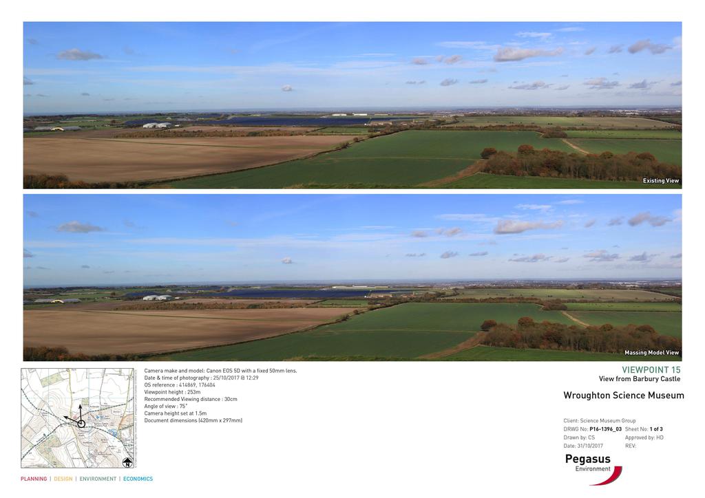
76 Appendix5- MasingModelPhotomontages

77 Appendi x5ma s s i ngmodel Phot omont a ges

78

79 pegasuspg.co.uk Pegasus Group First Floor South Wing Equinox North Great Park Road Almondsbury Bristol BS32 4QL E Bristol@pegasuspg.co.uk T PLANNING DESIGN ENVIRONMENT ECONOMICS COPYRIGHT The contents of this document must not be copied or reproduced in whole or in part without the written consent of Pegasus Group. Crown copyright. All rights reserved, Licence number
Statutory and Non-Statutory Designated Sites and Ecology
 Statutory and Non-Statutory Designated Sites and Ecology The National Planning Policy Framework considers the conservation and enhancement of the natural environment in chapter 11 paragraphs 109-119, where
7. The Landscape. 7.1 Introduction. Environmental Impact Statement (EIS) Scoping Report
 Scoping Report") 7. The Landscape 7.1 Introduction The purpose of this section of the EIS Scoping Report is to describe the scope of work and methods to be applied in the identification and assessment of landscape and
7. The Landscape 7.1 Introduction The purpose of this section of the EIS Scoping Report is to describe the scope of work and methods to be applied in the identification and assessment of landscape and
Tables of Criteria and Matrices for Landscape Assessment (LSCA & LVIA)
") Carly Tinkler CMLI Environmental, Landscape and Colour Consultancy 46 Jamaica Road, Malvern, Worcestershire WR14 1TU Tel +44 (0)7711 538854 carlytinkler@hotmail.co.uk Tables of Criteria and Matrices for
Carly Tinkler CMLI Environmental, Landscape and Colour Consultancy 46 Jamaica Road, Malvern, Worcestershire WR14 1TU Tel +44 (0)7711 538854 carlytinkler@hotmail.co.uk Tables of Criteria and Matrices for
North York Moors National Park Authority Planning Committee
 Item 8 North York Moors National Park Authority Planning Committee 12 December 2013 Consultation from Redcar and Cleveland Borough Council on proposed Wind Farm at Bank Field Guisborough 1. Purpose of
Settlement Boundaries Methodology North Northumberland Coast Neighbourhood Plan (August 2016)
") Introduction This background paper sets out a methodology for the definition of settlement boundaries in the North Northumberland Coast Neighbourhood Plan. The neighbourhood plan is planning positively
Introduction This background paper sets out a methodology for the definition of settlement boundaries in the North Northumberland Coast Neighbourhood Plan. The neighbourhood plan is planning positively
GUILDFORD BOROUGH GREEN BELT AND COUNTRYSIDE STUDY
 GUILDFORD BOROUGH GREEN BELT AND COUNTRYSIDE STUDY Volume II - Addendum On behalf of Guildford Borough Council PPG Ref : BNL.0287 April 2014 COPYRIGHT The conents of this document must not be copied or
Replacement Golf Course Facilities and Residential Development, Churston. Environmental Statement Non-Technical Summary
 Replacement Golf Course Facilities and Residential Development, Churston Environmental Statement Non-Technical Summary July 2011 Reproduced from the Ordnance Survey s map with the permission of the Controller
Viewpoint 1. Location: View from Murch Road on the north eastern boundary of Application Site. Viewing south / southwest.
 Application Site (eastern field) Former site of St. Cyres Lower School Murch Road 1 Location: View from Murch Road on the north eastern boundary of Application Site. Viewing south / southwest. Baseline
Genex Kidston Connection Project: Draf t Environmental Assessment Report Powerlink Queensland
 : Draf t Environmental Assessment Report Powerlink Queensland Chapter 14 \\autsv1fp001\projects\605x\60577456\6. Draft Docs\6.1 Reports\4. Compiled draft 17 September\Covers\Chapters\Ch 14.docx Rev ision
Guidance for Wind Turbine Development in the Dorset AONB
 Photo 1: Rew Manor Farm, West Dorset, chalk downland landscape (Planning application ref: 1/D/09/001280 1 ) Scale & siting: 12m to hub / 16m to blade tip. A well sited small scale turbine, grouped with
Salhouse Parish Council, 11 th November Response to Planning Application
 Salhouse Parish Council, 11 th November 2013 Response to Planning Application 20131408 Summary Salhouse Parish Council (SPC) has received via Broadland District Council a Planning Application for a 5MWp
Guidance for Wind Turbine Development in the Dorset Area of Outstanding Natural Beauty
 DRAFT January 2012 Guidance for Wind Turbine Development in the Dorset Area of Outstanding Natural Beauty Photo 1: Rew Manor Farm, West Dorset, chalk downland landscape (Planning application ref: 1/D/09/001280
Lower Sensitivity. VS Classification Level 2: Hills, Lower Plateau & Scarp Slopes (74%)/ Lowland Valleys (17%) / Exposed Upland/Plateau (7%)
/ Lowland Valleys (17%) / Exposed Upland/Plateau (7%)") S06 Coedwig Gwydyr Reproduced from the Ordnance Survey map with the permission of Ordnance Survey on behalf of the Controller of Her Majesty s Stationery Office, Crown copyright Licence No. 100023387 Location
S06 Coedwig Gwydyr Reproduced from the Ordnance Survey map with the permission of Ordnance Survey on behalf of the Controller of Her Majesty s Stationery Office, Crown copyright Licence No. 100023387 Location
an Inspector appointed by the Secretary of State for Communities and Local Government
 Appeal Decision Site visit made on 6 November 2017 by Rachel Walmsley BSc MSc MA MRTPI an Inspector appointed by the Secretary of State for Communities and Local Government Decision date: 19 th January
S08 Dyffryn Y Ddwyryd
 S08 Dyffryn Y Ddwyryd Reproduced from the Ordnance Survey map with the permission of Ordnance Survey on behalf of the Controller of Her Majesty s Stationery Office, Crown copyright Licence No. 100023387
orld Heritage Site W
 World Heritage Site Stonehenge Historic England Avebury Henge and Stone Circle Historic England The Great Wall of China The Pyramids of Giza, Egypt Stonehenge Mike Goddard Stonehenge and Avebury WHS Vision
Warwickshire County Council. Upper and Lower Brailes. Landscape Study
 Warwickshire County Council Upper and Lower Brailes Landscape Study Produced by WCC Landscape Architects March 2016 Landscape Assessment of Potential Development Sites within the parish of Brailes 1.0
9 Archaeology & Cultural Heritage
 High Clachaig Wind Farm Scoping Report Page 56 9 Archaeology & Cultural Heritage 9.1 Introduction Cultural heritage in this context means the above- and below-ground archaeological resources, built heritage,
Lower Sensitivity. VS Classification Level 2: Exposed Upland/Plateau
 S02 Y Carneddau Reproduced from the Ordnance Survey map with the permission of Ordnance Survey on behalf of the Controller of Her Majesty s Stationery Office, Crown copyright Licence No. 100023387 Location
Change of use and development of land to form The Stour Valley Visitor Centre at Horkesley Park.
 Sue Jackson Principal Planning Officer Colchester Borough Council PO Box 889 Rowan House 33 Sheepen Road Colchester CO3 3WG By email only 2 Aug 2012 Dear Ms Jackson, 120965 Change of use and development
Lower Sensitivity. VS Classification Level 2: Exposed Upland/Plateau
 S04 Moel Hebog Reproduced from the Ordnance Survey map with the permission of Ordnance Survey on behalf of the Controller of Her Majesty s Stationery Office, Crown copyright Licence No. 100023387 Location
BREEDON NORTHERN LIMITED
 Non Technical Summary CONTENTS 1 INTRODUCTION... 1 2 SITE DESCRIPTION... 1 3 DESCRIPTION OF THE DEVELOPMENT... 6 4 NEED FOR THE DEVELOPMENT... 8 5 KEY ISSUES CONSIDERED IN THE ENVIRONMENTAL IMPACT ASSESSMENT...
- - - Key Characteristics
 S23 Dyffryn Dysynni Reproduced from the Ordnance Survey map with the permission of Ordnance Survey on behalf of the Controller of Her Majesty s Stationery Office, Crown copyright Licence No. 100023387
Rolling Wooded Pasture Lulworth Wooded Pasture Rempstone Wooded Pasture
 Landscape type: Character areas: Rolling Wooded Pasture Lulworth Wooded Pasture Rempstone Wooded Pasture The rolling wooded pasture landscape type is found around the margins of the Dorset Heaths. Although
National Character Area 70 Melbourne Parklands
 Summary The are a landscape of rolling farmland, parkland and woodland on the northern flanks of the ridge between Burton upon Trent and Swadlincote. The land slopes down to the River Trent, which borders
Oxford Green Belt Study. Summary of Final Report Prepared by LUC October 2015
 Oxford Green Belt Study Summary of Final Report Prepared by LUC October 2015 Project Title: Oxford Green Belt Study Client: Oxfordshire County Council Version Date Version Details Prepared by Checked by
Public Consultation. Land at Monks Farm, North Grove. Welcome
 Welcome Welcome to our public exhibition for development on Land at Monks Farm, orth Grove. Gallagher Estates and Gleeson Strategic Land are preparing an outline planning application for new homes, open
3. Neighbourhood Plans and Strategic Environmental Assessment
 1. Introduction This report sets out a draft Screening Determination for the Preston Parish Council s Neighbourhood Plan and has been prepared by rth Hertfordshire District Council. The purpose of the
STATEMENT OF OBJECTION TO THE PROPOSED DEVELOPMENT OF LAND AT CHURCH CLIFF DRIVE FILEY
 STATEMENT OF OBJECTION TO THE PROPOSED DEVELOPMENT OF LAND AT CHURCH CLIFF DRIVE FILEY You will be aware that Scarborough borough council have adopted a new local plan that includes land at Church Cliff
Summary Note on Landscape and Visual Impact and Mitigation
 East Anglia TWO Offshore Windfarm Appendix 4.4 Summary Note on Landscape and Visual Impact and Mitigation Preliminary Environmental Information Volume 3 Document Reference EA2-DEVWF-ENV-REP-IBR- 000799_004
Wind energy development in the South Pennines landscape
 Wind energy development in the South Pennines landscape Programme for today Background Policy context South Pennines landscape Impacts of wind energy development The South Pennines Wind Energy Landscape
Environmental and Landscape Mapping
 Environmental and Landscape Mapping In support of the Calveley Neighbourhood Plan November 2016 Project Name and Number: Calveley Neighbourhood Plan 16-025 Document Name and Revision: Environmental and
To secure a Green Belt around Cambridge whose boundaries are clearly defined and which will endure for the plan period and beyond.
 4. GREEN BELT OBJECTIVES GB/a GB/b GB/c GB/d To secure a Green Belt around Cambridge whose boundaries are clearly defined and which will endure for the plan period and beyond. To maintain the purposes
BARRATT HOMES September 2017 LAND OFF ENGINE ROAD NAILSEA LANDSCAPE AND VISUAL IMPACT ASSESSMENT
 0 CONTENTS PAGE 1.0 INTRODUCTION 2 2.0 DESCRIPTION OF DEVELOPMENT & LANDSCAPE STRATEGY 4 3.0 BASELINE SURVEY AND ASSESSMENT 5 4.0 ASSESSMENT OF LANDSCAPE EFFECTS 11 5.0 ASSESSMENT OF VISUAL EFFECTS 17
The analysis of key visual characteristics and attributes that contribute to variations in the
 15.0 CHIGWELL/CHIGWELL ROW 15.1 Overview 15.1.1 Chigwell and Chigwell Row settlements are situated in the south of Epping Forest District, to the south of Abridge and southwest of Stapleford Abbotts. Both
ENVIRONMENTAL AND LANDSCAPE MAPPING
 APPENDIX IV : Environmental and Landscape Mapping ENVIRONMENTAL AND LANDSCAPE MAPPING Calveley Neighbourhood Plan November 2016 ENVIRONMENTAL AND LANDSCAPE MAPPING Calveley Neighbourhood Plan Calveley
LANDSCAPE AND VISUAL IMPACT ASSESSMENT
 TANGIER HOUSE TANGIER PARK WOOTTON ST. LAWRENCE RG23 8PH Regeneration & Restoration of Outbuildings LANDSCAPE AND VISUAL IMPACT ASSESSMENT Prepared by: ACLA Ltd For: Mr & Mrs T O'Donohoe Ref: ACLA/BEO
DUNSFOLD NEIGHBOURHOOD PLAN Site Selection Policies
 DUNSFOLD NEIGHBOURHOOD PLAN Site Selection Policies The criteria for assessing sites for future housing and business development in Dunsfold are set out below. (Development criteria, covering what it is
LANDSCAPE AND VISUAL ASSESSMENT
 Hertfordshire County Council LAND AT BALDOCK SITE 3 LANDSCAPE AND VISUAL ASSESSMENT JULY 2008 Jon Etchells Consulting Barn A, Dixies High Street Ashwell Herts SG7 5NT 01462 744662 HERTFORDSHIRE COUNTY
A payment of 1080 is due in this instance, for a meeting and follow up written response, and will be made by card over the phone.
 JPPC ref: AG/6002 18 th September 2014 Planning Services Vale of White Horse District Council Benson Lane Crowmarsh Gifford Wallingford OX10 8ED Dear Sir/Madam REQUEST FOR PRE-APPLICATION ADVICE RE: RESIDENTIAL
Lower Sensitivity. VS Classification Level 2: Exposed Upland/Plateau
 S05 Y Moelwynion Reproduced from the Ordnance Survey map with the permission of Ordnance Survey on behalf of the Controller of Her Majesty s Stationery Office, Crown copyright Licence No. 100023387 Location
Planning and Sustainability Statement
 Land adjacent to Manor Farm, Catterick Village Pallett Hill Sand and Gravel Co Ltd Proposed 10 new dwellings, (6 No market dwellings and 4 No affordable dwellings) with access, associated car parking and
Development in the setting of the Cotswolds AONB
 COTSWOLDS CONSERVATION BOARD POSITION STATEMENT Development in the setting of the Cotswolds AONB.1. Introduction Areas of Outstanding Natural Beauty (AONBs) are designated by the Government for the purpose
Grantham Southern Quadrant Link Road Environmental Statement
 Grantham Southern Quadrant Link Road Environmental Statement Non Technical Summary Introduction Lincolnshire County Council (LCC) is submitting a planning application for the proposed implementation of
Rochford District Council Allocations Development Plan Document: Discussion and Consultation Document Sustainability Appraisal
 Option SWH1 Balanced Communities Option SWH1 1 To ensure the delivery of high quality sustainable communities where people want to live and work Will it ensure the phasing of infrastructure, including
Schedule of Planning Applications Committee Date: 23 May Reference: 06/17/0726/F Parish: Hemsby Officer: Mr J Beck Expiry Date:
 Schedule of Planning Applications Committee Date: 23 May 2018 Reference: 06/17/0726/F Parish: Hemsby Officer: Mr J Beck Expiry Date: 22-05-2018 Applicant: Proposal: Site: Mr Gillett Change of use to the
LONGDEN VILLAGE DEVELOPMENT STATEMENT
 LONGDEN VILLAGE DEVELOPMENT STATEMENT 2017-2027 1 Longden Development Statement 2017-2027 15/01/18 1. Background 1.1 Longden Village Longden village is a very rural and traditional community first mentioned
2014/0590 Reg Date 26/06/2014 Chobham
 2014/0590 Reg Date 26/06/2014 Chobham LOCATION: PROPOSAL: TYPE: APPLICANT: OFFICER: ASCOT PARK POLO CLUB, WESTCROFT PARK FARM, WINDLESHAM ROAD, CHOBHAM, WOKING, GU24 8SN Erection of a two storey detached
Cotswolds AONB Landscape Strategy and Guidelines. June 2016
 Cotswolds AONB Landscape Strategy and Guidelines June 2016 Cotswolds AONB Landscape Strategy and Guidelines Introduction The evolution of the landscape of the Cotswolds AONB is a result of the interaction
Toddington Central Bedfordshire Stage 3 Green Belt Study December 2017
 Toddington Central Bedfordshire Stage 3 Green Belt Study December 2017 Site: ALP086 - Middle Lakes, Toddington Site size (ha): 2.83 Site: ALP086 - Middle Lakes, Toddington Site size (ha): 2.83 Site description
Lower Sensitivity. VS Classification Level 2: Exposed Upland/Plateau (86%)/ Upland Valleys (10%)
/ Upland Valleys (10%)") S09 Y Mignient Reproduced from the Ordnance Survey map with the permission of Ordnance Survey on behalf of the Controller of Her Majesty s Stationery Office, Crown copyright Licence No. 100023387 Location
S09 Y Mignient Reproduced from the Ordnance Survey map with the permission of Ordnance Survey on behalf of the Controller of Her Majesty s Stationery Office, Crown copyright Licence No. 100023387 Location
Definition of Cumulative Landscape and Visual Effects
 SECTION 5: GUIDANCE FOR ASSESSING CUMULATIVE LANDSCAPE AND VISUAL EFFECTS 5.1 Although this landscape sensitivity and capacity study has identified that parts of the National Park may be able to accommodate
Landscape Guidelines. Landscape type: Valley Pasture Character areas: Frome Valley Pasture Stour Valley Pasture. Landscape change
 Landscape type: Valley Pasture Character areas: Frome Valley Pasture Stour Valley Pasture The valley pasture landscape type is found along the lower reaches of the Stour and Frome, formed from alluvial
Parish of Repton NEIGHBOURHOOD DEVELOPMENT PLAN
 Parish of Repton NEIGHBOURHOOD DEVELOPMENT PLAN BASIC CONDITIONS STATEMENT December 2018 CEF 4 Legal Requirements This statement has been produced by the NDP Working Group on behalf of Repton Parish Council
NON TECHNICAL SUMMARY
 CONTENTS Introduction...1 Site Setting and Description...3 Proposed Development...3 Proposed Time Extension...4 Proposed Lateral Extension...4 Improvement of the main access road (Downs Lane)...4 Restoration
ROCHFORD LOCAL DEVELOPMENT FRAMEWORK: Sustainability Appraisal/ Strategic Environmental Assessment. Rochford Core Strategy Preferred Options Document
 ROCHFORD LOCAL DEVELOPMENT FRAMEWORK: Sustainability Appraisal/ Strategic Environmental Assessment Non Technical Summary Rochford Core Strategy Preferred Options Document October 2008 SUSTAINABILITY APPRAISAL
INTRODUCTION. Land south of Bishopswood Lane, Tadley
 0 INTRODUCTION THE SITE Introduction Gladman Developments Ltd. has successfully invested in communities throughout the UK over the past 0 years, developing high quality and sustainable residential, commercial
Site ref: AS06 Site Name or Address: Murreys Court, Agates Lane
 Site ref: AS06 Site Name or Address: Murreys Court, Agates Lane Proposed Land Use: Total Site Area (Ha): Housing 1.85 Ha Description: It is understood that the owner has no plans to dispose of the site
Garden Bridge Planning Application
 Planning Application Additional Verified photomontages and assessment September 2014 Contents Page 1 Visual assessment 2 1.1 Introduction 2 1.2 Baseline 2 1.3 Potential effects and good environmental
SPG 1. * the northern and western sections which are open fields used for pasture and grazing;
 SPG 1 1.0 INTRODUCTION This development brief is based on the allocation of the Priors Hall site for employment and countryside recreational purposes in the Corby Borough Local Plan. The brief is intended
Neighbourhood Planning Site Assessment Pro-forma and Guide Version 2
 Neighbourhood Planning Site Assessment Pro-forma and Guide Version 2 September 2014 Site HNP 006 Land East of Stanbridge Road and North of Lower Road 1. Background information Site location and use Site
LandscapeCollective. Dorothy House, Winsley. Landscape and Visual Appraisal. On behalf of Dorothy House Hospice Care.
 Project Ref: LC/00043 Project Number: 00043A Authored by: Stuart Hocking Reviewed by: Stephen Wadsworth Date: August 2016 Document version P:\Landscape Collective\Admin\Templates\LC Report Template Jan
NON-TECHNICAL SUMMARY
 NON-TECHNICAL SUMMARY THE HIDE, BISHOP AUCKLAND PROPOSED ECO CHALET DEVELOPMENT NON-TECHNICAL SUMMARY 1 Introduction 1.1.1 This non-technical summary for the (ES) prepared in relation to the proposed eco-chalet
Site Assessment Technical Document Appendix A: Glossary
 Central Bedfordshire Council www.centralbedfordshire.gov.uk Site Assessment Technical Document Appendix A: Glossary July 2017 1.1.11-1 - ii Appendix A: Glossary Term Agricultural Land Classification AONB
TOPIC PAPER 2: Links to other sustainability tools
 TOPIC PAPER 2: INTRODUCTION 1.1 Landscape Character Assessment can inform a range of other sustainability tools and methodologies. Equally these other tools may assist in reaching decisions concerning
CHAPTER 18 - Strategy Area: Dundry and River Valleys
 This south-eastern part of the Community Forest is a complex area with a wide variety of different landscapes close together, including the Chew Valley, the southern part of the Avon Valley and the eastern
Barvills Solar Farm Environmental Statement Non-Technical Summary
 Barvills Solar Farm Environmental Statement Non-Technical Summary 13 March 2015 Produced for Prepared by St John s House Queen Street, Manchester M2 5JB Contents Contents... 2 1 Introduction... 3 1.1 Development
Cranbrook EXPANSION ENVIRONMENTAL STATEMENT: NON-TECHNICAL SUMMARY PRODUCED BY DAVID LOCK ASSOCIATES
 Cranbrook EXPANSION ENVIRONMENTAL STATEMENT: NON-TECHNICAL SUMMARY PRODUCED BY DECEMBER 2014 CRANBROOK EXPANSION AREAS ENVIRONMENTAL STATEMENT NON TECHNICAL SUMMARY Submitted in support of Outline Planning
Route Alignment Options Summary Report
 Brechfa Forest Connection Project February 2014 Summary report 1. RSK Environment Ltd (RSK) was commissioned by Western Power Distribution (WPD) to provide environmental consultancy support services for
East Harptree Landscape & Character Assessment
 East Harptree Landscape & Character Assessment Produced by East Harptree Parish Council in consultation with local residents September 2014 Contents The Parish of East Harptree: Objective Introduction
PANSHANGER QUARRY, Hertfordshire
 PANSHANGER QUARRY, Hertfordshire Proposed enhanced restoration of Phases F & H Briefing Note 1 March 2015 INERT (INACTIVE) RESTORATION MATERIALS, CONTROLS AND OPERATIONS 1 Introduction This briefing note
Sustainability Statement. Whitby Business Park Area Action Plan
 Sustainability Statement Whitby Business Park Area Action Plan November 2014 Contents Page 1. Introduction 1 2. Scoping 3 3. Sustainability Appraisal of Options 6 4. Assessment of Draft Area Action Plan
List of Policies. SESPlan. None applicable. Consolidated Scottish Borders Local Plan 2011: POLICY G1 - QUALITY STANDARDS FOR NEW DEVELOPMENT
 List of Policies Local Review Reference: 15/00021/RREF Planning Application Reference: 15/00616/FUL Development Proposal: Installation of 16no solar photovoltaic (PV) panels to roof Location: Raebank,
S18 Mynyddoedd Yr Aran
 S18 Mynyddoedd Yr Aran Reproduced from the Ordnance Survey map with the permission of Ordnance Survey on behalf of the Controller of Her Majesty s Stationery Office, Crown copyright Licence No. 100023387
Ashtead Neighbourhood Forum Site Assessment AS03 Lime Tree Lodge, Farm Lane. Site address: Lime Tree Lodge, Farm Lane. Proposed Land Use:
 Site ref: AS03 Site address: Lime Tree Lodge, Farm Lane Proposed Land Use: Total Site Area (Ha): Housing 1.25ha Description The site is located off Farm Lane at the junction with Park Lane. To the north
Introduction. Grounds of Objection
 Planning application ref. number 18/04496/APP Planning application to Aylesbury Vale District Council for the erection of 17 dwellings and associated works to the South of Hogshaw Road Granborough. Granborough
A303 Stonehenge. Amesbury to Berwick Down Scheme Assessment Report Appendix D CSR and Policy Assessment. Volume 6
 A0 Stonehenge Amesbury to Berwick Down Scheme Assessment Report Appendix D CSR and Policy Assessment Volume 6 September 2017 Appendix D Client Scheme Requirements (CSRs) and Policy Assessment D.1 CSR Assessment
Chapter 7: Landscape and Visual Impact Assessment
 Chapter 7: Landscape and Visual Impact Assessment Landscape Character and Visual Impact Assessment 7. Landscape Character and Visual Impact Assessment... 2 7.1 Methodology... 2 7.2 Assessment Findings...
NON-TECHNICAL SUMMARY
 Proposed Sand and Gravel Extraction and Associated Processing Operations with Restoration to a Mixture of Agriculture and Nature Conservation including Areas of Shallow Water at Hedgeley, Northumberland
BUILDING ONE SCIENCE MUSEUM GROUP AT WROUGHTON
 SCIENCE MUSEUM GROUP AT WROUGHTON PREPARED BY PEGASUS GROUP SCIENCE MUSEUM GROUP NOVEMBER 2017 P16-1396 NOVEMBER 2017 CV P16-1396 PRE-APPLICATION PLANNING STATEMENT THE SCIENCE MUSEUM GROUP AT WROUGHTON
Plumpton Neighbourhood Development Plan Revised Pre Submission Document - Regulation 14 Consultation
 REPRESENTATIONS... Plumpton Parish Council Plumpton Neighbourhood Development Plan Revised Pre Submission Document - Regulation 14 Consultation Representations submitted on behalf of: Cala Homes (South
Landscape considerations in Forests & Woodlands. Jill Bullen, Senior Landscape Specialist
 Landscape considerations in Forests & Woodlands Jill Bullen, Senior Landscape Specialist UK Forestry Standard (UKFS) Sustainable forest management Landscape sub-section (S6.4, page 96) Standards and requirements
2A District-wide Policies
 2A Introduction This Chapter contains policies which are relevant to subdivision, use and development activities occurring across all zones and areas of the District. The policies in this Chapter implement
WELCOME. Land North of STEVENAGE. We would like to thank you for attending our public exhibition today.
 WELCOME We would like to thank you for attending our public exhibition today. The purpose of this event is to share our proposals and hear your thoughts on our ideas. Members of the project team are on
LANDSCAPE AND VISUAL ASSESSMENT
 Hertfordshire County Council LAND AT BALDOCK SITE 2 LANDSCAPE AND VISUAL ASSESSMENT JULY 2008 Jon Etchells Consulting Barn A, Dixies High Street Ashwell Herts SG7 5NT 01462 744662 HERTFORDSHIRE COUNTY
Project Title: Deephams Sewage Works Upgrade. Figure Title: Viewpoint 8. For Information Only. Figure 13.4
 Project Title: Deephams Sewage Works Upgrade Figure Title: Viewpoint 8 For Information Only Figure 13.4 June 2014 13.9 Visual Impact Assessment 13.9.1 Likely visual effects are assessed for significance
LANDSCAPE CHARACTER ASSESSMENT
 THE COUNTY DURHAM LANDSCAPE CHARACTER ASSESSMENT FOREWORD The landscape of County Durham is one of great contrast and diversity. From the North Pennines in the west to the Durham Coast in the east it contains
UTT/17/2075/FUL - (BERDEN) (Referred to Committee by Councillor Janice Loughlin. Reason: In the Public Interest)
 (Referred to Committee by Councillor Janice Loughlin. Reason: In the Public Interest)") UTT/17/2075/FUL - (BERDEN) (Referred to Committee by Councillor Janice Loughlin. Reason: In the Public Interest) PROPOSAL: LOCATION: APPLICANT: Amendments to the design of a scheme for a 49.99MW battery
UTT/17/2075/FUL - (BERDEN) (Referred to Committee by Councillor Janice Loughlin. Reason: In the Public Interest) PROPOSAL: LOCATION: APPLICANT: Amendments to the design of a scheme for a 49.99MW battery
Ref: A073350/SM/sm Date: 13 September 2013
 Ref: A073350/SM/sm Date: 13 September 2013 Ian Parkinson Development Control Team Leader Planning Portsmouth City Council Civic Offices Guildhall Square Portsmouth PO1 2AY Dear Ian LIGHT & GLEAVE VILLA
Planning and Regulatory Committee 20 May Applicant Local Councillor Purpose of Report
 Planning and Regulatory Committee 20 May 2014 7. APPLICATION FOR PLANNING PERMISSION FOR THE CARRYING-OUT OF DEVELOPMENT PURSUANT TO PLANNING PERMISSION REFERENCE NUMBER 603451 DATED 28 FEBRUARY 2007 WITHOUT
Request for a Scoping Opinion by Provectus. Proposed Surface Mining of Coal on Land west off the A61, Hill Top Farm, Clay Cross, Derbyshire
 Request for a Scoping Opinion by Provectus Proposed Surface Mining of Coal on Land west off the A61, Hill Top Farm, Clay Cross, Derbyshire January 2012 Contents 1 Introduction & Background... 1 2 Site
Section Three, Appendix 16C Medium Density Housing, Design Assessment Criteria (Residential 8A zone)
") APPENDIX 16C MEDIUM DENSITY HOUSING, DESIGN ASSESSMENT CRITERIA (RESIDENTIAL 8A ZONE) PURPOSE OF APPENDIX 16C (RESIDENTIAL 8A ZONE) In the Residential 8A Zone the following are defined as restricted discretionary
APPENDIX 16C MEDIUM DENSITY HOUSING, DESIGN ASSESSMENT CRITERIA (RESIDENTIAL 8A ZONE) PURPOSE OF APPENDIX 16C (RESIDENTIAL 8A ZONE) In the Residential 8A Zone the following are defined as restricted discretionary
Longbridge Town Centre Phase 2 Planning Application
 Longbridge Town Centre Phase 2 Planning Application Non-Technical Summary of the Environmental Statement December 2013 Introduction A full application for Planning Permission has been submitted to Birmingham
LANDSCAPE AND VISUAL IMPACT ASSESSMENT
 HARE STREET ROAD BUNTINGFORD LANDSCAPE AND VISUAL IMPACT ASSESSMENT Prepared by ACD Chartered Landscape Architects for Written By: SJD Checked By: JS Date: Document File Ref: TWNT18550lvia Revision: A-
South Whitehaven, Cumbria EIA
 South Whitehaven, Cumbria EIA Environmental Statement - Non Technical Summary June 2013 in association with 1. Introduction Story Homes is applying to Copeland Borough Council (CBC) for a new residential
tributary farmland tributary farmland
 NORFOLK O R F O L K COAST C O A SAONB T A O NIntegrated B I n t elandscape g r a t e d L Guidance a n d s c a p e G u i d a n c e 1 Integrated landscape character MAP 23a - Landscape Character Type - Tributary
Item No: 4 Reference: B/16/00635/FUL. Parish: BENTLEY Ward Member: Cllrs Stephen William and John Hinton
 Item No: 4 Reference: B/16/00635/FUL Parish: BENTLEY Ward Member: Cllrs Stephen William and John Hinton Location: Proposal: Applicant: Bentley Plants Ltd, Bergholt Road, Bentley, IPSWICH IP9 2DQ Change
PLANNING COMMITTEE DATE: 07/09/2015 REPORT OF THE SENIOR MANAGER PLANNING AND ENVIRONMENT SERVICE CAERNARFON. Number: 4
 Number: 4 Application Number: C15/0034/37/LL Date Registered: 21/05/2015 Application Type: Full - Planning Community: Llanaelhaearn Ward: Llanaelhaearn Proposal: Location: Summary of the Recommendation:
Neighbourhood Planning Local Green Spaces
 Neighbourhood Planning Local Green Spaces Introduction... 2 1. Why green space is important... 4 2. Neighbourhood plans and green space... 6 3. Evidence... 8 Statutory designations... 9 Green space audit...
Great Easton Neighbourhood Plan Statement of Basic Conditions
 Great Easton Neighbourhood Plan 2017-2031 Statement of Basic Conditions OCTOBER 2016 GREAT EASTON PARISH COUNCIL Contents 1.0 Introduction....Page 2 2.0 Summary of Submission Documents and Supporting Evidence..