City of Lafayette Staff Report
|
|
|
- Veronica Hall
- 5 years ago
- Views:
Transcription
1 City of Lafayette Staff Report For: By: Planning Commission Megan Canales, Planning Technician Meeting Date: April 6, 2015 Subject: Deadline: HDP15-14 RSR Development Company (Owners) R-10 Zoning: Request for: 1) a Phase I Hillside Development Permit for siting and massing determination 2) Design review approval, and 3) a Grading Permit to construct a new 4,226 3,341 sq. ft. two-story single-family residence with a maximum height of , requiring grading of 750 CY (385 CY cut / 365 CY fill) 388 CY (194 CY cut, 194 CY fill) on an undeveloped parcel within the Hillside Overlay District, located at 4 Dollis Park Road, APN May 5, 2015 (with PSA extension) EXECUTIVE SUMMARY This staff report provides summarizes the modifications made to the project since the prior Planning Commission Meeting. The proposed building design is not under evaluation at this time. Staff recommends that the Planning Commission adopt Resolution No approving the project. SUMMARY OF REQUEST Requested Approvals: 1. Hillside Development Permit (HDP): Phase I (Siting and massing) 2. Design Review Permit for the structures to exceed 17 ft. in height 3. Grading Permit for grading over 50 cubic yards Review Process: The Planning Commission will take final action on this application for siting and massing of the proposed residence. Once the house site and mass are approved by the Planning Commission, the applicant can submit full design plans for a Phase II HDP for review by the Design Review Commission. Scope of work: The Phase I application includes a new residence that is 3,341 sq. ft. (including garage) with a maximum height of Trigger Yes No Trigger Yes No Within a protected ridgeline setback? Within 100-ft. of a ridgeline setback? In the Hillside Overlay District? Over 17-ft. in height to ridge? SFR Development > 6,000 sq.ft.? Creek Setback required? Page 1 of 5 Grading > 50 cubic yards? DR required as condition of approval? In a commercial or MFR zone? Variance requested? Tree Permit Requested? Redevelopment Project Area
 Medium Density Single-Family Residential (Up to 6 dwelling units per acre) Single-Family Residential District- 10 (R-10) Steady upslope")
 None; Zone X SURROUNDING LAND USES Immediately Adjacent Zoning North Single-Family Residence (One-Story) R-10 South Dollis Park Road R-10 East Single-Family Residence (Two-Story) R-10 West")
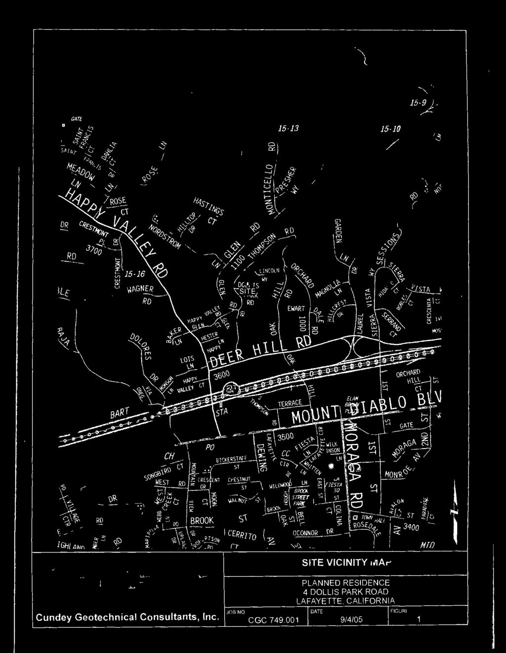
2 Planning Commission HDP15-14 Reddy Staff Report April 6, 2015 LOCATION & SITE CONDITIONS Looking north Location: General Plan: Zoning: Topography: Lot Size: Creek / Flood Zone: Looking west Dollis Park Road, off of North Thompson Road (location map attached) Medium Density Single-Family Residential (Up to 6 dwelling units per acre) Single-Family Residential District- 10 (R-10) Steady upslope toward the north 12,155-square feet (0.28 acres) None; Zone X SURROUNDING LAND USES Immediately Adjacent Zoning North Single-Family Residence (One-Story) R-10 South Dollis Park Road R-10 East Single-Family Residence (Two-Story) R-10 West Single-Family Residence (Two-Story) R-10 ENVIRONMENTAL REVIEW Staff evaluated the project in accordance with the California Environmental Quality Act ( CEQA ) and determined the project is categorically exempt under Section 15303, because the project entails the construction of a single-family residence in a residential zone that is already served by public services and is consistent with the General Plan. PUBLIC NOTICE & COMMENTS Property owners within 300 of the subject property were mailed a notice of public hearing, and the immediate area was posted at least ten days prior to the initial scheduled public hearing. Since the prior public hearing, staff has received two public comments, attached, as follows: Teresa Levine, 3 Dollis Park Road Pamela Gilchrist Halloran, 5 Dollis Park Road Page 2 of 5
3 Planning Commission HDP15-14 Reddy Staff Report April 6, 2015 REFERRAL AGENCIES COMMENTS The project plans were referred to the Central Contra Costa Sanitary District ( CCCSD ); City Engineer; City Landscape Consultant; Contra Costa County Building Inspection Department ( CCCBID ); and Contra Costa County Fire Protection District ( CCCFPD ). At the time the staff report was prepared, the City received comments from CCCSD, CCCBID, CCCFPD, and the City Engineer. Since the prior Commission meeting staff has received comments from the CCCFPD and the City Engineer, summarized below. Contra Costa County Fire Protection District, February 21, 2015 Provide an adequate and reliable water supply for fire protection Provide a fire hydrant at the property Submit improvement plans to the CCCFPD The home shall be protected with fire sprinklers No action is needed from the applicant at this time. City Engineer, February 5, 2015 The conceptual drainage plan is feasible for the proposed project Basins would be for roof or hardscape runoff only, not landscaped areas No action is needed from the applicant at this time. The note about basins can be addressed when a fully designed drainage plan is analyzed in Phase II of the project. PROJECT HISTORY On January 20, 2015, the Planning Commission considered the subject application and continued the matter to allow the applicant to make modifications. The Planning Commission provided the following comments: Comment The proposed residence is built setback to setback and occupies a large area of the site. Consider decreasing the proposed footprint. Manage the mass and scale of the proposed residence. Consider stepping the design with the hillside so that it responds better to the topography on the site. Applicant Response / Staff Comments The applicant reduced the width of the building footprint making it narrower (east to west). As seen on Sheet A1, the residence is now 6-6 further away from the neighbor to the west (at 51-7 compared to the 45-1 prior). In addition to reducing the width of the proposed residence, the applicant reduced the mass and scale of the residence in a number of ways: Lowered the finished floor elevation by 1-0 Increased upper-story step backs (setback the secondstory from the first-story by 10-0, as opposed to having the second-story align directly above the firststory), as seen on Sheet A3 Reduced the proposed square footage by 324 SF The proposed residence now follows the contours of the hillside and steps up with the hillside to a greater degree than the prior proposal, as seen on Sheet A3. Being more responsive to the topography, the proposed residence is able to use less retaining walls, have a reduced scale, and have a Page 3 of 5
4 Planning Commission HDP15-14 Reddy Staff Report April 6, 2015 Establish a strategy for how to handle drainage for the project. Explore alternatives of ways to access the site. The applicant developed a conceptual drainage plan, Sheet C1. The City Engineer indicated that it is a feasible approach to drainage for the proposed project. A more detailed drainage design will be reviewed during Phase II of the project. In response to the Commission, the applicant has provided a driveway study consisting of two options (Option A and Option B), attached. Option A is as designed in the project. Both options utilize pervious pavers and therefore do not have impervious surface implications. Option A has a less extreme slope and as such will require less grading than Option B. Staff finds that the applicant has effectively reduced the proposed mass and perceived scale of the residence from Dollis Park Road. The applicant reduced both the proposed square footage and the proposed height. The applicant also lowered the finished floor elevation which will help to reduce the overall scale. In addition, the proposed residence is more responsive to the topography (stepping up with the hillside) which further reduces the scale and creates larger upper-story step-backs. The upperstory step backs move the mass away from the street and further minimize the scale. Staff recognizes that during Phase II of the project, the Design Review Commission can work with the applicant to ensure that the design (including design details on the residence, articulation to the building envelope, colors and materials, landscaping, and drainage) is consistent with the Residential Design Guidelines, General Plan, and Findings. STAFF RECOMMENDATION Staff finds that the project applicant has modified the project in response to the Planning Commission s comments at the prior meeting. Staff recommends that the Planning Commission adopt Resolution No to approve HDP15-14, which includes the following actions: 1. Find the project categorically exempt under Section from the California Environmental Quality Act. 2. Approve the Phase I Hillside Development Permit for siting and massing. ATTACHMENTS 1. Aerial Maps & Photos 2. Applicant s response to findings 3. Applicant s transmittal letter with changes to plans 4. Applicant s Driveway Study 5. Geotechnical Reports (available online only) a. Updated by Peter & Ross July 1, 2014 b. Prepared by Cundey Geotechnical Associates September 8, Public Agency Referral Comments a. CCCFPD b. City Engineer c. CCCBID d. CCCSD 7. Public Comments a. Teresa Levine, 3 Dollis Park Road Page 4 of 5
5 Planning Commission HDP15-14 Reddy Staff Report April 6, 2015 b. Pamela Gilchrist Halloran, 5 Dollis Park Road 8. Planning Commission Resolution No [DRAFT] 9. Conditions of Approval [DRAFT] 10. Project Plans, received March 2, 2015 Page 5 of 5

6 4 Dollis Park Road APN CityGIS 300 ft

7 4 Dollis Park Road APN CityGIS 200 ft

8 4 Dollis Park Road APN CityGIS 100 ft

9 4 Dollis Park Road APN CityGIS 40 ft
10 RSR DEVELOPMENT COMPANY Builders / Designers Established 1988 HPD15-14 RESPONSE TO FINDINGS Project Description General The proposal is for a new 3,116 SF residence the design and layout of which comply with all city requirements and guidelines The previous SFR built in 1930 s was removed leaving behind a barren lot completely devoid of any esthetics or landscaping and is a blight upon the neighborhood in every aspect. The new structure will comply with current building, energy and green codes to provide extensive upgrades, energy conservation, structural stability and overall neighborhood appeal and significantly enhance surrounding property values. HILLSIDE DEVELOPMENT: A. Explain how the development is consistent with the applicable goals and policies of the General Plan and is in conformance with applicable zoning regulations. The development meets the spirit and letter of the goals and policies of the general plan. B. Explain how the development will preserve open space and physical features, including rock outcroppings and other prominent geological features, streams, streambeds, ponds, drainage swales, native vegetation, native riparian vegetation, animal habitats and other natural features. The development will preserve open space and physical features. It leaves the lot wide open for the neighbors enjoyment of views. There are no streams, creeks or natural habitat that will be obscured. C. Explain how structures in the Hillside Overlay District will, to the extent feasible, be located away from prominent locations such as ridgelines, hilltops, knolls and open slopes; The constraints provide no choice for the home site. The lot/hill is not part of a ridgeline or hilltop. D. Explain how the development, including site design and the location and massing of all structures and improvements will, to the extent feasible: 1. Minimize the loss of privacy to surrounding residents and not unduly impact, restrict or block significant views; The home site and development proposal is perfectly situated to have little if any impact on privacy or views for surrounding residents. 2. Not have a significant visual impact when viewed from lower elevations from public places, using the viewing evaluation map as a guide to establish locations from which views are considered; and
11 The proposal will not create any silhouettes from lower elevations, as it is back-dropped by the rest of the hill above, and by much larger, higher structures and existing vegetation along the uphill. 3. Not interfere with a ridgeline trail corridor or compromise the open space or scenic character of the corridor. n/a E. Within 100 feet of a restricted ridgeline area, or when a exception to a ridgeline setback has been granted, explain how the development will result in each structure being substantially concealed by terrain or vegetation when viewed from lower elevations from public places, using the Viewing Evaluation Map as a guide to establish locations from which views are considered. n/a F. Explain how development grading will be minimized to limit scarring and cutting of hillsides especially for long roads or driveways, preserve existing geologic features, topographic conditions and existing vegetation, reduce short and long term erosion, slides and flooding, and abate visual impacts. Because the massing is driven by the contours, it minimizes cut and fill. The massing will harmonize with the shape of the hill. There will be low water/native plantings proposed, and therefore minimal irrigation will be needed in the area. G. Explain how the development provides adequate emergency vehicle access, including turn around space, to the building site and surrounding on site undeveloped or isolated areas. No special emergency access is required. H. Explain how each structure and proposed landscaping complies with the City s Residential Design Guidelines. The massing of the house has been carefully designed with the intent of Lafayette s Residential Design Guidelines. It responds to the contours of the property and provides proportions that are so important to Lafayette s traditional hillside building stock. Landscaping will be used to enhance privacy and views of neighbors. I. Explain how the new or replacement vegetation for the development is native to the surrounding area in areas abutting open space and natural areas, such as oak woodland, chaparral, grassland and riparian areas, and conforms to the following policies, pursuant to Section : New or replacement vegetation in an area abutting open space and natural areas, such as oak woodland, chaparral, grassland and riparian areas, excluding planting for erosion control or land stabilization, shall be native to the surrounding area. The goal of the planting should be a seamless blending with the natural vegetation. The reviewing authority may grant an exception to this requirement for a small garden area near the home provided it is not visible from public places and contains no non native trees or shrubs over six feet in height, or large green expanses. There will be low water/native plantings proposed per section , and therefore minimal irrigation will be needed in the area. J. Explain how the development will not create a nuisance, hazard or enforcement problem within the neighborhood or the city, nor require the city to provide an unusual or disproportionate level of public services. No special nuisance is foreseeable and extensive engineering will insure stability and safety of the neighborhood.
12 DESIGN REVIEW Specific Findings Required for Design Review. 1. Every provision of this chapter is complied with; 2. The approval of the plan is in the best interest of the public health, safety and general welfare; The proposed new residence is in keeping with all current City design requirements, standards, and regulations. The previous SFR built in 1930 s was removed leaving behind a barren lot completely devoid of any esthetics or landscaping and is a blight upon the neighborhood in every aspect. The new structure will comply with current building, energy and green codes to provide extensive upgrades to energy conservation, structural stability and overall neighborhood appeal and significantly enhance surrounding property values. 3. General site considerations, including site layout, open space and topography, orientation and location of buildings, vehicular access, circulation and parking, setbacks, height, walls, fences, public safety and similar elements have been designed to provide a desirable environment for the development; The proposed new residence will be sited within all required Setbacks, following the natural contours of the property and slightly forward of where the previous structure was located, leaving existing rear planting area and the hillside virtually undisturbed. Parking circulation is a huge problem in the area at present, multiple additional off street parking spaces are proposed; over and above what is required and where existing street parking is currently non-existent. 4. General architectural considerations, including the character, scale and quality of the design, the architectural relationship with the site and other buildings, building materials, colors, screening of exterior appurtenances, exterior lighting and signing and similar elements have been incorporated in order to ensure the compatibility of this development with its design concept and the character of adjacent buildings; and The proposed new residence will greatly enhance the existing neighborhood and bring it to keeping with the character, scale and quality of existing adjacent Homes, actually becoming a prominent and unique design compliment. 5. General landscape considerations, including the location, type, size, color, texture and coverage of plant materials, provisions for irrigation, maintenance and protection of landscaped areas and similar elements have been considered to ensure visual relief, to complement buildings and structures and to provide an attractive environment for the enjoyment of the public. The proposed new residence will be planted with low-water, native plantings to bring the site to current neighborhood standards and conditions as opposed to the current barren lot completely devoid of any esthetics or landscaping.
13 Findings for Structures Over 17 ft. in Height 1. The structure substantially complies with the city's residential design guidelines; 2. The structure is so designed that it will appear compatible with the scale and style of the existing neighborhood and will not significantly detract from the established character of the neighborhood; The proposed new residence will greatly enhance the existing neighborhood and bring it to keeping with the character, scale and quality of existing adjacent Homes, actually becoming a prominent and unique design compliment. 3. The structure is so designed that it does not appear too tall or massive in relation to surrounding structures or topography when viewed from off site; 4. The structure is so designed that it does not unreasonably reduce the privacy or views of adjacent properties. The proposed new residence will be two stories (massing contoured naturally) within the maximum height of 35 feet.. It will be set with the backdrop of the hillside and foliage as viewed from the street. Any views from adjacent properties are minimal due to the steep hillside to the left and existing trees on the right. GRADING 1. The grading will not endanger the stability of the site or adjacent property or pose a significant ground movement hazard to an adjacent property. See Soils Report attached ; extensive engineering will insure stability and safety of the neighborhood 2. The grading will not significantly increase erosion or flooding affecting the site or other property and will not cause impacts to riparian habitats, stream channel capacity, or water quality that cannot be substantially mitigated. There are no riparian features to be impacted. 3. The grading, when completed, will result in a building site that is visually compatible with the surrounding land. 4. The grading is sensitive to the existing landforms, topography, and natural features on the site. Because the massing is driven by the contours, it minimizes cut and fill. The massing will harmonize with the shape of the hill. 5. The design of the project preserves existing trees on the site and trees on adjoining property to the extent possible. 6. Arborist recommendations for retained trees, if any, are incorporated into the grading plan. No trees are proposed to be removed for the project, the design of the project protects the one existing tree which shall be additionally protected during construction.
14 Letter of Transmittal Date:3/03/15 To: ATTN: MEGAN CANALES LAFAYETTE PLANNING DEPARTMENT (BY HAND and ) From: Ravi Reddy/ RSR Development Co. 3000F Danville Blvd #268 Alamo, CA Tel: RE: HDP15-14 REDDY 4 DOLLIS PARK Road, Lafayette, CA APN: Dear Megan: Please see attached Full Size and Reduced Size revisions. I have also ed a PDF of the same to you. We confirm previously providing copies of the Conceptual Drainage/Grading plan prepared by our Civil Engineers after the consultative meeting with City Engineer Tony Coe (also attached at page A6). Architectural Revisions Summary: We followed all three staff recommendations: 1. The whole building is dropped by 1-0 (eg. garage floor el. Is now vs ) 2. The building foot print is now much narrower and pulled away from the west setback line. At the closest point, we are now 6.5 feet further away from 3 Dollis Park (51-7 versus previous 45-1 see page A1). The second story mass above the garage has been shifted rearward 10 feet to very significantly reduce the massing as viewed from the street (see A3). Massing of the upper floor is now broken up and shifted so as to follow the natural grade of the hill, retaining walls at rear of the house eliminated and upper floor shifted rearwards and downwards to reduce overall height and scale of the structure. The open deck/roof above the garage has been scaled down and roof lines redesigned to further break up the massing and reduce scale. Outdoor Space is indicated and Details removed from Site Plan A2. 3. Building size has been reduced by 324 sf from 3135 sf to 2811 sf (not including garage) see page A7.. / 2
15 Page 2 continued: Drainage: Following our meeting with City Engineer Tony Coe on Tuesday, our Civil Engineer s have produced a conceptual Drainage/Grading plan so as to come up with a design that follows the current storm control guidelines. To summarize the basic design features that we will be implementing the following (see attached conceptual Civil Engineer s plan also): 1. We propose to use carefully designed swales & storm-water retention/detention basin areas to control and guide run-off around the new residence and to prevent sheet-flowing onto the road areas. 2. We will also NOT be using any impervious paving and in fact the pavers that we do use will be fully permeable 'honey-comb' style; as recommended in the County Storm-Water guidebook. 3. We also note that the total impervious square footage of our proposal is only 2152 SF and the project is actually exempt from the Water Quality Control Board requirements and doesn't technically require a Storm-water Control Plan. Nevertheless we are still going to implement the mitigation measures as noted above. Thank again for your help! Best regards, Ravi Reddy Tel: rreddy@rsrdevelopment.com
16 HDP15-14: 4 Dollis Park Road, Lafayette CA Driveway Study Option A Option B Configuration Side Entry (West) Front Entry (South) Impervious Driveway SF 0 Square Feet 0 Square Feet Average Driveway Slope 12% 20% Applicant's Preference? YES NO
17 4 Dollis Park Road, Lafayette, CA Driveway Study Option A Side Entry
18 4 Dollis Park Road, Lafayette, CA Driveway Study Option B Front Entry
19 Peters & Ross Geotechnical & Geoenvironmental Consultants July 1, 2014 Project No Mr. Ravi Reddy RSR Development Company 3000F Danville Blvd., #268 Alamo, CA Geotechnical Update Reddy Residence, 4 Dollis Park Road, Lafayette, California Dear Mr. Reddy: In accordance with your request, Peters & Ross reviewed Cundey Geotechnical Consultants, Inc. (CGC) report dated September 8, 2005, Project No Mr. Reddy requested that Peters & Ross provide this update letter and assume the role of geotechnical engineer of record. It is our opinion that from a geotechnical perspective, the conclusions and recommendations provided by CGC, with the exception of the seismic design parameters, apply to the planned residence. Seismic Concerns In accordance with Section 1613 of the 2013 CBC, Peters & Ross classifies the site as a C Site Class with a latitude of degrees and a longitude of degrees. The CBC parameters presented in the following table should be used for seismic design. PERIOD (sec) SPECTRAL RESPONSE Ss, Sl SITE COEFFICIENT Fa, Fv (SITE CLASS C) MAXIMUM SPECTRAL RESPONSE Sms, Sml DESIGN SPECTRAL RESPONSE SDs, SDl The site is not within an Alquist-Priolo Earthquake Fault Zone, and therefore the risk of fault rupture at the site is remote. No loose, clean sands were observed in the test boring. Therefore, the risk of significant foundation settlement due to liquefaction or densification during a large magnitude earthquake is low. Plan Review and Construction Observation and Testing Services Peters & Ross should review project plans, to check that the geotechnical engineering recommendations contained in this letter are properly incorporated. We should provide geotechnical observation services on an as-needed basis during construction, to check that geotechnical aspects of the work are completed in accordance with the plans. These services 114 Hopeco Road, Pleasant Hill, CA Phone: (925) Fax: (925) PetersRoss@aol.com

20 Reddy Residence July 1, 2014 Project No Page 2 of 2 should include observing foundation excavation and providing consultation to the contractor regarding any geotechnical concerns that arise during construction. Peters & Ross cannot accept responsibility for geotechnical aspects of construction that are not observed by its staff. Peters & Ross will make every reasonable effort to accommodate the contractor s work schedule during construction, so that necessary observations can be performed in a timely manner to avoid construction delays. However, since our field services are often required on several projects concurrently, we request that 48 hours advance notice be given for site visits, in order to minimize scheduling conflicts. Limitations Peters & Ross services consist of professional opinions and recommendations that are made in accordance with generally accepted geotechnical engineering principles and practices. The opinions and recommendations presented in this update letter are based on a review of the work performed by CGC, and our site meeting with Mr. Reddy. This warranty is in lieu of all other warranties either expressed or implied. If you have any questions, please call. Sincerely, Peter K. Mundy, P.E., G.E. Geotechnical Engineer Hopeco Road, Pleasant Hill, CA Phone: (925) Fax: (925) PetersRoss@aol.com


21


22


23

24

25


26


27


28


29

30

31


32


33


34

35


36


37

38

39


40


41


42


43


44


45

46
47

48
49 Canales, Megan Subject: FW: FW: HDP15-14, 4 Dollis Park Road- Meeting with Tony Coe today re Stormwater Control From: Coe, Tony Sent: Thursday, February 5, :02 AM To: Canales, Megan Subject: RE: FW: HDP15-14, 4 Dollis Park Road- Meeting with Tony Coe today re Stormwater Control Ok, but basins would be for roof or hardscape runoff only, not landscaped areas. TC From: Canales, Megan Sent: Thursday, February 5, :45 AM To: Coe, Tony Subject: RE: FW: HDP15-14, 4 Dollis Park Road- Meeting with Tony Coe today re Stormwater Control Hi Tony, Attached is 4 Dollis Park Road s conceptual drainage plan. Please let me know your comments. Thank you in advance, Megan From: Coe, Tony Sent: Tuesday, February 3, :14 PM To: Canales, Megan Subject: RE: FW: HDP15-14, 4 Dollis Park Road- Meeting with Tony Coe today re Stormwater Control Megan: We discussed the concept, and I asked for a conceptual layout to memorialize the intent before the PC meeting. Understanding that it s phase 1, a detailed design is not needed, but a layout would be helpful to align understanding and expectations. TC From: Canales, Megan Sent: Tuesday, February 3, :01 PM To: Coe, Tony Subject: FW: FW: HDP15-14, 4 Dollis Park Road- Meeting with Tony Coe today re Stormwater Control Hi Tony, Just wanted to confirm the e mail below. This project is a 2 phase project (siting and massing with the Planning Commission and design details with the Design Review Commission). We are on phase I and the Planning Commission wanted to know the drainage approach and if it would work on the site. The Commission recognizes that the site is very tricky and want to ensure that their approach to drainage seems feasible given the new residence proposed. Will you need to see an actual drainage plan to speak to the drainage or can you comment on the approach and let me know if it seems feasible to handle the drainage in the ways they describe? Thanks, Megan 1
50 From: Ravi Reddy Sent: Tuesday, February 3, :15 PM To: Canales, Megan Subject: RE: FW: HDP15-14, 4 Dollis Park Road- Meeting with Tony Coe today re Stormwater Control Hi Megan, my civil engineer and I met with Tony Coe this morning to discuss the design of the project drainage & stormwater control. We discussed different design elements and settled on using carefully designed swales & retention/detention areas to control and guide run-off around the new residence and to prevent sheetflowing onto the road areas. We will also NOT be using any impervious paving and in fact the pavers that we do use will be fully permeable 'honey-comb' style. I also note that the total impervious square footage of our proposal is only 2152 SF and the project is actually exempt from the Water Quaility Control Board requirements and doesn't technically require a Stormwater Control Plan. Nevertheless we are still going to implement the mitigation measures as noted above. Best regards, Ravi Reddy, Principal R S R Development Company PLANNING --- DESIGN --- CONSTRUCTION Established 1988 Lic B Tel:
51 Canales, Megan From: Sent: To: Subject: Coe, Tony Tuesday, January 20, :59 PM Canales, Megan RE: Referral HDP15-14, 4 Dollis Park Road Megan: The public comment references on going creep in the area and the resulting structural damage to adjacent homes. The creep is acknowledged to some degree in the Cundey report, which also outlines some broad measures for countering creep in the design. If the Commission shares the stated public concern, it would not be unreasonable to require a peer review of both the geotechnical report and the construction drawings to ensure reasonable compliance with prevailing standards. Separately, the City Attorney is drafting a special indemnification agreement that is applicable to projects proposed on sites with elevated risks. I would strongly recommend this project be conditioned to execute that special agreement. Related, the geotechnical issues will make it even more difficult, if not impossible, for this project to comply with current stormwater guidelines using standard, conventional means. It will be critical that this project eliminates all outdoor hardscape and explore creative site design strategies such as a living roof design that minimizes/eliminates runoff. Short of that, the development footprint may need to shrink in a substantial way, so as to be below triggers for even the Small Project thresholds. At that point, the project would still need to undertake site design measures to mitigate to the maximum extent practicable. Tony From: Canales, Megan Sent: Tuesday, January 20, :20 PM To: Coe, Tony Subject: RE: Referral HDP15-14, 4 Dollis Park Road Importance: High Hi Tony, The Commission is reviewing this project tonight. They plan on asking for a drainage plan so that can be reviewed further by you, seeing as this will be a tricky site and based on your comment below. There was a public comment, attached, in regards to concern with the stability of the hillside. A geotechnical report, attached, was done for the project. I got a call from the Chair of the Planning Commission just now, and he asked that you comment on the geotechnical side of the project. Is the report sufficient or do you have further comments/concerns? Since the project is being heard tonight, I would like to have an answer in hand if you have time to take a look. If not, I can follow up after the hearing with them. Let me know if you have any questions. Thank you in advance, Megan From: Coe, Tony Sent: Wednesday, January 14, :23 AM To: Canales, Megan Subject: RE: Referral HDP15-14, 4 Dollis Park Road Megan: 1
52 It will be a challenge for this project to handle stormwater runoff in a way that is consistent with current guidelines to not affect downstream systems. There is little, if any, formal drainage facility in Dollis Park Road, a private road, to handle runoff. The project parcel consists mostly of steep grades not conducive to the typical stormwater management measures. The proposed pervious driveway is only effective in the upper part of the driveway near the garage, since the lower portion is indicated to be at 25% grade. Currently there is little information shown on the drawings to indicate what the drainage design intent might me. This project will need to get creative in finding ways to mitigate its runoff impact. Tony From: Canales, Megan Sent: Monday, January 12, :41 PM To: Canales, Megan Subject: Referral HDP15-14, 4 Dollis Park Road Dear Referral Agencies, Please find a digital referral packet for 4 Dollis Park Road attached to this e mail. Thank you in advance for your comments. Take Care, Megan Canales Planning Technician City of Lafayette Direct: (925) Main: (925) How are we doing? Please take a moment to fill out our customer satisfaction form here! 2
53 Canales, Megan Subject: FW: Referral HDP15-14, 4 Dollis Park Road From: Coe, Tony Sent: Wednesday, January 14, :23 AM To: Canales, Megan Subject: RE: Referral HDP15-14, 4 Dollis Park Road Megan: It will be a challenge for this project to handle stormwater runoff in a way that is consistent with current guidelines to not affect downstream systems. There is little, if any, formal drainage facility in Dollis Park Road, a private road, to handle runoff. The project parcel consists mostly of steep grades not conducive to the typical stormwater management measures. The proposed pervious driveway is only effective in the upper part of the driveway near the garage, since the lower portion is indicated to be at 25% grade. Currently there is little information shown on the drawings to indicate what the drainage design intent might me. This project will need to get creative in finding ways to mitigate its runoff impact. Tony 1
54 Canales, Megan Subject: FW: Referral HDP15-14, 4 Dollis Park Road From: Thom Huggett [mailto:thom.huggett@dcd.cccounty.us] Sent: Tuesday, January 13, :40 AM To: Canales, Megan Subject: RE: Referral HDP15-14, 4 Dollis Park Road Hi Megan, I have no comments at this time. Thom Huggett, PE, SE Principal Structural Engineer Lamorinda Building Inspection Office 3685 Mt. Diablo Blvd., Suite 120 Lafayette, CA (925) (925) fax thom.huggett@dcd.cccounty.us 1
55 Canales, Megan From: Sent: To: Subject: Follow Up Flag: Flag Status: Russ Leavitt Tuesday, January 13, :45 AM Canales, Megan HDP15-14; replacement residence, 4 Dollis Park Road, Lafayette Follow up Flagged The property has received Central Contra Costa Sanitary District (CCCSD) sanitary sewer service and the replacement residence would not be expected to produce an unmanageable added capacity demand on the wastewater system, nor interfere with existing facilities. The applicant must submit full-size building plans for CCCSD to review and pay all appropriate fees, including for capping and abandoning or inspecting the existing sewer lateral for reuse. For more information, the applicant should contact the CCCSD Permit Section at (925) Thanks! Russell B. Leavitt Engineering Assistant III Central Contra Costa Sanitary District (CCCSD) 5019 Imhoff Place Martinez, CA v (925) f (925) rleavitt@centralsan.org 1
56 Canales, Megan From: Sent: To: Subject: Follow Up Flag: Flag Status: Teresa Monday, February 2, :48 PM Canales, Megan; Letter Regarding 4 Dollis Park Road Follow up Completed February 2, 2015 Dear Commissioners: Re: Plans to build a new home on 4 Dollis Park Road. Please accept this as is a follow-up to a letter I sent regarding plans to build a home at 4 Dollis Park Road, directly adjacent to my home at 3 Dollis Park Road. I am out of town, but listened to the audio of the January 20th hearing on the City of Lafayette website. The main issue I wish to address, and clarify, is the matter of the road, which was discussed at the hearing. As you are aware, Dollis Park is a private road, and therefore it is the responsibility of the homeowners to maintain the surface. However, my concern is not so much for the condition of the road, although it is an issue, but for the stability of the slope that supports the road,.and the base of my home. As I mentioned in my previous letter, the late Paul Seidelman, of Seidelman and Associates, believed the slope would need to have a retaining wall built to prevent a slide caused by further stress. An inclinometer set in the slope, next to the road directly below my home,has measured movement, and the asphalt continues to crack and show signs of duress. The movement of the slope affects the condition of the pavement, but it also adds downward pressure to my home s foundation. It is my opinion, and I believe I have the consensus of all the neighbors, that Mr. Reddy should have his engineers do an assessment of the depth and nature of the movement on the slope, and, if necessary, to build an appropriate retaining wall to assure we are all protected, when he brings in heavy vehicles. I also agree that the issue of drainage is important, and perhaps a plan can be implemented that incorporates water overflow measures, while stabilizing the paved slope. I support Mr. Reddy s desire to build on the property, and respect the commissioner s abilities to ascertain the appropriate size and style of the house. My only concern regarding the home s design is that it blends with the fabric of the neighborhood, as my home is a large Mediterranean design, and the other homes are more of the original cottage style built in the early years of Lafayette s history. Sincerely, Thank-you for your kind consideration of this matter. Teresa Wilkes Levine 3 Dollis Park Road Lafayette, CA Teresa Levine creativerevolution@aol.com 1
57 Canales, Megan From: Sent: To: Cc: Subject: Follow Up Flag: Flag Status: Pamela Gilchrist Halloran Monday, February 2, :30 AM Canales, Megan Teresa Levine 4 Dollis Park Rd Follow up Completed Dear Megan My husband and I have owned the house at 5 Dollis Park Rd in Lafayette for 25 years. I am writing to give you our perspective regarding the proposed plans for 4 Dollis Park Rd. We are very interested in having a house built on that site and feel that it is a good thing. Originally there were 5 little vacation homes on that road, all in one family. #4 Dollis Park was torn down at least 15 years ago and since then it has been an empty lot. I ve met with Ravi Reddy a few times and feel satisfied that he will build a good house. We just have a few concerns. Our biggest concern is the road. The level of the road was raised when #4 was torn down and the prior owner of #3 and #4 changed the lot lines between those two properties. I think there should be some kind of retaining wall along the downhill side to prevent the failure of the road. Since we are at the end of the road, our home would be rendered inaccessible if the road were to fail. I also think particular care should be taken in regard to drainage. Ideally, I think, the water from #4 should travel down the road to North Thompson. Otherwise, it seems to me the water will seep under the road, undermining it and the hillside further. I am no expert, but improving the surface of the road, fixing the curb on the downhill side, installing a retaining wall and perhaps a creating swale to channel all the water down to the main street seem like important considerations, and I think it is reasonable to require of Mr Reddy. Finally, in regard to style, I ve always felt that the cottage feel is best on that road as that is what was the intent when these houses were all built back in the 30 s. The Denman family used to come over the hill to their little houses in the woods, before there was even a tunnel. (Ravi mentioned that the planners talked of vertical siding. I personally think horizontal siding is nicer or even shingles.) By the way, I am a local real estate agent/broker. Currently a rental, we do intend to live in 5 Dollis Park again, and we are very interested in the future value of our home. I think that by your taking particular care at this juncture that value will be preserved and enhanced. Thank you so much for taking particular caution with the plans for this property. I hope that you and Mr Reddy can come to a consensus so he can get building soon. While we want it to be right, we also really want him to be successful! Sincerely, Pamela and James Halloran 1
58 Pamela Gilchrist Halloran Broker associate Pacific Union and Christie s International Real Estate 201 Lafayette Circle, Suite 100, Lafayette, CA c f pamela@pamelahalloran.com License #
59 Planning Commission Resolution No A RESOLUTION OF THE PLANNING COMMISSION OF THE CITY OF LAFAYETTE APPROVING: HDP15-14 RSR Development Company (Owners) R-10 Zoning: Request for: 1) a Phase I Hillside Development Permit for siting and massing determination 2) Design review approval, and 3) a Grading Permit to construct a new 3,341 sq. ft. two-story single-family residence with a maximum height of 32-10, requiring grading of 388 CY (194 CY cut, 194 CY fill) on an undeveloped parcel within the Hillside Overlay District, located at 4 Dollis Park Road, APN Only establishment of a house site and mass are under consideration at this time. RECITALS A. On May 13, 2014, Ravi Reddy filed an application, requesting review and approval of HDP15-14 for a siting and massing determination for a new two-story single-family residence within the Hillside Overlay District, located on a vacant parcel on Dollis Park Road. B. On June 11, 2014 the application was deemed incomplete. C. On January 5, 2014 the application was deemed complete. D. On January 20, 2015 the Planning Commission conducted a public hearing where it received written and oral testimony, including a staff report. The Commission discussed the application and provided feedback to the applicant. The Commission asked that the applicant to reduce the mass and scale of the proposed residence, reduce the footprint of the proposed residence, design the residence to respond better to the topography, study the drainage on the site, and study the access to the residence. The Commission continued the matter to February 17, 2015 to allow the applicant to make modifications. E. On February 17, 2015, and March 2, 2015, the Planning Commission continued the matter, without discussion, to allow the applicant to have additional time to respond to the Commission s comments. F. On April 6, 2015, the Planning Commission conducted a public hearing where it received written and oral testimony, including a staff report. The Commission concluded that the applicant has substantially addressed its concerns and the Commission can support the siting and massing, with conditions. The Commission adopted Planning Commission Resolution No , approving HDP15-14, subject to conditions. FINDINGS NOW, THEREFORE, the Planning Commission of the City of Lafayette, California finds and determines as follows: 1. All the facts contained in the staff reports of January 20, 2015, and April 6, 2015 are hereby adopted as the Commission s own findings of fact and incorporated into this resolution by reference. 2. The required findings for the requested Phase I Hillside Development Permit approval per , 6-275, , and of the Lafayette Municipal Code have been evaluated by the Commission as follows: The project complies with the above findings in that the siting and massing strictly satisfy the Hillside Development Permit findings applicable for this phase as demonstrated below. Page 1 of 5
60 Planning Commission HDP15-14 Reddy Resolution April 6, Findings required for approval of a hillside development permit on an existing lot of record. The hearing authority may approve an application for a hillside development permit on an existing lot of record in the hillside overlay district only after making the following findings: (a) The development is consistent with the applicable goals and policies of the general plan and is in conformance with applicable zoning regulations; (b) The development will preserve open space and physical features, including rock outcroppings and other prominent geological features, streams, streambeds, ponds, drainage swales, native vegetation, native riparian vegetation, animal habitats and other natural features; (c) Structures in the hillside overlay district will, to the extent feasible, be located away from prominent locations such as ridgelines, hilltops, knolls and open slopes; (d) The development, including site design and the location and massing of all structures and improvements will, to the extent feasible: (1) Minimize the loss of privacy to surrounding residents and not unduly impact, restrict or block significant views; (2) Not have a significant visual impact when viewed from lower elevations from public places, using the viewing evaluation map as a guide to establish locations from which views are considered; and (3) Not interfere with a ridgeline trail corridor or compromise the open space or scenic character of the corridor. (e) Within 100 feet of a restricted ridgeline area, or when a exception to a ridgeline setback has been granted, the development will result in each structure being substantially concealed by terrain or vegetation when viewed from lower elevations from public places, using the viewing evaluation map as a guide to establish locations from which views are considered; (f) Development grading will be minimized to limit scarring and cutting of hillsides especially for long roads or driveways, preserve existing geologic features, topographic conditions and existing vegetation, reduce short and long-term erosion, slides and flooding, and abate visual impacts; (g) The development provides adequate emergency vehicle access, including turn-around space, to the building site and surrounding on-site undeveloped or isolated areas; (h) Each structure and proposed landscaping complies with the city s residential design guidelines; (i) The new or replacement vegetation for the development is native to the surrounding area in areas abutting open space and natural areas, such as oak woodland, chaparral, grassland and riparian areas, and conforms to the policies of Section ; and (j) The development will not create a nuisance, hazard or enforcement problem within the neighborhood or the city, nor require the city to provide an unusual or disproportionate level of public services. The Planning Commission finds that the project meets the required findings. They conclude that the project is consistent with the applicable General Plan goals and policies, R-10 Zoning District regulations, and the applicable Residential Design Guidelines. The project s compliance with the Residential Design Guidelines in terms of design, colors and materials, and proposed landscaping, and will be evaluated in the design phase (Phase II) of the project. Page 2 of 5
61 Planning Commission HDP15-14 Reddy Resolution April 6, 2015 The lot is highly constrained and due to setbacks, configuration of the site, and site topography there are limited building sites. The proposed residence is sited low on the site which also helps to reduce the scale and visibility. This siting also facilitates a shorter driveway which limits grading and scarring of the hillside. The proposed building site is consistent with the Guidelines, particularly in that it is sited to preserve trees, open space, and natural features on the property. In addition, the proposed residence is sited so that it steps with the hillside which further reduces the scale of the residence, off-site visibility, and protects the views of neighboring residences. The proposed development is not visible from any Viewing Evaluation sites due to existing vegetation, topography, and other structures. New landscape screening will be considered in Phase II of the project and will be required to be appropriate in size species and location for the hillside setting. The project has been reviewed by the Contra Costa County Fire Protection District, and there is no indication that the project does not provide adequate emergency access. There is no indication that the development will pose a hazard or enforcement issue for the neighborhood and is adequately served by existing infrastructure and utilities (A) Residential Design Review Findings (1) The approval of the plan is in the best interest of the public health, safety and general welfare; (2) General site considerations, including site layout, open space and topography, orientation and location of buildings, vehicular access, circulation and parking, setbacks, height, walls, fences, public safety and similar elements have been designed to provide a desirable environment for the development; (3) General architectural considerations, including the character, scale and quality of the design, the architectural relationship with the site and other buildings, building materials, colors, screening of exterior appurtenances, exterior lighting and signing and similar elements have been incorporated in order to ensure the compatibility of this development with its design concept and the character of adjacent buildings; and (4) General landscape considerations, including the location, type, size, color, texture and coverage of plant materials, provisions for irrigation, maintenance and protection of landscaped areas and similar elements have been considered to ensure visual relief, to complement buildings and structures and to provide an attractive environment for the enjoyment of the public. The Commission is able to make the aforementioned findings in regards to siting and massing of the project. Referral agencies have provided no comments indicating a health or safety risk and there is no evidence or indication that the health and safety of the public would be adversely affected by this project. The proposed siting and massing maintains the use of the property as a single-family residence, which is consistent with the R-10 zoning district. The project s compliance with the City s Residential Design Guidelines in terms of design, scale, style, colors and materials, and proposed landscaping, and will be evaluated in Phase II of the project. The site design is consistent with the Guidelines, particularly in that the siting responds appropriately to the property s site conditions and is designed to preserve trees and natural features on the property. In addition, the property slopes gradually up toward the north and the proposed residence steps up with the hillside. Page 3 of 5
City of Lafayette Staff Report
 City of Lafayette Staff Report For: By: Planning Commission Megan Canales, Planning Technician Meeting Date: January 20, 2015 Subject: Deadline: HDP15-14 RSR Development Company (Owners) R-10 Zoning: Request
City of Lafayette Study Session Staff Report Design Review Commission
 ++ City of Lafayette Study Session Staff Report Design Review Commission Meeting Date: January 08, 2018 Staff: Subject: Chris Juram, Planning Technician SS12-17 Miramar Homebuilders, R-20 Zoning: Request
City of Lafayette Study Session Staff Report Design Review Commission
 City of Lafayette Study Session Staff Report Design Review Commission Meeting Date: April 24, 2017 Staff: Payal Bhagat, Senior Planner Subject: HDP18-15 & HDP31-15 Ramesh Patel & Melcor Development (Owners),
City of Lafayette Staff Report
 City of Lafayette Staff Report For: By: Design Review Commission Greg Wolff, Senior Planner Meeting Date: April 27, 2015 Subject: SS03-15 Gundi & Peter Younger (Owners), R-40 Zoning: Request for a Study
PLANNED DEVELOPMENT (MASTER PLAN & UNIT PLAN)
") Central Permit Center 555 Santa Clara Street Vallejo CA 94590 Business License Building Fire Prevention Planning Public Works 707.648.4310 707.648.4374 707.648.4565 707.648.4326 707.651.7151 PLANNED DEVELOPMENT
Central Permit Center 555 Santa Clara Street Vallejo CA 94590 Business License Building Fire Prevention Planning Public Works 707.648.4310 707.648.4374 707.648.4565 707.648.4326 707.651.7151 PLANNED DEVELOPMENT
City of Lafayette Staff Report
 City of Lafayette Staff Report For: By: Design Review Commission Greg Wolff, Senior Planner Meeting Date: November 25, 2013 Subject: L03-11 O BRIEN LAND CO., LLC (APPLICANT), AMD FAMILY TRUST (OWNER),
COMPLIANCE CHECKLIST HILLSIDE RESIDENTIAL DESIGN GUIDELINES MANUAL
 COMPLIANCE CHECKLIST HILLSIDE RESIDENTIAL DESIGN GUIDELINES MANUAL The following checklist summarizes development guidelines and standards. See the appropriate section for a complete explanation of the
City of Lafayette Study Session Project Data
 City of Lafayette Study Session Project Data For: Design Review Commission By: Michael P. Cass, Senior Planner Date: August 24, 2015 Property Address: 954 Mountain View Drive APN: 243-070-011 Zoning District:
14825 Fruitvale Ave.
 REPORT TO THE PLANNING COMMISSION Meeting Date: August 26, 2015 Application: PDR14-0017 Location/APN: 14825 Fruitvale Ave. / 397-18-028 Applicant/Owner: Staff Planner: Sin Yong Michael Fossati 14825 Fruitvale
PLANNING COMMISSION AGENDA REPORT SEPTEMBER 1, 2016
 PLANNING COMMISSION AGENDA REPORT SEPTEMBER 1, 2016 TO: Members of the Planning Commission FROM: Michael Klein, Planner FILE NO.: 150000780 PROPOSAL: APPLICANT: RECOMMENDATION: A request for a Site Plan
Site Design (Table 2) Fact Sheet & Focus Questions:
 Fact Sheet & Focus Questions:") Site Design (Table 2) Fact Sheet & Focus Questions: BACKGROUND WHAT IS SITE DESIGN? Site design refers to the arrangement of buildings and open spaces on adjacent sites to maximize the shared benefits
Site Design (Table 2) Fact Sheet & Focus Questions: BACKGROUND WHAT IS SITE DESIGN? Site design refers to the arrangement of buildings and open spaces on adjacent sites to maximize the shared benefits
File No (Continued)
") (Continued) Request for: (1) a Site Plan Review; (2) a Variance (to build on a significant ridgeline); (3) an Oak Tree Permit (to encroach into the protected zone of 25 oak trees and for potential thinning
(Continued) Request for: (1) a Site Plan Review; (2) a Variance (to build on a significant ridgeline); (3) an Oak Tree Permit (to encroach into the protected zone of 25 oak trees and for potential thinning
City of Lafayette Staff Report
 City of Lafayette Staff Report For: By: Design Review Commission Sarah Allen, Associate Planner Meeting Date: May 23, 2016 Subject: Deadline: HDP04-16 Joe Egan (Owner) R-20 Zoning: Request for (1) a Hillside
Design Review Commission Report
 City of Beverly Hills Planning Division 455 N. Rexford Drive Beverly Hills, CA 90210 TEL. (310) 285-1141 FAX. (310) 858-5966 Design Review Commission Report Meeting Date: Thursday, March 2, 2017 Subject:
CITY OF LAGUNA BEACH COMMUNITY DEVELOPMENT DEPARTMENT STAFF REPORT DESIGN REVIEW BOARD IBOARD OF ADJUSTMENT Coast Highway APN
 CITY OF LAGUNA BEACH COMMUNITY DEVELOPMENT DEPARTMENT STAFF REPORT HEARING DATE: October 13,2011 TO: DESIGN REVIEW BOARD IBOARD OF ADJUSTMENT CASE: Variance 7717 Design Review 11-163 Coastal Development
Project phasing plan (if applicable) 12 copies of site plan
 12 copies of site plan") SITE PLAN REVIEW PERMIT APPLICATION City of Grand Haven, 11 N. Sixth Street, Grand Haven, MI 49417 Phone: (616) 847-3490 Fax: (616) 844-2051 Website: www.grandhaven.org 1. Project Information Address/location
SITE PLAN REVIEW PERMIT APPLICATION City of Grand Haven, 11 N. Sixth Street, Grand Haven, MI 49417 Phone: (616) 847-3490 Fax: (616) 844-2051 Website: www.grandhaven.org 1. Project Information Address/location
GENERAL PLAN CONSISTENCY ANALYSIS
 GENERAL PLAN CONSISTENCY ANALYSIS Prepared by Planning Staff 10/28/2013 APPLICABLE GOALS, POLICIES AND PROGRAMS FROM the LAND USE CHAPTER Goal LU-1 Policy LU-1.1 Policy LU-1.2 Goal LU-2 Protect the character
PLANNING COMMISSION AGENDA REPORT APRIL 7, 2016
 PLANNING COMMISSION AGENDA REPORT APRIL 7, 2016 TO: FROM: Members of the Planning Commission Talyn Mirzakhanian, Senior Planner FILE NO.: 160001710 PROPOSAL: APPLICANT: RECOMMENDATION: A request for a
RESIDENTIAL GUIDELINES CHECKLIST
 RESIDENTIAL GUIDELINES CHECKLIST The following checklist was created to provide you with an easy way to ensure that your project complies with the Residential Design Guidelines. RESIDENTIAL DESIGN GUIDELINES
Example Codes. City of Brentwood, Tennessee Brentwood Hillside Protection Overlay District Summary
 Example Codes City of Brentwood, Tennessee Brentwood Hillside Protection Overlay District Summary The City of Brentwood in July 2007 adopted a Hillside Protection (HP) Overlay District to address the problems
DECISION CRITICAL AREAS ALTERATION AND DETERMINATION OF NONSIGNIFICANCE (DNS)
") DECISION CRITICAL AREAS ALTERATION AND DETERMINATION OF NONSIGNIFICANCE (DNS) Development Services Department 17301 133rd Avenue NE Woodinville, WA 98072 425-489-2754 www.ci.woodinville.wa.us Project Name:
DECISION CRITICAL AREAS ALTERATION AND DETERMINATION OF NONSIGNIFICANCE (DNS) Development Services Department 17301 133rd Avenue NE Woodinville, WA 98072 425-489-2754 www.ci.woodinville.wa.us Project Name:
ORDINANCE NO WHEREAS, the City of Kalama has many areas of timberland and open areas inside its City limits adjacent to residential areas;
 ORDINANCE NO. 1342 AN ORDINANCE OF THE CITY OF KALAMA, WASHINGTON ADOPTING A NEW KALAMA MUNICIPAL CODE CHAPTER 17.20 ESTATE LOT FLOATING ZONE TO PROVIDE TRANSITIONAL ZONING OPTIONS FOR RESIDENTIAL DEVELOPMENT
Town of Windham. Planning Department 8 School Road Windham, ME voice fax
 Town of Windham Planning Department 8 School Road Windham, ME 04062 voice 207.864-5960 fax 207.892.1916 MEMO DATE: TO: Staff Review Committee FROM: Amanda Lessard, Planner Cc: Ellen Rathbone, St. Germain
At Your Disposal CUP Amendment, Lot 20, Village Service Commercial, at 128 Bastille Dr. (PLN17-208)
") MEMORANDUM Archuleta County Development Services Planning Department 1122 HWY 84 P. O. Box 1507 Pagosa Springs, Colorado 81147 970-264-1390 Fax 970-264-3338 TO: Archuleta County Planning Commission FROM:
MEMORANDUM Archuleta County Development Services Planning Department 1122 HWY 84 P. O. Box 1507 Pagosa Springs, Colorado 81147 970-264-1390 Fax 970-264-3338 TO: Archuleta County Planning Commission FROM:
Notice of Preparation of an Environmental Impact Report and Scoping Meeting for the Canyon Lane Roadway Improvements Development Project
 of an Environmental Impact Report and Scoping Meeting for the As the Lead Agency, the County of San Mateo (County) will prepare an Environmental Impact Report (EIR) for the (project), and would like your
THE CITY COUNCIL OF THE CITY OF SAN JUAN BAUTISTA DOES HEREBY ORDAIN AS FOLLOWS:
 ORDINANCE NO. 2016 01 AN ORDINANCE OF THE CITY OF SAN JUAN BAUTISTA AMENDING THE SAN JUAN BAUTISTA MUNICIPAL CODE TO ADD CHAPTER 11-08 HILLSIDE DEVELOPMENT REGULATIONS WHEREAS, the City Council has reviewed
The Maryland-National Capital Park and Planning Commission Prince George's County Planning Department Development Review Division
 The Maryland-National Capital Park and Planning Commission Prince George's County Planning Department Development Review Division 301-952-3530 Note: Staff reports can be accessed at www.mncppc.org/pgco/planning/plan.htm.
CITY OF CYPRESS 5275 Orange Avenue Cypress, California (714) DESIGN REVIEW COMMITTEE PERMIT PROCESS
 DESIGN REVIEW COMMITTEE PERMIT PROCESS") CITY OF CYPRESS 5275 Orange Avenue Cypress, California 90630 (714) 229-6720 DESIGN REVIEW COMMITTEE PERMIT PROCESS 1. Discuss project with Planning staff to determine zoning regulations, any unusual characteristics
CITY OF CYPRESS 5275 Orange Avenue Cypress, California 90630 (714) 229-6720 DESIGN REVIEW COMMITTEE PERMIT PROCESS 1. Discuss project with Planning staff to determine zoning regulations, any unusual characteristics
DESIGN REVIEW COMMITTEE AGENDA ITEM
 DESIGN REVIEW COMMITTEE AGENDA ITEM AGENDA DATE: OCTOBER 17, 2012 TO: Chair Woollett and Members of the Design Review Committee THRU: FROM: SUBJECT: Leslie Aranda Roseberry, Planning Manager Daniel Ryan,
Chapter 4 - Preparation of Stormwater Site Plans
 Chapter 4 - Preparation of Stormwater Site Plans The Stormwater Site Plan is the comprehensive report containing all of the technical information and analysis necessary for the City to evaluate a proposed
A. General Plan: Land Use, Growth Management and the Built Environment Element. d. Use visually unobtrusive building materials.
 Chapter 16 Hillside Protection 16.010 Purpose This chapter establishes the regulations for development and alteration of properties in hillside and ridgeline areas in order to preserve the essential scenic
ARTICLE IV: DEVELOPMENT STANDARDS 404 MASTER PLANNING
 IV 13 404 MASTER PLANNING Master Planning through the Site Analysis (Master Planning Site Analysis) or Planned Development (Master Planning Planned Development) is provided to encourage development which
RESOLUTION NO
 RESOLUTION NO. 2018- RESOLUTION OF THE PLANNING COMMISSION OF THE CITY OF BELMONT APPROVING A SINGLE-FAMILY DESIGN REVIEW AND TREE REMOVAL PERMIT FOR A VACANT LOT ON LOWER LOCK AVENUE (APN: 043-042-750,
COUNTY OF SANTA CRUZ MEMORANDUM. To: Don Bussey, Zoning Administrator From: Lawrence Kasparowitz, Project Planner
 1 - COUNTY OF SANTA CRUZ I MEMORANDUM Date: June 21,2006 To: Don Bussey, Zoning Administrator From: Lawrence Kasparowitz, Project Planner Re: 02-0432 Agenda Date: July 21, 2006 Agenda Item #: 0.1 Time:
Appendix I. Checklists
 Appendix I Checklists Town of Greenwich Drainage Manual Department of Public Works - Engineering Division Town Hall - 101 Field Point Road, Greenwich, CT 06836-2540 Phone 203-622-7767 - Fax 203-622-7747
STORMWATER MANAGEMENT CODES ANALYSIS RICHLAND COUNTY, SC SITE PLANNING ROUNDTABLE
 STORMWATER MANAGEMENT CODES ANALYSIS RICHLAND COUNTY, SC SITE PLANNING ROUNDTABLE Codes analyses for each subcommittee were completed to assist participants of the Richland County Site Planning Roundtable.
Design Review Application *Please call prior to submittal meeting to determine applicable fees*
 CITY OF EAGLE 660 E. Civic Lane, Eagle, ID 83616 Phone#: (208) 939-0227 Fax: (208) 938-3854 Design Review Application *Please call prior to submittal meeting to determine applicable fees* FILE NO.: CROSS
Infill Residential Design Guidelines
 Infill Residential Design Guidelines Adopted March 23, 2004 Amended September 10, 2013 City of Orange Community Development Department Planning Division Phone: (714) 744-7220 Fax: (714) 744-7222 www.cityoforange.org
Planning Commission Staff Report February 19, 2009
 Planning Commission Staff Report February 19, 2009 Project: Warda Warehouse File: EG-08-051 Request: Design Review Location: 9260 Bendel Place APNs: 134-0660-004 Planner: Gerald Park Property Owner/Applicant
DATE: PLANNING COMMISSION MEETING OF FEBRUARY 24, 2016
 DATE: PLANNING COMMISSION MEETING OF FEBRUARY 24, 2016 TO: FROM: SUBJECT: THE PLANNING COMMISSION LISA COSTA SANDERS, TOWN PLANNER REQUEST FOR A SPECIAL STRUCTURES PERMIT FOR A POOL IN THE SIDE YARD AND
Request for Decision. Recommendation. Presented: Monday, Jul 07, Report Date Friday, Jun 20, Type: Public Hearings
 Presented To: Planning Committee Request for Decision Application for rezoning in order to permit a place of worship on a vacant lot zoned for C1, Local Commercial uses, Cam Street, Sudbury Sitiri Investments
Zoning Ordinance Chapter 10
 CHAPTER 10 - WASHES SECTION 10.0 GENERAL: A. The purpose of this Ordinance is to establish standards for development in or near Major and Minor Washes as defined in Appendix A Glossary of Terms and Definitions
STORMWATER GREEN INFRASTRUCTURE AND PLANNING/ZONING BOARDS
 STORMWATER GREEN INFRASTRUCTURE AND PLANNING/ZONING BOARDS Source: Center for Watershed Protection, 2007 Southern Tier Central Regional Planning & Development Board Chemung County Stormwater Team OUTLINE
APPROVED WITH CONDITIONS
 Provo City Planning Commission Report of Action October 26, 2016 ITEM 10 Provo City Parks and Recreation Department requests a variance to the Sensitive Lands Ordinance to grade within a hillside of 30%
SECTION 1 CLEARING /GRADING PERMIT APPLICATION:
 PLEASE REFER TO THE CLEARING & GRADING PERMIT CHECKLIST BELOW FOR SUBMITTAL REQUIREMENTS. SECTION 1 CLEARING /GRADING PERMIT APPLICATION: PROJECT ADDRESS (Street, Suite #): Parcel(s) #: Total Site Area
LANDSCAPING. Design. Development of the site shall not unreasonably impair the ability of adjoining properties to utilize solar energy.
 Landscape design is an integral component of Site Planning and Building. The current pattern of walkways, driveways and landscape elements such as fences, hedges, and retaining walls in the neighborhood
Chapter 3 Site Planning and Low Impact Development
 CHAPTER 3 Site Planning and Low Impact Development Chapter 3 Site Planning and Low Impact Development 3.0 Introduction The City of Charleston requires that major residential, large commercial (>1 acre),
PLANNING COMMISSION AGENDA REPORT NOVEMBER 15, 2012
 PLANNING COMMISSION AGENDA REPORT NOVEMBER 15, 2012 TO: FROM: Members of the Planning Commission Michael Klein, Associate Planner FILE NO.: 120000890 PROPOSAL: APPLICANT: Request for an Administrative
CITY OF ZEELAND PLANNING COMMISSION
 APPLICATION FOR SITE PLAN REVIEW AND SPECIAL LAND USE Date City Official App. Filing Fee Rec'd ($350) NOTE TO APPLICANT: Please submit this application for Site Plan Review along with twenty (20) copies
Staff Report. Conditional Use PLANNING DIVISION COMMUNITY & ECONOMIC DEVELOPMENT. Salt Lake City Planning Commission
 Staff Report PLANNING DIVISION COMMUNITY & ECONOMIC DEVELOPMENT To: From: Salt Lake City Planning Commission Maryann Pickering, Principal Planner (801) 535-7660 Date: December 10, 2014 Re: Church of Scientology
City of Saratoga. Adoption date: Revision date(s):
:") City of Saratoga Adoption date: Revision date(s): February 19, 2014 In recognition of the city s unique character and the desire to protect the residential characteristics of its neighborhoods, the City
City of Saratoga Adoption date: Revision date(s): February 19, 2014 In recognition of the city s unique character and the desire to protect the residential characteristics of its neighborhoods, the City
Planning Commission Staff Report Project Plan Approval Hearing Date: June 14, 2017
 Planning Commission Staff Report Project Plan Approval Hearing Date: June 14, 2017 ITEM 3 Peter Matson requests Project Plan Approval for an 80-acre mixed-use plan that includes 220 residential units and
COMMUNITY DESIGN. GOAL: Create livable and attractive communities. Intent
 COMMUNITY DESIGN Intent An attractive, well-designed County will attract quality development, instill civic pride, improve the visual character of the community, and create a strong, positive image for
TOWN OF HILLSBOROUGH SAN MATEO COUNTY
 TOWN OF HILLSBOROUGH SAN MATEO COUNTY Planning Office 650/375-7422 Fax 650/375-7415 1600 Floribunda Avenue Hillsborough California 94010 Architecture and Design Review Board LANDSCAPING APPLICATION PACKET
Site Plan Review Residential Accessory Building
 COMMUNITY DEVELOPMENT DEPARTMENT Planning Division P.O. Box 490 333 Broadalbin Street SW Albany, OR 97321 Phone (541) 917-7550 Fax (541) 917-7598 www.cityofalbany.net Site Plan Review Residential Accessory
MAJOR SITE PLAN APPLICATION COVER SHEET
 MAJOR SITE PLAN APPLICATION COVER SHEET TOWN OF CLAYTON Planning Department 111 E. Second St., P.O. Box 879 Clayton, NC 27528 Phone: 919-553-5002 Fax: 919-553-1720 Name of Project: Date: Applicant Name:
SENSITIVE LANDS OVERLAY
 SENSITIVE LANDS OVERLAY Chapter 22 Sensitive Lands Overlay 22.1 PURPOSE 22.2 APPLICATION AND ANALYSIS REQUIREMENTS 22.3 SENSITIVE LAND REGULATIONS 22.4 ADMINISTRATIVE PROVISIONS 22.5 DESIGN STANDARDS 22.6
PRELIMINARY CONDITIONAL USE SUBMITTAL CHECKLIST REQUIREMENTS
 This checklist must accompany your submittal as the cover page. CONDITIONAL USE Application Submittal Checklist for PRELIMINARY AND FINAL APPROVAL Per Winter Park Land Development Code Sec. 58-90 PRELIMINARY
Highway Oriented Commercial Development Criteria
 7.6 HOC-1 Highway Oriented Commercial District A. Statement of Purpose The Highway Oriented Commercial District (HOC-1) is intended to provide for the development of high density retail and service businesses
Stormwater Technical Guide
 Stormwater Technical Guide Compliance with Stormwater Post-Construction Requirements in Santa Barbara County Dan Cloak, Principal Dan Cloak Environmental Consulting January 9, 2014 Introduce yourself Name
Major Subdivision Sketch Plan Checklist
 This checklist provides specific requirements that are apart of the Sketch process. The entire process is described by the Huntersville Subdivision Review Process which details all the submittal and resubmittal
ORDINANCE NO. City of Bellingham City Attorney 210 Lottie Street Bellingham, Washington INFILL HOUSING ORDINANCE Page 1
 ORDINANCE NO. AN ORDINANCE RELATING TO LAND USE PLANNING AND ZONING, CREATING A NEW BMC CHAPTER 20.28 INFILL HOUSING, AND NEW SUBSECTION BMC 20.12.030.E, GREEN FACTOR LANDSCAPING STANDARDS, AND AMENDING
DESIGN REVIEW COMMITTEE AGENDA ITEM
 DESIGN REVIEW COMMITTEE AGENDA ITEM AGENDA DATE: OCTOBER 3, 2012 TO: Chair Woollett and Members of the Design Review Committee THRU: FROM: SUBJECT: Leslie Aranda Roseberry, Planning Manager Daniel Ryan,
GENERAL INFORMATIONaaaaaaaaaaaaaaaaaaaaaaaaaaaaaaaa
 To: Planning and Zoning Commission From: City Staff Date: November 15, 2016 Re: Case #16026 Raymore Activity Center Site Plan GENERAL INFORMATIONaaaaaaaaaaaaaaaaaaaaaaaaaaaaaaaa Applicant/ Property Owner:
Advance Engineering & Surveying PLLC
 Advance Engineering & Surveying, PLLC Consulting in: Civil & Environmental Engineering Land Surveying Land Development 11 Herbert Drive Phone: (518) 698-3772 Latham, N.Y. 12110 Email:ncostape@gmail.com
City of Larkspur. Notice of Mitigated Negative Declaration for the 285
 Notice of Mitigated Negative Declaration for the 285 Magnolia Avenue Mixed-Use Project Date: December 2, 2013 Responsible Agency: Project Title: 285 Magnolia Avenue Mixed-Use Project Project Address: 285
CHAPTER 22 Rural Open Space Community Developments
 CHAPTER 22 Rural Open Space Community Developments Section 22.1 Description and Purpose The intent of this Chapter is to offer property owners an alternative to traditional zoning requirements for rural
Approved: CITY OF ARDEN HILLS, MINNESOTA PLANNING COMMISSION WEDNESDAY, AUGUST 5, :30 P.M. - ARDEN HILLS CITY HALL
 Approved: CITY OF ARDEN HILLS, MINNESOTA PLANNING COMMISSION WEDNESDAY, AUGUST 5, 2015 6:30 P.M. - ARDEN HILLS CITY HALL PLANNING CASES A. Planning Case 15-016; Final Planned Unit Development Arden Plaza;
STORMWATER UTILITY FREQUENTLY ASKED QUESTIONS
 STORMWATER UTILITY FREQUENTLY ASKED QUESTIONS What is Stormwater? Stormwater is water that falls to the ground during a precipitation event. When land is undeveloped or covered with vegetative surface,
PC RESOLUTION NO
 PC RESOLUTION NO. 14-01-14-02 TENTATIVE TRACT MAP fttm) 17441. REZONE {RZ) 13-003, ARCHITECTURAL CONTROL (AC) 13-003, TREE REMOVAL PERMIT (TRP) 13-052. GRADING PLAN MODIFICATION (GPM) 13-002. CONDITIONAL
PLANNING APPROVAL & PLANNED UNIT DEVELOPMENT Date: April 6, 2017
 PLANNING APPROVAL & PLANNED UNIT DEVELOPMENT Date: April 6, 2017 DEVELOPMENT NAME LOCATION Mobile Christian School 5900 Cottage Hill Road (North side of Cottage Hill Road, 230 ± West of Freemont Drive
Re: Application Type: Proposed Highlands Redevelopment Area Designation
 CHRIS CHRISTIE Governor KIM GUADAGNO Lt. Governor State of New Jersey Highlands Water Protection and Planning Council 100 North Road (Route 513) Chester, New Jersey 07930-2322 (908) 879-6737 (908) 879-4205
APPENDIX C: HILLSIDE DEVELOPMENT REGULATIONS (prev. Ordinance #2008-1)
") APPENDIX C: HILLSIDE DEVELOPMENT REGULATIONS (prev. Ordinance #2008-1) 1. PURPOSE: The purpose of this section is to define the conditions under which hillside development may occur that will not result
APPENDIX C: HILLSIDE DEVELOPMENT REGULATIONS (prev. Ordinance #2008-1) 1. PURPOSE: The purpose of this section is to define the conditions under which hillside development may occur that will not result
NOTICE OF PREPARATION
 NOTICE OF PREPARATION DATE: January 6, 2016 TO: LEAD AGENCY: Responsible Agencies, Organizations, and Interested Parties Contact: Tyler Barrington, Principal Planner Planning Department Community Development
STAFF REPORT FOR STANDARD COASTAL DEVELOPMENT PERMIT #CDP FEBRUARY 26, 2015 CPA - 1 PO BOX 238 APTOS, CA 94001
 STAFF REPORT FOR STANDARD COASTAL DEVELOPMENT PERMIT #CDP 2014-0030 FEBRUARY 26, 2015 CPA - 1 OWNER/APPLICANT: AGENT: REQUEST: HANS HEIM PO BOX 238 APTOS, CA 94001 JAMES HAY PO BOX 762 MENDOCINO, CA 95460
DATE: PLANNING COMMISSION MEETING OF APRIL 27, 2016 SUBJECT: REQUEST FOR THE REMOVAL OF FIVE HERITAGE TREES AT 95 MERCEDES LANE (APN )
") DATE: PLANNING COMMISSION MEETING OF APRIL 27, 2016 TO: FROM: THE PLANNING COMMISSION HALEIGH KING, ASSISTANT PLANNER SUBJECT: REQUEST FOR THE REMOVAL OF FIVE HERITAGE TREES AT 95 MERCEDES LANE (APN 070-230-150)
DATE: PLANNING COMMISSION MEETING OF APRIL 27, 2016 TO: FROM: THE PLANNING COMMISSION HALEIGH KING, ASSISTANT PLANNER SUBJECT: REQUEST FOR THE REMOVAL OF FIVE HERITAGE TREES AT 95 MERCEDES LANE (APN 070-230-150)
Chair Leskinen and Planning Commission Members Jessica Loftus, City Administrator
 Agenda Item 3 Date Application Received: 10/21/15 Date Application Considered as Complete: 10/30/15 120-Day Review Period Expires: 02/27/16 To: From: Chair Leskinen and Planning Commission Members Jessica
A P P E N D I X D. Project Stormwater Plan Worksheets
 A P P E N D I X D Worksheets for Section 1: Basic Project Information This worksheet must be filled out for all projects required to implement the 2015 Post- Construction Stormwater Standards Manual. A
2. Would the proposed project comply with the Land Use map? 3. Would the proposed project require a rezoning? 4. What is the proposed zoning district?
 TOWN OF CHAPEL HILL Planning and Sustainability Department 405 Martin Luther King Jr. Blvd. Chapel Hill, NC 27514 www.townofchapelhill.org phone (919) 968 2728 Concept Plans are intended to be an opportunity
SITE PLAN REVIEW PROCESS
 BOWNE TOWNSHIP PO Box 35, 8240 Alden Nash Road, Alto, Michigan 49302 Ph. 616-868-6846 Fax 616-868-0110 http://www.bownetwp.org SITE PLAN REVIEW PROCESS 1. Application Form and Fee Schedule Site Plan Review
5. LOW IMPACT DEVELOPMENT DESIGN STANDARDS
 5. LOW IMPACT DEVELOPMENT DESIGN STANDARDS Low Impact Development (LID) requires a shift in stormwater management away from conveying runoff to a small number of downstream points through hydraulically
Chesapeake Bay Critical Area Conservation Plan
 The Maryland-National Capital Park and Planning Commission Prince George s County Planning Department Development Review Division 301-952-3530 Note: Staff reports can be accessed at www.mncppc.org/pgco/planning/plan.htm.
APPENDIX A SIMPLIFIED APPROACH TO STORMWATER MANAGEMENT FOR SMALL PROJECTS. In West Sadsbury Township, Chester County, Pennsylvania
 APPENDIX A SIMPLIFIED APPROACH TO STORMWATER MANAGEMENT FOR SMALL PROJECTS In West Sadsbury Township, Chester County, Pennsylvania TABLE OF CONTENTS I. Introduction 3 II. Importance of Stormwater Management
Planned Development Review Revisions (Project No. PLNPCM )
") Planned Development Review Revisions (Project No. PLNPCM2014-00139) Standard residential development Planned Development Example: Smaller lot sizes than what is allowed to create open space amenity. What
Planned Development Review Revisions (Project No. PLNPCM2014-00139) Standard residential development Planned Development Example: Smaller lot sizes than what is allowed to create open space amenity. What
Planning Commission April 4, 2013 BOCC Workshop Page 1
 Planning Commission April 4, 2013 BOCC Workshop Page 1 Planning Commission April 4, 2013 BOCC Workshop Page 2 Planning Commission April 4, 2013 BOCC Workshop Page 3 Planning Commission April 4, 2013 BOCC
Planning Commission Staff Report June 5, 2008
 Owner/Applicant Taylor Village Sacramento Investments Partners, LP c/o Kim Whitney 1792 Tribute Road #270 Sacramento, CA 95815 Staff Recommendation Planning Commission Staff Report Project: File: Request:
Baumgarten MPUD. Exhibit 3 Evaluation Criteria
 Pursuant to LDC subsections 10.02.13 B, 10.02.08 F and Chapter 3 G. of the Administrative Code, staff s analysis and recommendation to the Planning Commission, and the Planning Commission s recommendation
Note: Staff reports can be accessed at Zone: I-3. Tier:
 The Maryland-National Capital Park and Planning Commission Prince George s County Planning Department Development Review Division 301-952-3530 Note: Staff reports can be accessed at www.mncppc.org/pgco/planning/plan.htm.
APPENDIX C: STORMWATER CONTROL PLAN
 APPENDIX C: STORMWATER CONTROL PLAN STORM WATER MANAGEMENT PLAN FOR PLEASANT HILL, CALIFORNIA Prepared for Compliance with the Clean Water Program (C.3) and the San Francisco Bay Regional Water Quality
AD STANDARDS, CRITERIA AND FINDINGS
 AD-18-12 ATW AD-18-12 LOCATION: 10502 San Jose Blvd, Jacksonville, FL 32257 REAL ESTATE NUMBER: 158799-0020 DEVIATION SOUGHT: 1. Reduce minimum number of off-street parking spaces from 18 to 0. 2. Reduce
-MENDOCINO COUNTY PLANNING AND BUILDING SERVICES- DIVISION II OF TITLE 20--COASTAL ZONING CODE
 CHAPTER 20.504 VISUAL RESOURCE AND SPECIAL TREATMENT AREAS Sec. 20.504.005 Applicability. Sec. 20.504.010 Purpose. Sec. 20.504.015 Highly Scenic Areas. Sec. 20.504.020 Special Communities and Neighborhoods.
R E S O L U T I O N. Single-Family Residence/ Church. 2,488 sq. ft. 2,488 sq. ft. Area Parking Required: Church
 R E S O L U T I O N WHEREAS, the Prince George s County Planning Board is charged with the approval of Detailed Site Plans pursuant to Part 3, Division 9 of the Zoning Ordinance of the Prince George s
PRELIMINARY PROJECT REVIEW PROCESS
 CITY OF CYPRESS 5275 Orange Avenue Cypress, California 90630 (714) 229-6720 PRELIMINARY PROJECT REVIEW PROCESS 1. Discuss project with Planning staff to determine zoning regulations, unusual characteristics
SANTA BARBARA COUNTY PLANNING COMMISSION Staff Report for the Nicholas Appeal of the Stewart Single Family Dwelling
 SANTA BARBARA COUNTY PLANNING COMMISSION Staff Report for the Nicholas Appeal of the Stewart Single Family Dwelling Deputy Director: Alice McCurdy Staff Report Date: June 11, 2015 Division: Development
Planning Commission Report
 Planning Commission Report To: From: Subject: Planning Commission Planning Commission Meeting: September 16, 2015 Amanda Schachter, City Planning Division Manager Agenda Item: 8-C Appeal 15ENT-0080 of
BYLAW C A Bylaw of Rocky View County to amend Land Use Bylaw C
 BYLAW C-7720-2017 A Bylaw of Rocky View County to amend Land Use Bylaw C-4841-97. The Council of Rocky View County enacts as follows: PART 1 TITLE This Bylaw shall be known as Bylaw C-7720-2017. PART 2
I602. Birdwood Precinct
 I602. Birdwood Precinct I602.1. Precinct description The Birdwood Precinct applies to an area west of Don Buck Road and south of Red Hills Road in west Auckland. It incorporates subdivision and development
Staff Report CONDITIONAL USE
 Staff Report PLANNING DIVISION COMMUNITY & ECONOMIC DEVELOPMENT To: From: Salt Lake City Planning Commission Daniel Echeverria, (801) 535-7165, daniel.echeverria@slcgov.com Date: May 21, 2015 Re: PLNPCM2015-00139
HICKORY NUT FOREST DESIGN GUIDELINES
 HICKORY NUT FOREST DESIGN GUIDELINES Introduction Hickory Nut Forest is a "net-zero energy", conservation development that is designed to protect and celebrate the property s unique ecology. A conservation
CHEBOYGAN COUNTY PLANNING COMMISSION
 CHEBOYGAN COUNTY PLANNING COMMISSION 870 SOUTH MAIN ST. PO BOX 70 CHEBOYGAN, MI 49721 PHONE: (231)627-8489 FAX: (231)627-3646 CHEBOYGAN COUNTY PLANNING COMMISSION MEETING & PUBLIC HEARING WEDNESDAY, NOVEMBER