City of Lafayette Staff Report
|
|
|
- Jasper Henry
- 5 years ago
- Views:
Transcription
1 City of Lafayette Staff Report For: By: Planning Commission Megan Canales, Planning Technician Meeting Date: January 20, 2015 Subject: Deadline: HDP15-14 RSR Development Company (Owners) R-10 Zoning: Request for: 1) a Phase I Hillside Development Permit for siting and massing determination 2) Design review approval, and 3) a Grading Permit to construct a new 4,226 3,413 sq. ft. two-story single-family residence with a maximum height of 33-4, requiring grading of 750 CY (385 CY cut / 365 CY fill) 388 CY (194 CY cut, 194 CY fill) on an undeveloped parcel within the Hillside Overlay District, located at 4 Dollis Park Road, APN February 3, 2014 (without PSA extension) EXECUTIVE SUMMARY This staff report provides an overview and analysis of the project s siting and massing, environmental analysis, and compliance with the General Plan and zoning regulations associated with the construction of a new residence in the Hillside Overlay District. Staff recommends that the Planning Commission review the proposed development, conduct a public hearing, and continue the matter to a future date certain to allow the applicant to make modifications. SUMMARY OF REQUEST Requested Approvals: 1. Hillside Development Permit (HDP): Phase I (Siting and massing) 2. Design Review Permit for the structures to exceed 17 ft. in height 3. Grading Permit for grading over 50 cubic yards Review Process: The Planning Commission will take final action on this application for siting and massing of the proposed residence. Once the house site and mass are approved by the Planning Commission, the applicant can submit full design plans for a Phase II HDP for review by the Design Review Commission. Scope of work: The Phase I application includes one possible house site location. The applicant proposes to construct a new residence that is 3,413 sq. ft. (including garage) with a maximum height of Page 1 of 9


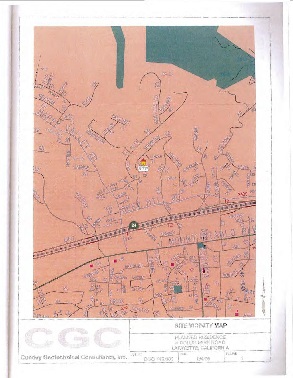
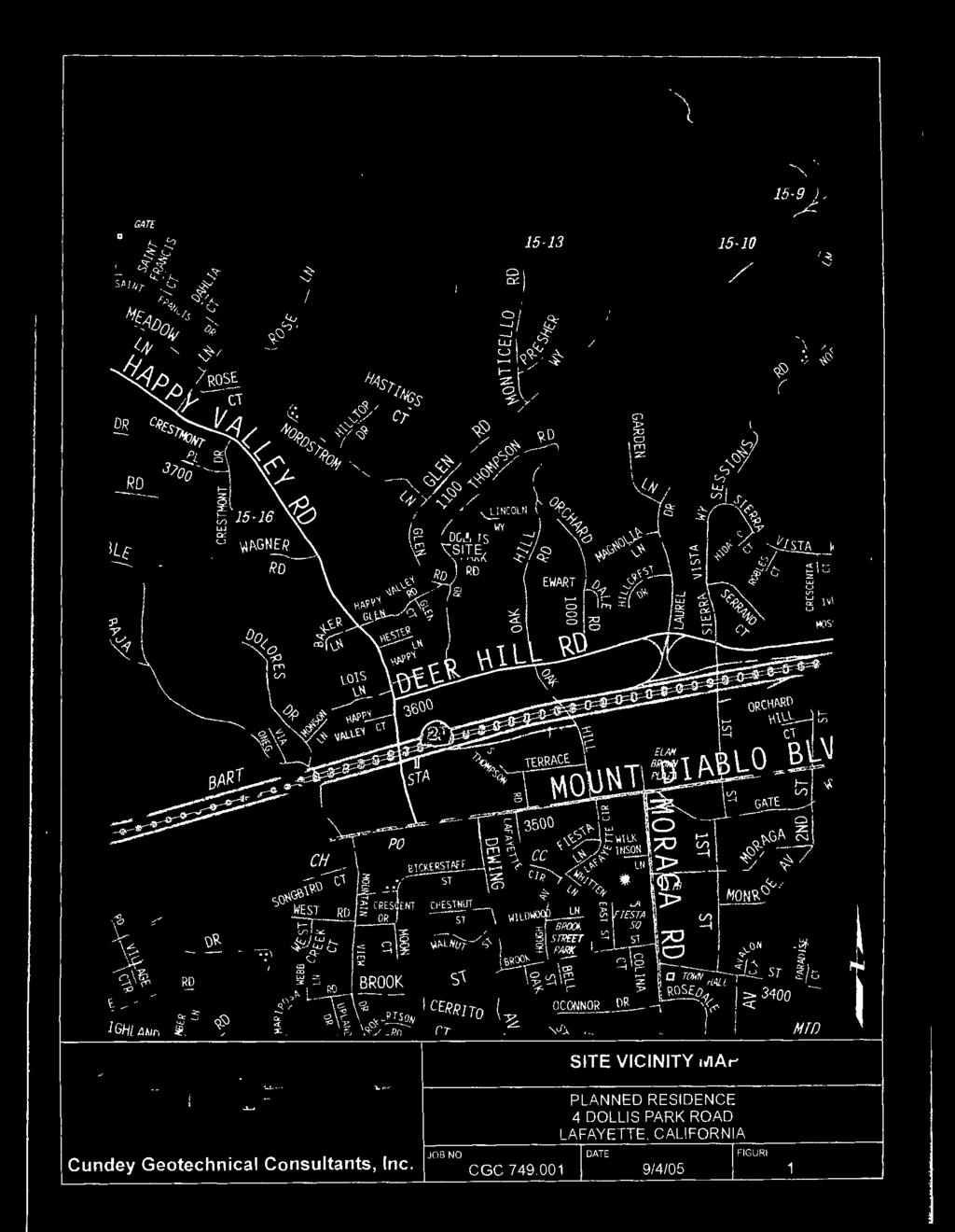
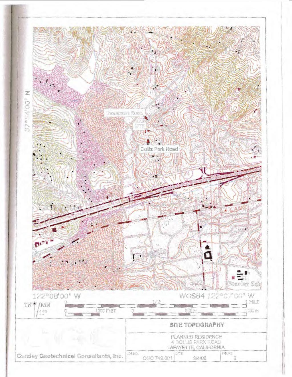
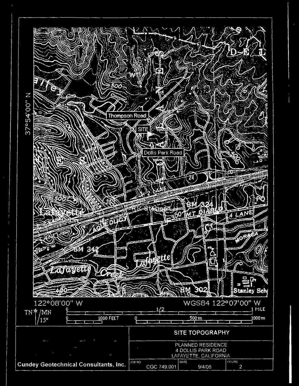
2 Planning Commission HDP15-14 Reddy Staff Report January 20, 2015 Trigger Yes No Trigger Yes No Within a protected ridgeline setback? Grading > 50 cubic yards? Within 100-ft. of a ridgeline setback? DR required as condition of approval? In the Hillside Overlay District? In a commercial or MFR zone? Over 17-ft. in height to ridge? Variance requested? SFR Development > 6,000 sq.ft.? Tree Permit Requested? Creek Setback required? Redevelopment Project Area LOCATION & SITE CONDITIONS Looking north Location: General Plan: Zoning: Topography: Lot Size: Creek / Flood Zone: Looking west Dollis Park Road, off of North Thompson Road (location map attached) Medium Density Single-Family Residential (Up to 6 dwelling units per acre) Single-Family Residential District- 10 (R-10) Steady upslope toward the north 12,155-square feet (0.28 acres) None; Zone X SURROUNDING LAND USES Immediately Adjacent Zoning North Single-Family Residence (One-Story) R-10 South Dollis Park Road R-10 East Single-Family Residence (Two-Story) R-10 West Single-Family Residence (Two-Story) R-10 PROJECT HISTORY DR39-92 Rockey (October 27, 1992): The Zoning Administrator approved an application for a two-story addition to an existing two-story single-family residence. This residence was demolished. Page 2 of 9
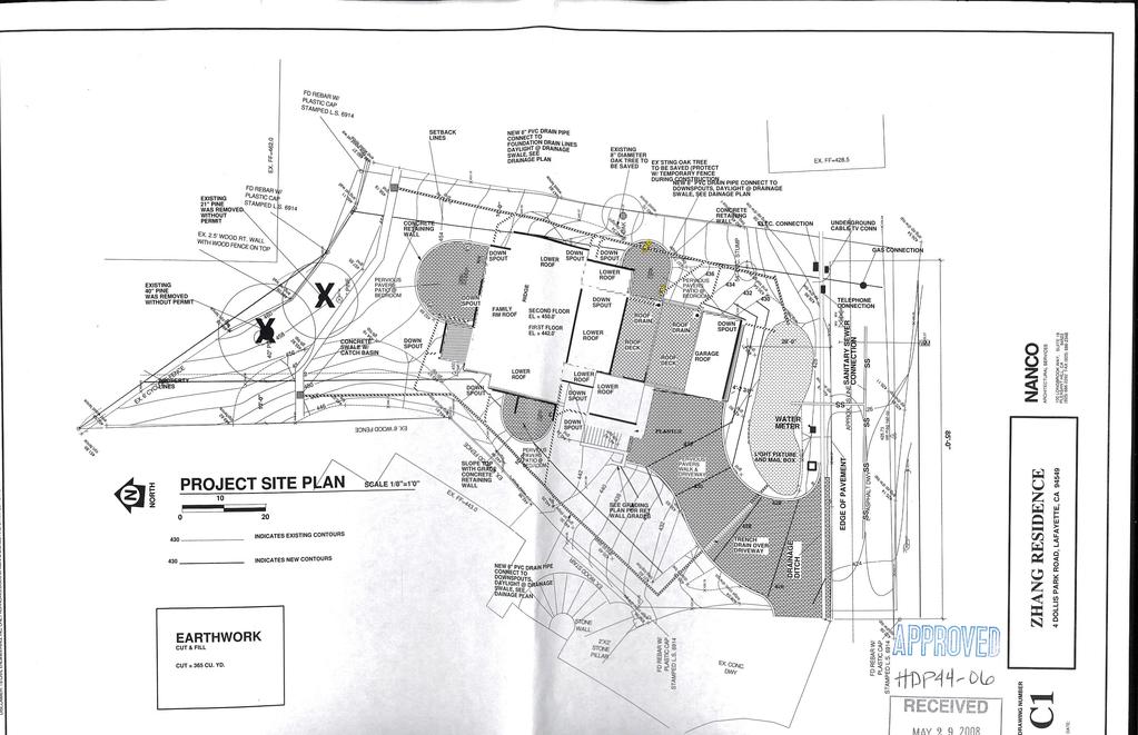
3 Planning Commission HDP15-14 Reddy Staff Report January 20, 2015 Over-the-counter building permit approval (January 8, 2002): The applicant received building permit approval for a new single-family residence as the construction did not trigger design review at that time. The project was not constructed. The Hillside Regulations came into effect on August 8, 2002 and the new proposal is subject to a Hillside Development Permit. SS10-04 DeCarvalho (March 9, 2004): Commission discussed the following issues: Lot coverage. Concern for building from setback to setback. May be built out for the lot size. May want to consider instead a smaller, more compact two-story element. Grade manipulation. May be shoehorning the proposal into the site. Try to make the house fit the topography of the lot as much as possible. Consider a sloping foundation wall. Apparent bulk and mass through continuous roof plane. Provide demonstration. Volume of proposal in proximity to adjacent residences. Colors and materials should be varied. Suggested not all stucco or use of more than one stucco color to break up the bulk and mass. Consider a more consistent design, either more modern or Maybeck style with more material variation. Landscape mitigation would be necessary. HDP46-04 DeCarvalho (October 2004): Commission discussed the following issues: Outdoor living space is inadequate Residence overdevelops the site, with the residence built out from setback to setback Provide softer more natural materials more in context with the neighborhood Provide a landscape plan to address the entire site Submit revised plans with a more appropriate building form and mass Submit an updated soils report Provide neighborhood context The applicant withdrew the application, hired a new architect, and submitted a study session. SS12-05 DeCarvalho (August 2005): Commission discussed the following issues: Terrace the wall to be more creative in the rear yard. Consider eliminating the railing at the entry and making it more landscape oriented Suggested that the siting of the house is appropriate Consider curving the staircase The garage appearing very "blockish" and additional detail requested on the railings. Show existing and proposed grades. At a preliminary review, the house appears tall. Submit a full landscape and drainage plan to adequately address site constraints. Runoff should dissipate onsite instead of a direct connection. Submit shielded light fixtures. The carriage lights are not appropriate Provide a consistent architectural design and style for all elevations and details Work with neighboring properties to address their concerns HDP44-06 DeCarvalho (June 10, 2008): The Design Review Commission approved an application for a 1) Hillside Development Permit, 2) Design Review Permit, 3) Grading Permit, and 4) Variance Permit to construct a new 4,200 sq. ft. two-story single family residence with a ridge building height of 38 ft. at 4 Dollis Park Rd. Page 3 of 9
4 Planning Commission HDP15-14 Reddy Staff Report January 20, 2015 The project was not constructed. At the time this project was approved, there was not a two phase hillside process for undeveloped lots in the Hillside Overlay District and the new proposal is subject to the new process. ENVIRONMENTAL REVIEW Staff evaluated the project in accordance with the California Environmental Quality Act ( CEQA ) and determined the project is categorically exempt under Section 15303, because the project entails the construction of a single-family residence in a residential zone that is already served by public services and is consistent with the General Plan. PUBLIC NOTICE & COMMENTS Property owners within 300 of the subject property were mailed a notice of public hearing, and the immediate area was posted at least ten days prior to the initial scheduled public hearing. At the time this staff report was prepared, the City has received no public comments. REFERRAL AGENCIES COMMENTS The project plans were referred to the Central Contra Costa Sanitary District ( CCCSD ); City Engineer; City Landscape Consultant; Contra Costa County Building Inspection Department ( CCCBID ); and Contra Costa County Fire Protection District ( CCCFPD ). At the time the staff report was prepared, the City has received agency comments, attached, from the CCCSD and CCCBID where neither agency had project specific comments. ANALYSIS & COMMENTS Consistency with the General Plan The General Plan designation for the subject property is Medium Density Single-Family Residential, which allows up to 6-dwelling units per acre. The applicant proposes to construct one unit on a acre parcel which complies with this density. While the proposed residence complies with the density limits, staff does not believe the proposed development complies with the following General Plan goals, policies, and programs: Policy LU-1.1 Scale: Development shall be compatible with the scale and pattern of existing neighborhoods. Refer to the siting and massing section of this staff report. Program LU Apply the City s Residential Design Guidelines to ensure quality design. Refer to the consistency with Residential Design Guidelines, siting, and massing section of this staff report. Consistency with Residential Design Guidelines The siting and massing does not comply with the Residential Guidelines, specifically the following guidelines: Houses with small footprints are encouraged where a site is restricted by existing natural features (Guideline IB2d) The overall scale and square footage of the buildings should relate to existing neighborhood visual scale and square footage (Guideline IIB2d) Consistency with Zoning District Regulations The subject property is located within the Single-Family Residential District - 10 (R-10). The following Page 4 of 9
 10,000 SF 12,155 SF 12,155 SF (no change) Height (max.) 35-0 - 33-4 Stories (max.) 2 ½ Stories - 2 story Front Yard (min.) 20-0 1-20 -0 Side Yard (min.")
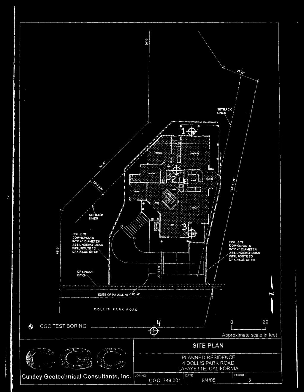
5 Planning Commission HDP15-14 Reddy Staff Report January 20, 2015 table shows consistency of the proposed development with the R-10 regulations: Development Standard Standard Existing Proposed Lot Area (min.) 10,000 SF 12,155 SF 12,155 SF (no change) Height (max.) Stories (max.) 2 ½ Stories - 2 story Front Yard (min.) Side Yard (min.) ~10 and ~10 Aggregate Side Yard (min.) ~20 Rear Yard (min.) ~40 Parking (min.) 2-2 Siting The applicant has submitted a site constraints analysis and proposed one potential building site to evaluate with the constraints analysis. The constraints analysis identifies the following constraints/layers: Setbacks (Sheet A2.1) Vegetation (Sheet A2.2) Slope (Sheet A2.3) Under 30%, 30-50%, and over 50% Composite Overlay (Sheet A2.4) Composite Overlay with Proposed Footprint (Sheet A2.5) Staff finds that the siting of a proposed residence is limited due to the setbacks, configuration of the site, and topography as seen on Sheet A2.5, below. The lot has a steady increase in grade toward the north side (rear) of the property. The elevation changes ~35 from front to back (south to north) of the property. A majority of the buildable area has a percent slope as seen on Sheet A2.4. The topography lends itself well to a residence that steps into the hill. Currently, the proposed residence is not greatly responsive to the grade of the hill. Staff recommends that the applicant use the general shape and layout of the proposed residence, but step it with the hillside to a greater degree. One way this can be done is shifting the upper-story up the hill 1 For application HDP46-04, The Design Review Commission and Planning Department determined that the front setback was to be taken from the edge of pavement where the Dollis Park Road is located, not the edge of the property. See attached page from the staff report on October 12, Page 5 of 9

6 Planning Commission HDP15-14 Reddy Staff Report January 20, 2015 slightly. This would reduce the height of the proposed residence at any given section, and create larger upper-story step backs when viewed from Dollis Park Road, thus reducing the scale of the proposed residence. The relationship of the project to the hillside can be seen on Sheet A3, Section A-A as shown below. Staff also has concerns that currently, there is no outdoor space being proposed. While there does not need to be full design drawings of the outdoor space in Phase I, there should be some consideration of where the outdoor space will be located on-site. Staff recommends that the applicant indicate where on-site outdoor space is planned. Massing The proposal complies with zoning district standards at ~33 in height. The proposed development will be larger than the average house size in the neighborhood, however, the lot size is slightly larger than average for the neighborhood as well. Most of the residences off of Dollis Park Road do have a tall presence on the street because the street is at a lower elevation than most of the properties along it. The subject property included, at ~6-25 above street level where the new residence is proposed. While the houses along Dollis Park Road have a two-story scale in relation to the street and the subject proposal is for a two-story residence, staff finds that the current proposal has a three-story presence along the street. Staff recognizes that the applicant has reduced the mass and height of the residence since the initial plans submitted and appreciates the applicant s effort to reduce the apparent scale of the residence. However, staff is still concerned with the overall three-story scale that is proposed. The two elevations that read the tallest from off-site are the south elevation (which has a three-story presence facing the street) and the west elevation. The west elevation will be 45 away from the residence to the south as the proposed residence spans nearly the entire parcel from side setback to side setback (east to west). South Elevation (facing Dollis Park Road) Page 6 of 9

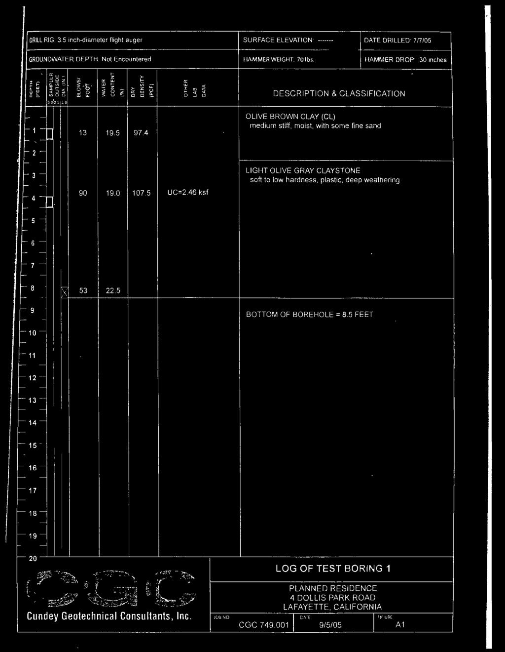
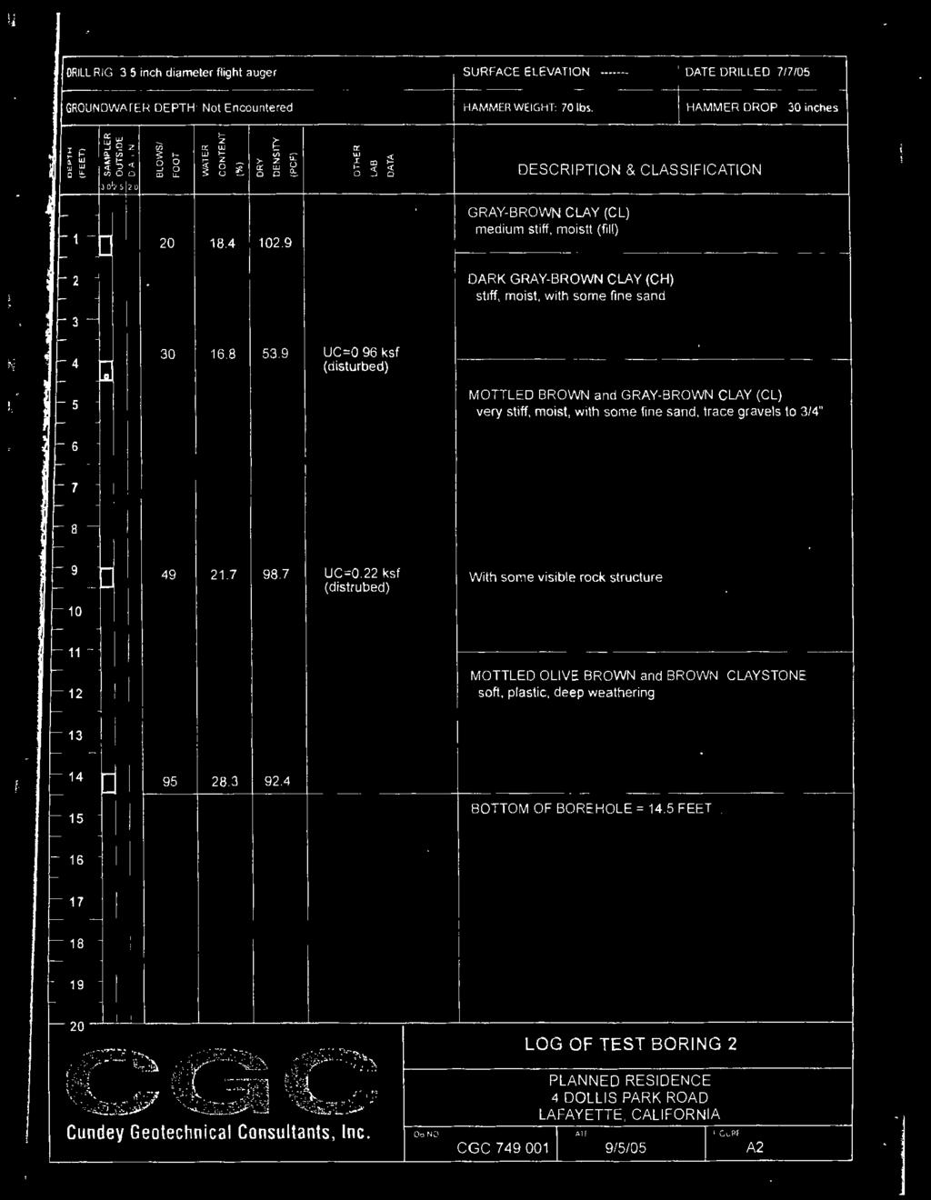
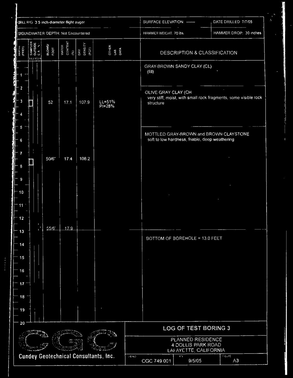
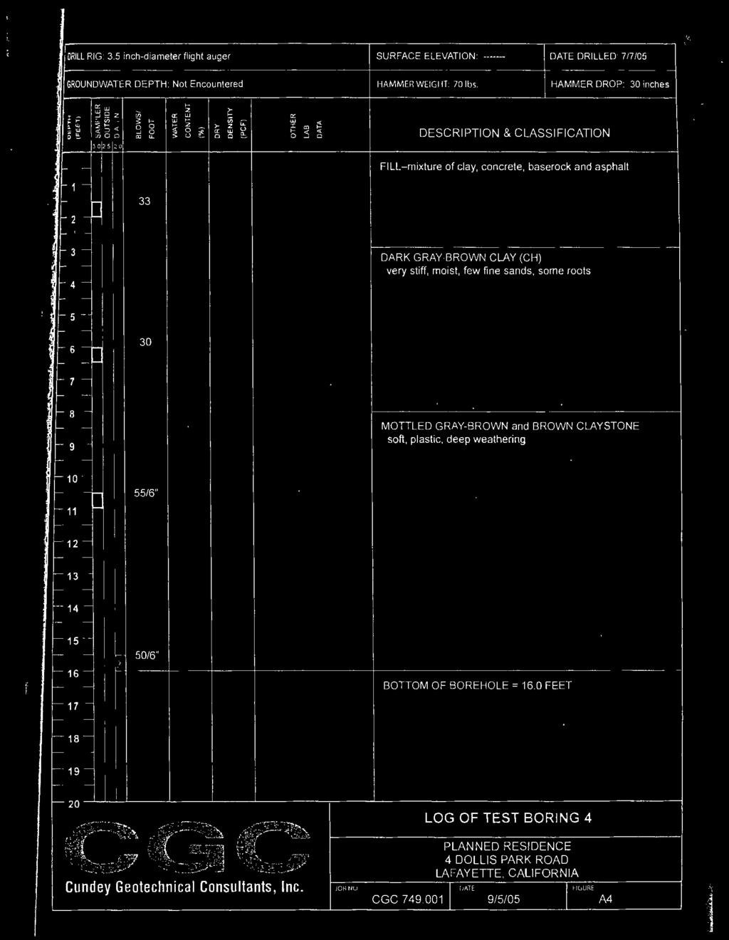
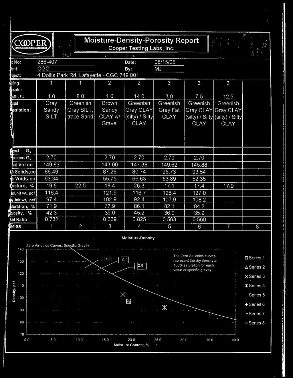
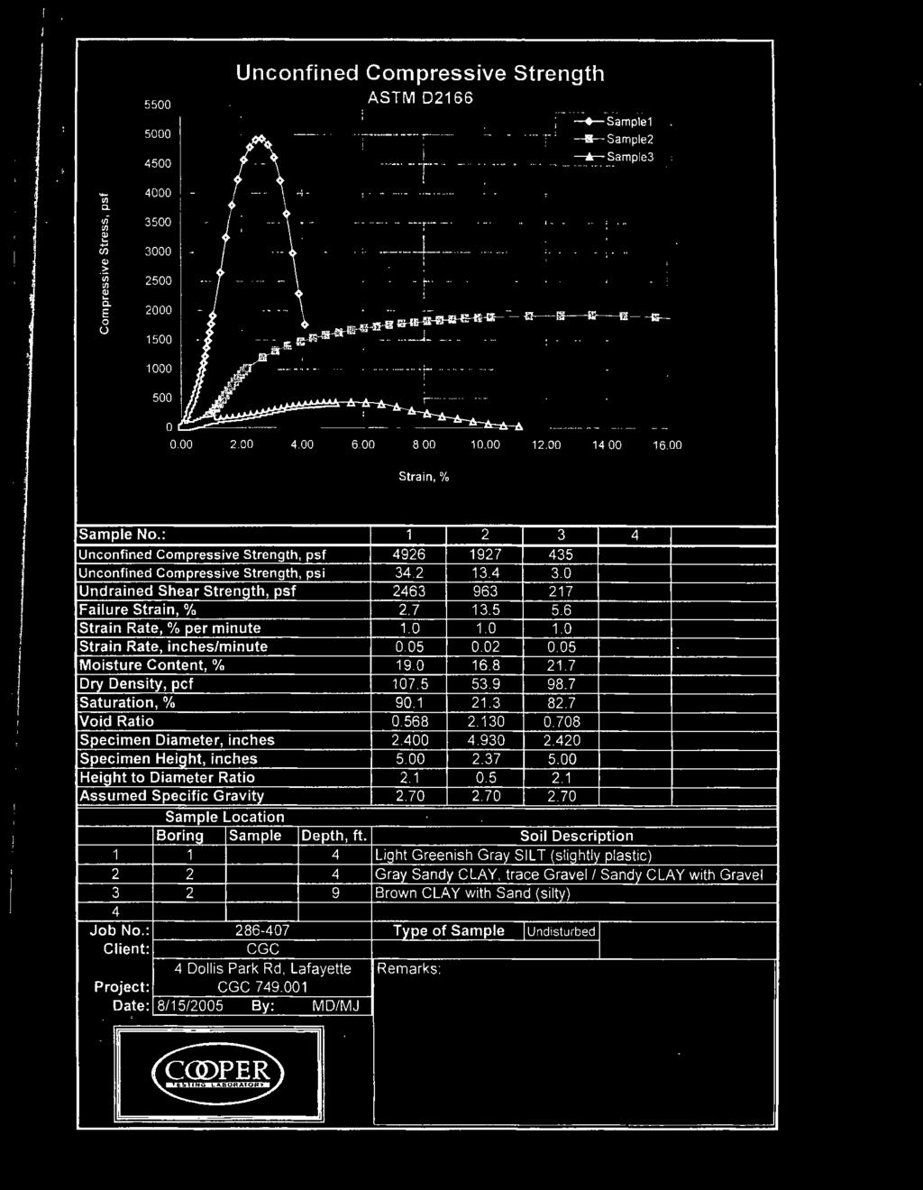
7 Planning Commission HDP15-14 Reddy Staff Report January 20, 2015 West Elevation (facing a neighbor 45 away) Staff finds that there are opportunities to reduce the mass of the residence without compromising the design intent or program of the applicant. Some examples to reduce the overall scale of the proposed residence are to step the residence with the hillside (as previously suggested by Staff in this report), reduce the size of the residence, or lower the finished floor elevation. Lowering the finished floor elevation so that the proposed residence is lower in the hill, will allow the height of the proposed residence to be decreased thus reducing the scale. Grading The applicant is proposing 388 cubic yards of grading (194 CY cut, 194 CY fill). The applicant submitted a geotechnical report prepared by Cundey Geotechnical Associates in 2005 and updated by Peters & Ross in The reports analyze the proposed project and make a number of recommendations including foundations and drainage. The report from 2005 concludes that the site is suitable for the planned residence, and this conclusion is echoed in the report from The geotechnical reports are attached to this report. REQUIRED FINDINGS The Planning Commission must make all of the required findings in order to approve the subject application Findings required for approval of a hillside development permit on an existing lot of record. The hearing authority may approve an application for a hillside development permit on an existing lot of record in the hillside overlay district only after making the following findings: (a) The development is consistent with the applicable goals and policies of the general plan and is in conformance with applicable zoning regulations; (b) The development will preserve open space and physical features, including rock outcroppings and other prominent geological features, streams, streambeds, ponds, drainage swales, native vegetation, native riparian vegetation, animal habitats and other natural features; (c) Structures in the hillside overlay district will, to the extent feasible, be located away from prominent locations such as ridgelines, hilltops, knolls and open slopes; (d) The development, including site design and the location and massing of all structures and improvements will, to the extent feasible: (1) Minimize the loss of privacy to surrounding residents and not unduly impact, restrict or block significant views; (2) Not have a significant visual impact when viewed from lower elevations from public places, using the viewing evaluation map as a guide to establish locations from which views are considered; and (3) Not interfere with a ridgeline trail corridor or compromise the open space or scenic character of the corridor. Page 7 of 9
8 Planning Commission HDP15-14 Reddy Staff Report January 20, 2015 (e) Within 100 feet of a restricted ridgeline area, or when a exception to a ridgeline setback has been granted, the development will result in each structure being substantially concealed by terrain or vegetation when viewed from lower elevations from public places, using the viewing evaluation map as a guide to establish locations from which views are considered; (f) Development grading will be minimized to limit scarring and cutting of hillsides especially for long roads or driveways, preserve existing geologic features, topographic conditions and existing vegetation, reduce short and long-term erosion, slides and flooding, and abate visual impacts; (g) The development provides adequate emergency vehicle access, including turn-around space, to the building site and surrounding on-site undeveloped or isolated areas; (h) Each structure and proposed landscaping complies with the city s residential design guidelines; (i) The new or replacement vegetation for the development is native to the surrounding area in areas abutting open space and natural areas, such as oak woodland, chaparral, grassland and riparian areas, and conforms to the policies of Section ; and (j) The development will not create a nuisance, hazard or enforcement problem within the neighborhood or the city, nor require the city to provide an unusual or disproportionate level of public services Specific findings required for design review. 1. Every provision of this chapter is complied with; 2. The approval of the plan is in the best interest of the public health, safety and general welfare; 3. General site considerations, including site layout, open space and topography, orientation and location of buildings, vehicular access, circulation and parking, setbacks, height, walls, fences, public safety and similar elements have been designed to provide a desirable environment for the development; 4. General architectural considerations, including the character, scale and quality of the design, the architectural relationship with the site and other buildings, building materials, colors, screening of exterior appurtenances, exterior lighting and signing and similar elements have been incorporated in order to ensure the compatibility of this development with its design concept and the character of adjacent buildings; and 5. General landscape considerations, including the location, type, size, color, texture and coverage of plant materials, provisions for irrigation, maintenance and protection of landscaped areas and similar elements have been considered to ensure visual relief, to complement buildings and structures and to provide an attractive environment for the enjoyment of the public General findings for structures over 17 in height. 1. The structure substantially complies with the city's residential design guidelines; 2. The structure is so designed that it will appear compatible with the scale and style of the existing neighborhood and will not significantly detract from the established character of the neighborhood; 3. The structure is so designed that it does not appear too tall or massive in relation to surrounding structures or topography when viewed from off-site; and 4. The structure is so designed that it does not unreasonably reduce the privacy or views of adjacent properties Findings required for approval of grading exceeding 50 cubic yards 1. The grading will not endanger the stability of the site or adjacent property or pose a significant ground movement hazard to an adjacent property. The decision making authority may require the Page 8 of 9
9 Planning Commission HDP15-14 Reddy Staff Report January 20, 2015 project geotechnical engineer to certify the suitability of the project supported by appropriate technical studies, including subsurface investigation; 2. The grading will not significantly increase erosion or flooding affecting the site or other property and will not cause impacts to riparian habitats, stream channel capacity or water quality that cannot be substantially mitigated; 3. The grading, when completed, will result in a building site that is visually compatible with the surrounding land; 4. The grading is sensitive to the existing landforms, topography and natural features on the site; and 5. The design of the project preserves existing trees on the site and trees on adjoining property to the extent possible. CONCLUSION Staff finds that the project is generally well designed; however, the size, scale, height, and mass are out of scale with the neighborhood. As articulated above, staff recommends the following revisions: 1. Revise the project in response to the Commission 2. Reduce the scale of the proposed residence through the following: a. Stepping the residence with the hillside b. Lowering the finished floor elevation c. Reducing the size STAFF RECOMMENDATION Consider the matter, take public testimony, provide direction to the applicant and continue the matter to a future date certain to allow the applicant to make modifications. ATTACHMENTS 1. Aerial Maps & Photos 2. Applicant s response to findings 3. Setback determination Approved plans from HDP Geotechnical Reports a. Updated by Peter & Ross July 1, 2014 b. Prepared by Cundey Geotechnical Associates September 8, Public Agency Referral Comments a. CCCBID b. CCCSD 7. Project Plans, received November 24, 2014 Page 9 of 9

10 4 Dollis Park Road APN CityGIS 300 ft

11 4 Dollis Park Road APN CityGIS 200 ft

12 4 Dollis Park Road APN CityGIS 100 ft

13 4 Dollis Park Road APN CityGIS 40 ft
14 RSR DEVELOPMENT COMPANY Builders / Designers Established 1988 HPD15-14 RESPONSE TO FINDINGS Project Description General The proposal is for a new 3,116 SF residence the design and layout of which comply with all city requirements and guidelines The previous SFR built in 1930 s was removed leaving behind a barren lot completely devoid of any esthetics or landscaping and is a blight upon the neighborhood in every aspect. The new structure will comply with current building, energy and green codes to provide extensive upgrades, energy conservation, structural stability and overall neighborhood appeal and significantly enhance surrounding property values. HILLSIDE DEVELOPMENT: A. Explain how the development is consistent with the applicable goals and policies of the General Plan and is in conformance with applicable zoning regulations. The development meets the spirit and letter of the goals and policies of the general plan. B. Explain how the development will preserve open space and physical features, including rock outcroppings and other prominent geological features, streams, streambeds, ponds, drainage swales, native vegetation, native riparian vegetation, animal habitats and other natural features. The development will preserve open space and physical features. It leaves the lot wide open for the neighbors enjoyment of views. There are no streams, creeks or natural habitat that will be obscured. C. Explain how structures in the Hillside Overlay District will, to the extent feasible, be located away from prominent locations such as ridgelines, hilltops, knolls and open slopes; The constraints provide no choice for the home site. The lot/hill is not part of a ridgeline or hilltop. D. Explain how the development, including site design and the location and massing of all structures and improvements will, to the extent feasible: 1. Minimize the loss of privacy to surrounding residents and not unduly impact, restrict or block significant views; The home site and development proposal is perfectly situated to have little if any impact on privacy or views for surrounding residents. 2. Not have a significant visual impact when viewed from lower elevations from public places, using the viewing evaluation map as a guide to establish locations from which views are considered; and
15 The proposal will not create any silhouettes from lower elevations, as it is back-dropped by the rest of the hill above, and by much larger, higher structures and existing vegetation along the uphill. 3. Not interfere with a ridgeline trail corridor or compromise the open space or scenic character of the corridor. n/a E. Within 100 feet of a restricted ridgeline area, or when a exception to a ridgeline setback has been granted, explain how the development will result in each structure being substantially concealed by terrain or vegetation when viewed from lower elevations from public places, using the Viewing Evaluation Map as a guide to establish locations from which views are considered. n/a F. Explain how development grading will be minimized to limit scarring and cutting of hillsides especially for long roads or driveways, preserve existing geologic features, topographic conditions and existing vegetation, reduce short and long term erosion, slides and flooding, and abate visual impacts. Because the massing is driven by the contours, it minimizes cut and fill. The massing will harmonize with the shape of the hill. There will be low water/native plantings proposed, and therefore minimal irrigation will be needed in the area. G. Explain how the development provides adequate emergency vehicle access, including turn around space, to the building site and surrounding on site undeveloped or isolated areas. No special emergency access is required. H. Explain how each structure and proposed landscaping complies with the City s Residential Design Guidelines. The massing of the house has been carefully designed with the intent of Lafayette s Residential Design Guidelines. It responds to the contours of the property and provides proportions that are so important to Lafayette s traditional hillside building stock. Landscaping will be used to enhance privacy and views of neighbors. I. Explain how the new or replacement vegetation for the development is native to the surrounding area in areas abutting open space and natural areas, such as oak woodland, chaparral, grassland and riparian areas, and conforms to the following policies, pursuant to Section : New or replacement vegetation in an area abutting open space and natural areas, such as oak woodland, chaparral, grassland and riparian areas, excluding planting for erosion control or land stabilization, shall be native to the surrounding area. The goal of the planting should be a seamless blending with the natural vegetation. The reviewing authority may grant an exception to this requirement for a small garden area near the home provided it is not visible from public places and contains no non native trees or shrubs over six feet in height, or large green expanses. There will be low water/native plantings proposed per section , and therefore minimal irrigation will be needed in the area. J. Explain how the development will not create a nuisance, hazard or enforcement problem within the neighborhood or the city, nor require the city to provide an unusual or disproportionate level of public services. No special nuisance is foreseeable and extensive engineering will insure stability and safety of the neighborhood.
16 DESIGN REVIEW Specific Findings Required for Design Review. 1. Every provision of this chapter is complied with; 2. The approval of the plan is in the best interest of the public health, safety and general welfare; The proposed new residence is in keeping with all current City design requirements, standards, and regulations. The previous SFR built in 1930 s was removed leaving behind a barren lot completely devoid of any esthetics or landscaping and is a blight upon the neighborhood in every aspect. The new structure will comply with current building, energy and green codes to provide extensive upgrades to energy conservation, structural stability and overall neighborhood appeal and significantly enhance surrounding property values. 3. General site considerations, including site layout, open space and topography, orientation and location of buildings, vehicular access, circulation and parking, setbacks, height, walls, fences, public safety and similar elements have been designed to provide a desirable environment for the development; The proposed new residence will be sited within all required Setbacks, following the natural contours of the property and slightly forward of where the previous structure was located, leaving existing rear planting area and the hillside virtually undisturbed. Parking circulation is a huge problem in the area at present, multiple additional off street parking spaces are proposed; over and above what is required and where existing street parking is currently non-existent. 4. General architectural considerations, including the character, scale and quality of the design, the architectural relationship with the site and other buildings, building materials, colors, screening of exterior appurtenances, exterior lighting and signing and similar elements have been incorporated in order to ensure the compatibility of this development with its design concept and the character of adjacent buildings; and The proposed new residence will greatly enhance the existing neighborhood and bring it to keeping with the character, scale and quality of existing adjacent Homes, actually becoming a prominent and unique design compliment. 5. General landscape considerations, including the location, type, size, color, texture and coverage of plant materials, provisions for irrigation, maintenance and protection of landscaped areas and similar elements have been considered to ensure visual relief, to complement buildings and structures and to provide an attractive environment for the enjoyment of the public. The proposed new residence will be planted with low-water, native plantings to bring the site to current neighborhood standards and conditions as opposed to the current barren lot completely devoid of any esthetics or landscaping.
17 Findings for Structures Over 17 ft. in Height 1. The structure substantially complies with the city's residential design guidelines; 2. The structure is so designed that it will appear compatible with the scale and style of the existing neighborhood and will not significantly detract from the established character of the neighborhood; The proposed new residence will greatly enhance the existing neighborhood and bring it to keeping with the character, scale and quality of existing adjacent Homes, actually becoming a prominent and unique design compliment. 3. The structure is so designed that it does not appear too tall or massive in relation to surrounding structures or topography when viewed from off site; 4. The structure is so designed that it does not unreasonably reduce the privacy or views of adjacent properties. The proposed new residence will be two stories (massing contoured naturally) within the maximum height of 35 feet.. It will be set with the backdrop of the hillside and foliage as viewed from the street. Any views from adjacent properties are minimal due to the steep hillside to the left and existing trees on the right. GRADING 1. The grading will not endanger the stability of the site or adjacent property or pose a significant ground movement hazard to an adjacent property. See Soils Report attached ; extensive engineering will insure stability and safety of the neighborhood 2. The grading will not significantly increase erosion or flooding affecting the site or other property and will not cause impacts to riparian habitats, stream channel capacity, or water quality that cannot be substantially mitigated. There are no riparian features to be impacted. 3. The grading, when completed, will result in a building site that is visually compatible with the surrounding land. 4. The grading is sensitive to the existing landforms, topography, and natural features on the site. Because the massing is driven by the contours, it minimizes cut and fill. The massing will harmonize with the shape of the hill. 5. The design of the project preserves existing trees on the site and trees on adjoining property to the extent possible. 6. Arborist recommendations for retained trees, if any, are incorporated into the grading plan. No trees are proposed to be removed for the project, the design of the project protects the one existing tree which shall be additionally protected during construction.
18 Design Review Commission October 12, 2004 Staff Report HDP46-04 DeCarvalho The applicant s soil engineer, Buller Group, prepared a geotechnical report dated February 7, 2001 addressing the construction of a new single-family residence. The report concluded that that the site is suitable for the proposed development, subject to the recommendations stated within the report. Refer to the attachments. Analysis and Comments Architectural design: In response to the Design Review Commission, the applicant has incorporated stone into the architectural design to break up the materials on the front elevation. The upper deck about the garage has opened up with the use of open railing to reduce the bulk of frontage. The applicant has also varied the use of the half-arch windows to give the elevation some visual relief. Otherwise, not many changes were made to the plans from the study session. While the changes incorporated from the study session are improvements, staff suggests that the issue of developing from setback to setback is still an issue that has not been addressed. The design maintains a single-story design but may be overdeveloping the site. The proximity of the adjacent residences further impacts the proposal, particularly the residence to the west. Staff suggests that a more compact building footprint with an upper story may be more appropriate. In addition staff questions if the proposal could be further bunkered down into the hillside to minimize the bulk and mass. The overall height may also be reduced by lowering the plate heights. Setbacks: The zoning for the proposal is that of the R-10 zoning district. In the circumstance that an access easement is within the front yard, setbacks are taken from the easement line instead of the property line. The access on Dollis Park is not a straightforward. While the street is private, the physical location of the access easement is different on paper than it is onsite. Refer to the attached aerial. Dollis Park Road ( ) Area actually used for the access easement ( ) As such, access to parcel is through (4 Dollis Park). According to the title report, there is no access easement for the portion of roadway that runs through 4 Dollis Park. The surveyor is staking the area and will be providing a surveyed plan to verify this. Therefore, Planning Services Division has agreed to take the front yard setbacks from the edge of pavement. Landscaping: Page 4 of 7
19
20
21
22
23
24
25
26 Peters & Ross Geotechnical & Geoenvironmental Consultants July 1, 2014 Project No Mr. Ravi Reddy RSR Development Company 3000F Danville Blvd., #268 Alamo, CA Geotechnical Update Reddy Residence, 4 Dollis Park Road, Lafayette, California Dear Mr. Reddy: In accordance with your request, Peters & Ross reviewed Cundey Geotechnical Consultants, Inc. (CGC) report dated September 8, 2005, Project No Mr. Reddy requested that Peters & Ross provide this update letter and assume the role of geotechnical engineer of record. It is our opinion that from a geotechnical perspective, the conclusions and recommendations provided by CGC, with the exception of the seismic design parameters, apply to the planned residence. Seismic Concerns In accordance with Section 1613 of the 2013 CBC, Peters & Ross classifies the site as a C Site Class with a latitude of degrees and a longitude of degrees. The CBC parameters presented in the following table should be used for seismic design. PERIOD (sec) SPECTRAL RESPONSE Ss, Sl SITE COEFFICIENT Fa, Fv (SITE CLASS C) MAXIMUM SPECTRAL RESPONSE Sms, Sml DESIGN SPECTRAL RESPONSE SDs, SDl The site is not within an Alquist-Priolo Earthquake Fault Zone, and therefore the risk of fault rupture at the site is remote. No loose, clean sands were observed in the test boring. Therefore, the risk of significant foundation settlement due to liquefaction or densification during a large magnitude earthquake is low. Plan Review and Construction Observation and Testing Services Peters & Ross should review project plans, to check that the geotechnical engineering recommendations contained in this letter are properly incorporated. We should provide geotechnical observation services on an as-needed basis during construction, to check that geotechnical aspects of the work are completed in accordance with the plans. These services 114 Hopeco Road, Pleasant Hill, CA Phone: (925) Fax: (925) PetersRoss@aol.com

27 Reddy Residence July 1, 2014 Project No Page 2 of 2 should include observing foundation excavation and providing consultation to the contractor regarding any geotechnical concerns that arise during construction. Peters & Ross cannot accept responsibility for geotechnical aspects of construction that are not observed by its staff. Peters & Ross will make every reasonable effort to accommodate the contractor s work schedule during construction, so that necessary observations can be performed in a timely manner to avoid construction delays. However, since our field services are often required on several projects concurrently, we request that 48 hours advance notice be given for site visits, in order to minimize scheduling conflicts. Limitations Peters & Ross services consist of professional opinions and recommendations that are made in accordance with generally accepted geotechnical engineering principles and practices. The opinions and recommendations presented in this update letter are based on a review of the work performed by CGC, and our site meeting with Mr. Reddy. This warranty is in lieu of all other warranties either expressed or implied. If you have any questions, please call. Sincerely, Peter K. Mundy, P.E., G.E. Geotechnical Engineer Hopeco Road, Pleasant Hill, CA Phone: (925) Fax: (925) PetersRoss@aol.com
28
29

30

31
32


33

34
35

36

37

38

39

40

41
42
43
44

45

46

47
48
49
50
51
52

53
54
55 Canales, Megan Subject: FW: Referral HDP15-14, 4 Dollis Park Road From: Thom Huggett [mailto:thom.huggett@dcd.cccounty.us] Sent: Tuesday, January 13, :40 AM To: Canales, Megan Subject: RE: Referral HDP15-14, 4 Dollis Park Road Hi Megan, I have no comments at this time. Thom Huggett, PE, SE Principal Structural Engineer Lamorinda Building Inspection Office 3685 Mt. Diablo Blvd., Suite 120 Lafayette, CA (925) (925) fax thom.huggett@dcd.cccounty.us 1
56 Canales, Megan From: Sent: To: Subject: Follow Up Flag: Flag Status: Russ Leavitt Tuesday, January 13, :45 AM Canales, Megan HDP15-14; replacement residence, 4 Dollis Park Road, Lafayette Follow up Flagged The property has received Central Contra Costa Sanitary District (CCCSD) sanitary sewer service and the replacement residence would not be expected to produce an unmanageable added capacity demand on the wastewater system, nor interfere with existing facilities. The applicant must submit full-size building plans for CCCSD to review and pay all appropriate fees, including for capping and abandoning or inspecting the existing sewer lateral for reuse. For more information, the applicant should contact the CCCSD Permit Section at (925) Thanks! Russell B. Leavitt Engineering Assistant III Central Contra Costa Sanitary District (CCCSD) 5019 Imhoff Place Martinez, CA v (925) f (925) rleavitt@centralsan.org 1
City of Lafayette Study Session Staff Report Design Review Commission
 ++ City of Lafayette Study Session Staff Report Design Review Commission Meeting Date: January 08, 2018 Staff: Subject: Chris Juram, Planning Technician SS12-17 Miramar Homebuilders, R-20 Zoning: Request
City of Lafayette Staff Report
 City of Lafayette Staff Report For: By: Design Review Commission Greg Wolff, Senior Planner Meeting Date: April 27, 2015 Subject: SS03-15 Gundi & Peter Younger (Owners), R-40 Zoning: Request for a Study
City of Lafayette Study Session Staff Report Design Review Commission
 City of Lafayette Study Session Staff Report Design Review Commission Meeting Date: April 24, 2017 Staff: Payal Bhagat, Senior Planner Subject: HDP18-15 & HDP31-15 Ramesh Patel & Melcor Development (Owners),
City of Lafayette Staff Report
 City of Lafayette Staff Report For: By: Planning Commission Megan Canales, Planning Technician Meeting Date: April 6, 2015 Subject: Deadline: HDP15-14 RSR Development Company (Owners) R-10 Zoning: Request
COMPLIANCE CHECKLIST HILLSIDE RESIDENTIAL DESIGN GUIDELINES MANUAL
 COMPLIANCE CHECKLIST HILLSIDE RESIDENTIAL DESIGN GUIDELINES MANUAL The following checklist summarizes development guidelines and standards. See the appropriate section for a complete explanation of the
City of Lafayette Study Session Project Data
 City of Lafayette Study Session Project Data For: Design Review Commission By: Michael P. Cass, Senior Planner Date: August 24, 2015 Property Address: 954 Mountain View Drive APN: 243-070-011 Zoning District:
City of Lafayette Staff Report
 City of Lafayette Staff Report For: By: Design Review Commission Greg Wolff, Senior Planner Meeting Date: November 25, 2013 Subject: L03-11 O BRIEN LAND CO., LLC (APPLICANT), AMD FAMILY TRUST (OWNER),
CITY OF LAGUNA BEACH COMMUNITY DEVELOPMENT DEPARTMENT STAFF REPORT DESIGN REVIEW BOARD IBOARD OF ADJUSTMENT Coast Highway APN
 CITY OF LAGUNA BEACH COMMUNITY DEVELOPMENT DEPARTMENT STAFF REPORT HEARING DATE: October 13,2011 TO: DESIGN REVIEW BOARD IBOARD OF ADJUSTMENT CASE: Variance 7717 Design Review 11-163 Coastal Development
GENERAL PLAN CONSISTENCY ANALYSIS
 GENERAL PLAN CONSISTENCY ANALYSIS Prepared by Planning Staff 10/28/2013 APPLICABLE GOALS, POLICIES AND PROGRAMS FROM the LAND USE CHAPTER Goal LU-1 Policy LU-1.1 Policy LU-1.2 Goal LU-2 Protect the character
Example Codes. City of Brentwood, Tennessee Brentwood Hillside Protection Overlay District Summary
 Example Codes City of Brentwood, Tennessee Brentwood Hillside Protection Overlay District Summary The City of Brentwood in July 2007 adopted a Hillside Protection (HP) Overlay District to address the problems
A. General Plan: Land Use, Growth Management and the Built Environment Element. d. Use visually unobtrusive building materials.
 Chapter 16 Hillside Protection 16.010 Purpose This chapter establishes the regulations for development and alteration of properties in hillside and ridgeline areas in order to preserve the essential scenic
City of Lafayette Staff Report
 City of Lafayette Staff Report For: By: Design Review Commission Sarah Allen, Associate Planner Meeting Date: May 23, 2016 Subject: Deadline: HDP04-16 Joe Egan (Owner) R-20 Zoning: Request for (1) a Hillside
14825 Fruitvale Ave.
 REPORT TO THE PLANNING COMMISSION Meeting Date: August 26, 2015 Application: PDR14-0017 Location/APN: 14825 Fruitvale Ave. / 397-18-028 Applicant/Owner: Staff Planner: Sin Yong Michael Fossati 14825 Fruitvale
ARTICLE IV: DEVELOPMENT STANDARDS 404 MASTER PLANNING
 IV 13 404 MASTER PLANNING Master Planning through the Site Analysis (Master Planning Site Analysis) or Planned Development (Master Planning Planned Development) is provided to encourage development which
PLANNING COMMISSION AGENDA REPORT SEPTEMBER 1, 2016
 PLANNING COMMISSION AGENDA REPORT SEPTEMBER 1, 2016 TO: Members of the Planning Commission FROM: Michael Klein, Planner FILE NO.: 150000780 PROPOSAL: APPLICANT: RECOMMENDATION: A request for a Site Plan
DECISION CRITICAL AREAS ALTERATION AND DETERMINATION OF NONSIGNIFICANCE (DNS)
") DECISION CRITICAL AREAS ALTERATION AND DETERMINATION OF NONSIGNIFICANCE (DNS) Development Services Department 17301 133rd Avenue NE Woodinville, WA 98072 425-489-2754 www.ci.woodinville.wa.us Project Name:
DECISION CRITICAL AREAS ALTERATION AND DETERMINATION OF NONSIGNIFICANCE (DNS) Development Services Department 17301 133rd Avenue NE Woodinville, WA 98072 425-489-2754 www.ci.woodinville.wa.us Project Name:
PLANNED DEVELOPMENT (MASTER PLAN & UNIT PLAN)
") Central Permit Center 555 Santa Clara Street Vallejo CA 94590 Business License Building Fire Prevention Planning Public Works 707.648.4310 707.648.4374 707.648.4565 707.648.4326 707.651.7151 PLANNED DEVELOPMENT
Central Permit Center 555 Santa Clara Street Vallejo CA 94590 Business License Building Fire Prevention Planning Public Works 707.648.4310 707.648.4374 707.648.4565 707.648.4326 707.651.7151 PLANNED DEVELOPMENT
Site Design (Table 2) Fact Sheet & Focus Questions:
 Fact Sheet & Focus Questions:") Site Design (Table 2) Fact Sheet & Focus Questions: BACKGROUND WHAT IS SITE DESIGN? Site design refers to the arrangement of buildings and open spaces on adjacent sites to maximize the shared benefits
Site Design (Table 2) Fact Sheet & Focus Questions: BACKGROUND WHAT IS SITE DESIGN? Site design refers to the arrangement of buildings and open spaces on adjacent sites to maximize the shared benefits
Project phasing plan (if applicable) 12 copies of site plan
 12 copies of site plan") SITE PLAN REVIEW PERMIT APPLICATION City of Grand Haven, 11 N. Sixth Street, Grand Haven, MI 49417 Phone: (616) 847-3490 Fax: (616) 844-2051 Website: www.grandhaven.org 1. Project Information Address/location
SITE PLAN REVIEW PERMIT APPLICATION City of Grand Haven, 11 N. Sixth Street, Grand Haven, MI 49417 Phone: (616) 847-3490 Fax: (616) 844-2051 Website: www.grandhaven.org 1. Project Information Address/location
RESIDENTIAL GUIDELINES CHECKLIST
 RESIDENTIAL GUIDELINES CHECKLIST The following checklist was created to provide you with an easy way to ensure that your project complies with the Residential Design Guidelines. RESIDENTIAL DESIGN GUIDELINES
File No (Continued)
") (Continued) Request for: (1) a Site Plan Review; (2) a Variance (to build on a significant ridgeline); (3) an Oak Tree Permit (to encroach into the protected zone of 25 oak trees and for potential thinning
(Continued) Request for: (1) a Site Plan Review; (2) a Variance (to build on a significant ridgeline); (3) an Oak Tree Permit (to encroach into the protected zone of 25 oak trees and for potential thinning
DESIGN REVIEW COMMITTEE AGENDA ITEM
 DESIGN REVIEW COMMITTEE AGENDA ITEM AGENDA DATE: OCTOBER 17, 2012 TO: Chair Woollett and Members of the Design Review Committee THRU: FROM: SUBJECT: Leslie Aranda Roseberry, Planning Manager Daniel Ryan,
PLANNING COMMISSION AGENDA REPORT APRIL 7, 2016
 PLANNING COMMISSION AGENDA REPORT APRIL 7, 2016 TO: FROM: Members of the Planning Commission Talyn Mirzakhanian, Senior Planner FILE NO.: 160001710 PROPOSAL: APPLICANT: RECOMMENDATION: A request for a
-MENDOCINO COUNTY PLANNING AND BUILDING SERVICES- DIVISION II OF TITLE 20--COASTAL ZONING CODE
 CHAPTER 20.504 VISUAL RESOURCE AND SPECIAL TREATMENT AREAS Sec. 20.504.005 Applicability. Sec. 20.504.010 Purpose. Sec. 20.504.015 Highly Scenic Areas. Sec. 20.504.020 Special Communities and Neighborhoods.
ORDINANCE NO WHEREAS, the City of Kalama has many areas of timberland and open areas inside its City limits adjacent to residential areas;
 ORDINANCE NO. 1342 AN ORDINANCE OF THE CITY OF KALAMA, WASHINGTON ADOPTING A NEW KALAMA MUNICIPAL CODE CHAPTER 17.20 ESTATE LOT FLOATING ZONE TO PROVIDE TRANSITIONAL ZONING OPTIONS FOR RESIDENTIAL DEVELOPMENT
BOARD~ ADJUSTMENTIDESIGN RE ~WBOARD PROJECT OVERVIEW
 BOARD~ ADJUSTMENTIDESIGN RE ~WBOARD PROJECT OVERVIEW LOCATION: REQUESTED ACTION: EXISTING APPROVALS: ZONING: ADDITIONAL REFERENCES: REQUIRED FINDINGS: STAFF COMMENTS: Site Address: 2165 Temple Hills Drive
APPENDIX C: HILLSIDE DEVELOPMENT REGULATIONS (prev. Ordinance #2008-1)
") APPENDIX C: HILLSIDE DEVELOPMENT REGULATIONS (prev. Ordinance #2008-1) 1. PURPOSE: The purpose of this section is to define the conditions under which hillside development may occur that will not result
APPENDIX C: HILLSIDE DEVELOPMENT REGULATIONS (prev. Ordinance #2008-1) 1. PURPOSE: The purpose of this section is to define the conditions under which hillside development may occur that will not result
RESOLUTION NO
 RESOLUTION NO. 2018- RESOLUTION OF THE PLANNING COMMISSION OF THE CITY OF BELMONT APPROVING A SINGLE-FAMILY DESIGN REVIEW AND TREE REMOVAL PERMIT FOR A VACANT LOT ON LOWER LOCK AVENUE (APN: 043-042-750,
Town of Windham. Planning Department 8 School Road Windham, ME voice fax
 Town of Windham Planning Department 8 School Road Windham, ME 04062 voice 207.864-5960 fax 207.892.1916 MEMO DATE: TO: Staff Review Committee FROM: Amanda Lessard, Planner Cc: Ellen Rathbone, St. Germain
DATE: PLANNING COMMISSION MEETING OF FEBRUARY 24, 2016
 DATE: PLANNING COMMISSION MEETING OF FEBRUARY 24, 2016 TO: FROM: SUBJECT: THE PLANNING COMMISSION LISA COSTA SANDERS, TOWN PLANNER REQUEST FOR A SPECIAL STRUCTURES PERMIT FOR A POOL IN THE SIDE YARD AND
CITY OF LAGUNA BEACH COMMUNITY DEVELOPMENT DEPARTMENT STAFF REPORT. Design Review Coastal Development Permit 10-63
 CITY OF LAGUNA BEACH COMMUNITY DEVELOPMENT DEPARTMENT STAFF REPORT HEARING DATE: TO: CASE: APPLICANT: LOCATION: ENVIRONMENTAL STATUS: PREPARED BY: December 2, 2010 DESIGN REVIEW BOARD Design Review 10-198
Chapter 3 Site Planning and Low Impact Development
 CHAPTER 3 Site Planning and Low Impact Development Chapter 3 Site Planning and Low Impact Development 3.0 Introduction The City of Charleston requires that major residential, large commercial (>1 acre),
Design Review Application *Please call prior to submittal meeting to determine applicable fees*
 CITY OF EAGLE 660 E. Civic Lane, Eagle, ID 83616 Phone#: (208) 939-0227 Fax: (208) 938-3854 Design Review Application *Please call prior to submittal meeting to determine applicable fees* FILE NO.: CROSS
HICKORY NUT FOREST DESIGN GUIDELINES
 HICKORY NUT FOREST DESIGN GUIDELINES Introduction Hickory Nut Forest is a "net-zero energy", conservation development that is designed to protect and celebrate the property s unique ecology. A conservation
Planning Commission Staff Report February 19, 2009
 Planning Commission Staff Report February 19, 2009 Project: Warda Warehouse File: EG-08-051 Request: Design Review Location: 9260 Bendel Place APNs: 134-0660-004 Planner: Gerald Park Property Owner/Applicant
Notice of Preparation of an Environmental Impact Report and Scoping Meeting for the Canyon Lane Roadway Improvements Development Project
 of an Environmental Impact Report and Scoping Meeting for the As the Lead Agency, the County of San Mateo (County) will prepare an Environmental Impact Report (EIR) for the (project), and would like your
At Your Disposal CUP Amendment, Lot 20, Village Service Commercial, at 128 Bastille Dr. (PLN17-208)
") MEMORANDUM Archuleta County Development Services Planning Department 1122 HWY 84 P. O. Box 1507 Pagosa Springs, Colorado 81147 970-264-1390 Fax 970-264-3338 TO: Archuleta County Planning Commission FROM:
MEMORANDUM Archuleta County Development Services Planning Department 1122 HWY 84 P. O. Box 1507 Pagosa Springs, Colorado 81147 970-264-1390 Fax 970-264-3338 TO: Archuleta County Planning Commission FROM:
DESIGN REVIEW COMMITTEE AGENDA ITEM
 DESIGN REVIEW COMMITTEE AGENDA ITEM AGENDA DATE: OCTOBER 3, 2012 TO: Chair Woollett and Members of the Design Review Committee THRU: FROM: SUBJECT: Leslie Aranda Roseberry, Planning Manager Daniel Ryan,
Infill Residential Design Guidelines
 Infill Residential Design Guidelines Adopted March 23, 2004 Amended September 10, 2013 City of Orange Community Development Department Planning Division Phone: (714) 744-7220 Fax: (714) 744-7222 www.cityoforange.org
COUNTY OF SANTA CRUZ MEMORANDUM. To: Don Bussey, Zoning Administrator From: Lawrence Kasparowitz, Project Planner
 1 - COUNTY OF SANTA CRUZ I MEMORANDUM Date: June 21,2006 To: Don Bussey, Zoning Administrator From: Lawrence Kasparowitz, Project Planner Re: 02-0432 Agenda Date: July 21, 2006 Agenda Item #: 0.1 Time:
Planning Commission Staff Report June 5, 2008
 Owner/Applicant Taylor Village Sacramento Investments Partners, LP c/o Kim Whitney 1792 Tribute Road #270 Sacramento, CA 95815 Staff Recommendation Planning Commission Staff Report Project: File: Request:
ARTICLE 17 SITE PLAN REVIEW
 ARTICLE 17 SITE PLAN REVIEW 17.01 INTENT AND PURPOSE The intent of this section is to provide for consultation and cooperation between the applicant and the township planning commission so that the applicant
PC RESOLUTION NO
 PC RESOLUTION NO. 14-01-14-02 TENTATIVE TRACT MAP fttm) 17441. REZONE {RZ) 13-003, ARCHITECTURAL CONTROL (AC) 13-003, TREE REMOVAL PERMIT (TRP) 13-052. GRADING PLAN MODIFICATION (GPM) 13-002. CONDITIONAL
Design Review Commission Report
 City of Beverly Hills Planning Division 455 N. Rexford Drive Beverly Hills, CA 90210 TEL. (310) 285-1141 FAX. (310) 858-5966 Design Review Commission Report Meeting Date: Thursday, March 2, 2017 Subject:
HILLSIDE BUILDING COMMITTEE PLAN REVIEW DIRECTIONS
 HILLSIDE BUILDING COMMITTEE PLAN REVIEW DIRECTIONS 1 1. Review Hillside Regulations to ensure your design is in conformance with current Town Code. 2. Complete page 3 and contact Paul Mood at 480-348-3573,
THE CITY COUNCIL OF THE CITY OF SAN JUAN BAUTISTA DOES HEREBY ORDAIN AS FOLLOWS:
 ORDINANCE NO. 2016 01 AN ORDINANCE OF THE CITY OF SAN JUAN BAUTISTA AMENDING THE SAN JUAN BAUTISTA MUNICIPAL CODE TO ADD CHAPTER 11-08 HILLSIDE DEVELOPMENT REGULATIONS WHEREAS, the City Council has reviewed
F. The following uses in the HR District: attached single-family dwellings, condominiums, and institutional uses; and
 1102 DESIGN REVIEW 1102.01 PURPOSE AND APPLICABILITY Section 1102 is adopted to provide standards, criteria, and procedures under which design review may be approved. Design review is required for: A.
The Maryland-National Capital Park and Planning Commission Prince George's County Planning Department Development Review Division
 The Maryland-National Capital Park and Planning Commission Prince George's County Planning Department Development Review Division 301-952-3530 Note: Staff reports can be accessed at www.mncppc.org/pgco/planning/plan.htm.
CITY OF CYPRESS 5275 Orange Avenue Cypress, California (714) DESIGN REVIEW COMMITTEE PERMIT PROCESS
 DESIGN REVIEW COMMITTEE PERMIT PROCESS") CITY OF CYPRESS 5275 Orange Avenue Cypress, California 90630 (714) 229-6720 DESIGN REVIEW COMMITTEE PERMIT PROCESS 1. Discuss project with Planning staff to determine zoning regulations, any unusual characteristics
CITY OF CYPRESS 5275 Orange Avenue Cypress, California 90630 (714) 229-6720 DESIGN REVIEW COMMITTEE PERMIT PROCESS 1. Discuss project with Planning staff to determine zoning regulations, any unusual characteristics
CITY OF ZEELAND PLANNING COMMISSION
 APPLICATION FOR SITE PLAN REVIEW AND SPECIAL LAND USE Date City Official App. Filing Fee Rec'd ($350) NOTE TO APPLICANT: Please submit this application for Site Plan Review along with twenty (20) copies
Planning Commission Staff Report Project Plan Approval Hearing Date: June 14, 2017
 Planning Commission Staff Report Project Plan Approval Hearing Date: June 14, 2017 ITEM 3 Peter Matson requests Project Plan Approval for an 80-acre mixed-use plan that includes 220 residential units and
PLANNING COMMISSION AGENDA REPORT NOVEMBER 15, 2012
 PLANNING COMMISSION AGENDA REPORT NOVEMBER 15, 2012 TO: FROM: Members of the Planning Commission Michael Klein, Associate Planner FILE NO.: 120000890 PROPOSAL: APPLICANT: Request for an Administrative
Zoning Ordinance Chapter 10
 CHAPTER 10 - WASHES SECTION 10.0 GENERAL: A. The purpose of this Ordinance is to establish standards for development in or near Major and Minor Washes as defined in Appendix A Glossary of Terms and Definitions
APPROVED WITH CONDITIONS
 Provo City Planning Commission Report of Action October 26, 2016 ITEM 10 Provo City Parks and Recreation Department requests a variance to the Sensitive Lands Ordinance to grade within a hillside of 30%
Attachment 4. TRPA Environmental Documentation, IEC/MFONSE
 Required Findings for Certification of the Final Initial Study/Mitigated Negative Declaration (IS/MND) and Initial Environmental Checklist/Mitigated Finding Of No Significant Effect (IS/MFONSE) TRPA Environmental
PARK CITY MUNICIPAL CODE TABLE OF CONTENTS TITLE 15 LAND MANAGEMENT CODE - CHAPTER 2.21
 PARK CITY MUNICIPAL CODE TABLE OF CONTENTS TITLE 15 LAND MANAGEMENT CODE - CHAPTER 2.21 TITLE 15 - LAND MANAGEMENT CODE CHAPTER 2.21 - SENSITIVE LAND OVERLAY ZONE (SLO) REGULATIONS 15-2.21-1. PURPOSE...1
SENSITIVE LANDS OVERLAY
 SENSITIVE LANDS OVERLAY Chapter 22 Sensitive Lands Overlay 22.1 PURPOSE 22.2 APPLICATION AND ANALYSIS REQUIREMENTS 22.3 SENSITIVE LAND REGULATIONS 22.4 ADMINISTRATIVE PROVISIONS 22.5 DESIGN STANDARDS 22.6
STAFF REPORT FOR STANDARD COASTAL DEVELOPMENT PERMIT #CDP FEBRUARY 26, 2015 CPA - 1 PO BOX 238 APTOS, CA 94001
 STAFF REPORT FOR STANDARD COASTAL DEVELOPMENT PERMIT #CDP 2014-0030 FEBRUARY 26, 2015 CPA - 1 OWNER/APPLICANT: AGENT: REQUEST: HANS HEIM PO BOX 238 APTOS, CA 94001 JAMES HAY PO BOX 762 MENDOCINO, CA 95460
PRELIMINARY CONDITIONAL USE SUBMITTAL CHECKLIST REQUIREMENTS
 This checklist must accompany your submittal as the cover page. CONDITIONAL USE Application Submittal Checklist for PRELIMINARY AND FINAL APPROVAL Per Winter Park Land Development Code Sec. 58-90 PRELIMINARY
C-I-10. The effect of establishing a comprehensive site review as follows will: B. Reduce the cluttered aspects of current development by:
 C-I-10 PART C SECTION I ARTICLE 10 GENERAL REGULATIONS PROJECT SITE REVIEW I. Purpose The effect of establishing a comprehensive site review as follows will: A. Protect streetscapes from projects that
MONTECITO PLANNING COMMISSION Staff Report for McKinley Appeal of Webb Single Family Dwelling
 MONTECITO PLANNING COMMISSION Staff Report for McKinley Appeal of Webb Single Family Dwelling Staff Report Date: June 29, 2016 Case No.: 16APL-00000-00011, 16APL- 00000-00016 Environmental Document: Notice
Planned Development Review Revisions (Project No. PLNPCM )
") Planned Development Review Revisions (Project No. PLNPCM2014-00139) Standard residential development Planned Development Example: Smaller lot sizes than what is allowed to create open space amenity. What
Planned Development Review Revisions (Project No. PLNPCM2014-00139) Standard residential development Planned Development Example: Smaller lot sizes than what is allowed to create open space amenity. What
City of Saratoga. Adoption date: Revision date(s):
:") City of Saratoga Adoption date: Revision date(s): February 19, 2014 In recognition of the city s unique character and the desire to protect the residential characteristics of its neighborhoods, the City
City of Saratoga Adoption date: Revision date(s): February 19, 2014 In recognition of the city s unique character and the desire to protect the residential characteristics of its neighborhoods, the City
Institutional Master Plan The Arnold Arboretum of Harvard University
 Institutional Master Plan The Arnold Arboretum of Harvard University Submitted to: Boston Redevelopment Authority One City Hall Square Boston, MA 02201 Submitted by: The Arnold Arboretum of Harvard University
MORAGA HILLSIDES AND RIDGELINES PROJECT
 MORAGA HILLSIDES AND RIDGELINES PROJECT STEERING COMMITTEE MEETING, JUNE 29, 2016 Project Overview The Hillsides and Ridgelines project will amend existing Town hillside regulations to increase certainty,
COMMUNITY DESIGN. GOAL: Create livable and attractive communities. Intent
 COMMUNITY DESIGN Intent An attractive, well-designed County will attract quality development, instill civic pride, improve the visual character of the community, and create a strong, positive image for
SANTA BARBARA COUNTY PLANNING COMMISSION Staff Report for the Nicholas Appeal of the Stewart Single Family Dwelling
 SANTA BARBARA COUNTY PLANNING COMMISSION Staff Report for the Nicholas Appeal of the Stewart Single Family Dwelling Deputy Director: Alice McCurdy Staff Report Date: June 11, 2015 Division: Development
REPORT TO PLANNING AND DESIGN COMMISSION City of Sacramento
 REPORT TO PLANNING AND DESIGN COMMISSION City of Sacramento 5 PUBLIC HEARING June 12, 2014 To: Members of the Planning and Design Commission Subject: Newman Center Sign (P14-017) A request to construct
36.1. PURPOSE APPLICABILITY DESIGN REVIEW GUIDELINES
 CHAPTER 36: DESIGN STANDARDS 36.1. PURPOSE The purpose of this chapter is to ensure that projects are designed and constructed consistent with the Community Design Subelement of the Land Use Element and
CHECKLIST FOR PHASE II DRAINAGE REPORT
 I. COVER SHEET CHECKLIST FOR PHASE II DRAINAGE REPORT A. Name of Project B. Address C. Owner D. Developer E. Engineer F. Submittal date and revision dates as applicable II. GENERAL LOCATION AND DESCRIPTION
Highway Oriented Commercial Development Criteria
 7.6 HOC-1 Highway Oriented Commercial District A. Statement of Purpose The Highway Oriented Commercial District (HOC-1) is intended to provide for the development of high density retail and service businesses
CHAPTER 22 Rural Open Space Community Developments
 CHAPTER 22 Rural Open Space Community Developments Section 22.1 Description and Purpose The intent of this Chapter is to offer property owners an alternative to traditional zoning requirements for rural
Site Plan Review Residential Accessory Building
 COMMUNITY DEVELOPMENT DEPARTMENT Planning Division P.O. Box 490 333 Broadalbin Street SW Albany, OR 97321 Phone (541) 917-7550 Fax (541) 917-7598 www.cityofalbany.net Site Plan Review Residential Accessory
Application for Site Plan Review
 Application for Site Plan Review City of Pontiac Office of Land Use and Strategic Planning 47450 Woodward Ave, Pontiac, MI 48342 T: 248.758.2800 F: 248.758.2827 Property/Project Address: Sidwell Number:
SECTION 1 CLEARING /GRADING PERMIT APPLICATION:
 PLEASE REFER TO THE CLEARING & GRADING PERMIT CHECKLIST BELOW FOR SUBMITTAL REQUIREMENTS. SECTION 1 CLEARING /GRADING PERMIT APPLICATION: PROJECT ADDRESS (Street, Suite #): Parcel(s) #: Total Site Area
Improve the appearance of off-street parking areas, vehicular use areas, and property abutting public and private roads;
 Bedford Township, MI (Monroe Co.) 2012 http://library.municode.com/index.aspx?clientid=02123 400.1907 - Landscaping and screening. Se 1907. 1. Intent. Landscaping, greenbelts, and screening are necessary
Essential Skills: Reading and Interpreting Maps and Plans
 Essential Skills: Reading and Interpreting Maps and Plans Prepared for: NYS Tug Hill Commission Local Government Conference March 31, 2016 Prepared by: Peter G. Vars, P.E. BME ASSOCIATES Stages of Plan
APPENDIX A 6 CONCEPTUAL PRELIMINARY PLAN GUIDE AND CHECKLIST FOR MAJOR SUBDIVISIONS CARRBORO DEVELOPMENT GUIDE APPENDIX A
 6 CONCEPTUAL PRELIMINARY PLAN GUIDE AND CHECKLIST FOR MAJOR SUBDIVISIONS Conceptual Preliminary Guide/Checklist for Major Subdivisions Page 1 FORM: REVIEW DATE: CONCEPTUAL PLAN REVIEW 2000 REVIEWED BY:
Staff Report. Conditional Use PLANNING DIVISION COMMUNITY & ECONOMIC DEVELOPMENT. Salt Lake City Planning Commission
 Staff Report PLANNING DIVISION COMMUNITY & ECONOMIC DEVELOPMENT To: From: Salt Lake City Planning Commission Maryann Pickering, Principal Planner (801) 535-7660 Date: December 10, 2014 Re: Church of Scientology
AWH REPORT OF THE PLANNING AND DEVELOPMENT DEPARTMENT FOR APPLICATION FOR REZONING ORDINANCE TO PLANNED UNIT DEVELOPMENT
 AWH REPORT OF THE PLANNING AND DEVELOPMENT DEPARTMENT FOR APPLICATION FOR REZONING ORDINANCE TO PLANNED UNIT DEVELOPMENT MAY 8, 2014 The Planning and Development Department hereby forwards to the Planning
Request for an Exception to the Napa County Road and Street Standards
 F Request for an Exception to the Napa County Road and Street Standards Shed Creek Winery Use Permit P16-327 and Use Permit Exception to the Conservation Regulations P17-178 Planning Commission Hearing
DEPARTURE FROM DESIGN STANDARDS DDS-586
 The Maryland-National Capital Park and Planning Commission Prince George s County Planning Department Development Review Division 301-952-3530 Note: Staff reports can be accessed at www.mncppc.org/pgco/planning/plan.htm.
THREE-STEP DESIGN PROCESS FOR OPEN SPACE SUBDIVISIONS
 00216106.DOC NMA/RRK 1/30/14 THREE-STEP DESIGN PROCESS FOR OPEN SPACE SUBDIVISIONS Open space subdivisions, sometimes called cluster developments, maintain a significant portion of a development site in
DRAFT DESIGN GUIDELINES
 IHZ Booklet #7 May 6, 2010 DRAFT DESIGN GUIDELINES CANTERBURY 7 Overview During the recent planning process for the Plan of Conservation and Development community character was identified as an important
Stormwater Management Resource Type:
 Topic: Erosion & Sedimentation Control; Stormwater Management Resource Type: Regulations State: New Mexico Jurisdiction Type: Municipal Municipality: City of Santa Fe Year (adopted, written, etc.): 2002
5.1.1 The streetscape along US Highway 64 (Brevard Road); and, The built environment within new residential developments; and,
; and, The built environment within new residential developments; and,") Article 5. Landscaping 5.1 Purpose The Town of Laurel Park s landscape standards are designed to create a beautiful, aesthetically pleasing built environment that will complement and enhance community
Article 5. Landscaping 5.1 Purpose The Town of Laurel Park s landscape standards are designed to create a beautiful, aesthetically pleasing built environment that will complement and enhance community
A Guide to Open Space Design Development in Halifax Regional Municipality
 A uide to Open Space Design Development in Halifax Regional Municipality May 2007 1 Introduction Pursuant to Section 3.5 of the Regional Municipal Planning Strategy (RMPS), subdivision of land may proceed
742 Barracuda Way APN #
 CITY OF LAGUNA BEACH COMMUNITY DEVELOPMENT DEPARTMENT STAFF REPORT HEARING DATE: January 12,2012 TO: DESIGN REVIEW BOARD CASE: Design Review 11-217 Coastal Development Permit 11-39 APPLICANT: James Conrad,
EXHIBIT B PROJECT NARRATIVE POULSBO MEADOWS
 EXHIBIT B PROJECT NARRATIVE POULSBO MEADOWS Name of Project: Poulsbo Meadows; A Planned Residential Development (PRD)/Plat Applicants Name: PBH Group LLC/Byron Harris PO Box 1010 Silverdale, WA 98038 Description
City of San Ramon. Zoning Ordinance. Adopted: October 27, Latest Revisions Effective: March 28, 2018
 City of San Ramon Zoning Ordinance Adopted: October 27, 2015 Latest Revisions Effective: March 28, 2018 City of San Ramon 7000 Bollinger Canyon Road San Ramon, California 94583 [Page intentionally left
12 January 12, 2011 Public Hearing APPLICANT: TAILWIND DEVELOPMENT GROUP,LLC PROPERTY OWNER: CITY OF VIRGINIA BEACH
 12 January 12, 2011 Public Hearing APPLICANT: TAILWIND DEVELOPMENT GROUP,LLC PROPERTY OWNER: CITY OF VIRGINIA BEACH STAFF PLANNER: Faith Christie REQUEST: Conditional Change of Zoning (from PD-H1 Planned
Request for Decision. Recommendation. Presented: Monday, Jul 07, Report Date Friday, Jun 20, Type: Public Hearings
 Presented To: Planning Committee Request for Decision Application for rezoning in order to permit a place of worship on a vacant lot zoned for C1, Local Commercial uses, Cam Street, Sudbury Sitiri Investments
Chesapeake Bay Critical Area Conservation Plan
 The Maryland-National Capital Park and Planning Commission Prince George s County Planning Department Development Review Division 301-952-3530 Note: Staff reports can be accessed at www.mncppc.org/pgco/planning/plan.htm.
II. SINGLE FAMILY RESIDENTIAL
 II. SINGLE FAMILY RESIDENTIAL Castle Rock is made up of numerous individually built houses and subdivision tracts that have been developed during the past century. Some of the tracts are diverse in architectural
ONTARIO MUNICIPAL BOARD
 PL 120483 ONTARIO MUNICIPAL BOARD Applicant/Appellant: 2124123 Ontario Limited Subject: OPA, Rezoning and Draft Plan of Subdivision Municipal Address: 3940 Highway 7 East Municipality: City of Markham
Baseline Hillside Project Kick-Off Meetings. February 2009
 Baseline Hillside Project Kick-Off Meetings February 2009 Regional Topography With Community Plan Boundaries The darker the great, the steeper the slope Purpose of Meeting Get everyone up to speed. Show
Chair Leskinen and Planning Commission Members Jessica Loftus, City Administrator
 Agenda Item 3 Date Application Received: 10/21/15 Date Application Considered as Complete: 10/30/15 120-Day Review Period Expires: 02/27/16 To: From: Chair Leskinen and Planning Commission Members Jessica
Future Five. Design/ Development Guidelines. January 2008 Amended June 08 per City Council motion
 Future Five Design/ Development Guidelines January 2008 Amended June 08 per City Council motion 5-Points Design Guidelines Table of Contents I. Introduction 3 II. Area boundaries 4 III. Review Process
IV.B. VISUAL RESOURCES
 IV.B. VISUAL RESOURCES ENVIRONMENTAL SETTING Existing Visual Character Project Site The project site is located at 17331-17333 Tramonto Drive in the Pacific Palisades community of the City of Los Angeles
COUNTY OF SAN MATEO PLANNING AND BUILDING DEPARTMENT
 COUNTY OF SAN MATEO PLANNING AND BUILDING DEPARTMENT DATE: May 23, 2018 TO: FROM: Planning Commission Planning Staff SUBJECT: EXECUTIVE SUMMARY: Consideration of an appeal of the Community Development