PLANNING COMMISSION. Agenda Item # 1.
|
|
|
- Bernadette Golden
- 5 years ago
- Views:
Transcription
1 PLANNING COMMISSION Agenda Item # 1.

, Office & Institutional-1 (Conditional District) and R-3, Residential Current Land Use Community centers and vacant buildings Request Property Owner / Applicant")
2 CASE SUMMARY Rezoning Planning Commission February 7, 2018 Z Jeff Walton, , Staff recommendation APPROVAL Planning Commission recommendation 2/7/18; Scheduled for Public Hearing City Council Action 3/6/18; Pending Request Address 708 & 812 Anderson Street, 901 & 906 Fanning Street, 909 & 911 Hanover Street, and 813 N. 10 th Street Acreage Approximately 9.52 acres Current Zoning O&I-1 (CD), Office & Institutional-1 (Conditional District) and R-3, Residential Current Land Use Community centers and vacant buildings Request Property Owner / Applicant Rezone to UMX, Urban Mixed-Use District City of Wilmington P. O. Box 1810, Wilmington, NC Land Use & Zoning Map Aerial Image Surrounding Area North South East West Zoning O&I-1 R-3 O&I-1 & R-3 O&I-1 & R-3 Current Land Use Johnson Pre-K Center (School) Single-family, vacant Single-family, vacant School, singlefamily, vacant Land Planning Data Applicable Plans/Policies CAMA Land Use Create Wilmington Comprehensive Plan Northside, A Community Plan City of Wilmington Adopted Focus Areas Urban
3 Z Fanning Street PROPOSAL and ANALYSIS The City of Wilmington proposes to rezone city-owned property located at 708 & 812 Anderson Street, 901 & 906 Fanning Street, 909 & 911 Hanover Street, and 813 N. 10 th Street from O&I-1 (CD), Office & Institutional District-1 (Conditional District) and R-3, Residential to UMX, Urban Mixed Use. All parcels are the former home of the City s Public Services operations where the Solid Waste, Streets, Stormwater and Warehouse Divisions operated. Surrounding the site to the south, east and west are mostly residential structures and vacant land. To the north of the site is Dorothy Johnson Pre-K Center. The proposed rezoning to UMX would allow the site to be subdivided to preserve the existing buildings on site for future uses such as community service-related nonprofit agencies and including the possible development of affordable housing. While this is a general rezoning request, City Council would be able to determine use and capability of any proposed development through the property disposal process. 1. Land Use and Zoning history The site is part of an area annexed into the city in According to the Sanborn Fire Insurance maps, the property has been used as a cityowned facility dating back to 1955 for operations where the Solid Waste, Streets, Stormwater and Warehouse Divisions operated. Much of the area previously, where the Dorothy Johnson Pre-K Center and the city owned property, were repair facilities and railcar storage the Atlantic Coastline Railroad. In 2006, the City relocated these operations to the City Operations Center on River Road to modernize operations and accommodate growth. On February 6, 2007, a portion of the property, now known as the Northside Resource Center, was rezoned to O&I-1 (CD), Office & Institutional District-1 (Conditional District) to allow more community-center uses such as social services, schools, offices, recreational facilities and business services. The property has since functioned as a campus of nonprofit agencies serving area youth through after school and enrichment programs. The nonprofit agencies lease the formerly occupied City buildings that remain on site. On March 5, 2013, City Council adopted the UMX, Urban Mixed-use District zoning classification. Concurrently, City Council rezoned select areas within the 1945 Corporate Limits to the new UMX district, including the adjacent site. On January 17, 2017, the Wilmington City Council adopted a resolution to implement a procedure for disposal or reuse of non-occupied City facilities. In accordance with that resolution, city staff has assessed the subject site s existing infrastructure and recommends disposal to community service-related nonprofit agencies, including the possible development of affordable housing, via a conveyance with restrictions on use. The current non-profit agencies on site are DREAMS OF Wilmington (901 Fanning Street) and the Wilmington Boys and Girls Club (906 Fanning Street). 2. Zoning District Purpose Statements R-3, Residential District (Existing) This district is established for high density residential development and other compatible uses. It is intended to recognize areas of high urban residential development in the 1945 corporate limits and encourage the protection, rehabilitation and maintenance of the housing stock within the district. Recognition of the 1945 corporate limits residential district serves as a positive force in efforts to preserve the character of established neighborhoods within it and thereby safeguard the property values of the inner city's housing resources. 2
4 Z Fanning Street O&I-1, Office and Institutional District-1 (Existing) The purpose of the Office and Institutional districts shall be to provide areas that are conducive to the establishment and operation of institutional, office and limited commercial activities not involving the sale of merchandise. Standards are designed so that these districts, in some instances, may serve as transitions between residential districts and other commercial districts. The principal means of ingress and egress for uses in the districts shall be along collector roads, minor arterials, and/or major arterials as designated on the city's Thoroughfare Plans. UMX, Urban Mixed Use (Proposed) The urban core of the city, primarily that area within the 1945 corporate limits, contributes to the unique character of the City of Wilmington. The UMX is established to assure an appropriate development pattern is maintained within the 1945 corporate limits through five (5) main objectives: to enhance and preserve existing urban development patterns by encouraging compatible infill and redevelopment; to affect quality design and a variety of built forms of lasting value that result in a pedestrian scale; to provide a mix of housing options; to promote and enhance transit options, particularly those that are pedestrian-oriented, while reducing demand for automobile trips; and to encourage a mix of uses that fosters a sense of community. The district regulations include design elements intended to enhance the urban form, increase neighborhood safety, add flexibility for small, urban lots, and complement the historic built environment. Integrated mixes of uses on development sites and within individual buildings is encouraged. UMX zoning inside the 1945 corporate limits is intended to reinforce and restore traditional mixed-use patterns in the older parts of Wilmington. 3
5 Z Fanning Street 3. Impacts on Public services, Facilities, and Infrastructure 3.1 Traffic Wave Transit bus service is available one block west at the corner of Mcrae and Fanning streets. No bus stop is present at the subject site. Table below indicates that North 11th Street is currently operating at a level of service (LOS) of A. Table Current Volumes, Capacities and Levels of Service Road Location Volume Capacity V/C LOS North 11th Street At Fanning Street 1,250 11, A / B 3.2 Public Utilities Existing water and sewer mains exist in all rights-of-way surrounding the site. 3.3 Additional Review Any future development of the site would require compliance with the Land Development Code (LDC) and the city s Technical Standards and Specifications Manual, as well as applicable regional, state and federal regulations. 4. CONSISTENCY WITH ADOPTED PLANS 4.1 Create Wilmington Comprehensive Plan The proposed rezoning would allow redevelopment of the former city operations center property by promoting more the urban design principles of the UMX zoning districts. The UMX district includes design elements intended to enhance the urban form, increase neighborhood safety, add flexibility for small, urban lots, and complement the historic built environment. The proposed UMX zoning would allow the site to redevelop in a manner consistent and compatible with the surrounding area. Policies that pertain to the proposed amendment are provided below. Not all policies carry equal weight and may depend on the specifics of the proposal. The following symbology is employed: Strong Support Modest Support Modest Non-support Strong Non-support Map Areas of Opportunity Neighborhood-scale Infill Development Focus on small-lot infill development, especially single-family residential. Place particular emphasis on surrounding neighborhood fabric. Encourage neighborhood-scale commercial development along corridors to serve the neighborhood. Prioritize the redevelopment of out-of-place sites, such as a small-scale industrial area with outbuildings in a residential area. Policies 1 Development & City Building Citywide Growth Development should create places, streets, and spaces that are visually attractive, safe, accessible, functional, inclusive, have their own distinct identities, and maintain 4
6 Z Fanning Street or improve desired character The city should encourage providers of infrastructure services, such as schools, utilities, transportation, parks, and others, to support efficient growth and development, especially in areas of the city and unincorporated county where services are already in place. Land Use and Transportation Mixed-use development that provides a range of services within walking distance of integrated residential development should be promoted as a way to help reduce motor vehicle trips. Developments that reduce reliance on single-occupancy motor vehicles should be supported. Compatibility Quality design and site planning should be promoted so that new development infill and redevelopment is implemented with minimal adverse impacts on desired character of the existing built environment When new institutional uses are permitted in residential neighborhoods, they should be designed and operated in a way that is sensitive to neighborhood issues, maintains quality of life, and enhances the services provided to the neighborhood Low- to medium-density residential areas and/or low-intensity mixed-use developments should serve as transitions between lower-density neighborhoods and more intensive commercial, residential, and mixed-use areas. Where appropriate transitions are not possible within a development site, infill and redevelopment adjacent to areas of lower intensities should provide effective physical buffers to avoid adverse impacts. Neighborhood Conservation and Revitalization The need to increase housing supply, neighborhood commerce, and to mature as a city should be balanced with the need to protect desired neighborhood character, preserve historic resources, and protect the natural environment Unique character areas that have become marked by vacant or abandoned buildings, underutilized older buildings, and low occupancy rates should be priority areas for rehabilitation and adaptive reuse Infill development should enhance or improve the existing physical development pattern of the area. The development of lots that have been historically difficult to infill or redevelop should be facilitated Infill sites within existing neighborhoods should be developed consistently with the design elements of nearby structures and in a manner that enhances or improves the character of the area. Infill and Redevelopment Areas well-suited for infill and redevelopment, should be redeveloped in a way that maintains or enhances the desired character of the surrounding area, improves access to goods, services, and amenities, increases housing options, and improves the overall quality of life in the vicinity. Policies 7 Arts and Culture Arts and Cultural Venues Nonprofit, education, and local government partners should work together to broaden the range of cultural facilities available to all citizens. Nontraditional venues, such as galleries, clubs, and public spaces for performance venues, should be evaluated for use where appropriate, and where neighborhood impacts are considered. 5
7 Z Fanning Street 4.2 NorthSide Community Plan The NorthSide Community Plan (NCP) is a neighborhood planning document intended to provide guidance for the revitalization of NorthSide neighborhoods. City Council adopted the Plan in July Three community-wide meetings with residents were conducted to identify problems in their neighborhoods and to discuss solutions. Residents, City staff and nonprofit groups all participated in the planning process. The following objective of the Plan is pertinent to the rezoning: Crime Prevention Chapter 2 Goal: To create a safer neighborhood that promotes continued crime prevention and shows a reduction in crime in accordance with the City s overall crime prevention plan of a 3% decrease in Type I and Type II offenses. Objective 3.0 Alternatives for Youth o Action Step3.3: Support a community resource center that offers recreation, educational and counseling opportunities to north side residents. Seek the support of City Council and County Commissioners. Community Facilities and Programs Chapter 6 Goal: Provide recreational, educational, vocational, cultural opportunities and community meeting space to meet the needs of everyone in the NorthSide community. Objective 1.0 Resource Facility o Determine feasibility of providing a resource facility within ten years with recreation, education, vocation, rehabilitation and community meeting space opportunities located in the N. 10 th Street area from Hanover Street to Hall Street (italics added for emphasis), Taylor Homes area, or another area in the community. Applicability: The NorthSide Community Plan identifies the subject site as one of the preferred locations for a neighborhood resource center. The Plan indicates that the NorthSide residents expressed the need for a resource center and identified it as a high priority program in the neighborhood. 4.3 City of Wilmington Strategic Plan The proposal is consistent with the recommendations of the City of Wilmington Strategic Plan. The proposed rezoning would allow redevelopment of an existing of a former city operations center property by promoting more urban design principles of the UMX zone. The UMX district was established to ensure an appropriate development pattern is maintained within the 1945 corporate limits and is intended to reinforce and restore traditional mixed-use patterns in the older parts of Wilmington. Focus Areas that pertain to the proposed zoning amendment include the following: Promote Culture, Arts and Public Spaces The City will provide unique, creative open space, parks and community facilities integrated with arts and cultural activities for all. Engage in Civic Partnerships The City will build and improve partnerships, collaborations and relationships with all stakeholders, including our citizens and public and private organizations. Provide Sustainability & Adaptability The city will protect and preserve our natural resources with quality design for the built environment. The city will make strategic decisions focused on the long-term financial, physical, and social health of the entire city to enhance our ability to respond to changing 6
8 Z Fanning Street economic and demographic conditions. Our actions will be based on a shared commitment to inclusiveness, equity, and continuous improvement. CONCLUSIONS 1. The site is located within the 1945 corporate limits and is the former home of the City s Public Services operations where the Solid Waste, Streets, Stormwater and Warehouse Divisions operated. 2. According to the Sanborn Fire Insurance maps, the property has been used as a city-owned facility dating back to 1955 for operations where the Solid Waste, Streets, Stormwater and Warehouse Divisions operated. Much of the area previously, where the Johnson Pre-K School and the city owned property, were repair facilities and railcar storage the Atlantic Coastline Railroad. 3. In 2006, the City relocated these operations to the City Operations Center on River Road to modernize operations and accommodate growth. 4. On February 6, 2007, a portion of the property, now known as the Northside Resource Center, was rezoned to O&I-1 (CD), Office & Institutional District-1 (Conditional District) to allow more community centered uses such as social services, schools, offices, recreational facilities and business services. 5. The property has since functioned as a campus of nonprofit agencies serving area youth through after school and enrichment programs. The nonprofit agencies lease the formerly occupied City buildings that remain on site. 6. On March 5, 2013, City Council adopted a new zoning classification, Section UMX, Urban Mixed-use District. Concurrently, City Council rezoned select areas within the 1945 Corporate Limits to the new UMX district, including the adjacent site. 7. On January 17, 2017, the Wilmington City Council adopted a resolution to implement a procedure for disposal or reuse of non-occupied City facilities. In accordance with that resolution, city staff has assessed the subject site s existing infrastructure and recommends disposal to community service-related nonprofit agencies via a conveyance with restrictions on use. 8. The proposed rezoning to UMX would allow the site to be subdivided to preserve the existing buildings on site for futures uses such as community service-related nonprofit agencies and including the possible development of affordable housing. 9. The proposed rezoning is consistent with the recommendations of the Create Wilmington Comprehensive Plan, the Northside Community Plan and the City of Wilmington Adopted Focus Areas. RECOMMENDATION The proposed rezoning request is consistent with the recommendations and intent of the Create Wilmington Comprehensive Plan, the Northside Community Plan and the City of Wilmington Adopted Focus Areas; staff believes the request is reasonable and in the public interest and recommends approval of the request. 7
9 Z Fanning Street NEIGHBORHOOD CONTACT Planning Commission City Council Signs Posted 1/23/18 2/22/18 Property Owner Letters 1/23/18 2/22/18 Advertisement Date(s) 2/2/18 2/23/18 & 3/2/18 Other Contact(s) None None ACTIONS TO DATE Planning Commission City Council Action 2/7/18; Scheduled for Public Hearing 3/6/18; Pending ATTACHMENTS 1. Rezoning Application (Dated Received 11/9/17) 2. Land Use and Zoning Map (Dated 11/9/17) 3. Aerial Map (Dated 11/9/17) 4. Comprehensive Plan Map (Dated 11/9/17) 5. Northside A Community Plan (Dated 11/17/17) 6. Site Survey (Dated 11/9/17) 8
10
11
12 1. Parcel ID R , owned by the City of Wilmington is bound by a railway corridor to the north, Hanover Street to the south, Anderson Street to the west and N. 10 th Street to the east. It is the former home of the City s Public Services operations where the Solid Waste, Streets, Stormwater and Warehouse Divisions operated. The City relocated these operations to River Road in 2006 in order to modernize operations and accommodate growth. The property has since functioned as a campus of nonprofit agencies serving area youth through after school and enrichment programs. The nonprofit agencies lease the formerly occupied City buildings that remain on site. At their meeting on January 17, 2017, the Wilmington City Council adopted a resolution to implement a procedure for disposal or reuse of non-occupied City facilities. In accordance with that resolution, city staff has assessed the 10 th and Fanning buildings and recommends disposal to community service-related nonprofit agencies via a conveyance with restrictions on use. 2. Little impact is expected on the neighborhood if the proposed zoning map amendment is approved. There will be no change in the current use of the city buildings on the parcel. The only change will be the ownership of the buildings. 3. On July 15, 2003, the Wilmington City Council adopted the NorthSide Plan, a long range neighborhood revitalization plan consisting of goals, objections and action steps for the community s future. The 10 th and Fanning parcel lies within the plan s boundaries. Rezoning the 10 th and Fanning parcels so that youth outreach services can be provided helps to achieve two of the plan s objectives. Under Crime Prevention: Goal: To create a safer neighborhood that promotes continued crime prevention and shows a reduction in crime in accordance with the City s overall crime prevention plan of a 3% decrease in Type I and Type II offenses. Objective: the NorthSide community must work together with entire community towards providing incentives that will get youth off the streets and pointed in a more positive direction. Action Step 3.3: support a community resource center that offers recreation, educational and counseling opportunities to north side residents. Seek the support of City Council and County Commissioners. Under Community Facilities and Programs: Goal: Provide recreational, educational, vocational, cultural opportunities and community meeting space to meet the needs of everyone in the NorthSide community. Objective: Determine the feasibility of providing a resource facility within 10 years with recreation, vocation, rehabilitation, and community meeting space opportunities located in the N. 10 th Street area from Hanover Street to Hall Street, Taylor Homes area or other area in the community.
13


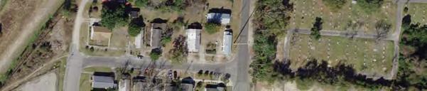


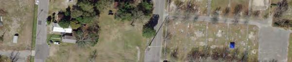


14 Harnett St Hall St Z Attachment 2 Aerial Imagery 708&812AndersonSt 909&911Hanover St 901&906FanningSt 813N10thSt Site Parcels Bladen St Post St Mcrae St N 10th St N 11th St Whistler Ave nswick St Fanning St N 8th St Anderson St Woods Ave Hanover St Feet Campbell St 11/9/2017
15 Z Attachment 3 LandUse&Zoning Harnett St O&I-1 Hall St 708&812AndersonSt 909&911Hanover St 901&906FanningSt 813N10thSt CEM Site Zoning Bladen St Single Family Multi Family Post St Utilities nswick St Mcrae St O&I-1(CD) N 10th St Fanning St N 11th St Whistler Ave Office & Institutional Commercial Park Cemetery Vacant N 8th St Anderson St R-3 Woods Ave Hanover St CB Campbell St MF-M CEM Feet 11/9/2017
16 Nixon St King St Z Attachment 4 GrowthStrategies Mcree Aly Swann St 708&812AndersonSt 909&911Hanover St 901&906FanningSt 813N10thSt Love Aly Site Harnett St Hall St Mixed-use Centers Urban Neighborhood Nodes Corridors & Complete Streets N 7th St Community Connector Peacock Ln Murphy Aly Bladen St Brunswick St N 8th St Mcrae St Hanover St Anderson St Fanning St N 10th St Post St N 11th St Whistler Ave Woods Ave Main Street Special Character Street Green Connections Planned Conceptual High-capacity Transit Routes Passenger Rail Parks Areas of Opportunity Postindustrial & Inner-city Revitalization Neighborhood-scale Infill Development Campbell St N 6th St Red Cross St Brooks Aly Rehder Aly Rankin St N 12th St N 14th St Feet body Aly N 13th St 11/9/2017


17 Z Attachment 5 Northside SAP 708 & 812 Anderson St 909 & 911 Hanover St 901 & 906 Fanning St 813 N 10th St Site Feet 11/17/2017
18
PLANNING COMMISSION. Agenda Item # 3.
 PLANNING COMMISSION Agenda Item # 3. CASE SUMMARY Conditional District Rezoning Planning Commission February 4, 2015 CD-9-215 Jeff Walton, 341-3260, jeff.walton@wilmingtonnc.gov Staff recommendation CONDITIONAL
CHAPTER 7: VISION AND ACTION STATEMENTS. Noble 2025 Vision Statement
 CHAPTER 7: VISION AND ACTION STATEMENTS This chapter presents the vision, policy and action statements that transform the comprehensive planning study, an analysis of Noble s past, future trends and community
PLANNING COMMISSION. Agenda Item # 6.
 PLANNING COMMISSION Agenda Item # 6. LAND DEVELOPMENT CODE AMENDMENT Planning Commission: October 5, 2016 Case: LDC-6-1016 Staff Contact: Eryn K. Moller; eryn.moller@wilmingtonnc.gov 910-341-4695 Staff
Planning Commission April 4, 2013 BOCC Workshop Page 1
 Planning Commission April 4, 2013 BOCC Workshop Page 1 Planning Commission April 4, 2013 BOCC Workshop Page 2 Planning Commission April 4, 2013 BOCC Workshop Page 3 Planning Commission April 4, 2013 BOCC
SUMMERSIDE / MT. CARMEL REINVESTMENT CORRIDOR COMMUNITY DEVELOPMENT STRATEGY
 SUMMERSIDE / MT. CARMEL REINVESTMENT CORRIDOR COMMUNITY DEVELOPMENT STRATEGY FEBRUARY 2013 I. Location of the Summerside/Mt. Carmel Reinvestment Corridor The Summerside/Mt. Carmel Reinvestment Corridor
EXECUTIVE SUMMARY DRAFT CHAPTER 1 INTRODUCTION EXECUTIVE SUMMARY
 CHAPTER 1 EXECUTIVE SUMMARY INTRODUCTION Through the joint efforts of the City of Tulsa planning staff and the Land Services division of Indian Nations Council of Governments (INCOG), the Berryhill Land
17.11 Establishment of Land Use Districts
 17.11 Establishment of Land Use Districts 17.11.010 Purpose. To promote the health, safety, and general welfare of City residents and those who come to South Salt Lake to work, exchange commerce and recreate.
A BLUEPRINT FOR BROCKTON A CITY-WIDE COMPREHENSIVE PLAN
 A BLUEPRINT FOR BROCKTON A CITY-WIDE COMPREHENSIVE PLAN Public Meeting October 2016 1 Plan Summary and Discussion Public Meeting May 4 2017 City of Brockton Bill Carpenter, Mayor Department of Planning
In surveys, Dallas residents say what they want to change most
 NEIGHBORHOODS ELEMENT In surveys, Dallas residents say what they want to change most in the city is its appearance they want it to look beautiful, with trees and pedestrian-friendly neighborhoods. The
PSRC REVIEW REPORT & CERTIFICATION RECOMMENDATION
 PSRC REVIEW REPORT & CERTIFICATION RECOMMENDATION KITSAP COUNTY COUNTYWIDE PLANNING POLICIES July 2, 2012 BACKGROUND A major emphasis of the Washington State Growth Management Act (GMA) is the need to
Table of Contents. Elm Avenue Improvement Plan City of Waco, Texas. Introduction 1. Existing Context 1 Figure 1 2.
 Table of Contents Introduction 1 Existing Context 1 Figure 1 2 Plan Guidelines 3 Future Urban Form 4 The West-End 4 Main Street 6 The East-End 7 Figure 2 9 Public Improvement Recommendations 7 General
COLVER ROAD INDUSTRIAL CONCEPT PLAN
 COLVER ROAD INDUSTRIAL CONCEPT PLAN A CONCEPTUAL LAND USE AND TRANSPORTATION PLAN FOR TA-4 AN URBAN RESERVE AREA OF THE CITY TALENT City of Talent Adopted by City Council Resolution No., June, 2015 PART
A. WHAT IS A GENERAL PLAN?
 I. Introduction A. WHAT IS A GENERAL PLAN? A general plan is the planning guideline for the future of a city. It contains goals and policies which regulate urban development, the protection of the natural
CHAPTER 12 IMPLEMENTATION
 CHAPTER 12 IMPLEMENTATION The 2010 Town of Denton Comprehensive Plan is intended to capture a vision of the future of Denton. As such, it provides a basis for a wide variety of public and private actions
4.1.3 LAND USE CATEGORIES
 4.1.3 LAND USE CATEGORIES a. City Center District The City Center District incorporates the existing character and mix of uses in downtown Belmont to encourage redevelopment and new development in keeping
REZONING GUIDE. Zone Map Amendment (Rezoning) - Application. Rezoning Application Page 1 of 3. Return completed form to
 - Application. Rezoning Application Page 1 of 3. Return completed form to") Zone Map Amendment (Rezoning) - Application COMMUNITY PLANNING & DEVELOPMENT REZONING GUIDE Rezoning Application Page 1 of 3 PROPERTY OWNER INFORMATION* CHECK IF POINT OF CONTACT FOR APPLICATION Property
Zone Map Amendment (Rezoning) - Application COMMUNITY PLANNING & DEVELOPMENT REZONING GUIDE Rezoning Application Page 1 of 3 PROPERTY OWNER INFORMATION* CHECK IF POINT OF CONTACT FOR APPLICATION Property
Implementation Guide Comprehensive Plan City of Allen
 Implementation Guide 2030 Comprehensive Plan City of Allen DRAFT 2015 Implementation Guide Allen 2030 Comprehensive Plan INTRODUCTION The Comprehensive Plan serves as a guide for the growth and development
CHAPTER 3 VISION, GOALS, & PLANNING PRINCIPLES. City of Greensburg Comprehensive Plan. Introduction. Vision Statement. Growth Management Goals.
 CHAPTER 3 VISION, GOALS, & PLANNING PRINCIPLES Introduction The Greensburg Comprehensive Plan is intended as a working community document. A combination of long and short-term goals, this document is intended
Plano Tomorrow Vision and Policies
 Plano Tomorrow Vision and Policies PLANO TOMORROW PILLARS The Built Environment The Social Environment The Natural Environment The Economic Environment Land Use and Urban Design Transportation Housing
Staff Report and Recommendation
 Community Planning and Development Planning Services 201 W. Colfax Ave., Dept. 205 Denver, CO 80202 p: 720.865.2915 f: 720.865.3052 www.denvergov.org/cpd TO: City Council Neighborhoods and Planning Committee
North Fair Oaks Community Plan Summary and Information
 North Fair Oaks Community Plan Summary and Information WHAT IS THE NORTH FAIR OAKS COMMUNITY PLAN? The North Fair Oaks Community Plan is part of the San Mateo County General Plan, and establishes policies
Land Use Amendment in Southwood (Ward 11) at and Elbow Drive SW, LOC
 at and Elbow Drive SW, LOC") 2018 November 15 Page 1 of 10 EXECUTIVE SUMMARY This land use amendment application was submitted by Rick Balbi Architect on 2017 August 31 on behalf of Sable Developments Ltd, and with authorization from
2018 November 15 Page 1 of 10 EXECUTIVE SUMMARY This land use amendment application was submitted by Rick Balbi Architect on 2017 August 31 on behalf of Sable Developments Ltd, and with authorization from
CITY OF PUYALLUP. Background. Development Services
 CITY OF PUYALLUP Development Services 333 South Meridian Puyallup WA 98371 To: City Council From: Katie Baker, AICP, Planning Division Re: South Hill Neighborhood Plan Adoption Date: (Meeting date: February
Planning Districts INTRODUCTION
 INTRODUCTION To facilitate detailed examination of development prospects for all areas of the community, Delano has been divided into 14 planning districts. The location of these planning districts is
Planned Residential Neighborhoods Land Use Goals
 Planned Residential Neighborhoods Land Use Goals Issue: Guidelines that provide for diverse high quality residential areas that include a variety of housing styles and layouts are needed. Goal 1: Create
PLANNING COMMISSION. Agenda Item # 4.
 PLANNING COMMISSION Agenda Item # 4. LDC-6-118 - LAND DEVELOPMENT CODE AMENDMENT City Council January 3, 2018 LDC-6-118 Ron Satterfield, Assistant Planning Director 910-341-3255 ron.satterfield@wilmingtonnc.gov
LAND USE OVERVIEW WHAT YOU WILL FIND IN THIS CHAPTER
 LAND USE WHAT YOU WILL FIND IN THIS CHAPTER Information about the City s expected population and employment growth. Description and capacity of existing and future land use designations. Policies that
AWH REPORT OF THE PLANNING AND DEVELOPMENT DEPARTMENT FOR APPLICATION FOR REZONING ORDINANCE TO PLANNED UNIT DEVELOPMENT
 AWH REPORT OF THE PLANNING AND DEVELOPMENT DEPARTMENT FOR APPLICATION FOR REZONING ORDINANCE TO PLANNED UNIT DEVELOPMENT MAY 8, 2014 The Planning and Development Department hereby forwards to the Planning
NEW CASTLE COUNTY S ZONING DISTRICTS
 NEW CASTLE COUNTY S ZONING DISTRICTS This is general information about New Castle County s zoning districts. The information included is by no means exhaustive or complete. Before designing plans to develop
Citizen Comment Staff Response Staff Recommended Revision Planning Committee
 Citizen Comment Staff Response Staff Recommended Revision Planning Committee Area No. 1: Owner desires retail land uses. Area No. 1a: Owner of two small parcels adjacent to Area No. 1 desires retail land
Chapter 4. Linking Land Use with Transportation. Chapter 4
 Chapter 4 Linking Land Use with Transportation Chapter 4 59 Chapter 4 Linking Land Use with Transportation Community Design and Transportation Program Introduction Since the 1950s, the predominant development
38 Queen s University Campus Master Plan Part 1
 38 Queen s University Campus Master Plan Part 1 46 The Campus at the City Scale Chapter 4 The Campus at the City Scale 39 Queen s is an urban University centrally located in Kingston. Decisions made by
Table L-1 Summary Action Strategy. Action Item Timing Status Responsible Agency
 CHAPTER 4: CIRCULATION ELEMENT ISSUE #1: MAJOR THOROUFARES AND TRANSPORTATION ROUTES A balanced transportation system for Fontana is provided that meets the mobility needs of current and future residents
The West Vaughan Employment Area Secondary Plan Policies
 Part 2: The West Vaughan Employment Area Secondary Plan Policies 2.1 General Policies It is the policy of Council: 2.1.1. That the West Vaughan Employment Area (the WVEA), identified on Schedule 1, will
Concord Community Reuse Project Goals and Guiding Principles. Overarching Goals (OG)
") Concord Community Reuse Project Goals and Guiding Principles Overarching Goals (OG) No priority is implied by the order of presentation of the goals and guiding principles. Overarching goals for the Concord
Concord Community Reuse Project Goals and Guiding Principles Overarching Goals (OG) No priority is implied by the order of presentation of the goals and guiding principles. Overarching goals for the Concord
Edward R. Sajecki Commissioner of Planning and Building
 Corporate Report Clerk s Files Originator s Files CD.03.POR DATE: TO: FROM: SUBJECT: Chair and Members of Planning and Development Committee Meeting Date: February 27, 2012 Edward R. Sajecki Commissioner
SECTION E. Realizing the Plan
 SECTION E Realizing the Plan 60 DESIGN REGINA - OFFICIAL COMMUNITY PLAN SECTION E Realizing the Plan Design Regina has been an ambitious plan-making exercise, with a high level of community, stakeholder,
COMMUNITY DESIGN. GOAL: Create livable and attractive communities. Intent
 COMMUNITY DESIGN Intent An attractive, well-designed County will attract quality development, instill civic pride, improve the visual character of the community, and create a strong, positive image for
ARLINGTON COUNTY, VIRGINIA
 ARLINGTON COUNTY, VIRGINIA County Board Agenda Item Meeting October 15, 2005 DATE: September 28, 2005 SUBJECT: Request to Advertise the adoption of the 2005 Clarendon Sector Plan C. M. RECOMMENDATION:
DRAFT Amsterdam/Churchill Community Plan (4/17/08) Adopted By the Gallatin County Commission
 Adopted By the Gallatin County Commission") DRAFT Amsterdam/Churchill Community Plan (4/17/08) Adopted By the Gallatin County Commission Table of Contents Acknowledgements Chapter 1: Introduction A Brief History What s Next Authority Organization
DRAFT Amsterdam/Churchill Community Plan (4/17/08) Adopted By the Gallatin County Commission Table of Contents Acknowledgements Chapter 1: Introduction A Brief History What s Next Authority Organization
Planning & Zoning Commission Staff Report
 Planning & Zoning Commission Staff Report Meeting Date: May 26, 2015 Drafted by: Katherine Harrison-Rogers CASE # Z2886 PROJECT NAME: APPLICANT/ REPRESENTATIVE: Shawna Runyan PROPERTY OWNER: 1840 (previously
VILLAGE OF CLEMMONS PLANNING BOARD DRAFT STAFF REPORT
 VILLAGE OF CLEMMONS PLANNING BOARD DRAFT STAFF REPORT PETITION INFORMATION Docket # C-226 Staff Megan Ledbetter Petitioner(s) JBJH Properties, LLC Owner(s) JBJH Properties, LLC Subject Property 5892-49-1766
Hockessin Community Redevelopment Plan
 Hockessin Community Redevelopment Plan 3.1 Introduction The Community Redevelopment Plan for the Village of Hockessin is the result of the people s vision for a distinct village center that serves as the
Planned Development Review Revisions (Project No. PLNPCM )
") Planned Development Review Revisions (Project No. PLNPCM2014-00139) Standard residential development Planned Development Example: Smaller lot sizes than what is allowed to create open space amenity. What
Planned Development Review Revisions (Project No. PLNPCM2014-00139) Standard residential development Planned Development Example: Smaller lot sizes than what is allowed to create open space amenity. What
CITY OF LANGLEY OFFICIAL COMMUNITY PLAN BYLAW, 2005, NO APPENDIX II - REGIONAL CONTEXT MAP
 CITY OF LANGLEY OFFICIAL COMMUNITY PLAN BYLAW, 2005, NO. 2600 APPENDIX II - REGIONAL CONTEXT MAP ± Legend Agricultural Mixed Employment Industrial Conservation & Recreation Regional City Centre Urban Containment
Rapid City Planning Commission Comprehensive Plan Amendment Project Report
 Rapid City Planning Commission Comprehensive Plan Amendment Project Report June 7, 2018 Applicant Request(s) Item #3 Case # 18CA001 Comprehensive Plan Amendment to change the future land use from Mixed-
TRANSPORTATION ELEMENT GOALS, OBJECTIVES, AND POLICIES
 TRANSPORTATION ELEMENT GOALS, OBJECTIVES, AND POLICIES GOAL 2 The City shall provide a safe, convenient, effective, and energy efficient multimodal transportation system which is coordinated with the Future
EXISTING COMPREHENSIVE PLAN
 EXISTING COMPREHENSIVE PLAN Town Center Land Use Element: V. LAND USE POLICIES Town Center Mercer Island's business district vision as described in "Your Mercer Island Citizen-Designed Downtown" was an
QUEEN-RIVER SECONDARY PLAN
 34 QUEEN-RIVER SECONDARY PLAN 34. QUEEN RIVER SECONDARY PLAN 1. INTRODUCTION The Queen-River area is approximately 6.4 hectares and is located at the eastern edge of the Downtown as shown on Map 34-1.
RECREATION AND OPEN SPACE ELEMENT GOALS, OBJECTIVES, AND POLICIES
 RECREATION AND OPEN SPACE ELEMENT GOALS, OBJECTIVES, AND POLICIES Goal 7 To provide park facilities, recreation programs, and open space resources that are safe, adequate, and accessible to all City residents,
Conditional District Rezoning
 CASE SUMMARY Conditional District Rezoning Planning Commission October 5, 2016 CD-7-1016 Brian Chambers, 910-342-2782, brian.chambers@wilmingtonnc.gov Staff recommendation Planning Commission Recommendation
ALBEMARLE COUNTY CODE CHAPTER 18 ZONING SECTION 20A NEIGHBORHOOD MODEL - NMD
 CHAPTER 18 ZONING SECTION 20A NEIGHBORHOOD MODEL - NMD Sections: 20A.1 PURPOSE AND INTENT 20A.2 STATUS AS A PLANNED DEVELOPMENT DISTRICT 20A.5 CODES OF DEVELOPMENT 20A.6 PERMITTED USES 20A.7 RESIDENTIAL
C. Westerly Creek Village & The Montview Corridor
 C. Westerly Creek Village & The VISION Community Vision When the goals of the city are achieved Westerly Creek Village, a distinctive community defined by Montview Boulevard and Westerly Creek, is a strong
WHEREAS, the current Comprehensive Plan was adopted in 2005; and
 RESOLUTION 2018-06 RESOLUTION TO AMEND THE CITY S COMPREHENSIVE PLAN TO (1) AMEND CHAPTER 4 TO ADD A SPECIAL REVITALIZATION DISTRICT FOR EDUCATION AND ECONOMIC DEVELOPMENT ; (2) DESIGNATE ON THE FUTURE
QUINCE ORCHARD/FIRSTFIELD CORRIDOR CITY OF GAITHERSBURG MTAP 2017
 QUINCE ORCHARD/FIRSTFIELD CORRIDOR CITY OF GAITHERSBURG MTAP 2017 ULI LEADERSHIP INSTITUTE 2017 The Team Allison Davis, WMATA Daniel Park, Rodgers Consulting Debbie Albert, Arlington County Harry Ross,
Volume 2: Implementation Plan
 Volume 2: Implementation Plan February 25 th 2002 Implementation Introduction This document outlines the steps that should be taken to implement the Washington Heights Neighborhood Plan. The City Council
CITY OF COLWICH COMPREHENSIVE PLAN LAND USE LAND USE 1
 LAND USE LAND USE 1 WHAT YOU WILL FIND IN THIS CHAPTER: Discussion of today s conditions and tomorrow s projections Discussion of challenges and opportunities Discussion of the environmental quality goals,
Urban Design Brief. Watson Parkway North & Watson Road North Guelph, Ontario. Prepared by Coletara Development
 Urban Design Brief Watson Parkway North & Watson Road North Guelph, Ontario Prepared by Coletara Development December, 2013 Urban Design Brief, Coletara Development 1 Introduction This Urban Design Brief
Joint Meeting City Council and the Plan Commission. September 1st, 2015
 Joint Meeting City Council and the Plan Commission September 1st, 2015 1 The City Plan Commission shall recommend a City Plan for the physical development of the City Article IX Section 2 of the City of
FINAL WEST OAKLAND SPECIFIC PLAN & FINAL ENVIRONMENTAL IMPACT REPORT
 1 FINAL WEST OAKLAND SPECIFIC PLAN & FINAL ENVIRONMENTAL IMPACT REPORT Landmarks Preservation Advisory Board Public Hearing June 9, 2014 2 Purpose of LPAB public hearing Provide cultural-resource related
Living in Albemarle County s Urban Places
 Living in Albemarle County s Urban Places ALBEMARLE COUNTY, VIRGINIA A Closer Look at Albemarle s Approach to Managing Growth and Creating Quality Urban Environments www.albemarle.org Page 2 Living in
TO: Denver Planning Board FROM: Analiese Hock, Senior City Planner DATE: March 13, 2018 RE:
 Community Planning and Development Planning Services 201 W. Colfax Ave., Dept. 205 Denver, CO 80202 p: 720.865.2915 f: 720.865.3052 www.denvergov.org/cpd TO: Denver Planning Board FROM: Analiese Hock,
Cumberland Region Tomorrow is a private, non-profit, citizen based regional organization working with Greater Nashville Regional Council
 Cumberland Region Tomorrow is a private, non-profit, citizen based regional organization working with Greater Nashville Regional Council and others in the public and private sectors, dedicated to planning
TOD 101 CREATING LIVABLE COMMUNITIES WITH TRANSIT
 1 CREATING LIVABLE COMMUNITIES WITH TRANSIT What are transit Centered Communities? Benefits of Partnerships to Support and Implement What You Will Learn Portland s Pearl District Your Trainers Today Catherine
SPRINGHILL LAKE TRANSIT VILLAGE
 Greenbelt Metro Area Sector Plan - Subarea Design Policies and Guidelines - Springhill Lake Transit Village 113 SPRINGHILL LAKE TRANSIT VILLAGE Residential Neighborhood and Village Center CONCEPT Springhill
Staff Report to the North Ogden City Planning Commission
 Staff Report to the North Ogden City Planning Commission SYNOPSIS / APPLICATION INFORMATION Application Request: Concept review on a legislative application to rezone land located at approximately 1750
Urban Design Manual PLANNING AROUND RAPID TRANSIT STATIONS (PARTS) Introduction. Station Study Areas
 Introduction. Station Study Areas") 111111 PLANNING AROUND RAPID TRANSIT STATIONS (PARTS) Introduction The ION rapid transit system will link Waterloo, Kitchener and Cambridge through a central transit corridor (CTC). There are a number
111111 PLANNING AROUND RAPID TRANSIT STATIONS (PARTS) Introduction The ION rapid transit system will link Waterloo, Kitchener and Cambridge through a central transit corridor (CTC). There are a number
Existing Conditions Summary (Draft for Review)
") Existing Conditions Summary (Draft for Review) Prepared by March 16, 2015 Bird s-eye-view of Norwalk in 1899 (Cropped) Existing Conditions Summary (Draft for Review) March 16, 2015 Table of Contents 1.
Existing Conditions Summary (Draft for Review) Prepared by March 16, 2015 Bird s-eye-view of Norwalk in 1899 (Cropped) Existing Conditions Summary (Draft for Review) March 16, 2015 Table of Contents 1.
City Of Sparks Planning Commission Item
 Page 1 of 12 City Of Sparks Planning Commission Item Meeting Date: May17, 2012 Subject: PCN12009, Public Hearing, Consideration and possible action on a Master Plan Amendment and Rezoning request to change
Plan-It Greenville (2009) Comprehensive Plan 5-Year Update
 Comprehensive Plan 5-Year Update") Plan-It Greenville (2009) Comprehensive Plan 5-Year Update What is the comprehensive plan: Collecting communitywide data Projecting future population growth Setting communitywide goals Framing policies
Plan-It Greenville (2009) Comprehensive Plan 5-Year Update What is the comprehensive plan: Collecting communitywide data Projecting future population growth Setting communitywide goals Framing policies
CHAPTER 7: Transportation, Mobility and Circulation
 AGLE AREA COMMUNITY Plan CHAPTER 7 CHAPTER 7: Transportation, Mobility and Circulation Transportation, Mobility and Circulation The purpose of the Transportation, Mobility and Circulation Chapter is to
, C-MS I June 3, 2016 $1500 pd chk #216918
 , C-MS-8 LOTS 21 THROUGH 40, INCLUSIVE, BLOCK 299 CLEMENTS ADDITION TO THE CITY OF DENVER SOUTHEAST QUARTER OF SECTION 34, TOWNSHIP 3 SOUTH, RANGE 68 WEST, SIXTH PRINCIPAL MERIDIAN, CITY
THAT the attached Terms of Reference for the Thornhill Centre Street Study be approved.
 COMMITTEE OF THE WHOLE AUGUST 18, 2003 THORNHILL CENTRE STREET STUDY PLANNING FILE: 15.92 Recommendation The Commissioner of Planning recommends: THAT the attached Terms of Reference for the Thornhill
STAFF SUMMARY FOR S17-02 SPECIAL USE PERMIT APPLICATION
 APPLICATION SUMMARY Case Number: S17-02 Request: STAFF SUMMARY FOR S17-02 SPECIAL USE PERMIT APPLICATION SUP application in order to develop a convenience food store. Applicant: Property Owner(s): Cindee
CAMPUS MASTER PLAN, AMENDMENTS
 CAMPUS MASTER PLAN AMENDMENTS CAMPUS MASTER PLAN, 2015-2025 AMENDMENTS OCTOBER 2016 PLANNING, DESIGN & CONSTRUCTION DIVISION AMENDMENTS UNIVERSITY OF FLORIDA COMPREHENSIVE MASTER PLAN OCTOBER 2016 1. Acreage
Sewanee Village + Request for Builder/Developer Proposals
 Sewanee Village + Request for Builder/Developer Proposals Contact: Frank X. Gladu Special Assistant to the Vice Chancellor University of the South 735 University Ave Version 3 Sewanee TN 37383 Released:
Ivywild On The Creek PRELIMINARY CREEK DISTRICT MASTER PLAN
 Ivywild On The Creek PRELIMINARY CREEK DISTRICT MASTER PLAN Introduction: Rejuvenating an extraordinary Creekside neighborhood THE CREEKSIDE DISTRICT The Ivywild On The Creek Neighborhood District Master
BUDGETING FOR OUTCOMES TRINITY RIVER CORRIDOR
 BUDGETING FOR OUTCOMES TRINITY RIVER CORRIDOR Trinity River Corridor Team Members: Kelly High, Streets Department Megan Lam, Office of Financial Services Mike Mikeska, Dallas Water Utilities Diana Ochoa,
A Growing Community Rural Settlement Areas
 Town of Huntsville Official Plan Review - POLICY BACKGROUND PAPER A Growing Community Rural Settlement Areas BACKGROUND: In addition to the fully municipally-serviced Urban Settlement Area and the Hidden
TO: Mayor & Council DATE: April 12, The Planning and Development Department and the Engineering Department recommend that Council:
 CORPORATE REPORT NO: R080 COUNCIL DATE: April 12, 2010 REGULAR COUNCIL TO: Mayor & Council DATE: April 12, 2010 FROM: SUBJECT: General Manager, Planning and Development General Manager, Engineering Neighbourhood
DRAFT Subject to Modifications
 TREASURE COAST REGIONAL PLANNING COUNCIL M E M O R A N D U M To: Council Members AGENDA ITEM 8 From: Date: Subject: Staff May 19, 2017 Council Meeting Florida Department of Transportation Complete Streets
POLICY AMENDMENT AND LAND USE AMENDMENT KILLARNEY/GLENGARRY (WARD 8) NW CORNER OF RICHMOND ROAD AND 33 STREET SW BYLAWS 1P2015 AND 7D2015
 NW CORNER OF RICHMOND ROAD AND 33 STREET SW BYLAWS 1P2015 AND 7D2015") Page 1 of 13 EXECUTIVE SUMMARY This application seeks to redesignate an RC-2 (Residential Contextual One/Two Dwelling) parcel to MC-Gd72 (Multi-Residential Contextual Grade-Oriented) to allow for multi-residential
Page 1 of 13 EXECUTIVE SUMMARY This application seeks to redesignate an RC-2 (Residential Contextual One/Two Dwelling) parcel to MC-Gd72 (Multi-Residential Contextual Grade-Oriented) to allow for multi-residential
PLANNING COMMISSION. Agenda Item # 3
 PLANNING COMMISSION Agenda Item # 3 CASE SUMMARY Special Use Permit MEETING: Planning Commission, October 6, 2010 CASE NO: SITE ADDRESS: PROPOSAL: PRESENTED BY: STAFF RECOMMENDATION: SU-4-1010 406 S. 21st
The transportation system in a community is an
 7 TRANSPORTATION The transportation system in a community is an important factor contributing to the quality of life of the residents. Without a sound transportation system to bring both goods and patrons
Arlington, Virginia is a worldclass
 EXECUTIVE S U M M A RY Arlington maintains a rich variety of stable neighborhoods, quality schools and enlightened land use policies, and received the Environmental Protection Agency s highest award for
WEST OAKLAND SPECIFIC PLAN & DRAFT ENVIRONMENTAL IMPACT REPORT
 WEST OAKLAND SPECIFIC PLAN & DRAFT ENVIRONMENTAL IMPACT REPORT Landmarks Preservation Advisory Board Public Hearing February 10, 2014 1 Specific Plan Overview Plan Area is generally bounded by I-580 to
Mark-up of the effect of the proposed Bronte Village Growth Area OPA No.18 on the text of section 24, Bronte Village, of the Livable Oakville Plan
 Mark-up of the effect of the proposed Bronte Village Growth Area OPA No.18 on the text of section 24, Bronte Village, of the Livable Oakville Plan Notes: This document is provided for information purposes
International Blvd. TOD Plan Public Workshop #1
 International Blvd. TOD Plan Public Workshop #1 Add photos or project images September 21 and 22, 2010 Workshop Purpose Introduce the public to the Project Review and discuss the existing conditions analysis
IMPLEMENTING SOMERSET COUNTY S INVESTMENT FRAMEWORK
 IMPLEMENTING SOMERSET COUNTY S INVESTMENT FRAMEWORK SMART CONSERVATION THROUGH SMART GROWTH NJ LAND CONSERVATION RALLY March 22, 2014 Laurette Kratina, PP, AICP, Supervising Planner Somerset County Planning
ESTABLISH AN EFFICIENT TOWN CENTER
 ESTABLISH AN EFFICIENT TOWN CENTER 4 Overview Lisbon residents are proud of the history of Newent and at the same time recognize its current importance as a centralized location for a variety of municipal
Rezoning Petition Pre-Hearing Staff Analysis April 16, 2018
 Rezoning Petition 2018-015 Pre-Hearing Staff Analysis April 16, 2018 REQUEST LOCATION Current Zoning: R-4 (single family residential) and UR-2(CD) (urban residential, conditional) Proposed Zoning: UR-2(CD)
Economic Development & Housing Council Committee Comprehensive Plan Update September 20, 2005
 1 Economic Development & Housing Council Committee Comprehensive Plan Update September 20, 2005 Purpose To update the Committee on the ForwardDallas! Plan, including: Status Anticipated Products Public
EXHIBIT A. Tax Increment Reinvestment Zone No. 1 (Town Center) First Amended Project Plan 1
 First Amended Project Plan 1") EXHIBIT A Tax Increment Reinvestment Zone No. 1 (Town Center) First Amended Project Plan 1 1 As amended by Resolution No. 2008-02-001(TR1R) of the Tax Increment Reinvestment Zone No.1, and approved to
EXHIBIT A Tax Increment Reinvestment Zone No. 1 (Town Center) First Amended Project Plan 1 1 As amended by Resolution No. 2008-02-001(TR1R) of the Tax Increment Reinvestment Zone No.1, and approved to
RESOLUTION NO. R Refining the route, profile and stations for the Downtown Redmond Link Extension
 RESOLUTION NO. R2018-32 Refining the route, profile and stations for the Downtown Redmond Link Extension MEETING: DATE: TYPE OF ACTION: STAFF CONTACT: Capital Committee Board PROPOSED ACTION 09/13/2018
Chapter 10 IMPLEMENTATION RECOMMENDATIONS
 Chapter 10 IMPLEMENTATION RECOMMENDATIONS The recommended land use plan presented in the previous chapter provides a design for the attainment of the urban and rural development and open space preservation
Blueprint Denver A BLUEPRINT FOR AN INCLUSIVE CITY. Executive Summary
 Blueprint Denver A BLUEPRINT FOR AN INCLUSIVE CITY Executive Summary PUBLIC REVIEW DRAFT 2 1/7/2019 DENVERIGHT BLUEPRINTDENVER Blueprint Denver: A Blueprint for an Inclusive City An Equitable City Planning
3.10 LAND USE SETTING PROJECT SITE EXISTING LAND USE DESIGNATIONS AND ZONING. General Plan Land Use Designations.
 This section of the Draft EIR addresses the existing land uses on and adjacent to the project site and discusses the potential impacts of the proposed project on existing land uses. Key issues addressed
DOWNTOWN CHAPEL HILL SMALL AREA PLAN
 DOWNTOWN CHAPEL HILL SMALL AREA PLAN A Component of the Chapel Hill Comprehensive Plan With DOWNTOWN DESIGN GUIDELINES Adopted March 27, 2000 TABLE OF CONTENTS SECTION PAGE 1. Vision Statement.. 5 2. Goals
Former Rockcliffe Airbase Community Design Plan Guiding Design Vision and Principles December 4, 2013
 APPENDIX 5 - Guiding Design Vision and Principles Former Rockcliffe Airbase Community Design Plan Guiding Design Vision and Principles December 4, 2013 Vision Statement The redevelopment of the former
Allen Street Civic District Redevelopment Area Plan Redevelopment Plan & Proposal State College Planning Commission State College Redevelopment
 Allen Street Civic District Redevelopment Area Plan Redevelopment Plan & Proposal State College Planning Commission State College Redevelopment Authority September 17, 2015 Discussion Points Overview of