Toward a Robust Flood Emergency Evacuation Integration of 2-D Hydraulic Modeling and Dynamic Evacuation Routing
|
|
|
- Ashlyn Atkins
- 5 years ago
- Views:
Transcription
1 Toward a Robust Flood Emergency Evacuation Integration of 2-D Hydraulic Modeling and Dynamic Evacuation Routing Esri User Conference 2016 Sheng Tan, GISP June 29, 2016
2 Presentation Overview Study purpose Case study location Methodology Evacuation modeling elements Assessment results Future applications
3 Study Purpose / Background Undertake a pilot flood evacuation study The goal of the study is to develop a decision support tool for emergency managers The tool considers the time-varying hazard resulting from the propagation of a flood during an evacuation This dynamic consideration of the hazard definition is a new addition to the science of Emergency Management planning for flooding

4 Pilot Study Location Natomas Basin Development in deep floodplain Well-defined physical boundaries 100,000 residents Critical infrastructure Increased risk from future development
5 Methodology High-resolution 2D hydraulic flood modeling Vehicular evacuation modeling Both models currently exist independent of one another Wood Rodgers has developed a methodology to link both types of models Linked modeling enables the dynamic assessment of an evacuating population, accounting for the progression of a flood hazard during an event
6 Evacuation Input Data Requirements Evacuation Hazards H&H Model Output Evacuation Network Street Dataset Evacuation Candidates Endangered Population Evacuation Destinations Safety Zones


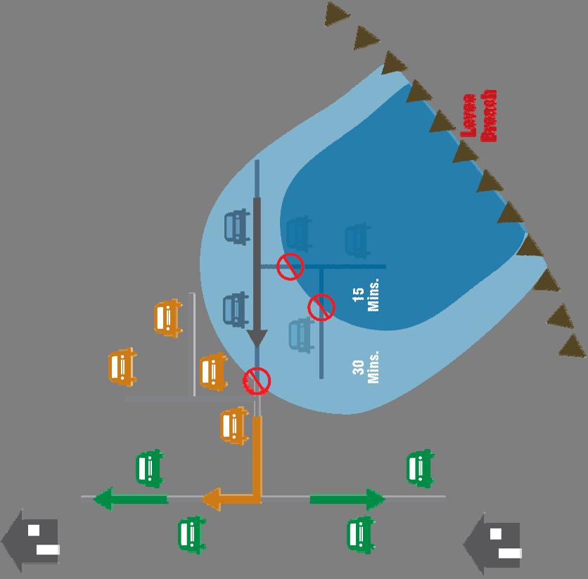

7 Evacuation Process During Flood Propagation

8 Evacuation Model Design


9 Hydraulic Model Requirements for Emergency Response High resolution is necessary to adequately characterize flood propagation in the floodplain Temporal variations in inundation extent, depth and velocity

10 Evacuation Network City of Sacramento Data Does not have all attributes Free Data TIGER Open StreetMap Connectivity Issues Incomplete Attributes
11 Evacuation Network Esri Streetmap Premium Read Only Third Party Vendors NAVTEQ HERE TomTom MultiNET Good connectivity Good attributes

12 Evacuation Candidates Based on Census Block Data Distribute by Parcel and Land Use Determine Population and its Location

13 Evacuation Destination Safe Zones based on City of Sacramento Emergency Action Plan
14 Definition of Terms Traffic Modeling Measures the Rate and Capacity of Traffic Flow Closest Facility Solution Measures the Cost of Traveling Between Incidents (People) and Facilities (Safe Zones) and Determines which are Nearest to One Another
15 Assess Evacuation Planning Systems Transportation Modeling with SACOG Model Using Cube Voyager Forecasting Model Based on Travel Demand of Population Includes Traffic Model No Closets Facility Solution GIS Based Network Model Using ArcGIS Feasible Based on Review of Existing Literature No Traffic Model Includes Closest Facility Solution ArcCASPER Capacity Aware Shortest Path Evacuation Routing Includes Traffic Model Includes Closest Facility Solution
16 ArcCASPER Developed by Kaveh Shahabi, University of Southern California Purpose: Minimize Evacuation Time GIS Based Requires ArcGIS Network Analyst Extension Free Proprietary Software Available for Commercial and Non-commercial Use Tested in Urban-Scale Evacuation (Southern California)
17 ArcCASPER
18 Evacuation Modeling An effective evacuation model will need the following criteria: The capacity of the road network is considered The traffic model is integrated to simulate traffic congestion ArcCASPER (Capacity-Aware Shortest Path Evacuation Route) meets both criteria ArcCASPER solves for routes with the shortest evacuation time


19 ArcCASPER Verification 1. The Network Analyst Closest Facility Solution No allowance for congestion 10min evacuation of Natomas Flow rate > 19,000 (v/l/h) 2. Arc CASPER Closest Facility Solution Allowance for congestion 54 min evacuation of Natomas Flow rate 1,600 (v/l/h)
 Time required to evacuate population")
 21,388 vehicles safely")
20 Pilot Study Assessment Results Pilot study population = 22,612 vehicles (portion of Natomas) Time required to evacuate population = 54 minutes 1,216 vehicles flooded (before and during evacuation) 8 vehicles stranded (though not flooded) 21,388 vehicles safely evacuate

21 Pilot Study Assessment Results
22 Pilot Study Assessment Results Evacuation center (safe zone) results
23 Future Applications (General) Useful tool for planning studies Assessment significantly increases certainty in evacuation time predictions This information be used to improve planning associated with all elements of the evacuation planning process to achieve a successful evacuation Hazard prediction time (P) Resource mobilization time (M) Evacuation warning time (W) Community acceptance / risk education (Wf) Vehicle movement during an event (Vt)
24 Timeline Failed Evacuation Time = 0 t0 First sign of flood Prediction Calculation P Start response tr tp Estimate of flood severity Decide Strategy & Mobilize Resources M tw Start warning Community Acceptance Response Factor Wf Actual Available Time Ea Total Time Needed for Evacuation Time Needed to Warn All Dwellings W te Start evacuation traffic/ movement Low point in route cut by floodwater En Time Time Needed for Vehicle Movement Vt ti Evacuation interrupted before completion Time Lost L Rescue Phase R
25 Timeline Successful Evacuation Start response tr Raised route cut by floodwater Time = 0 Prediction Calculation P Decide Strategy & Mobilize Resources M Total Time Needed for Evacuation En Time Time Needed for Vehicle Movement Vt Community Acceptance Response Factor Wf Safety Factor if Available S Time Needed to Warn All Dwellings W t0 First sign of flood tp Estimate of flood severity tw Start warning te Start evacuation traffic/ movement ts Target safety time for design of improved system
26 Future Application (Jurisdiction Examples) Useful for emergency response personnel to plan and guide large-scale evacuations Helpful for local authorities to decide when to call for a mandatory evacuation to save life and property Can be used by DWR Flood Operations Center staff to advise local authorities of probable risks Evacuation results can be used as a community education tool, enhancing the DWR Flood Risk Notification Program
27 Questions? Sheng Tan, GISP
ArcGIS Online at Philadelphia Water Department
 ArcGIS Online at Philadelphia Water Department ESRI Public Sector Conference December 2017 Jessica Gould, GISP Megan Clarkin, AICP, LEED Green Associate Tim Smith We provide the City with integrated water,
Tracking spatiotemporal patterns of building vulnerabilities and evacuations during flood hazards
 Tracking spatiotemporal patterns of building vulnerabilities and evacuations during flood hazards Shane Hubbard Junchuan Fan Kathleen Stewart Emily White The University of Wisconsin Madison, SSEC/CIMSS
Indoor Location, Tracking, and Routing
 2013 Esri International User Conference July 8 12, 2013 San Diego, California Technical Workshop Indoor Location, Tracking, and Routing Wolfgang Hall, Esri Tobias Donaubauer, Infsoft Robert Garrity, Esri
FIREFIGHTER II: FIRE DEPARTMENT COMMUNICATIONS COMMUNICATIONS: SKILL SHEET #2 Define and Demonstrate Fire Department Radio Procedure
 NFPA 1001: 6.2.2 FIREFIGHTER II: FIRE DEPARTMENT COMMUNICATIONS COMMUNICATIONS: SKILL SHEET #2 Define and Demonstrate Fire Department Radio Procedure OBJECTIVE Trainee shall define and demonstrate prescribed
Roles, Responsibilities, and Plans for Transportation Systems in Mass Evacuations
 Roles, Responsibilities, and Plans for Transportation Systems in Mass Evacuations Brian Wolshon, Ph.D., P.E. Dept. of Civil and Env.. Engineering Gulf Coast Research Center for Evacuation and Transportation
API MANUAL OF PETROLEUM MEASUREMENT STANDARDS
 API MANUAL OF PETROLEUM MEASUREMENT STANDARDS Chapter 22 Testing Protocols Section 1 General Guidelines for Developing Testing Protocols for Devices Used in the Measurement of Hydrocarbon Fluids Type Testing
Lower Don River West Remedial Flood Protection Project TABLE OF CONTENTS. Page. Executive Summary
 TABLE OF CONTENTS Page Executive Summary 1.0 INTRODUCTION...1-1 1.1 Purpose of the Undertaking...1-1 1.2 Study Area Description...1-1 1.3 Description of the Undertaking...1-1 1.4 Rationale for the Undertaking...1-2
Resolution XII NOTING also that with the increasingly rapid urbanization, wetlands are being threatened in two principle ways:
 12 th Meeting of the Conference of the Parties to the Convention on Wetlands (Ramsar, Iran, 1971) Punta del Este, Uruguay, 1-9 June 2015 Resolution XII.10 Wetland City 1 Accreditation of the Ramsar Convention
CLARIFYING EVACUATION OPTIONS THROUGH FIRE BEHAVIOR AND TRAFFIC MODELING
 CLARIFYING EVACUATION OPTIONS THROUGH FIRE BEHAVIOR AND TRAFFIC MODELING Carol L. Rice Wildland Resource Management, Inc. carollrice@aol.com Ronny J. Coleman FireForce One Mike Price Entrada/San Juan Inc.
Draft Resolution XII.10
 12 th Meeting of the Conference of the Parties to the Convention on Wetlands (Ramsar, Iran, 1971) Punta del Este, Uruguay, 1-9 June 2015 Ramsar COP12 DR10, Rev. 2 21:45, 8 June Draft Resolution XII.10
Eastern Band of Cherokee Indians Integrated Geographical Information System (IGIS)
") Eastern Band of Cherokee Indians Integrated Geographical Information System (IGIS) 1 Background The Eastern Band of Cherokee Indians (EBCI) is the only federally recognized Tribe in North Carolina. Historically
Eastern Band of Cherokee Indians Integrated Geographical Information System (IGIS) 1 Background The Eastern Band of Cherokee Indians (EBCI) is the only federally recognized Tribe in North Carolina. Historically
Evacuation planning is a key component of
 Transportation Security Training and Education Evacuation Planning, Human Factors, and Traffic Engineering Developing Systems for Training and Effective Response REUBEN B. G OLDBLATT AND KEVIN WEINIS CH
City of Norfolk Coastal Flood Mitigation Program. March 13, 2013
 City of Norfolk Coastal Flood Mitigation Program March 13, 2013 Topics Brief overview of Norfolk s Coastal Flood Program Data-driven analysis and decision making City-wide vulnerability, project concepts,
Alarm Management Services
 Alarm Management Services Know and improve alarm performance Integrate compeletely with almost any control system Increase operator efficiency Comply with regulatory and industry standards The Value of
EVACUATION MODELING DEPENDENCE ON INPUT PARAMETERS
 PROCEEDINGS, Fire and Evacuation Modeling Technical Conference 211 Baltimore, Maryland, August 15-16, 211 EVACUATION MODELING DEPENDENCE ON INPUT PARAMETERS Brian Salyers, Bevan Jones Holmes Fire 13 Sutter
13 Extending the Esri Enterprise Licence Agreement
 Clause 13 in Report No. 10 of Committee of the Whole was adopted, without amendment, by the Council of The Regional Municipality of York at its meeting held on May 21, 2015. 13 Extending the Esri Enterprise
Town/Village of Waterford Multi-Hazard Evacuation Plan
 Town/Village of Waterford Multi-Hazard Evacuation Plan July 2013 Prepared by: John Tanchak Public Safety Commissioner Evacuation Plan Purpose: The purpose of the Town/Village of Waterford Evacuation Plan
WELCOME! 8 8:30 6: TH STREET IMPROVEMENTS. Open House. Presentation & Q&A
 WELCOME! 168 TH STREET IMPROVEMENTS 6:30 Open House 7 8 Presentation & Q&A 8 8:30 Open House WELCOME Todd Pfitzer City of Omaha Engineer Bob Stubbe City of Omaha Public Works Director Jon Meyer Project
Presentation Contents
 Department of Conservation & Recreation Division of Dam Safety & Floodplain Management Rappahannock-Rapidan Regional Commission Emergency Action Planning & Other Information November 18, 2014 Presented
Terminal Commissioning Case Study- Terminal A Logan International Airport
 Terminal Commissioning Case Study- Terminal A Logan International Airport ACI-NA Environmental and Operations & Technical Conference May 4, 2008 Brad Jones, PE, AP Sebesta Blomberg Sam Sleiman, PE, CCM
City of Hermosa Beach Administrative Policy #
 City of Hermosa Beach Administrative Policy # SUBJECT: Living Streets Policy Date: Approved by: City Council Authority: Public Works Department & Community Development Department Mayor, PURPOSE The City
Increasing Fire Safety of Cologne Main Station by High Pressure Water Mist
 Increasing Fire Safety of Cologne Main Station by High Pressure Water Mist Dipl.-Ing. Rüdiger Kopp FOGTEC Fire Protection ruediger.kopp@fogtec.com 1 Background of this Presentation In recent years the
Water Resources and Policy Initiatives CSU Campus Water Use Calculations Standard Operating Procedures February 26, 2016
 Water Resources and Policy Initiatives CSU Campus Water Use Calculations Standard Operating Procedures February 26, 2016 Project Background California State University (CSU) campuses face a challenge in
USING A REAL TIME SIMULATOR IN A LARGE AND COMPLEX ROAD TUNNEL FOR TIME AND COST SAVINGS
 USING A REAL TIME SIMULATOR IN A LARGE AND COMPLEX ROAD TUNNEL FOR TIME AND COST SAVINGS Lars Elertson, Swedish Transport Administration Abstract 56 km of tunnel tubes compose the road tunnel E4 Stockholm
1. Project Description
 To: By: Checked By: Jimmy Vilce, E.I. (FOT istrict 1 Project Manager) Jennifer Nunn, P.E. (The Balmoral Group) Lori Stanfill, P.E. (The Balmoral Group) Memorandum ate: July 10, 2018 Subject: In May of
NAPA COUNTY PUBLIC WORKS Standards & Specifications
 Roadway Design & Construction Manual (Table of Contents) 1. Chapter 1: General Provisions 1.1 Short Title 1.2 Jurisdiction 1.3 Purpose and Effect 1.4 Enactment Authority 1.5 Amendment and Revisions 1.6
Emergency Operations Policy and Safety Plan
 Emergency Operations Policy and Safety Plan Faith Theological Seminary takes reasonable steps to protect the lives and health of all individuals on the FTS campus. Staff, equipment and information resources
Level 1: GIS-based Desktop Assessments. Meghan Burns, Landscape Ecologist
 Level 1: GIS-based Desktop Assessments Meghan Burns, Landscape Ecologist EPA three-tier framework WETLAND AND RIPARIAN MAPPING LEVEL 1 LANDSCAPE ASSESSMENT WETLAND LANDSCAPE PROFILES LEVEL 2 RAPID ASSESSMENT
SMART EMERGENCY RESPONSE SYSTEM Ankitha Pille (Grad no. 5)
") SMART EMERGENCY RESPONSE SYSTEM Ankitha Pille (Grad no. 5) SMART BUILDING? Comprises of different processes controlling a specific operation in a building. Security cameras, fire alarms, doors, ventilation
SMART EMERGENCY RESPONSE SYSTEM Ankitha Pille (Grad no. 5) SMART BUILDING? Comprises of different processes controlling a specific operation in a building. Security cameras, fire alarms, doors, ventilation
Being Prepared and Providing Situational Awareness, through the use of Web GIS
 Being Prepared and Providing Situational Awareness, through the use of Web GIS Captain Michael Brady, Commanding Officer GIS Unit, Fire Department City of New York Who We Are 11,198 Firefighters and Fire
4.13 Security and System Safety
 4.13 4.13.1 Introduction This section describes the affected environment and environmental consequences related to security and system safety from operations of the NEPA Alternatives. Information regarding
Using Traffic Simulation for Emergency and Disaster Evacuation Planning
 Using Traffic Simulation for Emergency and Disaster Evacuation Planning Oscar Franzese National Transportation Research Center Oak Ridge National Laboratory Lee Han National Transportation Research Center
Mapping and the 2013 Colorado Floods. Mapping before, during, and after
 Mapping and the 2013 Colorado Floods Mapping before, during, and after Presented by Outline 2013 Floods Floodplain Mapping Before During After 20 counties 21,000 households 6000 sq. mi. 2,132 NFIP claims
Fire Protection and Safety in Tunnels 2017 Overview of tunnelling and technology challenges
 Overview of tunnelling and technology challenges Bergen West coast of Norway County: 254 road tunnels (222 km) / 111 road tunnels > 500 m (195 km ) 4 road tunnels (15 km) under construction in Bergen West
Stormwater watershed delineation, analyses, and regulatory requirements; County of Monterey. Patricia Cubanski. Graduate Student
 Stormwater watershed delineation, analyses, and regulatory requirements; County of Monterey Patricia Cubanski Graduate Student Coastal and Watershed Science and Policy, MS California State University Monterey
MERIDAN PLAINS SAND RESOURCE AREA
 MERIDAN PLAINS SAND RESOURCE AREA INFORMATION SHEET October 2010 BACKGROUND The Meridan Plains Extractive Resource Area is located on the western fringe of the coastal urban communities of Caloundra West
Figure 1 Cypress Street Study Area Location Map
 July 20, 2016 TO: FROM: Jim Massarelli Director of Engineering Jeff Julkowski, PE Michael Burke, PE SUBJECT: Cypress Street Study Area Stormwater Analysis (CBBEL Project No. 16-0058) At the request of
Mass Notification and Intelligent Response TM The European Way
 Mass Notification and Intelligent Response TM The European Way Infrastructure & Cities, Building Technologies, Innovation & Industry Affairs Peter J. Loeffler Siemens Switzerland Ltd. 2013. All rights
Scope of Work Urban Design Review Framework Monitoring Program Item #7.1
 1.0 Background The Urban Design Review Framework (Framework) project (PUD2017-0601) explored design review protocols and processes, and proposed revisions to achieve better built outcomes. In 2017 July,
ISO/TR TECHNICAL REPORT. Fire-safety engineering Technical information on methods for evaluating behaviour and movement of people
 TECHNICAL REPORT ISO/TR 16738 First edition 2009-08-01 Fire-safety engineering Technical information on methods for evaluating behaviour and movement of people Ingénierie de la sécurité incendie Informations
Improvements in Transmission Control Center Alarm Management Practices
 Improvements in Transmission Control Center Alarm Management Practices Navin Bhatt, Mahendra Patel, Bill Hollifield, Andrew Hunter 2017 CIGRE Grid of the Future Symposium Cleveland, Ohio, U.S.A. 22-25
Street Flooding Mitigation Plan KYOVA Interstate Planning Commission. Presented to AMPO National Conference October 18, 2017
 Street Flooding Mitigation Plan KYOVA Interstate Planning Commission Presented to AMPO National Conference October 18, 2017 Saleem Salameh, Ph.D., P.E., M.ASCE Chet Parsons, AICP CTP Agenda: Background
Risk Analysis Tools to Support Resilient Design
 Risk Analysis Tools to Support Resilient Design 1755 Cape Ann 6.3: BC WO Paul A. Morey FEMA Region I Woods Hole, MA/NOAA Hurricane & Earthquake Program Manager Maps Commonly used by FEMA and other Federal,
The Swedish National Board of Housing, Building and Planning s general recommendations on the analytical design of a building s fire protection, BBRAD
 The Swedish National Board of Housing, Building and Planning s general recommendations on the analytical design of a building s fire protection, BBRAD BFS 2011:27 with amendments up to BFS 2013:12 The
Definitions. Average Daily Traffic Demand (ADT): The actual number or projected number of cars that pass a point in a 24-hour period.
: The actual number or projected number of cars that pass a point in a 24-hour period.") Definitions Access Management: A combination of physical techniques and transportation policies used to control the flow of traffic between roads and the surrounding lands. Alternative City Form Scenarios:
Definitions Access Management: A combination of physical techniques and transportation policies used to control the flow of traffic between roads and the surrounding lands. Alternative City Form Scenarios:
Impact of Storm Drains on Urbanized Alluvial Fan Flooding in Ventura County, California
 Impact of Storm Drains on Urbanized Alluvial Fan Flooding in Ventura County, California Presented to: FMA Annual 2015 Conference September 8-11, 2015 Presented by: Jim O Brien, Ph.D., P.E. Noemi Gonzalez,
A Better Way to Support Wildland Fire Suppression
 A Better Way to Support Wildland Fire Suppression John Varner USDA Forest Service jvarner@fs.fed.us FIRE INCIDENT MAPPING TOOLS PURPOSE To have a workable ArcGIS mapping extension that utilizes a personal
A.U.C. 150 March 31, 2004 IROQUOIS NATURAL GAS PIPELINE AT CON EDISON HUNTS POINT FACILITY 1. DESCRIPTION
 March 31, 2004 IROQUOIS NATURAL GAS PIPELINE AT CON EDISON HUNTS POINT FACILITY 1. DESCRIPTION 1.1 The Iroquois pipeline consists primarily of a single 24" (OD) high strength steel pipeline, various valves
BUILDING SECURITY and EVACUATION RELATED POLICIES: REVIEWED: AS NEEDED
 POLICY 120 BUILDING SECURITY and EVACUATION REVISED: 1/93, 01/02, 09/08, 08/10, 04/11, 07/11, 12/13, 10/15, 07/16, 08/18 CFA STANDARDS: RELATED POLICIES: REVIEWED: AS NEEDED A. PURPOSE The purpose of this
Firefighting operations on automatic sprinklers systems F5-06 GD
 DESIGNER S GUIDE Firefighting operations on automatic sprinklers systems F5-06 GD Introduction When to use Scope Use this chapter to provide a consistent Fire and Emergency New Zealand position on design
Glenborough at Easton Land Use Master Plan
 Implementation 114 9.0 IMPLEMENTATION 9.1 OVERVIEW This chapter summarizes the administrative procedures necessary to implement the proposed land use plan, infrastructure improvements, development standards,
Is your current safety system compliant to today's safety standard?
 Is your current safety system compliant to today's safety standard? Abstract It is estimated that about 66% of the Programmable Electronic Systems (PES) running in the process industry were installed before
Regulations Regarding Emergency Planning & Preparedness for Long Term Care Facilities. Regulation Explanation Document Reference
 Regulations Regarding Emergency Planning & Preparedness for Long Term Care Facilities Mandatory Immediate Notifications to NJDHSS 8:39-9.4(e)1 8:39-9.4(e)4 Interruption for 3 or more hours of physical
ESF 15: EMERGENCY PUBLIC INFORMATION
 ESF 15: EMERGENCY PUBLIC INFORMATION Primary Agency: Supporting Agencies: Richland County EMA Richland County Dispatch Center Richland County Sheriff s Office Jurisdiction Fire, EMS, and Law Enforcement
Services Department B September 10, 2007
 Report To: Development Services Committee Item: Date of Report: DS-07-246 September 5, 2007 From: Commissioner, Development File: Date of Meeting: Services Department B7200-0001 September 10, 2007 Subject:
THE UNIVERSITY OF TEXAS AT SAN ANTONIO. Special Event Planning Considerations
 Special Event Planning Considerations 2018 Contents UTSA OFFICE OF EMERGENCY MANAGEMENT... 3 OVERVIEW... 3 CONTACT INFORMATION... 3 SOCIAL MEDIA... 3 GENERAL EVACUATION PROCEDURES... 4 GUIDELINES FOR EVACUATING
Planning and Operational Applications of TRANSIMS
 Planning and Operational Applications of TRANSIMS Brian Wolshon, Ph.D., P.E. Louisiana State University Gulf Coast Center for Evacuation and Transportation Resiliency 2011 DOTD Congestion Management Seminar
Mulch fires, trash can fires, or other fire outside a building should be reported by the following methods:
 University of Maryland FIRE EVACUATION PLAN HEALTH SCIENCE FACILITY I (HSF I) POLICE - 711 FIRE - 711 MEDICAL EMERGENCY - 711 Anyone discovering excessive heat, smoke, or fire inside your building will
Application Note. Application Note for BAYEX
 Application Note Application Note for BAYEX Preface This application note provides the user a more detailed description of the Bayesian statistical methodology available in Version 8.05 and above, of the
Stavros Chrysanthou Madrid DynAMo Alarm Management Secrets to unlocking complete Operational Integrity
 Stavros Chrysanthou Madrid 2018 DynAMo Alarm Management Secrets to unlocking complete Operational Integrity Defining Operational Integrity 1 To secure a process plants integrity is to reduce the risk to
Study of Hot-air Recirculation around Off-road Tier-4 Diesel Engine Unit Using CFD Abbreviations Keywords Abstract Introduction and Background
 Study of Hot-air Recirculation around Off-road Tier-4 Diesel Engine Unit Using CFD Siddharth Jain, Yogesh Deshpande, Atul Bokane, Arun Kumar Santharam, and Deepak Babar, Halliburton Abbreviations: Computational
Fire System Impairment Policy
 Fire System Impairment Policy Purpose: To establish procedures to be followed, when a fire protection or suppression system is taken out of service, due to construction, alteration, power outage, repair,
Subject: West District Long and Short Term Recommendations for a Fire Station.
 To: Summit Fire & Medical District Board From: Mark A. Gaillard, Fire Chief Date: September 12, 2017 Subject: West District Long and Short Term Recommendations for a Fire Station. Note: The following is
Goals for Tonight s Meeting
 South Anthony Boulevard Railroad Grade Separation Study Report to Community November 30, 2011 Andorfer Commons Theatre Indiana Tech University Goals for Tonight s Meeting Recap of the meeting from last
LABC Gas Well Incident City Council Report
 LABC Gas Well Incident City Council Report LABC Pad Site 3016 Little Road LABC Incident Timeline: 1:00 pm fracking mandrel begins leaking and operator begins well control operations and internal notifications
COMPETENCE. Lead Fire Warden. Standard Title Lead Fire Warden Competence Assessment Standard Lead Fire Warden Competence Assessment Standard
 Lead Fire Warden COMPETENCE CRO EMERGENCY RESPONSE COMPETENCE ASSESMENT Standard Title Code Lead Fire Warden Competence Assessment Standard 4502 Revision 0 (28th October 2016) Page 1 of 29 OPITO STANDARDS
Property Name & Address [ Property Name ] - [ Property Address ]
![Property Name & Address [ Property Name ] - [ Property Address ]](/thumbs/81/83965005.jpg "Property Name & Address [ Property Name ] - [ Property Address ]") Emergency Procedure FIRE Property Name & Address [ Property Name ] - [ Property Address ] Purpose To ensure effective response and evacuation, by the property s Emergency Response Organization, to a fire
Emergency Procedure FIRE Property Name & Address [ Property Name ] - [ Property Address ] Purpose To ensure effective response and evacuation, by the property s Emergency Response Organization, to a fire
Development of Large Size Hybrid Fan
 Technical Paper Toshihiko Nishiyama Kengo Koshimizu Keiichi Inaba A lot of small fans with three-dimensional, wide chord length, forward swept figure, and/or shroud ring have been developed and manufactured
APPROPRIATE ASSESSMENT SCREENING IN ACCORDANCE WITH THE REQUIREMENTS OF ARTICLE 6(3) OF THE EU HABITATS DIRECTIVE FOR THE PROPOSED VARIATION OF THE
 OF THE EU HABITATS DIRECTIVE FOR THE PROPOSED VARIATION OF THE") APPROPRIATE ASSESSMENT SCREENING IN ACCORDANCE WITH THE REQUIREMENTS OF ARTICLE 6(3) OF THE EU HABITATS DIRECTIVE FOR THE PROPOSED VARIATION OF THE DUBLIN CITY DEVELOPMENT PLAN 2011-2017 RANELAGH AVENUE,
APPROPRIATE ASSESSMENT SCREENING IN ACCORDANCE WITH THE REQUIREMENTS OF ARTICLE 6(3) OF THE EU HABITATS DIRECTIVE FOR THE PROPOSED VARIATION OF THE DUBLIN CITY DEVELOPMENT PLAN 2011-2017 RANELAGH AVENUE,
Blake C. Kronkosky, PE, Ph.D.
 Blake C. Kronkosky, PE, Ph.D. Blake.Kronkosky@statetecheng.com, CELL (512) 663-1954 Education Ph.D., Civil Engineering, Texas Tech University, May 2018: An Engineer's Guide for Estimating 1-Day, 100-Year
Dangerous Assumptions
 Dangerous Assumptions In light of the lessons learned from the Lakanal House fire, the on-going competent inspection of passive fire protection is crucial to safeguarding those who put their trust in social
Table of Contents SASD SEWER SYSTEM CAPACITY PLAN 2010 UPDATE EXECUTIVE SUMMARY
 SASD SEWER SYSTEM CAPACITY PLAN 2010 UPDATE EXECUTIVE SUMMARY Table of Contents 1. Objectives and Scope...1 2. Land Use Update...1 Study Area...1 Planning Updates...2 Land Use Map and Projections...2 3.
City of Waco Stormwater Management Regulations
 1.0 Applicability: City of Waco Stormwater Management Regulations These regulations apply to all development within the limits of the City of Waco as well as to any subdivisions within the extra territorial
INFORMATION BULLETIN No. 150
 Bulletin. 150 Revision. 01 Issue Date 19 Aug 2014 Effective Date 25 Aug 2014 INFORMATION BULLETIN. 150 Inspection and Testing of Automatic Sprinkler Systems. Guidance and Instructions for Bahamas Recognised
Planning Proposal Toronto Road, Booragul. Amendment to Lake Macquarie Local Environmental Plan (LMLEP) 2014
 2014") Planning Proposal Toronto Road, Booragul Amendment to Lake Macquarie Local Environmental Plan (LMLEP) 2014 Local Government Area: Name of Draft LEP: Subject Land: Land Owner: Applicant: Folder Number:
Planning Proposal Toronto Road, Booragul Amendment to Lake Macquarie Local Environmental Plan (LMLEP) 2014 Local Government Area: Name of Draft LEP: Subject Land: Land Owner: Applicant: Folder Number:
Elevated Water Storage Facility and Pumping Station Municipal Class EA for Pressure District 7: PIC # 1 Summary
 Memorandum DATE: March 14, 2018 TO: FROM: CC: OUR REF.#: SUBJECT: Winston Wang, M.A.Sc., P.Eng Project Manager, City of Hamilton Jennifer Whittard, B.E.S., PMP Shelley Kuan, Jessica Mollo WM16-0435 Elevated
Preface. Erie. Scranton. Allentown. Pittsburgh. Harrisburg. Philadelphia
 The Southern Alleghenies Region The Southern Alleghenies Region spans the Laurel Highlands and Allegheny Front in the west across the Appalachians to the east. It is comprised of Blair, Bedford, Cambria,
3.1 AESTHETICS Background and Methodology
 3.1 AESTHETICS 3.1.1 Background and Methodology 3.1.1.1 Regulatory Context The California Environmental Quality Act (CEQA) requires that project sponsors evaluate the project s potential to cause aesthetic
Appendix E Preliminary Location Hydraulic Study
 Appendix E Prepared for: State of Alaska Department of Transportation and Public Facilities Prepared by: HDR Alaska, Inc. 2525 C Street, Suite 305 Anchorage, Alaska 99503 February 2014 This page intentionally
CAN/ULC S Integrated Systems Testing of Fire Protection and Life Safety Systems and Fire Protection Commissioning
 CAN/ULC S1001-11 Integrated Systems Testing of Fire Protection and Life Safety Systems and Fire Protection Commissioning Presentation To: Canadian Fire Alarm Association (CFAA) National Capital Region
Florida State University Libraries
 Florida State University Libraries Electronic Theses, Treatises and Dissertations The Graduate School 2015 Tsunami Evacuation: Using GIS to Integrate Behavioral and Vulnerability Data with Transportation
Fire Safety Procedures and Associated Training
 Fire Safety Procedures and Associated Training Revised March 2016 NOTE: HEADS OF SCHOOL/RI/DEPARTMENT MUST ENSURE THAT ALL MEMBERS OF STAFF, STUDENTS AND VISITORS FOR WHOM THEY HAVE RESPONSIBILITY ARE
Changes in NFPA
 Changes in NFPA 72-2002 2002 Oregon Fire Code Committee November 25, 2003 Michael B. Baker, SET Automatic Fire Alarm Association MikeBaker@afaa.org 2003 Michael B. Baker 1 Table of Contents 1. Administration
Remi Mendoza City Planning Academy March 13, 2017
 Remi Mendoza City Planning Academy March 13, 2017 1 What is the General Plan? The 2030 General Plan 5-Year Update (2035 General Plan) Questions and Answers 2 Guidebook for development and growth Required
The Esri Public Works Platform. More Than Mapping
 The Esri Public Works Platform More Than Mapping Intelligent Public Works Sustaining a safe, vibrant community requires a smart public works system. Esri created a platform that connects public works departments
Outfall Retrofit Feasibility Study
 Outfall Retrofit Feasibility Study 2013 APWA-NC SWM Conference September 16-17, 2013 Overview PWD history with outfall retrofits Project setting Review of screening factors and weighting scale QA/QC process
Floodplain Management Strategies in Forsyth County Georgia Association of Floodplain Management 7 th Annual Technical Conference March 2012
 Floodplain Management Strategies in Forsyth County Georgia Association of Floodplain Management 7 th Annual Technical Conference March 2012 Renee Hoge, P.E., CFM Forsyth County Department of Engineering
Y. ORMIERES. Fire risk analysis method for nuclear installations
 Y. ORMIERES Fire risk analysis method for nuclear installations 2 Fire risk analysis method for nuclear installations A position on the management of fire safety analysis in nuclear installations by specifying:
Moving to the Cloud: The Potential of Hosted Central Station Services
 Moving to the Cloud: The Potential of Hosted Central Station Services Moving to the Cloud: The Potential of Hosted Central Station Services The global market for alarm monitoring services is expected to
Mine Automation. Peter Burman Program Manager, Boliden Mine Automation Program, Boliden AB. Boliden Mines Technology 1
 Mine Automation Peter Burman Program Manager, Boliden Mine Automation Program, Boliden AB Boliden Mines Technology 1 2014-05-08 Boliden Mines Technology 2 2014-05-08 In the beginning it was all dark Unit/Operation
Population, Housing, and Employment Analysis
 Population, Housing, and Employment Analysis Reviewed housing development patterns, trends, needs, affordability, and estimated employment and population capacity at full build out. Total 28,200 people
SCHEDULE 2 - EXHIBIT 1 DATED [ ] NATIONAL GRID ELECTRICITY TRANSMISSION PLC (1) and THE CONNECTION AND USE OF SYSTEM CODE
![SCHEDULE 2 - EXHIBIT 1 DATED [ ] NATIONAL GRID ELECTRICITY TRANSMISSION PLC (1) and THE CONNECTION AND USE OF SYSTEM CODE](/thumbs/81/82708022.jpg "SCHEDULE 2 - EXHIBIT 1 DATED [ ] NATIONAL GRID ELECTRICITY TRANSMISSION PLC (1) and THE CONNECTION AND USE OF SYSTEM CODE") SCHEDULE 2 - EXHIBIT 1 DATED [ ] NATIONAL GRID ELECTRICITY TRANSMISSION PLC (1) and [ ] (2) THE CONNECTION AND USE OF SYSTEM CODE BILATERAL CONNECTION AGREEMENT [FOR A DIRECTLY CONNECTED POWER STATION]
SCHEDULE 2 - EXHIBIT 1 DATED [ ] NATIONAL GRID ELECTRICITY TRANSMISSION PLC (1) and [ ] (2) THE CONNECTION AND USE OF SYSTEM CODE BILATERAL CONNECTION AGREEMENT [FOR A DIRECTLY CONNECTED POWER STATION]
Fact File 75. Published Document PD CEN/TS 54-32:2015 Fire detection and fire alarm systems
 Fact File 75 Published Document PD CEN/TS 54-32:2015 Fire detection and fire alarm systems Published Document PD CEN/TS 54-32:2015 Fire detection and fire alarm systems INTRODUCTION... 3 BACKGROUND...
Implementing sustainable water strategy through development industry engagement
 Implementing sustainable water strategy through development industry engagement Ian Director, Organica Engineering, Melbourne, Australia E-mail: iadams@organicaeng.com.au Edward Cotter Sustainability Leader,
Urban Development Mathew Plourde
 Urban Development Mathew Plourde Introduction The purpose of this analysis is to select an appropriate area in Middlesex County of Massachusetts, to develop a small urban community Urban Planning is a
Sir Christopher Hatton Academy A Member of Hatton Academies Trust
 EMERGENCY EVACUATION PROCEDURE June 2015 INTRODUCTION This document outlines the main procedures to be followed in the event of a fire incident at Sir Christopher Hatton Academy ( the Academy ). Whilst
S A C R A M E N T O C O U N T Y JACKSON HIGHWAY & GRANT LINE EAST VISIONING STUDY
 JACKSON HIGHWAY & GRANT LINE EAST S A C R A M E N T O C O U N T Y P L A N N I N G D E P A R T M E N T SUMMARY AND WORKBOOK November 19, 2008 History of the Visioning Study Sacramento County has two growth
COUNTY OF SACRAMENTO CALIFORNIA PLANNING COMMISSION REPORT
 COUNTY OF SACRAMENTO CALIFORNIA PLANNING COMMISSION REPORT TO: FROM: SUBJECT: COUNTY PLANNING COMMISSION DEPARTMENT OF COMMUNITY DEVELOPMENT GROWTH AREA PLANS UPDATE CONTACT: Cindy Storelli, Principal
User Advocacy Group. Rohit Gupta
 User Advocacy Group Rohit Gupta Agenda Introduction to User Advocacy Group (UAG) UAG Process User Communities Initiatives User Advocacy Group Mission To enhance the productivity of the user community by
EMERGENCY PREPAREDNESS: EVACUATIONS
 GUIDELINE I. EMERGENCY PREPAREDNESS: EVACUATIONS 1.0 PURPOSE 1.1 To provide guidance for the safe and orderly evacuation of faculty, staff, students and visitors to the University of Pennsylvania campus