FEDERAL ENERGY REGULATORY COMMISSION FIELD INSPECTION REPORT
|
|
|
- Sylvia Woods
- 5 years ago
- Views:
Transcription

 performed a construction inspection of the Cedar Station Upgrade Project. The project consists of: construction of about 7.")
1 FIELD INSPECTION REPORT Date September 19, 2018 Project Northern Natural Gas Company (Northern) Cedar Station Upgrade Project Dakota County, Minnesota Authority: Section 7(c) Personnel FERC Staff: Company Staff: David Hanobic Terry Plucker, John Bass, Jr. Holly McLendon (Northern) Inspection Summary 0 Problem Area(s) 0 Noncompliance(s) No No Follow-Up Letter Required Refer to Enforcement Introduction On September 19, 2018, David Hanobic of the Federal Energy Regulatory Commission (FERC or Commission) performed a construction inspection of the Cedar Station Upgrade Project. The project consists of: construction of about 7.86 miles of 20-inch-diameter pipeline loop 1 ; construction of a pig 2 launcher and takeoff valve setting at milepost (MP) 0.0 within the existing Rosemount Junction facility boundaries; construction of a pig receiver, tie-in valve setting, and modification of existing regulators within the existing Cedar Station boundaries (MP 7.86); and replacing a 10-foot-long segment of 12-inch-diameter pipeline with the same size and diameter pipeline and replacing about 105 feet of 8-inch-diameter bypass pipeline with A pipeline loop is a segment of pipe installed parallel to an existing pipeline. 2 A pig is an internal pipeline tool used to clean a pipeline and/or to inspect for damage or corrosion. 1
2 feet of 10-inch-diameter pipeline, both within the Cedar Station boundaries, to facilitate tie-ins of the new pipeline to existing station piping. The project in-service date is tentatively scheduled for November 1, FERC staff and company representatives listed above were present throughout the inspection. The purpose of the inspection was to determine Northern s compliance with the environmental conditions of the Commission s August 22, 2017 Order Issuing Certificate for the subject project and to inspect the condition of the right-of-way (ROW) and construction workspaces. The findings of the inspection were that no instances of problem areas or noncompliance were observed. A site map and photographic record are also presented in this report. Inspection On September 19, 2018, the weather conditions were cloudy and temperatures were in the mid 60 s (degrees Fahrenheit). Approximately 2.2 inches of rain was recorded during the past two weeks, which all fell on September 18, The inspection began at the northern end of the Project. The right-of-way adjacent to and workspace for horizontal directional drill (HDD) #22 (Station No ) was seeded and mulched. Restoration was proceeding satisfactorily (Photo Number [No.] 1). Restoration at the HDD #21 exit site (Station No ) was also proceeding satisfactorily. Northern recently mowed non-native velvetleaf which was prolific on the ROW in this location (Photo No. 2). At the entrance to HDD #19 and exit to HDD #20 (Station No ), Northern backfilled the pipe and seeded the area, but had not finished restoration because it is planning to installed cathodic protection in this area. The area was seeded and the topsoil had be removed for the installation of the cathodic protection. Northern committed to reseeding and mulching this area if construction of the cathodic protection did not begin by Monday, September 24. In this same area, the silt fence was knocked down by a large amount of runoff on the day prior to the inspection. Northern replaced the silt fence and installed a rock berm to prevent future issues until permanent restoration can be completed in this area (Photo No. 3). The workspace at HDD #19 (Station No ) was graded, but the topsoil was not yet replaced. The ROW was seeded, but not mulched. Northern plans to install cathodic protection in this area, so final restoration is delayed, and as noted above, Northern would seed and mulch the area if construction does not begin by Monday, September 24. Revegetation is proceeding satisfactorily in areas adjacent to the school. Erosion control devices (ECDs) were appropriately maintained along the edge of Sandstone Road (Photo No. 4). Curlex was installed on areas of the ROW, which were previously revegetated, but had to be reworked because of the need for additional soil. Revegetation in the areas adjacent to Highline Trail were proceeding satisfactorily (Station No , Photo No. 5). The inspection continued to Johnny Cake Ridge Road (Station No ); Northern completed the tie-in the week prior to the inspection and restoration of the ROW was ongoing (Photo No. 6). The final tie-in was completed adjacent to Thomas Lake Road (Station No ) and the area was being graded. The hillside had multiple ECDs, including temporary berms, installed to help control water from flowing onto Thomas Lake Road. After recent heavy rains, no concerns were noted, but Northern was going to ensure that all silt fence was cleaned out where sediment had collected due to additional rain in the forecast (Photo No. 7). 2
3 In Lebanon Hills Regional Park, Northern had previously hydromulched the area prior to the last inspection, and subsequently placed all natural erosion matting on the hillside (Station No ). The area adjacent to the rollers for the drill was temporarily seeded and ECDs were maintained (Photo No. 8). At Interlachen Drive (Station No ), the segment of pipe for HDD #8 was being welded and x- rayed; straw bales were installed at the entrance to the ROW on either side of the road and construction safety fence was maintained along the ROW (Photo No. 9). The ROW was seeded and mulched at HDD #4 and #5 drill sites (Station No ). Some water was noted on the ROW and Northern is reviewing the area to determine if it held water after heavy rains prior to construction (Photo No. 10). The inspection ended at wetland W-07 (station number 73+67), which was seeded and mulched. Some wetland vegetation was noted at the very edge of the ROW and some rutting was noted from the mulch crimping machine. The soils in this area have been noted as being saturated during previous inspections. Northern plans to remove the ruts and apply additional mulch and seed (Photo No. 11). HDD #8 is the only remaining drill on the Project and Northern is currently in the drilling process. Northern continues to finish tie-ins of pipe sections between the HDDs and focus is on restoration of these areas. Northern has committed that all backfilled areas where cathodic protection installation is pending, would be seeded and mulched if installation does not start within the next week. Conclusions and Recommendations A follow-up letter is not required at this time because no instances of problem areas or noncompliance were observed. Overall the ROW conditions were acceptable and active restoration efforts were well underway. Another construction inspection is tentatively scheduled for the week of October 15, 2018, to inspect and document the environmental conditions of the Project. 3
4 SITE MAP 4
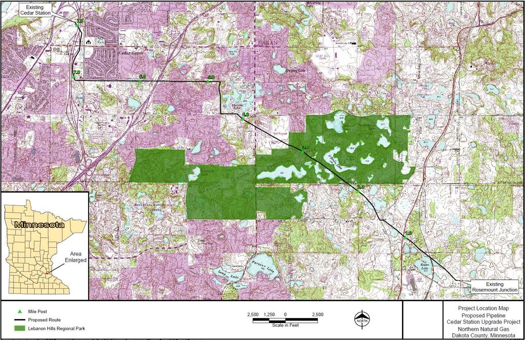
5 5


6 PHOTOGRAPHIC RECORD Company: Northern Natural Gas Company Project: Cedar Station Upgrade Project Spread/Loop/Facility: Pipeline Loop Photo No.: 1 Sta. No.: Direction: North Comments: Open area. HDD #22. ECDs were maintained. Restoration was proceeding satisfactorily. Photo No.: 2 Sta. No.: Direction: South Comments: Open area. HDD #21 exit. Northern mowed some nonnative plants that were present on the ROW. Revegetation is proceeding satisfactorily. 6

 prior to their construction. 7")
7 PHOTOGRAPHIC RECORD Company: Northern Natural Gas Company Project: Cedar Station Upgrade Project Spread/Loop/Facility: Pipeline Loop Photo No.: 3 Sta. No.: Direction: North Comments: Open area; HDD #19 entry site/hdd #20 exit site. In this staging area adjacent to the ROW, heavy rainfall overwhelmed the silt fence. Northern installed a berm to slow the water and repaired all ECDs. No concerns were noted. Photo No: 4 Sta. No.: Direction: West Comments: Maintained ROW corridor. The ROW was seeded adjacent to Sandstone Road, but topsoil was not replaced. Northern will mulch this area if cathodic protection does not begin within the next week. Revegetation along the ROW adjacent to Highline trail was proceeding satisfactorily. Northern indicated that water pooled on the trail (as seen in the photo) prior to their construction. 7


8 PHOTOGRAPHIC RECORD Company: Northern Natural Gas Company Project: Cedar Station Upgrade Project Spread/Loop/Facility: Pipeline Loop Photo No.: 5 Sta. No.: Direction: East Comments: Maintained ROW. Northern replaced Highline Trail and sidewalks in this area. The area was seeded and mulched. No concerns were noted. Vegetation adjacent to the areas that were recently disturbed was proceeding satisfactorily. Photo No.: 6 Sta. No.: Direction: West Comments: Maintained ROW. The tie-in and backfill of the pipeline in this area was completed the week prior to the inspection. The grade was being restored. No concerns were noted. 8


9 PHOTOGRAPHIC RECORD Company: Northern Natural Gas Company Project: Cedar Station Upgrade Project Spread/Loop/Facility: Pipeline Loop Photo No.: 7 Sta. No.: Direction: West Comments: Maintained ROW; Thomas Lake Road. Northern was working on restoring final grade Multiple ECDs were installed on the hillside to help manage stormwater runofff. The ECDs were functional and no problem areas were noted. Northern indicated that it was reviewing the ECDs to ensure that sediment from future storm events would be contained to the ROW. Higline Trail will be replaced in this area when construction is complete. Photo No.: 8 Sta. No.: Direction: Northeast Comments: Open area; Lebanon Hills Regional Park. The disturbed area that will be used for the pullback of HDD #8 was seeded and growth was noted. After the adjacent hillside was hydromulched, Northern installed erosion blanket to help prevent rill erosion from forming. ECDs were maintained. No concerns were noted. 9

.")
10 PHOTOGRAPHIC RECORD Company: Northern Natural Gas Company Project: Cedar Station Upgrade Project Spread/Loop/Facility: Pipeline Loop Photo No.: 9 Sta. No.: Direction: West Comments: Residential area at Interlachen Drive. The pipeline was being welded and x-rayed. ECDs and construction safety fence adjacent to the residential areas were installed and maintained, including straw bales at the entrance to the ROW off of Interlachen Road. No concerns were noted. Photo No.: 10 Sta. No.: Direction: Southeast Comments: Open area. Northern seeded and mulched the area. A small pool of water was visible on the ROW (yellow arrow). Northern is conducting research to determine if this area held water prior to construction during heavy rain events. Northern will work with the landowner to regrade the area, if necessary. 10

11 PHOTOGRAPHIC RECORD Company: Northern Natural Gas Company Project: Cedar Station Upgrade Project Spread/Loop/Facility: Pipeline Loop Photo No.: 11 Sta. No.: Direction: East southeast Comments: Wetland W-07. The area was seeded and mulched. Northern indicated that the crimping machine made some minor ruts in the area due to the saturated condition of soils. Northern has committed to repair the rutting, and mulch and reseed the area. No concerns were noted. 11
12 Document Content(s) CP Cedar Station Inspection (1).PDF
FEDERAL ENERGY REGULATORY COMMISSION FIELD INSPECTION REPORT
 FEDERAL ENERGY REGULATORY COMMISSION FIELD INSPECTION REPORT Date June 20, 2018 Project Northern Natural Gas Company Northern Lights 2017 Expansion Project Rice, Sherburne, and Isanti Counties, Minnesota
/s/ Michael T. Loeffler. Michael T. Loeffler Senior Director, Certificates and External Affairs. Attachment. September 14, 2018.
 Northern Natural Gas Company P.O. Box 3330 Omaha, NE 68103-0330 402 398-7200 September 14, 2018 Via efiling Ms. Kimberly D. Bose, Secretary Federal Energy Regulatory Commission 888 First Street, N.E. Washington,
Information for File # JTF
 Information for File # 2013-04665-JTF Applicant Corps Contact Enbridge Energy, Limited Partnership Josh Fitzpatrick Address 1554 Highway 2, Suite 2, Two Harbors, MN 55616 E-Mail joshua.t.fitzpatrick@usace.army.mil
EROSION & SEDIMENT CONTROL
 EROSION & SEDIMENT CONTROL Surface Water Protection During Well Site Construction Kelly Kees, PE WVDEP, Office of Oil and Gas SEDIMENT & EROSION CONTROL PLANS Per West Virginia State Code 22-6-6(d) 22-6A-7(c),
FEDERAL ENERGY REGULATORY COMMISSION WASHINGTON, D.C
 FEDERAL ENERGY REGULATORY COMMISSION WASHINGTON, D.C. 20426 OFFICE OF ENERGY PROJECTS August 10, 2018 In Reply Refer To: OEP/DG2E/Gas Branch 3 Mountain Valley Pipeline LLC CP16-10-000 Matthew Eggerding,
Piles, Trenching, Inverters, Cables, Material Deliveries
 Agricultural Inspection Report General Information Project Name Albany Date of Inspection 20161012 Start/End Time 7:50 am Inspector s Name(s) Inspector s Title(s) Describe present phase of construction
Methods, approaches, and procedures to minimize active agricultural land impacts during pipeline construction, surface restoration, and pipeline
 Agricultural Impact Minimization Plan Methods, approaches, and procedures to minimize active agricultural land impacts during pipeline construction, surface restoration, and pipeline operation. PennEast
Piles, inverters, trenching, cabling, assembly.
 Agricultural Inspection Report General Information Project Name Montrose Date of Inspection 11/9/2016 Start/End Time 7:00 am Inspector s Name(s) Inspector s Title(s) Describe present phase of construction
Plan of Development Mountain Valley Pipeline Project. APPENDIX M Winter Construction Plan
 APPENDIX M October 20, 2017 Appendix M Prepared by: October 20, 2017 TABLE OF CONTENTS 1.0 INTRODUCTION... M-1 2.0 STABILIZATION/WINTERIZATION... M-2 3.0 EROSION AND SEDIMENT CONTROL MEASURES... M-3 4.0
UPLAND EROSION CONTROL, REVEGETATION, AND MAINTENANCE PLAN
 UPLAND EROSION CONTROL, REVEGETATION, AND MAINTENANCE PLAN 01/17/2003 VERSION UPLAND EROSION CONTROL, REVEGETATION, AND MAINTENANCE PLAN TABLE OF CONTENTS I. APPLICABILITY... 1 II. SUPERVISION AND INSPECTION...
SUPPORTING DOCUMENT STORMWATER POLLUTION PREVENTION PLAN (SWPPP) NARRATIVE
 NARRATIVE") SUPPORTING DOCUMENT STORMWATER POLLUTION PREVENTION PLAN (SWPPP) NARRATIVE Please complete this narrative form and submit with your SWPPP drawings. Refer to Kitsap County Stormwater Design Manual Vol.
SUPPORTING DOCUMENT STORMWATER POLLUTION PREVENTION PLAN (SWPPP) NARRATIVE Please complete this narrative form and submit with your SWPPP drawings. Refer to Kitsap County Stormwater Design Manual Vol.
Methods, approaches, and procedures to minimize active agricultural land impacts during pipeline construction, surface restoration, and pipeline
 Agricultural Impact Minimization Plan Methods, approaches, and procedures to minimize active agricultural land impacts during pipeline construction, surface restoration, and pipeline operation. PennEast
Information for File # ARC
 Information for File # 2015-02781-ARC Applicant Corps Contact Enbridge Energy, Limited Partnership Andrew R Chambers Address 600 South Lake Avenue, Suite 211, Duluth, MN 55802 E-Mail Andrew.R.Chambers@usace.army.mil
Tour of Nonpoint Source Pollution Reduction Projects in the Western Lake Superior Watershed
 Tour of Nonpoint Source Pollution Reduction Projects in the Western Lake Superior Watershed On September 8 th, 2006 Minnesota's Lake Superior Coastal Program and the South St Louis Soil and Water Conservation
City of Stoughton Erosion Control Permit Application (effective 2/6/2018)
") City of Stoughton Erosion Control Permit Application (effective 2/6/2018) Incomplete applications will not be accepted Project Name: Address of subject property: Landowner Name(s): Applicant Name: Landowner
City of Stoughton Erosion Control Permit Application (effective 2/6/2018) Incomplete applications will not be accepted Project Name: Address of subject property: Landowner Name(s): Applicant Name: Landowner
Adaptive Management of Erosion and Sediment Control Best Management Practices (BMPs) Presenter: Denis Rushton, P. Eng. Date: May 18, 2016
 Presenter: Denis Rushton, P. Eng. Date: May 18, 2016") Adaptive Management of Erosion and Sediment Control Best Management Practices (BMPs) Presenter: Denis Rushton, P. Eng. Date: May 18, 2016 Adaptive Management (AM) The definition of AM for the purpose of
Adaptive Management of Erosion and Sediment Control Best Management Practices (BMPs) Presenter: Denis Rushton, P. Eng. Date: May 18, 2016 Adaptive Management (AM) The definition of AM for the purpose of
Preventing Storm Water Pollution: What We Can Do
 Preventing Storm Water Pollution: What We Can Do ~Employee Training Series~ Land Disturbances PREPARED IN COOPERATION WITH THE Texas Commission on Environmental Quality AND U.S. ENVIRONMENTAL PROTECTION
Storm Water Basics for Construction Sites Presented by Representatives from the City of Grass Valley and Nevada County
 September 22nd, 2015 3:30PM Sign up at: www.stormwaterawareness.org Workshop is free! Nevada County Contractor s Association 149 Crown Point Ct. Grass Valley, CA 95945 Storm Water Basics for Construction
Decision Notice. Proposed Action
 Decision Notice Paving Weld County Road 105 USDA Forest Service Arapaho and Roosevelt National Forest and Pawnee National Grassland Pawnee National Grassland Ranger District Weld County, Colorado November
CITY OF TUMWATER 555 ISRAEL RD. SW, TUMWATER, WA (360) (360) (FAX)
 (360) (FAX)") CITY OF TUMWATER 555 ISRAEL RD. SW, TUMWATER, WA 98501 (360) 754-4180 (360) 754-4126 (FAX) Email: cdd@ci.tumwater.wa.us APPENDIX II-C SHORT FORM CONSTRUCTION STORMWATER POLLUTION PREVENTION PLAN (SWPPP)
CITY OF TUMWATER 555 ISRAEL RD. SW, TUMWATER, WA 98501 (360) 754-4180 (360) 754-4126 (FAX) Email: cdd@ci.tumwater.wa.us APPENDIX II-C SHORT FORM CONSTRUCTION STORMWATER POLLUTION PREVENTION PLAN (SWPPP)
Urban Conservation Practice Physical Effects ESTABLISHMENT, GROWTH, AND HARVEST NUTRIENT MANAGEMENT
 NOT WELL 800 - Urban Stormwater Wetlands A constructed system of shallow pools that create growing conditions for wetland plants to lessen the impacts of stormwater quality and quantity in urban areas.
ENBRIDGE GAS DISTRIBUTION INC. Proposed Relocation for Ninth Line, Markham and Whitchurch-Stouffville. Environmental Screening Report
 Page 1 of 18 ENBRIDGE GAS DISTRIBUTION INC. Proposed Relocation for Ninth Line, Markham and Whitchurch-Stouffville Environmental Screening Report July 2011 Page 2 of 18 Table of Contents 1.0 INTRODUCTION
Shelbyville, KY Stormwater Best Management Practices. Section 2 EROSION PREVENTION AND SEDIMENT CONTROL PLAN
 Section 2 EROSION PREVENTION AND SEDIMENT CONTROL PLAN 2.1 Requirements The City of Shelbyville, KY will require an Erosion Prevention and Sediment Control (EPSC) Plan for most types of development construction.
Drainage Analysis-Newgate/Phelps & Hatchett Hill Road Areas Rev. 0 Erosion & Sediment Control Measures
 Drainage Analysis-Newgate/Phelps & Hatchett Hill Road Areas Rev. 0 Erosion & Sediment Control Measures 4.0 EROSION & SEDIMENT CONTROL MEASURES After performing the analysis summarized above, Burns & McDonnell
ITEM 164 SEEDING AND EROSION CONTROL BLANKET
 AFTER NOVEMBER 1, 2008 ITEM 164 SEEDING AND EROSION CONTROL BLANKET 164.1 Description. This Item shall govern for preparing the ground, sowing of seeds, application of a fertilizer, and stabilization with
Kittson Parkway / Watershed Park Parking Lot
 Kittson Parkway / Watershed Park Parking Lot Date Constructed: Summer 2005 Site Location / Description: Kittson Parkway, North Delta, British Columbia. Permeable parking lot adjacent to Watershed Park;
The Low Risk Site Handbook
 The Low Risk Site Handbook for Erosion Prevention and Sediment Control The content of this Handbook is adapted from the New York State Standards and Specifications for Erosion and Sediment Control-August
December 13, 2005 Meeting Status of NPDES Post Fire BMPs
 December 13, 2005 Meeting Status of NPDES Post Fire BMPs Agenda Overview of Current Operations At SSFL Impacts of Fire At SSFL Rebuilding & Improvement of BMPs Future Activities Site Tour Close-out 1 Santa
City of Sun Prairie Wetland Buffer Reduction Request
 City of Sun Prairie Wetland Buffer Reduction Request Westside Development Area January 9, 2017 Prepared by: City of Sun Prairie 300 E. Main Street Sun Prairie, WI 53590 BACKGROUND The City of Sun Prairie
Executive Committee Meeting Addendum. #7/15 July 3, :30 A.M. HEAD OFFICE, 101 EXCHANGE AVENUE, VAUGHAN Members:
 Executive Committee Meeting Addendum #7/15 July 3, 2015 9:30 A.M. HEAD OFFICE, 101 EXCHANGE AVENUE, VAUGHAN Members: Maria Augimeri Michael Di Biase David Barrow Ronald Chopowick Vincent Crisanti Glenn
General Information. Site Conditions. 9b 9b. 9a 1b. Best Management Practices Illustration
 Model Construction SWPPP Planning & Development Services 1800 Continental Place Mount Vernon WA 98273 voice 360-416-1320 inspections 360-416-1330 www.skagitcounty.net/stormwaterpermitting Permit #: General
2018 Annual Landfill Inspection Report
 2018 Annual Landfill Inspection Report Landfill H.W. Pirkey Plant Southwestern Electric Power Company Hallsville, Texas December 17, 2018 Prepared for: Southwestern Electric Power Company H.W. Pirkey Plant
MARBLE RIVER WIND POWER PROJECT Agricultural Protection Measures
 MARBLE RIVER WIND POWER PROJECT Siting Considerations 1. Locate access roads and, to the extent allowed by local laws, wetlands and topography, individual wind turbines and other structures along field
Using the Updated RI Soil Erosion and Sediment Control Handbook. The Introductory Workshop for RIDEM/CRMC Staff January 23, 2015
 Using the Updated RI Soil Erosion and Sediment Control Handbook The Introductory Workshop for RIDEM/CRMC Staff January 23, 2015 URI Cooperative Extension NEMO URI Cooperative Extension NEMO White Oak,
ATTACHMENT 1 WILSON MINE LECROY AREA SEMIPERMANENT DEWATERING SYSTEM
 ATTACHMENT 1 WILSON MINE LECROY AREA SEMIPERMANENT DEWATERING SYSTEM Reclamation plans for the Wilson Mine Lecroy area were approved by the Arkansas Department of Environmental Quality with a passive barrier
Soil Reclamation and Site Reinstatement
 APPENDIX 6 Soil Reclamation and Site Reinstatement Purpose To undertake soil reclamation, erosion protection, Site restoration and reinstatement, taking into account natural processes, operational requirements
SOP 6: Erosion and Sedimentation Control SOP 6: EROSION AND SEDIMENTATION CONTROL
 Standard Operating Procedures Central Massachusetts Regional Stormwater Coalition SOP 6: Erosion and Sedimentation Control SOP 6: EROSION AND SEDIMENTATION CONTROL Erosion and sedimentation from land-disturbing
Wisconsin Contractors Institute Continuing Education
 Wisconsin Contractors Institute Continuing Education Erosion & Sediment Control Course # 12775 2 hours Wisconsin Contractors Institute N27 W23953 Paul Road, Suite 203 Pewaukee, WI 53072 Website: www.wicontractorsinstitute.com
Erosion Control for Home Builders in the. City of Jacksonville
 Erosion Control for Home Builders in the City of Jacksonville Eroding construction sites are a leading cause of water quality problems in Jacksonville. For every acre under construction, about a dump truck
Alternative Names: Erosion Control Matting, Erosion Control Netting, Rolled Erosion Control Products (RECP)
") 4.5-s EROSION CONTROL BLANKET SYSTEM Alternative Names: Erosion Control Matting, Erosion Control Netting, Rolled Erosion Control Products (RECP) DESCRIPTION Erosion control blanket systems are woven or
4.5-s EROSION CONTROL BLANKET SYSTEM Alternative Names: Erosion Control Matting, Erosion Control Netting, Rolled Erosion Control Products (RECP) DESCRIPTION Erosion control blanket systems are woven or
Stormwater Standards. Clackamas County Service District No. 1. Planting Guide for Buffers
 Stormwater Standards Clackamas County Service District No. 1 APPENDIX B Planting Guide for Buffers Table of Contents Appendix B - Planting Guide for Buffers... Page B.1 General... 1 B.1.1 Introduction...
WQ-23 MOUNTAINOUS AND STEEP SLOPE SITES
 Greenville County Technical Specification for: WQ-23 MOUNTAINOUS AND STEEP SLOPE SITES 1.0 Mountainous and Steep Slope Sites 1.1 Description The geographic locations of portions of Greenville County are
A. Install all temporary erosion control measures (in accordance with MNDOT General Conditions 2573) prior to site disturbance.
 prior to site disturbance.") The language provided in these specifications is meant to serve as a reminder and provide a generic example of the type of language that should be provided in final construction documents. This language
The language provided in these specifications is meant to serve as a reminder and provide a generic example of the type of language that should be provided in final construction documents. This language
BIORETENTION CELLS. Green Infrastructure For Stormwater Management WHAT ARE BIORETENTION CELLS? WHERE ARE BIOCELLS INSTALLED?
 BIORETENTION CELLS Green Infrastructure For Stormwater Management WHAT ARE BIORETENTION CELLS? Bioretention cells (or biocells) are one of the most widely used green infrastructure practices for managing
Soil Erosion and Sediment Control
 PDHonline Course C188 (3 PDH) Soil Erosion and Sediment Control Instructor: John Poullain, PE 2012 PDH Online PDH Center 5272 Meadow Estates Drive Fairfax, VA 22030-6658 Phone & Fax: 703-988-0088 www.pdhonline.org
5/15/2013. Basin Area. Vegetation. Rainfall & Runoff. Soil Type. Topics. Factors Influencing Erosion. Factors Influencing Erosion
 Topics Erosion, TESC and Construction sequencing Procedures and timing Remedies for failing sites Curtis Hinman WSU Extension and Bio Systems Eng. Faculty Low Impact Development Specialist chinman@wsu.edu
Illinois Urban Manual
 Illinois Urban Manual Jim Nelson: Association of Illinois Soil and Water Conservation Districts (AISWCD) Funding for this project provided, in part, by the Grand Victoria Foundation of Elgin IL, the Governor
King and Queen County Department of Building & Zoning P.O. Box 177, King and Queen Courthouse, VA Phone: Fax:
 King and Queen County Department of Building & Zoning P.O. Box 177, King and Queen Courthouse, VA 23085 Phone: 804-785-5975 Fax: 804-769-5000 Water Quality Impact Assessment (WQIA) Application Note: Encroachment
SECTION 900 TURF ESTABLISHMENT
 SECTION 900 901.0 DESCRIPTION This section covers the furnishing of all labor, materials, tools, equipment and performances of all work and services necessary or incidental to turf restoration as indicated
TOWN OF BURLINGTON Conservation Commission
 TOWN OF BURLINGTON Conservation Commission MINUTES OF Approved May 26, 2016 Members Present: Members Absent: Also Present: Chair L. Cohen, K. Melanson, I. Deb, A. McNamara Vice-Chair W. Boivin, J. Lynch,
PLANNED UNIT DEVELOPMENT STAFF REPORT Date: June 2, 2016
 # 9 ZON2016-01032 PLANNED UNIT DEVELOPMENT STAFF REPORT Date: June 2, 2016 DEVELOPMENT NAME JJT Properties LLC LOCATION 1147 & 1151 East I-65 Service Road South and 1180 Sledge Drive (Southeast corner
Town of Essex Small Site Erosion Control Guide
 Town of Essex Small Site Erosion Control Guide Why do we need to protect against erosion? Water Quality: Erosion and the transport of sediment and pollutants impacts the water quality of nearby streams
A. INTRODUCTION AND SUMMARY OF FINDINGS B. EXISTING CONDITIONS. Table 10-1 Adjacent Storm Drains
 Chapter 10: Stormwater Management A. INTRODUCTION AND SUMMARY OF FINDINGS This chapter describes existing and proposed stormwater management on the Site. Potential impacts to stormwater infrastructure
PLANNING APPROVAL & PLANNED UNIT DEVELOPMENT Date: November 2, 2017
 PLANNING APPROVAL & PLANNED UNIT DEVELOPMENT Date: November 2, 2017 DEVELOPMENT NAME LOCATION Mobile Christian School 5900 Cottage Hill Road (North side of Cottage Hill Road, 230 ± West of Freemont Drive
12/7/2007. Christopher B. Burke Engineering West, Ltd Aux Sable Creek Watershed Plan Update 1
 The ABC s of BMP s Aux Sable Watershed Plan St. Charles, IL Why are BMP s Important Best Management Practices (BMPs) developed as a set of practices which help to achieve goals of the Clean Water Act and
Breakthrough Innovations
 Breakthrough Innovations Project Title: Bioengineering for Stabilization of Critical Slopes Project Team: Lori Belz Principle Investigator John Benson Steve Kortuem Leo Holm Introduction: One of the problems
WELCOME! 8 8:30 6: TH STREET IMPROVEMENTS. Open House. Presentation & Q&A
 WELCOME! 168 TH STREET IMPROVEMENTS 6:30 Open House 7 8 Presentation & Q&A 8 8:30 Open House WELCOME Todd Pfitzer City of Omaha Engineer Bob Stubbe City of Omaha Public Works Director Jon Meyer Project
Vegetated Filter Strips and Buffers
 3.15 Sediment Control Description: Buffer strips (existing vegetation) and filter strips (planted vegetation) are sections of vegetated land adjacent to disturbed areas. They are designed with low slopes
startup. Construction of contractor entrance off University City Blvd connecting to Lot 8 has started.
 Campus Construction Situation Report #6 March 15, 2012 Hechenbleikner Lake Dam No change from previous notice Dewatering maintenance continues. Major construction activity will begin mid April and with
REFERENCE DRAWINGS FOR 332 W. MAIN STREET ROCK HILL, SOUTH CAROLINA
 REFERENCE DRAWINGS FOR REET ROCK HILL, SOUTH CAROLINA COVER SHEET 1 OF 6 GENERAL NOTES 2 OF 6 REMOVE WIRE AND NYLON TWINE FROM BALL AND CANOPY. SOAK ROOT BALL AND PLANT PIT IMMEDIATELY AFTER INSTALLATION.
Project: Mooney Lake Preserve Received: Location: 300 Sixth Ave. N., Orono Complete: Noticed:
 Permit Application No.: 15-445 Rules: Erosion Control, Wetland Protection, & Stormwater Management Applicant: BPS Properties, LLC Project: Mooney Lake Preserve Received: 8-24-15 Location: 300 Sixth Ave.
Triangle Land Conservancy Conservation Area Monitoring Report Carolina North
 Triangle Land Conservancy Conservation Area Monitoring Report Carolina North Property Name: Bolin Creek West Conservation Area Date of visit: April 11, 2018 County: Orange Property Type: Restrictive Covenants
Chapter Six: Tree Removal and Erosion Control
 Chapter Six: Tree Removal and Erosion Control Through the combination of canopy and roots, trees help protect and stabilize the land. Their removal requires proper planning and adherence to land-based
SECTION TURF AND GRASSES
 SECTION 32 92 00 TURF AND GRASSES PART 1: GENERAL 1.01 DESCRIPTION Restore all disturbed grass and landscaped areas to conditions equal to or better than before the work began and to the satisfaction of
Stormwater Drainage Assessment For Single Family Residence
 Stormwater Drainage Assessment For Single Family Residence Project Name: SEADER SFD Project Address: 2301 NE Perkins Way, Lake Forest Park, King County WA. Parcel Number(s): Tax Parcel No. 86659-00181
Osceola County Board of County Commissioners 1 Courthouse Square, Suite 1100 Kissimmee, FL
 1/10/11 Item Number DRI08-0006 Osceola County Board of County Commissioners 1 Courthouse Square, Suite 1100 Kissimmee, FL 34741 407-742-0200 Applicant & Owner Center Lake Properties, LLLP and Formally
LOUISIANA STATE UNIVERSITY COMPREHENSIVE & STRATEGIC CAMPUS MASTER PLAN. APPENDIX G - Stormwater Study Findings & Stormwater Solutions
 LOUISIANA STATE UNIVERSITY COMPREHENSIVE & STRATEGIC CAMPUS MASTER PLAN APPENDIX G - Stormwater Study Findings & Stormwater Solutions LSU: MP Narrative July 2017 3.5 Open Space Existing Conditions The
STORWATER AWARNESS TRAINING
 STORWATER AWARNESS TRAINING INTRODUCTION What is stormwater? It is rainfall and snowmelt that did not soak into the ground. It forms run-off which flows into storm drains and ends up in rivers, lakes,
RAIN GARDEN ILLINOIS URBAN MANUAL PRACTICE STANDARD. (feet) CODE 897 DEFINITION
 CODE 897 DEFINITION") ILLINOIS URBAN MANUAL PRACTICE STANDARD RAIN GARDEN (feet) CODE 897 Source: Kendall County Soil and Water Conservation District DEFINITION Rain gardens are small, shallow, flat bottomed depressions constructed
ILLINOIS URBAN MANUAL PRACTICE STANDARD RAIN GARDEN (feet) CODE 897 Source: Kendall County Soil and Water Conservation District DEFINITION Rain gardens are small, shallow, flat bottomed depressions constructed
All materials in this presentation are taken from materials produced by:
 1 PART I 2 All materials in this presentation are taken from materials produced by: Georgia Soil and Water Conservation Commission 4310 Lexington Road P.O. Box 8024 Athens, GA 30603 706-542-3065 Fax 706-542-4242
Vegetated Filter Strips and Buffers
 3.15 Sediment Control Description: Buffer strips (existing vegetation) and filter strips (planted vegetation) are sections of vegetated land adjacent to disturbed areas. They are designed with low slopes
EnkaTech Note. Installation Guide for Enkamat Slopes and Channels. Site Preparation. Anchor Trench. Enkamat Installation
 EnkaTech Note Installation Guide for Enkamat Slopes and Channels Site Preparation For both slope and channel applications, the site must be shaped to the design specifications (grade, geometry, soil compaction,
Weston s Wetlands, Stormwater, & Open Space
 Weston s Wetlands, Stormwater, & Open Space Weston s Wetlands, Stormwater, & Open Space Conservation Commission Role and Responsibilities Laws that protect wetlands What residents can do to protect wetlands
PLANNING APPROVAL & PLANNED UNIT DEVELOPMENT Date: April 6, 2017
 PLANNING APPROVAL & PLANNED UNIT DEVELOPMENT Date: April 6, 2017 DEVELOPMENT NAME LOCATION Mobile Christian School 5900 Cottage Hill Road (North side of Cottage Hill Road, 230 ± West of Freemont Drive
Stormwater Pollution Prevention Plan Oneonta Heights Oneonta, NY TABLE OF CONTENTS PAGE
 Oneonta Heights Oneonta, NY TABLE OF CONTENTS PAGE I. INTRODUCTION... 2 II. EXISTING CONDITIONS... 3 A. Topography/ Drainage... 3 B. Soils... 3 C. Wetlands... 3 D. Floodplain... 3 E. NYSDEC Environmental
Department of Agriculture. Conservation Service. United States. Natural Resources REVISED 8/26/16
 GENERAL NOTES: SYMBOL LEGEND 1. All work shall comply with the constriction specifications, drawings, project-specific quality assurance plan and other contract requirements. 2. All notes on the drawings
Buffer Zone (BZ) Stream Protection. The width and plant composition of a buffer zone will determine its effectiveness.
 Stream Protection. The width and plant composition of a buffer zone will determine its effectiveness.") Buffer Zone (BZ) Figure BZ-1 Buffer Zone in Agricultural Area Practice Description A buffer zone is a strip of plants adjacent to land-disturbing sites or bordering streams, lakes, and wetlands that provides
Buffer Zone (BZ) Figure BZ-1 Buffer Zone in Agricultural Area Practice Description A buffer zone is a strip of plants adjacent to land-disturbing sites or bordering streams, lakes, and wetlands that provides
10.14 ERRATA UPDATE SHEET 3
 Executive Committee Meeting Addendum #13/15 January 15, 2016 9:30 A.M. HEAD OFFICE, 101 EXCHANGE AVENUE, VAUGHAN Members: Maria Augimeri Michael Di Biase David Barrow Vincent Crisanti Glenn De Baeremaeker
Rolled Erosion Control Products (RECPs) General Usage and Installation Guidelines for Slope
 General Usage and Installation Guidelines for Slope") March 2014 Version 1.0 Rolled Erosion Control Products (RECPs) General Usage and Installation Guidelines for Slope Erosion Control Technology Council IMPORTANT NOTICE on Safety Procedures: Manufacturer
March 2014 Version 1.0 Rolled Erosion Control Products (RECPs) General Usage and Installation Guidelines for Slope Erosion Control Technology Council IMPORTANT NOTICE on Safety Procedures: Manufacturer
Vegetation Management
 Vegetation Management GENERAL CONSTRUCTION PRACTICE Best practice vegetation management involves giving appropriate consideration to the following issues. Not all the issues will be relevant on every site.
Project Applicant Checklist for NPDES Permit Requirements SAN MATEO COUNTYWIDE STORMWATER POLLUTION PREVENTION PROGRAM
 Project Applicant Checklist for NPDES Permit Requirements SAN MATEO COUNTYWIDE STORMWATER POLLUTION PREVENTION PROGRAM I. PROJECT DATA Project Name Bay Meadows Development Phase II Project Address 2600
Feet. Overland. Drainage Area Boundary. To Swale. Swale. To Catch Basin. Culvert Pipe. To Drain Outfall. NRCS Soil Area Boundary
 0 25 50 00 Feet Parcel Boundary, Approximate 202 LIDAR 2 FT CONTOURS, VCGI BING AERIAL NRCS SOIL MAPPING MMI FIELD DATA Culvert Pipe Swale 0 Scale: "=40' SOURCE(S): NRCS Soil Area Boundary Overland st
Protect Stormwater Quality Project and Site Management Training for General Contractors. Presenter Becky Pearson Professional Civil Engineer
 Protect Stormwater Quality Project and Site Management Training for General Contractors Presenter Becky Pearson Professional Civil Engineer Part II Best Management Practices (BMPs) What is a Best Management
Information for File # ARC
 Information for File # 2017-03115-ARC Applicant Consultant Corps Contact Bob Manzoline St. Louis and Lake Counties Regional Rail Authority Natalie White Short Elliot Hendrickson (SEH) Inc. Andrew R Chambers
CITY PLANNING COMMISSION AGENDA ITEM NO: 8 STAFF: ANDREW FIRESTINE FILE NO: CPC PUD QUASI-JUDICIAL
 Page 97 CITY PLANNING COMMISSION AGENDA ITEM NO: 8 STAFF: ANDREW FIRESTINE FILE NO: CPC PUD 05-00232 QUASI-JUDICIAL PROJECT: APPLICANT: OWNER: CORNERSTONE BAPTIST CHURCH BILL BROWN AIA P.C. CORNERSTONE
Part IV(a): BMPs for Erosion, Sediment, Velocity Control
: BMPs for Erosion, Sediment, Velocity Control") Part IV(a): BMPs for Erosion, Sediment, Velocity Control Find Design Standards and Specifications for Iowa Erosion and Sediment Control Practices at: www.iowasudas.org Erosion Control Keeping the soil
Part IV(a): BMPs for Erosion, Sediment, Velocity Control Find Design Standards and Specifications for Iowa Erosion and Sediment Control Practices at: www.iowasudas.org Erosion Control Keeping the soil
Iowa 100 Extension Project Visualizations for Design and Public Involvement ASCE Transportation Conference November 6, 2013 Ames, Iowa
 Iowa 100 Extension Project Visualizations for Design and Public Involvement 2013 ASCE Transportation Conference November 6, 2013 Ames, Iowa Agenda Project Corridor Constraints Key Features Project History
Request for an Exception to the Napa County Road and Street Standards
 F Request for an Exception to the Napa County Road and Street Standards Shed Creek Winery Use Permit P16-327 and Use Permit Exception to the Conservation Regulations P17-178 Planning Commission Hearing
PLANNED UNIT DEVELOPMENT & SUBDIVISION STAFF REPORT Date: May 18, 2017
 & PUD-0000102-2017 PLANNED UNIT DEVELOPMENT & SUBDIVISION STAFF REPORT Date: May 18, 2017 NAME SUBDIVISION NAME Dauphin Creek Estates Subdivision Dauphin Creek Estates Subdivision LOCATION CITY COUNCIL
East Coast Erosion Blankets
 Protect Your Landscapes with East Coast Erosion Blankets Soil erosion can be a serious problem, resulting in catastrophic damage to water sources, landscaping, and wildlife. Repairing damage caused by
HEALTH SCIENCES BUILDING REDEVELOPMENT PROJECT
 INTRODUCTION In recent years, the University of Cincinnati (University) has demonstrated a commitment to identifying and implementing sustainable goals and objectives throughout University s Uptown Campuses.
POST-FIRE RESTORATION Dos and Don ts
 POST-FIRE RESTORATION Dos and Don ts USDA Natural Resources Conservation Service The NRCS/RCD office is located at: 744 LA GUARDIA ST BLDG A SALINAS, CA 93905-3354 (831) 424-1036 (NRCS) (831) 424-1036
A comparison of Traditional and Prefabricated Encapsulated Soil Lifts
 A comparison of Traditional and Prefabricated Encapsulated Soil Lifts Jane Herbert, Senior Extension Educator 2014 Wisconsin Lakes Convention Background on shoreline erosion control in MI KBS Shoreline
2016 Annual Inspection Report
 2016 Annual Inspection Report for Compliance with the Coal Combustion Residuals Rule (40 CFR Part 257) Hayden Station 13125 U.S. Highway 40 Hayden, Colorado 81638 January 18, 2017 Table of Contents Certification...
This material is protected by copyright and is the exclusive property of Enbridge Pipelines Inc Water Crossings. 4.
 The Environmental Report for the GTA Project contains the following references to the Environmental Guidelines for Construction, June 2012. The referenced sections of the Environmental Guidelines for Construction
Caribbean Area PO Box San Juan, PR Page Topics
 Caribbean Area PO Box 364868 San Juan, PR 00936-4868 IBM Plaza 654 Muñoz Rivera Ave. Suite 604 Hato Rey, PR 00918-4123 Page Topics Guide to Erosion and Sediment Control in Urban Areas Erosion and Sedimentation
Glencoe Elementary School Parking Lot Retrofit 825 SE 51 st Street
 Glencoe Elementary School Parking Lot Retrofit 825 SE 51 st Street Project Summary Project Type: Technologies: Institutional parking lot retrofit demonstration project Vegetated infiltration swale with
Additional personnel accompanying me on the site inspection today included Paula Fitzgerald (Biosar) and Ryan Molsee (Enel).
 and Ryan Molsee (Enel).") Dodge Center Date of Inspection 20161114 Start/End Time 12:00 pm Assembly complete, CCTV cabling and trenching, Decompaction equipment testing Partly cloudy, temperature in the low to mid-40 s Additional
Dodge Center Date of Inspection 20161114 Start/End Time 12:00 pm Assembly complete, CCTV cabling and trenching, Decompaction equipment testing Partly cloudy, temperature in the low to mid-40 s Additional
VEGETATED SLOPE STABILIZATION DESCRIPTION APPLICABILITY. Advantages
 4.2-d VEGETATED SLOPE STABILIZATION Alternative Names: Willow Wattles, Live Bundles, Fascines, Live Staking, Joint Planting, Branch Packing, Brush Layering, and Brush Matting DESCRIPTION Vegetated slope
Single most pervasive problem: Polluted runoff from watershed development
 What are Some Potential Threats to Maine s Lakes Acid rain Mercury contamination Aquatic Invaders: The Milfoil threat Loss of critical habitat Global climate change Single most pervasive problem: Polluted