Planning & Zoning Commission Staff Report
|
|
|
- Elfreda McCarthy
- 5 years ago
- Views:
Transcription
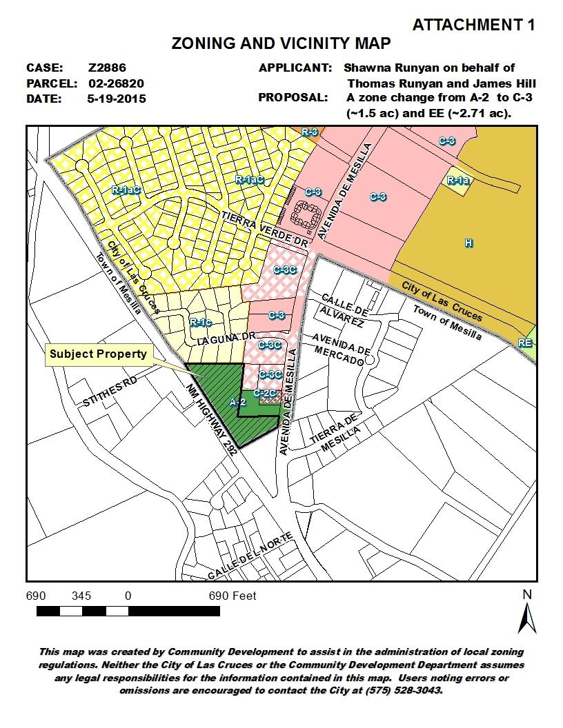
 Avenida de Mesilla Zone Change Thomas Runyan and James Hill LOCATION: 1900 Avenida de Mesilla, Parcel 02-26820 COUNCIL DISTRICT: 4 (Nathan Small) SIZE: 4.")
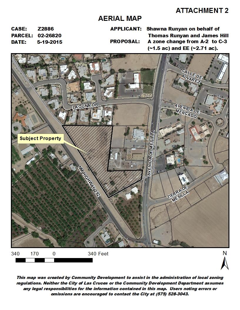
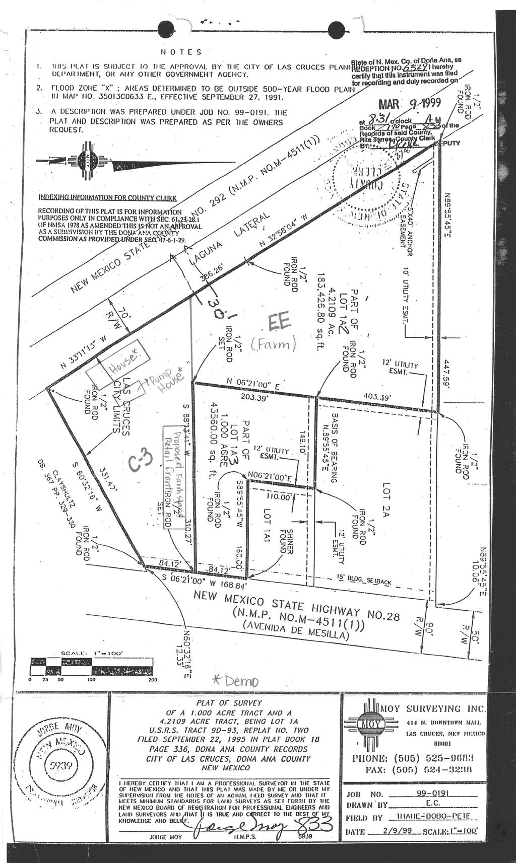
1 Planning & Zoning Commission Staff Report Meeting Date: May 26, 2015 Drafted by: Katherine Harrison-Rogers CASE # Z2886 PROJECT NAME: APPLICANT/ REPRESENTATIVE: Shawna Runyan PROPERTY OWNER: 1840 (previously 1900) Avenida de Mesilla Zone Change Thomas Runyan and James Hill LOCATION: 1900 Avenida de Mesilla, Parcel COUNCIL DISTRICT: 4 (Nathan Small) SIZE: 4.21 ac EXISTING ZONING/ OVERLAY: REQUEST/ APPLICATION TYPE: Avenida de Mesilla Gateway Overlay District A zone change from A-2 (Rural Agriculture) to EE (Equestrian Estates) for the northern 2.71± acres and to C-3 (Commercial High Intensity) for the southern 1.5± acres. EXISTING USE(S): PROPOSED USE(S): STAFF RECOMMENDATION: Vacant: single-family home recently demolished Northern property for agriculture and the southern portion for commercial and retail purposes Yes based on findings TABLE 1: CASE CHRONOLOGY Date Action April 6, 2015 Application submitted to Development Services April 6, 2015 Case sent out for review to all reviewing departments April 14, 2015 Staff reviews and recommends approval of the zone change April 21, 2015 All comments returned by all reviewing departments May 8, 2015 Sign posted on property May 10, 2015 Newspaper advertisement May 11, 2015 Public notice letter mailed to neighboring property owners May 26, 2015 Planning and Zoning Commission public hearing P.O. BOX LAS CRUCES. NEW MEXICO I AN EQUAL OPPORTUNITY EMPLOYER
2 SECTION 1: SYNOPSIS OF PROPOSAL The applicant, Shawna Runyan on behalf of Thomas Runyan and James Hill, property owners, is requesting to rezone a property from A-2 (Rural Agriculture) to EE (Equestrian Estates) for the northern 2.71± acres and C-3 (Commercial High Intensity) for the southern 1.5± acres. The A-2 zone no longer exists and the applicant desires to utilize the northern property for agriculture and the southern portion for commercial and retail purposes. The parcel is located at 1840 Avenida de Mesilla approximately 536± feet north of the intersection of Avenida de Mesilla and HWY 292. TABLE 2: DEVELOPMENT STANDARDS & SITE CHARACTERISTICS Standard A-2 EE C-3 Max # of DU/parcel 1 N/A N/A Max Density N/A (DU/ac.) Lot Area 10 ac 1 AC 21,780 sq. feet Lot Width 120 feet 100 feet 60 feet Lot Depth 200 feet 100 feet 70 feet Structure Height 35 feet 35 feet *60 feet (*Ave de Mesilla overlay limits to 40 feet) Setbacks Front 50 feet 25 feet 15 feet Side 20 feet 15 feet 15 or 0 feet Rear 50 feet 15 feet 5 or 0 feet Landscaping % of total (less building pad & screened storage) Buffering Bufferyard Screen Type 15% per the Avenida de Mesilla Gateway Overlay 10 feet between parking lot and lot line per the Avenida de Mesilla Gateway Overlay landscaped berm per the Avenida de Mesilla Gateway Overlay TABLE 3: SPECIAL CHARACTERISTICS 15% 15% N/A Characteristic Applies to Project? Explanation *15 feet (*additional Avenida de Mesilla Gateway Overlay provisions apply) N/A Semi-opaque Opaque *10 feet (*additional Avenida de Mesilla Gateway Overlay provisions apply) EBID facilities No Laguna Lateral adjacent to property Medians/ parkways landscaping No Avenida de Mesilla is NM State Highway 28: no City Jurisdiction Other No N/A Page 2 of 7 Planning Commission Staff Report
3 TABLE 4: ADJACENT ZONING AND LAND USE INFORMATION Location Existing Use Overlay District Zoning Designation Subject Property Vacant Avenida de Mesilla A-2 (Rural Agricultural) Gateway Overlay Zone North Single-family Residential and Commercial Retail Avenida de Mesilla Gateway Overlay Zone R-1c (Single-family low density) & A-2 (Rural South East West Agricultural and Singlefamily residential Commercial: Hotel/Restaurant Agricultural and Singlefamily residential N/A Town of Mesilla & Avenida de Mesilla Gateway Overlay Zone N/A Agricultural) Town of Mesilla Town of Mesilla & C-3c (High Intensity Commercial, conditional) Town of Mesilla TABLE 5: PARCEL LAND USE HISTORY Number Permit Ordinance Resolution Status N/A N/A N/A SECTION 2: REVIEWING DEPARTMENT/AGENCY RECOMMENDATIONS Department Name Approval Conditions (Yes/No) (Yes/ No) CLC Development Services Yes No CLC Long-Range Planning Yes No Metropolitan Planning Yes No Organization (MPO) CLC CD Engineering Yes No Services CLC Land Management Yes No CLC Utilities Yes No CLC Fire & Emergency Yes No Services EBID Yes No NMDOT Yes No: Access permit and TIA may be required at time of development Town of Mesilla N/A N/A: Declined Comment SECTION 3: STAFF ANALYSIS AND CONCLUSIONS Decision Criteria Planning and Zoning Commission Decision Criteria The Planning and Zoning Commission shall review each request in relation to the goals, objectives and policies of the comprehensive plan, plan elements, other applicable plans, and the purpose and intent of Page 3 of 7 Planning Commission Staff Report
4 this Code, Section 38-2 and 36-1 of the Sign Code, when appropriate, and determine whether the request is consistent or inconsistent with stated criteria. The Las Cruces Municipal Code Section specifies the Planning and Zoning Commission shall determine whether a proposal will: Impair an adequate supply of light and air to adjacent property or otherwise adversely adjoining properties. Unreasonably increase the traffic in public streets. Increase the danger of fire or endanger the public safety. Deter the orderly and phased growth and development of the community. Unreasonably impair established property values within the surrounding area. In any other respect impair the public health, safety or general welfare of the city. Constitute a spot zone and, therefore, adversely affect adjacent property values. The term "spot zoning" means the singling out of a lot or small area for a zoning change which is out of harmony with the comprehensive plan and surrounding land uses to secure special benefits for a particular property owner without regard for the rights of adjacent landowners. Be in harmony with the purpose and intent of the zoning code, sign code, design standards and other companion codes. Relevant Zoning Code Purpose and Intent Statements [Article I, Section 38-2.] As mentioned above, Section 38.2 of the City of Las Cruces 2001 Zoning Code, as amended, identifies the Purposes and Intent of the Zoning regulations and should also be utilized as part of the decision criteria. The relevant purpose and intent statements to the proposed rezoning are: Ensure that all development is in accordance with this Code and the Las Cruces Comprehensive Plan and its elements; Encourage innovations in land development and redevelopment; Give reasonable consideration to the character of each zoning district and its peculiar suitability for particular uses; Encourage mixed-land uses to decrease the length of trips for work and/or shopping and encourage the consolidation of trips and alternative modes of travel; Regulate or restrict the erection, construction, alteration, repair or use of buildings, structures or land; Improve the design, quality, and character of new development; Encourage development of vacant properties within established areas; Ensure that development proposals are sensitive to the character of existing neighborhoods; Foster a more rational relationship between different land uses for the mutual benefit of all; and Mitigate conflicts among neighbors. New Mexico Case Law Rezoning Criteria Considerations Page 4 of 7 Planning Commission Staff Report
5 In addition to those decision criteria required by the City of Las Cruces Municipal and Zoning Codes, there are also measures based on case law to consider when evaluating rezoning requests which include the following: 1. There was an error when the existing zone map pattern was created; or 2. Changed neighborhood or community conditions justify the change; or 3. A different use category is more advantageous to the community, as articulated in the Comprehensive Plan or other City master plan, even though (1) or (2) above do not apply, because a. there is a public need for a change of the kind in question, and b. that need will be best served by changing the classification of the particular piece of property in question as compared with other available property. Applicable Comprehensive Plan Elements & Policies: As specified by the decision criteria listed above, the proposal should be in concert with Comprehensive Plan 2040 and any other applicable plans. For additional analysis, please refer to the attached Planning and Revitalization Case Analysis. The following goals and polices from Comprehensive Plan 2040 are relevant to the current proposal: Chapter 4, Healthy Communities Balanced Development o Goal 1: Encourage Mixed Use Development o Policy 1.1 Encourage development using the mixed use concept of this Comprehensive Plan, such as developing compatible non-residential uses within walking distance of existing residential areas. o Policy 1.4 Encourage a balance of land uses as a means of providing convenience and functionality to those who may live and work in one area of the community, particularly in designated Infill areas or where city services exist or are planned to support mixed use development. o Goal 3: Support the vitality of agriculture and the co-existence of agriculture with other lands o Policy 3.2 Encourage the preservation of agricultural pockets and create standards that support urban agriculture in the development area of the city that contributes to the city s unique urban/rural character o Policy 3.4 Encourage less conventional agricultural practices throughout the city such as urban farming and community gardens. o Policy 3.6 Encourage small agricultural parcels within the urbanized area of the city as a means to provide open space, buffers between incompatible uses, community gardens, and/or options to offer locally grown food products directly from the source to residents and businesses. Chapter 5, Community Character Flexible Design and Positive Image o Goal 19: Encourage development that is context-sensitive and compatible to the surrounding area. o Policy Encourage high-density and/or mixed use development that is compatible with the neighborhood at locations throughout the city where such development furthers livability and mobility options to build a strong sense of community. o Policy Support a policy of mixed land uses which are not traditionally considered compatible that may be located next to one another depending upon design features and compatibility with the adjacent area as a result of the mixed land use policy of this Comprehensive Plan. Those uses with lower intensities must be protected from any negative impacts from adjacent uses with higher intensities in order to protect a desirable quality of life within the city. Page 5 of 7 Planning Commission Staff Report
6 Chapter 6, Economic Prosperity Economic Diversity o Goal 24: Create incentives, opportunities, partnerships, and policies that build a diversified business community. o Policy 24.2 Support and implement mixed-use policies, flexibility of placing new uses, and office, commercial, and industrial zoning districts as outlined within this Comprehensive Plan. Chapter 7, Sustainable Growth Vibrant Planning Areas, Neighborhoods, and Districts o Goal 32: Establish land use policy for commercial and public/quasi-public uses. o Policy 32.2 Community commercial uses shall be defined as those medium intensity commercial uses which provide an array of goods and services geared toward the daily and occasional needs of the community and associated neighborhoods. Managed Growth o Goal 37: Establish an urban form which reflects coordinated and efficient city growth, circulation, development, redevelopment, and preservation practices. o Policy 37.1 Create additional incentives to encourage infill development. o Goal 38: Encourage sustainable practices that move toward a compact mixed-use urban form that supports infill and discourages "leap frog" growth. o Policy 38.5 Encourage infill development as defined by City Code, as amended, as a way to support the utilization of property within the urbanized areas of the city and enhancement of the existing infrastructure network. Analysis: The property proposed for a zone change to EE and C-3 lies within the Avenida de Mesilla Gateway Overlay, a commercial corridor affecting properties with frontage along Avenida de Mesilla. As such, the property is subject to several design standards that require development to be built in the Pueblo, Spanish Colonial, Territorial, or Mission architectural styles. Furthermore, other additional urban design elements are required as part of the site development and include, but are not limited to, stricter landscaping requirements, modified sign and lighting requirements, and different parking lot and buffering requirements. Staff verifies adherence with these design elements during the permitting and construction phase of development. Not only is the property within this overlay, but the property is bordered by two state highways, Highway 28 (aka Avenida de Mesilla) to the east and Highway 292 (aka Motel Blvd.) to the west. According to the Mesilla Valley Metropolitan Planning Organization, Highway 292 is a constrained minor arterial and Highway 28 is a constrained principal arterial. The 2001 Zoning Code recommends access to C-3 properties be from an arterial, as is consistent with this request. Any traffic studies and access permits will be reviewed and issued by the New Mexico Department of Transportation (NMDOT). The NMDOT did not identify and access or traffic issues associated with their review of this proposal. The property is also adjacent to lands utilized for commercial purposes in both the City limits and in the Town of Mesilla and is in close proximity to lands zoned C-2c, C-3, and C-3c. The proposed EE zone is consistent in character with the low density residential uses to the north and west as well as the agricultural uses to the west. The proposed EE portion of the property acts as a buffer between the commercial activity and the agricultural and residential properties to the north and west by limiting uses and ensuring that only low density development or agriculture can occur. During their review based upon applicable regulations, City Staff did not identify any issues associated with the potential for the: Impairment of adequate supply of light and air to adjacent property; Unreasonable increase in potential traffic; Page 6 of 7 Planning Commission Staff Report
7 Increase the danger of fire or endanger the public safety; Determent of orderly and phased growth; Impairment of the public health, safety or general welfare of the city; Establishment of a spot zone; and the Contradiction the purpose and intent of the zoning code, sign code, design standards and other companion codes. Conclusion The proposal is consistent with the overlay zone, in particular the portion fronting Avenida de Mesilla is proposed as C-3 which is in keeping with this commercial corridor, the Avenida de Mesilla Gateway Overlay Plan, and is an appropriate development type along arterial roadways. The proposal for a zone change from A-2 to EE and C-3 is supported by the Comprehensive Plan, as listed above; supports several Purposes and Intent statements listed in Section 38.2 of the City of Las Cruces 2001 Zoning Code; and, based upon a review by relevant City Staff, does not contradict the Planning and Zoning Commission s Decision Criteria outlined by Las Cruces Municipal Code Section It should be noted that the zone change also eliminates a non-conforming situation by bringing the property s zoning designation into compliance and allowing the owner to pursue development. DRC RECOMMENDATION The proposal did not require review and recommendation by the Development Review Committee. STAFF RECOMMENDATION Staff recommends APPROVAL of the project based on the findings listed below. FINDINGS FOR APPROVAL 1. The subject parcel currently encompasses a total of acres, is vacant, and is zoned A-2 (Rural Agricultural) and lies within the Avenida de Mesilla Gateway Overlay District. 2. Based upon staff s analysis of the proposal, the proposed zone change meets the intent of Comprehensive Plan 2040 and Avenida de Mesilla Gateway Plan; is compatible with adjacent uses and zoning districts; meets the purpose and intent outlined in Section 38-2 of the 2001 Zoning Code, as amended; and fulfills the purpose of the Las Cruces Municipal Code Section ATTACHMENTS 1. Zoning/Vicinity Map 2. Aerial Map 3. Development Statement 4. Planning and Revitalization Case Analysis Page 7 of 7 Planning Commission Staff Report
8
9
10
11
12
13 ATTACHMENT 4
14 ATTACHMENT 4
VILLAGE OF CLEMMONS PLANNING BOARD DRAFT STAFF REPORT
 VILLAGE OF CLEMMONS PLANNING BOARD DRAFT STAFF REPORT PETITION INFORMATION Docket # C-226 Staff Megan Ledbetter Petitioner(s) JBJH Properties, LLC Owner(s) JBJH Properties, LLC Subject Property 5892-49-1766
NEW CASTLE COUNTY S ZONING DISTRICTS
 NEW CASTLE COUNTY S ZONING DISTRICTS This is general information about New Castle County s zoning districts. The information included is by no means exhaustive or complete. Before designing plans to develop
Planning Commission April 4, 2013 BOCC Workshop Page 1
 Planning Commission April 4, 2013 BOCC Workshop Page 1 Planning Commission April 4, 2013 BOCC Workshop Page 2 Planning Commission April 4, 2013 BOCC Workshop Page 3 Planning Commission April 4, 2013 BOCC
Rapid City Planning Commission Comprehensive Plan Amendment Project Report
 Rapid City Planning Commission Comprehensive Plan Amendment Project Report June 7, 2018 Applicant Request(s) Item #3 Case # 18CA001 Comprehensive Plan Amendment to change the future land use from Mixed-
Rapid City Planning Commission Rezoning Project Report
 Rapid City Planning Commission Rezoning Project Report July 21, 2016 Applicant Request(s) Case # 16RZ022 Rezoning from Office Commercial District to Light Industrial District Companion Case(s): 16RZ023-Rezoning
TREASURE COAST REGIONAL PLANNING COUNCIL M E M O R A N D U M. To: Council Members AGENDA ITEM 8B5
 TREASURE COAST REGIONAL PLANNING COUNCIL M E M O R A N D U M To: Council Members AGENDA ITEM 8B5 From: Date: Subject: Staff February 17, 2017 Council Meeting Local Government Comprehensive Plan Review
Staff Report and Recommendation
 Community Planning and Development Planning Services 201 W. Colfax Ave., Dept. 205 Denver, CO 80202 p: 720.865.2915 f: 720.865.3052 www.denvergov.org/cpd TO: City Council Neighborhoods and Planning Committee
ORDINANCE WHEREAS, this Ordinance is consistent with the City of Winter Garden Comprehensive Plan; and
 ORDINANCE 17-06 AN ORDINANCE OF THE CITY COMMISSION OF THE CITY OF WINTER GARDEN, FLORIDA, CREATING ARTICLE XIV OF CHAPTER 118 OF THE CITY OF WINTER GARDEN CODE OF ORDINANCES PROVIDING FOR THE EAST PLANT
4. ENVIRONMENTAL IMPACT ANALYSIS 7. LAND USE AND PLANNING
 4. ENVIRONMENTAL IMPACT ANALYSIS 7. LAND USE AND PLANNING 4.7.1 INTRODUCTION The following analysis discusses the consistency of the Proposed Project with the corresponding land use and zoning designations
Baumgarten MPUD. Exhibit 3 Evaluation Criteria
 Pursuant to LDC subsections 10.02.13 B, 10.02.08 F and Chapter 3 G. of the Administrative Code, staff s analysis and recommendation to the Planning Commission, and the Planning Commission s recommendation
AWH REPORT OF THE PLANNING AND DEVELOPMENT DEPARTMENT FOR APPLICATION FOR REZONING ORDINANCE TO PLANNED UNIT DEVELOPMENT
 AWH REPORT OF THE PLANNING AND DEVELOPMENT DEPARTMENT FOR APPLICATION FOR REZONING ORDINANCE TO PLANNED UNIT DEVELOPMENT MAY 8, 2014 The Planning and Development Department hereby forwards to the Planning
4.1.3 LAND USE CATEGORIES
 4.1.3 LAND USE CATEGORIES a. City Center District The City Center District incorporates the existing character and mix of uses in downtown Belmont to encourage redevelopment and new development in keeping
Appendix C: Interim Mixed-Use Evaluation Criteria
 Appendix C: Interim Mixed-Use Evaluation Criteria C-1 Appendix C: Interim Mixed-Use Evaluation Criteria PURPOSE: The implementation of numerous policies contained within the Master Plan hinges on the creation
Woodburn Comprehensive Plan Growth Management Goals and Policies
 Goal Woodburn Comprehensive Plan Growth Management Goals and Policies G-1. The City's goal is to manage growth in a balanced, orderly and efficient manner, consistent with the City s coordinated population
Rapid City Planning Commission Rezoning Project Report
 Rapid City Planning Commission Rezoning Project Report April 5, 2018 Item # 4 Applicant Request(s) Case # 18RZ008 Rezoning request from General Agricultural District to Low Density Residential District
Land Use Amendment in Southwood (Ward 11) at and Elbow Drive SW, LOC
 at and Elbow Drive SW, LOC") 2018 November 15 Page 1 of 10 EXECUTIVE SUMMARY This land use amendment application was submitted by Rick Balbi Architect on 2017 August 31 on behalf of Sable Developments Ltd, and with authorization from
2018 November 15 Page 1 of 10 EXECUTIVE SUMMARY This land use amendment application was submitted by Rick Balbi Architect on 2017 August 31 on behalf of Sable Developments Ltd, and with authorization from
PLANNING COMMISSION. Agenda Item # 3.
 PLANNING COMMISSION Agenda Item # 3. CASE SUMMARY Conditional District Rezoning Planning Commission February 4, 2015 CD-9-215 Jeff Walton, 341-3260, jeff.walton@wilmingtonnc.gov Staff recommendation CONDITIONAL
DEPARTMENT OF PLANNING JEFFERSON PARISH, LOUISIANA
 DEPARTMENT OF PLANNING JEFFERSON PARISH, LOUISIANA DESIGN REVIEW REPORT DOCKET NO: : : : Paul D. Johnston AT LARGE: A: Christopher L. Roberts B: Cynthia Lee-Sheng ADVERTISING DATES: PAB PUBLIC HEARING:
Urban Planning and Land Use
 Urban Planning and Land Use 701 North 7 th Street, Room 423 Phone: (913) 573-5750 Kansas City, Kansas 66101 Fax: (913) 573-5796 Email: planninginfo@wycokck.org www.wycokck.org/planning To: From: City Planning
COMMUNITY DESIGN. GOAL: Create livable and attractive communities. Intent
 COMMUNITY DESIGN Intent An attractive, well-designed County will attract quality development, instill civic pride, improve the visual character of the community, and create a strong, positive image for
5 TOWN OF MARKHAM OFFICIAL PLAN AMENDMENT NO. 144 MILLIKEN MAIN STREET SECONDARY PLAN
 5 TOWN OF MARKHAM OFFICIAL PLAN AMENDMENT NO. 144 MILLIKEN MAIN STREET SECONDARY PLAN The Planning and Economic Development Committee recommends the following: 1. The communication from Brendan O Callaghan,
LAND USE OVERVIEW WHAT YOU WILL FIND IN THIS CHAPTER
 LAND USE WHAT YOU WILL FIND IN THIS CHAPTER Information about the City s expected population and employment growth. Description and capacity of existing and future land use designations. Policies that
SUSSEX COUNTY COMPREHENSIVE PLAN COUNTY PLANNING AND ZONING COMMISSION WORKSHOP
 SUSSEX COUNTY COMPREHENSIVE PLAN COUNTY PLANNING AND ZONING COMMISSION WORKSHOP August 21, 2017 TODAY S WORKSHOP Public Comment Utilities Update Economic Development Update Future Land Use Discussion Public
City Of Sparks Planning Commission Item
 Page 1 of 12 City Of Sparks Planning Commission Item Meeting Date: May17, 2012 Subject: PCN12009, Public Hearing, Consideration and possible action on a Master Plan Amendment and Rezoning request to change
EXECUTIVE SUMMARY DRAFT CHAPTER 1 INTRODUCTION EXECUTIVE SUMMARY
 CHAPTER 1 EXECUTIVE SUMMARY INTRODUCTION Through the joint efforts of the City of Tulsa planning staff and the Land Services division of Indian Nations Council of Governments (INCOG), the Berryhill Land
Asbury Chapel Subdivision Sketch Plan
 Asbury Chapel Subdivision Sketch Plan PART 1: PROJECT SUMMARY Applicant: NVR Inc. Project Size: +/- 76.13 acres Parcel Numbers: 02101112,02116101,02116112, 02116113 Current Zoning: Transitional Residential
STAFF SUMMARY FOR S17-02 SPECIAL USE PERMIT APPLICATION
 APPLICATION SUMMARY Case Number: S17-02 Request: STAFF SUMMARY FOR S17-02 SPECIAL USE PERMIT APPLICATION SUP application in order to develop a convenience food store. Applicant: Property Owner(s): Cindee
2.0 AREA PLANS. Lakeside Business District. Lakeside Business District Land Use Categories:
 Lakeside Business District Lakeside Business District Land Use Categories: Campus Commercial Campus Commercial means a mixture of uses which includes corporate offices, office parks, hotels, commercial,
CONTENTS 8.0 LAND USE 8.1 GENERAL LAND USE 8.2 RESIDENTIAL 8.3 MIXED USE 8.4 COMMERCIAL 8.5 EMPLOYMENT LANDS
 8-2 Land Use 8.0 LAND USE CONTENTS 8.1 GENERAL LAND USE 8.1.1 Uses provided for in all Land Use Designations 8.1.2 Uses prohibited in Hazardous Lands, Hazardous Sites and Special Policy Areas 8.1.3 Uses
CHAPTER 12 IMPLEMENTATION
 CHAPTER 12 IMPLEMENTATION The 2010 Town of Denton Comprehensive Plan is intended to capture a vision of the future of Denton. As such, it provides a basis for a wide variety of public and private actions
Hibbing. Land Use. Hibbing Comprehensive Plan 8.1. Land Use
 Hibbing 8.1 Introduction 8.3 Information and Assessment 8.5-8.14 Recommendations 8.15-8.17 Implementation 8.18-8.19 8.2 Introduction Although land use was not identified as a discrete goal during the community
M E M O R A N D U M July 27, 2018
 M E M O R A N D U M July 27, 2018 To: Southlake 2035 Corridor Planning Committee From: Kenneth Baker, Sr. Director of Planning and Development Services Subject: Item #6 First National Bank Purpose Review,
Planning Commission Staff Report June 5, 2008
 Owner/Applicant Taylor Village Sacramento Investments Partners, LP c/o Kim Whitney 1792 Tribute Road #270 Sacramento, CA 95815 Staff Recommendation Planning Commission Staff Report Project: File: Request:
TREASURE COAST REGIONAL PLANNING COUNCIL M E M O R A N D U M. To: Council Members AGENDA ITEM 5H
 TREASURE COAST REGIONAL PLANNING COUNCIL M E M O R A N D U M To: Council Members AGENDA ITEM 5H From: Date: Subject: Staff October 17, 2008 Council Meeting Local Government Comprehensive Plan Review Draft
LAND USE GOALS, OBJECTIVES AND POLICIES. Goal 1: [L] (EFF. 7/16/90)
![LAND USE GOALS, OBJECTIVES AND POLICIES. Goal 1: [L] (EFF. 7/16/90)](/thumbs/88/115018937.jpg "LAND USE GOALS, OBJECTIVES AND POLICIES. Goal 1: [L] (EFF. 7/16/90)") LAND USE GOALS, OBJECTIVES AND POLICIES Goal 1: [L] (EFF. 7/16/90) The Comprehensive Plan shall protect and enhance the quality of life in this community by providing economically sound educational, employment,
LAND USE GOALS, OBJECTIVES AND POLICIES Goal 1: [L] (EFF. 7/16/90) The Comprehensive Plan shall protect and enhance the quality of life in this community by providing economically sound educational, employment,
DEPARTMENT OF PLANNING JEFFERSON PARISH, LOUISIANA
 DEPARTMENT OF PLANNING JEFFERSON PARISH, LOUISIANA DESIGN REVIEW REPORT : SUMMAR NO.: 4469 (S) Paul Johnston AT LARGE: A Chris Roberts B Cynthia Lee-Sheng ADVERTISING DATES: PAB PUBLIC HEARING: HEARING:
ARTICLE 6: Special and Planned Development Districts
 ARTICLE 6: Special and Planned Development Districts 6-10 Traditional Neighborhood Development (TND) District 6-10.10 Purpose and Intent The Traditional Neighborhood Development (TND) District provides
3.10 LAND USE SETTING PROJECT SITE EXISTING LAND USE DESIGNATIONS AND ZONING. General Plan Land Use Designations.
 This section of the Draft EIR addresses the existing land uses on and adjacent to the project site and discusses the potential impacts of the proposed project on existing land uses. Key issues addressed
Implementation Guide Comprehensive Plan City of Allen
 Implementation Guide 2030 Comprehensive Plan City of Allen DRAFT 2015 Implementation Guide Allen 2030 Comprehensive Plan INTRODUCTION The Comprehensive Plan serves as a guide for the growth and development
MODEL ACCESS MANAGEMENT PLAN MINNESOTA TRUNK HIGHWAY 7 COMPREHENSIVE PLAN AMENDMENT (HUTCHINSON SEGMENT)
") MODEL ACCESS MANAGEMENT PLAN MINNESOTA TRUNK HIGHWAY 7 (HUTCHINSON SEGMENT) COMPREHENSIVE PLAN AMENDMENT INTRODUCTION. The purpose of this plan is to provide consistent access management in the Trunk
MODEL ACCESS MANAGEMENT PLAN MINNESOTA TRUNK HIGHWAY 7 (HUTCHINSON SEGMENT) COMPREHENSIVE PLAN AMENDMENT INTRODUCTION. The purpose of this plan is to provide consistent access management in the Trunk
4. Shape Transitions. 4. Shape Transitions
 4. Shape Transitions 49 Zoning District Policies Overall Intent: Maintain neighborhood character by creating compatible transitions that minimize land use conflicts. Strategy: Define the character of zoning
DEPARTMENT OF PLANNING JEFFERSON PARISH, LOUISIANA
 DEPARTMENT OF PLANNING JEFFERSON PARISH, LOUISIANA DESIGN REVIEW REPORT : CPZ-3-1 : (S) Cynthia Lee-Sheng AT LARGE: A Chris Roberts B Elton M. Lagasse ADVERTISING DATES: 06/03/1 06/10/1 06/17/1 PAB PUBLIC
LAND USE ELEMENT. Purpose. General Goals & Policies
 LAND USE ELEMENT Purpose This Land Use Element contains the goals and policies necessary to support the City s responsibility for managing land resources and guiding development through implementing regulations,
TOWN OF BRUDERHEIM Report to the capital region board
 TOWN OF BRUDERHEIM Report to the capital region board Introduction to the Town of Bruderheim Municipal Development Plan amendment and Relation to the CRB Evaluation Criteria 02 march 2017 1 Introduction
CHAPTER 7: VISION AND ACTION STATEMENTS. Noble 2025 Vision Statement
 CHAPTER 7: VISION AND ACTION STATEMENTS This chapter presents the vision, policy and action statements that transform the comprehensive planning study, an analysis of Noble s past, future trends and community
ZONING AMENDMENT & PLANNED UNIT DEVELOPMENT STAFF REPORT Date: April 4, 2013
 ZONING AMENDMENT & PLANNED UNIT DEVELOPMENT STAFF REPORT Date: April 4, 2013 NAME DEVELOPMENT NAME LOCATION DIP Exchange, LLC DIP Exchange, LLC 93 Sidney Phillips Drive (West side of Sidney Phillips Drive,
and services The protection and conservation of environmentally significant and sensitive natural heritage features and functions.
 6. Land Use 6.0 Preamble A healthy and livable city is one in which people can enjoy a vibrant economy and a sustainable healthy environment in safe, caring and diverse neighbourhoods. In order to ensure
CITY OF PUYALLUP. Background. Development Services
 CITY OF PUYALLUP Development Services 333 South Meridian Puyallup WA 98371 To: City Council From: Katie Baker, AICP, Planning Division Re: South Hill Neighborhood Plan Adoption Date: (Meeting date: February
PART 1: PROJECT SUMMARY. The application is Attachment A. The site plan is Attachment B.
 Belleterre Subdivision Sketch Plan Town Board 8.7.17 Belleterre Subdivision Sketch Plan PART 1: PROJECT SUMMARY Applicant: Bowman Development Project Size: +/- 20.85 acres Parcel Number: 01115104 and 01115121
REPORT OF THE PLANNING AND DEVELOPMENT DEPARTMENT FOR APPLICATION FOR REZONING ORDINANCE TO PLANNED UNIT DEVELOPMENT AUGUST 18, 2016
 REPORT OF THE PLANNING AND DEVELOPMENT DEPARTMENT FOR APPLICATION FOR REZONING ORDINANCE TO PLANNED UNIT DEVELOPMENT AUGUST 18, 2016 AWH The Planning and Development Department hereby forwards to the Planning
OFFICE CONSOLIDATION SECONDARY PLAN AREA 22 THE BRAMALEA SOUTH INDUSTRIAL SECONDARY PLAN
 OFFICE CONSOLIDATION SECONDARY PLAN AREA 22 THE BRAMALEA SOUTH INDUSTRIAL SECONDARY PLAN November 2010 EXPLANATORY NOTES (Secondary Plan Area 22) General (pertaining to all secondary plan office consolidations)
COLVER ROAD INDUSTRIAL CONCEPT PLAN
 COLVER ROAD INDUSTRIAL CONCEPT PLAN A CONCEPTUAL LAND USE AND TRANSPORTATION PLAN FOR TA-4 AN URBAN RESERVE AREA OF THE CITY TALENT City of Talent Adopted by City Council Resolution No., June, 2015 PART
Municipal Development Plan Update Urban Service Area and Hamlets
 ENCLOSURE 1 Municipal Development Plan Update Urban Service Area and Hamlets Priorities Committee January 24, 2017 MUNICIPAL DEVELOPMENT PLAN UPDATE SHAPING OUR FUTURE MDP Update - Agenda MDP Update Public
McDonald s Restaurant - Purcellville Town of Purcellville Special Use Permit Statement of Justification July 24, 2014
 Introduction / Written Statement McDonald s Restaurant - Purcellville McDonald s Corporation is proposing to redevelop the existing McDonald s eating establishment with a drive-through located at 121 N
Planned Development Review Revisions (Project No. PLNPCM )
") Planned Development Review Revisions (Project No. PLNPCM2014-00139) Standard residential development Planned Development Example: Smaller lot sizes than what is allowed to create open space amenity. What
Planned Development Review Revisions (Project No. PLNPCM2014-00139) Standard residential development Planned Development Example: Smaller lot sizes than what is allowed to create open space amenity. What
REZONING GUIDE. Zone Map Amendment (Rezoning) - Application. Rezoning Application Page 1 of 3. Return completed form to
 - Application. Rezoning Application Page 1 of 3. Return completed form to") Zone Map Amendment (Rezoning) - Application COMMUNITY PLANNING & DEVELOPMENT REZONING GUIDE Rezoning Application Page 1 of 3 PROPERTY OWNER INFORMATION* CHECK IF POINT OF CONTACT FOR APPLICATION Property
Zone Map Amendment (Rezoning) - Application COMMUNITY PLANNING & DEVELOPMENT REZONING GUIDE Rezoning Application Page 1 of 3 PROPERTY OWNER INFORMATION* CHECK IF POINT OF CONTACT FOR APPLICATION Property
This chapter describes the purpose of the Plan, introduces how the Plan is organized and provides contextual background for the Plan.
 Chapter 1: INTRODUCTION Purpose of a Comprehensive Plan The 2040 Comprehensive Plan establishes Medina s vision as a community and sets goals and objectives which guide future decisions and policies. The
Micco Park Village Development
 FOR SALE Call For Pricing Micco Park Village Development Proposed Project Property Details Micco Park Village Development PRICE Call For Pricing A monumental development opportunity of a lifetime! The
Land Use Policy & Development Ordinance Update
 Land Use Policy & Development Ordinance Update Charlotte Chamber of Commerce, Land Use Committee July 27, 2016 Land Use Policy & Development Ordinance Update Land Use Policy & Development Ordinance Update
PORT WHITBY COMMUNITY
 PORT WHITBY COMMUNITY SECONDARY PLAN UPDATE COMMUNITY IMPROVEMENT PLAN URBAN DESIGN GUIDELINES September 2015 DRAFT PROPOSED AMENDMENT NUMBER # to the Whitby Official Plan PURPOSE: The intent of this Amendment
DEPARTMENT OF PLANNING JEFFERSON PARISH, LOUISIANA
 DEPARTMENT OF PLANNING JEFFERSON PARISH, LOUISIANA DESIGN REVIEW REPORT DOCKET NO: CPZ--16 SUMMAR NO.: : : Paul D. Johnston AT LARGE: A: Christopher L. Roberts B: Cynthia Lee-Sheng ADVERTISING DATES: PAB
NEIGHBORHOOD DESIGN ELEMENT
 NEIGHBORHOOD DESIGN ELEMENT INTRODUCTION The following recommendations constitute an urban design oriented "neighborhood analysis" of Plantation. It is an optional Comprehensive Plan Element. The five
Welcome to the Oakridge Centre Open House
 Welcome to the Oakridge Centre Open House Why is the City hosting this event? This open house is to inform you of a rezoning application submitted to the City of Vancouver to amend the existing CD-1 (Comprehensive
CITY OF COLWICH COMPREHENSIVE PLAN LAND USE LAND USE 1
 LAND USE LAND USE 1 WHAT YOU WILL FIND IN THIS CHAPTER: Discussion of today s conditions and tomorrow s projections Discussion of challenges and opportunities Discussion of the environmental quality goals,
POLICY AMENDMENT AND LAND USE AMENDMENT TUXEDO PARK (WARD 9) CENTRE STREET N AND 26 AVENUE NE BYLAWS 36P2017 AND 234D2017
 CENTRE STREET N AND 26 AVENUE NE BYLAWS 36P2017 AND 234D2017") Page 1 of 11 EXECUTIVE SUMMARY This application proposes to redesignate a single parcel of land in the Community of Tuxedo Park from Commercial Corridor 2 (C-COR2 f1h10) District to Mixed Use Active Frontage
Page 1 of 11 EXECUTIVE SUMMARY This application proposes to redesignate a single parcel of land in the Community of Tuxedo Park from Commercial Corridor 2 (C-COR2 f1h10) District to Mixed Use Active Frontage
CHAPTER SPECIAL PURPOSE AND OVERLAY ZONING DISTRICTS
 Special Purpose and Overlay Zoning Districts 106.28.010 CHAPTER 106.28 - SPECIAL PURPOSE AND OVERLAY ZONING DISTRICTS SPECIAL PURPOSE AND OVERLAY ZONING DISTRICTS Sections: 106.28.010 - Purpose 106.28.020
WHEREAS, after consideration of the evidence presented at the public hearing on January 14, 2010, the Prince George's County Planning Board finds:
 R E S O L U T I O N WHEREAS, the Prince George s County Planning Board has reviewed DDS-600 requesting a departure for the location of two loading spaces without driveway access along Toledo Terrace in
Port Lavaca Future Land Use
 Port Lavaca Future Land Use Introduction The City of Port Lavaca is beginning to see sustained growth, after many years of relative stable population. New single family homes, apartments, and businesses
PLANNED UNIT DEVELOPMENT Date: April 5, 2018
 PLANNED UNIT DEVELOPMENT Date: April 5, 2018 DEVELOPMENT NAME SUBDIVISION NAME LOCATION Robert Myers Robert Myers 2955 and 2989 Dauphin Street (Southeast corner of Dauphin Street and Sage Avenue) CITY
City of Heath. Town Center Concept
 In the give-and-take of getting projects designed, financed, and approved, the famous refrain from the film Field of Dreams is heard often: if you build it, they will come. From the perspective of the
CHAIR AND MEMBERS PLANNING & ENVIRONMENT COMMITTEE JOHN M. FLEMING MANAGING DIRECTOR, PLANNING AND CITY PLANNER
 TO: FROM: SUBJECT: CHAIR AND MEMBERS PLANNING & ENVIRONMENT COMMITTEE JOHN M. FLEMING MANAGING DIRECTOR, PLANNING AND CITY PLANNER APPLICATION BY: THE CORPORATION OF THE CITY OF LONDON OUTDOOR PATIOS IN
Urban Planning and Land Use
 Urban Planning and Land Use 701 North 7 th Street, Room 423 Phone: (913) 573-5750 Kansas City, Kansas 66101 Fax: (913) 573-5796 Email: planninginfo@wycokck.org www.wycokck.org/planning To: From: City Planning
PLANNING COMMISSION REPORT
 PLANNING COMMISSION REPORT REZONING CASE NO. RZ-14-002 REPORT DATE: February 10, 2015 CASE NAME: 9990 W. Alameda Ave. Rezoning PLANNING COMMISSION DATE: February 18, 2015 ADDRESS OF REZONING PROPOSAL:
AD STANDARDS, CRITERIA AND FINDINGS
 AD-18-12 ATW AD-18-12 LOCATION: 10502 San Jose Blvd, Jacksonville, FL 32257 REAL ESTATE NUMBER: 158799-0020 DEVIATION SOUGHT: 1. Reduce minimum number of off-street parking spaces from 18 to 0. 2. Reduce
CHAPTER 3 COMMUNITY DEVELOPMENT GOALS AND OBJECTIVES LEESPORT BOROUGH - ONTELAUNEE TOWNSHIP - PERRY TOWNSHIP IOINT COMPREHENSIVE PLAN
 COMMUNITY DEVELOPMENT GOALS AND OBJECTIVES IOINT COMPREHENSIVE PLAN COMMUNITY PARTICIPATION To be effective, this Comprehensive Plan must reflect the common goals of the residents of the Planning Area.
ONTARIO MUNICIPAL BOARD
 PL 120483 ONTARIO MUNICIPAL BOARD Applicant/Appellant: 2124123 Ontario Limited Subject: OPA, Rezoning and Draft Plan of Subdivision Municipal Address: 3940 Highway 7 East Municipality: City of Markham
SECTION UNIFIED DEVELOPMENT ORDINANCE SECTION Part 1 Ordinance. ARTICLE 1 Zoning Districts
 SECTION 1-100 UNIFIED DEVELOPMENT ORDINANCE SECTION 1-300 Part 1 Ordinance SECTION 1-100. Introduction. ARTICLE 1 Zoning Districts Crystal Lake strives to maintain a balance of various land uses for a
CITY OF TARPON SPRINGS DCA#11-1AR
 Agenda Item #3.H.2 05/09/11 TAMPA BAY REGIONAL PLANNING COUNCIL LOCAL GOVERNMENT COMPREHENSIVE PLAN ADOPTED AMENDMENT REPORT CITY OF TARPON SPRINGS DCA#11-1AR 1 ADOPTED WITH THE FOLLOWING CHANGES: Ordinance
Draft Cary Community Plan Review Part 3: Shop, Engage, Serve, Special Area Plans, Other Updates. October 27, 2015 Police Department Training Room
 Draft Cary Community Plan Review Part 3: Shop, Engage, Serve, Special Area Plans, Other Updates Committee for the Future October 27, 2015 Police Department Training Room AGENDA 1. Welcome and Call to Order
Planning Charlotte s Future. Transportation & Planning Committee March 14, 2016
 Planning Charlotte s Future Transportation & Planning Committee March 14, 2016 Charlotte s Vision Livable city Vibrant economy Thriving natural environment Diverse population Choices for housing, education,
SUBDIVISION, PLANNED UNIT DEVELOPMENT, PLANNING APPROVAL, REZONING & SIDEWALK WAIVER STAFF REPORT Date: February 7, 2013
 SUBDIVISION, PLANNED UNIT DEVELOPMENT, PLANNING APPROVAL, REZONING & SIDEWALK WAIVER STAFF REPORT Date: February 7, 2013 APPLICANT NAME SUBDIVISION NAME DEVELOPMENT NAME LOCATION S. E. Cemeteries of AL
This page intentionally left blank
 This page intentionally left blank Page 3 of 18 This page intentionally left blank STAFF REPORT FOR PLAN AMENDMENT 2015-III-DS1 BACKGROUND On January 13, 2015, the Fairfax County Board of Supervisors (Board)
POLICY AMENDMENT AND LAND USE AMENDMENT KILLARNEY/GLENGARRY (WARD 8) NW CORNER OF RICHMOND ROAD AND 33 STREET SW BYLAWS 1P2015 AND 7D2015
 NW CORNER OF RICHMOND ROAD AND 33 STREET SW BYLAWS 1P2015 AND 7D2015") Page 1 of 13 EXECUTIVE SUMMARY This application seeks to redesignate an RC-2 (Residential Contextual One/Two Dwelling) parcel to MC-Gd72 (Multi-Residential Contextual Grade-Oriented) to allow for multi-residential
Page 1 of 13 EXECUTIVE SUMMARY This application seeks to redesignate an RC-2 (Residential Contextual One/Two Dwelling) parcel to MC-Gd72 (Multi-Residential Contextual Grade-Oriented) to allow for multi-residential
17.11 Establishment of Land Use Districts
 17.11 Establishment of Land Use Districts 17.11.010 Purpose. To promote the health, safety, and general welfare of City residents and those who come to South Salt Lake to work, exchange commerce and recreate.
The transportation system in a community is an
 7 TRANSPORTATION The transportation system in a community is an important factor contributing to the quality of life of the residents. Without a sound transportation system to bring both goods and patrons
GENERAL PLAN CONSISTENCY ANALYSIS
 GENERAL PLAN CONSISTENCY ANALYSIS Prepared by Planning Staff 10/28/2013 APPLICABLE GOALS, POLICIES AND PROGRAMS FROM the LAND USE CHAPTER Goal LU-1 Policy LU-1.1 Policy LU-1.2 Goal LU-2 Protect the character
Future Land Use SAMPLE RECOMMENDATIONS
 SAMPLE RECOMMENDATIONS Future Land Use The Future Land Use Chapter of the Master Plan builds upon prior chapters examining the existing conditions in their respective topic areas to present a comprehensive
RESOLUTION NO. WHEREAS, the proposed Master Plan for Villa Esperanza (VE), located at 2116
, located at 2116") RESOLUTION NO. A RESOLUTION OF THE CITY COUNCIL OF THE CITY OF PASADENA APPROVING A MASTER PLAN FOR VILLA ESPERANZA WHEREAS, the proposed Master Plan for Villa Esperanza (VE), located at 2116 Villa Street
RESOLUTION NO. A RESOLUTION OF THE CITY COUNCIL OF THE CITY OF PASADENA APPROVING A MASTER PLAN FOR VILLA ESPERANZA WHEREAS, the proposed Master Plan for Villa Esperanza (VE), located at 2116 Villa Street
Danvers High Street I-1 District Study
 Danvers High Street I-1 District Study Presentation of Final Recommendations Planning Board Presentation June 26 th, 2018 1 Introductions Metropolitan Area Planning Council Sam Cleaves AICP, Principal
141 GEORGE STREET PLANNING RATIONALE
 141 GEORGE STREET PLANNING RATIONALE MINOR ZONING BY-LAW AMENDMENT NOVEMBER 2, 2016 PLANNING RATIONALE 223 McLeod Street Ottawa, ON K2P 0Z8 613.730.5709 fotenn.com INTRODUCTION FOTENN Consultants is acting
CASE NUMBER: 16SN0565 (AMENDED) APPLICANT: C.A.H. Investments, LLC
 APPLICANT: C.A.H. Investments, LLC") CASE NUMBER: 16SN0565 (AMENDED) APPLICANT: C.A.H. Investments, LLC STAFF S ANALYSIS AND RECOMMENDATION Board of Supervisors (BOS) Public Hearing Date: JUNE 22, 2016 BOS Time Remaining: 365 DAYS Applicant
CASE NUMBER: 16SN0565 (AMENDED) APPLICANT: C.A.H. Investments, LLC STAFF S ANALYSIS AND RECOMMENDATION Board of Supervisors (BOS) Public Hearing Date: JUNE 22, 2016 BOS Time Remaining: 365 DAYS Applicant
ROAD CLOSURE AND LAND USE AMENDMENT SILVER SPRINGS (WARD 1) NORTHEAST OF NOSEHILL DRIVE NW AND SILVER SPRINGS ROAD NW BYLAWS 2C2018 AND 29D2018
 NORTHEAST OF NOSEHILL DRIVE NW AND SILVER SPRINGS ROAD NW BYLAWS 2C2018 AND 29D2018") Page 1 of 19 EXECUTIVE SUMMARY This application proposes redesignating two parcels in the community of Silver Springs from Special Purpose Future Urban Development (S-FUD) District and undesignated road
Page 1 of 19 EXECUTIVE SUMMARY This application proposes redesignating two parcels in the community of Silver Springs from Special Purpose Future Urban Development (S-FUD) District and undesignated road
1.0 INTRODUCTION 1.1 TH 14 WEST STUDY AREA Project Description Functional Classification Purpose of the Project
 1.0 INTRODUCTION 1.1 TH 14 WEST STUDY AREA 1.1.1 Project Description The Trunk Highway (TH) 14 West Corridor is a two-lane roadway approximately 22 miles in length. Located in Nicollet County, the corridor
178 Carruthers Properties Inc.
 178 Carruthers Properties Inc. Planning Rationale for 178 Carruthers Avenue Site Plan Control Application June 2014 Table of Contents 1.0 Introduction 2.0 Overview of Subject Property 3.0 Current Zoning
5.9 LAND USE Existing Conditions Historic Land Use Trends Existing Land Use Distribution
 5.9 LAND USE This section describes the existing land use pattern and land use planning/regulatory framework in the City of Fontana. It also evaluates potential long-term land use impacts such as physically
PART 1: PROJECT SUMMARY. Proposed Land Use: 120 single-family lots. The application is Attachment A. The site plan is Attachment B.
 PART 1: PROJECT SUMMARY Applicant: JBH Development, LLC and Hopper Communities, INC Project Size: +/- 80.48 acres Parcel Number: 01513107, 01513108, 01513109, 01513113, 01513120, 01513121, 01513122, 01513124,
K. SMART ASSOCIATES LIMITED
 Planning Justification Report Zoning By-Law Amendment 185 King Street North Waterloo, Ontario April 7th, 2017 Project Reference Number 16-245 K. SMART ASSOCIATES LIMITED CONSULTING ENGINEERS AND PLANNERS
MEMORANDUM AGENDA ITEM #6c
 South Florida Regional Planning Council MEMORANDUM AGENDA ITEM #6c DATE: FEBRUARY 1, 2010 TO: FROM: SUBJECT: COUNCIL MEMBERS STAFF CITY OF PARKLAND PROPOSED COMPREHENSIVE PLAN AMENDMENT (ALTERNATIVE REVIEW)
Land Use element LAND USE POLICY AREAS ESTATE AND RURAL RESIDENTIAL AREAS/RURAL SHELDON AREA OLD TOWN ELK GROVE
 Land Use element Land Use is often considered the heart of the General Plan. The statement of future land uses describes how the City believes it should develop in the future where housing, shopping, open
DRAFT Northeast Quadrant of Kipling Avenue and Highway 7 DRAFT AUGUST 29, Goals Land Use. The goals of this Plan are to:
 AUGUST 29, 2017 12.15 Northeast Quadrant of Kipling Avenue and Highway 7 12.15.1 Goals 12.15.2 Land Use The goals of this Plan are to: 12.15.2.1 General Provisions: a) Ensure the development of a compact