Ulrika Hellsten & Karin Telldén Blekinge Institute of Technology Karlskrona, Sweden, May Printed by Tryckcentrum Karlskrona, 2006
|
|
|
- Harry Summers
- 5 years ago
- Views:
Transcription
1
2 Ulrika Hellsten & Karin Telldén Blekinge Institute of Technology Karlskrona, Sweden, May 2006 Printed by Tryckcentrum Karlskrona,
3 PREFACE In May 2005 we received a Minor Field Scholarship from SIDA, the Swedish International Development cooperation Agency, and late August 2005 we left Sweden for three months of diploma work in Port Elizabeth, South Africa. The diploma work is the final project of our 4, 5 years studies at the programme of Spatial Planning, Blekinge Institute of Technology in Karlskrona, Sweden. We really appreciated our time in Motherwell and Port Elizabeth; it was an adventure that gave us experiences and knowledge, which we will carry with us in the future, both as planners and individuals. Our goal has been to make proposals which will present ways of how to improve the physical environment in the former township Motherwell. We have used all our knowledge as Swedish planning students, but the big challenge has been to apply it in a completely different planning context. We found it very important to get familiar with the area in different ways, to be able to make proposals which reflect current needs. We read municipal documents about Motherwell and spent a lot of time making our own observations in the area. But this was not enough, to really understand the situation it was very important to talk a lot to residents and hear their thoughts about Motherwell. Our hope is that our work can be an inspiration for planners in Port Elizabeth and others involved in the future development of Motherwell and other townships in Nelson Mandela Metropolitan Municipality. 3
4 Acknowledgements We will take the opportunity to thank everyone who has helped us in different ways to make the best of our project and our stay in Port Elizabeth. Special thanks to; Anita Larsson, Professor Blekinge Institute of Technology, for being our head supervisor and for your support during the whole process. Gustaf Asplund, Urban Adviser, SIPU International AB Swedish Institute for Public Administration (SIPU), for being our supervisor in Port Elizabeth. Sibulele Dyodo & Andile Cekiso, Town Planners, Department of Housing and land, Nelson Mandela Metropolitan Municipality, for all our help at the municipal office and for driving us so many times to Motherwell. Ndaba Ndzombane, Director at Metroplan Town and Regional Planners Walter Shaidi, Programme manager Motherwell Urban renewal Programme (MURP) Gustaf & Carin Asplund for accommodation in your flat and for introducing us to the South African Braii culture. Eric Zinn & Ida Alfredsson, for your nice company in Port Elizabeth. Carolin Dahlgren & Sara Eresund, for many memorable adventures in South Africa. Karlskrona, May 2006 Madoda Mcwabeni, Community Liasion Officer MURP, Ward 23 Motherwell, for always giving us a warm welcome and professional guidance in Motherwell. Hedwig Crooijmans The Matrix Urban designers and Architects Ulrika Hellsten Karin Telldén 4
5 Abstract Our project takes place in Motherwell, a former township and suburb located 20 km from the city centre of Port Elizabeth in the metropolitan area that constitute Nelson Mandela Metropolitan Municipality. Motherwell Township was planned and built during the 1980s as an isolated residential area for black people. The location and the segregated physical structure within the area was a result of apartheid politics. Today the area is flat and featureless with a number of sites, for example school sites, which remain undeveloped resulting in very low density. Density in the area must be increased to create a critical mass and make it possible to provide public facilities and transportations. Our main focus has been to develop proposals in order to increase density, improve accessibility within the area and to surroundings, improve the conditions for pedestrians and create well defined usable public spaces. Information about the planning conditions was gathered during our three months stay in Port Elizabeth, through municipal documents and inventory of the project area. As a theoretical background and analyse methods we used, the City Structure analysis by Kevin Lynch, a Space syntax analysis provided by the municipality and the book Life between buildings- Using Public Space by Jan Gehl. Our inventory and the theoretical background led to the formulation of three guiding principles for our proposals; densification, accessibility and public space for public use. The proposal is made at two levels, an overall structure of land use and detailed proposals of high density residential and development of nodes-local centres. In the overall structure we propose a grid structure on the vacant land next to Motherwell Town Centre which will be a dense area; primarily for residential purposes, but public functions will also be integrated in the area. To densify the Neighbourhood Units we propose; infill housing on undeveloped school sites and public places, and multilevel houses with mixed use in local centres- nodes. New pedestrian links and design interventions on streets in the existing residential area connected to the new part will lead to a higher accessibility and a more pleasant street environment. Improvements in the overall structure of public space are suggested through developing existing spaces and adding several new ones within the new residential area. Some of these will be connected to Green links, which are pedestrian and bicycle lanes planned to function not only for transportation, they also aim to fulfil recreational purposes. A structure of high density blocks with dwellings, public space and facilities and design principles for a node- local centre with mixed use are presented in our individual parts of the project. A proposal of high density residential is made by Karin Telldén and proposals for nodes- local centres are made by Ulrika Hellsten. 5
6 CONTENTS INTRODUCTION 9 Aim and objectives 12 Method 14 BACKGROUND 17 Port Elizabeth 18 Apartheid city 19 After MUNICIPAL PLANNING GUIDELINES 25 Motherwell Urban Renewal Programme 26 Sustainable Communities Project 27 Ongoing projects in Motherwell 30 Sakhuluntu Village 30 Imizi 30 Nelson Mandela Peace Park 32 Kuhlani corridor 33 INVENTORY 35 Street structure 36 Pedestrian and bicycle lanes 38 Transportation facilities 39 Public facilities 42 Public open space 45 Retention ponds 46 Housing 47 Project area 50 Residential Areas- NU 5 & NU 6 50 Vacant land close to the Town centre 56 ANALYSIS 59 Space syntax analysis 60 Result of the analysis 62 City structure analysis 63 Paths 63 Edges 64 Districts 64 Nodes 66 Landmarks 66 Public space 68 What is a public space? 72 Public open space according to the Masterplan 72 Our understanding of public space 72 Motherwell today 73 Strengths 73 Weaknesses 73 Opportunities 74 Threats 74 THREE GUIDING PRINCIPLES 77 Guiding principle no 1: accessibility 78 Guiding principle no 2: densification 79 Guiding principle no 3: public space for public use_ 79 OUR PROPOSAL 83 Accessibility 84 Green links 86 Hierarchy of streets 88 Main streets 88 6
7 Primary streets 90 Secondary streets 90 Tertiary streets 91 Cluster/block Street 91 New Links for vehicles 91 Densification 92 Nodes 92 Sports centre and fields 94 Light industrial 94 Public space for public use 95 Large parks 95 Small parks and squares 96 HIGH DENSITY RESIDENTIAL by Karin Telldén 99 Structure of spaces 102 Streets 104 Dense housing clusters 106 High density block 106 Medium density block 108 NODES-LOCAL CENTRES by Ulrika Hellsten 111 Design concepts 112 The Ringroad 114 Housing 116 Local centre in NU5 116 New local centre 118 Business and the square 120 Parking 120 Vegetation and Green link 126 REFERENCES 130 7
8 8


9 9 INTRODUCTION
10 Our project takes place in Motherwell, a former township and suburb located 20 km from the city centre of Port Elizabeth in the metropolitan area that constitute Nelson Mandela Metropolitan Municipality. Motherwell Township was planned and built during the 1980s as an isolated residential area for black people as a result of apartheid politics and it is still poorly integrated with the rest of the city. Motherwell is spread out over a large area and accommodates today approximately inhabitants. The infrastructure is well developed; all houses have got electricity, are connected to sewerage and water supply, and most roads are of good standard. The area is functioning in these aspects, but the physical environment is poor and there is a lack of public facilities. programme is to concentrate national resources to a few selected municipalities and use them as good examples for future development in South Africa. There are several ongoing projects in Motherwell today which is an outcome of the Urban Renewal Programme. Some of them are founded by the Swedish International Development cooperation Agency (SIDA), such as the introduction of the high density residential area, Sakhuluntu Village and the development of a Community Support Centre. Many of the residents are low income earners or unemployed, but the middle income group in Motherwell are steadily growing like the black population in South Africa as a whole which gets higher incomes. The Municipality has started a process to integrate Motherwell with the rest of the city and develop it into a more urban area. This process is supported by governmental initiatives such as the Urban Renewal Programme, which is a product of National Government s Urban Renewal Strategy. Motherwell was selected as one of eight pilot areas in the national Urban Renewal Programme. The aim of the 10


11 Map 1. Map 2. 11

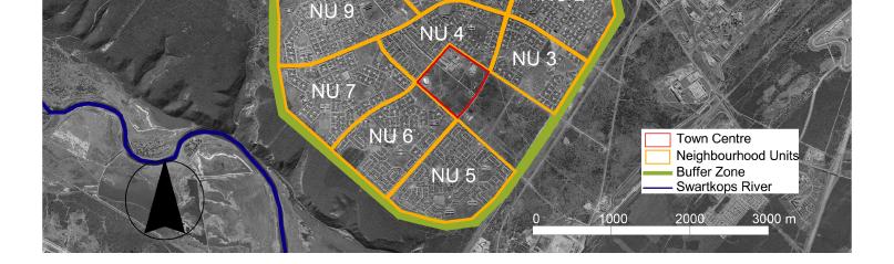
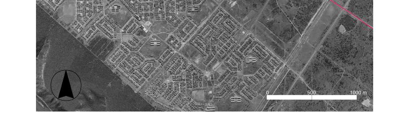
12 Aim and objectives The overall aim of our study is to make a plan of how to develop the vacant land around Motherwell Town Centre and existing Neighbourhood Unit 5 and 6. Our main focus is on means to develop proposals in order to increase density, improve accessibility within the area and to surroundings, improve the conditions for pedestrians and create well defined usable public spaces. In Motherwell there is plenty of vacant land offering a development potential to be used as residential areas, providing a mix of different housing typologies and public spaces of high quality. The proposal aims to support the transformation from a typical apartheid suburb into a neighbourhood with good living conditions. Vacant land close to the Town Centre 12


13 13 Map 3.
14 Method We started our project by three months of field work in Port Elizabeth, South Africa. The first week we got an overall understanding of the contrasts in standard of living in different residential areas. We met town planners from the municipality, architects and others involved in the development of Motherwell. They described the current planning situation, their visions for the future and gave us necessary policy documents and maps regarding Motherwell and the Metropolitan as a whole. Our main focus during the stay in South Africa was to experience Motherwell as a whole and document our project area at a more detailed level. Mostly we walked around taking notes and pictures, to document the project area, to register how pedestrians move within the area and how people use public space. We visited the area during both day time and night time to see the differences in street life. We were also interested to see how much the high mast lighting and the few conventional street lights light up the area. On our walks we met a lot of residents and took the opportunity to interview them; it was mainly informal meetings that occurred on the streets, these meetings gave us a feeling of their views and thoughts about the area. To analyse the project area and also its connection to the rest of Motherwell, we have chosen to use the Space syntax analysis made by consultants for the municipality. We have also made two analyses of our own, based on the methods of the City Structure Analysis by Kevin Lynch and the SWOT analyse method. The Kevin Lynch analysis helped us to sort out the features of the area. The analysis Motherwell today was based on the SWOT method and used as a help to analyse the current situation in Motherwell. Based on our inventory and analysis we propose three Guiding Principles; accessibility, densification and public space for public use. As a theoretical background for our discussion about public space we have used the book Life between buildings by Jan Gehl. Planning principles from the Sustainable Communities Project, proposals and principles from the Masterplan for Motherwell Urban Renewal Programme have been used as a foundation for our proposal. Before we left South Africa we made a presentation for town planners and consultants involved in the development of Motherwell. We presented our basic planning concepts, analysis of the area and our structural proposal of how to develop the project area (NU 5, NU 6 and vacant land close to the town centre). This occasion gave us feedback, which we have considered in our further work with our proposals. Back in Sweden we continued to compile the report and our individual parts of the project, which constitute more detailed proposals of how to develop nodes and high density residential on vacant land. 14


15 Driving around in project area Documenting the project area D O C U ME N T I N G M O T H E R W E L L Interview residents 15 Taking a shortcut
16 16


17 17 BACKGROUND


18 South Africa is a land of contrasts; a middle income country according to Swedish International Development cooperation Agency but so far is it only a minority of the population that has the living standard you can expect from a developed country. 1 Most people are poor and lives in suburbs, so called townships, in the outskirts of the cities, Port Elizabeth is no exception. Port Elizabeth Port Elizabeth is the fifth largest city in the country and the major city in Nelson Mandela Metropolitan Municipality, which consists of three urban areas, Uitenhage, Despatch and Port Elizabeth. The city has one of the most important harbours in the country; it dates back to early 19 th century. Port Elizabeth has a beautiful location by the Indian Ocean, with some of South Africa s best beaches. Govan Mbeki Street, Port Elizabeth (Dahlgren Carolin 2005) The population today is estimated to be 1 million inhabitants, but it is growing fast. Nelson Mandela Metropolitan Municipality has a huge housing backlog, many people move from the countryside into the rapidly growing suburbs outside the city. It is a segregated city where the class distinctions are obvious through the various standards of living which appears in different parts of the city. 1 SIDA, varför ger Sverige bistånd? View over Port Elizabeth and Indian Ocean


19 Apartheid city South Africa has a history of segregation of the different ethnic groups within the population, during almost all of the 20 th century. The apartheid system divided the population into different groups after the colour of their skin. For the nonwhite population this meant to be discriminated in all aspects of life. Different groups should not interact, and therefore stay in separate areas. These ideas had and still have a big impact on the spatial structure of South African cities. One of the first steps towards institutionalising separate development came in the early 20 th century, with a legislation that limited the black population s right to own or lease land. During the time period after the First World War the state also initiated housing schemes, which provided further means to implement racial segregation on an urban level between different population groups. 2 In 1948 the National Party gained political power and began the formalization of apartheid ideology, that is the separation between whites, africans, indians and coloureds. The apartheid laws limited the rights for non-whites to work and move within the city without permission. The city centres had a mixed population but where demolished and the non white population was removed to newly built locations, so called townships. 3 A shack Housing extreme 2 Lind, E. (2003). 3 Nationalencyklopedin (2006). 19
20 The townships where located far away from the white city as a way of minimizing the interaction between the different racial groups. The goal was to control the population and the physical structure of the townships was an outcome of this. Townships where surrounded by a buffer zone of undeveloped land with few access roads connected to the city centre. Motherwell was planned during the 1970s when the Greater Algoa Bay Planning Authority saw a need for a new black residential area. The area was being located on the north side of the Swartkops River (see map 4 page 21) for squatter families living in shacks. During the 1980s Motherwell was established and became the largest residential area for black people in Port Elizabeth. 4 The planning of Motherwell had to conform to the legislation at the time, which prescribed; - Provision of a buffer zone of between 150m 270m around Motherwell, which was to be left undeveloped, for maximum control. - Provision of a town centre. All needs of the residents should be provided within Motherwell, to eliminate the needs to commute to and thus interact with, other areas. It was becoming more obvious that the policy of treating black people as temporary urban dwellers in the city was no longer sustainable. That is why Algoa Bay Guide Plan Committee emphasized the proposed new settlement to be fully planned and provided with a range of facilities, within the community. Motherwell was one of the first areas, which incorporated other functions than only residential, for example a shopping centre. The intention was for the township to be a selfcontained unit. 5 A Masterplan for the development of Motherwell was approved in This was to be used as a guide for the development of a new suburb; Motherwell was estimated to accommodate approximately people when fully developed, in nine Neighbourhood Units. The Masterplan proposed mixed housing types for people in different stages in the life cycle. Despite this, almost all of the residential built in Motherwell is small detached one storey houses, as usual in most townships. The Masterplan recognized that the black population was not a homogenous group. There where people with different levels of incomes, education and social classes. Thus Neighbourhood Unit 5 and Neighbourhood Unit 6 were built for high income earners. 6 4 Nelson Mandela Metropolitan Municipality (2004). Masterplan for MURP. 5 Nelson Mandela Metropolitan Municipality (2004). Masterplan for MURP. 6 Nelson Mandela Metropolitan Municipality (2004). Masterplan for MURP. 20

21 21 Map 4.

22 After 1990 In the 1990s the National Party initiated the democratic transformation in South Africa after a shift of leadership. The apartheid state had been unmanageable in many ways, because of economic stagnation, amounting national opposition from civic and political organisations as well as sanctions by the international community. 7 Apartheid was abolished and a new era began. Nelson Mandela was released from prison One of his first speeches was held in Motherwell for thousands of people. Motherwell Township has grown to accommodate approximately inhabitants. All of the Neighbourhood Units from the original Masterplan have been built today. Since 1980s Motherwell has been extended in the north by four new residential areas, and two new Neighbourhood Units are under construction. Many of the facilities proposed in the Masterplan 1981 were never realized, or only partly developed, for example the Town Centre, but land was reserved for this purpose. This is why Motherwell has a lot of vacant land today. 8 poor public transportations makes it difficult for the township to develop. The spatial structure restrains people to interact within the area and the city of Port Elizabeth. Prisoners released from Robben Island, a start of a new democratic era Still, despite the abolition of apartheid, the township is isolated and poorly integrated with the rest of the city. Few access roads, only one bridge crossing Swartkops River and 7 Lind, E. (2003). 8 Nelson Mandela Metropolitan Municipality (2004). Masterpaln for MURP. 22

23 23 Map 5.
24 24
25 MUNICIPAL PLANNING GUIDELINES 25

26 Below we shortly summarize the two most important policy documents that have been the basis for our plan proposal; Motherwell Urban Renewal Master Plan and Sustainable Communities Project. Motherwell Urban Renewal Programme A Masterplan has been developed for Nelson Mandela Metropolitan Municipality by consultants Matrix and Metroplan. It is a part of the Urban Renewal Programme and sets the overall framework for the future development in Motherwell, socially, economically and spatially. Five important principles for the spatial development are presented. a one tourist/multifunctional corridor that serves the whole of Motherwell and at last a green edge corridor along Swartskops River. Create a grid between these corridors (see figure 1 below). 3. Urban structure; create a more urban structure with higher densities along the streets, to define a streetscape. 4. Transportation; create better conditions for pedestrians to walk safely within the area and more efficient public transportations. 5. Better facilities; social services can be placed in a cluster. Increase accessibility by location. 1. Densification; undeveloped spaces can be developed as residential areas. In order to create a critical mass, to make it possible to provide a higher level of service and facilities. Densities should be increased from the current 19 units/hectare to above 30 units/hectare in Motherwell as a whole (see map 13 page 48). 2. Integration; create better accessibility between Motherwell and the rest of the city. Develop three activity corridors. Tyinira Street as a central high density corridor, with mixed use activities such as housing, commercial and transportation; Addo road as Fig. 1. Activity corridors (NMMM 2004) 26
27 Sustainable Communities Project Sustainable communities project is an overall planning concept that will be used when finalized in 2006 by Nelson Mandela Metropolitan Municipality as a complement to other planning instruments such as the Integrated Development Plan and Comprehensive Urban Plan. The goal with this planning concept is to achieve a more balanced urban structure based on integration and sustainability and to present ways of how this can be done. 9 Sense of togetherness requires community involvement. Safety and security is supported by physical design in housing areas, street patterns and pedestrian walkways. Local economic development provides employment and income within the community and is a basis for local service provision. We find the following principles relevant to apply in Motherwell; Important elements in the physical structure of a sustainable community are; Mixed development to promote functional integration and improve accessibility. Higher densities to create a more compact city with more efficient public transport, better use of infrastructure at lower costs and contribute to long term sustainability. Variation and flexibility to improve the image of a community and allow socio-economic integration. 9 Nelson Mandela Metropolitan Municipality (draft report). Sustainable Housing clusters; several housing types in small units and a varied urban environment. This promotes safety and a sense of togetherness. Neighbourhood units; good access to basic services, commercial, recreational, social and cultural facilities. Alternative economic activities and marketing of local produce. Central nodes; mixed use. High density housing development, higher order commercial as social, Communities project. 27
28 municipal, community services, business support centre and public transport node. Activity corridor; mixed development and mixed uses. Varied housing development with high density. Flexible land use provision, informal to formal establishments. Good access for pedestrians. Fig. 2. Illustrates the maximum convenient walking distance of 2 kilometres, according to Sustainable Communities Concept. The distance depends on the existing conditions and the physical structure, with higher densities the distances could be shorter. The estimated size of a Sustainable Community would be at a minimum people. 10 Public transport corridors; an efficient bus system connecting the sections of the community to the main employment areas and main centres; co-ordinated with local feeder buses or taxi-routes and with links to the main walkways. Pedestrian walkways; with direct access to neighbourhood centres and other important facilities within the neighbourhood; designed for a safety and a pleasant use. Business Parks and Support Centres; to support and develop the local economic. These should be located near main centres and transport nodes. Public open space; a hierarchy of open space within the housing cluster, neighbourhood and community level; safe and convenient pedestrian access to open space. 10 Nelson Mandela Metropolitan Municipality (draft report). Sustainable Communities Project. 28
29 Fig. 2. Maximum convenient walking distance (Larsson, S. (Power Point Presentation) 29


30 Ongoing projects in Motherwell The projects described below are either presently being built or under construction. Sakhuluntu Village The Sakhuluntu Village will consist of 112 houses and 93 rental apartments. At present, ten houses have been built as show houses in a housing exhibition. Sakhuluntu Village covers an area of two hectares, this gives a gross density of approximately 100 units per hectare (compare with maps on page 48), and it consists of semi-detached one storey units, double storey semi-detached and double storey row houses. 11 Sakhuluntu Imizi The Imizi Social Housing Project consists of 230 rental units in eight blocks. The area comprises approximately three hectare, this gives a gross density of 77 units per hectare (compare with maps on page 48). The housing stock comprises singleroom units, two-bedroom units and three-bedroom units. The two- and three-bedroom units are double storeys and the oneroom units are placed in a building of three floors Handout, Sakhuluntu Housing Exhibition A model of the Imizi Social Housing Project 12 Expo, Nelson Mandela Metro. 30

31 31 Map 6.


32 Nelson Mandela Peace Park When Nelson Mandela was released from prison in 1994, he held one of his first speeches in Motherwell. As a memory of this occasion a park will be developed on the vacant piece of land in Neighbourhood Unit 3 where the speech was held. At present the park is under construction but the visions for the park are that it will be a park for the whole community such as St. George s Park in Central, which provides several recreational activities. The park will hopefully also be a tourist attraction, which brings foreign people and others to Motherwell. 13 Nelson Mandela Peace Park today 13 Nelson Mandela Metropolitan Municipality (2004). Masterplan for MURP. St. George s Park 32

33 Kuhlani corridor Khulani corridor is a proposed public transportation link with a feeder bus system. It envisages movement from the employment area Korsten via the township KwaZakhele to Motherwell Town Centre. Along the corridor there will bee a series of pick-up and drop of points. The aim is to reverse the current one-directional movement pattern of public transport. 14 Parts of this transportation corridor are presently being built. Map 7. Khulani corridor (NMMM 2004) 14 Nelson Mandela Metropolitan Municipality (2004). Masterplan for MURP. 33
The Big Hole Precinct
 Development of The Big Hole Precinct in Kimberley South Africa A Minor Field Study Department of Spatial Planning, Blekinge Institute of Technology, 2005 Supervisors professor Anita Larsson and Mr Gerhard
Metropolitan Context BACKGROUND
 Metropolitan Context BACKGROUND 110 Erik Telldén, Stockholm 2010. Photos and maps are made by the author if nothing else is mentioned. Areal plans and photos are provided by and published with the permission
TOWNSHIP REPLANNING: THE CASE OF INK CASE STUDY
 TOWNSHIP REPLANNING: THE CASE OF INK CASE STUDY OVERVIEW Background Origins of the INK project Local context Problem statement Intervention logic City scale spatial planning context Results Lessons learned
Official Plan Review: Draft Built Form Policies
 PG.30.1 REPORT FOR ACTION Official Plan Review: Draft Built Form Policies Date: May 15, 2018 To: Planning and Growth Management Committee From: Chief Planner and Executive Director, City Planning Division
WELCOME. Land North of STEVENAGE. We would like to thank you for attending our public exhibition today.
 WELCOME We would like to thank you for attending our public exhibition today. The purpose of this event is to share our proposals and hear your thoughts on our ideas. Members of the project team are on
PART 5: DEVELOPMENT FRAMEWORK Figure 57: Proposed Height
 Figure 57: Proposed Height 103 Figure 58: Proposed Land Use 104 Figure 59: 3D Image of the Initial Height and Land Use in the Study Area 105 4.3.2 Landmarks and Nodes The growth of Sandton from an out
UDF PLANS AND GUIDELINES
 UDF PLANS AND GUIDELINES 5 Land Use Land Use Development Plan Plan no. 3 Land Use Development Mixed Use Retail / Leisure Residential Civic and Institutional Proposed Zoning Table Development Edges Plan
MODULE 3 RESTRUCTURING THE ENVIRONMENT
 MODULE 3 RESTRUCTURING THE TOWNSHIP PHYSICAL ENVIRONMENT FOCUS OF THE MODULE The physical and spatial (locational) characteristics that prevent townships from developing Levels of intervention: Things
KEY ISSUES W.R.T. URBAN PLANNING GUIDELINES
 Land and Poverty Conference 2017: Responsible Land Governance - Towards an Evidence-Based Approach Source: Javier Mozas, Aurora Fernandez Per (2006), Density: New Collective Housing; UNHabitat 2013 NATIONAL-LEVEL
URBAN DESIGN BRIEF URBAN DESIGN BRIEF 721 FRANKLIN BLVD, CAMBRIDGE August 2018
 URBAN DESIGN BRIEF URBAN DESIGN BRIEF 721 FRANKLIN BLVD, CAMBRIDGE August 2018 DESIGN BRIEF CONTENTS PART A 1.0 INTRODUCTION 2.0 DESCRIPTION & ANALYSIS OF SITE CONTEXT 3.0 DESIGN CONSTRAINTS AND OPPORTUNITIES
Official Plan Review
 Official Plan Review Summary Report - The Built Environment August 2014 Part 1: Introduction Planning for a healthy, prosperous and sustainable community is an important goal for our municipality. From
Outline of Presentation
 LUSAKA CITY COUNCIL 2 nd Annual IGC Cities Conference Making Cities work for growth London School of Economics (LSE) United Kingdom. 28 th 29 th January 2016 Presenter: Alex Mwansa Town Clerk Lusaka City
14.5 HOPEFIELD: (REFER PLAN 39 AND PLAN 40)
") URBAN DYNAMICS WESTERN CAPE INC. 248 14.5 HOPEFIELD: (REFER PLAN 39 AND PLAN 40) FIGURE 83: LOCALITY - HOPEFIELD Within the context of the Saldanha Bay Municipal area, Hopefield, an historical agricultural
URBAN DYNAMICS WESTERN CAPE INC. 248 14.5 HOPEFIELD: (REFER PLAN 39 AND PLAN 40) FIGURE 83: LOCALITY - HOPEFIELD Within the context of the Saldanha Bay Municipal area, Hopefield, an historical agricultural
1.0 Purpose of a Secondary Plan for the Masonville Transit Village
 Report to Planning and Environment Committee To: Chair and Members Planning & Environment Committee From: John M. Fleming Managing Director, Planning and City Planner Subject: Masonville Transit Village
RIGA LATVIA. KEY FEATURES OF THE CITY Demographic Facts. Urban Figures. Heritage. EXISTING GOVERNANCE MECHANISMS Development and Management Plans
 RIGA LATVIA KEY FEATURES OF THE CITY Demographic Facts around 700.000 inhabitants in the city 1.15 million people in the Riga region Urban Figures the medieval core of the Old Town the 19th century grid
Northern Territory Compact Urban Growth Policy
 Northern Territory Compact Urban Growth Policy A Reference Policy Document to clause 2.7 (Reference to Policy) of the NT Planning Scheme May 2015 Table of Contents 1 Policy Setting... 3 1.1 Context for
Cooperative Research in Water Management
 Proceedings of the 8 th International Conference on Applied Informatics Eger, Hungary, January 27 30, 2010. Vol. 1. pp. 273 281. Cooperative Research in Water Management Margit Horosz-Gulyás, Katalin Katonáné
1Planning. Approach. Part I Chapter 1: Planning Approach
 1Planning Approach Part I Chapter 1: Planning Approach 1 Planning Approach page 5 1Planning Approach The preparation of the Master Plan constitutes a unique opportunity to reflect collectively on the
13 THORNHILL YONGE STREET STUDY IMPLEMENTATION CITY OF VAUGHAN OPA 669 AND TOWN OF MARKHAM OPA 154
 13 THORNHILL YONGE STREET STUDY IMPLEMENTATION CITY OF VAUGHAN OPA 669 AND TOWN OF MARKHAM OPA 154 The Planning and Economic Development Committee recommends the adoption of the recommendations contained
Commercial, Retail and Tourism Executive Summary December 2018
 Town of Wasaga Beach Official Plan Review, Retail and Executive Summary December 2018 1 An Official Plan directs where and how to grow The preparation of a new Official Plan for Wasaga Beach is an opportunity
Colchester Northern Gateway Master Plan Vision Review Draft. July 2016
 Colchester Northern Gateway Master Plan Vision Review Draft July 2016 Contents Introduction 4 Context 8 Purpose of the Report 8 Strategic Position 9 Overview of the Process 11 2012 Master Plan Vision 12
Welcome to our public exhibition
 About our development Welcome to our public exhibition This exhibition gives you the chance to view and comment on our proposals for a new residential development of 165 high-quality homes, along with
Public Open House #1
 Public Open House #1 TONIGHT S AGENDA Welcome Project Overview The Big Picture The Station Area The Analysis Thoughts about Future Change Breakout Group Discussions Summation / Next Steps Project Overview
DAREBIN PLANNING SCHEME AMENDMENT C137
 Who is the planning authority? Planning and Environment Act 1987 DAREBIN PLANNING SCHEME AMENDMENT C137 EXPLANATORY REPORT This amendment has been prepared by the Darebin City Council, who is the planning
ONTARIO MUNICIPAL BOARD
 PL 120483 ONTARIO MUNICIPAL BOARD Applicant/Appellant: 2124123 Ontario Limited Subject: OPA, Rezoning and Draft Plan of Subdivision Municipal Address: 3940 Highway 7 East Municipality: City of Markham
PUBLIC REALM STRATEGY
 CONSULTATION DRAFT PUBLIC REALM STRATEGY Trenchard Street & Frogmore Street City Design Group Place Directorate Public Realm Strategy Trenchard Street & Frogmore Street Contents 1. Introduction 2. Understanding
AMENDMENT NO.XX TO THE CLARINGTON OFFICIAL PLAN
 AMENDMENT NO.XX TO THE CLARINGTON OFFICIAL PLAN PURPOSE: The purpose of this Amendment is to create a planning framework that will facilitate the development of a transit supportive, pedestrian friendly,
HARDWICK GREEN, King s Lynn. Welcome to our Exhibition. What are your views? Introduction to the site and proposals. About us
 HARDWICK GREE, King s Lynn Welcome to our Exhibition Welcome to our exhibition, which is being held to provide you with the opportunity to understand and comment upon our proposals for new residential
PUBLIC OPEN HOUSE HURONTARIO-MAIN CORRIDOR SECONDARY PLAN
 PUBLIC OPEN HOUSE HURONTARIO-MAIN CORRIDOR SECONDARY PLAN Tuesday, February 28, 2012 6pm 9pm 1 st Floor Atrium, City Hall 2 Wellington Street West, Brampton 1 POLICY FRAMEWORK The 2006 Provincial Growth
A Growing Community Rural Settlement Areas
 Town of Huntsville Official Plan Review - POLICY BACKGROUND PAPER A Growing Community Rural Settlement Areas BACKGROUND: In addition to the fully municipally-serviced Urban Settlement Area and the Hidden
Further input invited as Colchester Growth Strategy nears final phase
 IUE 3 / NOVEMBER 2015 Further input invited as Colchester Growth trategy nears final phase trathcona County is seeking public feedback as it enters the final phase of work on a Growth Management trategy
Trafalgar Road Corridor Planning Study Open House
 Trafalgar Road Corridor Planning Study Open House June 24, 2013 6:30-8:30 p.m. Oakville & Trafalgar Rooms Overview The Livable Oakville Plan identifies the lands along Trafalgar Road, between the QEW and
ADMINISTRATION RECOMMENDATION(S) 2018 January 25. That Calgary Planning Commission recommend APPROVAL of the proposed Land Use Amendment.
 2018 January 25. That Calgary Planning Commission recommend APPROVAL of the proposed Land Use Amendment.") Page 1 of 9 EXECUTIVE SUMMARY This land use amendment proposes to redesignate a parcel from DC Direct Control District to Multi-Residential Contextual Grade-Oriented (M-CG) District to allow for multi-residential
Page 1 of 9 EXECUTIVE SUMMARY This land use amendment proposes to redesignate a parcel from DC Direct Control District to Multi-Residential Contextual Grade-Oriented (M-CG) District to allow for multi-residential
Complete Neighbourhood Guidelines Review Tool
 Complete Neighbourhood Guidelines Review Tool Prepared By: City of Regina Planning Department October 2014 Page 1 of 14 Community Development Review Checklist for Secondary Plans and Concept Plans The
Case Study of Integrated Housing and Railway Development (Kohoku New Town and Yokohama City Metro Development)
") Case Study of Integrated Housing and Railway Development (Kohoku New Town and Yokohama City Metro Development) Project Division, Urban Development Bureau and Development Cooperation Division, International
Case Study of Integrated Housing and Railway Development (Kohoku New Town and Yokohama City Metro Development) Project Division, Urban Development Bureau and Development Cooperation Division, International
Newcourt Masterplan. November Exeter Local Development Framework
 Newcourt Masterplan November 2010 Exeter Local Development Framework Background The Exeter Core Strategy Proposed Submission sets out the vision, objectives and strategy for the development of Exeter up
10/19/2016. Chapter 22 Lecture Outline Urbanization. Urbanization and Sustainable Cities. Outline
 Chapter 22 Lecture Outline Urbanization 1 Urbanization and Sustainable Cities 2 Outline Urbanization Push and Pull Factors Urban Challenges in the Developing World Urban Challenges in the Developed World
ARLINGTON COUNTY, VIRGINIA
 ARLINGTON COUNTY, VIRGINIA County Board Agenda Item Meeting October 15, 2005 DATE: September 28, 2005 SUBJECT: Request to Advertise the adoption of the 2005 Clarendon Sector Plan C. M. RECOMMENDATION:
20 & 30 Frank Nighbor Place
 Engineering Land / Site Development Municipal Infrastructure Environmental / Water Resources Traffic / Transportation Structural Recreational Planning Land / Site Development Planning Application Management
Tauranga City Centre Spatial Framework
 Tauranga City Centre Spatial Framework Stakeholder Engagement Workshop 15 October 2015 Project Design Team Beca & LandLAB Our team Henry Crothers (LandLab) Landscape Architect/Urban Designer Urban and
ACUPUNCTURAL ARCHITECTURE IN BURAIL
 ACUPUNCTURAL ARCHITECTURE IN BURAIL ADDITIONAL BOOKLET 2013 / 2014 Naisa Al Kailany, Mania Bien, Floor Brinks, Hans Kalkhoven REFLECTION GENERAL INFORMATION BURAIL Area of the Plot Permanent cluster 400
Urban planning and Public Transport
 Urban planning and Public Transport MOJCA SASEK DIVJAK Urban Planning Institute of the Republic of Slovenia Trnovski pristan 2, 1000 Ljubljana SLOVENIA e-mail: mojca.sasek@uirs.si; http://www.uirs.si Abstract:
K. SMART ASSOCIATES LIMITED
 Planning Justification Report Zoning By-Law Amendment 185 King Street North Waterloo, Ontario April 7th, 2017 Project Reference Number 16-245 K. SMART ASSOCIATES LIMITED CONSULTING ENGINEERS AND PLANNERS
Chapter 2: OUTLINE PLANNING APPLICATION PROPOSALS. A New Garden Neighbourhood Matford Barton 17
 Chapter 2: OUTLINE PLANNING APPLICATION PROPOSALS A New Garden Neighbourhood Matford Barton 17 2.1. SUMMARY AND STATUS OF THE PROPOSALS 2.1.1. The parameter plans and associated wording in this chapter
Project Profile BAR HARBOR
 1 BAR HARBOR The Bar Harbor Master Plan merges community vision with design guidelines to preserve the unique character of Bar Harbor Village. PROJECT SUMMARY Overview: The economic vitality of Bar Harbor
SECTION ONE: INTRODUCTION. introduction
 introduction 1 INTRODUCTION Since it was first established in 1843 as a trading post for the Hudson s Bay Company, Victoria has evolved into a Provincial capital city that is recognized across Canada and
YONGE STEELES CORRIDOR SECONDARY PLAN. Young + Wright / IBI Group Architects Dillon Consulting Ltd. GHK International (Canada) Ltd.
 Ltd.") PART A: PREAMBLE 1.0 PURPOSE The purpose of this Secondary Plan is to provide a development framework for intensification of the Yonge/ Steeles corridor including the north side of Steeles Avenue West
PART A: PREAMBLE 1.0 PURPOSE The purpose of this Secondary Plan is to provide a development framework for intensification of the Yonge/ Steeles corridor including the north side of Steeles Avenue West
burlington mobility hubs study Downtown Burlington Mobility Hub
 burlington mobility hubs study Downtown Burlington Mobility Hub Draft Precinct Plan Workbook PIC #3, September 7, 2017 downtown mobility hub objectives City staff and their consultants are proposing an
Chapter 2: Vision, Goals and Strategies
 Chapter 2: Vision, Goals and Lake Elmo Today & Tomorrow Comprehensive Plan 2040 2 VISION, GOALS & STRATEGIES - DRAFT 4-6-2018 INTRODUCTION Comprehensive Plan Purpose Perhapse the most important objective
Design Guidance. Introduction, Approach and Design Principles. Mauritius. November Ministry of Housing and Lands. .. a
 sig evelo r D Mauritius s. Utilities.. Individu a s. er itects.to ls chpers.po e Public. T. h rban D Sc U e me Promot e h ners. A Design Guidance o.h Planne rs n w iticians r l useholde National Development
PLACE WORKSHOP REPORT. A+DS SNH sustainable placemaking programme
 PLACE briefing WORKSHOP REPORT A+DS SNH sustainable placemaking programme INTRODUCTION This report summarises the outcome of a Scottish Natural Heritage workshop on placemaking which was held on Wednesday
Mark-up of the effect of the proposed Bronte Village Growth Area OPA No.18 on the text of section 24, Bronte Village, of the Livable Oakville Plan
 Mark-up of the effect of the proposed Bronte Village Growth Area OPA No.18 on the text of section 24, Bronte Village, of the Livable Oakville Plan Notes: This document is provided for information purposes
East Bayshore Road Neighbourhood
 East Bayshore Road Neighbourhood Northridge Property Management Urban Design Brief 3195 East Bayshore Road City of Owen Sound January 2016 East Bayshore Road Neighbourhood Northridge Property Management
URBAN DESIGN BRIEF. 2136&2148 Trafalgar Road. Town of Oakville
 URBAN DESIGN BRIEF 2136&2148 Trafalgar Road Town of Oakville Prepared By: METROPOLITAN CONSULTING INC For 2500674 Ontario Inc November 2016 TABLE OF CONTENTS Page No. 1.0 Introduction/Description of Subject
URBAN DESIGN, ARCHITECTURE & PLANNING PLANNING FOR A BETTER OUTCOME
 URBAN DESIGN, ARCHITECTURE & PLANNING PLANNING FOR A BETTER OUTCOME PETER EGERTON DISCIPLINE LEAD URBAN DESIGN February 2018 DEMYSTIFYING URBAN DESIGN WHAT IS URBAN DESIGN Surveyors created the towns Engineers
WELCOME TO THE NEW WILTON PARK
 WELCOME TO THE NEW WILTON PARK VISION HISTORY OF WILTON PARK TOWARDS A PLANNING APPLICATION Our objective is to create a truly outstanding environment at Wilton Park. At the heart of our proposals is a
Field trip report. Field trip transport planning, , 2 ECTS, 2017S
 Field trip report Field trip transport planning, 231.043, 2 ECTS, 2017S Transit-Oriented Development (TOD) initiated by private railway companies in Japan The example of Utsukushigaoka on the Tama Den-en
St. Lawrence Neighbourhood Focused Area - Official Plan Amendment Status Report
 STAFF REPORT ACTION REQUIRED St. Lawrence Neighbourhood Focused Area - Official Plan Amendment Status Report Date: May 21, 2015 To: From: Wards: Reference Number: Toronto and East York Community Council
Recent UN and EU Sustainable Development Policies (Post 2015): What challenges for city planning and governance
: What challenges for city planning and governance") Recent UN and EU Sustainable Development Policies (Post 2015): What challenges for city planning and governance Europe at a crossroads: the challenge for future sustainable development 20 July 2016 Roudaina
Recent UN and EU Sustainable Development Policies (Post 2015): What challenges for city planning and governance Europe at a crossroads: the challenge for future sustainable development 20 July 2016 Roudaina
Urban Growth Management in Seven New World cities: Aligning visions and quality neighbourhood outcomes
 Urban Growth Management in Seven New World cities: Aligning visions and quality neighbourhood outcomes New Zealand Centre for Sustainable Cities 14 August 2013 Errol Haarhoff & Lee Beattie School of Architecture
Tel: (705) Fax: (705)
 Fax: (705)") 521 and 525 Essa Road City of Barrie Tel: (705) 812-3281 Fax: (705) 812-3438 Email: INFO@IPSCONSULTINGINC.com 1 5 0 D U N L O P S T R E E T E A S T, S U I T E 2 0 1, B A R R I E O N T A R I O L 4 M 1 B
521 and 525 Essa Road City of Barrie Tel: (705) 812-3281 Fax: (705) 812-3438 Email: INFO@IPSCONSULTINGINC.com 1 5 0 D U N L O P S T R E E T E A S T, S U I T E 2 0 1, B A R R I E O N T A R I O L 4 M 1 B
Welcome to the Queen s Square, Croydon Consultation
 Welcome to the Queen s Square, Croydon Consultation 02 PARK STREET 1-27 ST GEORGE S WALK 03 05 04 06 01 Croydon Town Hall The Queen s Gardens Thank you for coming to the public consultation about our proposed
CONTENTS 8.0 LAND USE 8.1 GENERAL LAND USE 8.2 RESIDENTIAL 8.3 MIXED USE 8.4 COMMERCIAL 8.5 EMPLOYMENT LANDS
 8-2 Land Use 8.0 LAND USE CONTENTS 8.1 GENERAL LAND USE 8.1.1 Uses provided for in all Land Use Designations 8.1.2 Uses prohibited in Hazardous Lands, Hazardous Sites and Special Policy Areas 8.1.3 Uses
Public may provide comments on the GDP within the next two weeks (December 24)
") 25/70 General Development Plan (GDP) Public Meeting Wednesday, December 10, 2014 6:00 8:00 P.M. District 1 Police Station Community Room 1311 W 46th Ave, Denver, CO 80211 Council Woman Montero: This particular
25/70 General Development Plan (GDP) Public Meeting Wednesday, December 10, 2014 6:00 8:00 P.M. District 1 Police Station Community Room 1311 W 46th Ave, Denver, CO 80211 Council Woman Montero: This particular
ROAD ACCESS MANAGEMENT IN PRACTICE: THE PORT ELIZABETH CASE
 ROAD ACCESS MANAGEMENT IN PRACTICE: THE PORT ELIZABETH CASE C. J. HOLDERNESS and H. J. STANDER* Khuthele Projects (Pty) Ltd, F02, Rostra, The Forum, Century City, 7441 *BKS (Pty) Ltd, P O Box 112, Bellville,
WELCOME GYPSY LANE. Wider Site Location plan. Proposals for the development of LAND OFF FOXLYDIATE LANE WEBHEATH. Proposals for the development of
 WELCOME The developers are preparing an outline planning application for a residential led development and need the community s views in order to develop the proposals further WHAT IS PROPOSED? A high
1.0 PLANNING MARKHAM S FUTURE CONTENTS
 1-1 Planning Markham s Future 1.0 PLANNING MARKHAM S FUTURE CONTENTS 1.1 THE PURPOSE OF THE OFFICIAL PLAN 1.2 THE MARKHAM CONTEXT 1.3 THE REGULATORY CONTEXT 1.3.1 Province of Ontario 1.3.2 York Region
Urban Design Brief. Watson Parkway North & Watson Road North Guelph, Ontario. Prepared by Coletara Development
 Urban Design Brief Watson Parkway North & Watson Road North Guelph, Ontario Prepared by Coletara Development December, 2013 Urban Design Brief, Coletara Development 1 Introduction This Urban Design Brief
Cannards Grave Road Shepton Mallet Design Workshop 1 st June2016
 Cannards Grave Road Shepton Mallet Design Workshop 1 st June2016 Overview Start of a process: Looking at the land south of the town, to the west of Cannards Grave Road as identified in the Local Plan.
393, 395, 397, 399, 401 and 403 Spring Garden Avenue Official Plan and Zoning By-law Amendment Application Preliminary Report
 STAFF REPORT ACTION REQUIRED 393, 395, 397, 399, 401 and 403 Spring Garden Avenue Official Plan and Zoning By-law Amendment Application Preliminary Report Date: March 29, 2010 To: From: Wards: Reference
URBAN DESIGN BRIEF 181 Burloak Drive, Oakville
 URBAN DESIGN BRIEF 181 Burloak Drive, Oakville February 2017 Our File: 1730B 230-7050 WESTON ROAD / WOODBRIDGE / ONTARIO / L4L 8G7 / T: 905 761 5588/ F: 905 761 5589/WWW.MHBCPLAN.COM TABLE OF CONTENTS
Attachment 1 TOWN OF NEW TECUMSETH. Manual for the Preparation of an Urban Design Report
 Attachment 1 TOWN OF NEW TECUMSETH Manual for the Preparation of an Urban Design Report July 2010 TABLE OF CONTENTS Background, Policy Framework and the Preparation of Urban Design Reports 1. Introduction
Welcome. Proposals for land at Smug Oak Lane BRICKET WOOD
 Proposals for land at Smug Oak Lane BRICKET WOOD Previous Linden Homes and Wates Developments scheme Welcome Welcome to Linden Homes and Wates Developments public exhibition. Working together as joint
THAT the attached Terms of Reference for the Thornhill Centre Street Study be approved.
 COMMITTEE OF THE WHOLE AUGUST 18, 2003 THORNHILL CENTRE STREET STUDY PLANNING FILE: 15.92 Recommendation The Commissioner of Planning recommends: THAT the attached Terms of Reference for the Thornhill
MAYFIELD WEST SECONDARY PLAN PHASE 2
 MAYFIELD WEST SECONDARY PLAN PHASE 2 Public Open House #3 February 25, 2010 Draft Preferred Land Use Scenario TOWN OF CALEDON PLANNING & DEVELOPMENT DEPARTMENT Open House Agenda TOWN OF CALEDON 1. Welcome
Development Brief Ursuline Convent, Blackrock, Cork
 Development Brief Ursuline Convent, Blackrock, Cork Comhairle Cathrach Chorcaí Cork City Council 2002 URSULINE CONVENT DEVELOPMENT BRIEF 1 INTRODUCTION AND MAIN OBJECTIVES... 3 1.1 The convent estate is
Settlement Boundaries Methodology North Northumberland Coast Neighbourhood Plan (August 2016)
") Introduction This background paper sets out a methodology for the definition of settlement boundaries in the North Northumberland Coast Neighbourhood Plan. The neighbourhood plan is planning positively
Introduction This background paper sets out a methodology for the definition of settlement boundaries in the North Northumberland Coast Neighbourhood Plan. The neighbourhood plan is planning positively
Bloor St. W. Rezoning - Preliminary Report
 STAFF REPORT ACTION REQUIRED 1638-1644 Bloor St. W. Rezoning - Preliminary Report Date: April 1, 2008 To: From: Wards: Reference Number: Toronto and East York Community Council Acting Director, Community
WESTERN ILLINOIS UNIVERSITY
 WESTERN ILLINOIS UNIVERSITY Quad Cities Riverfront Campus Preliminary Master Plan Presentation 2 February 1, 2006 Achieving Future Flexibility 1. Monitor space needs as the new buildings come on line and
City Center Neighborhood Plan
 [1] City Center Neighborhood Plan As adopted by Ordinance No. 2014-09-049 and amended by Ordinance Nos. Formerly CBD Neighborhood as adopted by Ordinance No. 8868 and amended by Ordinance Nos. 8946, 9693,
City of Toronto Official Plan Indicators
 City of Toronto Official Plan Indicators Attachment 1 2017 Gladki Planning Associates in association with Hemson Consulting & Studio Jaywall City of Toronto Official Plan Indicators 1 Introduction What
SOCIO-ECONOMIC MOVEMENT ENVIRONMENT INFRASTRUCTURE TOWN PLANNING
 Table 7: SWOT Analysis SWOT ANALYSIS SOCIO-ECONOMIC MOVEMENT ENVIRONMENT INFRASTRUCTURE TOWN PLANNING STRENGTHS HIGH COMMUTER POPULATION DENSITY MAJORITY OF POPULATION BETWEEN AGE OF 15 & 34 LARGE AVAILABLE
[PLANNING RATIONALE] For Site Plan Control and Lifting of Holding Zone By-Law 101 Champagne Avenue. May 23, 2014
![[PLANNING RATIONALE] For Site Plan Control and Lifting of Holding Zone By-Law 101 Champagne Avenue. May 23, 2014](/thumbs/75/71599615.jpg "[PLANNING RATIONALE] For Site Plan Control and Lifting of Holding Zone By-Law 101 Champagne Avenue. May 23, 2014") [PLANNING RATIONALE] For Site Plan Control and Lifting of Holding Zone By-Law 101 Champagne Avenue May 23, 2014 Contents 1.0 Introduction... 2 2.0 Site Context... 2 2.1 Adjacent Uses... 2 Figure 1: Site
[PLANNING RATIONALE] For Site Plan Control and Lifting of Holding Zone By-Law 101 Champagne Avenue May 23, 2014 Contents 1.0 Introduction... 2 2.0 Site Context... 2 2.1 Adjacent Uses... 2 Figure 1: Site
STUDY OF URBAN SMART GROWTH APPROACH BASED ON THE PRINCIPLES AND GUIDELINES FOR NEW PLANNING
 www.arpapress.com/volumes/vol23issue2/ijrras_23_2_05.pdf STUDY OF URBAN SMART GROWTH APPROACH BASED ON THE PRINCIPLES AND GUIDELINES FOR NEW PLANNING Abbas Matloubi Technical and constructive assistant,
Briefing Document of CNP. June 2017
 Cholsey Parish Council Cholsey Neighbourhood Plan Briefing Document of CNP June 2017 Cholsey Neighbourhood Plan Page! 1 of! 8 Cholsey Plan Briefing v1.4 Page Left Intentionally Blank Cholsey Neighbourhood
6 Growth Management Challenges and Opportunities
 6 Growth Management Challenges and Opportunities The Town has established a goal of attaining a 50% participation rate with respect to employment opportunities versus residential population. The Town s
Greater Langley: NEW BUILDINGS
 District Scale Overview The Liveable Region Strategic Plan (LRSP) identifies four main growth strategies: Protect the green zone; build complete communities; achieve a compact metropolitan area and increase
178 Carruthers Properties Inc.
 178 Carruthers Properties Inc. Planning Rationale for 178 Carruthers Avenue Site Plan Control Application June 2014 Table of Contents 1.0 Introduction 2.0 Overview of Subject Property 3.0 Current Zoning
Transforming Saint John s Urban Heart -
 Transforming Saint John s Urban Heart - How Innovative Community Engagement Inspires a Bold Municipal Plan for a More Sustainable and Compact Saint John 2012 NNECAPA Conference - Brunswick, ME October
Building Better Cities Pyrmont
 Building Better Cities Pyrmont 1 Building Better Cities A fieldwork program for the Stage 6 Geography Urban Places topic focussing on:! Pyrmont - a case study of an inner city suburb undergoing change
Chapter 6: Community Character
 Chapter 6: Community Character The term "community character" covers a broad spectrum of concerns. First and foremost, community character is a visual concept. In Long Grove, however, community character
WHERE DO WE GROW FROM HERE?
 WHERE DO WE GROW FROM HERE? Have your say. HAVE YOUR SAY ON THE NELSON TASMAN FUTURE DEVELOPMENT STRATEGY Nelson and Tasman are growing fast and we continue to need more houses for people to live in, places
INCREMENTAL CHANGE AREA REVIEW March 2015 Page 1
 INCREMENTAL CHANGE AREA REVIEW March 2015 Page 1 Table of Contents Introduction... 3 Background to Review... 3 Comparison of the Schedules to the General Residential Zone... 7 Methodology... 7 Policy Context...
The scale of intervention:
 The scale of intervention: Degree of specificity Is the TND district linked to a specific site? Is it linked to that site s master plan? If more broadly applicable, how will it relate to a variety of sites
FORMER CANADIAN FORCES BASE (CFB) ROCKCLIFFE SECONDARY PLAN. Official Plan Amendment XX to the Official Plan for the City of Ottawa
 ROCKCLIFFE SECONDARY PLAN. Official Plan Amendment XX to the Official Plan for the City of Ottawa") FORMER CANADIAN FORCES BASE (CFB) ROCKCLIFFE SECONDARY PLAN Official Plan Amendment XX to the Official Plan for the City of Ottawa 1 INDEX THE STATEMENT OF COMPONENTS PART A THE PREAMBLE PAGE Purpose...
FORMER CANADIAN FORCES BASE (CFB) ROCKCLIFFE SECONDARY PLAN Official Plan Amendment XX to the Official Plan for the City of Ottawa 1 INDEX THE STATEMENT OF COMPONENTS PART A THE PREAMBLE PAGE Purpose...
2.1 Location and Size
 2.0 Context 7 2.1 Location and Size The Saanich Penninsula The study area is centrally located within the Town boundaries on the east side of Highway 17, which runs through Sidney in a north-south direction.
2.0 Strategic Context 4
 2.0 Strategic Context 4 2.1 The Area Action Plan is a non-statutory plan, which forms a corporate policy document, expressing particular issues and areas of concern while also providing a vision for the
Edward R. Sajecki Commissioner of Planning and Building
 Corporate Report Clerk s Files Originator s Files CD.03.POR DATE: TO: FROM: SUBJECT: Chair and Members of Planning and Development Committee Meeting Date: February 27, 2012 Edward R. Sajecki Commissioner
Draft Western District Plan
 Powered by TCPDF (www.tcpdf.org) Draft Western District Plan Submission_id: 31440 Date of Lodgment: 15 Dec 2017 Origin of Submission: Online Organisation name: Goodman Property Services Australia Pty Ltd
CITY OF MARYLAND HEIGHTS. Mixed-Use
 CITY OF MARYLAND HEIGHTS Mixed-Use BIG IDEA: Mixed-use is a development approach that should be given strong consideration as part of the Comprehensive Plan update, and subsequent amendments to the Zoning