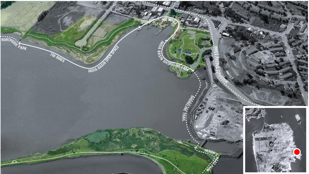
900 Innes & India Basin Shoreline Park
|
|
|
- Cori Whitehead
- 5 years ago
- Views:
Transcription


1
2 India Basin Waterfront Study Task Force A. Philip Randolph Institute Golden Gate Audubon Society Bay Institute Aquarium Foundation Build Inc. Five Points Green Action for Health and Environmental Justice Hunter s Point Family Hunter s Point Shipyard Citizen s Advisory Committee Hunter s View Tenant Association India Basin Neighborhood Association Literacy for Environmental Justice Morgan Heights Tenants Association Office of Community Investment and Infrastructure Office of Economic and Workforce Development Office of Supervisor Malia Cohen Parks PG&E Port of San Francisco Public Housing Tenants Association Rafiki Coalition for Health and Wellness Recreation and Parks Department Samoan Community Development Center San Francisco Bicycle Coalition San Francisco Municipal Transit Authority San Francisco Parks Alliance Sierra Club The Trust For Public Land Young Community Developers
3
4 Community Priorities community priorities Gathering Space Concessions Play & Fitness History Naturalistic Areas Sea Level Rise Water Resources


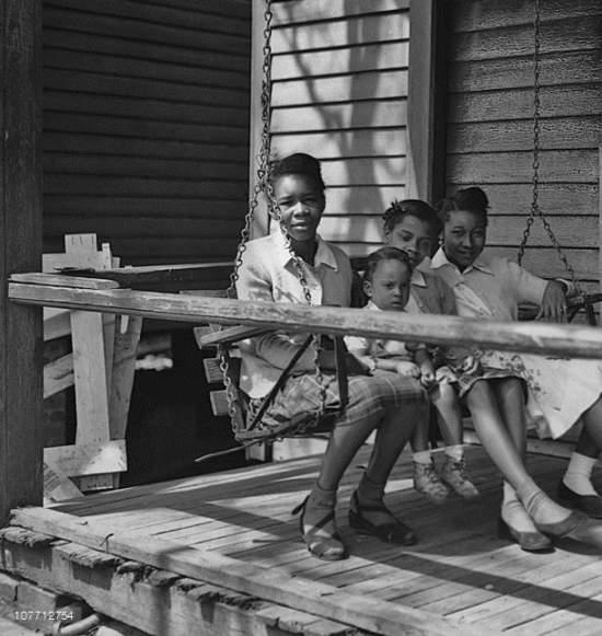
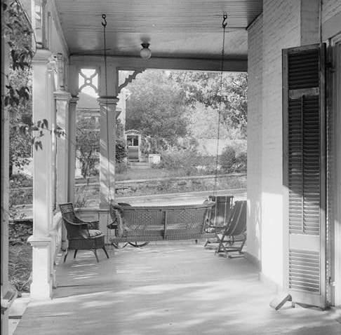


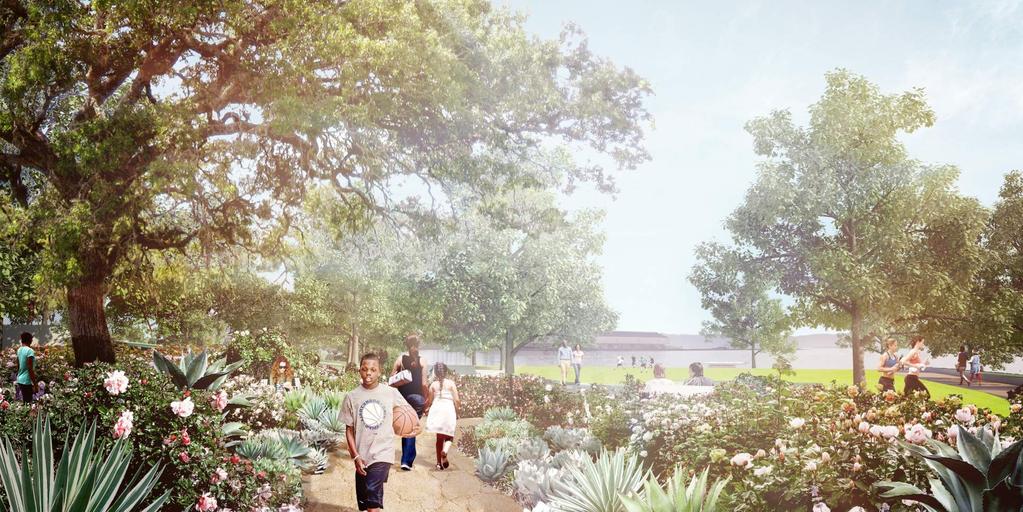
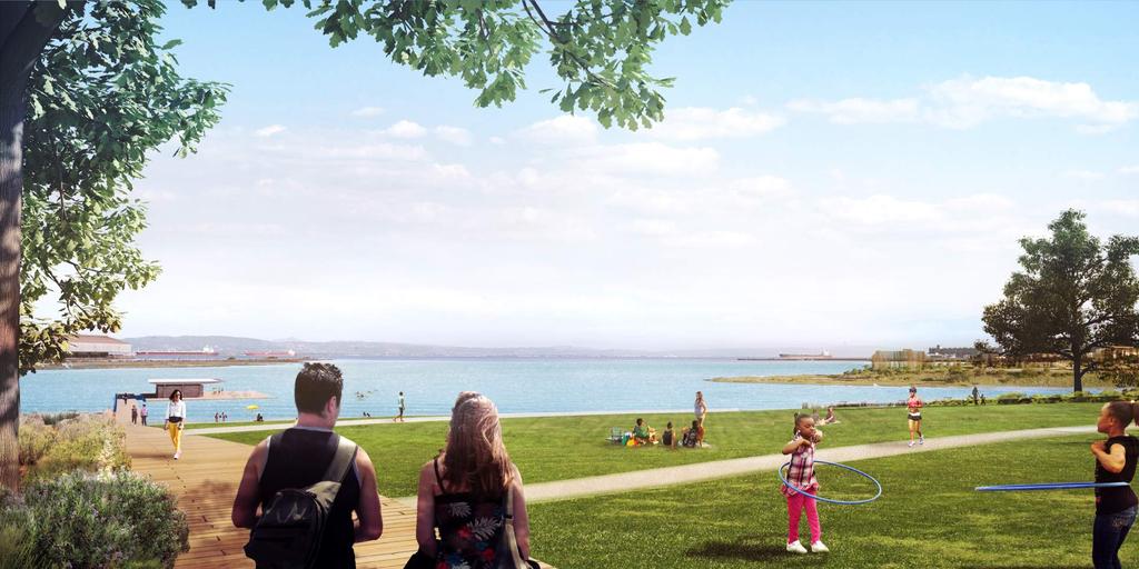
5 Gathering Space: Porch Swings, Social Seating


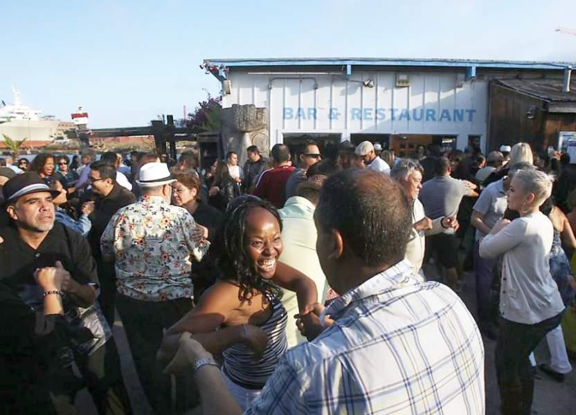
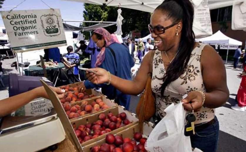
6 Gathering Space: Plazas, Food Trucks, Markets, BBQs, Picnicking, Groups
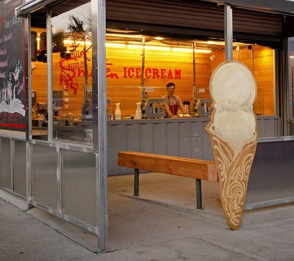

7 Concessions: Buy Snacks, Coffee, Ice Cream


8 Play & Fitness: Kids


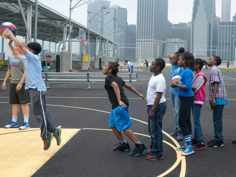
9 Play & Fitness: Teens


10 Play & Fitness: Adults

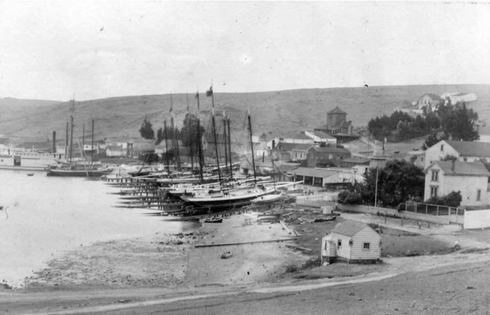
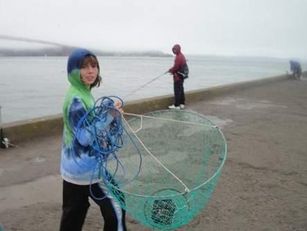
11 History: Shoreline


12 History: Historic Resources Evaluation Contributing Features Contributing Features: 2. Griffith Street right-of-way 3. Path between Griffith Street and west construction ways 5. Historic storage and staging area 6. Wood marineways at west construction ways 13. Office 14. Tool shed and water tank building 15. Shipwright s Cottage 21. Water fence posts Contributing Features Kept in Design: 2. Griffith Street right-of-way 3. Path between Griffith Street and west construction ways 5. Historic storage and staging area 6. Wood marineways at west construction ways 15. Shipwright s Cottage 21. Water fence posts Non-Contributing Features Kept in Design: 7. Marineways at east construction ways 9. Central construction way ramp and marineway foundation 12. Paint shop and compressor house 18. Modern dock


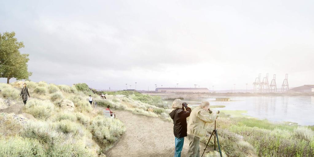
13 Naturalistic Areas - Riprap To Tidal Marsh Current Site Condition: Riprap Proposed Site Condition: Tidal Marsh


14 Naturalistic Areas - Habitat For Native Plants And Animals Saltwater harvest mouse Great egret Alameda song sparrow Willet Purple shoreline crab
15 Sea Level Rise - Current Mean High Water Today MHW: MHW: MHW:
16 Water Resources - Treating Runoff Within The Site Bioswales & Bioretention Gardens Constructed Wetlands Filter Stormwater
 NEIGHBORHOOD EDGE & HISTORIC SHOREWALK 1 2 3 4 5 6 7 8 Restored Shipwright s Cottage Welcome Center Innes Ave Porch")


17 Park Map HAWES ST HUNTERS POINT BLVD 6 21 PG&E (SHORELINE TRAIL) INNES AVE BUILD INC (INDIA BASIN OPEN SPACE & BIG GREEN) NEIGHBORHOOD EDGE & HISTORIC SHOREWALK Restored Shipwright s Cottage Welcome Center Innes Ave Porch Swings Overlook Porch Pavilion Garden Path + Accessible Ramp Griffith Street Steps Heritage Garden Parking Shorewalk Promenade SCOW SCHOONER BOATYARD 9 Historic Scow Schooner Boatyard Artifacts Floating Piers Shop Building Gravel Beach Play Area SAGE SLOPES Adventure Play Area 1/4 Mile Recreation Loop Adult Fitness Stations Skate Bypass Wave Paths Basketball Courts Parking and Bus Drop-Off Outfitter Pavilion Boatdeck and Seat Steps THE MARINEWAY BBQ and Picnic Bosque Play Lawn Sloped Lawn Gravel Beach Floating Dock Restroom Bay Trail / Blue Greenway Route Class 1 Bikeway Route

18 Site Plan SCALE: 1 =
19
20
21
22

23 900 Innes Buildings: Proposed

24 900 Innes Boatyard: Proposed
San Francisco Recreation and Park Commission Capital Committee. CEQA Findings and Concept Design for India Basin Shoreline Park/900 Innes
 Date: August 1, 2018 To: Through: From: Subject: San Francisco Recreation and Park Commission Capital Committee Philip A. Ginsburg, General Manager Nicole Avril, Project Director, Capital Partnerships
San Francisco Recreation and Park Commission Capital Committee
 Date March 7, 2018 To: Through: From: Subject: San Francisco Recreation and Park Commission Capital Committee Philip A. Ginsburg, General Manager Nicole Avril, Project Director, Capital Partnerships India
Philip A. Ginsburg, General Manager Dawn Kamalanathan, Director, Planning and Capital Projects
 Date August 5, 2015 To: Through: From: Subject: Recreation and Park Commission Capital Committee Philip A. Ginsburg, General Manager Dawn Kamalanathan, Director, Planning and Capital Projects Nicole Avril,
PHASE 3-4 PARKS SOUTH PARK AND CHANNEL PARK
 PHASE 3-4 PARKS SOUTH PARK AND CHANNEL PARK Sheet List L1.0 L2.0 L3.0 L4.0 L5.0 L6.0 L7.0 L8.0 L9.0 L10.0 L11.0 L12.0 L13.0 L14.0 L15.0 L16.0 L17.0 L18.0 L19.0 L20.0 L21.0 L22.0 Cover Open Space Context
WELCOME PG&E HUNTERS POINT COMMUNITY OPEN HOUSE THANK YOU FOR COMING PG&E
 WELCOME PG&E HUNTERS POINT COMMUNITY OPEN HOUSE THANK YOU FOR COMING NEWHALL ST JENNINGS ST B SHORELINE I SHORELINE EVANS AVE J C/D MIDDLE POINT ROAD OPERATING SUBSTATION A SHORELINE H Remediation Complete
MCCOYS CREEK RESTORATION 30% DESIGN
 MCCOYS CREEK RESTORATION 30% DESIGN THE MCCOYS CREEK RESTORATION PLAN The restoration plan aims to reduce flooding, restore ecosystem health, expand recreational opportunities along the creek, and connect
1. Parks & Recreation Neighborhood Parks Community Parks Special Use Sites 2. Open Space 3. Trails
 Appendix A: Park Classifications The intent of parks and recreation classifications is to aid in making acquisition and design decisions for park sites, facilities and the organization of recreation space
MEMORANDUM. March 10, 2017
 MEMORANDUM March 10, 2017 TO: FROM: MEMBERS, PORT COMMISSION Hon. Willie Adams, President Hon. Kimberly Brandon, Vice President Hon. Leslie Katz Hon. Eleni Kounalakis Hon. Doreen Woo Ho Elaine Forbes Interim
BAY AREA PARKS & RECREATION
 BAY AREA PARKS & RECREATION ALCATRAZ ISLAND CLIFF STABILIZATION Alcatraz Island San Francisco Bay California National Park Service Wiss Janney Elstner Associates Geologic Hazards Geotechnical Site/Civil
Subject: Sea Level Rise Constraints and Opportunities for India Basin
 Memorandum To: Monica Melkesian, Build Inc Cc: From: Leslie Lazarotti lazarotti@wra-cacom Ext 1300 Subject: Sea Level Rise Constraints and Opportunities for Date: July 8, 2015 The impetus for this study
PORT OF SAN FRANCISCO
 PORT OF SAN FRANCISCO WATERFRONT LAND USE PLAN Prop H (1990) required a Waterfront Land Use Plan Port property in BCDC jurisdiction Define Acceptable Uses Hotels prohibited on piers Prioritize Maritime
Point Defiance Park. Master Plan Update. April 23 rd 2015
 Point Defiance Park Master Plan Update April 23 rd 2015 Public Participation 1/29, 2/26, 3/26 & 4/23 Tonight s Agenda: Introduction: March Meeting Recap: Overview Feedback Responses Presentation of Master
VIRGINIA KEY CONSENSUS MASTER PLAN
 VIRGINIA KEY CONSENSUS MASTER PLAN JULY 2010 Existing Conditions JULY 2010 STAKEHOLDER INTERVIEW PROCESS, January 18-22, 2007 PUBLIC MEETING #1: SITE INVENTORY AND ANALYSIS, March 29, 2007 PUBLIC MEETING
AREA-WIDE PEDESTRIAN AND BICYCLE CIRCULATION
 OUSD LANEY CHILD CARE CENTER ART BUILDING LANEY COLLEGE BALL FIELDS PCCD OFFICES PERALTA PARK AQUATIC CENTER & ESTUARY PARK EDOFF MEMORIAL BANDSTAND SNOW PARK COURT HOUSE OAKLAND MUSEUM OAK ST AREA-WIDE
Provide and maintain sufficient public parks, recreation facilities, and open space to meet the recreational needs of County residents and visitors.
 (ROS) Goal Provide and maintain sufficient public parks, recreation facilities, and open space to meet the recreational needs of County residents and visitors. OBJECTIVE ROS.01 The County shall acquire,
Emerson Park Master Plan Update. Public Meeting III August 27, 2014
 Emerson Park Master Plan Update Public Meeting III August 27, 2014 Meeting Agenda: Project Update Presentation of Master Plan Components Discussion and Feedback The Path Forward: Building on the Concept
nokomis-hiawatha regional park master plan and park improvements
 master plan and park improvements CAC Workshop # August 26th, 2014 charge of the cac The Nokomis Hiawatha Regional Park CAC shall: Become knowledgeable about the project and its scope Understand and represent
Citizen s Advisory Committee
 Citizen s Advisory Committee 13 Members 6 Meetings (5 Locations) 1 Public Meeting Numerous Report Drafts Countless Hours of Review Immeasurable Input Special Thank You To: Jack Cohen Brian Kile George
Draft Master Plan for Franklin Park
 Draft Master Plan for Franklin Park Metro Parks Tacoma with SiteWorkshop November 2009 I. overview & background Process & History Master Plan Process The Master Plan is based on a community involvement
New York City, 19 th c.
 New York City, 19 th c. Lower Manhattan, circa 1930s Westside Highway, Manhattan, circa 1940s Greenpoint Terminal Market, Brooklyn TRANSFORMATIONS ON THE WATERFRONT Harlem River Park, Manhattan BEFORE
Port of Camas-Washougal Waterfront Trail Master Plan
 Port of Camas-Washougal Waterfront Trail Master Plan The Port s facilities are the products of its mission: To make strategic investments that enhance the community s quality of life by bringing jobs,
Waterfront Development Master Plan
 PORT of VANCOUVER USA Vancouver, WA Waterfront Development Master Plan DRAFT - FINAL CONCEPTUAL MASTER PLAN PROJECT TEAM NBBJ Heritage Research Associates JLA Kittelson Associates Leland Consulting Group
Focus Groups. 8 Focus Group meetings including 2 with staff, 1 with seniors, and 1 with students
 Project Team Nan Lanahan, Parks & Recreation Jason Gallo, Parks & Recreation Rob Leslie, DEDP John Smolinsky, Planning Board Brent Meredith, Highway Joan Gavrilik, Friends of Parks & Rec MaryLyn Koval,
Appendix E: Illustrative Green Infrastructure Examples
 Appendix E: Illustrative Green Infrastructure Examples Integrating LID into San Francisco s Urban Landscape Figure E. High-density Residential Figure E. Low-density Residential Figure E. Mixed Use 7 Figure
Dowdy Park. Concept Plans TOWN OF NAGS HEAD NORTH CAROLINA. Developed by: Albemarle & Associates, Ltd VHB/ Vanasse Hangen Brustlin, Inc.
 TOWN OF NAGS HEAD NORTH CAROLINA Concept Plans Developed by: Albemarle & Associates, Ltd VHB/ Vanasse Hangen Brustlin, Inc. Site Looking Southeast Dowdy Park Existing Conditions Nags Head Woods Sound Future
PARKS. Chapter Introduction
 Chapter 4. PARKS 4.1. Introduction This Parks Element of the 2016 Comprehensive Plan Update provides direction and guidance, based on citizen input, in order to improve and maintain the City s existing
JACKsON STREET PIER CONCEPTUAL DESIGN PACKAGE SEPTEMBER 21, 2017
 JACKsON STREET PIER CONCEPTUAL DESIGN PACKAGE SEPTEMBER 21, 2017 JACKsON STREET PIER Process outline DESIGN PROCESS OVERVIEW: Sandusky s Jackson Street Pier Conceptual Design process included input from
LAKEVIEW VILLAGE VISION & MASTERPLAN PRESENTATION TO CITY OF MISSISSAUGA. April 9, 2018
 LAKEVIEW VILLAGE VISION & MASTERPLAN PRESENTATION TO CITY OF MISSISSAUGA April 9, 2018 AGENDA Introduction Vision Plan Comparison The Big Moves Trail Connections Plan Overview Districts Conveyance Comparison
SOUTHEAST SPORTS COMPLEX MASTER PLAN
 REPORT TO SOUTHGATE NEIGHBORHOOD COUNCIL APRIL 13, 2016 Visioning Process April 30: Stakeholder Meeting with Sports Groups May 5: Stakeholder Meeting with Southgate Land Use Committee May 13: SNC Meeting
Port of San Diego Sea Level Rise Ad Hoc Committee Meeting 1 of 3.. September 18, 2018
 Port of San Diego Sea Level Rise Ad Hoc Committee Meeting 1 of 3. September 18, 2018 Agenda Welcome Introductions Rules of the Ad-Hoc Presentation Background Vulnerability Assessment Results Non-Agenda
4 Park Planning and Design
 4 Park Planning and Design Park Constellations Elliot Gateway/Mills Loring North Loop Commons Twins Minneapolis Park & Recreation Board Downtown Service Area Master Plan 4-1 PROJECT APPROACH REFERENCE
PARTF Scoring System for Grants
 PARTF Scoring System for Grants The members of the N.C. Parks and Recreation Authority use the PARTF scoring system as one of several tools to select grant recipients. Please provide all of the information
Welcome! HORSESHOE BAY PARK. Welcome!
 Welcome! HORSESHOE BAY PARK Welcome! Where are we in the process? Today we would like your input on how Horseshoe Bay Park can be upgraded to serve the community s needs better. CONSULT STAKEHOLDERS TAKE
NYC Parks by the Numbers
 Designing NYC Parks NYC Parks by the Numbers 30,000 acres of land 14% of New York City 5,000 individual properties 1,800 basketball courts 1,000 playgrounds 800 athletic fields 67 public pools 51 recreational
Providence Waterfront Park
 I-195 Redevelopment Parcels Providence Waterfront Park June 30, 2014 I-195 30% Design Review 1 November 19, 2012 endorses open space design. 2 Design Chronology October 2013 10% Design Submitted for both
SAN FRANCISCO RECREATION + PARKS DEPARTMENT MARGARET HAYWARD PLAYGROUND COMMUNITY WORKSHOP #1 WEDNESDAY, JANUARY 27, 2016
 SAN FRANCISCO RECREATION + PARKS DEPARTMENT MARGARET HAYWARD PLAYGROUND COMMUNITY WORKSHOP #1 WEDNESDAY, JANUARY 27, 2016 Supervisor London Breed District 5 Project Managers Marien Coss Cara Ruppert Recreation
A 2012 Clean and Safe Neighborhood Parks Bond Project. Katy Tang, District Supervisor. Jasmine Kaw, Landscape Architect Will Kwan, Architect
 West Sunset Park A 2012 Clean and Safe Neighborhood Parks Bond Project Community Meeting #2 November 20, 2013 Katy Tang, District Supervisor Dan Mauer, Project Manager Jasmine Kaw, Landscape Architect
Bristol Marsh Heritage Conservancy
 Bristol Marsh Heritage Conservancy The Pennsylvania Environmental Council (PEC) protects and restores the natural and built environments through innovation, collaboration, education and advocacy. PEC believes
San Diego River Coalition 2012 Work Plan
 San Diego River Coalition 2012 Work Plan Adopted November 18, 2011 The mission of the San Diego River Coalition is preserve and enhance the San Diego River, its watershed, and its natural, cultural and
Y Sports Complex PROGRAMMING Capitol Improvement Plan. Anticipated/Suggested Improvements. Sedgwick County Park: Sports Complex:
 PROJECT OVERVIEW Location: East of Ridge Road, between 21 st Street and 13 th Street, not including SCZ In conjunction with The Sedgwick County Park Facilities Observation Report Compilation of improvements
San Francisco Parks Alliance. #WeMakeParksHappen
 San Francisco Parks Alliance #WeMakeParksHappen SFPA - over the years Created Park Partner Program Rebuilt the Conservatory of Flowers Passed Proposition B Mobilized the Blue Greenway Invested over $100
Marshview Park. Concept Briefing and Feedback Session. Aquarium/Owls Creek Plan Steering Committee March 20, 2012
 Marshview Park Concept Briefing and Feedback Session Aquarium/Owls Creek Plan Steering Committee March 20, 2012 1 Outline of Today s Discussion Introductions Context for Marshview Park Site analysis -
M i s s i o n B a y W a t e r f r o n t
 114 M i s s i o n B a y W a t e r f r o n t Character of the Area: The Mission Bay Waterfront extends from Pier 48 at China Basin Channel to 18th Street in the Central Basin. This area of the waterfront
1.1 WATERFRONT SEATTLE
 1.1 WATERFRONT SEATTLE Over the past few years, the City of has been actively re-imagining the future of its Central Waterfront. The imminent replacement of the Elliott Bay Seawall and removal of the Alaskan
Baylands Segment J. Bay between the Golden Gate and Segment J. Coyote Point. of For managed ponds. included habitat enhancement.
 Baylands Segment J Crissy Field Alameda Naval Air Station Heron's Head Park COLMA CREEK SFO Millbrae San Mateo BAYLANDS 2009 SAN FRANCISCO AREA san francisco area Western side of central San Francisco
Notice of Preparation (NOP) of an Environmental Impact Report and Public Scoping Meeting for the Alameda Shipways Residential Project
 of an Environmental Impact Report and Public Scoping Meeting for the Alameda Shipways Residential Project") Notice of Preparation (NOP) of an Environmental Impact Report and Public Scoping Meeting for the Notice is hereby given that the City of Alameda, Lead Agency, will prepare an Environmental Impact Report
Notice of Preparation (NOP) of an Environmental Impact Report and Public Scoping Meeting for the Notice is hereby given that the City of Alameda, Lead Agency, will prepare an Environmental Impact Report
WILLIAM PAYNE SPORTS PARK MASTER PLAN BOARD OF DIRECTORS PRESENTATION
 WILLIAM PAYNE SPORTS PARK MASTER PLAN BOARD OF DIRECTORS PRESENTATION December 12, 2018 PROJECT OVERVIEW GOALS OF MASTER PLAN 1. Engage Community in Master Plan Process 2. Maximize Park Space for Sports
SOUTH PARK. Construction of a Portion of South Park at Fresh Kills Park, Staten Island
 SOUTH PARK Construction of a Portion of South Park at Fresh Kills Park, Staten Island FRESHKILLS PARK FIRST PHASE OF SOUTH PARK FRESHKILLS PARK CONTEXT SOUTH PARK EXISTING CONDITIONS PROJECT OPPORTUNITIES
Las Colonias Park Master Plan
 2013 Las Colonias Park Master Plan City of Grand Junction June 2013 Introduction Las Colonias Park, a 101 acre parcel on the edge of the Colorado River south of downtown, was deeded to the City of Grand
ITA and Vicinity Master Plan Update
 1 ITA and Vicinity Master Plan Update PHASE 3 SEPTEMBER 27, 2017 Three Phase Process 2 Phase 1 - Understanding October 13th Public Meeting Phase 2A - Exploring Ideas November 17th Public Meeting Phase
Community Meeting #2. Cabrillo Playground Renovation A 2008 Clean and Safe Neighborhood Parks Bond Project
 Cabrillo Playground Renovation A 2008 Clean and Safe Neighborhood Parks Bond Project Community Meeting #2 September 22, 2010 District Supervisor Eric Mar Paulina Araica, Project Manager Andy Maloney, Architect
India Basin/Hunters Point Shoreline Community Workshop May 21, 2008
 India Basin/Hunters Point Shoreline Community Workshop May 21, 2008 Workshop Agenda Welcome Process Overview Context & Existing Conditions Presentation of Draft Concepts Land Use and Open Space Priorities
The open space system should provide connective elements, relate to natural resources, and enhance the suburban character of the landscape..
 The open space system should provide connective elements, relate to natural resources, and enhance the suburban character of the landscape.. Mixed-use and infill development should maintain or enhance
Reconnecting to a Forgotten River St. Cloud MN. Aaron Hanson Design Design Thesis LA 572, Thesis, Spring 2012
 Reconnecting to a Forgotten River St. Cloud MN Aaron Hanson Design Design Thesis LA 572, Thesis, Spring 2012 site context 2.5 Miles Sartell St. Cloud to Fargo 170 Miles (2 hrs 45 mins) Hwy 10 infrastructure
Neighborhood Districts
 NEIGHBORHOOD DISTRICTS SEVEN MAIN DISTRICTS Neighborhood Districts While the Development Plan provides a broad-scale overview of the neighborhood, this section focuses on uses and relationships at the
ANCHORAGE PARK REPORT CARD Assessing A Park s Appearance, Function, & Condition
 ANCHORAGE PARK REPORT CARD Assessing A Park s Appearance, Function, & Condition Park Name: Is Your Park an A or an F? Your Name: Contact Information Optional: Date: General Instructions: Phone: Email:
NEFC PARK DESIGN STAGE 2: CONCEPT DESIGN REPORT JAMES CORNER FIELD OPERATIONS PWL PARTNERSHIP MODUS PUBLIC
 NEFC PARK DESIGN STAGE 2: CONCEPT DESIGN REPORT PWL PARTNERSHIP MODUS PUBLIC 2 PWL PARTNERSHIP MODUS PUBLIC TABLE OF CONTENT STAGE 2 CONCEPT DESIGN REPORT i. A Park for NEFC Stage 2 Engagement Key Guiding
10.0 Open Space and Public Realm
 10.0 Open Space and Public Realm 10.0 Open Space and Public Realm The Public Open Space System is comprised of: outdoor spaces available for public use that are either publicly owned (e.g., parks and
Queensborough Eastern Neighbourhood Node. Community Open House
 Queensborough Eastern Community Open House The Vision The Queensborough Eastern will become the heart of eastern Queensborough. Through a sensitive mix of viable commercial and residential areas, the neighbourhood
Highland Falls Waterfront Redevelopment Feasibility Study Village Board Meeting March 20, 2017
 Village Board Meeting March 20, 2017 Agenda I. Public Meeting #1 Visioning Summary II. Public Meeting #2 Comment Summary III. IV. IV. Case Study: Milton Train Station Schematic Design Concepts Schedule/Next
Zoning and Development Considerations in the Boothbay Harbor Maritime/Water Dependent District
 Zoning and Development Considerations in the Boothbay Harbor Maritime/Water Dependent District Bob Faunce Lincoln County Planner Lincoln County Regional Planning Commission Board of Selectmen and Planning
ALTERNATIVE STATION AREA -
 ALTERNATIVE STATION AREA - THE 10 TH STREET GARDEN STATION Two alternative land use scenarios and designs are illustrated here: Scheme A - Transit-Oriented Development High to Mid-Density Residential /Office
CENTRAL ESTUARY PLAN AVISION FOR OAKLAND S WATERFRONT
 Central Estuary Plan A VISION FOR OAKLAND S WATERFRONT Specific Plan and Environmental Assessment Presentation to the Parks and Recreation Advisory Commission December 9, 2009 This Afternoon s Presentation
PARKS & RECREATION SUBCOMMITTEE. Oct. 1, 2015
 PARKS & RECREATION SUBCOMMITTEE Oct. 1, 2015 1999 Bond - $22,000,000 Land Acquisition Allen Station Phase II Neighborhood Parks PREVIOUS BOND ELECTIONS 1999 & 2007 2002 Bond - $4,000,000 Allen Senior Recreation
HUDSON RIVER WATERFRONT. Hudson River Waterfront Walkway
 HUDSON RIVER WATERFRONT Hudson River Waterfront Walkway The Hudson River Waterfront Bayonne Bridge to the George Washington Bridge 40 miles of waterfront land Hudson River Waterfront Conservancy 1988 Stakeholder
BURTON STATION STRATEGIC GROWTH AREA PLAN UPDATE PUBLIC MEETING 3/26/18
 BURTON STATION STRATEGIC GROWTH AREA PLAN UPDATE PUBLIC MEETING 3/26/18 1 WHERE WE ARE? 2 PRIMARY OBJECTIVES OF THE PLAN UPDATE 1. Update the land use designation for Burton Station Village to reflect
RECREATION, OPEN SPACE AND GREENWAYS ELEMENT GOALS, OBJECTIVES, AND POLICIES
 RECREATION, OPEN SPACE AND GREENWAYS ELEMENT GOALS, OBJECTIVES, AND POLICIES GOAL R-1: DEVELOP A RECREATION, OPEN SPACE AND GREENWAYS SYSTEM AS AN INTEGRAL COMPONENT OF AN OVERALL, COUNTY-WIDE ECONOMIC
Nonprofit Sector. Current Activities and What We Bring to the Table
 Nonprofit Sector Current Activities and What We Bring to the Table Heather Trim Our Green/Duwamish Watershed-Wide Stormwater Strategy Workshop May 4, 2016 Photo: Heather Trim EDUCATION/SOCIAL MARKETING
Shared Principles and Emerging Plan Directions
 Shared Principles and Emerging Plan Directions Introduction Since the Fairfield Neighbourhood planning process launched in June 2016, we have heard from many residents, businesses, groups and other people
RECREATION AND OPEN SPACE VISION
 City of South Lake Tahoe General Plan Policy Document Recreation and Open Space Element INTRODUCTION This element provides the policy context for the City of South Lake Tahoe to achieve its vision for
Introduction to the Shoreline Master Program (SMP) Update. City of Bellingham Planning Department 2005
 Update. City of Bellingham Planning Department 2005") Introduction to the Shoreline Master Program (SMP) Update City of Bellingham Planning Department 2005 Purpose of tonight s meeting: Specify which water-bodies are subject to the SMP. Identify the State
Introduction to the Shoreline Master Program (SMP) Update City of Bellingham Planning Department 2005 Purpose of tonight s meeting: Specify which water-bodies are subject to the SMP. Identify the State
Throughout. square. (Crystal City Vision Plan 2050)
") 1: Terms related to the PSMP document 1 public space (see also public realm, civic space) An open space designated on the regulating plan, accessible to all, including Plazas, Mini Parks, and Neighborhoods
1: Terms related to the PSMP document 1 public space (see also public realm, civic space) An open space designated on the regulating plan, accessible to all, including Plazas, Mini Parks, and Neighborhoods
Little Neck Planning Area
 Little Neck Planning Area Current Reality The Little Neck Planning Area is characterized by established residential neighborhoods, Town Center and Pembroke. The Eastern and Western Branches of the Lynnhaven
New Park / Entry Court & Plaza Concept Design
 New Park / Entry Court & Plaza Concept Design The SECC Public realm is proposed to have a focus on health, wellness, and community and that site users will include patrons of the neighbourhood. The block
Project Location and Description
 ATTACHMENT 1 TO REVISED NOTICE OF PREPARATION MARCH 2005 The Village at Loch Lomond Marina (Revised) Project Location and Description I. INTRODUCTION A. Location and Surrounding Uses B. On-site Existing
COASTAL CONSERVANCY. Staff Recommendation December 13, 2007 COASTAL TRAIL AT LAND S END. File No Project Manager: Joan Cardellino
 COASTAL CONSERVANCY Staff Recommendation December 13, 2007 COASTAL TRAIL AT LAND S END File No. 07-086-01 Project Manager: Joan Cardellino RECOMMENDED ACTION: Authorization to disburse up to eight hundred
Keyport. Vision for Keyport
 Keyport Vision for Keyport Keyport is a rural, historic waterfront village bounded and limited in size by its natural borders of water and the Naval Undersea Warfare Center. The community consists primarily
New Brighton Park Shoreline Habitat Restoration Project
 Vancouver Board of Parks and Recreation and Port Metro Vancouver New Brighton Park Shoreline Habitat Restoration Project Conceptual Design Public Consultation August 26 September 9, 2015 Discussion Paper
SALEM FOREST RIVER PARK PRELIMINARY POOL AREA ASSESSMENT & MASTER PLAN STUDY. For the City of Salem
 SALEM PRELIMINARY POOL AREA ASSESSMENT & MASTER PLAN STUDY For the City of Salem 6-13-17 This process undertaken by Weston & Sampson is to outline preliminary ideas only of what possibilities exist for
Long Branch-Wayne Local Park Renovation Project
 Montgomery Parks Long Branch-Wayne Local Park Renovation Project Community Meeting #2 September 20, 2016 Oak View Elementary School 7:00-9:00 PM Welcome / Team Introductions M-NCPPC (Montgomery Parks)
Workshop #3 June 13, 2016
 Downtown Ocoee Master Plan Workshop #3 June 13, 2016 Our Team Our Team and Tonight s Goal Quick Recap: Why a Downtown Plan? How are we developing the plan? How can you still be involved? What s left to
Libby Zemaitis October 18, 2017 Climate Outreach Specialist, NYS DEC Hudson River Estuary Program
 1 Supporting Hudson Riverfront communities as Climate-Adaptive Leaders Libby Zemaitis October 18, 2017 Climate Outreach Specialist, NYS DEC Hudson River Estuary Program The Hudson River Estuary Program
Seven Creeks Neighbourhood. Community Plan
 Seven Creeks Neighbourhood Community Plan INTRODUCTION SEVEN CREEKS The Seven Creeks Estate is home to a steadily expanding community of families, couples and individuals who enjoy the very best of both
City of Naples Parks Master Plan (Draft)
") City of Naples (Draft) CSAB April 12, 2016 OVERVIEW Presentation Outline Overview Needs Assessment Recap Response to Needs Implementation Strategy Questions, Discussion Preserving Naples: A vision plan
City of Naples (Draft) CSAB April 12, 2016 OVERVIEW Presentation Outline Overview Needs Assessment Recap Response to Needs Implementation Strategy Questions, Discussion Preserving Naples: A vision plan
Courthouse Planning Area
 Courthouse Planning Area Current Reality The Courthouse Planning Area is the characterized by expansive suburbanscale residential areas as well as the community resource planned area of athletic, educational,
A larger version of this map is located on the last page of this PDF.
 MAP Committee Input McLoughlin Area Draft Vision Map A larger version of this map is located on the last page of this PDF. 1. The map above is intended to portray a vision for the McLoughlin area. It highlights
PRELIMINARY DESIGN + DEVELOPMENT PLAN
 WELCOME! To The Public Open House May 30 th, 2017 HARBOUR WEST PARKS Vision Project Overview The City s vision for Port Credit Harbour West Parks is to develop a vibrant waterfront destination that integrates
Description of Preferred Alternative
 Chapter 2 Description of Preferred Alternative 2.1 Introduction This chapter of the programmatic Sammamish Town Center Sub-area Plan Final EIS provides a more detailed description of the Preferred Alternative
Illustrative Development Plan
 Illustrative Development Plan December 7, 005 045 Sansome St., Studio 3 San Francisco, CA 94 Area A - Increase visibility to waterfront and aquatic center from the Embarcadero - Provide streets rather
SF REC & PARK STANYAN STREET IMPROVEMENT. Supervisor London Breed District 5. Project Manager Dan Mauer Recreation and Parks Department
 SF REC & PARK STANYAN STREET IMPROVEMENT PLANNING PRESENTATION WEDNESDAY, OCTOBER 19, 2016 Supervisor London Breed District 5 Project Manager Dan Mauer Recreation and Parks Department Design Team William
Manchester. Vision for Manchester
 Manchester Vision for Manchester The Manchester Community Plan is a statement of the community values and aspirations for the future. This is an effort to recognize what originally attracted visitors in
Lake Nokomis Shoreline Enhancement Project
 Lake Nokomis Shoreline Enhancement Project Community Meeting 2 February 13, 2018 Agenda Current Problems Project Goals Project Status Existing Conditions Community Input Draft Schematic Design Long-term
Tonight s Agenda. Disbrow Park & Facilities Master Plan
 Disbrow Park & Facilities Master Plan Public Outreach Forum City of Rye, NY May 11, 2017 Tonight s Agenda. Break (10 min) Introduction: What s in the works? Stantec Presentation - Goals and objectives
Meeting Three Saginaw Fairgrounds Urban Park Plan. New Beginnings Enrichment Center June 7, 2016
 Meeting Three Saginaw Fairgrounds Urban Park Plan New Beginnings Enrichment Center June 7, 2016 Acknowledgements Local Partners The following is a list of organizations who contributed input during the
M-NCPPC Park System in
 Park Planning & Stewardship Division Park & Trail Planning Section East County Science Center Master Plan Parks, Recreation, Trails, and Open Space- Issues and Opportunities PARK PLANNING & STEWARDSHIP
Pungo/Blackwater Planning Area
 Pungo/Blackwater Planning Area Current Reality The Pungo/Blackwater Planning Area represents the rural landscape and lifestyle that encompasses nearly 40% of Virginia Beach. The Agricultural Reserve Program
TOWN COUNCIL / PLANNING COMMISSION
 Workshop #3 TOWN COUNCIL / PLANNING COMMISSION January 20, 2011 Consultant Team In Attendance Tonight BMS Design Group Nevada City and San Francisco Michael Smiley, AICP, ASLA Partner-in-Charge Nancy L.
RPD GEORGE CHRISTOPHER PLAYGROUND COMMUNITY MEETING 1 SEPTEMBER 24, Duncan St
 RPD GEORGE CHRISTOPHER PLAYGROUND COMMUNITY MEETING 1 SEPTEMBER 24, 2015 Duncan St Supervisorial District 8 Supervisor Scott Wiener 1 Agenda Welcome & Introductions Purpose of Meeting Ground Rules Project
Public Workshop 2 December 11, 2014 OLIN
 Public Workshop 2 December 11, 2014 OLIN TRIPLE IMAGE PANORAMA A NEW VISION FOR THE RIVERFRONT PROMENADE Burlington s Riverfront has historically been a defining character of the City s identity. This
Lansing s Moores River Drive Regional Network Trail project extended the Lansing River Trail system to Waverly Road, and also included bike lane
 Lansing s Moores River Drive Regional Network Trail project extended the Lansing River Trail system to Waverly Road, and also included bike lane striping on W. Mount Hope Avenue. The boulevard on Moores