Contents. Summary Introduction Historical Background Building Description Discussion Sources
|
|
|
- Elfreda Lyons
- 6 years ago
- Views:
Transcription

1 Archaeological Building Survey: The Kitchen Garden, Worsley Hall Garden Centre, Worsley. Final Version. Client: Peel Investments (North) Ltd. Technical Report: V Nash, M Bishop, C Vallance & Dr M Nevell Report No: 9/2012 CfAA: Archaeological Building Survey: Kitchen Garden, Worsley (9) 1

2 Contents Summary 3 1. Introduction 4 2. Historical Background 6 3. Building Description 8 4. Discussion Sources Archive 19 Appendix 1: Figures 20 Appendix 2: Photograph Catalogue 46 CfAA: Archaeological Building Survey: Kitchen Garden, Worsley (9) 2
3 Summary The Centre for Applied Archaeology was commissioned by Peel Investments (North) Ltd to undertake a Level 2 Building Survey of the Kitchen Garden at Worsley Hall Garden Centre, Leigh Road, Worsley, M28 2LJ. The survey work was carried out in July 2011 by Vicky Nash and Dr Michael Nevell. The Kitchen Garden was constructed in the years 1840 to 1842 for the 1 st Earl of Ellesmere, Lord Francis Egerton. The Garden produced flowers, fruit, green crops and root crops which were required during the autumn and winter months, when the Ellesmere family were resident at Worsley New Hall. During the Great War the New Hall was used as a British Red Cross Hospital for injured soldiers and during this period the Garden supplied the hospital. In 1923 the Ellesmere family severed their connection to the New Hall and the Estate came into the control of the Bridgewater Estates Ltd, who leased the Garden to a series of tenants who operated a market garden business from the site. In 1949 it appears that the walled garden was sold to Richard and Herbert Cunliffe who operated New Hall Garden Produce Company and later the Worsley Hall Garden Centre from the site until the beginning of the 21 st century. In 2008 the site was purchased by Peel Investments (North) Ltd who have continued to lease the site as a Garden Centre. CfAA: Archaeological Building Survey: Kitchen Garden, Worsley (9) 3
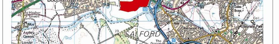
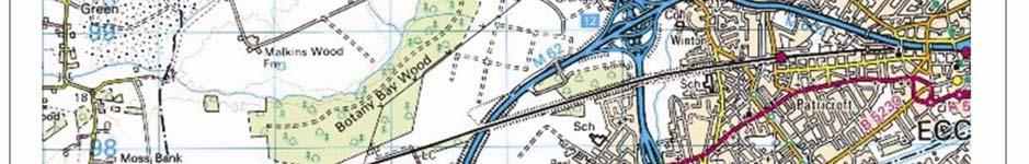
4 1. Introduction 1.1 Background The Centre for Applied Archaeology was commissioned by Peel Investments (North) Ltd to undertake a Level 2 Building Survey of the Kitchen Garden at Worsley Hall Garden Centre, Leigh Road, Worsley, M28 2LJ. The survey work was carried out in July 2011 by Vicky Nash and Dr Michael Nevell. 1.2 Location, Topography and Current Land Use The Kitchen Garden lies within the south-west corner of the Worsley New Hall Estate, approximately 4km west of Salford City centre, 0.5km east of Boothstown and 0.2km north of the Bridgewater Canal (Fig 1). The Kitchen Garden is centred at NGR SD and is bounded to the north, east and west by the Worsley Hall Garden Centre and to the south by a large area of grass land which abuts the northern bank of the Bridgewater Canal (Fig 1). The study area lies on a gentle slope which measures 22m AOD at its southern boundary and 30m AOD at its northern boundary. The Kitchen Garden was constructed in the years 1840 to 1842 for the 1 st Earl of Ellesmere, Lord Francis Egerton. The Garden produced flowers, fruit, green crops and root crops which were required during the autumn and winter months, when the Ellesmere family were resident at Worsley New Hall. During the Great War the New Hall was used as a British Red Cross Hospital for injured soldiers and during this period the Garden supplied the hospital. In 1923 the Ellesmere family severed their connection to the New Hall and the Estate came into the control of the Bridgewater Estates Ltd, who leased the Garden to a series of tenants who operated a market garden business from the site. In 1949 it appears that the walled garden was sold to Richard and Herbert Cunliffe who operated New Hall Garden Produce Company and later the Worsley Hall Garden Centre from the site until the beginning of the 21 st century. In 2008 the site was purchased by Peel Investments (North) Ltd who have continued to lease the site as a Garden Centre. There are no designations attached to the Kitchen Garden and it is not currently listed on the Greater Manchester Historic Environment Record. 1.3 Methodology This survey has followed the conventions laid down in Understanding Historic Buildings. A guide to good recording practice (English Heritage 2006) and the Institute of Field Archaeologists' Standard and Guidance for the archaeological investigation and recording of standing buildings or structures (IFA, Revised Edition 2001). CfAA: Archaeological Building Survey: Kitchen Garden, Worsley (9) 4
5 In brief this work comprised of: Historic research including a historic map regression exercise (scaled to a large, uniform size), examination of Census records, Trade Directories and local history sources from Salford Local History Library. A photographic survey showing general view of the building s exterior and setting; the overall appearance of the buildings principle rooms and circulation areas; detailed coverage of the buildings external and internal appearance; and architectural and structural features relevant to the building s design. The photographs have been taken as high resolution digital photographs, with the viewpoint directions shown on plans. A written report including a description of the structure; a discussion of the site s development and importance; and a photographic catalogue. CfAA: Archaeological Building Survey: Kitchen Garden, Worsley (9) 5
6 2. Historical Background 2.1 Introduction The background history of the Garden Cottage was mainly uncovered from cartographic evidence although a certain amount of information was obtained from local historical sources taken from Salford University Library, Salford Local History Library, the Bridgewater Estate Archive and Census Returns. 2.2 The Cartographic Evidence A description of the Worsley New Hall grounds in 1846 described the kitchen gardens as being built in the years (The Gardeners Chronicle, August 20, 1846, p. 867). An undated map from the Worsley Hall estate archives (now held by the Peel Group) show a proposed layout for the kitchen gardens. The OS survey of 1849 depicts a large square, walled kitchen garden to the immediate east of the Garden Cottage (Fig 2). The garden contained a perimeter path and two main central paths, which ran north-south and east-west, divided the garden into four compartment or quarters. Running the full length of the eastwest path was an internal partition wall with a central gateway and along the gardens perimeter wall were a total of eight entrance ways. The map also depicts several lean-to glasshouses positioned along the inner face of the gardens northern perimeter wall and a row of Potting Sheds/ Stores abutting the outer face of the wall (Fig 2). By the OS survey of 1896 a large lean-to glasshouse had been constructed along the southern face of the gardens central partition wall and the OS survey of 1909 shows that the glass house had a boiler pit, centrally located on the north side of the wall (Fig 3). During the same period a further glass house had been added along the eastern end of the gardens northern wall (Fig 3). The garden appears unaltered on all subsequent mapping up to the OS survey of 1975 which shows that the gardens central glass house had been demolished along with the central section of the gardens western wall(figs 4 & 5). The garden still survives on site today and forms part of the Worsley Hall Garden Centre and Wild Wings Bird of Prey Centre. 2.3 The Documentary Evidence Historical research confirms that after the death of the 3 rd Duke of Bridgewater in 1803 the Worsley Estate was passed to a Trust who managed the Estate until 1833, when the Dukes great nephew Lord Francis Leverson Gower took possession, (Thorp, 2009: 4). Shortly after inheriting the Estate Lord Gower made the Brick Hall his main residence and changed his name to Lord Francis Egerton later to be known as the 1 st Earl of Ellesmere, (Thorp, 2009: 4). During his occupation at Worsley the Earl was responsible for extensively developing the Estate and one of his first developments was the construction of the Kitchen Gardens around The garden was constructed on the south side of Leigh Road on the margins of Chat Moss and was approximately ten acres in size (Douglas, 1876: ). Historic plans held within the Bridgewater Estate Archives show that the Kitchen Gardens quarters were used to grow flowers, green crops and root crops (BEA/IV/C20/Vol: 838).The glass houses along the inner face of the northern wall comprised of a Vinery, two Peach CfAA: Archaeological Building Survey: Kitchen Garden, Worsley (9) 6
7 Houses and Melon and Cucumber pits, whilst the glass house along the gardens central partition wall was used as a Peach and Camellia House (Fig 7). Historical records suggest that the perimeter walls of the garden along with their associated glass houses were heated with flues using the Trentham wall case design with the heat being supplied by two boilers housed in the Potting Sheds, (Thorp, 2009: 5 & BEA/IV/C20/Vol: 837). The central Peach / Camellia House had its own flue and brick built stack which was heated by a Whites Boiler (BEA/IV/C20/Vol: 837). Historical research has established that the greatest portion of the fruit and vegetables produced in this garden were required during the autumn and winter, when the family were resident at Worsley (Baines, T. 1875, 71). After the death of the 3 rd Earl of Ellesmere in 1914 the gardens produce continued to supply the New Hall which was being used as British Red Cross Hospital for wounded soldiers (Thorp, 2009: 5). In 1923 the Ellesmere family severed their connection to the New Hall and the Estate came into the control of the Bridgewater Estates Ltd, who leased the garden and associates structures to Mr Arthur Upjohn (son of William Upjohn the gardener at the New Hall) for use as a market garden venture (Thorp, 2009: 5 & BEA/IV/C20/Vol: 825). In 1933 Arthur Upjohn passed away and the lease of the garden and associated structures was taken over by Wilfred Mather who resided at the Bothy. The walled garden continued to be used as a commercial market garden and nursery throughout the first half of the 20 th century and had several tenants; J Edwards, landscape gardener ( ), Messrs Foden & Benson ( ), Alcock & Hardman (1942 to 1947) and J Barber, market gardener ( ). In 1949 it appears that the walled garden was sold to Richard and Herbert Cunliffe who operated New Hall Garden Produce Company and later the Worsley Hall Garden Centre from the site until the beginning of the 21 st century. In 2008 the site was purchased by Peel Investments (North) Ltd who have continued to lease the site as a Garden Centre. CfAA: Archaeological Building Survey: Kitchen Garden, Worsley (9) 7
8 3. Building Description 3.1 Introduction This section provides a description of the garden as visible at the time of the survey. This is not an architectural description, but rather an archaeological assessment of the gardens fabric, space and function as recovered from a photographic survey (Figs 8 to 43). The findings of this work will be used to inform an assessment of the gardens date, phasing and importance and will be a key document for informing decisions on preservation, alteration or demolition. 3.2 Exterior Description The Kitchen Garden at Worsley occupied the south-western corner of the Worsley Estate, to the immediate east of the Garden Cottage, just north of the Bridgewater Canal. The garden was rectangular in plan and measured approximately 110.0m by 130.0m. The garden was enclosed by four walls, constructed from handmade red bricks laid in Flemish bond with sandstone coping. There were a total of eight entrance ways into the garden and along the northern elevation were a row of mid 19 th century, brick built Potting Sheds and a Boiler House. Northern Elevation (Figs 9-16) The northern wall of the garden was aligned roughly north-west/south-east and stood to a height of approximately 3.80m. At its western end the elevation was abutted by a small, half storey lean to structure with a corrugated asbestos roof. To the east of the lean to there was a single storey, Boiler House, constructed in handmade bricks, laid in Flemish bond with a single pitch, slate roof. The Boiler House contained a single light timber framed window along its western elevation, and along its northern elevation were four square headed windows with yellow sandstone splayed jambs, lintel and sill, which had been blocked by chipboard panels. Above the roof of the Boiler House, recessed into the coping of the northern elevation of the Kitchen Garden there was a single flue chimney with a common tapered tile pot. To the immediate east of the Boiler House was a block of four, single storey Potting Sheds which were separated from the Boiler House by a covered passageway. At its northern end the passageway contained a set of double wrought iron gates and at its southern end was a square headed doorway with a yellow sandstone lintel and splayed stone jamb with carved stop chamfer, which led into the north-west quarter of the Kitchen Garden. The eastern and western walls of the passage way comprised of the western elevation of Potting Shed and the eastern elevation of Boiler House. Both elevations contained a single square headed doorway, with a yellow sandstone lintel and splayed stone jamb with carved stop chamfer. As with the Boiler House the Potting Sheds were constructed from handmade red bricks, laid in Flemish bond and contained a single pitched, slate roof with coping at the gables. As previously described the western elevation of the Potting Sheds was concealed by the covered CfAA: Archaeological Building Survey: Kitchen Garden, Worsley (9) 8
9 passage way which provided access through the northern elevation into the Kitchen Garden. The northern elevation of the Potting Sheds contained a total of eleven, square headed windows with yellow sandstone splayed jambs, lintels and sills, which had been blocked with chipboard panels. At the centre of the elevation was a large square headed doorway with a yellow sandstone splayed jamb, within which was a wooden plank and batten door which contained six lights. At the base of the doorway were two sandstone steps, approximately 0.40m in height. The lintel of the doorway appeared to have been removed and above the doorway the central section of the roof had been damaged and replaced by corrugated sheeting. Flanking the central doorway, were a further two square headed doorways, of the same design, which had sandstone thresholds and timber plank and batten doors and at the eastern end of the elevation there was a fourth, double width doorway of identical design which contained a plank and batten, sliding door which was carried on a metal bracket. The eastern end of the elevation contained a second, later inserted, square headed doorway which had a timber lintel and a timber panelled doorway which had been blocked with chipboard panels. To the immediate east of the Potting sheds the northern elevation contained a large double width opening containing a set of cast iron gates, which provided access into the north-east quarter of the Kitchen Garden. To the east of this entrance the eastern end of the elevation was abutted by a single pitch, metal framed, lean to structure. The structure was open and contained five stalls which were covered by a corrugated asbestos sheet roof. To the east of the lean to structure the northern elevation contained a later inserted, square headed doorway with a yellow sandstone lintel and splayed stone jamb with carved stop chamfer, and a stone step approximately 0.40m above ground level which led into the north-east quarter of the Kitchen Garden. Eastern Elevation (Figs 17-22) The eastern wall of the garden was aligned roughly north-east/south-west and stood to a height of approximately 3.80m. The wall was constructed from handmade red bricks laid in Flemish bond and was capped by yellow sandstone coping. Along the northern half of the wall there were two square headed doorways, both with yellow sandstone lintels and splayed jambs with carved stop chamfer, which led into the north-east and south-east quarters of the garden. The most northerly of the doorways contained an elaborate metal turnstile gate. To the immediate south of the doorways, along the southern half of the wall was a later inserted brick built pilaster constructed from machine made bricks laid in Stretcher bond and capped with concrete bricks. To the immediate south of the pilaster the level of the wall dropped to 1.50m above ground level forming a steep sided concave curve within the wall and several metres south of this the level of the wall dropped once again to 1.30m in height, before abutting the brick pilaster as the eastern end of the gardens southern elevation. Southern Elevation (Figs 23-25) The southern wall of the garden was aligned roughly north-west/south-east and stood to a height of approximately 1.30m. The wall was constructed from handmade red bricks laid in Flemish bond and along its inner face were several brick built piers. The entire wall was capped with yellow sandstone coping stones, which contained the remains of iron fittings, suggesting that the wall would have originally been mounted with railings. At the eastern end of the wall was a sandstone pilaster, which stood to a height of approximately 1.70m and CfAA: Archaeological Building Survey: Kitchen Garden, Worsley (9) 9
10 abutted the southern end of the eastern elevation. At the centre of the wall was a large entrance way into the Kitchen Gardens southern quarters, which contained a set of modern wooden gates. At its western end the wall abutted a second sandstone pilaster, approximately 4.0m in height which formed the southern end of the western elevation. Western Elevation (Figs 26-28) The western wall of the garden was aligned roughly north-east/south-west and stood to a height of approximately 3.80m. The wall was constructed from handmade red bricks, laid in Flemish bond with yellow sandstone coping. At the northern end of the wall there was a square headed doorway, with a yellow sandstone lintel and splayed stone jamb with carved stop chamfer, which led into the north-west quarter of the garden. To the immediate south of the door, the wall was concealed by the Worsley New Halls Garden Centre shop and as such it was not possible to survey this section. Along the centre of the elevation, within the rear garden of the Garden Cottage was a second square headed doorway with a yellow sandstone lintel and splayed stone jamb, which led into the north-west quarter of the garden. To the immediate south of this doorway the elevation had been partially demolished leaving a large opening which provided access to the south-west quarter of the garden. To the south of the Garden Cottage the wall continued although it appeared to be constructed in machine made bricks and contained two brick pilasters capped with sandstone coping, and at its southern end the wall contained a third, sandstone pilaster which abutted the western end of the southern elevation. 3.3 Interior Description For ease of description the Kitchen Garden has been divided into two northern and southern sections which reflect the land use at the time of survey. Each section has been named according to its orientation within the garden and this division is depicted in (Figs 7 & 8). With reference to the Potting Sheds along the outer face of the gardens northern elevation, only the most westerly of the sheds was accessible at the time of survey and as such descriptions could not be made all four sheds. Kitchen Garden (Figs 29 42) The Kitchen Garden was rectangular in plan and was enclosed on all four sides by the northern, eastern, southern and western elevations. At its centre the garden was divided by a partition wall, which was aligned roughly north-west/south-east and ran between the western and eastern elevations of the garden. The wall was constructed from hand made red bricks laid in Flemish bond and was capped with yellow sandstone coping. At its western end the wall stood to a height of approximately 3.80m and contained a single square headed doorway with yellow sandstone lintel and splayed jamb with carved stop chamfer. To the east of the doorway the southern face of the wall contained the remains of four, cast iron fittings, which relating to the workings of the Glass House which formerly abutted the wall. At its centre the wall was a double width opening which was flanked by two, cast iron gate posts between which were a set of cast iron gates. To the east of the gateway the height of the central wall dropped to a height of approximately 2.50m and at the eastern end of the wall was a second square headed doorway with yellow sandstone lintel and splayed jamb with carved stop chamfer. CfAA: Archaeological Building Survey: Kitchen Garden, Worsley (9) 10
11 The northern half of the garden was occupied by the Worsley Hall Garden Centre and was bounded by the inner faces of the northern, eastern and western elevations and the north face of the central partition wall. As previously described within the Exterior Descriptions the northern half of the garden could be accessed via two doorways and a gated entrance way along its northern elevation and a further two doorways within its eastern and western elevations (Section 3.2). Along the western elevation of the garden was a large timber framed glass house which housed the Garden Centre Shop and flanking the gateway along the northern elevation were a further two large lean to, timber framed Glass Houses, which were in a state of disrepair. Within its interior the garden was divided by two gravel footpaths; aligned east/west and north/south and a third stone flagged footpath aligned east/west ran across the centre of the garden. In total the garden contained thirty two boxed flower beds of varying sized and twenty seven raised liner beds. With the exception of the tree linear raised beds, all beds were aligned north/south and were separated by narrow gravel covered pathways. In contrast the southern half of the garden was comprised of open grass land with several tall conifer trees around its borders. The garden was bounded by the inner faces of the southern, eastern and western elevations and the south face of the central partition wall. As previously described within the Exterior Descriptions the southern half of the garden could be accessed via one doorway along its eastern elevation and two double width openings located along the southern and western elevations (Section 3.2). The southern garden was divided into two by a rough gravel path, aligned roughly north/south, which ran between the gated openings on the southern and central elevations. To the east of the gravel footpath was the gardens south-east quarter which comprised of over grown, grassland and a row of tall conifer trees, aligned roughly north/south which ran alongside the eastern edge of the gravel footpath. Running alongside the western edge of the gravel footpath was modern metal wire fence with timber post supports which marked the eastern boundary of the gardens south-west quarter. The south-west quarter comprised of mown grass land, with a wooden shed in its north-west corner and several wooden benches and stands at its centre, which were used by the Wild Wings Bird of Prey Centre as a show arena. Boiler House (Figs 39 & 40) Located at the western end of the Kitchen Gardens north elevation, the Boiler House was rectangular in plan and could be accessed via a doorway in its eastern elevation. Inside, the Boiler House comprised of a storage room and a small office both of which had painted brick walls, stone flag floors and lath and plastered ceilings which dropped at an oblique angle at the northern end of the building. The storage room was located at the eastern end of the Boiler House and could be accessed via the aforementioned exterior door. The northern wall of the store room contained three, three light, timber framed windows which were blocked by chipboard panels as described on the northern elevation and along the southern wall of the room was a brick chimney breast with a cast iron fire surround (Section 3.2). At the western end of the store room were three stone steps approximately 0.50m in height, which led up into the smaller office room at the western end of the Boiler House. The only feature of archaeological interest within the office was a three light, timber framed window, blocked by a chipboard panel. CfAA: Archaeological Building Survey: Kitchen Garden, Worsley (9) 11
12 Potting Shed (Figs 41 & 42) Located to the immediate east of the Boiler House, the Potting Shed was rectangular in plan and could be accessed via a doorway in its western elevation. Inside, the Potting Shed comprised of two storage rooms which had stone flag floors and lath and plastered ceilings which dropped at an oblique angle at the northern end of the building. All walls within the potting shed were comprised of painted brick work with the exception of the upper section of the walls which were plastered. The larger store room located at the western end of the Potting Shed could be accessed via the aforementioned exterior door. Both the northern and southern walls of the store room were partially concealed by large metal storage shelves however one, three light, timber framed window was visible along the northern wall, which was blocked by chipboard panels as described on the northern elevation. The eastern wall of the larger store room contained a square headed timber doorway with a plank and batten door which led into a smaller store room. The only feature of archaeological interest within the smaller sore room was a three light, timber framed window, blocked by a chipboard panel. CfAA: Archaeological Building Survey: Kitchen Garden, Worsley (9) 12
13 4. Discussion 4.1 Introduction This section deals with the archaeological implications, (if any), of the survey data providing the context within which planning conditions affecting the archaeological resource can be assessed. 4.2 Phasing & Function Mid 19 th Century The earliest visible fabric within the Kitchen Garden at Worsley, were the remains of gardens exterior walls, the central internal wall and the Potting Sheds (Figs 2, 7 & 8). Documentary research has established that the Kitchen Garden was constructed in 1840 for the 1 st Earl of Ellesmere (Lord Francis Egerton), (Thorp, 2009: 4). Cartographic sources first depict the garden on the OS survey of 1848, which also confirms that all entrance ways through the aforementioned walls were part of the gardens original construction, with the exception of the double entrance to the rear of the Garden Cottage, which was formerly two single entrance ways and the doorway at the eastern end of the northern wall which was a later insertion (Figs 2 & 16). The onsite survey works also confirmed that all walls of Kitchen Gardens and the Potting Sheds were constructed from the same handmade, red bricks, laid in Flemish bond. In addition all of the doorways along the walls and through the Potting Sheds were identical in form and fabric, suggesting that all of the aforementioned structures were contemporary. Cartographic sources from this period also depict a large lean to glass house, flanked by two smaller glass houses along the inner face of the gardens northern elevation (Fig 2). Both the central and western glass houses appear on all subsequent OS mapping and still stand on site today, although both were in a dilapidated. Documents held within the Bridgewater Estate archive confirm that the larger glass house was a Vinery whilst the smaller glasshouse was used as a Peach House (BEA/IV/C20/Vol: 833). These documents also confirm that between 1914 and 1948 these glass houses were subject to extensive repairs and as such it is not possible to ascertain how much of the surviving structures belong to the mid 19 th century. Late 19 th Century Cartographic sources show that between 1850 and 1893 the Potting Sheds along the outer face of the gardens north elevation were extended westwards, (Fig 3). This phase of redevelopment involved the construction of a fifth shed structure to the immediate west of the Potting Sheds and the addition of a roof over the entrance way at the western end of the Northern Elevation, which was situated between the aforementioned structures. Documentary sources confirm that the new structure was a Boiler House, which housed two boilers used to heat the glass houses along the inner face of the north elevation (BEA/IV/C20/Vol: 837). The onsite survey works confirmed the structures function as a Boiler House through the presence CfAA: Archaeological Building Survey: Kitchen Garden, Worsley (9) 13
14 of a chimney breast within its interior which formed part of a single flue chimney visible in the coping of the northern elevation. In addition the onsite survey works revealed that the Boiler House was constructed to compliment the earlier Potting Sheds, through the use of hand made bricks laid in Flemish Bond and windows and entrance way with yellow sandstone lintels and splayed jambs. The expense involved in complimenting the gardens earlier structures would suggest that the Boiler was constructed during the New Halls prosperous years, most likely during the same period Bothy, which was constructed between 1871 and 1881 by Francis Charles Granville Egerton, the Third Earl of Ellesmere, (Fig 2 & Appendix 3). Cartographic sources also confirm that during this period a large lean to glass house was constructed along the southern face of the gardens central wall, (Fig 3). The glasshouse no longer stands on site today and cartographic sources suggest a mid 20 th century date for its demolition, (Figs 5 & 6). Documentary research confirms that the glass house was used for the growth of Peaches and Camellias and was heated by Whites boiler which was housed in a pit on the northern face of the wall (BEA/IV/C20/Vol: 837), (Fig 7). Although no longer standing the original ventilating apparatus, belonging to this period is still visible along the southern face of the central wall (Fig 37). Cartographic and documentary sources during this period also show that the small lean to glass house at the eastern end of the gardens northern elevation was extended eastwards and used as a Peach House (BEA/IV/C20/Vol: 837). This glass house appears on all subsequent OS mapping and still stands on site today, however documents held within the Bridgewater Archive suggest that it had been subject to extensive repairs and as such it is not possible to ascertain how much of the surviving structure belongs to the late 19 th century. Mid 20 th Century Documentary and cartographic sources suggest that during the first half of the 20 th century the Kitchen Garden remained structurally unaltered, with only minor repairs being done to the gardens existing structures. However between 1956 and 1975, cartographic sources show that the central section of the western elevation, to the rear of the Garden Cottage was demolished. This section of the wall had formerly contained two single entrances into the garden however the demolition had destroyed the southern entrance and in its place was a large opening running the entire width of the Garden Cottages rear garden, (Figs 5, 6 & 27). On site survey works also showed that at the eastern end of the gardens northern elevation a doorway had been added. The doorway is not depicted on any cartographic sources and although its sandstone surround appears to belong to the earliest phase of construction at the garden, the modern brick work surrounding the doorway, suggest t it was a later addition (Fig 16). Given the presence of original stone work within the doorway it could be suggested that the stonework came from the demolished entrance along the gardens western elevation suggesting that both the doorway and demolished wall were alterations made as part of the development of the Worsley Hall Garden Centre. The on site survey works also identified that the southern half of the gardens eastern elevation may once have once stood to full height but had been lowered at some point during the 20 th century. This was evident by the sudden drop in height along the wall, the use of concrete to cap the walls central brick pilaster and the change in brick work along the southern half of the elevation (Fig 21). Although no documentary evidence could be uncovered to confirm or date this alteration, it is worth noting that that documentary sources CfAA: Archaeological Building Survey: Kitchen Garden, Worsley (9) 14
15 from the late 19 th century make mention of the fact that the Kitchen Garden at Worsley New Hall had been built on the margins of Chat Moss. It is reported that these insecure foundations had caused the gardens walls to lean outwards and not even the mass of solid concrete underneath the walls had successfully kept them upright (Douglas:1875:214). In light of this information it could be suggested that the lowering of the southern half of the eastern elevation was done to combat the effects of insecure foundations. Late 20 th Century Cartographic sources show that during the late 20 th century the Worsley Hall Garden Centre expanded through the construction of the shop structure which abutted the outer face of the gardens northern elevation (Fig 6). In addition to the shop, the onsite survey works established that a glass house had been constructed along the inner face of the gardens western elevation along with a stone flag path which ran eastwards from the glass house to the gardens eastern elevation. In addition it would appear that it was during this period that the gardens interior was substantially altered, with the southern quarters of the garden being neglected whilst the northern quarters of the garden was redeveloped through the addition of concrete boxed, flower beds used by the Worsley Hall Garden Centre. 4.3 The Archaeological Context of the Worsley New Hall Kitchen Garde Walled kitchen gardens were at the top of their productivity between 1800 and 1939, owing to advances in technology and increased wealth. The ability to grow a vast range of plants, flowers, vines and fruits under the artificial climates of glass houses was a necessary addition to the grand Victorian lifestyle of endless entertaining, decoration and exotic foods (Whittle, 1992:69). In England, early kitchen gardens were situated in close proximity to the house they served. However with the advent of the landscaped park and gardens, the position of a high walled kitchen garden was considered to be detrimental to the view and aesthetic of the house and so moved farther away (Campbell, 2010: 8). In addition the kitchen garden would have had an industrial feel, owing to the noise, smoke and constant movement and this may also explain why the kitchen garden at Worsley was constructed away from the house. The kitchen garden at Worsley was constructed around 1840 and was approximately ten acres in size. The garden would have produced enough produce for one hundred and twenty people and would have required around twenty gardeners to maintain. When the kitchen garden was constructed the traditional four-square layout was followed. This was a cross-shaped arrangement creating four distinct sections, dissected by central paths running north-south and east-west. This design can be traced back to the ancient gardens of Greece and Rome, for practical reasons, but also emulation, as so much else in Victorian England (Campbell, 2010: 13). Walled gardens were primarily used for culinary purposes but it was common for owners to take walks around the gardens given that the main paths were gravel and wide enough for several people to walk abreast (Campbell, 2010: 12). The family were present at the house during the autumn and winter months and so required produce from the kitchen garden in the coldest months. Exotic fruits like pineapples, and tropical plants, required a certain amount of heat to be grown and the innovative heating system provided this. The majority of glasshouses at Worsley were constructed after the repeal of the Glass Tax in Glasshouses are one of the least durable of garden structures and very few survive. This is true at Worsley. Some of the framing remained for the glasshouses but they had been heavily repaired. CfAA: Archaeological Building Survey: Kitchen Garden, Worsley (9) 15
16 One of the greatest assets of a kitchen garden was its perimeter walls, which were used to protect the produce from thieves, create a warmer micro- climate and provide support for lean to buildings and plants (Campbell, 2010: 21). The perimeter walls of the Worsley kitchen garden, and the glasshouses were heated by flues using the Trentham method. This supplied heat via two boilers and moved through the flue system to heat the brick walls. Brick was used as it was strong, dry and heat retaining. The walls and glasshouses were heated to enable the gardeners to grow fruit and vegetables all year round. The warmth and support of the walls was used to maximum effect with the sunniest sides being devoted to glasshouses. The glasshouses were constructed on the inner, south facing side of the northern wall. In English Thompsons Gardener s Assistant of 1925 showed a typical kitchen garden layout of the time. This common design included wide borders bounded by a perimeter path within the walls and two main central paths, one running north-south and one east-west, dividing the ground into four quarters (Campbell: 2010: 9). Also illustrated were a collection of outbuildings and work sheds north of the north wall, with the longest wall facing south furnished with glasshouses. This design was exactly the same as the kitchen garden at Worsley. It exhibits that Worsley shared characteristics with typical kitchen garden designs of the time and was carefully laid out for maximum efficiency. Sugnall Hall in Staffordshire shared this typical style with Worsley (Campbell, 2010: 25). The kitchen garden was screened from the house by large trees and had a walled, four quarter style. The longest wall also contained the glasshouses, facing south. These glasshouses were added towards the end of the nineteenth century, as the majority were at Worsley. The same style and layout can also be seen at Calke Abbey in Derbyshire (Cambell, 2010: 15). As at Worsley, the kitchen garden is located away from the main house. The garden is divided by two main central paths but then subdivided further as this plot is larger than Worsley. The south facing, northern wall contained the glasshouses at Calke Abbey too, with the work sheds and outbuildings north of this wall. Worsley was a typical walled kitchen garden of the time. It adopted new technology, employed efficient uses of natural advantages and embraced innovations. CfAA: Archaeological Building Survey: Kitchen Garden, Worsley (9) 16
17 5. Sources Bibliography Appleby, T. 1859, The New Flower Garden at Worsley Hall (Page 400) in The Cottage Gardener and Country Gentleman, published 29 th March, Baines, T. 1875, Worsley Hall: Seat of the Earl of Ellesmere (Pages 70 & 71) in The Gardeners Chronicle, published 17 th July, Brownbill, J. & Farrer, W. 1911, A History of the County of Lancaster: Volume 4. Victoria County Histories. Brunskill, R.W. 2000, Vernacular Architecture: An Illustrated Handbook. Faber and Faber. Campbell, S. 2010, Walled Kitchen Gardens. Shire Publications Ltd. Currie, C. 2005, Garden Archaeology: A Handbook. Council for British Archaeology. Curtis, C.H. 1895, Worsley Hall: The Seat of the Earl of Ellesmere (Pages ) in The Gardeners Magazine, published 24 th August, Douglas, J. 1876, Worsley Hall (Pages ) in The Journal of Horticulture & Cottage Gardener, published 7 th September, Institute for Archaeologists. 1994, revised Standard and Guidance for Archaeological Desk-Based Assessment. Irvine, J. 1995, Worsley Park, Salford: An Archaeological Evaluation. University of Manchester Archaeological Unit. Oldham, C. 1914, Famous Gardens: Worsley Hall (Pages ) in The Journal of Horticulture, published 30 th April, Walker, J.S.F & Tindall, M. 1985, Country Houses of Greater Manchester. Greater Manchester Archaeological Unit. Whittle, E. 1992, The Historic Gardens of Wales. CADW Welsh Historic Monuments. Special Collections Bridgewater Estate Archives, 1840 to University of Salford Library. Maps CfAA: Archaeological Building Survey: Kitchen Garden, Worsley (9) 17
18 John Foulkes Plan of the Worsley Estate, OS 1 to 6 Mile, Edition 1849, Lancashire Sheet 103. OS 1 to 6 Mile, Coloured Edition 1896, Lancashire Sheet 103. OS 1:2500 Edition 1908, Lancashire Sheet OS 1 to 6 Mile, Quarter Sheet1 1909, Lancashire Sheet 103 NW. OS 1:2500, Country Series Edition 1928, Lancashire Sheet OS 1 to 6 Mile, Quarter Sheet1 1929, Lancashire Sheet 103 NW. OS 1 to 6 Mile, Country Series Provisional Edition 1949, Lancashire Sheet 103 NW. OS 1:10,560, National Grid Series 1956, Sheet SD 70 SW. OS 1:10,000, National Grid Series 1975, Sheet SD 70 SW. OS 1:10,000, National Grid Series 1991, Sheet SD 70 SW. OS 1:10,000, National Grid Series 1999, Sheet SD 70 SW. Trade Directories Kelly, 1920, Manchester, Salford & Suburban Directory Kelly, 1930, Manchester, Salford & Suburban Directory Kelly, 1939, Manchester, Salford & Suburban Directory Kelly, 1948, Manchester, Salford & Suburban Directory Kelly, 1959, Manchester, Salford & Suburban Directory Kelly, 1965, Manchester, Salford & Suburban Directory 6. Archive CfAA: Archaeological Building Survey: Kitchen Garden, Worsley (9) 18
19 The archive is currently held by the Centre for Applied Archaeology and a copy of this report will be forwarded to the client and deposited with the Greater Manchester Historic Environment Record (HER) held by the Greater Manchester Archaeological Unit. The archive consists of annotated field drawings, digital photographs, historic and modern mapping, census and trade directory entries along with photocopies of supporting historical documentary material. CfAA: Archaeological Building Survey: Kitchen Garden, Worsley (9) 19


20 Appendix 1: Figures CfAA: Archaeological Building Survey: Kitchen Garden, Worsley (9) 20
21 CfAA: Archaeological Building Survey: Kitchen Garden, Worsley (9) 21
22 CfAA: Archaeological Building Survey: Kitchen Garden, Worsley (9) 22
23 CfAA: Archaeological Building Survey: Kitchen Garden, Worsley (9) 23
24 CfAA: Archaeological Building Survey: Kitchen Garden, Worsley (9) 24
25 CfAA: Archaeological Building Survey: Kitchen Garden, Worsley (9) 25
26 CfAA: Archaeological Building Survey: Kitchen Garden, Worsley (9) 26
27 Fig 8: Aerial photograph of Worsley New Hall Kitchen Garden, courtesy of Peel Investments (North) Ltd. CfAA: Archaeological Building Survey: Kitchen Garden, Worsley (9) 27


28 Fig 9: View of Boiler House and Potting Sheds along the North Elevation of the garden, looking SE Fig 10: Window on North Elevation of the Boiler House, looking S. CfAA: Archaeological Building Survey: Kitchen Garden, Worsley (9) 28


29 Fig 11: Western doorway along Northern Elevation of the Potting Sheds, looking SW. Fig 12: Central doorway along North Elevation of the Potting Sheds, looking S. CfAA: Archaeological Building Survey: Kitchen Garden, Worsley (9) 29


30 Fig 13: Sliding double door at eastern end of the Potting Sheds North Elevation, looking SW. Fig 14: Blocked doorway on Eastern Elevation of the Potting Sheds, looking S. CfAA: Archaeological Building Survey: Kitchen Garden, Worsley (9) 30


31 Fig 15: Lean to Shed at eastern end of the gardens North Elevation, looking SE. Fig 16: Later inserted doorway at eastern end of the gardens Northern Elevation, looking SW. CfAA: Archaeological Building Survey: Kitchen Garden, Worsley (9) 31


32 Fig 17: Doorway with a turnstile at the northern end of the gardens Eastern Elevation, looking W. Fig 18: Northern end of the gardens Eastern Elevation, looking S. CfAA: Archaeological Building Survey: Kitchen Garden, Worsley (9) 32


33 Fig 19: Southern half of gardens Eastern Elevation, looking SW. Fig 20: Central doorway along gardens Eastern Elevation, looking W. CfAA: Archaeological Building Survey: Kitchen Garden, Worsley (9) 33


34 Fig 21: Central doorway along North Elevation of the Potting Sheds, looking S. Fig 22: Central doorway along North Elevation of the Potting Sheds, looking S. CfAA: Archaeological Building Survey: Kitchen Garden, Worsley (9) 34


35 Fig 23: Stone pilaster at the south-east corner of the garden, looking NW Fig 24: View of double entrance at centre of the gardens Southern Elevation, looking NW. CfAA: Archaeological Building Survey: Kitchen Garden, Worsley (9) 35


36 Fig 25: View of sandstone pilaster at southern end of the gardens Western Elevation, looking W Fig 26: View of southern end of gardens Western Elevation, looking NE. CfAA: Archaeological Building Survey: Kitchen Garden, Worsley (9) 36


37 Fig 27: View of break in gardens Western Elevation, to the rear of the Garden Cottage, looking NE. Fig 28: View of northern end of the gardens Western Elevation, looking NE. CfAA: Archaeological Building Survey: Kitchen Garden, Worsley (9) 37


38 Fig 29: View of doorway at the northern end of the Western Elevation, looking W. Fig 30: View of boxed flower beds in the north-west quarter of the gardens, looking NW. CfAA: Archaeological Building Survey: Kitchen Garden, Worsley (9) 38


39 Fig 32: View of inner face of the gardens Northern Elevation, looking NE. Fig 33: View of doorway at the western end of the gardens central wall, looking NE. CfAA: Archaeological Building Survey: Kitchen Garden, Worsley (9) 39


40 Fig 34: View of the gardens South-West Quarter, looking NW. Fig 35: View of the inner face of the gardens Western Elevation, looking W. CfAA: Archaeological Building Survey: Kitchen Garden, Worsley (9) 40


41 Fig 36: View of the western end of the gardens central wall, looking NW. Fig 37: View of the entrance way at the centre of the gardens central wall, looking NW. CfAA: Archaeological Building Survey: Kitchen Garden, Worsley (9) 41


42 Fig 38: View of ventilation apparatus along the southern face of the gardens central wall, looking N. Fig 39: South-East quarter of the garden, looking E. CfAA: Archaeological Building Survey: Kitchen Garden, Worsley (9) 42

43 Fig 40: Interior view of the Boiler House along the gardens Northern Elevation, looking W. Fig 41: Interior view of the Boiler House along the gardens Northern Elevation, looking E. CfAA: Archaeological Building Survey: Kitchen Garden, Worsley (9) 43


44 Fig 42: Interior view of the Potting Shed along the gardens Northern Elevation, looking E. Fig 43: Interior view of the Potting Shed along the gardens Northern Elevation, looking W. CfAA: Archaeological Building Survey: Kitchen Garden, Worsley (9) 44
45 Appendix 2: Photograph Catalogue Photo No. Fig No. Description Orientation (looking) 1 Doorway at the northern end of the Walled Gardens E western elevation. 2 Northern end of Walled Gardens western elevation. NE 3 Detail of stone jamb on doorway at the northern end NE of the Walled Gardens western elevation. 4 Detail of stone jamb on doorway at the northern end NE of the Walled Gardens western elevation. 5 Inner face of doorway at northern end of the Walled NW Gardens western elevation. 6 Inner face of the northern end of the Walled Garden NW western elevation. 7 Inner face of the Walled Gardens northern elevation. NE 8 Detail of stone jamb on doorway at the northern end SW of the Walled Gardens western elevation. 9 North-west corner of the Walled Garden. SE 10 Western end of Walled Gardens northern elevation SE showing western end of the potting sheds/stores. 11 Northern elevation of Garden Wall showing potting SE sheds/stores. 12 Western elevation of potting sheds/stores. E 13 Detail of window at the western end of the potting SW sheds/stores northern elevation. 14 Detail of doorway at western end of Walled Gardens SW northern elevation. 15 Detail of stone jamb on doorway at western end of SW Walled Gardens northern elevation. 16 Entrance gates to passage way between potting NW sheds/stores. 17 View of green houses and Bothe to the north of the NE Walled Garden potting sheds/stores. 18 Detail of doorway into the potting sheds/stores at the W western end of the Walled Gardens northern elevation. 19 Detail of doorway into the potting sheds/stores at the centre of the Walled Gardens northern elevation. E 20 Detail of stone jamb on potting sheds/stores doorway. E 21 Interior view of potting sheds/stores at the western W end of the Walled Gardens northern elevation. 22 Inner face of potting sheds/stores door at the western end of the Walled Gardens northern elevation. E CfAA: Archaeological Building Survey: Kitchen Garden, Worsley (9) 45
46 23 Interior of potting sheds/stores at the western end of the Wall Gardens northern elevation. 24 Interior of potting sheds/stores at the western end of the Wall Gardens northern elevation. 25 View of doorway into the potting sheds/stores at the western end of the Walled Gardens northern elevation. 26 Interior of potting sheds/stores at the centre of the Wall Gardens northern elevation. 27 Interior of potting sheds/stores at the centre of the Wall Gardens northern elevation. 28 Detail of small room at eastern end of the central potting sheds/stores. 29 Interior of potting sheds/stores at the centre of the Wall Gardens northern elevation. 30 Inner face of potting sheds/stores door at the centre of the Walled Gardens northern elevation. 31 View of doorway on the northern elevation of the central potting sheds/stores. 32 Detail or doorway on the northern elevation of the central potting sheds/stores. 33 View of the western end of the potting sheds/stores northern elevation. 34 View of the eastern end of the potting sheds/stores northern elevation. 35 Detail of doorway on the northern elevation of the central potting sheds/stores. 36 View of access tunnel to the Walled Garden boiler and cellars of the Bothy. 37 Detail of access tunnel to the Walled Garden boiler and cellars of the Bothy. 38 View of access tunnel to the Walled Garden boiler and cellars of the Bothy. 39 Detail of access tunnel to the Walled Garden boiler and cellars of the Bothy. 40 View of the eastern end of the potting sheds/stores northern elevation. 41 View of double doors and window at the eastern end of the potting sheds/stores northern elevation. 42 View of double doors and window at the eastern end of the potting sheds/stores northern elevation. 43 Gateway into garden at the eastern end of the Walled Gardens northern elevation. 44 Detail of join between the Walled Gardens northern elevation and the potting sheds/stores. 45 View of sheds at the eastern end of the Walled Gardens northern elevation. E SE W E E E W W SW SW SW E S N N N N SE SE SW S SW SE CfAA: Archaeological Building Survey: Kitchen Garden, Worsley (9) 46
Contents. Summary Introduction Methodology Historical Background Building Description I: The Gates 8
 Archaeological Building Survey: The Gates, Grotto and Ice House, Worsley New Hall. Final Version. Client: Peel Investments (North) Ltd. Technical Report: Vicky Nash, Matt Bishop & Dr Michael Nevell Report
Leicestershire and Rutland Gardens Trust Walled Kitchen Garden Register
 Leicestershire and Rutland Gardens Trust Walled Kitchen Garden Register Name of House: East Langton Grange Address: East Langton Grange Back Lane East Langton Market Harborough LE16 7TB Ownership: Private
Leicestershire and Rutland Gardens Trust Walled Kitchen Garden Register
 Leicestershire and Rutland Gardens Trust Walled Kitchen Garden Register Name of House: Address: Brooksby Hall (now Brooksby Melton College) Brooksby, Melton Mowbray Leicestershire LE14 2LJ Ownership: Private
Lancaster Conservation Area Appraisal. Character Area 8. Cathedral
 Lancaster Conservation Area Appraisal Character Area 8. Cathedral March 2013 118 3.8 Character Area 8. Cathedral 3.8.1. Definition of Special Interest "This character area is distinctive for the fine group
DACORUM GOLDEN PARSONAGE Great Gaddesden Brief Description Principal Building: Approach: Stable block other utilitarian buildings: Walled Garden:
 HERTFORDSHIRE GARDENS TRUST LOCAL LIST: DACORUM Present Name of Site GOLDEN PARSONAGE Historic Name (if known) Parish/Town Great Gaddesden National Grid Reference of Principal Building: TL051 125 Present
Archaeological Investigation in advance of Development at 2 Palace Cottages, Charing Palace, Charing, Kent
 Archaeological Investigation in advance of Development at 2 Palace Cottages, Charing Palace, Charing, Kent Site Code CHAR-EV-14 NGR 95412 49439 Date of Report 18/12/2014 Swale and Thames Archaeological
Evidential value The meeting house site is likely to have low archaeological potential and the building has low evidential value.
 Friends Meeting House, Colwyn Bay 21 Erskine Road, Colwyn Bay, LL29 8EU National Grid Reference: SH 85406 78739 Statement of Significance The 1899 meeting house is an attractive late Victorian building
Houses on the Forest Edge
 Houses on the Forest Edge Vivien Hill 1 Contents 3 Introduction 4 Pavilion Cottages 5 Oak Tree Cottage 6 Arts and Crafts Style 7 Laura House 8 Hillview 9 Bryle House 10 William Wells and the 1851 Census
Parish Derry Slopes ITM Coordinates ; NG Coordinates C House B1 and farm buildings B2; Registered Garden L061
 Asset Ref No. HB/01/27/018A-C, Ballyarnett & Farm; Registered Historic Garden L061 Heritage Type Location Protection Status Condition Ownership (if known) Built Post-Medieval house & farm OS 6-inch map
XSW11, Plumstead Portal worksites, Interim Statement for NLBH. 1 Introduction Site Methodology and fieldwork objectives...4
 Contents 1 Introduction...4 2 Site Methodology and fieldwork objectives...4 2.1 NLBH Methodology... 4 2.2 NLBH Fieldwork Objectives... 5 3 Provisional Results...6 3.1 NLBH various features... 6 3.2 Shelter
Archaeological evaluation at Willowdene, Chelmsford Road, Felsted, Essex
 Archaeological evaluation at Willowdene, Chelmsford Road, Felsted, Essex August 2013 report prepared by Ben Holloway on behalf of Mr Anthony McGurren Planning reference: UTT/13/0235 CAT project ref.: 13/07g
HERITAGE STATEMENT AND IMPACT ASSESSMENT HILLBARK FARMHOUSE FRANKBY
 HILLBARK FARMHOUSE HERITAGE STATEMENT AND IMPACT ASSESSMENT HILLBARK FARMHOUSE FRONT ENTRANCE CONTENTS Executive summary 1.0 INTRODUCTION 1.1. Background to the report 1.2. Purpose of the Report 2.0 SIGNIFICANCE
New Swimming Pool,West Meon House, West Meon, Hampshire
 New Swimming Pool,West Meon House, West Meon, Hampshire An Archaeological watching brief and building recording for Mr and Mrs Younger by Danielle Milbank Thames Valley Archaeological Services Ltd Site
CITY OF MIAMI CEMETERY 1800 N.E. 2 AVENUE
 CITY OF MIAMI CEMETERY 1800 N.E. 2 AVENUE Designation Report City of Miami REPORT OF THE CITY OF MIAMI PLANNING DEPARTMENT TO THE HERITAGE CONSERVATION BOARD ON THE POTENTIAL DESIGNATION OF CITY OF MIAMI
Archaeological Evaluation and Assessment of Land at Kent Cottage, 19 Chapel Street, Hythe, Kent
 Archaeological Evaluation and Assessment of Land at Kent Cottage, 19 Chapel Street, Hythe, Kent Planning Application Y13/0463/SH Date of Report: 29/04/2015 Report for Marc Carney SWAT. ARCHAEOLOGY Swale
Historic England Advice Report 26 August 2016
 Case Name: Kingsland Castle Case Number: 1435892 Background Historic England has been asked to review the scheduling for Kingsland Castle. The land on which the monument lies is understood to be for sale.
Built in 1984, the meeting house is the third meeting house on a site acquired in 1668 as a burial ground. The building has low heritage significance.
 Friends Meeting House, Reigate 47 Reigate Road, Reigate, Surrey, RH2 0QT National Grid Reference: TQ 26184 50219 Statement of Significance Built in 1984, the meeting house is the third meeting house on
Garage Site, Foots Cray High Street, Sidcup, Kent, London Borough of Bexley
 Garage Site, Foots Cray High Street, Sidcup, Kent, London Borough of Bexley An Archaeological Evaluation for Mizen Design Build by Andy Taylor Thames Valley Archaeological Services Ltd FOC 07 September
Old Town Hall, Market Place, Faringdon, Oxfordshire
 Old Town Hall, Market Place, Faringdon, Oxfordshire Building Recording and Archaeological Watching Brief for Great Faringdon War Memorial Trust by Jamie Preston and Steve Ford Thames Valley Archaeological
2bPlanning Scheme. Appendix. Conservation - Removal of Structures. Grangegorman
 Appendix 2bPlanning Scheme Grangegorman Conservation - Removal of Structures Innovative Urban Quarter Contemporary Healthcare Facilities Modern Education Hub Accessible Public Spaces Appendix 2b: Purpose
CGT visit to Godolphin 11 th May 2016
 CGT visit to Godolphin 11 th May 2016 The garden at Godolphin Is one of Cornwall s most important medieval gardens and is on the national Register of Parks and Gardens as II*. The Register summary states
Historical Value As evidence of Quaker heritage in Wells extending over three hundred years, the meeting house has high historical value.
 Friends Meeting House, Wells-next-the-Sea Quaker Yard, Church Street, Wells-next-the-Sea, Norfolk, NR23 1HZ National Grid Reference: TF 91978 43092 Statement of Significance The building has high significance
Lincoln Townscape Assessment. Sherbrooke Inherited Character Area Statement
 Lincoln Townscape Assessment Sherbrooke Inherited Character Area Statement June 2008 Page 2 of 15 Table of Contents Page Overview 2 Historical Development 3 Urban form 4 Views 8 Condition of Buildings
Friends Meeting House, Broughton. Meeting House Lane, Little Broughton, Cockermouth, CA13 0YQ. National Grid Reference: NY
 Friends Meeting House, Broughton Meeting House Lane, Little Broughton, Cockermouth, CA13 0YQ National Grid Reference: NY 07832 31740 Statement of Significance The modest building has medium significance
National Character Area 70 Melbourne Parklands
 Summary The are a landscape of rolling farmland, parkland and woodland on the northern flanks of the ridge between Burton upon Trent and Swadlincote. The land slopes down to the River Trent, which borders
Archaeological Monitoring of Land at 29 Royal Pier Road, Gravesend, Kent
 Archaeological Monitoring of Land at 29 Royal Pier Road, Gravesend, Kent Site Code ROY/WB/15 Report for Dr Maxted Date of report 06/10/2015 SWAT ARCHAEOLOGY Swale and Thames Archaeological Survey Company
Chitty Farmhouse Extension, Wall Lane, Silchester, Hampshire
 Chitty Farmhouse Extension, Wall Lane, Silchester, Hampshire An Archaeological Watching Brief For In Touch by Andrew Mundin Thames Valley Archaeological Services Ltd Site Code CFS 08/52 May 2008 Summary
1 THE OLD VICARAGE MANOR ROAD F GORING ON THAMES F OXFORDSHIRE
 1 THE OLD VICARAGE MANOR ROAD F GORING ON THAMES F OXFORDSHIRE 1 THE OLD VICARAGE MANOR ROAD F GORING ON THAMES F OXFORDSHIRE Pangbourne on Thames 5 miles F Reading 10 miles F Newbury 13 miles F Oxford
Architectural Inventory Form (page 1 of 5)
") OAHP1403 Rev. 9/98 COLORADO CULTURAL RESOURCE SURVEY (page 1 of 5) Official eligibility determination (OAHP use only) Date Initials Determined Eligible- NR Determined Not Eligible- NR Determined Eligible-
OAHP1403 Rev. 9/98 COLORADO CULTURAL RESOURCE SURVEY (page 1 of 5) Official eligibility determination (OAHP use only) Date Initials Determined Eligible- NR Determined Not Eligible- NR Determined Eligible-
Friends Meeting House, Oakham. 59 South Street, Oakham, LE15 6BG. National Grid Reference: SK Statement of Significance
 Friends Meeting House, Oakham 59 South Street, Oakham, LE15 6BG National Grid Reference: SK 85941 08691 Statement of Significance An attractive simple building of the early eighteenth century, with an
Chapter 8: BEACH SOUTH OF ATLANTIC AVENUE NEIGHBORHOOD PLANNING AREA ANALYSIS
 Chapter 8: BEACH SOUTH OF ATLANTIC AVENUE NEIGHBORHOOD PLANNING AREA ANALYSIS The Beach South of Atlantic Avenue Neighborhood Planning Area includes the parcels adjacent to S Fletcher Avenue from Atlantic
Marlow Cemetery, Marlow
 Understanding Historic Parks and Gardens in Buckinghamshire The Buckinghamshire Gardens Trust Research & Recording Project Marlow Cemetery, Marlow 19 August 2015 Bucks Gardens Trust Association of Gardens
An Archaeological Evaluation at Granta Cottages, Newmarket Road, Great Chesterford, Essex. August 2015
 An Archaeological Evaluation at Granta Cottages, Newmarket Road, Great Chesterford, Essex August 2015 by Pip Parmenter and Ben Holloway on behalf of Mr G Elmer and Mrs L King CAT project ref.: 15/06a NGR:
EXCELSIOR SPRINGS HISTORIC RESOURCES 10
 EXCELSIOR SPRINGS HISTORIC RESOURCES 10 Resource No. 1. Property name, present Springdale Apartments 6. Location Map Property name, historic Arlington Hotel; Excelsior Club; Excelsior Springs Sanitarium
Centre for Archaeological Fieldwork Evaluation/Monitoring Report No Monitoring Report No. 201
 Monitoring Report No. 201 Land adjacent to 58 Drumreagh Road Drumreagh Ballygowan Co. Down LICENCE NO.: AE/10/91E BRIAN SLOAN 1 Site Specific Information Site Name: Land adjacent to 58 Drumreagh Road,
TAKANINI STRUCTURE PLAN AREAS 6A & 6B: ARCHAEOLOGICAL ASSESSMENT
 TAKANINI STRUCTURE PLAN AREAS 6A & 6B: ARCHAEOLOGICAL ASSESSMENT Report prepared for Hosken & Associates Ltd By Barry Baquie (MA) Rod Clough (PhD) April 2006 Clough & Associates Ltd heritage@clough.co.nz
Land adjacent to Dingle Dock, Front Street, East Garston
 Land adjacent to Dingle Dock, Front Street, East Garston An Archaeological Watching Brief for Dr J Davies by Jo Pine Thames Valley Archaeological Services Site Code DEG99/82 January 2000 Summary Site name:
DRAFTING III- ARCHITECTURAL
 7963 DRAFTING III- ARCHITECTURAL CURRICULUM GUIDE CURRICULUM SUMMER 2005 CROSSWALK Trade & Industrial Education Career Technical Education CURRICULUM CROSSWALK PUBLIC SCHOOLS OF NORTH CAROLINA State Board
The meeting house is of low-key design typical of the inter-war period. It has an attractive appearance with a spacious interior and good amenities.
 Friends Meeting House, Preston 189 St George s Road, Preston, PR1 6NQ National Grid Reference: SD 54314 30558 Statement of Significance The meeting house is of low-key design typical of the inter-war period.
Archaeological evaluation at Stables, Hatch Farm, Fen Lane, Bulphan, Essex, RM14 3RL
 Archaeological evaluation at Stables, Hatch Farm, Fen Lane, Bulphan, Essex, RM14 3RL November-December 2016 by Laura Pooley figures by Ben Holloway and Emma Holloway fieldwork by Ben Holloway and Alec
Suburban life in Roman Durnovaria
 Suburban life in Roman Durnovaria Additional specialist repor t Finds Mosaics from Buildings 13 and 6 By Stephen R. Cosh Mosaics from Buildings 13 and 6 Stephen R. Cosh (The cross references denoted SL
NORFOLK RURAL SCHOOLS SURVEY
 1 Name of school Photo reference Thelveton Public Elementary School Thelveton 1-6 Grid Reference TM1615 8083 Is the building listed? No School Address The Old School House Norwich Road Thelveton Diss IP21
Fairstead, Hitchin Road, Stevenage, Hertfordshire SG1 3BJ
 Fairstead, Hitchin Road, Stevenage, Hertfordshire SG1 3BJ 17 Hitchin Road, Old Town, Stevenage, SG1 3BJ 835,000 Five bedroom detached period residence occupying a substantial plot within the hear of the
REVIEW OF ENVIRONMENTAL FACTORS HUDSON LIBRARY FIT OUT FOR MERIDEN SCHOOL, STRATHFIELD NSW
 24 August 2018 Richard Arkell Head of Operations Meriden Anglican School 10-12 Redmyre Road Strathfield NSW 2135 REVIEW OF ENVIRONMENTAL FACTORS HUDSON LIBRARY FIT OUT FOR MERIDEN SCHOOL, STRATHFIELD NSW
STRENSALL RAILWAY BUILDINGS CONSERVATION AREA APPRAISAL. In association with Strensall with Towthorpe Parish Council
 STRENSALL RAILWAY BUILDINGS CONSERVATION AREA APPRAISAL In association with Strensall with Towthorpe Parish Council CONTENTS Page 1 Introduction 2 2 Location and Context 3 3 Topography and Setting 4 4
Butler Junior High School
 150042 Butler Junior High School Site Plan of Butler Junior High Floor Plan of Butler Junior High 2 150042; Butler Junior High School. This school is located on East North Street, Butler, Pennsylvania
Appendix 1: Site Inventory Form
 Appendix 1: Site Inventory Form Wapsi Valley Archaeology, Inc. Anamosa, IA 56 X Cemetery Washington 83 24 2 NE X 1 5 approx. 200 approx. 201 unknown unknown Historic Resources Evaluation: 07A: Cemetery
GREAT WESTERN SQUARE & ENVIRONS
 GREAT WESTERN SQUARE & ENVIRONS Draft Architectural Conservation Area Report Character Appraisal and Policy Framework 20 1 Architectural Conservation Area Report: GREAT WESTERN SQUARE & ENVIRONS Draft
COPPINGER BOSTON. Estate & Letting Agents
 COPPINGER BOSTON Estate & Letting Agents 40 Newfield Drive, Crewe, CW1 4AS 139,950 A three bedroom semi-detached family home located in a sought after residential area within close proximity and walking
Heritage Property 70 Liberty Street (Central Prison Chapel)
") STAFF REPORT ACTION REQUIRED Alteration of a Designated Heritage Property 70 East Liberty Street (Central Prison Chapel) Date: October 9, 2012 To: Toronto Preservation Board Toronto East York Community
STAFF REPORT ACTION REQUIRED Alteration of a Designated Heritage Property 70 East Liberty Street (Central Prison Chapel) Date: October 9, 2012 To: Toronto Preservation Board Toronto East York Community
Northbury Farm, Castle End Road, Ruscombe, Berkshire
 Northbury Farm, Castle End Road, Ruscombe, Berkshire An Archaeological Watching Brief For Sir Colin and Lady Southgate by Danielle Milbank Thames Valley Archaeological Services Ltd Site Code NFR 07/120
Page 1 of 19 URBAN DESIGN FRAMEWORK FOR BOLTON STREET WATERFORD
 Page 1 of 19 URBAN DESIGN FRAMEWORK FOR BOLTON STREET WATERFORD 1.0 Introduction: The relocation of the City Council stores and depot from Bolton Street creates an exciting opportunity for development
Baker Historic District
 DISTRICT DESCRIPTION This is a historically middle-class neighborhood in the South Side, an area annexed by Denver in 1883, consisting of more than 20 tightly interwoven residential subdivisions. The earliest
Ordnance Street 110 Plan OS Lot 413 B202; parts of Lot 412 and portion of Lot 413
 Ordnance Street 110 Plan OS Lot 413 B202; parts of Lot 412 and portion of Lot 413 110 Ordnance Street has cultural heritage value under 3 categories Physical built in 1886, it is an example of late 19
MILLER BRIDGE, KENDAL, CUMBRIA
 MILLER BRIDGE, KENDAL, CUMBRIA Archaeological Watching Brief: Supplementary Report Oxford Archaeology North February 2010 Balfour Beatty Issue No: 2009-10/1006 OAN Job No: L10133 NGR: SD 5175 9269 Miller
Gillingham Hall Norfolk
 Gillingham Hall Norfolk Figure 1. Engraving after a drawing by J S Cotman 1818 Impact assessment of proposed alterations NHER No. 10738 Stephen Heywood FSA Heritage and Landscape Norfolk County Council
Eastern Golf Course, Doncaster Road, Doncaster
 , 463-535 Road, Heritage Assessment in accordance with Schedule to the Development Plan Overlay July 2013 bryce raworth conservation urban design 19 Victoria Street St Kilda Vic 3182 , 463-535 Road, Heritage
Interim Statement on Archaeological Evaluation on land immediately to the east of the Manor Lodge, Manor Lane, Sheffield, South Yorkshire
 Archaeological Research & Consultancy at the University of Sheffield Research School of Archaeology West Court 2 Mappin Street Sheffield S1 4DT Phone 0114 2225106 Fax 0114 2797158 Interim Statement 1107.2
Lincoln Townscape Assessment. Boultham Park Inherited Character Area Statement
 Lincoln Townscape Assessment Boultham Park Inherited Character Area Statement January 2008 Page 2 of 12 Table of Contents Page Overview 2 Historical Development 2 Urban form 3 Views 5 Condition of Buildings
Centre for Archaeological Fieldwork, School of Archaeology and Palaeoecology, Queen s University Belfast.
 Centre for Archaeological Fieldwork, School of Archaeology and Palaeoecology, Queen s University Belfast. Monitoring Report No. 04 Duneight Motte and Bailey, May 2004. On behalf of Monitoring Report: Duneight
Archaeological evaluation on land at Mersea Fleet Way, Chelmer Road, Braintree, Essex, CM7 3PZ
 Archaeological evaluation on land at Mersea Fleet Way, Chelmer Road, Braintree, Essex, CM7 3PZ by Laura Pooley figures by Ben Holloway and Emma Holloway fieldwork by Ben Holloway, Robin Mathieson, Nigel
Morgan s Subdivision Historic District Character-defining Features
 Morgan s Subdivision Historic District Character-defining Features DISTRICT DESCRIPTION This small addition, designed as a neighborhood for those wishing to move east from Capitol Hill, was predominantly
LYTTELTON GRAVING DOCK PUMPHOUSE (M36/327), CYRUS WILLIAMS QUAY, LYTTELTON: REPORT ON ARCHAEOLOGICAL MONITORING
, CYRUS WILLIAMS QUAY, LYTTELTON: REPORT ON ARCHAEOLOGICAL MONITORING") LYTTELTON GRAVING DOCK PUMPHOUSE (M36/327), CYRUS WILLIAMS QUAY, LYTTELTON: REPORT ON ARCHAEOLOGICAL MONITORING HNZ AUTHORITY 2016/248EQ LUKE TREMLETT AND ANNTHALINA GIBSON UNDERGROUND OVERGROUND ARCHAEOLOGY
LYTTELTON GRAVING DOCK PUMPHOUSE (M36/327), CYRUS WILLIAMS QUAY, LYTTELTON: REPORT ON ARCHAEOLOGICAL MONITORING HNZ AUTHORITY 2016/248EQ LUKE TREMLETT AND ANNTHALINA GIBSON UNDERGROUND OVERGROUND ARCHAEOLOGY
HISTORIC RESOURCES INVENTORY - BUILDING AND STRUCTURES
 HISTORIC RESOURCES INVENTORY - BUILDING AND STRUCTURES * Note: Please attach any additional or expanded information on a separate sheet. GENERAL INFORMATION Building Name (Common) Neighborhood Music School
Chapter 11. Exterior Design Factors. Introduction. House design does not stop once room arrangements are determined
 Chapter 11 Exterior Design Factors Introduction House design does not stop once room arrangements are determined Exterior must also be considered Often a client has a certain style in mind that dictates
5 Sidmouth Avenue Newcastle-under-Lyme, ST5 0QN 475,000
 5 Sidmouth Avenue Newcastle-under-Lyme, ST5 0QN 475,000 Elegant & imposing, a grand Victorian semi with beautifully preserved original features. Make no mistake about it this is a very spacious property
CHAPTER 2: HISTORIC BACKGROUND
 CHAPTER 2: HISTORIC BACKGROUND The historic town of Eastlake was created on June 22, 1911 when the Eastlake Subdivision was recorded at the Adams County Clerk and Recorder s Office. The Eastlake Investment
Address: 302 West Main Street PIN: Plan: Rectangular Stories: 2 Original Owner: Roof Type: Flat
 D 01 1 Address: 302 West Main Street PIN: 21 11 400 014 Plan: Rectangular Stories: 2 Building Names: Important Dates: ca 1920 Walls: BRICK Architectural Style: American, Late 19th / Early 20th C: Commercial
Contact details Kedleston Hall, Derby DE22 5JH T: E: Points to note. Arrival & Parking Facilities
 Kedleston Hall Access Statement Kedleston Hall is one of the grandest and most perfectly finished houses designed by architect Robert Adam as a temple of the arts and the location for lavish entertainment
How we find the sites
 How we find the sites Many of the archaeological sites mapped by aerial archaeologists have been levelled by ploughing and are identified from the photos as cropmarks or soilmarks. Archaeological sites
The Spinney, Longton Road Barlaston, ST12 9AA 650,000
 The Spinney, Longton Road Barlaston, ST12 9AA 650,000 A gracious family home situated in arguably one of the best positions in Barlaston village enjoying far reaching views over the Trent Valley towards
UPPER GORDON ROAD TO CHURCH HILL, CAMBERLEY CONSERVATION AREA
 Introduction This leaflet explains the purpose of conservation areas and the implication of their designation for residents, property owners and the Council. It provides you with a plan of the area and
ARCHITECTURAL GUIDELINES
 ARCHITECTURAL GUIDELINES 1. Introduction. The development of Raithby Vines adjacent to the village of Raithby has the overall goal of integrating the new residential units into the existing village, while
DESIGN & ACCESS STATEMENT
 . DESIGN & ACCESS STATEMENT Site Adjacent to The Manor House, Upper Street,, Kingsdown, Deal, Kent. DESIGNS ARCHITECTURE + PLANNING CONTENTS Design and Access Statement Introduction Site and Location Planning
Historical value The building is a rare example of a small, little altered meeting house of the eighteenth century. It has high historical value.
 Friends Meeting House, Wallingford 13 Castle Street, Wallingford, Oxfordshire, OX10 8DL National Grid Reference: SU 60702 89627 Statement of Significance The meeting house is a small brick building of
Design Brief. Proposed housing development, White Horse Lane, Trowse FOR. Norfolk Homes
 Design Brief Proposed housing development, White Horse Lane, Trowse FOR Norfolk Homes JOB NO: 10.2812.030 DATE: September 2010 1 Site The Village of Trowse is situated approximate 2 kilometers South East
Ottawa Historic Resources Inventory: Commercial Historic District Building Information. Significance and Potential Eligibility
 C 01 1 Address: address 1 PIN: 21 11 218 001 Plan: Rectangular Stories: 2 Original Owner: Roof Type: Flat Building Names: Marquette School Foundation: Important Dates: ca 1955 Walls: BRICK Architect /
Higher Kinnerton, Chester, Flintshire CH4 9AJ
 2 Cuppin Street, Chester, Cheshire, CH1 2BN Tel: 01244 404040 Fax: 01244 321246 Email: chester@cavres.co.uk Main Road Higher Kinnerton, Chester, Flintshire CH4 9AJ Offers In The Region Of 250,000 * THREE
SOLVA COTTAGE, HOMS ROAD, ROSS-ON-WYE, HEREFORDSHIRE, HR9 7DG
 SOLVA COTTAGE, HOMS ROAD, ROSS-ON-WYE, HEREFORDSHIRE, HR9 7DG SOLVA COTTAGE, HOMS ROAD, ROSS-ON-WYE, HEREFORDSHIRE, HR9 7DG A SLIGHTLY QUIRKY AND MOST APPEALING, FOUR BEDROOM, STONE BUILT SEMI DETACHED
Ivol Buildings, Woodcote Road, South Stoke, Oxfordshire
 Ivol Buildings, Woodcote Road, South Stoke, Oxfordshire An Archaeological Watching Brief For Christ Church, Oxford by Pamela Jenkins Thames Valley Archaeological Services Ltd Site Code IBSS 04/03 March
MONITORING REPORT: No. 289
 MONITORING REPORT: No. 289 21 Ballynarrig Road Ballydarrog Co. Derry AE/14/213E Dermot Redmond Site Specific Information Site Name: 21 Ballynarrig Road, Limavady Townland: Ballydarrog SMR No. : LDY 016:004
NATIONAL REGISTER OF HISTORIC PLACES MULTIPLE PROPERTY DOCUMENTATION FORM CONTINUATION SHEET ASSOCIATED PROPERTY TYPES
 Section F, Page 1 ASSOCIATED PROPERTY TYPES Six common property types are identified with the 48 cemeteries surveyed in the Town of Southampton. These six property types are identified as being associated
7.1 Area 1: Haslemere Conservation Area
 7.1 Area 1: Haslemere Conservation Area Detailed map of Haslemere Town Conservation Area as of 2006 Crown copyright and database right 2011 Ordnance Survey LA100025451 27 The Conservation Area is characterised
INTRODUCTION CURRENT APPLICATION
 05/01805/FUL & 05/01807/LBC ERECTION OF A SINGLE DWELLING HOUSE WITH ANCILLARY ACCOMMODATION AT Flamingo Zoological Gardens, Olney Road, Weston Underwood FOR Mr A J Crowther (as amended by letter dated
Character Area 7. Residential: North East
 Lancaster Conservation Area Appraisal Character Area 7. Residential: North East March 2013 106 3.7 Character Area 7. Residential: North East 3.7.1. Definition of Special Interest "This character area comprises
The Kent Compendium of Historic Parks and Gardens for Medway. Parkwood Green Rainham
 The Kent Compendium of Historic Parks and Gardens for Medway Parkwood Green Rainham March 2014 Parkwood Green Rainham TABLE OF CONTENTS LOCATION BRIEF HISTORY SITE DESCRIPTION LISTING STATUS CONCLUSION
The Kent Compendium of Historic Parks and Gardens for Medway. Town Hall Gardens, Chatham
 The Kent Compendium of Historic Parks and Gardens for Medway Town Hall Gardens, Chatham September 2014 Town Hall Gardens Chatham, Kent TABLE OF CONTENTS INTRODUCTION STATEMENT OF SIGNIFICANCE SITE DESCRIPTION
List of Buildings of Local Architectural or Historic Interest BUCKHURST HILL PARISH
 List of Buildings of Local Architectural or Historic Interest BUCKHURST HILL PARISH 1. ST. STEPHEN'S CHURCH Albert Road /Buckhurst Way Attractive, albeit modest, late 19th century church (date stone 1876)
Architectural Inventory Form (page 1 of 5)
") OAHP1403 Rev. 9/98 COLORADO CULTURAL RESOURCE SURVEY (page 1 of 5) I. IDENTIFICATION 1. Resource number 5RT-2050 2. Temporary resource number: 145008005 3. County: Routt County 4. City: Steamboat Springs
OAHP1403 Rev. 9/98 COLORADO CULTURAL RESOURCE SURVEY (page 1 of 5) I. IDENTIFICATION 1. Resource number 5RT-2050 2. Temporary resource number: 145008005 3. County: Routt County 4. City: Steamboat Springs
Meales Farm, Sulhamstead, West Berkshire
 Meales Farm, Sulhamstead, West Berkshire An Archaeological Watching Brief For Mr. Robert Astor by Steve Ford Thames Valley Archaeological Services Ltd Site Code CHH02/29 May 2002 Summary Site name: Meales
L 4-1. Heritage Report: Reasons for Heritage Designation. Kodors House. 35 Rosedale Avenue West
 L 4-1 Brampton Heritage Board Date: January 17, 2012 Heritage Report: Reasons for Heritage Designation Kodors House 35 Rosedale Avenue West December 2011 1 L 4-2 Profile of Subject Property Municipal Address
211 Turner St. before rehabilitation
 Rehabilitation Tax Credits used to Restore Unusual Gothic Revival-Style House in Beaufort By John P. Wood Preservation/Restoration Specialist, HPO Eastern Office Last fall restoration work was completed
Bridgedale, Bridgetown Request for Expressions of Interest to Lease and/ or Develop
 Bridgedale, Bridgetown Request for Expressions of Interest to Lease and/ or Develop 1 Are you interested in leasing Bridgetown s oldest building and/or redeveloping an iconic site on the banks of the Blackwood
Archaeological monitoring at Clintons, Bury Green, Little Hadham, Hertfordshire April 2008
 Archaeological monitoring at Clintons, Bury Green, Little Hadham, Hertfordshire April 2008 report prepared by Ben Holloway on behalf of Charles Britton Equestrian Construction CAT project ref.: 08/3b NGR:
Character Area 9. Residential: South West
 Lancaster Conservation Area Appraisal Character Area 9. Residential: South West March 2013 128 3.9 Character Area 9. Residential: South West 3.9.1. Definition of Special Interest "This character area is
History of the Cranley Road Area. What is The Cranley Road Area
 History of the Cranley Road Area. What is The Cranley Road Area The Cranley Road Area lies to the east of Guildford. It was originally developed as large Victorian villas by the 4 th Earl of Onslow. It
MILL HOUSE, FLEET, LINCOLNSHIRE PE12 8LW
 MILL HOUSE, FLEET, LINCOLNSHIRE PE12 8LW DESCRIPTION A beautifully presented, Grade II Listed, four bedroom detached house set up for equestrian use. Situated with gardens, grounds and paddocks extending
HeritageCollectiveLLP
 Appendix C, Review of Archaeology and Cultural Heritage Assessment Introduction 1. This information (SEI) addresses the likely significant impacts of a six-turbine development in which T6 is removed from
Chapter 4: Jordan Road Character District
 4: Jordan Road Character District 4.1 Introduction The Jordan Road character district encompasses much of the former Jordan orchard and farmstead, which was a significant part of Sedona s history. The
GREENFORD HALL & ADJOINING LAND
 GREENFORD HALL & ADJOINING LAND CONTENTS 1. Introduction 1. Introduction 2. Urban Context 2.1 The Site and Surroundings 2.2 Urban Context Map 2.3 Access and Movement 3. Planning Context 3.1 Planning History