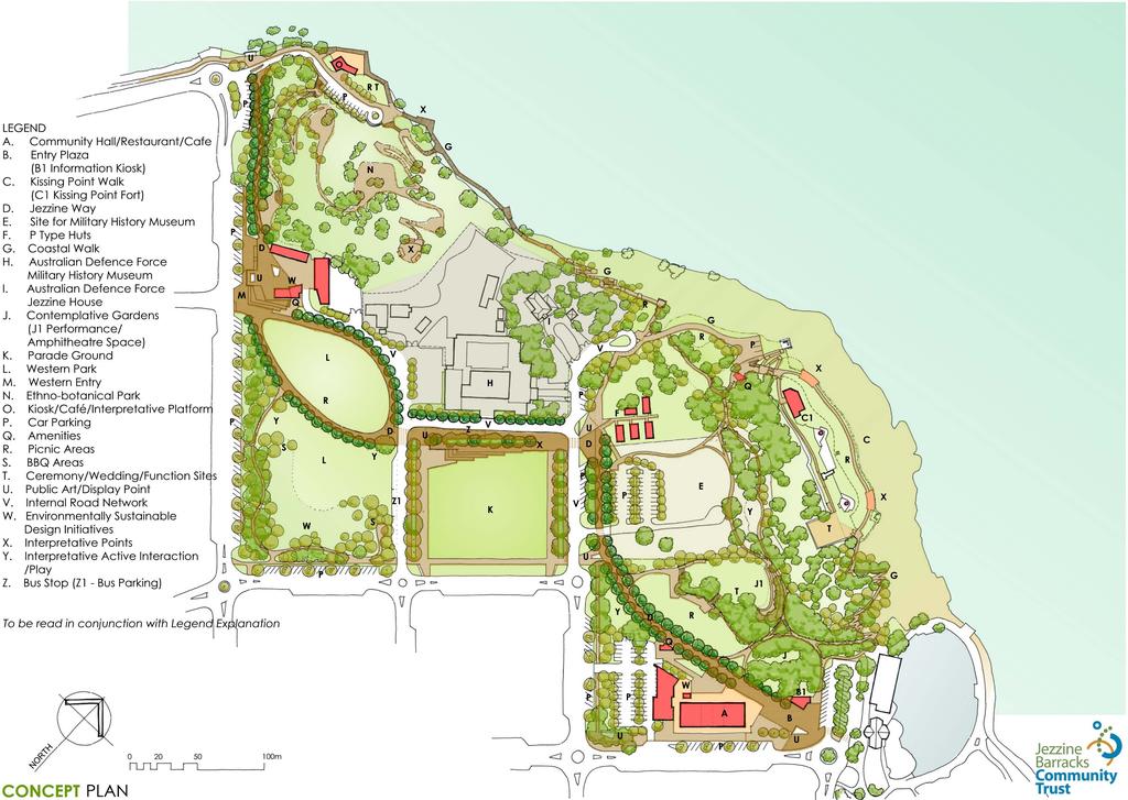
Legend Explanation CONCEPT PLAN
|
|
|
- Bathsheba Hood
- 5 years ago
- Views:
Transcription
1
2 Legend Explanation CONCEPT PLAN A. Community Hall Flexible Space with associated amenities and catering facilities Adjacent smaller community meeting spaces Raised podium with wide sheltered breakout spaces Restaurant/café at entry plaza edge Vehicle parking under B. Entry Plaza Defining entry and introducing identity of Jezzine Barracks Precinct Urban space leading to garden/open space Major art/military memorabilia location TCC information kiosk/facilities management office Public Amenities located on edge of this area C. Kissing Point Walk Coastal walk accessing Kissing Point Fort Links with Coastal Walk Enhance existing access path from Rockpool (redefine path and vegetation incorporating existing access) A more active/physical scenic path as an alternative to Jezzine Way Establish major way finding and interpretative points at vantage points atop Kissing Point using static and active display and interpretation methods Orientation Geographic Content Historical Content (Military/Social/Cultural) Traditional Owners Content (Bindal and Wulgurukaba) Incorporate new perimeter fencing and fencing to fort structure Design incorporating safe environment principles (CPTDE) lighting, landscape design, surveillance, activity and accessibility etc ) applies to entire precinct D. Jezzine Way Passes through centre of site providing direct linkage to Strand and Rowes Bay path networks Is an organising element skirting historical display points International Standard Military History Museum Townsville Social History Access to Kissing Point Fort Australian Defence Force Military Heritage Collection Parade Ground Historical Military Vehicles Display Defined by a distinct palette of materials, plantings and elements to signify main passage Linkages to all spaces and facilities within Jezzine Barracks Precinct
3 Legend Explanation CONCEPT PLAN E. Site for Military History Museum Significant location adjacent historical entry point to Jezzine Barracks and Jezzine Way path Large area incorporating car parking space/vehicular access for future international standard museum/interpretation facility F. P Type Huts Social/cultural heritage display Opportunity to display linkages of broader community with military context Recognise Historical Significance through adaptive reuse of existing building fabric and context G. Coastal Walk Links to Kissing Point and Fort walk Informal path around perimeter of site hugging land form, integrating with rock formations and remnant landscape/flora Incorporating boardwalk engaging with waters edge/tidal areas Sitting nodes along boardwalk information/rest/view areas Link to kiosk and Ethno-botanical Trail H. Australian Defence Force Military History Museum ADF retained facility and compound Controlled access for community I. Australian Defence Force Jezzine House Lavarack Barracks Commanding Officer s Official Residence ADF retained facility - private use by ADF J. Contemplative Gardens Reflective garden spaces utilising existing natural landforms and mature vegetation (supplemented with new landscaping) 2/3 distinct garden rooms Upper garden with amphitheatre terraces utilising natural contours and form of Kissing Point Potential for larger space to be utilised for occasional ceremonial/community/theatre group activities, functions etc Potential link as breakout/reflective space associated with future adjacent military history museum Proximate to amenities, access and vehicle parking areas Recognition of areas use by indigenous inhabitants of area
4 Legend Explanation CONCEPT PLAN K. Parade Ground Formalise and define edges Maintain open character of space and visual linkages with other areas with precinct Utilise slight fall in site to make low sitting terraces on upper edge of parade ground Provide discrete services to site perimeter (primarily electricity and water) for various activities/events to make use of Space used for periodic and occasional activities: Marshalling for Anzac Day and other military parades Military Parades and re-enactments/displays (vehicles, equipment, activities) Markets and other community events (Tattoos, concerts etc) L. Western Park Open Park Playground facility Open landscape, grass mounds Informal play field Provision of shade vegetation and shade structures Provision of BBQ s, tables etc in specific discrete locations Indigenous Landscape Incorporate indigenous vegetation of varying scales Encourage retention and incorporation of indigenous native flora and fauna Potential stormwater capture, retention and re-use (treatment through natural filter systems) reliant on seasonal fluctuations Informal landscaping linking along Cook St to Ethno-botanical Park (also acting as a buffer to established residences) contextual continuity Site sensitive design reflecting dry tropics environment(coastal, seasonal lagoon landscapes) and exemplifying sustainable and contextual landscape M. Western Entry Utilise podium created by Belman Hanger (Hanger removed structural safety issue) Create a small plaza with flanking shade structures, community facilities and building Shelters and Building multi-use facility for community and heritage group use and public access Military Heritage Vehicle Groups Traditional Owner Groups (Bindal and Wulgurukaba) (potentially in association with adjacent Ethno-botanical Trail) Community Groups Small events/functions/activities Eastern edge defined by TCC Building and Public amenities (maintenance depot facility located behind) Major Public Art to identify and establish character of precinct and plaza area Occasional authorised vehicle access from Cook Street (shared with Jezzine Way) Primary depot access from internal road network (off one-way loop)
5 Legend Explanation CONCEPT PLAN N. Ethno-botanical Park Indigenous Flora/ Bush-tucker /Traditional Owner (Bindal and Wulgurukaba) Cultural History Trail Trail integrated with natural land forms low impact Encourage retention and incorporation of native flora and fauna Enhance existing remnant vegetation and establish areas of new indigenous vegetation Several access points to trail from Jezzine Way, Coastal Path/boardwalk At pinnacle of path (and land form) establish major way finding and interpretative points using static and active display and interpretation methods Orientation Geographic Content Historical Content (Military/Social/Cultural) Traditional Owner Content Link with shared community facility at Western Entry (Cook Street) O. Kiosk Broad partially covered decks/terrace taking advantage of location view, waters edge, Magnetic Island/Cape Palleranda/Many Peaks Range etc) Small Kiosk (permanent/temporary facility service points provided) Grass picnic terrace beside waters edge/boardwalk (potential small outdoor function/wedding location) Lane for access and service with parking adjacent Connection with Coastal Walk pathway around southern side and boardwalk on northern side (boardwalk constructed slightly lower than adjacent terrace/deck to maintain access to view Kiosk could be operated in conjunction with organised tours of Ethno-botanical Trail P. Car Parking Perimeter on-street parking 101 vehicle spaces (plus motorcycles) Proximate to specific areas Assists in defining Jezzine Barracks site edge and formalise/soften edges with landscaping Maintain significance of parade ground with no parking in heritage cartilage area Internal Parking 171 vehicle spaces (plus motorcycles and bicycles) Landscaped grove shade plantings Capture stormwater in under-parking are tanks for treatment/re-use in irrigation of parking area landscaping Numbers include 20 covered secure parking spaces for community hall 3 Bus parking spaces Define parking areas with distinct materials palette reduce asphalt look through use of pavement material/finish, colour and landscaping Provide approximately 12 PWD parking spaces spread across precinct and located proximate to major elements
6 Legend Explanation CONCEPT PLAN Q. Amenities Male/Female/PWD facilities Safety through the built environment principals applied clear surveillance, lighting etc. Potential for use of electricity generated from sustainable methods eg. Solar/wind in association with provision of these services and recycled water use/collection and use of alternative water supplies eg. Stormwater for toilet/urinal flushing R. Picnic Areas Grassed Areas Small grassed mounds to define some areas Shaded Area (natural shade) Waste Bins provided (Potentially custom designed - identifiable as part of elements used throughout precinct) S. BBQ Areas Discrete Areas provided with BBQ facilities Shaded Area (natural and shade structures) Furniture tables, benches BBQ shrouds, waste bins provided (Potentially custom designed - identifiable as part of elements used throughout precinct) T. Ceremony/Wedding/Function Sites Areas for outdoor ceremony/weddings/functions taking advantage of location and view Areas able to have degree of control over access Provision of discrete services to areas (primarily electricity and water) for various activities/events to make use of U. Public Art/Display Point Assist in establishing identity and understanding of precinct and distinct areas within precinct Located at pathway nodes, with building settings and garden spaces Built in and freestanding works Military Objects (Vehicles, Artillery etc)
7 Legend Explanation CONCEPT PLAN V. Internal Road Network One-way loop around Parade Ground Secondary access to various areas off main loop Western Entry (and TCC maintenance depot) Jezzine House ADF Military Heritage Facility Kissing Point Fort access shared with pedestrians intermittent use by service/maintenance vehicles and to provide equitable access to the Fort for older persons/persons with a disability Parking and service lane to Restaurant/Café Pockets of internal car parking spread within site for amenity and direct access to facilities W. Environmentally Sustainable Design Initiatives Potential for use of alternative supplies for Water Stormwater, Grey Water collection, treatment and re-use Electricity Solar and Wind electricity generation Efficient fittings and fixtures water use, light provision Provision of discrete service through the site (associated with main paths and likely activities to occur with areas) secure access points Durable low maintenance selections Systems and materials selections made on reduced on-going operation/life-cycle costs, recycled/renewable resource content and future recycling ability Opportunity for community education through interaction and interpretative use of ESD initiatives and understanding of relevant eco-systems (coastal and suburban environments) Use of indigenous flora (and encouragement/retention of fauna) suited to context X. Interpretative Points Establish major way finding and interpretative points at vantage points atop Kissing Point using static and active display and interpretation methods Orientation Geographic Content Historical Content (Military/Social/Cultural) Traditional Owner Content Ecology Locate at vantage points on Jezzine Way, Kissing Point Walk, Kissing Point Fort, Parade Ground, Cook St and Esplanade intersection Establish other points at locations, items of interest Unified approach across precinct assist in establishing Jezzine Barracks identity.
8 Legend Explanation CONCEPT PLAN Y. Interpretative Active Interaction/Play Establish interactive low key way finding and interpretative points through barracks precinct which allow younger members of the community the opportunity to access and interpret information related to military, cultural and Traditional Owners (Bindal and Wulgurukaba) history of the site through activity Design incorporated with other precinct elements to help establish, project and reinforce Jezzine Barracks and Kissing Point identity Z. Bus Stop Bus drop off and pick up area Part of Public Transport network Area for tour/school bus use Shade (natural and low key integrated structure) and seating Parking for 3 large buses on site associated with internal road loop
9
10
11
12
13
14
15
16
17
Next Steps / Development Process. Structure Plan. June submitted to City of Fremantle. Structure Plan. July supported for advertising
 overview What is today about? In July 0, the City of Fremantle resolved that the be advertised for public comment. Today is about: Understanding the history and context of the site Having your say on the
Mixed Use Centres Development Permit Guidelines
 1 Mixed Use Centres Development Permit Guidelines Area Commercial or Mixed Use development occurring in City Centre, Urban Centre, Neighbourhood Centre, or Institutional Complex land use designations is
H7 Open Space zones. (a) provide for the needs of the wider community as well as the needs of the community in which they are located;
 provide for the needs of the wider community as well as the needs of the community in which they are located;") H7. Open Space zones H7.1. Background The majority of land zoned as open space is vested in the Council or is owned by the Crown. However some areas zoned open space are privately owned. While the open
H7. Open Space zones H7.1. Background The majority of land zoned as open space is vested in the Council or is owned by the Crown. However some areas zoned open space are privately owned. While the open
CURL CURL BEACH LANDSCAPE DRAFT MASTERPLAN
 LANDSCAPE 03 04 05 07 06 08 LANDSCAPE KEY BENEFITS OPEN SPACE EXISTING = 25600m2 PROPOSED = 29000m2 NATURAL/LANDSCAPED AREA EXISTING = 36200m2 PROPOSED = 38450m2 PARKING SPACES MAIN CAR PARK EXISTING =
ELEMENT 16 - LANDSCAPE DESIGN GUIDELINES ELEMENT
 16 ELEMENT 16 - LANDSCAPE DESIGN GUIDELINES ELEMENT Goal 1 To establish an overall landscape character that provides: A pedestrian friendly environment that provides ample tree canopy and shade. An overall
ROSENTHAL CARPARK LIFE BETWEEN BUILDINGS IN LANE COVE
 south square Life between buildings includes all the very different activities people engage in when they use common city space; purposeful walks from place to place, promenades, short stops, longer stays,
PHASE 3-4 PARKS SOUTH PARK AND CHANNEL PARK
 PHASE 3-4 PARKS SOUTH PARK AND CHANNEL PARK Sheet List L1.0 L2.0 L3.0 L4.0 L5.0 L6.0 L7.0 L8.0 L9.0 L10.0 L11.0 L12.0 L13.0 L14.0 L15.0 L16.0 L17.0 L18.0 L19.0 L20.0 L21.0 L22.0 Cover Open Space Context
FRUITVALE TRANSIT VILLAGE (Phase 2) Residential Project
 Residential Project") FRUITVALE TRANSIT VILLAGE (Phase 2) Residential Project DEVELOPER: SIGNATURE PROPERTIES ARCHITECT: HKIT ARCHITECTS April 23, 2010 TABLE OF CONTENTS 3 Vision 4 Description of Site 5 Guiding Concepts 6
FRUITVALE TRANSIT VILLAGE (Phase 2) Residential Project DEVELOPER: SIGNATURE PROPERTIES ARCHITECT: HKIT ARCHITECTS April 23, 2010 TABLE OF CONTENTS 3 Vision 4 Description of Site 5 Guiding Concepts 6
Port Macquarie Town Centre Landscape Architects
 Port Macquarie Town Centre Town Green Master Plan Review Tract Landscape Architects Urban Designers Town Planners A review of the Town Green Master Plan Port Macquarie, New South Wales Prepared by Tract
ANCHOR TO ANCHOR. Rescale the street to create an iconic boulevard.
 ANCHOR TO ANCHOR Rescale the street to create an iconic boulevard. UR NE ER UV GO NE LA OBJECTIVES 1. Maintain appropriate traffic flow and prioritize commercial curb access 2. Mark gateways at the street
4.2 Ecological Principles
 4.2 Ecological Principles Introduction The overall character of the campus is one of open woodland in which locally and regionally indigenous tree species predominate. The colours, textures and quality
Section 12C Subdivision in the Rural Residential Zone
 Section 12C 12C Subdivision in the Rural Residential Zone The Rural Residential Zone provides part of the range of residential opportunities within the City. Land zoned rural residential is considered
9.4.2 Landscape code 9
 9.4.2 Landscape code 9 9.4.2.1 Application (1) This code applies to assessable development identified as requiring assessment against the Landscape code by the tables of assessment in Part 5 (Tables of
Courthouse Square Planning & Urban Design Study. Courthouse Square Working Group #13 October 15, 2014
 Courthouse Square Planning & Urban Design Study Courthouse Square Working Group #13 October 15, 2014 1 Courthouse Square Process Working Group Community Courthouse Square Advisory Groups & Civic Associations
Landscape and Streetscape Design 2.5
 Landscape and Streetscape Design 2.5 2.5.1 Goals 2.5.2 Planting 2.5.3 Sidewalks and Pavement 2.5.4 Furnishings 2.5.5 Walls 2.5.6 Lighting 2.5.7 Stormwater 2.5.8 Street Cross Sections 2.5 LANDSCAPE AND
CANOPY AT AMSTEL (THE AMSTEL GOLF COURSE REDEVELOPMENT)
") CANOPY AT AMSTEL (THE AMSTEL GOLF COURSE REDEVELOPMENT) 1000 CRANBOURNE FRANKSTON ROAD, CRANBOURNE The former Amstel Golf Course was rezoned to a General Residential Zone in 2015 to facilitate its redevelopment
CANOPY AT AMSTEL (THE AMSTEL GOLF COURSE REDEVELOPMENT) 1000 CRANBOURNE FRANKSTON ROAD, CRANBOURNE The former Amstel Golf Course was rezoned to a General Residential Zone in 2015 to facilitate its redevelopment
VEHICULAR AND PEDESTRIAN CIRCULATION
 This perspective sketch communicates the intended character and quality of a proposed streetscape design. Locate benches near a major intersection where people tend to gather. Seating and lighting provide
PCAL Case Study Open Spaces: Blayney Heritage Park
 PCAL Case Study Open Spaces: Blayney Heritage Park Introduction Blayney Heritage Park is an area of high quality open space that offers a range of active and passive recreation facilities. The multi-purpose
VICTORIA PARK / BAKKABAKKANDI COMMUNITY RECREATION PARK CONCEPT MASTER PLAN. November 2008
 CONCEPT MASTER PLAN November 2008 EXECUTIVE SUMMARY Concept Master Plan Summary Concept Master Plan Outline Plan Concept Master Plan Perspectives SECTION ONE - BACKGROUND Context Existing Site Existing
Clairtrell Area Context Plan
 Clairtrell Area Context Plan March 2005 Urban Development Services City Planning Contents 1. Introduction... 4 2. Development Structure... 6 2.1 Streets... 7 2.1.1 Sheppard Avenue and Bayview Avenue...
UNIVERSITY TOWN NEIGHBOURHOODS 5.2 ECO-CORRIDOR MELBOURNE CAMPUS MASTER PLAN 2014
 5.2 ECO-CORRIDOR 37 ECO-CORRIDOR EXISTING CONDITIONS & VISION NEIGHBOURHOOD VISION Investment in the Eco-corridor Neighbourhood will signify the University s commitment to supporting local ecology and
Section 4 - Public Realm & Landscape proposals Landscape Masterplan. Section 4 52
 - Public Realm & Landscape proposals Landscape Masterplan 52 Proposed Masterplan - Green Infrastructure Strategy District Park 4.33 Ha to provide Passive and active recreation with a large play area which
Monte Cecilia Park DRAFT CONCEPT PLAN FEBRUARY 2015 AUCKLAND COUNCIL
 Monte Cecilia Park DRAFT CONCEPT PLAN FEBRUARY 2015 AUCKLAND COUNCIL 1 Site analysis and concept 1.1 Location Site Extent MT ALBERT RD HILLSBOROUGH RD BUDOCK RD MONTE CECILIA PARK KORMA RD HERD RD Figure
Proposed Pedestrian and Cycle Routes. Headland to Spit Great Ocean Walk and coastal path network* (Regional scale path)
") four strategies access and movement The access and movement strategy for the Master Plan aims to promote healthy, active and sustainable movements to and through Mooloolaba. Pedestrian and Cycle A lack
four strategies access and movement The access and movement strategy for the Master Plan aims to promote healthy, active and sustainable movements to and through Mooloolaba. Pedestrian and Cycle A lack
Dowdy Park. Concept Plans TOWN OF NAGS HEAD NORTH CAROLINA. Developed by: Albemarle & Associates, Ltd VHB/ Vanasse Hangen Brustlin, Inc.
 TOWN OF NAGS HEAD NORTH CAROLINA Concept Plans Developed by: Albemarle & Associates, Ltd VHB/ Vanasse Hangen Brustlin, Inc. Site Looking Southeast Dowdy Park Existing Conditions Nags Head Woods Sound Future
3.0 master plan concept
 3.0 master plan concept 3.1 introduction The purpose of the Huron Church Road Master Plan Concept is to provide an overview of the Master Plan design process, identify preliminary streetscape installations
RIVERSIDE DESIGN CD-1 GUIDELINES. Adopted by City Council August 9, 1983
 $1 City of Vancouver Land Use and Development Policies and Guidelines Community Services, 453 W. 12th Ave Vancouver, BC V5Y 1V4 F 604.873.7344 fax 873.7060 planning@city.vancouver.bc.ca RIVERSIDE DESIGN
The Vision. Photo provided by The Minervini Group. 46 Vision, Objectives & Strategies
 Vision, Objectives & Strategies The is the public framework and guide for future development of the Grand Traverse Commons. The establishes public polices for infrastructure, the preservation of natural
Implementation plan. 3.1 Staging
 3 Implementation plan 3.1 Staging The Olympic Park Master Plan has been developed to provide actions that are practical and realistic and considers the financial responsibilities and capacity of Council
GREENBANK DEVELOPMENT MASTERPLAN
 DEVELOPMENT MASTERPLAN POTENTIAL TRAIN STATION COMMUNITY CENTRE Greenbank will be a connected masterplanned community providing easy access to local and surrounding amenity. Affordable quality homes, green
Seneca Meadows. Block 4 Locate office, technology, and medical development adjacent to I Screen views of garage structures from I-270.
 Seneca Meadows Seneca Meadows has an industrial park in its southern end and a mixed-use employment area planned for the north end. The district benefits from extensive I-270 visibility, stream valley
4.3 Dudley Area Plan. Introduction. History and Existing Character. Desired Future Character for Dudley
 4.3 Dudley Area Plan Introduction The suburb of Dudley has developed as a result of various circumstances including its topography, history and mineral resources. Dudley development has been identified
GREENVALE CENTRAL PRECINCT STRUCTURE PLAN
 76 Conservation area boundary. Low Fence to exclude vehicles but allow pedestrian access Front boundary of allotment 5.0m MINIMUM SETBACK Path providing public access to dwellings fronting Conservation
39 WALLACEVILLE STRUCTURE PLAN
 39 WALLACEVILLE STRUCTURE PLAN PRECINCT DESCRIPTIONS, INTENTIONS AND OUTCOMES Wallaceville Living Precinct Area A At approximately 13.4ha, this precinct is the largest precinct and the precinct provides
Appendix H: Easement cross sections
 Appendix H: Easement cross sections SHARED PATH 1.5m FOOTPATH NATURE STRIP 7.3m CARRIAGEWAY 2.7m NATURE STRIP EXISTING PIPELINE 150mm DIA 5.0m (approx.) LOCAL ACCESS ROAD EXISTING PIPELINE 500mm DIA 2.7m
2011 ASLA Design Awards. Centennial Park Merit Award Design Concepts CLA, Inc. Design over $500,000 Construction Budget
 2011 ASLA Design Awards Centennial Park Merit Award Design Concepts CLA, Inc. Design over $500,000 Construction Budget 2011 ASLA Colorado Professional Design Awards Project Name: Category: Location: Const.
I615. Westgate Precinct
 I615. Westgate Precinct I615.1. Precinct Description The Westgate Precinct is located approximately 18km west of the Auckland city centre. There are seven Sub-precincts in the Westgate Precinct: Sub-precinct
ELMVALE ACRES SHOPPING CENTRE MASTER PLAN
 ELMVALE ACRES SHOPPING CENTRE MASTER PLAN Contents 1.0 INTRODUCTION... 2 2.0 LOCATION... 2 3.0 EXISTING CONTEXT... 2 4.0 VISION & GUIDING PRINCIPLES... 2 5.0 LAND USE AND BUILT FORM... 4 5.1 St. Laurent
97 Lea Bridge Road, Leyton, E10 7QL London Borough of Waltham Forest December 2015
 97 Lea Bridge Road, Leyton, E10 7QL London Borough of Waltham Forest December 2015 Public Realm and Landscape Proposals LEA BRIDGE ROAD, WALTHAMSTOW Public Realm & Landscape Proposals BDP(90)RPT001 December
2.5 Roads. Loading and service areas adjacent to Highway 401 should be screened through architectural walls and/or landscape buffer planting.
 N HIGHWAY OFF RAMP 2.5 Roads A legible road network with a clear hierarchy will help create a connected community, both within and surrounding the Milton Heights. The following section outlines the proposed
Neighborhood Districts
 NEIGHBORHOOD DISTRICTS SEVEN MAIN DISTRICTS Neighborhood Districts While the Development Plan provides a broad-scale overview of the neighborhood, this section focuses on uses and relationships at the
Stage 3 Consultation Summary
 STAGE STAKEHOLDERS ENGAGEMENT CAMPUS MASTER PLAN THE CHINESE UNIVERSITY OF HONG KONG Stage Consultation Summary Master Planning for a Sustainable Campus The Chinese University of Hong Kong is well-known
Standards (R-3) Figure B-11: R-3 Residential Standards Exhibit
 Figure B-11: R-3 Residential Standards Exhibit") Avila Ranch Avila Ranch Specific Plan Development Standards High Medium Density - High Residential Density Residential Lot and Building Lot and Standards Building (R-3) Standards (R-3) EXAMPLES These sketches
Avila Ranch Avila Ranch Specific Plan Development Standards High Medium Density - High Residential Density Residential Lot and Building Lot and Standards Building (R-3) Standards (R-3) EXAMPLES These sketches
project background relationship to the spit Guiding Principles Mooloolaba Spit Futures Plan (2009) Vision one
 Vision one") one project background relationship to the spit The Spit is an important part of Mooloolaba and a key contributor to the natural beauty of the town. The Spit is cherished by local residents and visitors
one project background relationship to the spit The Spit is an important part of Mooloolaba and a key contributor to the natural beauty of the town. The Spit is cherished by local residents and visitors
Walnut Creek BART Station
 Walnut Creek BART Station Mixed Use Transit Oriented Project Design Review Commission Study Session May 17, 2006 Applicant: Walnut Creek Transit Lifestyles Associates Joint Venture: Transit Village Associates
Memorial Business Park Site. Proposed Future Development. Design guidelines. August
 Memorial Business Park Site Proposed Future Development Design guidelines August 2014 www.designenvironment.co.nz 0064 3 358 3040 Contents 1.0 Background 1.1 Introduction 3 1.2 Objectives 4 2.0 Context
Executive Summary Public Space / Community Space
 Executive Summary This discussion paper suggest how the concept of Public Space/Community Space, set out by the Callan Park Taskforce, can be first understood and then applied to Callan Park. This paper
Highland Village Green Design Guidelines
 Highland Village Green Design Guidelines Publishing Information Title Highland Village Green Design Guidelins Author The City of Calgary Status DRAFT - Proposed document subject to changes Additional Copies
Queensborough Eastern Neighbourhood Node. Community Open House
 Queensborough Eastern Community Open House The Vision The Queensborough Eastern will become the heart of eastern Queensborough. Through a sensitive mix of viable commercial and residential areas, the neighbourhood
5.0 P A R K R E C O M M E N D A T I O N S
 5.0 P A R K R E C O M M E N D A T I O N S 5.1 Confederation Park The analysis of Confederation Park recognizes that it, along with City Hall, is the symbolic heart of Kingston. While the existing layout
MCCOYS CREEK RESTORATION 30% DESIGN
 MCCOYS CREEK RESTORATION 30% DESIGN THE MCCOYS CREEK RESTORATION PLAN The restoration plan aims to reduce flooding, restore ecosystem health, expand recreational opportunities along the creek, and connect
PROJECT SITE The Proposed Project includes the Allen and Pike Street malls between Delancey and South Streets (see Figure 2C-1).
.") Chapter 2, Section C: A. INTRODUCTION This chapter considers the potential of the proposed Reconstruction of the Allen and Pike Street Malls project to affect the urban design characteristics and visual
Chapter 2, Section C: A. INTRODUCTION This chapter considers the potential of the proposed Reconstruction of the Allen and Pike Street Malls project to affect the urban design characteristics and visual
I539. Smales 2 Precinct
 I539. Smales 2 Precinct I539.1. Precinct Description The Smales 2 Precinct applies to a 4.8 hectare block of land located on the southern side of Northcote Road and fronting Lake Pupuke, Takapuna. The
New Park / Entry Court & Plaza Concept Design
 New Park / Entry Court & Plaza Concept Design The SECC Public realm is proposed to have a focus on health, wellness, and community and that site users will include patrons of the neighbourhood. The block
heuston gateway: sections heuston gateway: regeneration strategy and development framework plan
 B B1 A B1 B C A heuston gateway: sections B B1 C 117 4.3.3 Zoning The station is the central hub of the area and this function must be preserved and developed. However large areas of the Heuston Station
DESIGN REPORT & ARCHITECTURAL DRAWINGS. DONOVAN HILL THE HIVE Noosaville - 980
 DESIGN REPORT & ARCHITECTURAL DRAWINGS NOOSA DEVELOPMENT 37 GIBSON ROAD NOOSAVILLE DEVELOPMENT APPLICATION OCTOBER 2010 Issue B 22/10/2010 Architectural Design Report Background The scheme replaces an
Types of Reserves. Recreational activities
 VALLEY FLOOR AND EASTERN HILLS Physical and ecological features Large, flat valley floor and river plain with intensive urban development Hutt River / Te Awa Kairangi and tributaries Waiwhetu Stream Eastern
ILLUSTRATIVE MASTERPLAN
 ILLUSTRATIVE MASTERPLAN The Development Dairy Crest (Imperial College) The Proposed Development aims to create a new high quality residential neighbourhood, alongside a new public park for White City.
PLANNING RATIONALE FOR THE PROPOSED RIVERSIDE SOUTH ELEMENTARY SCHOOL 715 BRIAN GOOD AVENUE, OTTAWA, ON
 PLANNING RATIONALE FOR THE PROPOSED RIVERSIDE SOUTH ELEMENTARY SCHOOL 715 BRIAN GOOD AVENUE, OTTAWA, ON Conseil des écoles publiques de l'est de l'ontario (CEPEO) French Public School Board TABLE OF CONTENTS
Four Big Ideas. Three Key Opportunities. Principles. Draft Place Making Master Plan. 1. The Foreshore 2. Green Links. 3.
 project background Four Big Ideas 1. The Healthy Thriving Place. An International Focus 3. Reclaiming Mooloolaba 4. The Resort Heart of the Coast In November 01 a big ideas workshop was held involving
Sub Area 2: Downtown Overland Park
 Downtown 132 2.12 encompasses over 600 acres and extends between 71st Street and 87 th Street including Downtown Overland Park. The area is home to several individual historic sites and structures, including
BURTON STATION STRATEGIC GROWTH AREA PLAN UPDATE PUBLIC MEETING 3/26/18
 BURTON STATION STRATEGIC GROWTH AREA PLAN UPDATE PUBLIC MEETING 3/26/18 1 WHERE WE ARE? 2 PRIMARY OBJECTIVES OF THE PLAN UPDATE 1. Update the land use designation for Burton Station Village to reflect
The open space system should provide connective elements, relate to natural resources, and enhance the suburban character of the landscape..
 The open space system should provide connective elements, relate to natural resources, and enhance the suburban character of the landscape.. Mixed-use and infill development should maintain or enhance
Corridor Identity. Section 9. Introduction. Corridor Guiding Principles
 Corridor Identity An attractive and healthy community is a critical element of a quality place, and the design of quality places is a balance between environmental, economic, and social considerations.
Reconnecting to a Forgotten River St. Cloud MN. Aaron Hanson Design Design Thesis LA 572, Thesis, Spring 2012
 Reconnecting to a Forgotten River St. Cloud MN Aaron Hanson Design Design Thesis LA 572, Thesis, Spring 2012 site context 2.5 Miles Sartell St. Cloud to Fargo 170 Miles (2 hrs 45 mins) Hwy 10 infrastructure
REMARKABLES PARK ZONE
 .10 Remarkables Park Zone.10.1 Resources, Activities and Values The Remarkables Park Area comprises approximately 150 hectares of perimeter urban land in the vicinity of Frankton and occupies a strategic
ADELAIDE COMETS CLUBROOMS DESIGN CONCEPT
 PREPARED FOR Adelaide Comets FC Tampawardli Park (Ellis Park) Lot 587 West Terrace Adelaide SA 5000 P +61 8 8333 9796 ATTENTION Jim Tsouvalas P +61 8 8231 1885 E webmaster@adelaidecomets.com.au PREPARED
4. MASTERPLAN FRAMEWORK
 6a 6b 4. MASTERPLAN FRAMEWORK 6. Car Parks 6c Car Parks 6a and 6b will provide permanent parking. Area 6a will serve the foodstore with tarmac surfacing within a defined area to the west of the adjacent
Urban Design Brief to 1557 Gordon Street & 34 Lowes Road West
 Urban Design Brief 1533 to 1557 Gordon Street & 34 Lowes Road West Reid s Heritage Homes Ltd. & 883928 Ontario Ltd. and RHH Property Management Ltd. City of Guelph Zoning By-law Amendment November 2017
DUNDAS TRAFALGAR DUNDAS TRAFALGAR. (North Oakville) (NORTH OAKVILLE) Urban Design Brief. Urban Design Brief. Prepared by: NAK Design Strategies
 (NORTH OAKVILLE) Urban Design Brief. Urban Design Brief. Prepared by: NAK Design Strategies") DUNDAS TRAFALGAR (NORTH OAKVILLE) Urban Design Brief DUNDAS TRAFALGAR (North Oakville) Urban Design Brief Prepared by: NAK Design Strategies Prepared for: Dundas Trafalgar Inc. December 2014 TABLE OF
DUNDAS TRAFALGAR (NORTH OAKVILLE) Urban Design Brief DUNDAS TRAFALGAR (North Oakville) Urban Design Brief Prepared by: NAK Design Strategies Prepared for: Dundas Trafalgar Inc. December 2014 TABLE OF
Town Center. Block 5 Existing multifamily residential units are expected to remain.
 Area Guidelines Germantown s districts should be developed as distinct communities with unique features that are supported through the guidelines. The guidelines not only help distinguish these districts
Gas Stations ottawa.ca
 Urban Design Guidelines for Gas Stations ottawa.ca Ce document est disponible en français sur ottawa.ca. This document is available in French on ottawa.ca. Approved by City Council May 24, 2006 City of
GISBORNE PLAYGROUND UPGRADE STRATEGY
 GISBORNE PLAYGROUND UPGRADE STRATEGY OPUS LANDSCAPE ARCHITECTURE 06 MARCH 2014 CONTENTS CONTENTS 1. Introduction and Location Plan 2. Playspace Design Principles 3. Playspace Design Considerations 4. Condition
Building and Site Design Standards
 Commercial Design Standards All Business and Industrial Uses as Described in Section 2234 Requiring Special Permit Review Except Large-Scale Ground Mounted Solar Photovoltaic Installations and Wireless
Chapter 4: Jordan Road Character District
 4: Jordan Road Character District 4.1 Introduction The Jordan Road character district encompasses much of the former Jordan orchard and farmstead, which was a significant part of Sedona s history. The
Community Design Guidelines. Port Wallace DRAFT
 Community Design Guidelines Port Wallace DRAFT Energy 1 2 3 Nature Movement Connections Built Form DRAFT Layout Energy 1 Nature Community Design Guidelines GREAT COMMUNITIES PROTECT, CELEBRATE, AND CONSERVE
14-18 Gallway St, Windsor. Revision D
 Revision D The Gallway Street Landscape Design Intent: The overall planting design intent: is to be a native, resilient, sub-tropical collection of species. The arrangement to the front entry space will
PUBLIC RIGHT-OF-WAY IN THIS CHAPTER PUBLIC REALM
 PUBLIC RIGHT-OF-WAY This section provides design guidelines for improvements in the public right-of-way. The public right-of-way refers to streets, sidewalks, non-vehicular thoroughfares, parks and greenways
Regional Urban Design Guidelines
 Regional Urban Design Guidelines Interactive Website Online: http://www.designfortord.org Compliance Checklist FORT ORD REUSE AUTHORITY 6/10/2016 6/10/2016 Table of Contents Purpose... 3 How to Use This
Wide asphalt driveway abutting school property. garage built with incompatible materials, too close to park. incompatible fencing materials
 Wide asphalt driveway abutting school property incompatible fencing materials garage built with incompatible materials, too close to park Lack of plantings as a buffer between private property and open
City of Langford Green Development Checklist
 City of Langford Green Development Checklist The following Green Development Checklist creates a sustainability standard for all comprehensive development within the City of Langford. The commitments made
7-PARKS, OPEN SPACE & PUBLIC ART
 7-s, Open Space & Public Art 7-PARKS, OPEN SPACE & PUBLIC ART This chapter provides recommendations for the expansion of new parks, plazas and open space that serve the many user groups targeted for downtown.
Background Information
 Background Information view at site entrance THE LONDON BOROUGH OF SUTTON As the strategic local authority the Council is working with a range of partners to take forward various development sites in Hackbridge.
SECTION ONE North East Industrial Zone Design Guide Palmerston North City Council June 2004
 SECTION ONE North East Industrial Zone Design Guide Palmerston North City Council June 2004 young heart easy living 1 Preface Industrial areas are a very important component of the economic well-being
SCHEDULE 12 TO THE DESIGN AND DEVELOPMENT OVERLAY GLEN WAVERLEY ACTIVITY CENTRE STRUCTURE PLAN
 DD/MM/YY Proposed C120 SCHEDULE 12 TO THE DESIGN AND DEVELOPMENT OVERLAY Shown on the planning scheme map as DDO12. GLEN WAVERLEY ACTIVITY CENTRE STRUCTURE PLAN 1.0 Design objectives DD/MM/YY Proposed
8.2 Sector 2 Kelburn Park
 8.2 Sector 2 Kelburn Park Kelburn Park, near Victoria University 8.2.1 Character and use Kelburn Park is a sector of the Town Belt, of a scale and character more like a suburban park. However, the woodland
WEST BLACKHALL STREET PUBLIC REALM + TOWN CENTRE CONNECTIONS Public Exhibition 28 th June 2018
 WEST BLACKHALL STREET PUBLIC REALM + TOWN CENTRE CONNECTIONS Public Exhibition 28 th June 2018 Welcome Introduction Design Your Involvement Thank you for coming Engagement We would like to gather to this
3.1 community vision. 3.3 required plan elements
 Chapter 3 Community Form 3.1 community vision 3.2 Parks & landscaping concepts 3.3 required plan elements D R A F T 20 Community Form Chapter 3 3.0 Community form 3.1 community vision The Specific Plan
Design Specifications & Requirements Manual
 11 PARKS & OPEN SPACES 11.1 DEFINITIONS... 1 11.1.1 Neighbourhood Parks... 1 11.1.2 District Parks... 1 11.1.3. Sport Parks... 1 11.1.4 Urban Parks... 1 11.1.5 Civic Spaces... 1 11.1.6 Open Space System...
10 Proposed Redevelopment, Tewkesbury Road, Cheltenham SCHEME EVOLUTION STARBUCKS
 SCHEME EVOLUTION STARBUCKS The proposed Starbucks Drive Thru alongside the proposed food store provides an appropriate mix of uses, suitable for this location. The proposed store is bespoke, designed specifically
AIRPORT BUSINESS PARK
 PIER MAC PETROLEUM INSTALLATION LTD. AIRPORT BUSINESS PARK DEVELOPMENT APPLICATIONS March 2003 4.1 Airport Business Park Development Permit Area 4.1.1 Justification/Design Concept The design concept envisioned
7. Biodiversity & Conservation Areas
 7. & Conservation Areas 7.1. Objectives The objectives of biodiversity and conservation areas are founded on the need to recognise the importance of biodiversity and acknowledge the need to protect, restore
WILLASTON PLAYSPACE // OPTION 1.1 LEGEND P r o je ct No. 18WOP / SCALE / Date of Issue
 WILLASTON PLAYSPACE // OPTION. P r o je ct No. WOP / :00@A / Date of Issue.0. Significant distance from other recreation facilities Visually disconnected from other facilities in precinct Access to services
EXISTING CONDITIONS 41. Existing Conditions
 EXISTING CONDITIONS 41 Existing Conditions The Existing Analysis phase of the planning process involved a study of the existing conditions on the campus in order to identify key planning issues to be addressed
4 Semi-Private & Private Open Spaces
 4 Semi-Private & Private Open Spaces 4.1 Semi-private Open Space 4.1.1 Common Courtyards The common courtyards for each complex will be designed and programmed for the typical owners living there. They
TIER ONE - CMI URBAN DESIGN OBJECTIVES
 TIER ONE - CMI URBAN DESIGN OBJECTIVES V I S I O N TO CREATE A MOTORWAY CORRIDOR THAT: makes a positive contribution to city-wide connectivity and the urban fabric of Auckland is visually stimulating and
MASTERPLAN AND PARK IMPROVEMENTS
 ST.JAMES PARK MASTERPLAN AND PARK IMPROVEMENTS Stakeholder Meeting 3 April 26, 2016 Team: PMA Landscape Architects Ltd. Lead Landscape Architects MASS LBP Public Facilitation Consultant RAW Design Architectural
MASTER CHECKLIST. February 2014 Version 1.2
 February 2014 Version 1.2 Strategies for creating healthy active developments The following master checklist has been prepared as a tool to provide developments that encourage and support physical activity
Development Control Plan
 Development Control Plan Liberty Grove Development Control Plan Date of Adoption: 4 September 2007 Effective Date: 7 March 2008 Index 1 INTRODUCTION... 3 1.1 NAME OF PLAN... 3 1.2 AREA TO WHICH THIS PLAN
lot flankage Y street 16m 6m landscape strip for large site 3m landscape strip for small medium site
 Commercial General Commercial Objectives Create developments compatible with adjacent land uses in scale, function and character Define a consistent and attractive street edge with quality landscaping,