Streetscape and Public Realm Design Guidelines Streetscape Design Implementation for the Communities of the Town of East Gwillimbury
|
|
|
- Leonard Powell
- 5 years ago
- Views:
Transcription


1 Streetscape and Public Realm Design Guidelines Streetscape Design Implementation for the Communities of the Town of East Gwillimbury (Progress Draft) August 2015
2 Table of Contents 1.0 Introduction 1.1 The Public Realm 1.2 Purpose of the Document 2.0 Background Information/Context for the Guidelines 2.1 Urban Design Goals. 2.2 East Gwillimbury Guiding Documents 2.3 Community Themes 2.4 Areas of Prominence 3.0 Town-wide Design 3.1 Streetscape Design Themes 3.2 Arterial Roads of Regional and Local Corridors Green Lane Corridor Leslie Street at Sharon Village Core Queensville Centre Mt. Albert Village Core Holland Landing Village Core 3.3 Local Road Heirarchy Major Collector Roads Local Collector Roads Local Roads 4.0 The Communities of East Gwillimbury Design Details and Guideline Illustrations 4.1 General Standards 4.2 Sharon Design Theme 4.3 Queensville Design Theme 4.4 Holland Landing Design Theme 4.5 Mount Albert Design Theme 5.0 Implementation How to Use the Document Coordination with Area-specific Urban Design Guidelines Ongoing Asset Maintenance and Operations 6.0 Standard Details and Conformance Performance Standards Select Local and Regional Standards Conformance Checklist/ Review of Submissions 7.0 Appendices Discussion of Background Information 7.1 East Gwillimbury Guiding Documents Active Transportation and Trails Master Plan Parks, Recreation and Culture Master Plan Municipal Cultural Plan Region of York Transit Oriented Development Guidelines Thinking Green! Development Standards 7.2 Secondary Planning Public Realm/Urban Design Objectives. Holland Landing Urban Design Guidelines Mount Albert Downtown Revitalization Strategy and Community Improvement Plan Queensville Community Urban Design Guidelines Sharon Village Urban Design Guidelines Green Lane Secondary Plan 7.3 Discussion of Existing Policy Documents from various other Municipalities - Newmarket - Cambridge - Richmond Hill - Guelph - Markham - Milton - Whitchurch Stouffville - New Tecumseth - Georgina - St. Catherines - Pickering - Toronto (Progress Draft) August 2015
3 Streetscape and Public Realm Design Standards 1.0 Introduction 1.1 The Public Realm: The Public Realm is generally understood to be the spaces within a community that are physically and visually accessible to all. It is composed of the buildings; physical features; spaces; linkages and visual connections that build the sense of place and civic character of the places we live and visit. Community structures including streets, boulevards, front yards, parks, natural landscapes and open spaces, public plazas and squares, trails and bikeways, landmarks and public art, community and heritage architecture, transportation networks and civil infrastructure; all set the stage on which a successful, attractive, distinctive and vibrant public realm can be achieved. The Public Realm is also the interface of locally and regionally defined streets, services and landscapes; and is the common-ground with neighbouring communities and with private land use. The public realm should be a welcoming, easily recognized, comfortable, accessible, active and sustainable place that contributes to the health of the community and the quality of life for its residents. 1.2 Purpose of this Document: Aims of the East Gwillimbury Streetscape and Public Realm Design Standards: To act as a guiding document and touchstone advisory reference to assist in the design and creation and of a high quality public realm throughout the existing community and growth areas of East Gwillimbury. To encourage the establishment of distinctive, individual and recognizable themes for the public realm identity of the established communities of East Gwillimbury. The Streetscape and Public Realm Design Standards (SPRDS) builds upon the goals of the East Gwillimbury Official Plan, and the urban design policy objectives for the public realm as expressed through its various Secondary Plans. The document seeks to provide guidance and direction to refine the general design intents of Urban Design Guidelines and Architectural Control Documents produced through Secondary Planning Processes. The document is arranged as follows: Introduction and brief overview Town-wide Public Realm (Guidelines and Details) Community area-specific Details and Images The accompanying Appendices provide a background overview of: Current local planning policy documents; A reference to the various companion strategic documents guiding community development; Highlights of the existing guideline documents created for the planning districts of current and planned growth areas. The SPRDS provide demonstration illustrations to interpret design intents along with a compendium of advisory streetscape standards that (in combination with the Town s Engineering Design Manual and Parkland Manual Standard Details) can be applied to streetscape areas and important components of the public realm

4 Streetscape and Public Realm Design Standards The policies of the Official Plan in Section 2 Sustainability and Section 3 Community Building should be read in conjunction with the SPRDS. In general terms streetscape design is expected to respond to the Official Plan and the following core principles: 2.0 Background /Context 2.1 Urban Design Goals The Town of East Gwillimbury seeks to achieve goals for the design of the public realm through its Official Plan and the supporting corporate documents that guide community building. Schedule A-1: Urban Structure of the Official Plan identifies the distinctive communities within East Gwillimbury. Section of the Official Plan speaks to the importance of streetscape development within the public realm: Public realm includes public (and publicly accessible private) spaces between buildings, streets, sidewalks, squares, lanes, parks and open spaces. Streetscapes are the most consistently visible elements of the public realm. Streetscapes can express the image of the community, reinforce the street network and enhance the use and visual appeal of public space. provide a high quality of public space with refined appearance, promote pedestrian-first streetscape environments facilitate the goals of active transportation (as expressed in OP Section 7 Sustainable Infrastructure) through transit and nonautomobile modes of travel create technically sound and attractive details of design create sustainable design through the use of durable, longlasting and maintainable design celebrate distinction and individuality of the Town as a whole and for the recognized communities which comprise East Gwillimbury contribute to the protection and enhancement of the established character of distinct community areas within the Town foster safe, accessible, livable streets and community areas create responsive design to enhance the nature, appearance and accessibility of all types of development uses coordinate with and respond to the design of adjoining private realm areas through site plan or subdivision development provide protection and enhancement of natural features and open space areas of the Town - 4 -

5 Streetscape and Public Realm Design Standards - 5 -

6 Streetscape and Public Realm Design Standards 2.2 East Gwillimbury Guiding Documents The Town of East Gwillimbury consults a number of existing policy documents that inform and provide background and guidance to the Streetscape and Public Realm Design Standards: East Gwillimbury Official Plan Active Transportation and Trails Master Plan Town of East Gwillimbury Municipal Cultural Plan Thinking Green! Development Standards Existing Urban Design Studies for identified community areas, including: o Green Lane Secondary Plan Area o Holland Landing Urban Design Guidelines o Mount Albert Downtown Revitalization Strategy and Community Improvement Plan o Sharon Village Urban Design Guidelines o Queensville Community Urban Design Guidelines York Region - Transit-Oriented Development (TOD) Guidelines Region of York Standard Road Drawings York Regional Transit Coordinated Street Furniture Urban Design Guidelines York Region Streetscape Design Review Manual Towards Great Regional Streets A Path to Improvement York Region Street Tree Manual Some of these documents are discussed and summarized in Appendix A 2.3 Community Themes The Town of East Gwillimbury has established general themes to guide the development of streetscape design within the recognized, distinct communities that comprise the municipality. The Town encourages the exploration of these themes in conceptual design for growth and detail design for the public realm within existing community areas. The themes for community areas are intended to form a part of a set of harmonized standards for the municipality. While it is not intended to limit design flexibility through strict standardization there is no doubt that consistent streetscape and infrastructure detailing with common elements and products results in increased sustainability of municipal operations over the longer term. Harmonized standards with common features and materials will have definite benefits to life-cycle management of assets for the Town. Such standards can be applied to the common and general areas throughout the municipality with areas of special prominence being the locations for more individual and tailored custom detailing of the public realm. Benefits from a harmonized standard: Cost savings for maintenance, repair and replacement A visual touchstone and recognizable common link between communities Examples of harmonized standards Local Road Street Lighting Road and Identity Signs Providing a standard, clear and recognizable appearance Iconic Street Signs Standard signs with a unique icon to reinforce themes and identify specific areas - 6 -


7 Streetscape and Public Realm Design Standards QUEENSVILLE Modern, Contemporary and Leading Edge: Focusing on new, modern and energetic environments that foster active living. A place to showcase and demonstrate leading-edge sustainable and green technologies. MOUNT ALBERT Agricultural Tradition: Celebrating a settlement with a rich agrarian, civic, agricultural market, transportation and trading history - 7 -


8 Streetscape and Public Realm Design Standards HOLLAND LANDING/ RIVER DRIVE PARK Industry and Marine Retrospective: Using Symbolic materials that Highlight the Trading, Rail and Marine (Holland River) Heritage SHARON Heritage, Arts and Culture: Celebrating a rich history and identity of Cultural and Civic traditions, Arts, Culture, Community and Inclusiveness - 8 -


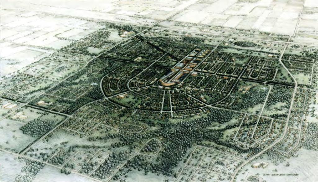
9 Streetscape and Public Realm Design Standards 2.4 Areas of Prominence The Town of East Gwillimbury also identifies areas of prominence within the community that should include unique streetscape and public realm design features and assets specific to individual community areas. Examples Yonge and Green Lane Regional Corridors Leslie Street in Sharon at Civic Square or Civic Centre Precinct Downtown/Village Core Mount Albert Downtown/Village Core Holland Landing Entry to Queensville Centre These areas and others are identified individually in the policies of the Official Plan Staff as Centres and Corridors in Section As is suggested by Official Plan Section 3 - Community Building and further elaborated in the policies of Section 4 - Land Use Policies, it is recommended that these areas be subject of separately submitted detail streetscape design and urban design studies to ensure the theme of the community is preserved within the designs for areas of prominence. An example of this type of conceptual design from which detail design can based is contained in the Official Plan as Appendix 3 Leslie Street Design Concepts

10 Streetscape and Public Realm Design Standards 3.0 Town-wide Design 3.1 Streetscape Design Themes In general terms, block structure and road network hierarchy creates a variety of streetscape conditions responsive to the nature of adjoining land uses and roadway classifications. Well-coordinated streetscape design produces consistent themes and unifying appearance for the areas of the community. Streetscape concepts for distinct and identified, individual community areas will build upon this underlying structure and emphasize character and theme: be that of the rural aesthetic of traditional small-town Ontario settings; historical heritage districts, contemporary and modern communities; or the commercial, mixed-use corridors and centres highlighted in the Official Plan. All streetscape design is expected to provide a safe and clear opportunity for a full range of alternative modes of transportation and a consistent, high quality and universally accessible pedestrian environment for the public realm. Design elements including: landscaped medians and boulevards; decorative fence and railing designs; walls, planters, features and edges of stone, concrete and masonry; street architecture and furniture; shade structures and shelters; and special vehicular or pedestrian paving treatments, are to combine with traditional street tree arrangements to define the street and to emphasize gateways and areas of special interest at critical points within the streetscape. For individual community development areas, the mandated and separate, area-specific Architectural Control and Urban Design Guidelines will coordinate with the Town s streetscape design themes to emphasize important vistas, intersections and street corners throughout the general area of plans and the identified Centres within the subject district. This will lend distinction to important and special places within the community and help to articulate the discernable community structure encouraged by the Official Plan. These themes, materials and elements may also be carried through to the design of the local parklands, trails and open spaces to support the community design vision. The following recommendations are suggested to help guide the development of streetscapes coordinated with development: 3.2 Arterial Roads of Regional and Local Corridors The following guidelines and objectives are to be considered in streetscape designs: The recognized prominent and special areas of Regional Corridors and Centres should be subject to separate and individual public streetscape and urban design studies approved by East Gwillimbury Council. Such studies should provide special details of streetscape features and elements. Design is to recognize the defined Community and Town Gateways highlighted in the Official Plan. Certain corridors within recognized community areas should also coordinate the establishment of more locally based gateways into distinct development areas. Gateways should be developed with consistent materials and themes to reinforce the general streetscape concepts for the area
11 Streetscape and Public Realm Design Standards Provide emphasis at gateways and landmarks through opportunities for highly developed planted centre medians, landscape buffers and corner gathering areas with decorative pavements, distinctive street furniture, site architecture, signage, and public art. The features of Gateways and their details shall be visible and of sufficient scale to be identifiable and appreciated at the design speeds of the regional arterial roads. Gateway features should be designed as complementary design elements without obstructing important views to the architecture of neighbouring development. Materials for gateway features shall be consistent with the overall themes of the community while also being resistant to the high salt environment of the arterial roads. Arterial commercial frontages should be developed with generous on-site landscape buffer blocks to ensure effective screening of parking and service areas. This site plan based landscape development should be closely coordinated with the public realm streetscape of the regional and local roads. Planting design shall establish adequate tree lawn areas with sufficient depths of planting medium, consistent along block lengths of a corridor. Tree-lawns are to provide a substantial landscape treatment coordinated with adjoining site landscape buffer development to create the Green Corridor effect highlighted in the Official Plan. Planting design should be structured with plant materials that are in scale with the large expanses of space between the street-walls of arterial corridors. Planting schemes should utilize varieties with high salt and exposure tolerances. Designs are encouraged to include species with high contrast in colours and textures to reinforce the landmark nature of Centres and Gateways. Arterial classes of road shall integrate the requirement and facilities of local and regional transit as a clear component of streetscape design. Corridor streetscape design will facilitate the goals of the ATTMP through the provision of on-road and boulevard bicycle routes connected with mass transit and integrated with the Cycling Network of East Gwillimbury and the Region of York Trail System. Trails and paths will be complete with clear signage and discernable paving features to establish a visible and understandable transportation function within the right-of-way. Arterial streetscapes shall provide a safe pedestrian environment through the design of a clear path of travel: unobstructed and clearly accessible sidewalks; clear, detectible and visible pedestrian crossing points at traffic controlled locations with opportunities for ample pedestrian refuge within the crossing. Pedestrian movement within the streetscape shall provide opportunities for social gathering, resting and in particular provide those with mobility assistance devices to have social spaces, places that afford side by side travel, and the full opportunity participate in the experiences and social activities of the streetscape. Arterial road streetscapes are to feature disciplined locations of utility corridors and plant. Municipal staff should ensure close coordination with Regional Road Design Staff and both the Town and Region should ensure communication and coordination with outside utility companies to maintain efficiency and discipline in the design of the features of the right-of-way. Utilities should be integrated to afford logical designs for pedestrian and bicycle clear-ways and to maximize the opportunities for street tree planting of large crowned shade trees in scale with the magnitude of the corridor

12 Streetscape and Public Realm Design Standards The Green Lane Corridor The Regional Corridor of Green Lane will be the first area of community streetscape encountered by residents and visitors arriving in East Gwillimbury from the south. Green Lane will be a defining element of the southern edge of the municipality and presents the first opportunity to communicate the Town s intent for high quality public realm to those arriving from the major access points of Highway 404 and Yonge Street. The Official Plan in the preamble of Section anticipates the importance of this Regional Corridor and the Centres that will be defined by points of access and public transportation infrastructure: Centres and Corridors contribute to an urban structure where major streets, community cores, and intersections become focal points for activity and built form in the community. They will be planned to accommodate the highest densities and broadest mix of uses in the Town. It is intended that Centres and Corridors will provide for the majority of medium and high density housing and become a focal point for residents to meet weekly needs such as employment, education, community level recreation and parks, human services, entertainment, shopping, personal services and worship Similar to other major land use corridors in the Region such as Highway 7 in Markham or Yonge Street in Richmond Hill and Thornhill, Green Lane should be subject to individual streetscape detail design exercises and special detailing for the elements of the public realm. Green Lane is identified as the prime location for high order land use and contemporary streetscape style with complete and inclusive designs. As a part of the identified Secondary Plan Study Areas B4 and B5; and the requirements for Complete Applications under Official Plan Section 8 Implementation; the Green Lane Corridor will be subject to individual studies of Urban Design to assure conformance to Secondary Plan requirements. As an integral part of development approvals it is recommended that detail design study of the Green Lane Streetscape be undertaken as a Town-initiated, public design process in cooperation with East Gwillimbury Community Interest Groups, Departments of the Region of York, Utility Providers, Stakeholder Landowners, Provincial Approval Agencies, The Town of Newmarket and the General Public. This design exercise should provide a level of excellence and public realm appearance equal to the recent regional corridor improvement projects previously mentioned. It is to have the goal of creating a defined appearance for the corridor; its intersections, connections and gateway areas commensurate with the importance of Green Lane within the municipality and the Region. A full array of materials, features and details should be reviewed and confirmed to provide the coordinated, clear vision that completely responds to the high expectations of the community and meets the stated goals for the Corridors and Centres of East Gwillimbury as expressed in the Official Plan


13 Streetscape and Public Realm Design Standards As has been previously noted in the discussion of guidelines, these designs need to provide for the coordination of the component functional parts of the arterial road corridor. Private and public vehicular transportation needs, including bicycle systems; pedestrian movement, comfort and safety; a high quality appearance and performance of materials are to combine in a well-organized and functional streetscape. The absence of this level of design coordination resulted in the challenges and obstacles already encountered for the implementation of streetscape within the western limits of Green Lane: and this is a reminder of the importance of comprehensive and inclusive design to the success of achieving the goals of the community Leslie Street at Sharon Village Core The Official Plan in Appendix 3 provides an example of preliminary streetscape design for the Leslie Street corridor in the area that is planned to become the Civic Square precinct. The centre of Sharon provides one of the primary focal areas of historical, cultural and social heritage for the municipality. The corridor to the south of Mount Albert Road East to Arthur Hall Drive contains some of the characteristic elements of more rustic and rural Ontario village core areas. Residential properties with a collection of architectural styles (some adapted for non-residential uses) are mixed with occasional commercial uses, and the formality of the Sharon Temple National Historical Site and other traditional, institutional architecture of places of worship, a local school, and the more modern style of the East Gwillimbury municipal offices. These built forms, some of which are at the street-line and some set back at various distances, create the street wall of the corridor accented with


14 Streetscape and Public Realm Design Standards front yard landscapes and the mature and very large traditional varieties of trees at the edges of front yard areas. Intermingled with the tree canopy are overhead service lines and utility poles carrying a variety of utilitarian, cobra-head street lamps and pole-mounted hydro transformers. The travelled road is edged with single-stage concrete gutters with paved shoulders that accommodate informal parking areas along with unstructured space for cyclists. Narrow sidewalks are provided through much of the frontage of both sides of the street. Though the streetscape provides for the necessities of street life it would benefit from an upgrade of appearance and character and from the definition of function for the various components of the regional road as development proceeds around the Sharon community and pressures on the function of the roadway increase the need for change. While Leslie Street in the area is outdated, out of step with its history, and somewhat disorganized, it is not an overly uncomfortable place to be nor dramatically unsightly. It doesn t however convey the importance of the cultural and social role that it plays in the East Gwillimbury community nor displays the aesthetic qualities to suit the very significant heritage of the local district. As growth proceeds and new residents arrive the reinforcement of this role through the quality of the streetscape environment will become increasingly important

15 Streetscape and Public Realm Design Standards The conceptual designs illustrated in Appendix 3 seek to unify the elements of the streetscape, introduce a more consistent level of quality to the paved surfaces and street features while providing greater capacity for organized vehicular and pedestrian movement. Section of the Official Plan provides criteria for the development of Village Core areas: i) Traditional mainstreet areas shall be revitalized and preserved to reinforce the character of the mainstreet; ii) Cultural heritage resources shall be conserved and where possible, enhanced; iii) Transit facilities should be easily accessible to pedestrians; iv) The surrounding areas should relate to and be efficiently connected with Village Core Areas through the integration of bicycle and pedestrian trail systems; v) All utilities shall be provided underground, where feasible. It is recommended that the corridor be subject of a detail design study to finalize details of streetscape in context with the development of designs for the Civic Square Precinct. This will provide definitive details and material selections for the block lengths to the north and south of Mount Albert Road. This design process should also facilitate the cycling network on the Regional Road as is required by the Official Plan and the ATTMP but is not currently shown in the streetscape concepts. As growth in the Sharon area is well underway the finalizing of design approach to the Leslie Street streetscape in the Sharon Village Core should be a short-term priority for the Town Queensville Centre The vision for Queensville Centre has been long established with the distinctive radial design of the district road network and block structure established in the late 1980 s. The new growth area will feature a community core of a broad mix of commercial, higher density residential and mixed-use developments along the length of the regional arterial and a focal area of development at the mid-block of Leslie Street. This corridor area extending between Queensville Sideroad and Doane Road is to feature Major Gateway areas to frame the north and south entrances to the district at these major east/west regional arterial roads. To the north this will build upon the traditional four-corners of Queensville to strengthen the area as a Gateway, complete with well

16 Streetscape and Public Realm Design Standards developed public realm streetscapes and landmark areas. To the south, development proposals and their associated interface with the public realm are to combine to create a definitive Gateway at the southern edge of the district. The Leslie Street core of Queensville is planned for development of major public buildings and institutions mixed with the permitted mixture of higher density residential and commercial built forms brought to the street edge as the focus for the local community. It is recommended that the existing Urban Design and Architectural Control guideline documents form the initial basis for the examination of streetscape design for the Leslie Street Corridor in Queensville. A specific design process should be conducted for the vision and details of the corridor working with the stakeholders and the development partners for the area. A contemporary and modern tone is suggested for the detailing of the streetscape for the area and the Leslie Street Corridor should include exclusive details representative of the district theme. The establishment of the Queensville Centre complete with comprehensive streetscape design combined with the initiatives for Sharon and the Civic Square will result in an extremely rewarding and diverse experience of streetscape along the length of Leslie Street as residents and visitors travel north from Green Lane through the heart of the two distinct communities Mount Albert Village Core The visioning of the Mount Albert Village Core has already been initiated by the Town. Building upon the policies in Section 8 Implementation of the Official Plan, the Mount Albert Downtown Revitalization Strategy and Community Improvement Plan. This plan examines a full range of urban design and streetscape opportunities for the Village Core of Mount Albert. The open public process of the plan reveals public opinion that streetscape was one of the largest priorities for the community. The Plan recognizes the distinct and separate nature of Mount Albert given the geography of the area within the municipality and the strength of identity and history possessed by the area. It recognizes that the defined location and identifiable edges foster this strong and


17 Streetscape and Public Realm Design Standards independent sense of community. In light of this and the established core of the village, the Plan examines the design principles for the Public Realm and provides guidance for its future development. The following are excerpts from the Plan document providing guiding direction for the design of the public realm and streetscape for the Village Core. The Plan recommends the following primary action items to provide a foundation for the enhancement of Mount Albert: The Plan further details the potential of enhancing the public realm as a critical component of an overall strategy of fostering improvement and preservation of the role of the downtown within the Mount Albert District:


18 Streetscape and Public Realm Design Standards The Plan suggests specific improvements for the streetscape of the Mount Albert Downtown and illustrates how details may be articulated: with the guiding recommendations of Improvement Plan offering structure to the proposals. The Plan further articulates these recommendations in further detail and in site-specific fashion through the Implementation sections of the document. The Mount Albert Downtown Revitalization Strategy and Community Improvement Plan provides a strong basis for the development of detail design throughout the balance of the district. Building upon this public consensus for design the streetscape of the local areas and prominent edges can be developed and the general suggestions for design elements suggested by this document applied


19 Streetscape and Public Realm Design Standards Holland Landing Village Core Similar to Mount Albert, Holland Landing together with River Drive Park is recognized for its separate identity within East Gwillimbury resulting from its geography and historical settlement along the Holland River Valley. Along with the buildings that framed the original Yonge Street, the local history of the plans for the Holland channel and riverine lock system to support commercial trade speak what has become the identity of the area and its sense of place. The more recent and proposed growth for the area is guided by Official Plan policy (and OPA #60 as amended). Urban Design and Architectural Control documents have been created to help guide this pattern of development for two main areas of residential growth and speak to the design of the public realm and the enhancement of the historical identity of the area. These documents discuss and make recommendation in part based upon the cultural and architectural heritage of the area and on the strength of the natural open spaces of the Holland River corridor. Further to the general directions included in these design control documents, the Town seeks to strengthen the identity of the Village Core of Holland Landing through the policies of the Official Plan. It is recommended that a similar study to that being performed for Mount Albert be conducted for the core areas of Holland Landing to define the nature of the Village Core in light of the impending development around its edges. This study would further strengthen the public vision for the areas and underwrite the goals of the independent design studies completed for development in the area: increasing the potential for success in maintaining and enhancing the character of the Village Core area

20 Streetscape and Public Realm Design Standards 3.3 Local Road Hierarchy The Official Plan provides a description of road hierarchy and policies for road design and construction in Section 7 Sustainable Infrastructure. The following is a portion of the Table 7.1 which sets out the role and parameters local road hierarchy: Major Collector Roads The system of major collector roads within the individual settlement areas of the municipality reinforce the structure of the community and provide for connectivity between sub-neighbourhood areas within secondary plans. Similar to the role of the more major corridors these spine roads within the block structure of development are to convey the clear themes established for the communities of East Gwillimbury. Their larger size provides for the inclusion of special detailing and opportunities to create significant and recognizable areas within the public realm. The district role as connectors to the broader transportation networks of the town means that Major Collector Roads will be travelled more frequently and by greater numbers of residents and visitors to the area. While the more local road components of the road hierarchy might utilize the Town s more standard, harmonized details for the public realm, it is highly recommended that the Town encourage the use of the suggested trademark theme details of the individual communities within the public realm of these important, structuring roads. This should be encouraged as a clear design goal for urban design and streetscape proposals submitted in support of development plans. The following streetscape characteristics should be considered for the Major Collector Roads: Major Collector streetscapes should be developed with similar emphasis of design to those of the Regional and Local Corridors though they should be reflective of the reduced scale of adjoining development and infrastructure. Gateways, edges and landmarks are to be identifiable and defining features of the area with streetscapes presenting clear pedestrian, accessibility and transit qualities and a communication of the role of the corridor in the hierarchy of the local district
21 Streetscape and Public Realm Design Standards Streetscape elements of Major Collector Roads should be coordinated with Architectural features and adjoining site plan development features through the municipal development control mechanisms to ensure consistency throughout the plan area and a high quality presentation within the public realm. The Major Collector road should be developed to ensure a consistent tree lawn along the commercial frontages coordinated with the landscape development of the adjoining development parcels. Prominent intersections along the Major Collector Road systems should be responsive to and include area theme and functional elements such as: neighbourhood gateways and entry features; local landmark features or open vistas to significant landscapes; planted or paved median features; street signs tied to the community theme; bike boxes and defined bikeway elements; transit stops with special design detailing and Public Art. Roadway intersection pavements may include colour and detail to reinforce the visibility of neighbourhood gateways, local landmark features and the functions of pedestrian crossing. The approaches to intersections may have street trees planted on both sides of the sidewalk/bikeway within the areas of widened boulevard. Street furniture such as light poles, mailboxes, utility boxes, signs and transformer plant should be coordinated with the street tree planting and aligned with the tree planting to maintain a clean and organized streetscape. The desire for independent newspaper boxes, waste and recycling receptacles should be anticipated and provided for at designated convenient locations to reduce clutter in the streetscape. Street tree selections should be large crown deciduous varieties. Species selection should be limited to two or three varieties of (native trees where possible) to provide a consistency of appearance along the block length. Street tree selections should be salt tolerant, drought resistant varieties and should provide visual consistency along the block length with emphasis at site entrances. Where road frontages are integrated with heritage architecture or heritage districts, street trees should include varieties reflective of traditional landscapes in the area. The use of materials and design aesthetics for features and fencing should respond to the local setting of the surrounding community. Where Major Collector Roads transition to areas beyond the district, design should respond to the setting of natural features and the context for rural and village landscapes beyond the defined districts. Such areas should include aspects of the Town s harmonized standards as applicable for the area Local Collector Roads The following characteristics should be considered for the character of Local Collector Roads: Bump-outs or widened boulevards may be used to define intersection locations and areas of lay-by parking along the streetscape. Roadway intersection pavements may include colour and detail to reinforce the visibility and functions of pedestrian crossing. The approaches to intersections may have street trees planted on both sides of the sidewalk within the areas of widened boulevard

22 Streetscape and Public Realm Design Standards The collector road should be developed to ensure a consistent tree lawn along the streetscape. Street trees for any nonresidential frontages are to be coordinated with the landscape development of the adjoining development parcels. Street tree selections should be salt tolerant, drought resistant varieties and should provide visual consistency along the block length with emphasis at site entrances. Ornamental, flowering trees may be used to emphasize intersection locations and sub-neighbourhood entrances. Privacy screen fences shall not obscure the architectural details of the side elevations of corner lot dwellings. Street features such as lighting and signage should have a coordinated style and appearance tied to the harmonized standards of East Gwillimbury or to the broader themes of the community area. Street furniture including light poles, mailboxes, utility boxes, signs and transformer plant should be coordinated with the street tree planting and aligned to maintain a clean and organized streetscape. Street tree selections should be large crown deciduous varieties wherever possible to maximize the contribution to the urban canopy. Species selection should be made in response to the adjoining scale of development and should limited to two or three varieties (native trees where possible) to provide a consistency of appearance along a block length area. Tree groupings should not exceed ten specimens within a group to ensure diversity and disease resistance in the streetscape canopy. Street furniture such as light poles, mailboxes, utility boxes, signs and transformer plant should be coordinated with the street tree planting and aligned with the tree planting to maintain a clean and organized streetscape Local Roads At a minimum the Town of East Gwillimbury Standard details for streetscape elements are to be applied throughout the local road systems of new developments. Local streets will often feature coordinated side yard fencing in combination with Architectural Control for priority lots at corners, vistas and t-intersections. The cross-sections for local streets will have a tree lawn established in the boulevard, free from encumbrances as suggested in the road cross-sections illustrated in this document. The area for street trees should be maximized by close attention to utility coordination for the streetscape and through appropriate driveway spacing and pairing of driveways along the frontages. Street tree

23 Streetscape and Public Realm Design Standards varieties should be selected to compliment the importance of vistas and intersection areas noted in Architectural Control documents. Native species should be used wherever possible and each block length should display a mixture of species to ensure variety and avoid monoculture planting. The following characteristics should be considered for the local road network: Side-yard flankage areas will include consistent designs for privacy fencing to ensure the coordination of themes visible in the public realm. The street frontage of parks should be developed with unique qualities that respond to the visual assets of these areas. Park frontage streetscapes should be designed in coordination with the detail design of the neighbouring park facilities. Trail connections and park entrances should be treated as landmark locations and considered by the municipality for the construction of community features to strengthen this role. Street trees throughout the district areas should have a high percentage of native species and exhibit a judicious use of exotic varieties. Planting at the edges of natural heritage open space are to be composed entirely of native and non-invasive species of street tree. Traditional varieties should be employed to reinforce and support historical, heritage landscapes. Where salt tolerance is a governing factor for the streetscape planting (as is the case on the arterial roads) the use of some non-native varieties may be essential to ensure survivability of the landscape features. General streetscapes throughout the residential neighbourhoods should include a consistent planting of street trees coordinated with utility plant and road geometry. Street tree planting should be used to emphasize vistas and intersections. The municipality should promote the use of native trees and the planting of a variety of different species for each street and neighbourhood area. Street tree selections for each street should be medium to large crown deciduous varieties. Species selection should be limited to two or three varieties of native trees on each street to provide a consistent appearance along the block length. Special locations along local streets such as window streets should include distinctive street tree varieties coordinated with park landscape frontage and the collector roads beyond

24 Streetscape and Public Realm Design Standards Evergreen trees may be used for emphasis at window street locations and to screen car headlights from the collector road and fronting residences. Window streets may include decorative fencing, street furniture and special spaces such as transit stops. Details of these are to be coordinated with the themes and materials of community features. Ornamental, flowering trees should be used to emphasize intersection locations and the neighbourhood gateway. Street furniture such as lighting, signage should have a coordinated style and appearance tied to the broader themes of the planning area. Street furniture such as light poles, mailboxes, utility boxes, signs and transformer plant should be coordinated with the street tree planting and aligned with the tree planting to maintain a clean and organized streetscape


25 4.1 General Standards


 U.S.I. CP325BSOBE Arm: Aluminous:NSB-6")


 6 x 12 (37%)")
26 General Standards Site Furnishings Palette Bike Rack Lighting Bench Bollard Size: Varies Material: HS Steel Tube Finish: Powdercoat- in matte black Manufacturer: Maglin Litter Luminaire: Cooper;SDL B03 LED E SL2 BKU To Match P IES King: K601 S Pfafl III 75 SSL To Match CE812P.IES Philips-Lumec; L40U 55W32LED 4KES ACDR CR LE2; To Match L40u-55W 32LED4k-R-LE2.IES Pole: Stresscrete: E-325- BPO-G-S11-FC (BLK) U.S.I. CP325BSOBE Arm: Aluminous:NSB-6 Cooper:SCA6001BK Paving Standard Length: 1778mm Materials: solid steel flat bar & HS steel tube Finish: powdercoat Options: centre arm plaques Manufacturer: Maglin Size: 900mm height Material: Steel Pipe Finish: Hot Dipped Galvanized, finish with primer & 2 coats of semi gloss epoxy black enamel Manufacturer: Maglin Size: 34 Gallon Materials: frame- Heavy Duty Steel Bar Liner; Commercial Grade Plastic Liner Lid: Black Molded Plastic Finish: Powdercoat-matte finish in black Colour: Plastic; Black Manufacturer: Maglin Product: Series 3000 Manufacturer: Unilock or equivalent Colour: Crystal Rose Size: 30 cm x 15 cm x 7 cm & 30 cm x 30 cm x 7 cm Pattern: D 12 x 12 (54%) 6 x 12 (37%) 6 x 6 (9%) Jointing Compound: Black Sand Maintenance: Semi-annual cleaning of joints


27 Property Line Street Line 1.5m SIDE WALK Street Line Min 4m setback Smaller canopy tree adjacent to street light Hydrant Setback 1.50m Typ. Street tree planting adjacent to frontyard landscape areas to maximize potential root zone Street Light to area theme as per conventional spacing Transformer Scale: NTS 18.0m RIGHT OF WAY LOCAL ROAD-Plan DETAIL # EG-Q-001


28 Street Line Street Tree Setback 1.50m Typ. Sidewalk Setback 1.50m Typ. CL Street Tree Setback 1.50m Typ. Street Line UTILITY UTILITY TRENCH TRENCH BUILDING SETBACK AS PER ZONING PRIVATE PROPERTY STREET TREE PLANTING ZONE / STREET FURNITURE / SOD BOULEVARD / 1.5m CONCRETE SIDEWALK SOD BOULEVARD TRAVEL LANE TRAVEL LANE STREET TREE PLANTING ZONE / STREET FURNITURE / SOD BOULEVARD / PRIVATE PROPERTY BUILDING SETBACK AS PER ZONING STREET TREES LOCATED TO PROVIDE MAXIMUM GROWTH AREA AND AVAILABLE TOPSOIL GROWTH MEDIUM FOR ROOT ZONE. TREE LOCATIONS SETBACK FROM STREET LIGHTING TO LIMIT CONFLICTS RECOMMENDED DEPTH 450mm 2.50m 18.00m R.O.W 3.00m STREET TREES LOCATED TO PROVIDE MAXIMUM GROWTH AREA AND AVAILABLE TOPSOIL GROWTH MEDIUM FOR ROOT ZONE. TREE LOCATIONS SETBACK FROM STREET LIGHTING TO LIMIT CONFLICTS RECOMMENDED DEPTH 450mm 18.0m RIGHT OF WAY LOCAL ROAD-Section Scale: NTS DETAIL # EG-002

29 Transformer Property Line Street Line 1.5m SIDE WALK Transformer Street Light Standard Street Line Min 4m setback Smaller canopy tree adjacent to street light Min 4m setback Smaller canopy tree adjacent to street light Hydrant Setback 1.50m Typ. Street tree planting adjacent to frontyard landscape areas to maximize potential root zone 1.5m SIDE WALK Setback 1.50m Typ. Street Light to area theme as per conventional spacing Scale: NTS 20.0m R.O.W RESIDENTIAL ROAD-Plan DETAIL # EG-003

30 Street Line Street Tree Setback 1.50m Typ. Sidewalk Setback Sidewalk Setback 1.50m Typ. 1.50m Typ. CL Street Tree Setback 1.50m Typ. Street Line UTILITY TRENCH UTILITY TRENCH BUILDING SETBACK AS PER ZONING STREET TREES LOCATED TO PROVIDE MAXIMUM GROWTH AREA AND AVAILABLE TOPSOIL GROWTH MEDIUM FOR ROOT ZONE. TREE LOCATIONS SETBACK FROM STREET LIGHTING TO LIMIT CONFLICTS RECOMMENDED DEPTH 450mm PRIVATE PROPERTY STREET TREE PLANTING ZONE / STREET FURNITURE / SOD BOULEVARD / 1.25m 1.5m CONCRETE SOD SIDEWALK BOULEVARD TRAVEL LANE 20.00m R.O.W TRAVEL LANE SOD BOULEVARD 1.5m CONCRETE SIDEWALK STREET TREE PLANTING ZONE / STREET FURNITURE / SOD BOULEVARD / 1.25m PRIVATE PROPERTY BUILDING SETBACK AS PER ZONING Scale: NTS 20.0m R.O.W RESIDENTIAL ROAD-Section DETAIL # EG-004
31 Property Line Street Line 1.5m SIDE WALK Transformer Street Light Standard Street Line Min 4m setback Smaller canopy tree adjacent to street light Min 4m setback Smaller canopy tree adjacent to street light Hydrant Sidewalk Setback 2.0m Typ. Street tree planting adjacent to frontyard landscape areas to maximize potential root zone 1.5m SIDE WALK Sidewalk Setback 2.00m Typ. Street Light to area theme as per conventional spacing Scale: NTS 22.0m R.O.W RESIDENTIAL ROAD-Plan DETAIL # EG-005

32 Street Line Street Tree Setback 2.00m Typ. Sidewalk Setback 1.50m Typ. CL Sidewalk Setback 1.50m Typ. Street Tree Setback 2.00m Typ. Street Line UTILITY TRENCH UTILITY TRENCH PRIVATE PROPERTY STREET TREE PLANTING ZONE / STREET FURNITURE / SOD BOULEVARD / 1.5m CONCRETE SOD SIDEWALK BOULEVARD TRAVEL LANE TRAVEL LANE 1.5m SOD CONCRETE BOULEVARD SIDEWALK STREET TREE PLANTING ZONE / STREET FURNITURE / SOD BOULEVARD / PRIVATE PROPERTY BUILDING SETBACK AS PER ZONING STREET TREES LOCATED TO PROVIDE MAXIMUM GROWTH AREA AND AVAILABLE TOPSOIL GROWTH MEDIUM FOR ROOT ZONE. TREE LOCATIONS SETBACK FROM STREET LIGHTING TO LIMIT CONFLICTS RECOMMENDED DEPTH 450mm 2.00m 22.00m R.O.W 2.00m BUILDING SETBACK AS PER ZONING STREET TREES LOCATED TO PROVIDE MAXIMUM GROWTH AREA AND AVAILABLE TOPSOIL GROWTH MEDIUM FOR ROOT ZONE. TREE LOCATIONS SETBACK FROM STREET LIGHTING TO LIMIT CONFLICTS RECOMMENDED DEPTH 450mm Scale: NTS 22.0m R.O.W RESIDENTIAL ROAD-Section DETAIL # EG-006

33 Street Line CL Street Line UTILITY TRENCH UTILITY TRENCH BUILDING SETBACK AS PER ZONING PRIVATE PROPERTY STREET TREE PLANTING ZONE / STREET FURNITURE / SOD BOULEVARD / 2.25m 1.5m CONCRETE SOD SIDEWALK BOULEVARD TRAVEL LANE 26.0m R.O.W PLANTED MEDIAN TREES/SHRUBS/ ORNAMENTAL GRASS / PAVED SHOULDER 4.0m Min. TRAVEL LANE STREET TREES LOCATED TO PROVIDE MAXIMUM GROWTH AREA AND AVAILABLE TOPSOIL GROWTH MEDIUM FOR ROOT ZONE. TREE LOCATIONS SETBACK FROM STREET LIGHTING TO LIMIT CONFLICTS RECOMMENDED DEPTH 450mm 1.5m SOD CONCRETE BOULEVARD SIDEWALK STREET TREE PLANTING ZONE / STREET FURNITURE / SOD BOULEVARD / 2.25m PRIVATE PROPERTY BUILDING SETBACK AS PER ZONING Scale: NTS Queensville 26.0m R.O.W COLLECTOR ROAD WITH MEDIAN-Section DETAIL # EG-Q-001
34 Property Line Hydrant Street Line 1.5m SIDE WALK Berm 1.5m SIDE WALK MEDIAN PLANTING Transformer Raised Median Planter Street Line CURB CUT/ ACCESSIBLE RAMP Street tree planting adjacent to frontyard landscape areas to maximize potential root zone TACTILE WALKING SURFACE INDICATORS ON SIGNALIZED INTERSECTIONS STAMPED ASPHALT CROSSWALK COLOUED CONCRETE MEDIAN PAVING STREET LIGHT STANDARD HAMLET THEME IMPRINT ON CONCRETE Scale: NTS 26.0m R.O.W COLLECTOR ROAD WITH MEDIAN-Plan DETAIL # EG-Q-007
35 Street Line Street Line UTILITY TRENCH UTILITY TRENCH PRIVATE PROPERTY STREET TREE PLANTING ZONE / STREET FURNITURE / SOD BOULEVARD / 1.5m CONCRETE SOD SIDEWALK BOULEVARD TRAVEL LANE TURNING LANE TRAVEL LANE SOD BOULEVARD 1.5m CONCRETE SIDEWALK STREET TREE PLANTING ZONE / STREET FURNITURE / SOD BOULEVARD / PRIVATE PROPERTY BUILDING SETBACK AS PER ZONING 2.00m 1.5m BIKE LANE 1.5m BIKE LANE 2.00m BUILDING SETBACK AS PER ZONING 26.00m R.O.W Scale: NTS 26.0m R.O.W COLLECTOR ROAD WITHOUT MEDIAN-Section DETAIL # EG-008
36 Hydrant Property Line Street Line 1.5m SIDE WALK Street tree planting adjacent to frontyard landscape areas to maximize potential root zone Transformer 1.5m SIDE WALK Street Line CURB CUT/ ACCESSIBLE RAMP TACTILE WALKING SURFACE INDICATORS ON SIGNALIZED INTERSECTIONS STAMPED ASPHALT CROSSWALK STREET LIGHT STANDARD HAMLET THEME IMPRINT ON CONCRETE Scale: NTS 26.0m R.O.W COLLECTOR ROAD WITHOUT MEDIAN-Plan DETAIL # EG-007


37 Trach Can Bike Rack Coloured Concrete Paving Unit Paving Bench 2.0m BIKE TRAIL 2.0m BIKE TRAIL 2.0m SIDE WALK Hamlet theme imprint CURB CUT/ ACCESSIBLE RAMP Street Line Street Light Standard 10m X 4.5m CONCRETE BUS PAD 2.0m SIDE WALK mm KILLSTRIP STAMPED COLOUR CONCRETE Street Light Standard 2000mm ASPHALT BIKE TRAIL Transformer 2.0m CONC. SIDEWALK Street Line NOTE: STAMPED COLOUR CONCRETE KILLSRIP AND MEDIAN APRON COLOUR AND PATTERN TO CORRESPOND TO THEME OF EACH DISTRICTS 200mm HIGH CONCRETE CURB 1.0m KILLSTRIP STAMPED COLOUR CONCRETE 350mm WIDE MEDIAN APRON, STAMPED COLOUR CONCRETE 350 TYP. COLOURED CONCRETE MEDIAN PAVING ASPHALT CROSSWALK BANDING PER REGION OF YORK STANDARDS TACTILE WALKING SURFACE INDICATORS ON SIGNALIZED INTERSECTIONS HAMLET THEME IMPRINT ON CONCRETE 36.0m R.O.W REGIONAL ROAD WITH MEDIAN-Plan (Bike Lane on Boulevard) Scale: NTS DETAIL # EG-Q-001

38 CL Street Line Street Line PRIVATE PROPERTY BUILDING SETBACK AS PER ZONING STREET TREE PLANTING ZONE / BUS SHELTER / STREET FURNITURE/ SOD BOULEVARD/ LANDSCAPE STRIP 3.00m 3.75m 4.50m 2.0m CONCRETE SIDEWALK 2.0m BIKE LANE 0.5m KILLSTRIP 500mm KILLSTRIP TRAVEL LANE TRAVEL LANE PLANTED MEDIAN 36.00m TURNING LANE TRAVEL LANE 500mm KILLSTRIP 0.5m KILLSTRIP 2.0m BIKE LANE 2.0m CONCRETE SIDEWALK STREET TREE PLANTING ZONE / BUS SHELTER / STREET FURNITURE/ SOD BOULEVARD/ LANDSCAPE STRIP 3.00m 3.75m 4.50m PRIVATE PROPERTY BUILDING SETBACK AS PER ZONING 36.0m R.O.W REGIONAL ROAD WITH MEDIAN-Section (Bike Lane on Boulevard) Scale: NTS DETAIL # EG-Q-001

39 Trach Can Bike Rack Coloured Concrete Paving Unit Paving Bench Hamlet theme imprint Street Line m X 4.5m CONCRETE TRANSIT PAD m SIDE WALK BIKE LANE Street tree planting adjacent to frontyard landscape areas to maximize potential root zone Transformer Street Light Standard BIKE LANE 2.0m SIDE WALK Street Line Street Light Standard 1.0m KILLSTRIP STAMPED COLOUR CONCERTE 200mm HIGH CONCRETE CURB CURB CUT/ ACCESSIBLE RAMP 1m WIDE KILLSTRIP STAMPED CONCRETE PAVING STREET CORNER PLANTING BED AT PRIMARY STREET INTERSECTIONS SPECIFY SALT TOLERANT SPECIES NOTE: STAMPED COLOUR CONCRETE KILLSRIP AND MEDIAN APRON COLOUR AND PATTERN TO CORRESPOND TO THEME OF EACH DISTRICTS STAMPED ASPHALT CROSSWALK TACTILE WALKING SURFACE INDICATORS ON SIGNALIZED INTERSECTIONS BIKE REFUGE AREA HAMLET THEME IMPRINT ON CONCRETE 36.0m R.O.W REGIONAL ROAD WITHOUT MEDIAN-Plan (Bike Lane on Roadway) Scale: NTS DETAIL # EG-009

40 Street Line Street Line UTILITY TRENCH 2.0m SIDEWALK UTILITY TRENCH PRIVATE PROPERTY BUILDING SETBACK AS PER ZONING STREET TREE PLANTING ZONE / BUS SHELTER / STREET FURNITURE/ SOD BOULEVARD/ LANDSCAPE STRIP 3.00m 2.0m CONCRETE 1.0m SIDEWALK KILLSTRIP 1.5m BIKE LANE TRAVEL LANE TRAVEL LANE TURNING LANE 36.00m R.O.W TRAVEL LANE TRAVEL LANE 1.5m BIKE LANE 1.0m KILLSTRIP 2.0m CONCRETE SIDEWALK STREET TREE PLANTING ZONE / BUS SHELTER / STREET FURNITURE/ SOD BOULEVARD/ LANDSCAPE STRIP 4.50m 3.00m 3.75m PRIVATE PROPERTY BUILDING SETBACK AS PER ZONING 36.0m R.O.W REGIONAL ROAD WITHOUT MEDIAN-Section (Bike Lane on Roadway) Scale: NTS DETAIL # EG-010
41 PROPERTY LINE Min 4m setback Smaller canopy tree adjacent to street light RESIDENTIAL DRIVEWAY STREET TREE LOCATED BETWEEN SIDEWALK AND STREET LINE TO TO PROVIDE MAXIMUM GROWTH AREA AND AVAILABLE TIOPSOILGROWTH MEDIUM FOR ROOT ZONE. TREE LOCATIONS SET BACK FROM STREET LIGHTING TO MINIMIZE CONFLICT 1.5m WIDE SIDEWALK Setback 1.50m Typ. CURB & GUTTER 1.00 STREET LIGHT HYDRANT SOD BOULEVARD Scale: NTS TYPICAL LOCAL STREET PLAN DETAIL # EG---
42 SOD BOULEVARD HAMLET THEME IMPRINT ON CONCRETE TACTINE WOLKING SURFACE INDICATORS ON SIGNALIZED INTERSECTIONS TO REGION OF YORK STANDARDS STREET LINE 2.00 m SETBACK STREET TREE LOCATED BETWEEN SIDEWALK AND STREET LINE TO TO PROVIDE MAXIMUM GROWTH AREA AND AVAILABLE TIOPSOILGROWTH MEDIUM FOR ROOT ZONE. TREE LOCATIONS SET BACK FROM STREET LIGHTING TO MINIMIZE CONFLICT HYDRANT 1.50 m SIDEWALK 1.25 m SOD BOULEVARD ASPHALT CROSS WALK TO REGION OF YORK STANDARDS BIKE LANE: STREETBOND CL COLOUR- EVERGREEN STREET LIGHT CURB & GUTTER 1.50 m BIKE LANE Scale: NTS TYPICAL SECONDARY STREET PLAN DETAIL # EG---

43 SOD BOULEVARD HAMLET THEME IMPRINT ON CONCRETE TACTINE WOLKING SURFACE INDICATORS ON SIGNALIZED INTERSECTIONS TO REGION OF YORK STANDARDS STREET LINE 2.00 m SETBACK STREET TREE LOCATED BETWEEN SIDEWALK AND STREET LINE TO TO PROVIDE MAXIMUM GROWTH AREA AND AVAILABLE TIOPSOILGROWTH MEDIUM FOR ROOT ZONE. TREE LOCATIONS SET BACK FROM STREET LIGHTING TO MINIMIZE CONFLICT HYDRANT 1.50 m SIDEWALK 1.25 m SOD BOULEVARD ASPHALT CROSS WALK TO REGION OF YORK STANDARDS BIKE LANE: STREETBOND CL COLOUR- EVERGREEN STREET LIGHT CURB & GUTTER 1.50 m BIKE LANE Scale: NTS TYPICAL SECONDARY STREET PLAN DETAIL # EG---

44 STAMPED ASPHALT CROSSWALK: 1m BANDINGS OF TREFFIC PATTERNS XD COLOURS; FIELD GREY & WHITE TACTINE WOLKING SURFACE INDICATORS ON SIGNALIZED INTERSECTIONS TO REGION OF YORK STANDARDS CURB CUT & HANDICAP RAMP TO AODA STANDARDS CONCRETE CURB & GUTTER BIKE REGUGE AREA- STREETBOND CL COLOUR- EVERGREEN STREET LINE SOD BOULEVARD BIKE LANE: STREETBOND CL COLOUR- EVERGREEN 1.0M WIDE COLOUR CONCRETE KILLSTRIP PER HAMLET THEME HAMLET THEME IMPRINT ON CONCRETE STREET LIGHT TRANSFORMER SOD BOULEVARD CURB & GUTTER 1m WIDE COLOUR CONCRETE KILLSTRIP PER HAMLET THEME STREET TREE LOCATED BETWEEN SIDEWALK AND STREET LINE TO TO PROVIDE MAXIMUM GROWTH AREA AND AVAILABLE TIOPSOILGROWTH MEDIUM FOR ROOT ZONE. TREE LOCATIONS SET BACK FROM STREET LIGHTING TO MINIMIZE CONFLICT Scale: NTS TYPICAL PRIMARY STREET PLAN (2) DETAIL # EG---

45 COLOURED CONCRETE MEDIAN PAVING BIKE LANE - COLOURED ASPHALT PAVING BY STREET BOND CL COLOUR- EVERGREEN TACTILE WALKING SURFACE INDICATORS PER REGION OF YORK SPECIFICATIONS AT ALL SIGNALIZED PRIMARY INTERSECTIONS CURB CUT & ACCESSIBLE RAMP PER 'AODA' STANDARDS 350 TYP. KILL STRIP PAVING (COLOUR CONCRETE /UNIT PAVING) PER HAMLET PAVING THEME COLOUR CONCRETE /UNIT PAVING MEDIAN APRON PER HAMLET PAVING THEME HAMLET THEME IMPRINT ON CONCRETE STREET CORNER PLANTING 2M STRIP PLANTING ADJACENT TO SIDEWALK- SPECIFY SALT TOLERANT PLANTING ASPHALT PEDESTRIAN CROSSING COLOUR AND PATTERN PER REGION OF YORK 'MAJOR INTERSECTION ROADWAY' SPECIFICATIONS Primary Street Corner Detail Plan (Bike Lane on Boulevard) Scale: NTS DETAIL # EG---
46 PRIVATE PROPERTY Street Line AS NOTED ON R.O.W SECTIONS AS NOTED ON R.O.W SECTIONS 450 MM DEPTH TOPSOIL JOINT UTILITY TRENCH USE 'BIOSHIELDS' TO DEFLECT TREE ROOT FROM UNDERGROUND UTILITIES WHERE SPACE IS CONSTRAINED STREET TREES LOCATED TO PROVIDE MAXIMUM GROWTH AREA AND AVAILABLE TOPSOIL GROWTH MEDIUM FOR ROOT ZONE. TREE LOCATIONS SET BACK FROM STREET LIGHTING TO LIMIT CONFLICTS STREET TREE 1.5m CONCRETE SIDEWALK Scale: NTS BOULEVARD TREE PLANTING DETAIL # EG----


 UNIT PAVER APRON PER HAMLET PAVING THEME 200x200mm OR 200x150mm PAVERS SHRUB / GRASS PLANTING CONCRETE PLANTER WALL (")

47 ELEVATION CONCRETE PLANTER WALL (EXPANSION JOINT EVERY 5m MAX.) HAMLET THEME IMPRESSION 2.0 TO 3.0m O.C ALONG WALL SUGGESTED DIMENSION 300x300mm C.I.P CONCRETE CRUB AND NOTES: 1. TREES AND SHRUBS PLANTED TO PARKS, RECREATION AND CULTURE STANDARDS. 2. SUB SURFACE DRAINAGE REQUIRED FOR ALL MEDIAN PLANTERS 3. PROVIDE IRRIGATION AND ELECTRICAL FEED. STREET TREE UNIT PAVING BANDING PER HAMLET PAVING THEME 200x200mm OR 200x150mm PAVERS 450m SLOPED TO DRAIN THROUGH GAPS BETWEEN FIBRE BITUMINOUS BOARDS PVC PERFORATED WATERING /AERATION INLET AND PIPE C.I.P CONCRETE CRUB AND GUTTER AS SPECIFIED 450m mm Ø PERFORATED PVC SUB DRAIN C/W GEOTEXTILE SOCK CONNECTED TO NEAREST CB SHRUB / GRASS PLANTING BACKFILL PLANTING SOIL COMPACTED TO MINIMIZE ROOTBALL SETTLING PLANTING SOIL MIX AS SPECIFIED GEOCOMPOSITE LINER CONCRETE PLANTER WALL (EXPANSION JOINT EVERY 5m MAX.) UNIT PAVER APRON PER HAMLET PAVING THEME 200x200mm OR 200x150mm PAVERS SHRUB / GRASS PLANTING CONCRETE PLANTER WALL ( EXPANSION JOINT EVERY 5m MAX. DROP CURB/ HC RAMP TACTILE WALKING SURFACE INDICATORS ON SIGNALIZED INTERSECTIONS HAMLET THEME IMPRINT ON CONCRETE COLOUR CONCRETE PAVING INTEGRAL COLOUR- COLOUR TO BE AS PER HAMLET THEME MIN. 4000mm OR AS PER APPROVED MEDIAN WIDTH VARIES m Min 3000 or as per approved median width FIBRE BITUMINOUS BOARD CONCRETE CURB PER ENGINEERING STANDARDS 200m 650 PLANTER CURB SECTION HAMLET THEME COLOUR CONCRETE /UNIT PAVING MEDIAN APRON PLAN Scale: NTS MEDIAN DETAIL DETAIL # EG---
48 BIKE RACK PER HAMLET THEME TRASH CAN PER HAMLET THEME ; MAJOR INTERSECTIONS TO RECEIVE COMPLETE RECYCLE STATIONS HAMLET THEME IMPRINT ON CONCRETE 7.50 BENCH PER HAMLET THEME PROVISION FOR MEDIA STAND m WIDE KILL STRIP (COLOUR CONCRETE /UNIT PAVING) PER HAMLET THEME BIKE LANE: STREETBOND CL COLOUR- EVERGREEN 10x4.5m size concrete bus pad 2.0m WIDE SIDEWALK BIKE LANE: STREETBOND CL COLOUR- EVERGREEN Scale: NTS Primary Street Bus Pad / Seating Area DETAIL # EG---
49 PRODUCT: PROMANADE PAVERS AS MANUFACTURED BY UNILOCK OR APPROVED EQUIVALENT COLOUR: STEEL GREY SIZE: 20x60x10cm ACCENT: IL CAMPO PAVERS BY UNILOCK OR APPROVED EQUIVALENT COLOUR: SANTA FE SIZE: 15x20x7cm QUEENSVILLE : UNIT PAVING THEME PRODUCT: UMBRIANO PAVERS AS MANUFACTURED BY UNILOCK OR APPROVED EQUIVALENT COLOUR: AUTUMN SUNSET SIZE: 40x40x7cm, 20x40x7cm AND 20x20x7cm SHARON : UNIT PAVING THEME ACCENT: IL CAMPO PAVERS BY UNILOCK OR APPROVED EQUIVALENT COFFEE CREEK SIZE: 15x20x7cm PRODUCT: CHROMIX ADMIXTURE INTEGRAL COLOUR BY SCOFILED OR APPROVED EQUIVALENT BROOM FINISH-PERPENDICULAR TO TRAVEL DIRECTION PATTERN; 20x20MM STACK BOND COLOUR: FENCH GREY C-14 QUEENSVILLE : COLOUR CONCRETE THEME PRODUCT: CHROMIX ADMIXTURE INTEGRAL COLOUR BY SCOFILED OR APPROVED EQUIVALENT BROOM FINISH-PERPENDICULAR TO TRAVEL DIRECTION PATTERN: CLASSIC COBBLESTONE COLOUR: AUTUMN BEIGE SHARON: COLOUR CONCRETE THEME 8"X8" 8"X8" PRODUCT: WINDERMERE PAVERS AS MANUFACTURED BY UNILOCK OR APPROVED EQUIVALENT COLOUR: SANDY BEACH SIZE: 36x36x7cm, 36x54x7cm AND 18x36x7cm ACCENT: IL CAMPO PAVERS BY UNILOCK OR APPROVED EQUIVALENT DARK CHARCOAL SIZE: 15x20x7cm HOLLAND LANDING : UNIT PAVING THEME PRODUCT: COURTSTONE PAVERS AS MANUFACTURED BY UNILOCK OR APPROVED EQUIVALENT COLOUR: PEBBLE TAUPE SIZE: 13x14.5x7cm, 13x21.5x7cm ACCENT: SERIES 3000 PAVERS BY UNILOCK OR APPROVED EQUIVALENT DARK CHARCOAL SIZE: 10x20x7cm MT. ALBERT: UNIT PAVING THEME PRODUCT: CHROMIX ADMIXTURE INTEGRAL COLOUR BY SCOFILED OR APPROVED EQUIVALENT BROOM FINISH-PERPENDICULAR TO TRAVEL DIRECTION PATTERN; 20x20MM STACK BOND COLOUR: SPRING BEIGE HOLLAND LANDING: COLOUR CONCRETE THEME PRODUCT: CHROMIX ADMIXTURE INTEGRAL COLOUR BY SCOFILED OR APPROVED EQUIVALENT BROOM FINISH-PERPENDICULAR TO TRAVEL DIRECTION PATTERN: CLASSIC COBBLESTONE COLOUR: COACHELLA SAND - C15 8"X8" 8"X8" MT. ALBERT: COLOUR CONCRETE THEME Scale: NTS PAVING THEMES DETAIL # EG----
50 1.2m HIGH CHAIN LINK FENCE PRIVACY FENCE PERENNIAL AND GRASS PLANTING 4.0m WIDE WALKWAY BLOCK 2.00m WIDE CONCRETE WALKWAY STREET TREES PROPERTY LINE 3m WIDE CONCRETE WALKWAY 1.5m WIDE SIDEWALK PERENNIAL AND GRASS PLANTING Scale: NTS Walkway Block DETAIL # EG---


51 HOLLAND LANDING THEME IMPRINT ON CONCRETE PAVING AT MAJOR INTERSECTIONS MOUNT ALBERT THEME IMPRINT ON CONCRETE PAVING AT MAJOR INTERSECTIONS QUEENSVILLE THEME IMPRINT ON CONCRETE PAVING AT MAJOR INTERSECTIONS SHARON THEME IMPRINT ON CONCRETE PAVING AT MAJOR INTERSECTIONS Queensville Scale: NTS HAMLET THEME IMPRINTS ( For Review by Town) DETAIL # EG-Q-001
 U.S.I: CP325BSOBE ALUMINOUS: NSB-6 COOPER: SCA6001BK 450mm 228mm LED LUMINAIRE POLE HEIGHTS COLLECTOR ROADS: 8.")
52 LIGHTING LUMINAIRE POLE ARM COOPER: SDL B03 LED E SL2 BKU TO MATCH P23525.IES KING: K601 S PFAFL III 75 SSL TO MATCH CE812P.IES PHILIPS-LUMEC: L40U 55W32LED 4KES ACDR CR LE2 TO MATCH L40U-55W 32LED4K-R-LE2.IES STRESSCRETE: E-325-BPO-G-S11-FC (BLK) U.S.I: CP325BSOBE ALUMINOUS: NSB-6 COOPER: SCA6001BK 450mm 228mm LED LUMINAIRE POLE HEIGHTS COLLECTOR ROADS: 8.5m (28'-0") LOCAL ROADS &: 4.9m (16'-0") PEDESTRIAN LIGHT *POLE HEIGHT TO BE CONFIRMED BY ELECTRICAL ENGINEER 400mm ARM NOTES: 1. LUMINAIRE MOUNTING HEIGHT TO BE CONFIRMED BY ELECTRICAL ENGINEER 2. ACTUAL BURIAL DEPTH FOR PROPER SUPPORT OF STRUCTURE TO BE DETERMINED BY STRUCTURAL ENGINEER OR GEOTECHNICAL ENGINEER. 3. POLE COATING TO BE 2 COATS ACRYLIC, FULL LENGTH OF POLE. GENERAL STANDARDS GS-1

53 BENCH STANDARD BENCH LENGTHS MATERIALS PAINT FINISH OPTIONS MANUFACTURER 1778mm SOLID STEEL FLAT BAR & HS STEEL TUBE POWDERCOAT - MATTE FINISH IN BLACK CENTRE ARM PLAQUES MAGLIN SITE FURNITURE, DUMOR SITE FURNITURE LANDSCAPE FORMS OR EQUIVALENT 1778mm 797mm 431mm GENERAL STANDARDS GS-2

54 BENCH STANDARD BENCH LENGTHS MATERIALS OPTIONS MANUFACTURER 609mm, 1750mm, 3000mm ALUMINUM CASTING WOOD BOARD (1-3/16"): JORRAH OR PURPLEHEART CENTRE STRAP LANDSCAPE FORMS OR EQUIVALENT 1750mm WOOD BOARD 687mm ALUMINUM CASTING 456mm 778mm GENERAL STANDARDS GS-2b


55 DOUBLE WASTE RECEPTACLES WITH RECYCLING SIZE 23 GALLON FOR RECYCLING 32 GALLON FOR GARBAGE MATERIALS FRAME IS FORMED STEEL LINER: COMMERCIAL GRADE PLASTIC LINER LID: BLACK MOLDED PLASTIC FINISH - FRAME POWDERCOAT - MATTE FINISH IN BLACK COLOUR - PLASTIC BLACK MANUFACTURER MAGLIN SITE FURNITURE, PARIS, DUMOR LANDSCAPE FORMS OR EQUIVALENT 889mm GENERAL STANDARDS GS-3


56 2-UNIT RECYCLE STATION SIZE MATERIALS FINISH - FRAME COLOUR - PLASTIC MANUFACTURER 20 GALLON FRAME: HEAVY DUTY STEEL BAR LINER: COMMERCIAL GRADE PLASTIC LINER LID: BLACK MOLDED PLASTIC POWDERCOAT - MATTE FINISH IN BLACK BLACK MAGLIN SITE FURNITURE, PARIS, DUMOR LANDSCAPE FORMS OR EQUIVALENT 991mm 960mm 665mm GENERAL STANDARDS GS-3b


57 TRASH CONTAINER SIZE MATERIALS FINISH - FRAME COLOUR - PLASTIC MANUFACTURER 34 GALLON FRAME: HEAVY DUTY STEEL BAR LINER: COMMERCIAL GRADE PLASTIC LINER LID: BLACK MOLDED PLASTIC POWDERCOAT - MATTE FINISH IN BLACK BLACK MAGLIN SITE FURNITURE, PARIS, DUMOR LANDSCAPE FORMS OR EQUIVALENT 972mm GENERAL STANDARDS GS-3c

58 BIKE RACK SIZE MATERIAL FINISH MANUFACTURER VARIES HS STEEL TUBE POWDERCOAT - IN MATTE BLACK MAGLIN, PARIS, DUMOR, PARIS OR EQUIVALENT 250mm 50mm (TYP.) GENERAL STANDARDS GS-4
 6mm STEEL PLATE CAP 900mm 100mm DIA.")
59 PERMANENT BOLLARD SIZE MATERIAL FINISH MANUFACTURER 900mm HEIGHT STEEL PIPE HOT DIPPED GALVANIZED, FINISH WITH PRIMER & 2 COATS OF SEMI GLOSS EPOXY BLACK ENAMEL MAGLIN, PARIS, DUMOR, PARIS OR EQUIVALENT VARIES (1000mm MIN) 6mm STEEL PLATE CAP 900mm 100mm DIA. STEEL PIPE GENERAL STANDARDS GS-5

60 REMOVABLE BOLLARD SIZE MATERIAL FINISH MANUFACTURER 1100mm HEIGHT STEEL PIPE HOT DIPPED GALVANIZED, FINISH WITH PRIMER & 2 COATS OF SEMI GLOSS EPOXY BLACK ENAMEL MAGLIN, PARIS, DUMOR, PARIS OR EQUIVALENT 150mm 1100mm 100mm REMOVABLE STEEL ROUND PIPE REMOVABLE/LOCKABLE STAINLESS STEEL PIN GENERAL STANDARDS GS-5b

61 INTERPRETIVE SIGNAGE MATERIAL PEDESTAL MANUFACTURER PANEL - SUN GLAZED POWDER COATED AND PAINTED FONATSY OR EQUIVALENT 600mm 450mm 600x450x12.5mm SIGN PANEL 45 75mm SQ. H.S.S. POST 762mm 300mm 300mm GENERAL STANDARDS GS-6
, 5486mm(18'), 8230mm(27')")

62 BIKE SHELTER SIZES ASSEMBLY MATERIAL ROOF MATERIAL FINISHES MANUFACTURER 2740mm(9'), 5486mm(18'), 8230mm(27') TYPE 6013 ALUMINUM 4mm POLYCARBONATE SHEET POWDERCOAT ALUMINUM ALUMINUM URBAN RACKS OR EQUIVALENT 2740mm 2476mm 2494mm SS-1


63 BIKE SHELTER SIZES ASSEMBLY MATERIAL ROOF MATERIAL MANUFACTURER 1200X2400mm, 1200x3600mm ALUMINUM LAMINATE GLASS LANDSCAPE FORMS OR EQUIVALENT OPTIONAL SOLAR PANEL LAMINATE GLASS ROOF PANELS 3104MM TEMPERED SIDE GLASS PANEL ALUMINUM EXTRUSION & ALUMINUM CASTING FRAME 2644mm SS-2


64 COMMUNITY MAILBOX 1800mm 3 MODULE MAILBOX UNIT 102mm 1005mm CMBB MODULE MOUNTING BRACKET CONCRETE MASONRY BASE OR PRECAST CONCRETE BASE TO MATCH COMMUNITY 3736mm SS-3


65 NEWSPAPER STAND - ALL PANELS AND POSTS TO BE ZINC PLATED AND POWDER COATED. COLOUR TO BE DETERMINED * PROVIDE SHOP DRAWINGS 1800mm MAX. RAILINGS 38mm SQUARE STEEL TUBING NEWSPAPER BOXES 1060mm PERFORATED PANELS POSTS 50x50mm SQUARE HSS POST 75mm SS-4

66 NEWSPAPER STAND * PROVIDE SHOP DRAWINGS 1800mm MAX. NEWSPAPER BOXES RAILING 76mm DIA STAINLESS STEEL PIPE WITH SEMI-CIRCULAR END CAP FINISH - POLISH END POST 76mm DIA STAINLESS STEEL PIPE FINISH - POLISH 900mm PANELS STAINLESS STEEL PANEL FINISH - PAINTED GREY METAL POST 50mm DIA STAINLESS STEEL PIPE FINISH - POLISH SS-4


67 4.2 Sharon heritage, arts & culture

 or stresscrete Pole Option: Base Covers")


68 Sharon Site Furnishings Palette Bike Ring Lighting Bench Materials: HS steel tube, cast aluminum top Finish: Powdercoat in matte black Manufacturer: Maglin Luminaire: Domus Small Series- DOS Bracket: DBA Pole: DAR3 (aluminum pole) or stresscrete Pole Option: Base Covers Finish: Lumital polyester powedercoat in texture black Manufacturer: Philips Lumec Standard Bench Lengths: 1778mm Castings: Solid cast aluminum Paint Finish: Powdercoatmatte finish in black Options: Centre arm Skate Deterrent Plaques Manufacturer: Maglin Bollard Litter Paving Size: 965mm height, 127mm diameter Materials: HS steel tube Finish: Powdercoat in matte black Manufacturer: Maglin Size: 835mm height Materials: Aluminum Paint Finish: Powdercoat-matte finish in black Manufacturer: Maglin Product: Umbriano Manufacturer: Unilock or equivalent Colour: Autumn Sunset Size: 40.64cmx40.64cmx- 6.99cm Pattern: B 16 x16 Jointing Compound: Tan Sand Maintenance: Semi-annual cleaning of joints


 PEDESTRIAN LIGHT * POLE HEIGHT TO BE CONFIRMED ELECTRICAL")

69 LIGHTING LUMINAIRE CUSTOM POLE STANDARD POLE POLE OPTION MANUFACTURER SQUARE LANTERN SERIES - 2 SIZES S26A AND L26A LUMEC - RA61- IN TEXTURE BLACK STRESSCRETE - OCTAGONAL POLE IN ETCHED MIDNIGHT LACE BASE COVER PHILIPS LUMEC 502mm OR 432mm 1067mm OR 965mm POLE HEIGHTS COLLECTOR ROADS: 8.5m (28'-0") LOCAL ROADS &: 4.9m (16'-0") PEDESTRIAN LIGHT * POLE HEIGHT TO BE CONFIRMED ELECTRICAL ENGINEER NOTES: 1. LUMINAIRE MOUNTING HEIGHT TO BE CONFIRMED BY ELECTRICAL ENGINEER 2. ACTUAL BURIAL DEPTH FOR PROPER SUPPORT OF STRUCTURE TO BE DETERMINED BY STRUCTURAL ENGINEER OR GEOTECHNICAL ENGINEER. SHARON S-1


70 BENCH STANDARD BENCH LENGTH CASTINGS PAINT FINISH OPTIONS MANUFACTURER 1778mm SOLID CAST ALUMINUM POWDERCOAT - MATTE FINISH IN BLACK CENTRE ARM SKATE DETERRENT PLAQUES MAGLIN SITE FURNITURE, DUMOR SITE FURNITURE LANDSCAPE FORMS OR EQUIVALENT 432mm 1778mm 787mm SHARON S-2


71 WASTE RECEPTACLE SIZE MATERIALS PAINT FINISH MANUFACTURER 835mm HEIGHT ALUMINUM POWDERCOAT - MATTE FINISH IN BLACK MAGLIN SITE FURNITURE, DUMOR SITE FURNITURE LANDSCAPE FORMS OR EQUIVALENT ALUMINUM SIDE PANELS 835mm DIA = 622mm TOP OPENING - 30 GALLONS SHARON S-3


72 BIKE RACK MATERIALS FINISH MANUFACTURER HS STEEL TUBE, CAST ALUMINUM TOP POWEDERCOAT IN MATTE BLACK MAGLIN, PARIS, LANDSCAPE FORMS, DUMOR OR EQUIVALENT 260mm TOP CAST ALUMINUM 875mm HS STEEL TUBE SHARON S-4


73 BOLLARD SIZE MATERIALS FINISH MANUFACTURER 965mm HEIGHT, 127mm DIAMETER HS STEEL TUBE POWDERCOAT IN MATTE BLACK MAGLIN, PARIS, LANDSCAPE FORMS, DUMOR, OR EQUIVALENT DIA=127mm DECORATIVE TOP CAST ALUMINUM HS STEEL TUBE 965mm DECORATIVE BOTTOM CAST ALUMINUM SHARON S-5


74 .3 Queensville modern & leading edge


75 Queensville Site Furnishings Palette Bike Rack Lighting Bench Materials: Stainless Steel Finish: Polished finish Sizes: 3030mm length and 6045mm length Manufacturer: Landscape Forms Luminaire: Capella Series- CPLM & CPLS (2 sizes) Pole: ATR85C1/ATR85C2 Finish: Lumital polyester powdercoat in texture black Manufacturer: Philips Lumec Standard Bench Lengths: 1524mm Castings: 95% recycles aluminum Paint Finish: Powdercoatmatte finish in black Manufacturer: Maglin Bollard Litter Paving Size: 889 height, 219 diameter Materials: Bollard tubestructural steel tube Bollard castingsaluminum casting Finish: powdercoat - blacktube powedercoat-stormcloud- casting Manufacturer: Landscape Forms Size: 13,23 and 30 gallons Materials: frame is cast aluminum Bin: Rotomolded Polyethylene Paint Finish: powdercoatstormcloud Bin Colour: Black for Garbage; Green for recycle Manufacturer: Landscape Forms Product: Promenade Paver Manufacturer: Unilock or equivalent Finish: Series 3000 Colour: Steel Grey Size: 60cmx20cmx10cm Pattern: A 8 x24 Maintenance: Semi-annual cleaning of joints
")

 PEDESTRIAN LIGHT * POLE HEIGHT TO BE CONFIRMED BY ELECTRICAL ENGINEER CAPELLA SERIES")

76 LIGHTING LUMINAIRE CUSTOM POLE FINISH STANDARD POLE MANUFACTURER CAPELLA SERIES - (2 SIZES) CPLM - COLLECTOR ROADS CPLS - LOCAL ROAD, PEDESTRIAN LIGHTING LUMEC - ATR85C2 (TAPERED ALUMINUM POLE) LUMEC - APR4 (STRAIGHT SHAFT POLE) LUMITAL POLYESTER POWDERCOAT IN TEXTURE MIDNIGHT GREY STRESSCRETE - OCTAGONAL POLE IN ETCHED MIDNIGHT LACE PHILIPS LUMEC TAPERED ALUMINUM POLE POLE HEIGHTS COLLECTOR ROADS: 8.5m (28'-0") LOCAL ROADS &: 4.9m (16'-0") PEDESTRIAN LIGHT * POLE HEIGHT TO BE CONFIRMED BY ELECTRICAL ENGINEER CAPELLA SERIES LUMINAIRE (2 SIZES) NOTES: 1. LUMINAIRE MOUNTING HEIGHT TO BE CONFIRMED BY ELECTRICAL ENGINEER 2. ACTUAL BURIAL DEPTH FOR PROPER SUPPORT OF STRUCTURE TO BE DETERMINED BY STRUCTURAL ENGINEER OR GEOTECHNICAL ENGINEER. 1067mm OR 800mm QUEENSVILLE Q-1


77 BENCH STANDARD BENCH LENGTHS CASTINGS PAINT FINISH MANUFACTURER 1524mm 95% RECYCLED ALUMINUM POWDERCOAT - MATTE FINISH IN SILVER MAGLIN SITE FURNITURE, DUMOR SITE FURNITURE LANDSCAPE FORMS, PARIS OR EQUIVALENT 1524mm 445mm 597mm 800mm QUEENSVILLE Q-2


78 WASTE RECEPTACLE SIZES MATERIALS PAINT FINISH BIN COLOUR MANUFACTURER 13, 23 AND 30 GALLONS FRAME IS CAST ALUMINUM BIN: ROTOMOLDED POLYETHYLENE POWDERCOAT - STORMCLOUD BLACK FOR GARBAGE; GREEN FOR RECYCLING MAGLIN SITE FURNITURE, DUMOR SITE FURNITURE LANDSCAPE FORMS OR EQUIVALENT 595mm 403mm 127mm 295mm CAST ALUMINUM FRAME 963mm 119mm 637mm ROTOMOLDED POLYETHYLENE BIN QUEENSVILLE Q-3


79 BIKE RACK MATERIALS FINISH SIZES MANUFACTURER STAINLESS STEEL POLISHED FINISH 3030mm LENGTH AND 6045mm LENGTH LANDSCAPE FORMS OR EQUIVALENT DIA = 49mm 701mm 365mm DIA = 84mm 3030mm 1516mm 809mm DIA = 80mm QUEENSVILLE Q-4


80 BOLLARD SIZE MATERIALS FINISH MANUFACTURER 889mm HEIGHT, 219mm DIAMETER BOLLARD TUBE - STRUCTURAL STEEL TUBE BOLLARD CASTING - ALUMINUM CASTING POWDERCOAT - BLACK - TUBE POWDERCOAT - STORMCLOUD - CASTING LANDSCAPE FORMS, MAGLIN OR EQUIVALENT 175mm 150mm STRUCTURAL STEEL TUBE ALUMINUM CASTING 718mm 868mm QUEENSVILLE Q-5


81 4.4 Holland Landing industry and marine retrospective


82 Holland Landing Site Furnishings Palette Bike Rack Materials: Corten Steel, FSC Hardwood Options: Coated in ral colour/galvanized steel Manufacturer: Streetlife Lighting Luminaire: Candela Series- CAND1-CN1 Bracket: CN1-1A Pole: APR4 (Round aluminum pole) or Stresscrete Pole Option: Base Covers Finish: Lumital Polyester Powdercoat in nautical blue Manufacturer: Philips Lumec Bench Standard Bench Lengths: 1778mm Castings: Solid Cast Aluminum Paint Finish: Powdercoatmatte finish in black Wood Slats: IPE Wood Slats Options: Side Arms Skate Deterrent Plaques Manufacturer: Maglin Bollard Litter Paving Size: 150x150x450\750 Materials: Corten Steel, FSC Hardwood Options: Galvanized Steel Mounting Options: Inground, surface mount Manufacturer: Streetlife Size: 1118mm height Materials: Frame is 95% recycled aluminum Side and door panels; steel, HDPE plastic & HDPC Paint finish: Powdercoat- Matte finish in black Manufacturer: Maglin Product: Windermere Manufacturer: Unilock or equivalent Colour: Sandy Beach (new for 2015) Size: 36 cm x 36 cm x 7 cm & 54 cm x 36 cm x 7 cm Pattern: A Large Rectangle - 40% Square - 40% Small Rectangle - 20% Jointing Compound: Grey Sand Maintenance: Semi-annual cleaning of joints


83 686mm LIGHTING LUMINAIRE BRACKET CUSTOM POLE STANDARD POLE POLE OPTION MANUFACTURER CANDELA SERIES - CAND1-CN1 CN1-1A LUMEC - APR4 (ROUND ALUMINUM POLE) IN TEXTURE MIDNIGHT BLUE STRESSCRETE OCTAGONAL POLE IN ETCHED MIDNIGHT LACE BASE COVER PHILIPS LUMEC 914mm BRACKET CANDELA SERIES LUMINAIRE POLE HEIGHTS COLLECTOR ROADS: 8.5m (28'-0") LOCAL ROADS &: 4.9m (16'-0") PEDESTRIAN LIGHT * POLE HEIGHT TO BE CONFIRMED BY ELECTRICAL ENGINEER 305mm 660mm 610mm NOTES: 1. LUMINAIRE MOUNTING HEIGHT TO BE CONFIRMED BY ELECTRICAL ENGINEER 2. ACTUAL BURIAL DEPTH FOR PROPER SUPPORT OF STRUCTURE TO BE DETERMINED BY STRUCTURAL ENGINEER OR GEOTECHNICAL ENGINEER. ALUMINUM POLE OR STRESSCRETE POLE HOLLAND LANDING HL-1
 LOCAL ROADS &: 4.")

84 LIGHTING LUMINAIRE BRACKET CUSTOM POLE STANDARD POLE POLE OPTION MANUFACTURER DOMUS SMALL SERIES - DOS DBA LUMEC - DAR3 (ALUMINUM POLE) IN TEXTURE MIDNIGHT BLUE STRESSCRETE OCTAGONAL POLE IN ETCHED MIDNIGHT LACE BASE COVER PHILIPS LUMEC 448mm 711mm BRACKET POLE HEIGHTS COLLECTOR ROADS: 8.5m (28'-0") LOCAL ROADS &: 4.9m (16'-0") PEDESTRIAN LIGHT * POLE HEIGHT TO BE CONFIRMED BY ELECTRICAL ENGINEER DOMUS SMALL SERIES LUMINAIRE ALUMINUM POLE OR STRESSCRETE POLE NOTES: 1. LUMINAIRE MOUNTING HEIGHT TO BE CONFIRMED BY ELECTRICAL ENGINEER 2. ACTUAL BURIAL DEPTH FOR PROPER SUPPORT OF STRUCTURE TO BE DETERMINED BY STRUCTURAL ENGINEER OR GEOTECHNICAL ENGINEER. HOLLAND LANDING HL-1b


85 BENCH STANDARD BENCH LENGTHS CASTINGS PAINT FINISH WOOD SLATS OPTIONS MANUFACTURER 1778mm, CUSTOM SIZE AVAILABLE SOLID CAST ALUMINUM POWDERCOAT - MATTE FINISH IN GUNMETAL IPE WOOD SLATS SIDE ARMS SKATE DETERRENT PLAQUES MAGLIN SITE FURNITURE, DUMOR SITE FURNITURE LANDSCAPE FORMS OR EQUIVALENT IPE WOOD SLATS 775mm SOLID CAST ALUMINUM 584mm 1778mm HOLLAND LANDING HL-2


86 WASTE RECEPTACLE SIZE MATERIALS PAINT FINISH MANUFACTURER 1118mm HEIGHT FRAME IS 95% RECYCLED ALUMINUM SIDE AND DOOR PANELS: STEEL, HDPE PLASTIC & HDPC POWDERCOAT - MATTE FINISH IN GUNMETAL MAGLIN SITE FURNITURE, DUMOR SITE FURNITURE LANDSCAPE FORMS OR EQUIVALENT 686mm RECYCLED ALUMINUM FRAME 1118mm SIDE AND DOOR PANELS HOLLAND LANDING HL-3


87 WASTE RECEPTACLE SIZE MATERIALS PAINT FINISH MANUFACTURER 1118mm HEIGHT FRAME IS 95% RECYCLED ALUMINUM SIDE AND DOOR PANELS: STEEL, HDPE PLASTIC & HDPC POWDERCOAT - MATTE FINISH IN GUNMETAL MAGLIN SITE FURNITURE, DUMOR SITE FURNITURE LANDSCAPE FORMS OR EQUIVALENT 686mm 1118mm RECYCLED ALUMINUM FRAME SIDE AND DOOR PANELS HOLLAND LANDING HL-3b


88 BIKE RACK MATERIALS OPTIONS MANUFACTURER CORTEN STEEL, FSC HARDWOOD COATED IN RAL COLOUR / GALVANIZED STEEL STREETLIFE OR EQUIVALENT 600mm 750mm 150mm FSC HARDWOOD CORTEN STEEL HOLLAND LANDING HL-4

89 BOLLARD SIZES MATERIALS OPTIONS MOUNTING OPTIONS MANUFACTURER 150x150x450/750 CORTEN STEEL, FSC HARDWOOD GALVANIZED STEEL IN-GROUND, SURFACE MOUNT STREETLIFE OR EQUIVALENT 150mm FSC HARDWOOD 450mm 750mm CORTEN STEEL HOLLAND LANDING HL-5


90 4.5 Mount Albert agricultural & heritage tradition


91 Mount Albert Site Furnishings Palette Bike Rack Lighting Bench Materials: HS Steel Tube and Steel Mounting Plate Finish: Powdercoat- matte finish in evergreen Manufacturer: Maglin Luminaire: Serenade Series- S55C2 Bracket: CRD-1A Final: FN10 Pole: RTA40 or Stresscrete Pole Base Cover Finish: Lumital Polyester Powdercoat in green Manufacturer: Philips Lumec Standard Bench Lengths: 1778mm Castings: Solid Cast Aluminum Paint Finish: Powdercoatmatte finish in green Wood Slats: IPE Wood Slats Options: Side Arms Skate Deterrent Plaques Manufacturer: Victor Stanley Bollard Litter Paving Size: 889mm height, 219 Diameter Materials: HS Steel Tube Swing Gate Compatible Finish: Powdercoat-matte finish in green Manufacturer: Maglin Size: 762mm height Materials: Frame is HS Steel Tube Side: IPE Wood Paint Finish: Powdercoatmatte finish in green Manufacturer: Maglin Product: Il Campo Manufacturer: Unilock or equivalent Finish: Series 3000 Colour: Heritage Brown Size: 30cmx10cmx7cm Pattern: A 4 x12 Jointing Compound: Grey Sand Maintenance: Semi-annual cleaning of joints
 - TEXTURE DARK FOREST GREEN STRESSCRETE FLUTED POLE")

 PEDESTRIAN LIGHT * POLE HEIGHTS TO BE CONFIRMED BY ELECTRICAL ENGINEER SERENADE")

92 LIGHTING LUMINAIRE BRACKET FINIAL CUSTOM POLE STANDARD POLE POLE OPTION MANUFACTURER SERENADE SERIES - S55C2 CRD-1A FN10 RTA40 (LUMEC) - TEXTURE DARK FOREST GREEN STRESSCRETE FLUTED POLE IN DETROIT GREEN STRESSCRETE OCTAGONAL POLE IN MIDNIGHT LACE BASE COVER PHILIPS LUMEC FINIAL SERENADE SERIES LUMINAIRE 476mm 1035mm POLE HEIGHTS COLLECTOR ROADS: 8.5m (28'-0") LOCAL ROADS &: 4.9m (16'-0") PEDESTRIAN LIGHT * POLE HEIGHTS TO BE CONFIRMED BY ELECTRICAL ENGINEER SERENADE SERIES LUMINAIRE BRACKET NOTES: 1. LUMINAIRE MOUNTING HEIGHT TO BE CONFIRMED BY ELECTRICAL ENGINEER 2. ACTUAL BURIAL DEPTH FOR PROPER SUPPORT OF STRUCTURE TO BE DETERMINED BY STRUCTURAL ENGINEER OR GEOTECHNICAL ENGINEER. LUMEC POLE 0R STRESSCRETE OCTAGONAL POLE MOUNT ALBERT MA-1


93 BENCH STANDARD BENCH LENGTHS CASTINGS PAINT FINISH OPTIONS MANUFACTURER 1200mm, 1800mm & 2400mm DUCTILE-IRON CASTING POWDERCOAT - TAVERN SQUARE GREEN INTERMEDIATE ARMRESTS VICTOR STANLEY TORONTO FABRICATING & MFG.CO OR EQUIVALENT 556mm 6mm x 38mm HORIZONTAL SOLID STEEL SLATS 432mm 730mm 505mm 1867mm MOUNT ALBERT MA-2


94 WASTE RECEPTACLE SIZE MATERIALS PAINT FINISH MANUFACTURER 889mm HEIGHT HEAVY DUTY STEEL FLAT BAR POWDERCOAT - EVERGREEN MAGLIN SITE FURNITURE, DUMOR SITE FURNITURE VICTOR STANLEY, TORONTO FABRICATING & MFG, LANDSCAPE FORMS OR EQUIVALENT D = 559mm 889mm MOUNT ALBERT MA-3


95 BIKE RACK MATERIALS FINISH MANUFACTURER HS STEEL TUBE AND STEEL MOUNTING PLATE POWDERCOAT - TAVERN SQUARE GREEN VICTOR STANLEY, TORONTO FABRICATING & MFG MAGLIN, LANDSCAPE FORMS OR EQUIVALENT 498mm 422mm 178mm 311MM 813mm MOUNT ALBERT M-4


96 BOLLARD SIZE MATERIALS FINISH MANUFACTURER 889mm HEIGHT, 219mm DIAMETER HS STEEL TUBE SWING GATE COMPATIBLE POWDERCOAT - MATTE FINISH IN EVERGREEN MAGLIN, LANDSCAPE FORMS, PARIS & EQUIVALENT D=219mm DECORATIVE TOP AND BASE CAST ALUMINUM HS STEEL TUBE 889mm MOUNT ALBERT MA-5
97 Streetscape and Public Realm Design Standards 5.0 Implementation 5.1 How to Use the Document As was discussed in the introduction to this document, the Streetscape and Public Realm Design Standards are intended as a starting-point and springboard for the design of streetscapes and features throughout the communities of East Gwillimbury. The intent of the document is to provide a conceptual framework and establish theme for the public realm within the variety of street classifications found in the municipality. The over-arching intent is to help assure a high-quality of detailing and a defined aesthetic of development for a variety of streetscapes in the municipality and to encourage the detail consideration of streetscape by municipal staff, landowners, development applicants and design consultants. The illustrative details are not intended as strict performance standards in the true sense but rather as design guidelines proposed to establish the intent and quality for streetscape development. With very few exceptions, the suggested standards and guidelines of the document are not intended to be exclusive of other design interpretations; or to unduly limit the freedom for designers to consider streetscape development. It is recommended and clearly understood that subsequent Detail Design Studies are a necessary component to completing the design cycle and that Plan Submissions for development will serve to clarify, update and improve upon the suggested standards. Such design processes and submissions are expected to provide the municipality with a final resolution of detailed streetscape design built upon the foundation of themes and suggested feature details presented by these Streetscape and Public Realm Design Standards. This document is to provide the staff of both the Town of East Gwillimbury and the Regional Municipality of York with a guideline by which to review and appraise submissions with regard to streetscape in the context of development and urban design. The Streetscape and Public Realm Design Standards provide an explanation of the clear intent of the Town for a high quality of design in the public realm. 5.2 Coordination with Area-specific Urban Design Guidelines The Streetscape and Public Realm Design Standards are to inform and assist in the refinement of the Urban Design Guidelines created in support of Draft Plan Approvals for the development areas of the municipality. Design documents mandated by the approvals process are expected to achieve a level of fine detail beyond general principles with regard to streetscape. Consideration of the road networks and block structure for development proposals are to ensure there is a shift in emphasis from a focus on vehicular requirements of streets to the details of aesthetics and appearance: and to the focus on pedestrians, cyclists and transit facilities within the fabric of streetscapes. This approach is anticipated to provide parts of the basis for the detail work of technical drawing submissions associated with applications and the full accommodation of the detailing of streetscape elements within engineering and landscape plan submissions to the Town. It is recommended that approval mechanisms for the process of engineering of development be the vehicle to ensure compliance with the stated intents of the Town of East Gwillimbury to produce a high quality of streetscape for its residents. 5.3 Ongoing Asset Maintenance and Operations The higher profile areas of Centres and Corridors are anticipated to have a higher level of exclusive detailing in comparison to the general streetscape areas of the Town. With this special detailing will also come demands for higher levels of maintenance and increased investment for operations. The Town through the policies of the Official Plan recognizes and plans for this emphasis for the public realm. From the point-of-view of corporate planning for operations and budget the Town will need to incorporate the management of streetscapes into strategic planning initiatives and annual budgets. Town staff will also need to develop a system of tracking for the maintenance, repair and life cycle monitoring for these municipal assets once they are delivered. The balanced approach of delivery of the various levels of detail for streetscape is to be well understood to take advantage of the suggested harmonized standards and ensure a sustainable limit to the range of streetscape assets that are to be maintained


98 Streetscape and Public Realm Design Standards Checklists: The Town should develop a system to monitor the implementation of the streetscape elements for growth areas of the municipality. A system of checklists for streetscape can be utilized to coordinate with other plan review mechanisms. Checklists will also provide applicants and their design consultants with guidance as to the objectives for streetscape within each of the community areas. For areas of specific importance as stated in the Official Plan, such checklists could become more formalized methods of conformance for plan submissions and form a part of what is considered a Complete Application
99 Streetscape and Public Realm Design Standards 7.0 Appendices: 7.1 East Gwillimbury Guiding Documents The Town of East Gwillimbury has a number of existing policy documents which guide Public Realm Design and Place-Making Guidelines. They include: East Gwillimbury Official Plan Active Transportation and Trails Master Plan Town of East Gwillimbury Municipal Cultural Plan Thinking Green! Development Standards York Region - Transit-Oriented Development (TOD) Guidelines Existing Urban Design Studies for each of East Gwillimbury's Hamlets including: o Green Lane Secondary Plan Area o Holland Landing Urban Design Guidelines o Mount Albert Downtown Revitalization Strategy and Community Improvement Plan o Sharon Village Urban Design Guidelines o Queensville Community Urban Design Guidelines These documents are discussed in the following sections. i) East Gwillimbury Official Plan The Town of East Gwillimbury Official Plan (2010) was approved by Council June 28, 2010 and subsequently the majority of the Plan was approved by order of the Ontario Municipal Board in the resolution of appeals from effective dates of March 27, 2013, through to July 17, Though there are still sections of the plan which remain under appeal, but are not essential to this discussion. The Official Plan will guide the planning period and vision for the Town to The Preamble highlights what will be the main pillars of emphasis that will guide the policies in Section from the Strategic Plan and in Section Thinking Green! Strategy. Amongst the main objectives stated in Section 1.3 One Town, One Vision the Plan seeks To create cohesive, vibrant, connected urban neighbourhoods which are sensitive to the Town s rich cultural heritage and history. Section 1.3 goes on to reference amongst its key elements : v) A series of pedestrian and transit oriented Centres and Corridors, providing focal points for the highest intensity of urban land uses and activities with strong connections to the Historical Settlement Areas of the Town. The application of a high quality of urban design to support and underwrite the success of the clear, organized, sustainable and well planned land use intended by the plan. Section 2.0 Sustainability and Section 3.0 Community Building provide guidance and policy that are relevant to the vision of a high quality public realm. Section 2.0 Sustainability expresses the creation of a sustainable community in three ways: Environmentally, Economically and Socially. These components of sustainability also encourage the recognition of the essential relationships to be forged between the built and natural environments
100 Streetscape and Public Realm Design Standards - Environmentally, the Plan promotes innovative and aggressive sustainable development policies including: natural heritage protection, good urban design, energy conservation and efficiency. - Socially, the Plan incorporates accessibility measures and preparation of Urban Design Guidelines in accordance with the Accessibility for Ontarians with Disabilities Act and the Town's Accessibility Standards (Sect ). - Section 2.0 references the Town's "Thinking Green Development Standards" and requires development to have regard for those standards and guidelines in the design of both the public and private realms. Section 3.0 Community Building speaks to the goals of a high quality public realm and its role to help define community structure. This section states that the Town will prepare "Urban Design and Public Realm Guidelines" covering a wide range of land uses and geographic areas including, Centres, Corridors, Commercial and Residential Mixed Use Areas, Employment Areas, Open Spaces and Transit-oriented development. - Sub-section 3.3 Urban and Public Realm Design includes general urban design policies. 1. Town-wide Urban Design Guidelines and Engineering Design Criteria will be approved by Council based on policies of the Official Plan. 2. Urban Design Guidelines will be prepared for all Secondary Plan Areas (to be approved by Council). 3. The Town requires that all Urban Design Guidelines address the Region of York's Transit Oriented Development Guidelines. This section of the Plan further outlines the following: Section Public Realm speaks to the character and walkability of urban areas is dependent upon design. The "Public Realm" includes public (and publically accessible private) spaces between buildings, streets, sidewalks, squares, lanes, parks and open spaces. Streetscapes are the most consistently visible elements of the public realm. Section Gateways, Edges and Landmarks applies to the urban design of public streetscape elements and buildings in Community and Town Gateways. See Schedule E-1, Cycling Network of the Official Plan which identifies the location of the Town and Community Gateways. Gateways provide opportunities for enhanced urban design at key entry points that will promote a sense of place of distinctive areas (photo inventory of current conditions?). Section Community Design speaks to the layout of streets and blocks, park locations, block size house forms and all elements that contribute to the character of the community
.")

101 Streetscape and Public Realm Design Standards ii) Active Transportation and Trails Master Plan The Town has developed an Active Transportation (AT) and Trails Master Plan (ATTMP) to guide the development of a Town-wide network of active transportation and trail facilities over a period of twenty-five years (written in 2012). The ATTMP proposes planning, design and operational guidelines along with supporting policies, recommendations and programs to encourage active transportation. These include pedestrian and cycling facilities within local and regional streetscapes as well as trail related activities. Section 6.3 Community Design Strategies that Support Active Trails explores elements contributing to quality in the public realm and discusses the established research supporting the link between community layout and design to an increase in health, social interaction, safety and economic development for a community and its residents. The report by the Heart and Stroke Foundation, "Shaping Active, Healthy Communities" is referenced. Section Land Use Planning highlights that land use planning deals with the layout and arrangement of housing, businesses and amenities within a community. The report promotes that these community components can be made easily accessible by walking and cycling through: mixed-uses of housing with other land uses; encouragement of higher-density, transit supportive urban areas; and by conveniently locating schools and community facilities to enable residents (especially children) to safely walk to cycle there Active Living Infrastructure speaks to the integration of community-building assets such as parks, schools, institutions, shopping and transit in a connected network complete with the needed and accessible infrastructure of sidewalks, designated trails and bike lanes, dedicated crossings and connections, regulatory, way-finding and

102 Streetscape and Public Realm Design Standards instructional signage, adequate street lighting, and bicycle parking at public community facilities and private developments. The report encourages design that ensures streetscapes are appealing to pedestrians and cyclists through the application of strong technical details, good lighting, maintained sidewalks, bike paths and adequate signage. These features create more appealing streetscapes that attract regular use by residents and visitors resulting in "eyes on the streets" and increased community safety. The report promotes healthy and safe streets for pedestrians and cyclists including narrower streets, cycling lanes, sidewalks, landscaping, parallel parking and traffic calming measures. The ATTMP also speaks to wellness in the community through the qualities of usability within the public realm. The Report reinforces that providing recreational facilities, parks, trails and safe places to play outside promotes higher physical activity levels for residents and critically for the children and youth of a growing community. A "Pedestrian Charter" is also referenced by the report. A Pedestrian Charter encourages a walking culture in all parts of a town. It speaks to a vision of a walkable community and addresses values related to safety, the environment, land use planning and quality of life through the public realm. Other municipalities such as Toronto, Waterloo, Kitchener and Sudbury have adopted such a charter. The Section Transportation Planning, emphasizes that transportation planning to promote walking, cycling and other active modes should be the highest priority when designing a community's transportation network. This objective for the public realm includes the design of a complete street hierarchy that integrates clear and safe pedestrian and cycling routes and places a priority to public transit. Public transportation as an essential component of the public realm should serve the community by locating transit stops within walking distance to places of residence; providing frequent services and ease of connection from growth areas at the earliest opportunity in development timing to promote the early establishment of transportation patterns that include public transit


103 Streetscape and Public Realm Design Standards iii) Town of East Gwillimbury Municipal Cultural Plan The overall goal identified by the Town for the Municipal Cultural Plan (September 2012) is to: "Develop a complete and comprehensive Cultural Plan that will recommend an overall vision and set of strategies to guide cultural development in the Town of East Gwillimbury". The Municipal Cultural Plan notes the policy framework that seeks to meet these objectives and integrates those goals within its recommendations. The Municipal Cultural Plan responds to the directions of the Official Plan for the integration and conservation of heritage into the growth and management of the Town. iv) Community Park, Recreation and Culture Strategic Master Plan This Master Plan (March 2009), strategizes the planning and developmental needs associated with recreational programs, facilities, culture, parks, trails and open space. This plan extends to This plan identifies specific facility needs. For example, the Strategic Master Plan identifies two major facilities including two new ice pads and an indoor aquatics centre. Two options are provided. Option 1 proposes that they are built as two separate facilities. The first to be built would be the two ice pads when the population of East Gwillimbury reaches 35,000. Subsequently, when the population
104 Streetscape and Public Realm Design Standards reaches 40,000, the aquatics centre is built. Option 2 proposes that these two facilities are built as a multi-use community facility once the population reaches 35,000. The Master Plan also considers Arts and Cultural Needs (e.g. public art within the urban realm), Outdoor Facility Needs (e.g. 6 soccer fields, 3 ball diamonds, splash pad, skateboard park etc.), and Parkland Needs (parkland provision level of 4ha per 1000 residents, parkland acquisition). A component of the Community Park, Recreation and Culture Master Plan is the Parkland Design Standards Manual that provides guidance to the planning, development and construction of parks and trails in the growth areas of the municipality. This manual provides a set of standard details for use as a starting point in the detail design of parks. These standards can be consulted and adapted to work with the various themes and standards suggested in the Streetscape and Public Realm Design Standards. v) Thinking Green! Development Standards The "Thinking Green! Development Standards" (TGDS; February 2012) were developed by Town staff and built upon the Region of York's "New Communities" criteria and "Sustainable Strategy". This is an evaluation system (Checklists for various development applications) for new developments which consider sustainability in three ways: socially (e.g. character, safety, community facilities), economically (e.g. tax rates, local economy) and environmentally (e.g. terrestrial and aquatic systems). TGDS include performance standards that exceed minimum standard requirements (e.g. minimum energy and water performance). Examples of Checklist items include: vi) Plan includes a connected pedestrian & cycling network composed of multi-use trails, walkways, sidewalks and/or bike lanes, connecting the area with surrounding neighbourhoods and with existing or planned public transit routes Streetscape amenities are provided, such as benches, street trees, waste receptacles, pedestrian-scaled street lighting, shelter at public areas (i.e. awnings, arcades) and curb cuts for accessibility, as determined as part of an approved Streetscaping Plan. Accessibility measures and design features are provided in accordance with the Accessibility for Ontarians with Disabilities Act (AODA) and the Town s Accessibility Standards York Region - Transit-Oriented Development (TOD) Guidelines The purpose of the transit-oriented development guidelines is to advance the implementation of York Region's planned urban structures of Regional Centres linked by Regional Corridors, served by public transit. To achieve TOD, there are several elements which include: Development is concentrated around transit stations Buildings are in a compact form and well-designed A mix of land uses are provided along transit routes, including a mix of commercial and residential in one building Activity-generating uses, like schools and shopping, are located along transit routes Buildings and the spaces in between are connected by sidewalks that lead to transit stations
105 Streetscape and Public Realm Design Standards These guidelines pertain to the following areas: pedestrians, parking, land uses, built form, connections and implementation. The Region of York has developed a TOD Implementation Checklist which is listed below. PEDESTRIANS easy, safe access for people in wheelchairs, etc. shelter from wind, rain, etc. (i.e. covered walkways, etc.) essential, service-related uses are located at street-level PARKING pedestrian walkway provided to/from building parking structure above and/or below grade surface parking provided in side or rear of building existing parking design accommodates future phases of development site-specific/reduced parking standards priority parking for carpooling parking facilities shared with adjoining properties LAND-USE a mix of uses/activities provided includes employment-generating uses transit is available at first phase of development infill/intensification opportunities BUILT-FORM building is compact, and makes effective use of site building is oriented to the street building fits will into surrounding area scale, design and height are appropriate CONNECTIONS sidewalks and buildings are linked to transit stops lighting, sidewalks, street furniture etc. are provided for all planned walkways and along roads minimize walking distances IMPLEMENTATION related planning applications and approvals (i.e. zoning) reflect innovative approaches to TOD (i.e. reduced parking standards, enhanced landscaping, etc.) harmonize lighting, sidewalks and road improvements within Rights-of-Way (ROW) Travel Demand Management initiatives and related programs (i.e. carpooling, etc.) integrated into design

106 Streetscape and Public Realm Design Standards 7.2 Secondary Planning Public Realm/Urban Design Objectives. Each of the Hamlets have their own Urban Design Guidelines or Revitalization Strategy. Each of these plans reference Streetscapes and the Public Realm. i) Holland Landing Holland Landing has both Urban Design Guidelines and Architectural Control Guidelines which were written in September Holland Landing Urban Design Guidelines The guiding principles contained in the Urban Design Guidelines build upon the general objectives and concepts in the Holland Landing Community Plan (OPA 60). Section 3 discusses Community Design Vision and Section 3.6 discusses the various roles of the street types (Collector Roads, Local Streets). The Guidelines recommend that institutions and parks have their frontages on these roads. The Design Guidelines are specific and for Collector Roads recommend that the paving width be 9.8 metres within a 22 metre Right-of-way. A 1.5 metre sidewalk is to be provided on both sides of a road, cycling routes are to be provided, a continuous row of canopy street trees on both sides of the road. Local Streets have a 18 or 20 metre ROW and generally have a 1.5 metre sidewalk on one side of the road. When the road serves a school or park then the sidewalk should be on both sides of the road. A continuous row of canopy trees is to be provided on both sides of the road. Scaled for pedestrian comfort and activity and designed to promote traffic calming and neighbourhood safety. 3.7 Street Buffers Buffers (flankage lot, window street and arterial street buffers) should be informal in nature and support the adjacent built form. Design and treatment of each street edge should reflect the streetscape relationship to that edge while maintaining the community's character. The Guidelines for each of the planning districts are briefly discussed herafter: Landscape treatments should generally incorporate varied groupings of low maintenance coniferous and deciduous trees and shrubs
107 Streetscape and Public Realm Design Standards 3.8 Neighbourhood Entries Streetscape elements and built form should be coordinated to announce and signify the intersection of neighbourhood entries. Should be designed to support community identity and reinforce its heritage character. Site planning and building design should reinforce and frame entries through building massing close to the street and locating driveways away from the intersection. Street lighting with a traditionally inspired theme should be used to exclusively announce neigbourhood entries. Landmark architecture should help define the neighbourhood entry when located at business park blocks. Landscape treatment of neighbourhood entries along Highway 11 and 2nd Concession and Doane Road should be the most prominent. Gateway Features located at entrances of neighbourhood to establish a sense of arrival and visual interest serve as landmarks and assist in wayfinding may involve locating and articulating adjacent built form to define the gateway and locate hard and/or soft landscape elements to define pedestrian and vehicular experience materials and colours coordinated 3.9 Streetscape Elements Streetscape elements (e.g. street trees, lighting, utilities, benches and community mailboxes) shall support the following objectives of community vision: improve community identity and reinforce traditional character landscaping designed in scale and support adjacent built form soft landscaping used to create informal character, plant material ornamental and express seasonal interest (incorporate native species to augment existing landscape character) take advantage of topography Street Trees should be appropriately selected, spaced and located to define primary roads and areas, relate to scale and role of streets and provide seasonal interest (native species encouraged). They should also provide shade in summer, create colourful fall foliage, be salt resistant and establish strong winter form. Canopy trees should be used to shade pedestrian walks and transit stops and ornamental forms of street trees should be considered for landmark and/or important intersections. Street Lighting Each of the three existing neighbourhoods has distinctive and different fixtures. Lighting is to be designed and located to East Gwillimbury standards and reflect the character of the community and designed to suit each neighbourhood. They should also balance with street trees and be located to illuminate pedestrian trails, park entries, mail boxes and transit stops. It is also recommended that heritage inspired street lighting be considered. Utilities (hydro, telephone and cable boxes) should be addressed in the beginning stages of development and grouped and located away from highly visible areas within the ROW. Traffic light control boxes should be located and to not interfere with neighbourhood entries (flankage locations where possible). Trafalgar poles are encouraged. Community Mailboxes should be located in highly visible convenient locations along publically exposed side yards of residential dwellings or next to amenity areas. Landscaping should be provided around mailboxes (plant materials and paved area) and provide shelters where appropriate. It is also suggested that the mailboxes be grouped with other streets furnishings (benches, lighting, and newspaper boxes). Street Furniture such as gazebos, benches, waste receptacles, bicycle racks, newspaper bins, planters and other permanent site furnishings should be designed to complement the character of the neighbourhood and surrounding area. Signage materials, finishes and styles should be coordinated to be the same as the detail and character signs currently in Holland Landing (Provide some examples)
108 Streetscape and Public Realm Design Standards ii) Mount Albert Downtown Revitalization Strategy and Community Improvement Plan There are currently no specific Urban Design/Streetscape Design Guidelines for Mount Albert. However a public consultation regarding the improvement and enhancement of Mount Albert was conducted and in July 2014 the Downtown Revitalization Strategy and Community Improvement Plan was drafted and presented to the community. General design principles are included in this plan along with Public Realm Design Drawings (and Design Guidelines for the Private Sector, and examples of architectural drawings developed for Downtown Mount Albert). A number of the recommendations included within the Revitalization Strategy relate to designing Streetscapes and the public realm including: 5.2 Guiding Principles consolidating rear parking to reduce conflicts between cars and pedestrians, eliminating front steps leading to businesses to improve accessibility articulated crosswalks that show where pedestrians should cross streets enhance pedestrian lighting to improve visibility and safety of pedestrians at night apply CPTED (crime prevention through environmental principles design) to new buildings ensure comfort of pedestrians by enhancing public realm features such as direct links, protection from weather elements through the use of awnings and pedestrian amenities such as seating streetscaping with widened sidewalks give a spacious feeling for pedestrians provide visual connections such as gateways and signage to pique interest into the area feature lighting to accentuate the architecture of certain buildings interpretive signage along with public art banners, street trees, landscaping and enhanced maintenance coordinated and consistent paving and street furniture in the downtown Public Realm Strategy The public realm strategy is intended to transform the streetscape by creating a place for people - pedestrian oriented providing features for cyclists and vehicles. iii) Sharon Sharon Village Urban Design Guidelines (February 2010) The Urban Design Guidelines for Sharon Village (9 different neighbourhoods) are to be read in conjunction with OPA #122, Sharon Community Plan. The purpose of these Guidelines is to ensure the new neighbourhoods of Sharon Village will reflect the surrounding historic roots of Sharon in such a way that the new growth (to be implemented through a Block Plan process) is compatible with existing residential lots; maintains and enhances the natural and cultural heritage of this community; and contributes to the village main street appeal along Leslie Street. Section 4.0 -General Urban Design Guidelines, identifies each of the land uses (e.g. Low Density Residential, Mixed Use/Commercial, Schools and Community Uses, Heritage District etc.) and provides Design Guidelines for each. For example: with regard to Leslie Street, Design Guidelines include: 1. Buildings fronting onto the Heritage District Area shall be in character with existing buildings. 2. East-west Streets intersecting the Heritage District Area will be designed to incorporate and continue streetscape elements along Leslie Street. 3. Streetscape Elements will include heritage style street lights, heritage inspired street sign blades, decorative roadway and walkway paving in key locations, and Village inspired palette of plant materials
109 Streetscape and Public Realm Design Standards More particularly, the Sharon Village Urban Design Guidelines specifically address the design approaches to the Civic Centre; Gateways (identifying where they are located in the plan); and Public Space/Streetscape elements (including lighting, street furniture, community mailboxes, fencing, signage, paving, public art, and utilities and services). Section Open Space Guidelines addresses Natural Areas, Parks (Neighbourhood Parks, Parkettes, and View-parks), Active Transportation Systems (Off Street Trails, On-Street Bikeway System, Sidewalk System) and Storm-water Management Facilities. For example, the Design guidelines for Storm-water Management Facilities include: 1. Where technically feasible, Stormwater Management Ponds should be located in focal locations and with exposure along the street where their presence is reinforced 2. A naturalized approach to planting and layout is recommended. 3. Walkways and/or maintenance paths that may also serve as walkways should be connected to the trail system. 4. The street frontage should be designed to provide an appropriate transition from the community fabric to the natural system. This may include a row of formalized canopy trees, ornamental plantings and a pedestrian / seating node. The hierarchy of streets is discussed in Section 6.0 and is divided into the following categories: - North-south Collector Road (this road was planned to divert traffic away from Leslie Street), - East-west Collector Roads, - Local Roads, - and Laneways. Within the Guidelines, right-of-way widths are provided for each of the type; bicycle paths are provided; sidewalks, landscape medians, decorative roadway paving and street lighting is detailed; planting schemes to included native trees/shrubs/grasses etc. are included and enhanced building design for dwellings at priority locations integrated in the recommendations. iv) Queensville Queensville Community Urban Design Guidelines (June 2002) The Queensville Urban Design Components include: General Urban Design Guidelines - the Community Framework, based on the following elements: 1. Community entry zones, boundary edges, gateways and focal areas 2. the street pattern and its hierarchy 3. the land use pattern 4. the linked pedestrian and open space system 5. integrated bicycle and transit network 6. streetscapes Specific Urban Design Guidelines - Principles for Specific Locales 1. Major Entry Zones and Boundary Edges 2. Leslie Street 3. Primary Streetscapes 4. Parkette Locations 5. Development Adjoining Environmental Lands Site Planning and Built Form Guidelines for Land Use Areas (Residential, Employment, Institutional/Community Sites and Town Centre) Design Guidelines and Principles for Landscaping (for examples Natural Environmental Lands, Greenway Buffers at Boundary Edges, Stormwater Management Facilities, Parks, Street Walkway and Boulevard System, Pedestrian Links, Streetscaping Elements and Mailbox Locations) Principles for Establishment of Architectural Guidelines Implementation The purpose of these Guidelines is to provide a more detailed description of the design principles and elements to realize the community vision outlined in the Official Plan; and to provide tools to establish a design-direction/control to guide development processes through its implementation phases and inform the Neighbourhood concept Plans called for in the OP
110 Streetscape and Public Realm Design Standards 7.3 Discussion of Existing Documents: Other Community Examples The following high-quality publicly available documents were reviewed as relevant background and for guidance in the preparation of the Streetscape and Public Realm Standards by the staff of East Gwillimbury. City of Cambridge, Hespeler Village - Streetscape Plan & Urban Design Guidelines (June 2013) For this report, IBI Group undertook a review and analysis of the existing area conditions, the public perception, needs and aspirations of the area and created a vision and guiding principles from the analysis. They reviewed the existing land uses, regional context, street networks, urban fabric, pedestrian networks, heritage and cultural assets, parking and natural resources. Through the process, engagement of the public was a priority and was completed through a number of ways including an on-street survey, public open house and an online survey. It was concluded through site inventory, analysis, background review and public engagement that the Speed River, the unique history of the area, adequate parking and compact development were strengths of the area. The weaknesses included: vehicular dominated transportation, constrained roadways and high traffic volumes, poorly maintained public infrastructure and lack of visual continuity. Their Streetscape Design policies guides the revitalization of the public realm and a public plaza (corner of Queen and Tannery Streets). This streetscaping will introduce the following design elements: wider sidewalks, street lighting, benches, garbage receptacles, bike racks/bike parking, enhanced pedestrian crossings, flexible parking (parking that could be turned into pedestrian space for events), narrower traffic lanes and relocation of parking. City of Guelph - Downtown Streetscape Manual & Built Form Standards (July 2014) This document provides design direction for private development and Cityrun projects in the Downtown, including road reconstruction. Attention has been given to the revitalization of St. George's Square and the operational management of the public realm. There was a public and stakeholder consultation exercise conducted by City Staff and the consultants during the development of these reports by hosting four public meetings, conducting internal and external stakeholder interviews and posting of updated information on the City's website. Stakeholders consultation was made with the Downtown Guelph Business Association, the Chamber of Commerce, business owners, utility provides, emergency services, the University of Guelph. Internal stakeholders were consulted included: Planning, Building, Engineering and Environment, Finance and Enterprise, Community and Social Services, Operations, Transit and Emergency Services Departments. Section 2.0 of this Report is the Streetscape Manual. This Manual describes each street classification for downtown including: flexible streets, primary, secondary, and local streets as well as pedestrian mews. The emphasis was placed on the streets which are planned for reconstruction in the short-term. This Manual also updates the City's streetscape standards (street furniture, street lighting, street trees, dimensioning and material finishes). A series of Design Guidelines provide guidance to City staff when undertaking detailed design exercises. The Streetscape Manual discusses implementation considerations, order of magnitude costing and provides a sample of technical details which can be used as a template
 and Gold (major collectors, arterials and public transit routes). The Standards provide requirements for each of the levels of roads.")
111 Streetscape and Public Realm Design Standards Town of Markham - Markham Centre Streetscape Standards, Dec 2011 These standards rates/ranks roads as Bronze (local streets), Silver (streets that frame major open spaces and local collectors) and Gold (major collectors, arterials and public transit routes). The Standards provide requirements for each of the levels of roads. For example, Bronze Roads must have: 5m boulevard (minimum) 2m concrete sidewalk (minimum) concrete strip adjacent to the curb painted crosswalk street trees in sod or groundcover "Markham Centre" lighting poles above ground utility boxes etc., must be screened, consolidated and minimized Silver Roads must have (Additional enhancements above Bronze level): "Markham Centre Lighting" with added pedestrian scale lighting and fixtures On-street parking metres "Markham Centre" designated Street Furniture Diagram from the City of Guelph Streetscape Manual, Street Classifications Gold Streets (additional enhancements above Silver level): Feature Strip with species treatment adjacent to the curb 3m Crosswalk with special treatment Street Trees in low pre-cast concrete/natural stone planters with ground cover plantings or, in Tree Grates "Markham Centre Way Finding" signage
New-Cast Mixed-use Development Proposal King Street West, Newcastle, Ontario
 URBAN DESIGN BRIEF New-Cast Mixed-use Development Proposal King Street West, Newcastle, Ontario TABLE OF CONTENTS: 1.0 Executive Summary 2.0 Creating Vibrant and Sustainable Urban Places: Excerpts from
Report to: Development Services Committee Report Date: April 24, 2017
 SUBJECT: Cornell Rouge National Urban Park Gateway - Report on Design Charrette and Next Steps PREPARED BY: Lilli Duoba, MES, MCIP, RPP, Manager, Natural Heritage (ext. 7925) REVIEWED BY: Marg Wouters,
PUBLIC RIGHT-OF-WAY IN THIS CHAPTER PUBLIC REALM
 PUBLIC RIGHT-OF-WAY This section provides design guidelines for improvements in the public right-of-way. The public right-of-way refers to streets, sidewalks, non-vehicular thoroughfares, parks and greenways
DRAFT Northeast Quadrant of Kipling Avenue and Highway 7 DRAFT AUGUST 29, Goals Land Use. The goals of this Plan are to:
 AUGUST 29, 2017 12.15 Northeast Quadrant of Kipling Avenue and Highway 7 12.15.1 Goals 12.15.2 Land Use The goals of this Plan are to: 12.15.2.1 General Provisions: a) Ensure the development of a compact
East Bayshore Road Neighbourhood
 East Bayshore Road Neighbourhood Northridge Property Management Urban Design Brief 3195 East Bayshore Road City of Owen Sound January 2016 East Bayshore Road Neighbourhood Northridge Property Management
2.5 Roads. Loading and service areas adjacent to Highway 401 should be screened through architectural walls and/or landscape buffer planting.
 N HIGHWAY OFF RAMP 2.5 Roads A legible road network with a clear hierarchy will help create a connected community, both within and surrounding the Milton Heights. The following section outlines the proposed
URBAN DESIGN BRIEF URBAN DESIGN BRIEF 721 FRANKLIN BLVD, CAMBRIDGE August 2018
 URBAN DESIGN BRIEF URBAN DESIGN BRIEF 721 FRANKLIN BLVD, CAMBRIDGE August 2018 DESIGN BRIEF CONTENTS PART A 1.0 INTRODUCTION 2.0 DESCRIPTION & ANALYSIS OF SITE CONTEXT 3.0 DESIGN CONSTRAINTS AND OPPORTUNITIES
PROPOSED REDEVELOPMENT OF THE GLEN ABBEY GOLF CLUB. STREETSCAPE DESIGN STUDY (excerpt from the Urban Design Brief) TOWN OF OAKVILLE.
 TOWN OF OAKVILLE.") PROPOSED REDEVELOPMENT OF THE GLEN ABBEY GOLF CLUB STREETSCAPE DESIGN STUDY (excerpt from the Urban Design Brief) TOWN OF OAKVILLE OCTOBER, 2016 for 2.4.2 STREETS Streets are the single largest component
PROPOSED REDEVELOPMENT OF THE GLEN ABBEY GOLF CLUB STREETSCAPE DESIGN STUDY (excerpt from the Urban Design Brief) TOWN OF OAKVILLE OCTOBER, 2016 for 2.4.2 STREETS Streets are the single largest component
Sharon Village Urban Design Guidelines
 Sharon Village Urban Design Guidelines February, 2010 SHARON Malone Given Parsons Ltd. NAK Design Group MMM Group [This page intentionally left blank] Table of Contents 1.0 Introduction 1-1 1.1 The Role
BENSON / HUNT TERTIARY PLAN
 BENSON / HUNT TERTIARY PLAN TABLE OF CONTENTS 1.0 INTRODUCTION 1.1 Purpose 2 1.2 How to Read This Plan 3 1.3 Tertiary Plan Context 3 1.4 Vision and Principles 5 1.5 Public Consultation 5 2.0 PLANNING CONTEXT
KEY MAP DEVELOPMENT PERMIT AREA MAP. Sunnymede North Sub-Area Plan
 Richmond Official Community Plan BROADMOOR AREA SUNNYMEDE NORTH SUB-AREA PLAN Bylaw 7100 Schedule 2.6C SUNNYMEDE NORTH SUB-AREA PLAN SUNNYMEDE NORTH SUB-AREA PLAN SUNNYMEDE NORTH SUB-AREA PLAN KEY MAP
Attachment 1 TOWN OF NEW TECUMSETH. Manual for the Preparation of an Urban Design Report
 Attachment 1 TOWN OF NEW TECUMSETH Manual for the Preparation of an Urban Design Report July 2010 TABLE OF CONTENTS Background, Policy Framework and the Preparation of Urban Design Reports 1. Introduction
The West Vaughan Employment Area Secondary Plan Policies
 Part 2: The West Vaughan Employment Area Secondary Plan Policies 2.1 General Policies It is the policy of Council: 2.1.1. That the West Vaughan Employment Area (the WVEA), identified on Schedule 1, will
Clairtrell Area Context Plan
 Clairtrell Area Context Plan March 2005 Urban Development Services City Planning Contents 1. Introduction... 4 2. Development Structure... 6 2.1 Streets... 7 2.1.1 Sheppard Avenue and Bayview Avenue...
Urban Design Manual PLANNING AROUND RAPID TRANSIT STATIONS (PARTS) Introduction. Station Study Areas
 Introduction. Station Study Areas") 111111 PLANNING AROUND RAPID TRANSIT STATIONS (PARTS) Introduction The ION rapid transit system will link Waterloo, Kitchener and Cambridge through a central transit corridor (CTC). There are a number
111111 PLANNING AROUND RAPID TRANSIT STATIONS (PARTS) Introduction The ION rapid transit system will link Waterloo, Kitchener and Cambridge through a central transit corridor (CTC). There are a number
CONTENTS 6.1 URBAN DESIGN
 6-2 Urban Design and Sustainable Development 6.0 URBAN DESIGN AND SUSTAINABLE DEVELOPMENT CONTENTS 6.1 URBAN DESIGN 6.1.1 General Policies 6.1.2 The Public Realm 6.1.3 Streets and Blocks 6.1.4 Streetscapes
ELMVALE ACRES SHOPPING CENTRE MASTER PLAN
 ELMVALE ACRES SHOPPING CENTRE MASTER PLAN Contents 1.0 INTRODUCTION... 2 2.0 LOCATION... 2 3.0 EXISTING CONTEXT... 2 4.0 VISION & GUIDING PRINCIPLES... 2 5.0 LAND USE AND BUILT FORM... 4 5.1 St. Laurent
URBAN DESIGN BRIEF REPORT
 URBAN DESIGN BRIEF REPORT PREPARED FOR 2568401 ONTARIO INC NEW GASBAR, CONVENIENCE STORE & CARWASH DEVELOPMENT @ 1509 FANSHAWE PARK ROAD WEST LONDON, ONTARIO GAMA ENGINEERING INC. PROJECT NUMBER 1669 PREPARED
Lambeth Main Street Streetscape Improvements
 Lambeth Main Street Streetscape Improvements Open House October 5th, 2017 Agenda 1. Introduction 2. Project Background 3. Context 4. Project Objectives 5. Design Principles & Approach 6. Streetscape Design
McCowan Precinct Plan Study Background & Deliverables
 1 DRAFT & WITHOUT PREJUDICE McCowan Precinct Plan Study Background & Deliverables In September, 2011, City Planning (Scarborough District) began a study of an area within the Scarborough Centre, identified
PORT WHITBY COMMUNITY
 PORT WHITBY COMMUNITY SECONDARY PLAN UPDATE COMMUNITY IMPROVEMENT PLAN URBAN DESIGN GUIDELINES September 2015 DRAFT PROPOSED AMENDMENT NUMBER # to the Whitby Official Plan PURPOSE: The intent of this Amendment
WELLINGTON STREET WEST COMMUNITY DESIGN PLAN
 36 3.CDP POLICIES 37 Wellington Street West CDP Vision Statement 38 3.1 Introduction 3.1.1 Purpose The development of buildings and public spaces is influenced by a variety of factors over time. City of
appendix and street interface guidelines
 appendix five: building and street interface guidelines appendix 5 building and street interface guidelines BOULEVARDS Boulevards are generally characterized by higher levels of traffic movement at higher
URBAN DESIGN BRIEF. 2136&2148 Trafalgar Road. Town of Oakville
 URBAN DESIGN BRIEF 2136&2148 Trafalgar Road Town of Oakville Prepared By: METROPOLITAN CONSULTING INC For 2500674 Ontario Inc November 2016 TABLE OF CONTENTS Page No. 1.0 Introduction/Description of Subject
Mark-up of the effect of the proposed Bronte Village Growth Area OPA No.18 on the text of section 24, Bronte Village, of the Livable Oakville Plan
 Mark-up of the effect of the proposed Bronte Village Growth Area OPA No.18 on the text of section 24, Bronte Village, of the Livable Oakville Plan Notes: This document is provided for information purposes
13 THORNHILL YONGE STREET STUDY IMPLEMENTATION CITY OF VAUGHAN OPA 669 AND TOWN OF MARKHAM OPA 154
 13 THORNHILL YONGE STREET STUDY IMPLEMENTATION CITY OF VAUGHAN OPA 669 AND TOWN OF MARKHAM OPA 154 The Planning and Economic Development Committee recommends the adoption of the recommendations contained
4.0 Design Guidelines For The Village Centre. South fields Community Architectural Design Guidelines Town of Caledon
 4.0 Design Guidelines For The Village Centre 4.0 Design Guidelines for the Village Centre The Village Centre is the focal point of the entire South Fields Community and is designed as a traditional commercial
Appendix A COMMUNITY IMPROVEMENT PLAN DESIGN GUIDELINES
 Appendix A COMMUNITY IMPROVEMENT PLAN DESIGN GUIDELINES INTRODUCTION The continuous and desirable improvement of Arnprior requires a clear understanding of what is envisioned for the Town. These Design
Complete Neighbourhood Guidelines Review Tool
 Complete Neighbourhood Guidelines Review Tool Prepared By: City of Regina Planning Department October 2014 Page 1 of 14 Community Development Review Checklist for Secondary Plans and Concept Plans The
Urban Design Brief December 23, 2015 Southside Construction Group Official Plan & Zoning By-Law Amendment
 Urban Design Brief Proposed Official Plan & Zoning By-Law Amendment 3244, 3263 and 3274 Wonderland Road South Southside Group December 23, 2015 TABLE OF CONTENTS Page No. INTRODUCTION... 1 SECTION 1 LAND
4. INDUSTRIAL 53 CASTLE ROCK DESIGN
 4. INDUSTRIAL 53 CASTLE ROCK DESIGN CASTLE ROCK DESIGN 54 4. INDUSTRIAL Overview Well-designed and attractive industrial centers are the product of blending economic realities with both functional and
Community Design Plan
 Gardena General Plan 2006 Authority While the is not a required element of a General Plan, it is included because improving the community appearance and image is paramount to the overall quality of life
FORMER CANADIAN FORCES BASE (CFB) ROCKCLIFFE SECONDARY PLAN. Official Plan Amendment XX to the Official Plan for the City of Ottawa
 ROCKCLIFFE SECONDARY PLAN. Official Plan Amendment XX to the Official Plan for the City of Ottawa") FORMER CANADIAN FORCES BASE (CFB) ROCKCLIFFE SECONDARY PLAN Official Plan Amendment XX to the Official Plan for the City of Ottawa 1 INDEX THE STATEMENT OF COMPONENTS PART A THE PREAMBLE PAGE Purpose...
FORMER CANADIAN FORCES BASE (CFB) ROCKCLIFFE SECONDARY PLAN Official Plan Amendment XX to the Official Plan for the City of Ottawa 1 INDEX THE STATEMENT OF COMPONENTS PART A THE PREAMBLE PAGE Purpose...
A. Background Summary of Existing Challenges and Potential Possibilities. 1. Summary of Existing Assets and Potential Opportunities
 A. Background 1 A Main Street Master Plan Study was performed and completed in October of 2007. The study was initiated to review current land uses and development patterns along Main Street, from Parrish
Hockessin Community Redevelopment Plan
 Hockessin Community Redevelopment Plan 3.1 Introduction The Community Redevelopment Plan for the Village of Hockessin is the result of the people s vision for a distinct village center that serves as the
VEHICULAR AND PEDESTRIAN CIRCULATION
 This perspective sketch communicates the intended character and quality of a proposed streetscape design. Locate benches near a major intersection where people tend to gather. Seating and lighting provide
AIRPORT BUSINESS PARK
 PIER MAC PETROLEUM INSTALLATION LTD. AIRPORT BUSINESS PARK DEVELOPMENT APPLICATIONS March 2003 4.1 Airport Business Park Development Permit Area 4.1.1 Justification/Design Concept The design concept envisioned
V. Gateways GATEWAYS / V-1
 V. GATEWAYS / V-1 Many of Chesapeake s gateways are located on highways and call for bold and attractive designs that motorists can understand, appreciate, and enjoy. can also take the form of natural
Toronto Complete Streets Guidelines
 Toronto Complete Streets Guidelines 108 110 7.1 Green Infrastructure Design Principles 112 7.2 Context-Sensitive Green Streets 114 7.3 Key Green Street Elements Green infrastructure refers to natural and
URBAN DESIGN STUDY and GUIDELINES
 ALTON CENTRAL EAST COMMUNITY CITY OF BURLINGTON URBAN DESIGN STUDY and GUIDELINES Prepared by NAK DESIGN GROUP March 2004 ALTON CENTRAL EAST CITY OF BURLINGTON TABLE OF CONTENTS PART I - Alton Central
THE GARDEN CITY PLAN. City of St. Catharines Official Plan. City of St. Catharines
 THE GARDEN CITY PLAN City of St. Catharines Official Plan City of St. Catharines August 2010 APPROVAL INFORMATION This Official Plan of the City of St. Catharines Planning Area, known as the Garden City
STREETSCAPE MANUAL ONLINE TRAINING SESSION 1: Background
 TRAINING SESSION 1: The Urban Design Streetscape Manual is a reference tool developed to help implement City policy and guide the design, construction and maintenance of streetscape improvements in Toronto.
6 Growth Management Challenges and Opportunities
 6 Growth Management Challenges and Opportunities The Town has established a goal of attaining a 50% participation rate with respect to employment opportunities versus residential population. The Town s
Cit of Kitchener Ur 6 an Design Manual PARTA. Desi n for _--::
 Cit of Kitchener Ur 6 an Design Manual Date PARTA Year ) Desi n for k Nodes Corridors _--:: Section Page 01 of 12 2 INTRODUCTION Purpose & Application Nodes and Corridors have been identified as key intensification
Westwind Developments Ltd. PIONEER LANDS AREA STRUCTURE PLAN - PROPOSED AMENDMENT
 FEBRUARY 2013 TABLE OF CONTENTS 1.0 BACKGROUND... 1 1.1 Amendment... 1 2.0 LOCATION & CONTEXT... 2 2.1 Land Ownership... 2 3.0 POLICY CONTEXT... 3 3.1 Municipal Development Plan... 3 3.2 Capital Region
SUBCHAPTER 4-B GUIDELINES FOR THE B-3 COMMERCIAL CHARACTER AREA
 1 SUBCHAPTER 4-B GUIDELINES FOR THE B-3 COMMERCIAL CHARACTER AREA Downtown Bozeman should be the location of buildings of greatest height and intensity in the community. The following guidelines apply
Policies and Code Intent Sections Related to Town Center
 Policies and Code Intent Sections Related to Town Center The Town Center Vision is scattered throughout the Comprehensive Plan, development code and the 1994 Town Center Plan. What follows are sections
38 Queen s University Campus Master Plan Part 1
 38 Queen s University Campus Master Plan Part 1 46 The Campus at the City Scale Chapter 4 The Campus at the City Scale 39 Queen s is an urban University centrally located in Kingston. Decisions made by
5.1 Site Plan Guidelines
 5. Community Core Guidelines Development of the Community Core will take place by plan of subdivision and site plan approval. It will occur in a phased manner that will reflect the timing of residential
Urban Design Brief to 1557 Gordon Street & 34 Lowes Road West
 Urban Design Brief 1533 to 1557 Gordon Street & 34 Lowes Road West Reid s Heritage Homes Ltd. & 883928 Ontario Ltd. and RHH Property Management Ltd. City of Guelph Zoning By-law Amendment November 2017
Welcome. Walk Around. Talk to Us. Write Down Your Comments
 Welcome This is an information meeting introducing the applications for proposed redevelopment of the Yorkdale Shopping Centre site at 3401 Dufferin Street and 1 Yorkdale Road over the next 20+ years,
DAVENPORT VILLAGE SECONDARY PLAN
 27 DAVENPORT VILLAGE SECONDARY PLAN 27. DAVENPORT VILLAGE SECONDARY PLAN 1. VISION FOR THE DAVENPORT VILLAGE SECONDARY PLAN Davenport Village, municipally known as 830, 940, 980 and 1100 Lansdowne Avenue,
11.5 Kipling Avenue Corridor Secondary Plan
 11.5 Kipling Avenue Corridor Secondary Plan ADOPTED BY VAUGHAN CITY COUNCIL NOT YET APPROVED BY THE ONTARIO MUNICIPAL BOARD 11.5.1 Development Principles and Objectives The following principles support
COMMUNITY DESIGN. GOAL: Create livable and attractive communities. Intent
 COMMUNITY DESIGN Intent An attractive, well-designed County will attract quality development, instill civic pride, improve the visual character of the community, and create a strong, positive image for
Town of Cobourg Heritage Master Plan. Statutory Public Meeting
 Town of Cobourg Heritage Master Plan Statutory Public Meeting April 25 th 2016 Presentation Overview 1. Introduction 2. Project background and schedule overview 3. Review of strategic direction content
Derry Green Corporate Business Park
 Town of Milton Derry Green Corporate Business Park Urban Design Guidelines BMI/Pace - June 2010 Draft 3 Prepared by: Brook McIlroy Planning + Urban Design / Pace Architects Suite 300-51 Camden Street Toronto,
Figure 1- Site Plan Concept
 Figure 1- Site Plan Concept Parking will be provided underground on three levels at rate of 1.0 space/ unit; this rate includes all visitors parking. MMM Group has prepared a parking assessment (April,
WEST LOOP DESIGN GUIDELINES CHECKLIST
 WEST LOOP DESIGN GUIDELINES CHECKLIST Section 1.0 General Strategies 1.1 DESIGN EXCELLENCE: ENCOURAGE HIGH QUALITY AND INNOVATIVE DESIGN OF NEW BUILDINGS WITHIN THE WEST LOOP WITHOUT BEING PRESCRIPTIVE
URBAN DESIGN BRIEF New Street Burlington, ON
 3225-3237 New Street Burlington, ON MARCH 2017 Prepared for: Royal Living Development Group Inc. Prepared by: adesso design inc. 218 Locke Street South, 2nd Floor Hamilton, ON L8P 4B4 t. 905.526.8876 3225-3237
The Vision. Photo provided by The Minervini Group. 46 Vision, Objectives & Strategies
 Vision, Objectives & Strategies The is the public framework and guide for future development of the Grand Traverse Commons. The establishes public polices for infrastructure, the preservation of natural
FRUITVALE TRANSIT VILLAGE (Phase 2) Residential Project
 Residential Project") FRUITVALE TRANSIT VILLAGE (Phase 2) Residential Project DEVELOPER: SIGNATURE PROPERTIES ARCHITECT: HKIT ARCHITECTS April 23, 2010 TABLE OF CONTENTS 3 Vision 4 Description of Site 5 Guiding Concepts 6
FRUITVALE TRANSIT VILLAGE (Phase 2) Residential Project DEVELOPER: SIGNATURE PROPERTIES ARCHITECT: HKIT ARCHITECTS April 23, 2010 TABLE OF CONTENTS 3 Vision 4 Description of Site 5 Guiding Concepts 6
Downtown Streetscape Manual & Built Form Standards
 City of Guelph Downtown Streetscape Manual & Built Form Standards July 2014 Prepared by Brook McIlroy Inc. in association with Unterman McPhail Associates and McCormick Rankin Inc. City of Guelph Downtown
Landscape and Streetscape Design 2.5
 Landscape and Streetscape Design 2.5 2.5.1 Goals 2.5.2 Planting 2.5.3 Sidewalks and Pavement 2.5.4 Furnishings 2.5.5 Walls 2.5.6 Lighting 2.5.7 Stormwater 2.5.8 Street Cross Sections 2.5 LANDSCAPE AND
RIVERSIDE DESIGN CD-1 GUIDELINES. Adopted by City Council August 9, 1983
 $1 City of Vancouver Land Use and Development Policies and Guidelines Community Services, 453 W. 12th Ave Vancouver, BC V5Y 1V4 F 604.873.7344 fax 873.7060 planning@city.vancouver.bc.ca RIVERSIDE DESIGN
Mixed Use Centres Development Permit Guidelines
 1 Mixed Use Centres Development Permit Guidelines Area Commercial or Mixed Use development occurring in City Centre, Urban Centre, Neighbourhood Centre, or Institutional Complex land use designations is
The transportation system in a community is an
 7 TRANSPORTATION The transportation system in a community is an important factor contributing to the quality of life of the residents. Without a sound transportation system to bring both goods and patrons
Uptown Rideau Street Secondary Plan [Amendment #166, January 12, 2016]
![Uptown Rideau Street Secondary Plan [Amendment #166, January 12, 2016]](/thumbs/76/73760497.jpg "Uptown Rideau Street Secondary Plan [Amendment #166, January 12, 2016]") [Amendment #166, January 12, 2016] The policies of this Secondary Plan are in effect, save and except for the property at 560 Rideau Street, for which there remains a site specific appeal to this Secondary
[Amendment #166, January 12, 2016] The policies of this Secondary Plan are in effect, save and except for the property at 560 Rideau Street, for which there remains a site specific appeal to this Secondary
The open space system should provide connective elements, relate to natural resources, and enhance the suburban character of the landscape..
 The open space system should provide connective elements, relate to natural resources, and enhance the suburban character of the landscape.. Mixed-use and infill development should maintain or enhance
*** DRAFT 2 FOR PUBLIC REVIEW ***
 6.7 The area is generally bounded by the Red Hill Valley Parkway to the west, Lake Avenue to the east, the Queen Elizabeth Way (QEW) to the north, and by the properties just south of Queenston Road to
V. Vision and Guiding Principles
 V. Vision and Guiding Principles The Master Plan for the Powers Ferry Corridor seeks a foundation in the desires of the community. At times, various elements of the community offered opposing viewpoints,
Workshop 3. City of Burlington Waterfront Hotel Planning Study. September 14, The Planning Partnership
 Workshop 3 City of Burlington Waterfront Hotel Planning Study September 14, 2017 The Planning Partnership The Waterfront Hotel Planning Study 01 The Brant & Lakeshore Planning Study will establish a Strategic
DUNDAS TRAFALGAR DUNDAS TRAFALGAR. (North Oakville) (NORTH OAKVILLE) Urban Design Brief. Urban Design Brief. Prepared by: NAK Design Strategies
 (NORTH OAKVILLE) Urban Design Brief. Urban Design Brief. Prepared by: NAK Design Strategies") DUNDAS TRAFALGAR (NORTH OAKVILLE) Urban Design Brief DUNDAS TRAFALGAR (North Oakville) Urban Design Brief Prepared by: NAK Design Strategies Prepared for: Dundas Trafalgar Inc. December 19, 2012 TABLE
DUNDAS TRAFALGAR (NORTH OAKVILLE) Urban Design Brief DUNDAS TRAFALGAR (North Oakville) Urban Design Brief Prepared by: NAK Design Strategies Prepared for: Dundas Trafalgar Inc. December 19, 2012 TABLE
North Oakville East Parks Facilities Distribution Plan. November, 2009
 North Oakville East November, 2009 POLICY CONTEXT 1) Purpose a) The purpose of this document is to be a guide for the location, configuration, design and development of the parks system for the North Oakville
Table of Contents. Elm Avenue Improvement Plan City of Waco, Texas. Introduction 1. Existing Context 1 Figure 1 2.
 Table of Contents Introduction 1 Existing Context 1 Figure 1 2 Plan Guidelines 3 Future Urban Form 4 The West-End 4 Main Street 6 The East-End 7 Figure 2 9 Public Improvement Recommendations 7 General
[PLANNING RATIONALE] For Site Plan Control and Lifting of Holding Zone By-Law 101 Champagne Avenue. May 23, 2014
![[PLANNING RATIONALE] For Site Plan Control and Lifting of Holding Zone By-Law 101 Champagne Avenue. May 23, 2014](/thumbs/75/71599615.jpg "[PLANNING RATIONALE] For Site Plan Control and Lifting of Holding Zone By-Law 101 Champagne Avenue. May 23, 2014") [PLANNING RATIONALE] For Site Plan Control and Lifting of Holding Zone By-Law 101 Champagne Avenue May 23, 2014 Contents 1.0 Introduction... 2 2.0 Site Context... 2 2.1 Adjacent Uses... 2 Figure 1: Site
[PLANNING RATIONALE] For Site Plan Control and Lifting of Holding Zone By-Law 101 Champagne Avenue May 23, 2014 Contents 1.0 Introduction... 2 2.0 Site Context... 2 2.1 Adjacent Uses... 2 Figure 1: Site
City of Farmington. Downtown Plan. Amendment to the 1998 Master Plan Adopted October 11, 2004
 City of Farmington Amendment to the 1998 Master Plan Adopted October 11, 2004 Introduction Planning Background 1 Scope and Components of the Plan Amendment 2 Concept Introduction 3 Plan Concepts 3 Conceptual
WINDSOR GLEN DESIGN GUIDELINES
 WINDSOR GLEN DESIGN GUIDELINES Adopted by Council, 2006 WINDSOR GLEN REDEVELOPMENT DESIGN GUIDELINES August 2006 1.0 Master Plan Organization For this area of the Coquitlam Town Centre, a mix of high,
THE CITY OF VAUGHAN BY-LAW BY-LAW NUMBER A By-law to adopt Amendment Number 1 to the Official Plan of the Vaughan Planning Area.
 THE CITY OF VAUGHAN BY-LAW BY-LAW NUMBER 015-2014 A By-law to adopt Amendment Number 1 to the Official Plan of the Vaughan Planning Area. NOW THEREFORE the Council of the Corporation of the City of Vaughan
8. Urban Design. 8.0 Preamble. 8.1 Goals
 8. Urban Design 8.0 Preamble A memorable, attractive and liveable city is one where people feel comfortable and are inspired by their surroundings. The physical systems and built form of the city are also
Design Guidelines and Standards for Sight Triangles. Sight Triangle MANUAL
 Design Guidelines and Standards for Sight Triangles Sight Triangle MANUAL Table of Contents 1.0 Introduction..............................................7 1.1 Key Terms..............................
YONGE STEELES CORRIDOR SECONDARY PLAN. Young + Wright / IBI Group Architects Dillon Consulting Ltd. GHK International (Canada) Ltd.
 Ltd.") PART A: PREAMBLE 1.0 PURPOSE The purpose of this Secondary Plan is to provide a development framework for intensification of the Yonge/ Steeles corridor including the north side of Steeles Avenue West
PART A: PREAMBLE 1.0 PURPOSE The purpose of this Secondary Plan is to provide a development framework for intensification of the Yonge/ Steeles corridor including the north side of Steeles Avenue West
Colchester Northern Gateway Master Plan Vision Review Draft. July 2016
 Colchester Northern Gateway Master Plan Vision Review Draft July 2016 Contents Introduction 4 Context 8 Purpose of the Report 8 Strategic Position 9 Overview of the Process 11 2012 Master Plan Vision 12
URBAN DESIGN BRIEF. Terms of Reference. Purpose. When is an Urban Design Brief Required
 Purpose An Urban Design Brief (UDB) is intended to describe and illustrate proposed designs for new development projects and demonstrate how the City s Urban Design Guidelines and other City policies have
Urban Design Brief 1576 Richmond Street City of London
 Urban Design Brief City of London Treadstone Developments October 31, 2014 Urban Design Brief October 31, 2014 TABLE OF CONTENTS Page No. INTRODUCTION... 1 SECTION 1 LAND USE PLANNING CONCEPT... 1 1.1
SCHEDULE 'A' TO BY-LAW as Amended by AMENDMENT NO. 90 TO THE WHITBY OFFICIAL PLAN
 SCHEDULE 'A' TO BY-LAW 6413-10 as Amended by 6553-11 AMENDMENT NO. 90 TO THE WHITBY OFFICIAL PLAN SECTION A: GROWTH PLAN CONFORMITY PURPOSE: LOCATION: BASIS: The purpose of this Amendment is to: conform
Implementation Guide Comprehensive Plan City of Allen
 Implementation Guide 2030 Comprehensive Plan City of Allen DRAFT 2015 Implementation Guide Allen 2030 Comprehensive Plan INTRODUCTION The Comprehensive Plan serves as a guide for the growth and development
URBAN DESIGN BRIEF 305, 309, & 315 SOUTHDALE ROAD WEST LONDON ONTARIO
 URBAN DESIGN BRIEF 305, 309, & 315 SOUTHDALE ROAD WEST LONDON ONTARIO CARVEST PROPERTIES LTD. December 2013 Section 1 - Land Use Planning Context 1.1 Subject Lands The subject lands are located immediately
DRAFT. October Wheaton. Design Guidelines
 October 2011 DRAFT Wheaton Design Guidelines 2 Draft - Design Guidelines - Wheaton Sector Plan Contents 04 Section 1: Introduction 06 Section 2: Context 08 Section 3: Design Guidelines 09 Goal 1: Create
FRASER LANDS CD-1 GUIDELINES (BLOCKS 68 AND 69) Adopted by City Council April 1989
 Adopted by City Council April 1989") $1 City of Vancouver Land Use and Development Policies and Guidelines Community Services, 453 W. 12th Ave Vancouver, BC V5Y 1V4 F 604.873.7344 fax 873.7060 planning@city.vancouver.bc.ca FRASER LANDS CD-1
$1 City of Vancouver Land Use and Development Policies and Guidelines Community Services, 453 W. 12th Ave Vancouver, BC V5Y 1V4 F 604.873.7344 fax 873.7060 planning@city.vancouver.bc.ca FRASER LANDS CD-1
lot flankage Y street 16m 6m landscape strip for large site 3m landscape strip for small medium site
 Commercial General Commercial Objectives Create developments compatible with adjacent land uses in scale, function and character Define a consistent and attractive street edge with quality landscaping,
ATTACHMENT A. SILVERDALE DESIGN STANDARDS Amendments to the Waaga Way Town Center Chapter
 ATTACHMENT A SILVERDALE DESIGN STANDARDS Amendments to the Waaga Way Town Center Chapter Chapter 10. Waaga Way Town Center 10.1 Physical Identity Elements & Opportunities The Waaga Way Town Center includes
COMPLETE GREEN STREET CHECKLIST
 COMPLETE GREEN STREET CHECKLIST This document was developed to dissect the structure of an urban street and explore opportunities to make our streets more complete while also integrating green street strategies.
Courthouse Square Planning & Urban Design Study. Courthouse Square Working Group #13 October 15, 2014
 Courthouse Square Planning & Urban Design Study Courthouse Square Working Group #13 October 15, 2014 1 Courthouse Square Process Working Group Community Courthouse Square Advisory Groups & Civic Associations
THAT the attached Terms of Reference for the Thornhill Centre Street Study be approved.
 COMMITTEE OF THE WHOLE AUGUST 18, 2003 THORNHILL CENTRE STREET STUDY PLANNING FILE: 15.92 Recommendation The Commissioner of Planning recommends: THAT the attached Terms of Reference for the Thornhill
South Yonge Street Corridor
 South Yonge Street Corridor Streetscape Master Plan Study Draft Final Executive Summary Prepared by: January 2012 In Partnership with: Introduction The Future... Yonge Street is at the forefront of York
CONTENTS 8.0 LAND USE 8.1 GENERAL LAND USE 8.2 RESIDENTIAL 8.3 MIXED USE 8.4 COMMERCIAL 8.5 EMPLOYMENT LANDS
 8-2 Land Use 8.0 LAND USE CONTENTS 8.1 GENERAL LAND USE 8.1.1 Uses provided for in all Land Use Designations 8.1.2 Uses prohibited in Hazardous Lands, Hazardous Sites and Special Policy Areas 8.1.3 Uses
4.1.3 LAND USE CATEGORIES
 4.1.3 LAND USE CATEGORIES a. City Center District The City Center District incorporates the existing character and mix of uses in downtown Belmont to encourage redevelopment and new development in keeping
Wayfinding. North Gateway: Integrate a vertical gateway marker on the west side of Ward Street at the south corner of Vernon Street.
 3.3.6.2 Wayfinding Existing Conditions Wayfinding signage is important to direct visitors and tourists to different locations in the downtown. A significant part of the wayfinding signage in the downtown
Figure 3-1: Public Realm Plan
 3 Public Realm Figure 3-1: Public Realm Plan 3.1 Public Realm Concept The public realm concept for the Little Mountain site integrates a clear and accessible movement network with public spaces for social
B L A C K D I A M O N D D E S I G N G U I D E L I N E S for Multi-family Development
 B L A C K D I A M O N D D E S I G N G U I D E L I N E S for Multi-family Development Adopted June 18, 2009 This section of the Design and focuses on site planning and design guidance for new multi-family