Dequindre Cut Greenway Phase II North Strategic Plan. Executive Summary
|
|
|
- John Potter
- 5 years ago
- Views:
Transcription


1 Dequindre Cut Greenway Phase II North Strategic Plan Executive Summary May 2009
2 Report prepared for: Economic Development Corporation of the City of Detroit Report funded by: Community Foundation for Southeastern Michigan

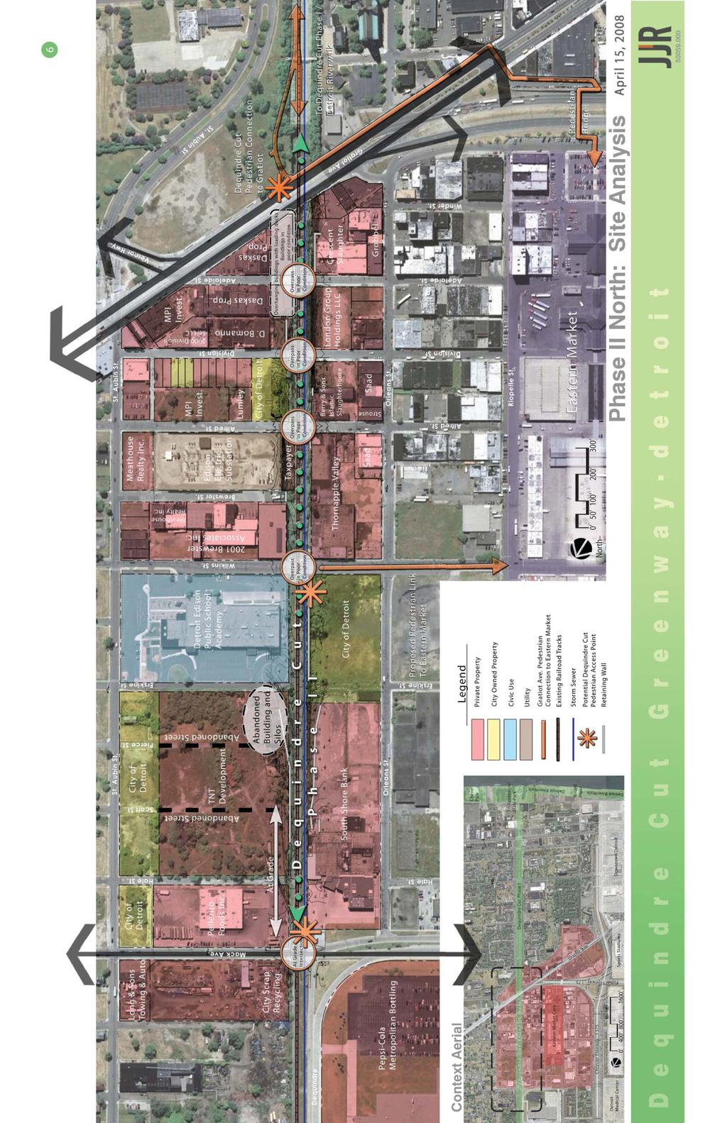
3 3 CONTENTS 1 Working Committee 2 Introduction 3 Executive Summary 4 Design Goals 7 Strategic Plan LIST OF GRAPHICS 6 Site Analysis 9 Strategic Plan View from Alfred Street bridge looking north toward Wilkins Street.
4 1 WORKING COMMITTEE City Planning Commission Greg Moots Marcell Todd Kathryn Underwood Community Foundation for Southeastern Michigan (CFSEM) Christopher Smith Sue Weckerle Tom Woiwode Detroit Edison Public School Academy (DEPSA) Ralph Bland Detroit Police Department (Northeastern District) Chester L. Logan Paul Welles Detroit Public Works (DPW) Jose Abraham Detroit Public Works / Traffic Engineering Division (DPW/TED) Sunny Jacob Ashok Patel Manilal Patel Detroit RiverFront Conservancy (DRFC) Leonard Marszalek Detroit Water and Sewer Department (DWSD) Gang Song Eastern Market Corporation (EMC) Dan Carmody Randall Fogelman Jim Sutherland Economic Development Corporation (EDC) Michael Dempsey Ron Flies Will Tamminga Greening of Detroit Ashley Atkinson Lafayette Park Neighborhood Association (LP-50) Harriet Saperstein Michigan Department of Transportation (MDOT) Vince Ranger Public Lighting Department (PLD) Stan Topolowski JJR, LLC Neal Billetdeaux Steve Buck Brian Charlton Patrick Doher

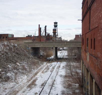
5 2 INTRODUCTION The Dequindre Cut Greenway is a non-motorized trail planned to extend from the Detroit River northward, with the future potential to connect to the Ferndale-Birmingham greenway in Oakland County. The Detroit portion of the Greenway presents a unique opportunity to encourage reinvestment in adjacent properties by re-activating an abandoned rail corridor as a recreational amenity that links the downtown area and the Detroit River, with its parks and RiverWalk, to the Eastern Market District, the University Cultural Center Area, the Midtown Loop, and a number of residential neighborhoods. Construction of Phase I of the Dequindre Cut Greenway, extending from the River one mile north to Gratiot Avenue, is almost complete. Funded by MDOT s Transportation Enhancement Program and the Community Foundation for Southeastern Michigan, this portion of the Greenway sets the template for future phases and includes a 20-foot bituminous path; access ramps for bicyclists, pedestrians and emergency vehicles; landscaping; lighting; signage and security cameras. A portion of the corridor, adjacent to the non-motorized trail, has also been reserved for future public transit. This $3 million Phase I investment will be managed and operated by the Detroit RiverFront Conservancy. The Dequindre Cut Greenway Phase II North project begins at the northern terminus of the Phase I at Gratiot Avenue and continues for over one-half mile to Mack Avenue. The Strategic Plan for Phase II provides a design approach and project budget that builds on the lessons learned in Phase I construction. The Strategic Plan goals and priorities, design alternatives, preferred options and implementation strategy were developed with the participation of a Working Committee (see page 1). The Committee included representatives from the Community Foundation for Southeastern Michigan (CFSEM), the Detroit RiverFront Conservancy (DRFC), Department of Public Works (DPW), Economic Development Corporation (EDC), Eastern Market Corporation (EMC), City of Detroit Department representatives, state agencies including the Michigan Department of Transportation (MDOT) and other stakeholders. Looking North from the Wilkins Street bridge. The Detroit Edison Public School Academy is located in the right foreground.
6 3 EXECUTIVE SUMMARY The Dequindre Cut Greenway Phase II - North Strategic Plan was developed to prepare a strategy for the planned extension of the Dequindre Cut Greenway. A Working Committee was created to guide the development process of this plan. The first step in the development of the Strategic Plan included a review and analysis of the existing conditions of the project area. The analysis identified the challenges and opportunities that currently exist on the site, including the identification of access points, land ownership, condition of adjacent properties, utilities, etc. Utilizing the information gained from the analysis and guided by a series of design goals and opportunities developed by the Working Committee, two alternatives for the greenway were designed. The alternatives were developed to provide two distinct designs to explore the potential design opportunities. The continuation of the 20 foot wide non-motorized trail established in Phase I was shown extending the length of the project. Potential access points were explored at Mack Avenue, Wilkins Street, Division Street, and Adelaide Street. In conjunction with the access points, a series of respite locations / plazas were proposed in various locations to accommodate the needs of the visitors to the greenway. The need to retain and/or repair the vehicular bridges was explored. Both of the alternatives provided ADA and universal design compatibility. The type, location, and design of site amenities and site furnishings (light fixtures, security cameras, benches, trash receptacles, etc.) were located along the trail and were consistent in style and layout to those proposed in Phase I; however were also adjusted to reflect the needs and lessons learned from Phase I. The Working Committee helped synthesize the design elements proposed in both alternatives into the Strategic Plan. The 20 foot wide non-motorized trail is located on the east side of the Dequindre Cut with an easement for a future transit corridor on the west side. Pedestrian and non-motorized access to the greenway is provided at four locations, Mack Avenue, Wilkins Street (2), and Division Street. Emergency and service vehicles have access to the greenway at Mack Avenue and Wilkins Street. A series of plaza / respite spaces are provided, each representing an opportunity to activate the recreational corridor. All four bridges are maintained within the Strategic Plan, but a strategy to fund repair and/or replacement of the bridges must be identified. Site amenities such as benches, trash receptacles, site lighting, etc. are proposed similar to those in the first phase; additional site amenities such as drinking fountains, bicycle racks, etc. have been proposed for the Phase II segment of the greenway. Informational and wayfinding kiosks / signage, trailhead signs, and trail markers will be located along the greenway. A project budget was developed to define the approximate level of funding that will be required to develop the Phase II Greenway extension as defined by the Strategic Plan. The budget is divided into eleven subcategories, encompassing the progression of the project from site preparation and demolition to finished construction. The project budget is estimated with a range of $3.5 million to $4.7 million, and will ultimately be determined by the extent of utility and bridge repair work found necessary during a detailed engineering review and by the extent of such work that might be able to be funded outside the project.


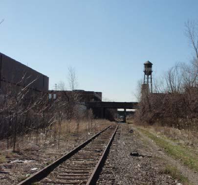
7 4 DESIGN GOALS The Working Committee developed a series of design goals to be incorporated into the proposed design of the greenway.? Connectivity > The primary goals of the Greenway are to provide for non-motorized pedestrian and bicycle transportation and to connect downtown Detroit and the Detroit River to city neighborhoods and adjacent communities.? Economic Redevelopment > The development of the Greenway should encourage reinvestment in adjacent properties and coordination with and between private property owners.? Design Continuity > The Phase II portion of the Greenway should continue the design approach and vocabulary established in Phase I.? Future Transit > An easement will be preserved along the length of the Greenway for future light rail transit.? Sustainability Opportunities and Green Strategies > Sustainable green strategies should be incorporated in the Greenway design (native landscaping; micro-habitat) and through the selection of materials/amenities, wherever possible.? Universal Design (Americans with Disabilities Act (ADA)) > The Greenway should be designed to meet and exceed ADA and universal design requirements and guidelines to maximize accessibility and use. Looking North toward Mack Avenue. The silos to be demolished are located far right in the photo. The development of the greenway could spur redevelopment of existing properties and buildings adjacent to the Dequindre Cut.

, and others.? Programmed Space > Plaza spaces, respite spots, concessions, and other programming should be incorporated.")
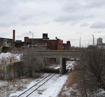
8 5? Safety > The proposed Greenway is located within a depressed rail corridor in an urban environment. Safety concerns must be addressed to make the Greenway a comfortable space to use.? Partnerships > Partnerships with existing and potential new groups should be established to assist in the financing, development, operations, and maintenance of the Greenway. > These partnerships may include the Detroit RiverFront Conservancy (DRFC), Eastern Market Corporation (EMC), Greening of Detroit, Detroit Edison Public School Academy (DEPSA), Michigan Department of Transportation (MDOT), and others.? Programmed Space > Plaza spaces, respite spots, concessions, and other programming should be incorporated.? Parking > Accommodations for parking adjacent to the Greenway should be provided to encourage its use by a wide range of patrons. > Opportunities to share existing parking lots with adjacent property owners, including Eastern Market and DEPSA, should be explored to provide this amenity.? Interpretive Signage Program > Interpretive signage to highlight the cultural and historical aspects of the area should be included in the design.? Public Art > The Dequindre Cut has a long history of graffiti artists creating murals and images on the bridge abutments and retaining walls. Phase II design should continue to allow for this form of public art in designated areas to add to the unique cultural character of the Greenway. Looking south toward Gratiot Avenue. This segment of the Dequindre Cut Greenway will connect to the recently completed Phase I segment south of the Gratiot Avenue overpass. Non-offensive graffiti provides a unique platform for public art in the Dequindre Cut
9
10 7 STRATEGIC PLAN The Working Committee helped synthesize the design elements presented in both alternatives into one strategic plan. The common elements of both alternatives are included:? A 20 foot wide non-motorized trail is located on east side of the Dequindre Cut with an easement for a future transit corridor on west. The design of the asphalt trail includes the same materials and lane designations as Phase I of the Greenway.? Site amenities (light fixtures and security cameras / emergency phones) located along the trail are consistent in style and layout to those proposed in Phase I.? DEPSA expansion onto adjacent properties to the north, and the Greening of Detroit s proposed Detroit Market Garden, are included.? Graffiti art is showcased at bridge overpasses. Other key design elements include the following:? Access to the Greenway is provided at four locations within the Phase II section: > An at grade access (pedestrian and vehicular / emergency) at the Mack Avenue terminus. > ADA compliant ramps on both the east and west sides of the Greenway from street level at Wilkins Street extending north to meet the grade of the Dequindre Cut. The ramp layout on the east side at DEPSA is a pedestrian only ramp. The ramp on the west side at the Detroit Market Garden will accommodate both pedestrians and emergency vehicles and will be coordinated with the zone provided for the future transit corridor. > An ADA compliant switchback pedestrian-only ramp from street level at Division Street to the Dequindre Cut. The ramp is proposed on property owned by the City of Detroit on the east side of the Dequindre Cut. > A pedestrian stair connection from Adelaide Street to a plaza space within the Dequindre Cut on the east side of the Dequindre Cut.? Specific high visibility areas, primarily at access points, are designated for enhanced landscape treatments.? Two plaza / respite spaces are provided in the Phase II Greenway segment: > At the lower levels of the building overhangs / loading bays near Adelaide Street on the east side. > Between the DEPSA property and the Greening of Detroit - Detroit Market Garden on the east side of the recreational trail.? A plaza is also located at the Mack Avenue trail terminus.
11 8? All four bridges are maintained. A strategy to fund repair and/or replacement must be identified. (The Alfred Street bridge is identified in the project budget to be demolished due to its current poor condition. Funding for replacement of this bridge has not been identified. The bridge could be replaced in the future.)? Site amenities, such as benches, trash receptacles, etc. are proposed for both Phases I and II. Opportunities for additional site amenities, such as drinking fountains and bicycle racks, that were not part of the Phase I development are, also identified.? Informational and wayfinding kiosks / signage will also be located within the Greenway. In addition, locations for trailhead and trail markers will be identified.
12
13 This page left intentionally blank 10

14
Potential Green Infrastructure Strategies May 6, 2015 Workshop
 Potential Green Infrastructure Strategies May 6, 2015 Workshop Background The City of Cortland is developing the Tioughnioga Urban Headwaters Green Infrastructure Action Plan with funding from the National
CHAPTER 8 ISSUES, CONCERNS, CONSTRAINTS AND OPPORTUNITIES
 CHAPTER 8 ISSUES, CONCERNS, CONSTRAINTS AND OPPORTUNITIES Introduction This River Conservation Plan was developed during a time of tremendous activity and effort in planning the transformation of the Delaware
Johnson Street Bridge Public Realm Update
 Johnson Street Bridge Public Realm Update August 20, 2015 Background Johnson Street Bridge Replacement Project impacts a diverse range of stakeholders In addition to a new bridge, the project also includes
SAFETY BY DESIGN Drives Successful Urban Greenways. Brian Charlton - SGJJR Mac McCracken - DRFC
 SAFETY BY DESIGN Drives Successful Urban Greenways Brian Charlton - SGJJR Mac McCracken - DRFC WORLD-CLASS GATHERING PLACE FOR ALL. Detroit Greenways Atwater Street and Rivard Street 2003 Atwater Street
An Ambitious Plan: Transforming the blighted South Platte River and surrounding environment into Denver s greatest natural resource.
 CONNECTING THE PEOPLE TO THEIR RIVER SOUTH PLATTE RIVER VISION IMPLEMENTATION PROGRAM: GRANT-FRONTIER PARK TO OVERLAND POND PARK REACH The South Platte River Vision Implementation Program (River Vision)
1. Parks & Recreation Neighborhood Parks Community Parks Special Use Sites 2. Open Space 3. Trails
 Appendix A: Park Classifications The intent of parks and recreation classifications is to aid in making acquisition and design decisions for park sites, facilities and the organization of recreation space
4 Park Planning and Design
 4 Park Planning and Design Park Constellations Elliot Gateway/Mills Loring North Loop Commons Twins Minneapolis Park & Recreation Board Downtown Service Area Master Plan 4-1 PROJECT APPROACH REFERENCE
Introduction. Midtown Loop. This project s purpose is to envision and design an urban greenway known as Midtown Loop for the Detroit Midtown area.
 Introduction This project s purpose is to envision and design an urban greenway known as for the Detroit Midtown area. Midtown includes the region s cultural core, historic and new neighborhoods, Wayne
Pedestrian and Bike Bridge LOGO
 6.2.2 Pedestrian and Bike Bridge The proposed pedestrian and bike crossing re-envisions the existing bridge at Pismo Creek on Cypress Street. The bridge is currently underutilized by vehicular through
Mississippi Skyway Preliminary Engineering Report
 EXECUTIVE SUMMARY Mississippi Skyway Preliminary Engineering Report CITY OF RAMSEY, MINNESOTA DECEMBER 2014 City of RAMSEY EXECUTIVE SUMMARY Project Need and Intent The Mississippi Skyway pedestrian bridge
Mendota-Lebanon Hills Greenway Master Plan Executive Summary. August draft for more information visit
 Mendota-Lebanon Hills Greenway Master Plan Executive Summary August 2013 draft for more information visit www.hkgi.com/projects/dakota INTRODUCTION The Mendota-Lebanon Hills Greenway Master Plan portrays
Corridor Vision. 1Pursue Minnehaha-Hiawatha Community Works Project. Mission of Hennepin County Community Works Program
 1Pursue Minnehaha-Hiawatha Community Works Project Minnehaha-Hiawatha Community Works is a project within the Hennepin Community Works (HCW) program. The mission of the HCW program is to enhance how the
SELMON GREENWAY FEASIBILITY STUDY. For: Hillsborough County Metropolitan Planning Organization By: Renaissance Planning
 SELMON GREENWAY FEASIBILITY STUDY For: Hillsborough County Metropolitan Planning Organization By: Renaissance Planning SELMON GREENWAY FEASIBILITY STUDY VISION Multimodal connection between Bayshore Blvd
Corridor Enhancements
 Corridor Enhancements Safety is MoDOT s first priority in widening and rebuilding I-70 across the state of Missouri. MoDOT also understands that the interstate - and its interchanges and overpasses - are
The transportation system in a community is an
 7 TRANSPORTATION The transportation system in a community is an important factor contributing to the quality of life of the residents. Without a sound transportation system to bring both goods and patrons
Dyersville Downtown Plan. Open House October 24, 2017
 Dyersville Downtown Plan Open House October 24, 2017 What is a Comprehensive Plan? - Vision - Guidance for decisions - Basis for regulations What is a Downtown Plan? - Understand priorities - Identify
Alderson, West Virginia. Prepared for the Town of Alderson. Strategic Riverfront Enhancement Plan
 Alderson, West Virginia Prepared for the Town of Alderson Strategic Riverfront Enhancement Plan March 2018 Strategic Riverfront Enhancement Plan Alderson, West Virginia Prepared for: Alderson Main Street
PUBLIC RIGHT-OF-WAY IN THIS CHAPTER PUBLIC REALM
 PUBLIC RIGHT-OF-WAY This section provides design guidelines for improvements in the public right-of-way. The public right-of-way refers to streets, sidewalks, non-vehicular thoroughfares, parks and greenways
Park Types and Attributes
 02 APPENDIX B APPENDIX B s and s 194 APPENDIX B 04 Size Level of Service Any privately owned park, of any size, is a neighborhood park Primary Service Area - 1/2 mile or within 15 minutes walking distance
Fifth and Detroit Street Design May 2017 Capital Improvements Committee. DOWNTOWN Street Design
 1 Fifth and Detroit Street Design May 2017 Capital Improvements Committee Agenda 2 Review Street Configuration Prior Meeting Review Outreach Synopsis Functional Street Design Refinements Curb Edge, Turning
Grantsburg Community Design Team (CDT)
") Grantsburg Community Design Team (CDT) Summary Report Overview On April 10-13, 2014, a team of (19) volunteer planners, design professionals, and community development educators volunteered their time
Grantsburg Community Design Team (CDT) Summary Report Overview On April 10-13, 2014, a team of (19) volunteer planners, design professionals, and community development educators volunteered their time
Charles P. Johnson and Associates. Annapolis Landscape Architects
 Charles P. Johnson and Associates Annapolis Landscape Architects AGENDA Introduction Project Limits and Scope Site Analysis Opportunities & Constraints Program Goals Image Boards Design Alternatives Pros
PLAN ELEMENTS WORKSHOP. April 5, 2016
 PLAN ELEMENTS WORKSHOP April 5, 2016 needs more housing. But there is no one-size fits-all solution. Every neighborhood has its own character. In some places, density is not only appropriate it is badly
Midtown Greenway Land Use and Development Plan Executive Summary
 Midtown Greenway Land Use and Development Plan Executive Summary Introduction The Midtown Greenway Land Use and Development Plan sets policy direction for land use and development in the Midtown Greenway
3. VISION AND GOALS. Vision Statement. Goals, Objectives and Policies
 Vision Statement Queen Creek s interconnected network of parks, trails, open spaces and recreation opportunities provide safe and diverse activities and programs that sustain its unique, small town, equestrian
PIKE PINE RENAISSANCE: ACT ONE. October 19, 2017
 PIKE PINE RENAISSANCE: ACT ONE October 19, 2017 WATERFRONT SEATTLE PROGRAM PROJECT INTRODUCTION Pike and Pine streets, between First and Melrose avenues Pedestrian and streetscape improvements Budget:
North Shore Trail. Council Meeting June 10, 2002
 North Shore Trail Council Meeting June 10, 2002 Process Guiding Principles Inventory and Analysis Preliminary Concepts (4) Final Concept Phasing Strategy Estimated Costs OVERVIEW Purpose: Prepare an overall
SPRINGHILL LAKE TRANSIT VILLAGE
 Greenbelt Metro Area Sector Plan - Subarea Design Policies and Guidelines - Springhill Lake Transit Village 113 SPRINGHILL LAKE TRANSIT VILLAGE Residential Neighborhood and Village Center CONCEPT Springhill
METROPOLITAN COUNCIL 390 North Robert Street, St. Paul, MN Phone (651) ; TDD (651)
 ; TDD (651)") DATE: December 20, 2011 METROPOLITAN COUNCIL 390 North Robert Street, St. Paul, MN 55101 Phone (651) 602-1000; TDD (651) 291-0904 TO: Metropolitan Parks and Open Space Commission FROM: Tori Dupre, Senior
DATE: December 20, 2011 METROPOLITAN COUNCIL 390 North Robert Street, St. Paul, MN 55101 Phone (651) 602-1000; TDD (651) 291-0904 TO: Metropolitan Parks and Open Space Commission FROM: Tori Dupre, Senior
Landscape and Streetscape Design 2.5
 Landscape and Streetscape Design 2.5 2.5.1 Goals 2.5.2 Planting 2.5.3 Sidewalks and Pavement 2.5.4 Furnishings 2.5.5 Walls 2.5.6 Lighting 2.5.7 Stormwater 2.5.8 Street Cross Sections 2.5 LANDSCAPE AND
8implementation. strategies
 PROGRAM STRATEGIES 8implementation strategies T he implementation actions of this chapter are designed to support and carry out the land use, economic development, transportation, urban design, and program
Metropolitan Parks and Open Space Commission
 Business Item No. 2013-xxx Metropolitan Parks and Open Space Commission Meeting date: October 1, 2013 For the Community Development Committee meeting of October 7, 2013 Subject: Mendota-Lebanon Hills Greenway
5. Father Hennepin Blufs Park and Hennepin Island Father Hennepin Bluffs Park Supporting Initiatives (see Figure 36): 7-22
: 7-22") 5. Father Hennepin Blufs Park and Hennepin Island As described in existing conditions portion of Chapter 2, Father Hennepin Blufs Park lies on the upland portion of the park and Hennepin Island spans the
5. Father Hennepin Blufs Park and Hennepin Island As described in existing conditions portion of Chapter 2, Father Hennepin Blufs Park lies on the upland portion of the park and Hennepin Island spans the
Long Branch-Wayne Local Park Renovation Project
 Montgomery Parks Long Branch-Wayne Local Park Renovation Project Community Meeting #2 September 20, 2016 Oak View Elementary School 7:00-9:00 PM Welcome / Team Introductions M-NCPPC (Montgomery Parks)
DRAFT ROOSEVELT ROAD. District Recommendations. Figure 5.23 The Roosevelt Road Corridor
 CHAPTER 5 Figure 5.23 The Road Corridor Road will develop as a mixed-use corridor, emphasizing regional retail, west of the river and mixed-use development east of the river. KEY RECOMMENDATIONS 1. High
The Vision. Photo provided by The Minervini Group. 46 Vision, Objectives & Strategies
 Vision, Objectives & Strategies The is the public framework and guide for future development of the Grand Traverse Commons. The establishes public polices for infrastructure, the preservation of natural
CHAPTER 3 VISION, GOALS, & PLANNING PRINCIPLES. City of Greensburg Comprehensive Plan. Introduction. Vision Statement. Growth Management Goals.
 CHAPTER 3 VISION, GOALS, & PLANNING PRINCIPLES Introduction The Greensburg Comprehensive Plan is intended as a working community document. A combination of long and short-term goals, this document is intended
WOONASQUATUCKET RIVER WATERSHED COUNCIL REQUEST FOR PROPOSALS DESIGN OF GREENWAY PALETTE, SIGNAGE AND AMENITIES
 WOONASQUATUCKET RIVER WATERSHED COUNCIL REQUEST FOR PROPOSALS DESIGN OF GREENWAY PALETTE, SIGNAGE AND AMENITIES PROJECT BACKGROUND The Woonasquatucket River Watershed Council (WRWC) is a 501(c)3 organization
1.0 Circulation Element
 5/9/18 1.0 Circulation Element 1.1 Introduction As growth and development occur in Apache County, enhancements to its circulation system will be necessary. With time, more roads will be paved and air and
Noblesville Alternative Transportation Plan 2015
 Noblesville Alternative Transportation Plan 2015 Noblesville Alternative Transportation Plan 2015 This report document was prepared under Contract for the Noblesville Department of Parks and Recreation
M E M O R A N D U M. DATE: July 19, Patrick D. O Keeffe, City Manager. Economic Development & Housing
 M E M O R A N D U M DATE: July 19, 2011 TO: FROM: Patrick D. O Keeffe, City Manager Economic Development & Housing SUBJECT: Resolution of the City Council of the City of Emeryville Approving the Application
City of Plattsburgh DRI: Downtown Streetscapes & Riverfront Access. Downtown Streetscape and Riverfront Access Design
 City of Plattsburgh DRI: Downtown Streetscapes & Riverfront Access Welcome Thank you for coming this evening. Agenda PART I - Project Context The Downtown Revitalization Program Our DRI Projects Other
1 st now. Design Elements. iii STREET TREES PATTERNED CROSSWALKS SPECIAL SIDEWALK PAVING. First Street ELEMENTS TRANSIT SHELTER / LANTERN
 Design Elements A framework for Design Elements has been developed in response to Project Restore s vision and goals for the First Street Corridor. Guided by the principles good urban design and smart
July 12, Columbus City Council City Hall 90 West Broad Street Columbus, OH RE: I-70/71 Columbus Crossroads Project
 OHIO DEPARTMENT OF TRANSPORTATION DISTRICT 6 400 EAST WILLIAM STREET DELAWARE, OHIO 43015 800.372.7714 Columbus City Council City Hall 90 West Broad Street Columbus, OH 43215-9015 RE: I-70/71 Columbus
Sheridan Boulevard S TAT I O N A R E A P L A N S H E R I D A N B O U L E VA R D S TAT I O N A R E A P L A N
 Sheridan Boulevard S TAT I O N A R E A P L A N 1 City of Lakewood Adopted November, 2006 S H E R I D A N B O U L E VA R D S TAT I O N A R E A P L A N The Vision The City of Lakewood s overall vision is
Whittier Greenway Trail. Est. 2009
 Whittier Greenway Trail Est. 2009 The Whittier Greenway Trail begins in the northwest corner of Whittier, near the 605 Freeway, and closely parallels Whittier Boulevard. When it reaches Painter Avenue,
east riverfront Framework Plan update March 1, 2017
 YOUR! detroit east riverfront Framework Plan update March 1, 2017 Support for the East Riverfront Framework Plan provided by: 2 a riverfront for everyone 3 community driven framework 4 Strategy #1: Parks
BUSINESS DISTRICT DESIGN GUIDELINES
 Des Plaines, Illinois Prepared for the City of Des Plaines by: The Lakota Group Laurie Marston, AICP March 2005 Section 5: Streetscape Elements Business District Design Guidelines STREETSCAPE ELEMENTS
FDOT D4 Complete Streets
 FDOT D4 Complete Streets Context Sensitive Solutions Directs that complete street solutions will complement the context of the community. Collaborative approach to decision making, project development,
METROPOLITAN COUNCIL 390 North Robert Street, St. Paul, MN Phone (651) ; TDD (651)
 ; TDD (651)") DATE: October 24, 2012 METROPOLITAN COUNCIL 390 North Robert Street, St. Paul, MN 55101 Phone (651) 602-1000; TDD (651) 291-0904 TO: Metropolitan Parks and Open Space Commission FROM: Tori Dupre, Senior
DATE: October 24, 2012 METROPOLITAN COUNCIL 390 North Robert Street, St. Paul, MN 55101 Phone (651) 602-1000; TDD (651) 291-0904 TO: Metropolitan Parks and Open Space Commission FROM: Tori Dupre, Senior
RECREATION AND OPEN SPACE ELEMENT GOALS, OBJECTIVES, AND POLICIES
 RECREATION AND OPEN SPACE ELEMENT GOALS, OBJECTIVES, AND POLICIES Goal 7 To provide park facilities, recreation programs, and open space resources that are safe, adequate, and accessible to all City residents,
V. Gateways GATEWAYS / V-1
 V. GATEWAYS / V-1 Many of Chesapeake s gateways are located on highways and call for bold and attractive designs that motorists can understand, appreciate, and enjoy. can also take the form of natural
DRAFT. Waterfronts and Open Spaces. 10 The Riverfront Open Space System
 CHAPTER 4 Waterfronts and Open Spaces 10 The Riverfront Open Space System 12 Planned, proposed and envisioned riverfront recommendations. Figure 4.3.23 The riverfront will become a major new public amenity
MEETING MINUTES East Carolina University Comprehensive Master Plan Page 1 of 1
 Page 1 of 1 26472.J00 04.06.2009 04.24.2009 PROJECT PROJECT NO. MEETING DATE ISSUE DATE Health Sciences Building Open House-West Campus Location MEETING LOCATION MEETING PURPOSE Ryan Podvin ISSUED BY SIGNATURE
Study Area. Capitol Way. Greening America s Capitals 11/13/2014. A Greening America s Capitals Project
 Olympia, WA: Greening Capitol Way Supporting Communities move towards sustainability is a priority for the federal government. A Greening America s Capitals Project Office of Sustainable Communities U.S.
Submitted by: Dan Marks, Director, Planning and Development Department. Aquatic Park Connection Streetscape Improvement Design Development Approval
 Office of the Executive Officer ACTION CALENDAR December 5, 2006 To: From: Honorable Chairperson and Members of the Redevelopment Agency Phil Kamlarz, Executive Officer Submitted by: Dan Marks, Director,
Project purpose. advise. The purpose of the Beaumaris Lake Open Space Rehabilitation project is to: + Develop a Functional Program Concept
 Project purpose owns Road Beaumaris Road The purpose of the Beaumaris Lake Open Space Rehabilitation project is to: + Develop a Functional Program Concept + Guide Rehabilitation of Landscape and Community
CHAPTER 7: Transportation, Mobility and Circulation
 AGLE AREA COMMUNITY Plan CHAPTER 7 CHAPTER 7: Transportation, Mobility and Circulation Transportation, Mobility and Circulation The purpose of the Transportation, Mobility and Circulation Chapter is to
Roosevelt Corridor. R e i n v e s t m e n t P l a n. Public Meeting Gilbert Elementary School May 12, :00 pm
 Roosevelt Corridor R e i n v e s t m e n t P l a n Public Meeting Gilbert Elementary School May 12, 2009 6:00 pm Agenda 6:00 6:10 6:25 6:40 6:55 7:00 Opening Comments Councilwoman Jennifer V. Ramos District
ALMONO. Hazelwood, City of Pittsburgh. A riverfront investment opportunity combining residential, office and light industrial uses A L M O N O S I T E
 Tecumseh St. ALMONO Hazelwood, City of Pittsburgh A riverfront investment opportunity combining residential, office and light industrial uses Downtown Pittsburgh Oakland South Side Flats Birmingham Bridge
Greenway. Two Rivers. Design Guidelines and Signage Plan. Broome County. Tioga County. Prepared For: The Binghamton Metropolitan Transportation Study
 Broome County Two Rivers Greenway Design Guidelines and Signage Plan Tioga County Prepared For: The Binghamton Metropolitan Transportation Study Prepared By: 2012 This project is included in the 2011-2012
TRANSPORTATION ELEMENT
 TRANSPORTATION ELEMENT GOAL I: To create and maintain a safe, efficient and aesthetic transportation system that encourages multi-modal transportation and promotes the mobility strategies of the Ocala
PROJECT BACKGROUND. Preliminary Design Scope and Tasks
 PROJECT BACKGROUND Preliminary Design Scope and Tasks The purpose of this Study is the development of preliminary designs for intersection improvements for Trunk Highway (TH) 36 at the intersections of
Table of Contents. Elm Avenue Improvement Plan City of Waco, Texas. Introduction 1. Existing Context 1 Figure 1 2.
 Table of Contents Introduction 1 Existing Context 1 Figure 1 2 Plan Guidelines 3 Future Urban Form 4 The West-End 4 Main Street 6 The East-End 7 Figure 2 9 Public Improvement Recommendations 7 General
Kenilworth Avenue and Town of Cheverly Industrial Study Briefing
 Kenilworth Avenue and Town of Cheverly Industrial Study Briefing The Maryland-National Capital Park and Planning Commission Prince George s County Planning Department www.pgplanning.org Vanasse Hangen
The Lower SaLuda Greenway
 The Lower SaLuda Greenway InITIaTIve a FLourIShInG Greenway. a hub For economic GrowTh. a ConneCTIon BeTween CoMMunITIeS. In April 2017 the Michael J. Mungo Foundation and Lexington County commissioned
Downtown Cleveland Alliance/Tremont
 Cleveland Innerbelt Urban Design Stakeholder Workshops Downtown Cleveland Alliance/Tremont May 4, 2007 2007 Activities: What We re Going To Be Doing. March 8, 2007 Initiate Urban Design Aesthetic Study
Our Legacy Projects DOWNTOWN JACKSONVILLE MASTER PLAN
 DOWNTOWN JACKSONVILLE MASTER PLAN A major component of our master plan is the creation of a strong and accessible open space and recreation system. The four most vital links in that system are our legacy
The Auburn Plan Designing the Future of Auburn February 28, 2005
 The Auburn Plan Designing the Future of Auburn February 28, 2005 Block-by-Block Bicycle Tour Aerial survey Focus Group Meetings September 7 and 8 Design Workshops October 11, 14, and 21 Revitalization
Illustration of Eastlake Farmer s Cooperative Grain Elevator. Chapter 5: implementation 5-1
 Illustration of Eastlake Farmer s Cooperative Grain Elevator Chapter 5: implementation 5-1 chapter 5: implementation Introduction The Eastlake Subarea Plan includes a wide range of recommendations intended
HILLSBOROUGH COUNTY Greenways and Trails Plan Update. Executive Summary. Date
 HILLSBOROUGH COUNTY Greenways and Trails Plan Update Executive Summary Date PURPOSE AND PROJECT OVERVIEW The Hillsborough County Greenways Master Plan (1995) and the City of Tampa s Greenways and Trails
TOWN COUNCIL / PLANNING COMMISSION
 Workshop #3 TOWN COUNCIL / PLANNING COMMISSION January 20, 2011 Consultant Team In Attendance Tonight BMS Design Group Nevada City and San Francisco Michael Smiley, AICP, ASLA Partner-in-Charge Nancy L.
W&OD PARK MASTER PLAN. The City s Greenest Street. DRAFT W&OD Trail Master Plan v4.docx Page 1
 W&OD PARK MASTER PLAN Adopted XXX-XX-XXXX The City s Greenest Street DRAFT W&OD Trail Master Plan v4.docx Page 1 Introduction and Purpose The Washington & Old Dominion Railroad Regional Park (W&OD) (which
Presenting a Vision for Thread Lake
 Presenting a Vision for Thread Lake FEBRUARY 20, 2014 SPECIAL THANKS TO: International Academy of Flint Flint River Watershed Coalition South Saginaw Business and Resident Association South Side Neighborhood
PARKLET PROPOSAL PACKAGE & PROCESS
 500.3 I PARKLETS The term parklet refers to a small temporary constructed seating or community gathering area over an on-street parking space or an extension of the sidewalk into the operating State highway
Today Land & People. Northeast Nampa Gateway District. Employment. Land Use Characteristics. Demographics. Current Zoning
 Today Land & People Employment Major employers include Saint Alphonsus, the College of Western Idaho, the Auto Mall, Sorrento Lactalis and Walmart. 3,004 jobs in 2010 (COMPASS-CIM 2040 TAZ data) 4,345
Mendota Heights 2040 Comprehensive Plan Draft Vers
 4 Parks and Trails The City of Mendota Heights boasts a variety of recreational and open space opportunities. Few cities can claim access to regional trails, riverside and lakeside parks, scenic bluffs
PROJECTS AND THE PUBLIC ART MASTER PLAN
 MEMO TO: PUBLIC ART STEERING COMMITTEE MEMBERS FROM: SHARI COOPER, DEVELOPMENT PROJECT COORDINATOR DATE: FEBRUARY 24, 2017 SUBJECT: AGENDA ITEM 5.A: PUBLIC ART PROJECT FOR 2017-18 BACKGROUND One of the
... the real city lives on... Character Area 5: LOWER WASHINGTON
 ... the real city lives on... Character Area 5: LOWER WASHINGTON 89 Boundaries This area is bordered by the extension of Fair Way to the north, the Napa River to the south, Gerard Street/Fire Station parking
Downtown Dubuque...it s a great time.
 Downtown Dubuque...it s a great time. Your timing could not be better to invest in Downtown. With hundreds of millions in public and private investment occurring on the City s downtown waterfront, millions
APPENDIX I: GREENWAY DESIGN STANDARDS
 APPENDIX I: GREENWAY DESIGN STANDARDS The goal of this report is to develop a palette of standard design elements that will help establish a distinct identify for the Bronx River Greenway. The greenway
Committee Meeting: Downtown Today & Concept Refinement September 11, 2017
 Committee Meeting: Downtown Today & Concept Refinement September 11, 2017 AGENDA 1. Brief Input Update 2. Comprehensive Plan Principles 3. Downtown Today 4. Concept Updates 5. Future Schedule What is a
Wadsworth Boulevard S TAT I O N A R E A P L A N
 Wadsworth Boulevard S TAT I O N A R E A P L A N City of Lakewood Adopted November, 2006 The Vision The City of Lakewood s overall vision is to transform the area around the light rail station into a mixed-use
COMMUNICATION URBAN DESIGN REVIEW BOARD CITY OF DES MOINES, IOWA MAY 16, 2017 MEETING
 COMMUNICATION URBAN DESIGN REVIEW BOARD CITY OF DES MOINES, IOWA MAY 16, 2017 MEETING Subject: Recommendation Prepared by: PRELIMINARY DESIGN REVIEW OF LOCUST STREET BRIDGE CONSTRUCTION & COURT AVENUE,
Ashland BRT Environmental Assessment: logos of CTA, CDOT, Chicago Department of Housing and Economic Development
 Ashland BRT Environmental Assessment: logos of CTA, CDOT, Chicago Department of Housing and Economic Development Overview The Chicago Transit Authority (CTA), in partnership with the Chicago Department
DOWNTOWN PARKS & PUBLIC REALM PLAN
 DOWNTOWN PARKS & PUBLIC REALM PLAN CHALLENGES The Parks and Public Realm Strategy addresses challenges associated with a growing Downtown, including: GOALS 3.3 New buildings will fit within their existing
TRANSPORTATION PROJECTS
 TRANSPORTATION PROJECTS 40 BUFFALO S LWRP PROPOSED PROJECTS T1. Niagara Street/Great Lakes Seaway Trail Streetscape Project City of Buffalo Department of Public Works Niagara Street from Niagara Square
CAMPUS MASTER PLAN DRAFT PLAN UPDATE JANUARY
 NEW MEXICO HIGHLANDS UNIVERSITY CAMPUS MASTER PLAN DRAFT PLAN UPDATE JANUARY 27 2010 MASTER PLANNING GOALS TO BALANCE THE STRATEGIC GOALS OF THE UNIVERSITY WITH THE PHYSICAL CAMPUS through the assessment
Rosemount Greenway Master Plan Executive Summary. draft. Spring for more information visit
 Rosemount Greenway Master Plan Executive Summary Spring 2012 draft for more information visit www.hkgi.com/projects/dakota INTRODUCTION The Rosemount Greenway Master Plan portrays a vision to establish
Business Item No
 Community Development Committee For the Community Development Committee meeting of December 19, 2016 For the Metropolitan Council meeting of January 11, 2017 Business Item No. 2016-255 Subject: River to
FREEWAY/TOURIST DISTRICT
 FREEWAY/TOURIST DISTRICT DESIGN STANDARDS FOR THE CITY OF MOUNTLAKE TERRACE March, 2014 MOUNTLAKE TERRACE FREEWAY/TOURIST DESIGN STANDARDS March, 2014 1 TABLE OF CONTENTS Introduction...1 Design Site Design
Harlem Avenue Corridor Plan: Corridor Planning Across Municipal Boundaries
 Harlem Avenue Corridor Plan: Corridor Planning Across Municipal Boundaries Heather Tabbert, Manager, Local Planning and Programs Division Regional Transportation Authority (RTA) Jen McNeil Dhadwal, Principal
The University District envisions, in its neighborhood
 Envisioning the University District Link Light Rail in Seattle s neighborhoods CIY OF SEALE CONCEP-LEVEL SAION AREA PLANNING RECOMMENDAION RESOLUION # 30165 EXHIBI L Vision 08.2000 he University District
ARROYO PROJECTS ADOPTED CAPITAL IMPROVEMENT PROGRAM BUDGET
 A RROYO P ROJECTS ADOPTED CAPITAL IMPROVEMENT PROGRAM BUDGET FISCAL YEARS 214-218 HAHAMONGNA Priority Description 1 Hahamongna Watershed Park - Implement Master Plan 211,6 211,6 (77565) 2 Hahamongna -
SH 199 Corridor Master Plan. Community Meeting No. 2 May 31, 2017
 Community Meeting No. 2 May 31, 2017 Transportation Projects On or Near SH 199 SH 199 from 0.3 miles south of FM 1886 to south end of Lake Worth bridge Construct freeway mainlanes and frontage roads 10-Year
Fall Creek Greenway. Indy Greenways Master Plan
 Fall Creek Greenway 168 Indy Greenways Master Plan chapter four DESIGN STANDARDS DESIGN STANDARDS 169 chapter four DESIGN STANDARDS inside this chapter: INTRODUCTION..............................................
City of Missoula and Missoula County Open Space Planning Open House
 City of Missoula and Missoula County Open Space Planning Open House FEBRUARY 6, 2018 The following slides contain the display board content from the open house. Please use boards to answer questions in
Planning for Waterfront Communities
 Planning for Waterfront Communities Redevelopment Ready Communities Supplemental Training Program OFFICE OF THE GREAT LAKES Waterfront Community Best Practices and Guidelines New supplemental criteria
SUBCHAPTER 4-B GUIDELINES FOR THE B-3 COMMERCIAL CHARACTER AREA
 1 SUBCHAPTER 4-B GUIDELINES FOR THE B-3 COMMERCIAL CHARACTER AREA Downtown Bozeman should be the location of buildings of greatest height and intensity in the community. The following guidelines apply
Creation of Confluence Park and Input from Vermont River Conservancy
 CITY COUNCIL Agenda Item #18-236 Date: August 22, 2018 Consent Discussion X SUBJECT: Creation of Confluence Park and Input from Vermont River Conservancy SUBMITTING DEPARTMENT: Mayor RECOMMENDED ACTION: