North Hertfordshire Green Belt Review
|
|
|
- Julius Austen Ryan
- 5 years ago
- Views:
Transcription

1 North Hertfordshire Green Belt Review July 2016 North Hertfordshire Local Plan Evidence Base Report
2 2
3 Contents 1. Background and Approach to the Review. PART ONE: ASSESSMENT OF THE CURRENT GREEN BELT, VILLAGES IN THE GREEN BELT AND POTENTIAL DEVELOPMENT SITES IN THE GREEN BELT 2. Strategic Review of the Green Belt Background to Review 2.2 Role and purpose of Green Belt 2.3 The National Planning Policy Framework (NPPF) 2.4 Methodology 2.5 Assessment - existing Green Belt 2.6 Checking the unrestricted sprawl of large built-up areas 2.7 Preventing neighbouring towns merging into one another 2.8 Safeguarding the countryside from encroachment 2.9 Preserving the setting and special character of Historic Towns 2.10 Overall contribution to Green Belt purposes 3. Refined Review of the Green Belt Analysis of Villages in the Green Belt Purpose and Method of Appraisal 4.2 NHDC Proposed Policy Context 4.3 Analysis of to the Green Belt 5. Analysis of Potential Development Sites in the Green Belt. 5.1 Introduction 5.2 Methodology - potential development sites 5.3 Assessment of Potential Development Sites PART TWO: ASSESSMENT OF POTENTIAL ADDITIONS TO THE GREEN BELT 6. Assessment of Countryside beyond the Green Belt Introduction 6.2 Role and purpose of Green Belt 6.3 Methodology potential Green Belt areas 6.4 Site Visits 6.5 Assessment against Green Belt purposes 6.6 Checking the unrestricted sprawl of large built-up areas 6.7 Preventing neighbouring towns merging into one another 6.8 Assisting in safeguarding the countryside from encroachment 6.9 Preserving the setting and special character of Historic Towns 6.10 Conclusions on Potential Areas for Inclusion 6.11 Village Analysis Tables and Figures Table 2.1: The Green Belt Review Process Table 2.2: Green Belt Assessment Criteria Table 2.3: Assessment Criteria Table 2.4: Strategic Assessment of the Existing Green Belt 3
4 Table 3.1: Assessment of to Green Belt Purposes of the Parcels and Sub-Parcels Table 4.1: Summary Assessment of to Green Belt Purposes and Potential for Insetting Table 5.1: Summary of Approach to Assessing Potential Development Sites Table 5.2: Site Assessment Criteria Table 5.3: Assessment of Potential Development Sites by Green Belt Purpose Table 6.1: Overall Methodology for Assessing Countryside Beyond the Green Belt Table 6.2: Assessment of Green Belt Table 6.3: Assessment score Table 6.4: Overall assessment for each parcel Table 6.5: Assessment of Potential Additions to the Green Belt Table 6.6: Overview of Key Results Table 6.7: Summary Assessment of the Potential of Villages to an Extended Green Belt Figure 2.1: The Metropolitan Green Belt Figure 2.2: The Green Belt in North Hertfordshire Figure 2.3: Green Belt Review study areas Figure 2.4: to checking the unrestricted sprawl of large built-up areas Figure 2.5: to Preventing Neighbouring Towns Merging into one Another Figure 2.6: to Safeguarding the Countryside from Encroachment Figure 2.7: to Preserving the Setting and Character of Historic Towns Figure 2.8: Overall contribution to Green Belt purposes Figure 3.1: Sub-parcels for Review Figure 3.2: to checking the unrestricted sprawl of large built-up areas Figure 3.3: to Preventing Neighbouring Towns Merging Figure 3.4: to Safeguarding the Countryside from Encroachment Figure 3.5: to Preserving the Setting and Character of Historic Towns Figure 3.6: Overall contribution to Green Belt purposes Figure 4.1: Villages in the Green Belt Assessed for Potential Insetting Figure 5.1: Potential Development Sites Considered in the Green Belt Review Figure 6.1: Study area for land with potential for inclusion in the Green Belt Figure 6.2: Checking the unrestricted sprawl of large built-up areas Figure 6.3: Preventing neighbouring towns merging into one another Figure 6.4: Assisting in Safeguarding the Countryside from Encroachment Figure 6.5: to preserving the setting and special character of historic towns Figure 6.6: Overall to Green Belt purposes 4
5 1. Background and Approach to the Review 1. The document brings together in one place Green Belt Review documents previously consulted upon 1 and incorporates amendments made in light of those consultations. The Green Belt Review was carried out in 2013/14 to assess the contribution of Green Belt land within North Hertfordshire to the functions of Green Belt as set out in paragraph 80 of the National Planning Policy Framework (NPPF). The Review tests proposed development sites against Green Belt purposes and also considers the case for designating additional Green Belt. The Green Belt Review forms part of the evidence base in support of the North Hertfordshire Local Plan. 2. The opportunity has been taken in this document to clarify and to add material where appropriate. This relates principally to a refined assessment using smaller scale parcels which provides more detailed context for the evaluation of proposed sites, and an assessment of the potential for insetting villages within the Green Belt in response to the requirements of the NPPF. 3. There is no nationally specified methodology for undertaking a Green Belt Review and that used in this Review draws on studies undertaken across the country. It is intended to be an objective study which will sit alongside others as part of the Local Plan evidence base as a whole. As such the document needs to read in conjunction with those studies which collectively inform the spatial strategy and site selection process, All the evidence base studies are available at: 4. The document has been produced with the assistance of Amec Foster Wheeler. 5. The Green Belt review is split into two parts: Part 1 is a strategic level review of the current Green Belt and a more detailed assessment of potential development sites; and Part 2 is an assessment of countryside beyond the Green Belt which could have the potential to be designated as Green Belt 1 Green Belt Review (November 2014) Part 1: Assessment of current Green Belt and Potential Development Sites in the Green Belt and Part 2: Assessment of countryside beyond the Green Belt 5
6 6
7 PART ONE: ASSESSMENT OF THE CURRENT GREEN BELT, VILLAGES IN THE GREEN BELT AND POTENTIAL DEVELOPMENT SITES IN THE GREEN BELT 7
8 8
9 2. Strategic Review of the Green Belt in North Hertfordshire 2.1 Background to Review 1. North Hertfordshire District Council is preparing a new Local Plan. The Green Belt review will inform the emerging Local Plan and provide background evidence to support the land allocations, guide policy formation, assist in the discussions on development pressures with other authorities, identify any potential changes to the Green Belt boundary and aid rationalisation of the Green Belt area in North Hertfordshire. 2. The last time the Green Belt in North Hertfordshire was reviewed was in 1992 when the Planning Inspector ruled that any changes should be in conformity to the prevailing County Structure Plan. The Structure Plan was replaced by the East of England Regional Spatial Strategy which itself was revoked in Without a regional or county plan changes to the Green Belt are now the responsibility of the Local Authority. 3. This is an appropriate time to undertake a Green Belt review in order to inform and manage, in a positive way, changes that are taking place. There are growing development pressures within the district, this coupled with limited brownfield sites or sites within North Hertfordshire settlement boundaries available for development means that areas within the Green Belt are potentially needed to accommodate new housing and related development. 4. Green Belt reviews recently undertaken by neighbouring authorities have been assessed in order to aid consistency and understanding across reviews of the Green Belt in Hertfordshire and adjoining areas, these include: Review of the Green Belt around Stevenage: Part 1 Survey against Green Belt Purposes (February 2013) East Herts District-Wide Green Belt Review Part 1 (September 2013) and Parts 2 6 (December 2013) Dacorum/St Albans/Welwyn Hatfield Independent Green Belt Review Part 1 (October 2013) and Part 2 Sites and Boundaries Study. Luton draft Green Belt Review (2013) 5. There are two areas of non-green Belt in the district, the area to the east of Baldock and the area between the two bands of Green Belt around Luton and around Stevenage/Hitchin. Only the non Green Belt area in the western part of the district was assessed in detail. Consideration was given to the eastern part but there is only one town, Royston, and scattered villages, which are isolated in the sense that development pressures and sustainable development would have a lower impact and land is less likely to contribute to Green Belt objectives in the way that it might closer to the other three towns in the district 6. It should be noted that in this assessment, for Green Belt Review purposes, Baldock, Letchworth and Hitchin are classed as historic towns. For Green Belt Review purposes only, Knebworth has been defined as a town, based on its population of around 4,500 and its range of facilities including a railway station. 2.2 Role and purpose of Green Belt 7. The NPPF (para 80) sets out five purposes to Green Belt To check the unrestricted sprawl of large built-up areas; 9

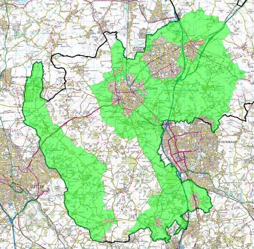
10 To prevent neighbouring towns merging into one another; To assist in safeguarding the countryside from encroachment; To preserve the setting and special character of historic towns; and To assist in urban regeneration by encouraging the recycling of derelict and other urban land 8. The current designated area of Green Belt in North Hertfordshire is 14,247ha out of a total district area of 37,537ha (approx 38%). The Green Belt coverage for Hertfordshire as a whole is approximately 90,000ha out of a total area for the County of 164,300ha (approx. 55%). 9. The London Metropolitan Green Belt has been progressively extended since a first phase of designation in Hertfordshire County Council initially designated the south of the county as Green Belt as part of the Hertfordshire County Development Plan published in 1951 and approved in The first review of the County Development Plan, published in 1964 and approved in 1971, extended the Green Belt to the north of the county along the A1(M) corridor (Figure 2.1). Figure 2.1: The Metropolitan Green Belt source: CPRE ( 10. The Hertfordshire County Structure Plan in 1979 approved in principle the designation of a Green Belt as part of the Metropolitan Green Belt about miles deep with limited extensions along the main radial transport corridors. This included the area of Metropolitan Green Belt that extends into North Hertfordshire District surrounding Stevenage, Hitchin, Letchworth Garden City and Baldock. 10
11 11. The Hertfordshire County Structure Plan Alterations Number 1 in 1984 approved the principle of a Green Belt in Hertfordshire to the east of Luton to link with the Green Belt approved in the Bedfordshire County Structure Plan. 12. The Strategic Plan for the South East presented the regional arguments for Green Belt policy in particular how London's influence had extended since the Metropolitan Green Belt was first defined and how the resultant development pressures in Hertfordshire could only be met at the expense of Hertfordshire's environment unless positive policies were available to divert them to growth areas elsewhere. 13. These piecemeal extensions of the Green Belt in Hertfordshire have resulted in the two separate areas of Green Belt that currently exist within North Hertfordshire district (Figure 2.2). 11

12 North Hertfordshire Green Belt Review July 2016 Figure 2.2: The Green Belt in North Hertfordshire 12
13 2.3 The National Planning Policy Framework (NPPF) 14. As set out in the NPPF, the essential characteristics of Green Belts are their openness and their permanence. 15. The NPPF states that Green Belt boundaries should only be altered in exceptional circumstances, through the preparation or review of the Local Plan. At that time, authorities should consider the Green Belt boundaries having regard to their intended permanence in the long term, so that they are capable of enduring beyond the plan in the long term. (paragraph 83) 16. The NPPF goes on to state in paragraph 84 that when drawing up or reviewing Green Belt boundaries local planning authorities should take account of the need to promote sustainable patterns of development. They should consider the consequences for sustainable development of channelling development towards urban areas inside the Green Belt boundary, towards towns and villages inset within the Green Belt or towards locations beyond the outer Green Belt boundary. It is therefore important to consider the sustainability implications of reviewing the Green Belt for growth around urban areas compared with directing growth to locations beyond the Green Belt. 17. The levels of growth required in North Herts and lack of suitable brownfield sites or sites within settlement areas will mean that it is not possible to accommodate all the needs in sustainable locations outside of the Green Belt. This is set out in more detail in the Sustainability Appraisal of the Preferred Options Local Plan Methodology 18. The strategic assessment of the existing Green Belt followed a staged approach as set out in Table 2.1. Table 2.1: The Green Belt Review Process Strategic assessment Explanation Review of recent Green Belt studies Desktop study to identify scope of review of Green Belt land Assessment against Green Belt principles Site visits Conclusion Consider neighbouring authority Green Belt reviews to ensure consistency in approach. Define parcels of land within the North Hertfordshire Green Belt based on topography; physical characteristics; roads; railway lines; etc to form a basis for assessment. Assess parcels against four of the five Green Belt purposes. (Note that the fifth purpose has not been considered as the other four purposes are all deemed to contribute to urban regeneration). Check appropriateness of land parcels and existing boundaries and assessment. Bring together the assessments for each of the four purposes to provide an overall evaluation of the contribution of the parcels to the Green Belt. 2 SA/SEA of the North Hertfordshire Local Plan Preferred Options (CAG Consulting, November 2014) 13
14 19. There have been a number of Green Belt Reviews undertaken in adjoining areas, Stevenage, East Hertfordshire, Luton, Central Bedfordshire and a joint review for Dacorum/St Albans/Welwyn Hatfield. 20. The most relevant to this study is the Stevenage review which partly overlaps with this review. The Stevenage study also assessed four areas not currently Green Belt for their possible designation as Green Belt either to make the Green Belt more coherent through the use of strong boundaries or to compensate for potential removal of areas. One of these areas is in North Hertfordshire adjoining the A1(M). The recommendation in the Stevenage study for the area in North Hertfordshire states that the argument for designation rests on the reinforcement of the outer boundary of the Green Belt to the west. Whether designation should fill in the whole of the land between Stevenage and Luton up to the A505 or just part of this land would need to be subject to a separate study to find appropriate boundaries. This question is addressed in this Review. 14

15 Figure 2.3: Green Belt Review study areas 15
16 2.4.1 Desktop Study to identify scope of the review 1. The current area of Green Belt within North Hertfordshire is in two separate parts. The eastern section wraps around the three settlements of Hitchin, Letchworth and Baldock and then follows the A1(M) corridor south along the western edge of Stevenage and envelopes the settlements of Knebworth and Codicote. The western section adjoins the eastern edge of Luton and follows the western boundary of the district southwards towards Kimpton. 2. These two parts are separated by a narrow belt of land, approximately 3km wide, which runs from the district boundary in the south, between Blackmore End and Ayot St. Lawrence, to the district boundary in the north. This area of non-green Belt land covers a number of small settlements including Whitwell, Preston, Offley and Pirton. The depth of the Green Belt in North Hertfordshire ranges from less than 1km around Hitchin, Letchworth and Stevenage, to up to 4km around parts of Luton. 3. Although not joined together the two parts of Green Belt in North Hertfordshire are contiguous with the Green Belt in East Hertfordshire, Stevenage, Welwyn Hatfield, St Albans, Luton and Central Bedfordshire. 4. The Green Belt outer boundary follows a range of features including roads, and field boundaries. The inner boundary generally follows the edge of settlements. 5. The Green Belt was sub-divided into 22 parcels for analysis. The boundaries of the parcels are defined by roads, other clearly visible physical features in the landscape and the existing Green Belt boundary. These 22 areas were each assessed against the first four of the five purposes of Green Belt. 6. Within the Green Belt there are a number of settlements. The largest of these are the excluded settlements of Codicote, Ickleford, Kimpton, Knebworth and Little Wymondley. Development within these settlement boundaries may be possible without impacting on Green Belt Site Visits 7. All Green Belt parcels were visited in order to help determine how they perform against Green Belt purposes and to check the quality of the boundaries of the parcels Assessment against Green Belt principles 8. In the absence of detailed guidance the following methodology based on good practice from other similar reviews has been used. To help assess the Green Belt against the purposes more detailed criteria were developed as shown in Table 2.2. Table 2.2: Green Belt Assessment Criteria Green Belt Purpose Criteria used in Assessment To check the unrestricted sprawl of large built-up areas To prevent neighbouring towns merging into one another To assist in safeguarding the countryside from encroachment What role does the land play in preventing the spread of development outwards from larger settlements? What role does the land play in maintaining the separation of towns? Are there already urbanising influences? Does a strong boundary exist to contain development? 16
17 Green Belt Purpose To preserve the setting and special character of historic towns To assist in urban regeneration by encouraging the recycling of derelict and other urban land Criteria used in Assessment Is there a link with or views to the historic parts? What relationship or connection does the land have with the character of the town? Re-use of previously developed land is achieved consistently through the application of Green Belt policy. Therefore no assessment is made against this criterion. 9. Each parcel was assessed in relation to the contribution they make to the individual Green Belt purposes as shown in Table 2.3. Table 2.3: Assessment Criteria Assessment Land making a limited contribution to Green Belt purposes. Land making a moderate contribution to Green Belt purposes. Land making a significant contribution to Green Belt purposes. Colour 1. Light green 2. Mid green 3. Dark green 17
18 2.5 Assessment - existing Green Belt 10. Table 2.4 sets out the assessment of the existing Green Belt by purposes, and provides an overall evaluation of their contribution based on these purposes. Key: to Green Belt purposes 1 = Land making a limited contribution to Green Belt purpose(s) 2 = Land making a moderate contribution to Green Belt purpose(s) 3 = Land making a significant contribution to Green Belt purpose(s) Table 2.4: Strategic Assessment of the Existing Green Belt Parcel Check unrestricted sprawl of large built-up areas Prevent merging of neighbouring towns Safeguard countryside from encroachment Preserve setting and special character of historic towns Overall evaluation and contribution to Green Belt purposes 1 Lilley 2 - Helps to contain Luton, being part of the arc of Green Belt to the north of the town. 1 - Not near any towns to prevent merger. 2 - Prevents encroachment into the accessible countryside. 1 - No historic towns in this area. A mainly rural area to north east of Luton which is vulnerable to encroachment from Luton situated to the south west, although the A505 acts as a barrier to this. Overall makes contribution, reinforcing the wider arc of Green Belt to the north of Luton. 2 Lilley Bottom 3 - This area is particularly important in preventing sprawl from Luton 1 - Although located in the gap between Luton and Hitchin plays limited role in 3 - Prevents encroachment into the countryside from Luton 1 - No historic towns in this area. Plays an Important in restricting growth of Luton eastwards into Lilley Bottom valley and protecting the setting of the 18
19 Parcel Check unrestricted sprawl of large built-up areas Prevent merging of neighbouring towns Safeguard countryside from encroachment Preserve setting and special character of historic towns Overall evaluation and contribution to Green Belt purposes eastwards into North Hertfordshire. preventing merging due to the distance between the towns. immediately to the west. villages of Cockernhoe and Breachwood Green. Overall the parcel makes a contribution to Green Belt purposes. 3 Peters Green 2 Adjacent to Luton Airport to the west, although set apart from the residential edge of Luton. 1 - Not near any towns, only Kimpton village to the south 2 - Prevents encroachment into the accessible countryside. Helps to retain the rural setting of Kimpton to the south. 1 - No historic towns in this area. Much of the parcel is relatively remote (though still accessible) countryside, and as such is sensitive to encroachment through incremental change. Overall the parcel makes a contribution to Green Belt purposes. 4 Porters End 1 Not within the vicinity of a large built up area, although Blackmore End is immediately to the south east. 1 Not in the vicinity of towns. 2 - Prevents encroachment into accessible countryside. Helps to retain the rural setting of Kimpton to the north. 1 - No historic towns in this area. Much of the parcel is relatively remote (though still accessible) countryside, and as such is sensitive to encroachment through incremental change. Overall the parcel makes a contribution to Green Belt purposes. 5 Codicote 1 Unrelated to a large built-up area. 1 Not between towns. 2 - Prevents encroachment into accessible countryside. Helps to retain the rural setting of Codicote. 1 - No historic towns in this area. This parcel is part of the accessible wider countryside to the west of the A1(M). Overall the parcel makes a contribution to Green Belt purposes. 19
20 Parcel Check unrestricted sprawl of large built-up areas Prevent merging of neighbouring towns Safeguard countryside from encroachment Preserve setting and special character of historic towns Overall evaluation and contribution to Green Belt purposes 6 Pottersheath 3 - Restricts the growth of Oaklands. 3 - Ensures separation of neighbouring settlements of Welwyn, Oaklands and Pottersheath. 3 - Plays important role in safeguarding the countryside, with evidence of urbanisation. 1 - No historic towns in this area. Performs an important function separating the urban areas of Welwyn, Oaklands and Pottersheath. Overall makes a significant contribution to Green Belt purposes. 7 Old Knebworth 1 - Limited contribution to restricting the sprawl of Stevenage. 1 - Limited contribution given location to the west of the A1(M). 2 - Protects accessible countryside from encroachment and maintains rural setting of Old Knebworth and parkland. 1 - No historic towns in this area. This is part of the accessible wider countryside to the west of the A1(M) and includes Knebworth House parkland and gardens. Overall the parcel makes a contribution to Green Belt purposes. 8 Knebworth 3 - Plays an important role in preventing sprawl along the A1(M) corridor to south of Stevenage. 3 - Plays an important role in preventing merging of Stevenage, Knebworth and Welwyn Garden City and the small settlements in between. 3 - Provides a link with the wider countryside to the east and west. 1 - Provides a setting for Knebworth but not to any historic towns. There are Some visual links to Stevenage in the north and the land is part of the green wedge between Welwyn Garden City and Stevenage. Overall makes a significant contribution to Green Belt purposes. 9 Langley 3 - Significant contribution to preventing the expansion of Stevenage although 1 - Northern part contributes to preventing the merging of 3 A narrow band of Green Belt whose western boundary is B656 and eastern boundary is A1(M) which protects the 1 - No historic towns in this area. Part of the wider countryside to the west of Stevenage. Limited visibility due to landform but some views out from higher ground adjoining Stevenage. 20
21 Parcel Check unrestricted sprawl of large built-up areas Prevent merging of neighbouring towns Safeguard countryside from encroachment Preserve setting and special character of historic towns Overall evaluation and contribution to Green Belt purposes on the west side of the A1(M). Stevenage and Hitchin. countryside in this location. Overall makes a moderate contribution to Green Belt purposes. 10 Little Wymondley 3 - Plays a significant part in the prevention of sprawl from Hitchin to the north west. 3 - Plays a significant part in the preventing Hitchin and Stevenage merging. 2 - This parcel is more urbanised then the neighbouring countryside due to the amount of transport routes, small settlements and urban fringe land use. 2 - Has some contribution to the setting of Hitchin. However no direct visual link with the historic core. Has a close relationship with the north-west edge of Stevenage and the southern edge of Hitchin. Links the buffer between Letchworth/Hitchin to the wider countryside to the west. Overall makes a significant contribution to Green Belt purposes. 11 Gosmore 3 - Significant contribution to preventing sprawl from Hitchin to the north east. 1 - Limited contribution towards preventing merging between Hitchin & Stevenage and Hitchin and Luton. 3 - Prevents expansion of and contributes to setting of Gosmore and Charlton. 3 - Important for the setting of Hitchin through links into The Priory and its parkland and then to Hitchin town centre. Part of the wider countryside between Hitchin and Luton. Overall makes a significant contribution overall to Green Belt purposes preventing the expansion of Hitchin south westwards into open countryside. 12 Oughtonhead 3 - Significant contribution in preventing sprawl from Hitchin to the east. 1 - Limited contribution as on the western edge of Hitchin. 3 - Abuts the Chilterns AONB and is significant in safeguarding the countryside. 3 - Important in the setting of Hitchin due to strong visual relationship with the historic core of the town. Forms part of the setting to Chilterns AONB and has a close relationship to the western edge of Hitchin providing a link to the wider countryside. Overall makes a significant contribution to Green Belt purposes. 21
22 Parcel Check unrestricted sprawl of large built-up areas Prevent merging of neighbouring towns Safeguard countryside from encroachment Preserve setting and special character of historic towns Overall evaluation and contribution to Green Belt purposes 13 Ickleford 3 - Plays significant role in preventing sprawl northward sprawl of Hitchin. 1 - Plays no role in preventing merger of neighbouring towns. 2 - Prevents encroachment into accessible countryside. 2 - Contributes to the setting of Hitchin. However no direct visual link with the historic core. Links to the wider countryside to the north of Hitchin and into Bedfordshire. Overall makes a moderate contribution to Green Belt purposes. 14 Willian 3 - Creates a strong green wedge between Hitchin and Letchworth as well as strengthening the role of the adjoining Green Belt around Stevenage preventing sprawl. 3 - Plays a significant role in preventing the merger of Hitchin and Letchworth 3 - Although some urbanising influences, there are strong urban boundaries to Hitchin and Letchworth. 3 - Important in the setting of Hitchin due to strong visual relationship with the historic core of the town. Plays an important role as key green wedge between Hitchin and Letchworth and in the setting to them. Overall makes a significant contribution to Green Belt purposes. 15 Jack s Hill 3 - Plays an important role in restricting growth northwards from Stevenage and strengthens the role of the adjoining Green Belt. 3 - Contributes to the wider area which prevents merging of Hitchin with Stevenage and Letchworth and Baldock. 3 - Prevents the encroachment of Stevenage into the open countryside. 1 - Limited contribution to setting of an historic town. A wedge of open countryside between Stevenage and Letchworth/Baldock and part of a link from the countryside reaching in towards Stevenage. Overall makes a significant contribution to Green Belt purposes. 16 Warren s Green 3 - Serves to contain further growth of Stevenage to the north east. 1 - Plays no role in preventing merger of neighbouring towns. 2 Contributes to limiting development in relatively accessible countryside. 1 No contribution to setting of historic towns. Borders the urban area of north east Stevenage around Great Ashby. Part of the countryside area between Stevenage and Baldock/Letchworth to the North. 22
23 Parcel Check unrestricted sprawl of large built-up areas Prevent merging of neighbouring towns Safeguard countryside from encroachment Preserve setting and special character of historic towns Overall evaluation and contribution to Green Belt purposes Overall makes a moderate contribution to Green Belt purposes. 17 Weston 1 - Functions as part of the wider Green Belt as not immediately adjacent to any large settlement. 1 - As part of wider Green Belt between Stevenage and Weston and Baldock 2 - Some contribution as accessible from Stevenage and Letchworth. 1 No contribution to the setting of historic towns. Comprising principally open countryside and set apart from major settlements. Makes an overall limited contribution to Green Belt purposes 18 Baldock Gap 3 - Significant green wedge separating Letchworth and Baldock. 3 - Prevents the complete merging of Letchworth and Baldock. 3 - Provides green space between Letchworth and Baldock although A1(M) cuts through the area. 3 - Contributes to the setting of Letchworth and Baldock. Important parcel on all purposes due to location between Letchworth and Baldock. Overall makes significant contribution to Green Belt purposes. 19 Weston Hills 2 - On eastern side of A505 Baldock bypass reinforcing Green Belt immediately east of Letchworth and Baldock. 2 Makes a contribution to the broader separation of Baldock and Stevenage. 2 - Some contribution to protecting the accessible countryside in this location. 2 Forms part of the easterly setting of Baldock. Part of the wider open countryside between Stevenage and Letchworth/Baldock. Overall makes a contribution to Green Belt purposes. 20 Baldock East 2 Bounded by the A505 Baldock bypass and makes a contribution to restricting sprawl. 1 - Limited contribution as on the eastern side of Baldock between the settlement edge and the A505 bypass. 2 - Has a peri-urban character due to proximity to edge of Baldock and the bypass. 3 - Contributes to the setting of Baldock. Narrow band of Green Belt between eastern edge of Baldock and the A505 bypass. Overall makes a moderate contribution to Green Belt purposes. 23
24 Parcel Check unrestricted sprawl of large built-up areas Prevent merging of neighbouring towns Safeguard countryside from encroachment Preserve setting and special character of historic towns Overall evaluation and contribution to Green Belt purposes 21 Bygrave 3 - On northern side of Baldock making a significant contribution to restricting sprawl. 1 - Limited contribution as on the northern side of Baldock 3 - Contains the northern edge of Baldock and prevents urbanising influences. 2 - Forms part of the setting of historic Baldock. to this purpose is more limited due to the existing employment area and railway line. Predominantly rural character linking into the wider countryside north of Baldock. Overall makes a moderate contribution to Green Belt purposes. 22 Radwell 3 Makes a Significant to preventing the sprawl of Letchworth to the north. 2 Contributes to the separation of Letchworth and Stotfold which is beyond the Green Belt, and to the separation of Letchworth and Baldock. 3 A strong urban edge helps to contain development. 1 - Forms part of countryside between Letchworth and Stotfold in Bedfordshire. Performs a more limited function due to landform resulting in limited views of any historic towns. Predominantly rural character forming a green wedge between Letchworth and Stotfold. Overall makes a significant contribution to Green Belt purposes. 24
25 2.6 Checking the unrestricted sprawl of large built-up areas 11. Checking unrestricted sprawl of large built-up areas is a component of areas adjoining the three major settlements in North Hertfordshire. This explains the significant contribution scores for all areas surrounding the settlements of Hitchin, Letchworth, Baldock and Knebworth. Figure 2.4: to checking the unrestricted sprawl of large built-up areas 25


26 12. Land adjoining Stevenage and Luton in North Hertfordshire, also makes a significant contribution to this purpose, based on the proximity to existing settlements and the potential for development. Stevenage and Luton are the largest urban centres that impact directly on the Green Belt in North Hertfordshire. Although Stevenage is partly contained along its western boundary by the A1(M) it does have potential links across the motorway that could result in development on the western side of the carriageway. Already an area of land has been removed from the Green Belt within Stevenage Borough and there is potential for further loss if development pressures result in west of Stevenage being a considered sustainable location. The settlement edge along Luton s eastern boundary is well defined but only by the built edge. 2.7 Preventing neighbouring towns merging into one another 13. The three towns of Hitchin, Letchworth and Baldock are surrounded by Green Belt. Although they are three separate settlements they have a close relationship in the way they function. The Green Belt acts as a green wedge between them ensuring that they maintain their separate identities and there is access to open space. Figure 2.5: to Preventing Neighbouring Towns Merging into one Another 26
27 14. The Green Belt to the north, north-west and south of Stevenage performs a significant function in maintaining the separation of Stevenage and Hitchin; Stevenage and Letchworth and Stevenage and Knebworth. A small section to the west of Oaklands performs a significant function in maintaining the separation of Welwyn, Oaklands, Knebworth and Stevenage. The Green Belt to the east of Luton currently performs a limited function in terms of the preventing the merger of towns given the distance between Luton, Hitchin and Stevenage. 2.8 Safeguarding the countryside from encroachment 15. All parcels assessed perform either a significant role or make a contribution to the objective of safeguarding the countryside from encroachment. This is principally due to the proximity of these areas to existing towns and villages and the influence (actual and potential) of urbanising elements on the countryside. Figure 2.6: to Safeguarding the Countryside from Encroachment 27

28 16. Urbanisation can be subtle and is often incremental, reflected in the accumulation of a number of small changes. This is often clearest on the fringes of main urban areas where minor development can combine with land use change to compromise the open character of the land. Typically, however and as result of the application of the Green Belt policy, there is a clear division between the built edges of the urban areas and the open countryside. The relationship between settlements within the Green Belt (some of which have been inset) is more complex. 2.9 Preserving the setting and special character of Historic Towns 17. Green Belt is particularly important for the setting of the two historic towns of Hitchin and Baldock. In particular, there are views south from Baldock High Street to Weston Hills creating a visual connection with the Green Belt. The views into Baldock, particularly of St Mary s Church spire from the Bygrave area to the north east are important but less significant due to separation by the railway line, the B656 and the industrial area. Figure 2.7: to Preserving the Setting and Character of Historic Towns 28
29 18. For Hitchin, the views west along the A505 Hitchin Road from the top of the slope on the edge of Letchworth show Hitchin nestling in the river valley with the hills providing a backdrop to the town. Priory Park and the grounds of Hitchin Priory in south west Hitchin create a strong link between the town centre core and the wider countryside. 19. Letchworth Garden City has a relatively strong relationship with the surrounding countryside, particularly to the south where there is a clearer connection to the original footprint of the town. 20. For Hitchin, the views west along the A505 Hitchin Road from the top of the slope on the edge of Letchworth show Hitchin nestling in the river valley with the hills providing a backdrop to the town. Priory Park and the grounds of Hitchin Priory in south west Hitchin create a strong link between the town centre core and the wider countryside. 21. Letchworth Garden City has a relatively strong relationship with the surrounding countryside, particularly to the south where there is a clearer connection to the original footprint of the town Overall contribution to Green Belt purposes 22. Figure 8 shows that that different parts of the North Hertfordshire Green Belt contribute differently to its overall function. The settlements of Hitchin, Letchworth, Baldock and Knebworth and the villages have retained their separate identity through the designation of the surrounding Green Belt. The land around Hitchin, Letchworth and Baldock fulfils many of the key purposes of Green Belt, explaining their significant contribution. 23. Land around Stevenage and Luton is under pressure from sprawl and in addition the countryside is being safeguarded from encroachment, explaining the mid-range scores and the partial contribution in these areas. Many other areas, whilst protecting the countryside from encroachment generally, make a more limited contribution in other respects. 29


30 Figure 2.8: Overall contribution to Green Belt purposes 30
31 2.11 Conclusions the existing Green Belt 24. The principal features of the Green Belt within North Hertfordshire are: A strategic role as part of the Metropolitan Green Belt to the north of London, helping to shape the growth of the conurbation and the towns within it. A sub-regional role in separating the towns of Stevenage and Hitchin, Hitchin and Letchworth, and Letchworth and Baldock, as well as Knebworth and Welwyn to the south. A sub-regional role in protecting the countryside from the sprawl of built-up areas both to the east and west of the District. A sub-regional role in providing a transition to open countryside between Stevenage/Hitchin and Luton and to the north of the A505. A local role in protecting the setting of the historic towns of Hitchin, Letchworth and Baldock. A local role in protecting the countryside from encroachment and the setting of villages within that countryside. 25. The areas which contribute most to the purposes of Green Belt are those around the periphery of, and between, the existing settlements of Hitchin, Letchworth and Baldock, as well as in the south of the district around Stevenage, Knebworth and Welwyn. This conclusion is not surprising given that these are the principal urban areas of the District. An additional factor in this assessment is the historic nature of the three North Hertfordshire towns located within the Green Belt and their proximity to one another, resulting in increased sensitivity to development. A similar relationship occurs in the comparatively narrow area of Green Belt between Knebworth and Stevenage. 26. The assessment of the Green Belt within the District against the purposes set out in the NPPF has identified relatively few areas of land which make a limited contribution and no areas which have no contribution. This reflects the strategic role of the Green Belt as part of the Metropolitan Green Belt in helping to contain the sprawl of Greater London through preventing the merger of towns and the urbanisation of the countryside generally. The more localised role of the Green Belt in helping to maintain the settlement pattern of the District (being three main settlements and an array of villages of hamlets) has also been effective, reflecting the role of Green Belt policy in systematically implementing development restraint which would be more difficult to achieve through policies limiting development in the open countryside. 31
32 32

33 3. Refined Review of the Green Belt in North Hertfordshire 1. In order to help provide a more detailed context for the evaluation of proposed development sites and the Green Belt more generally, a refined assessment of the strategic parcels has been undertaken. 2. Each of the 22 parcels of land in the current Green Belt was subdivided into sub-parcels to provide a finer grained assessment for the consideration of proposed development sites and to assist consistency with neighbouring assessments. Each sub-parcel (Figure 3.1) was assessed in the same way as the original larger parcel and assigned a score depending on the degree to which it met each of the Green Belt purposes. An overall assessment of the contribution of the sub-parcels to Green Belt purposes was then made (Table 3.1). Figure 3.1: Sub-parcels for Review 33
34 3.1 Green Belt Review Assessment Matrix existing Green Belt sub-parcels Key: to Green Belt purposes 1 = Land making a limited contribution to Green Belt purpose(s) 2 = Land making a moderate contribution to Green Belt purpose(s) 3 = Land making a significant contribution to Green Belt purpose(s) Table 3.1: Assessment of Existing Green Belt Parcels and Sub Parcels Sector Check unrestricted sprawl of large built-up areas Prevent merging towns Safeguard countryside from encroachment Preserve setting and special character of historic towns Overall evaluation and contribution to Green Belt purposes 1 Lilley 2 - Helps to contain Luton, being part of the arc of Green Belt to the north of the town. 1 - Not near any towns to prevent merger. 2 - Prevents encroachment into the accessible countryside. 1 - No historic towns in this area. A mainly rural area to north east of Luton which is vulnerable to encroachment from Luton situated to the south west, although the A505 acts as a barrier to this. Overall makes contribution, reinforcing the wider arc of Green Belt to the north of Luton. 1a Northern boundary defined by district boundary and southern boundary by Barton Road / Hitchin Road. 1 This parcel plays no role in restricting sprawl due to its location. 1 Not located near any towns. 2 - Prevents encroachment into the accessible countryside. 1 No relationship with historic towns. Links into the wider Metropolitan Green Belt covering adjoining districts. Covers the village of Hexton with adjoining woodland blocks. Falls within LCA 218 Pirton Lowlands. South-east corner lies within Chilterns AONB. 34
35 Sector Check unrestricted sprawl of large built-up areas Prevent merging towns Safeguard countryside from encroachment Preserve setting and special character of historic towns Overall evaluation and contribution to Green Belt purposes Limited 1b East of Lilley Road between Hitchin Road and Icknield Way Trail. 1 - This parcel plays no role in restricting sprawl due to its location. 1 Not located near any towns. 2 - Prevents encroachment into the accessible countryside. 1 No relationship with historic towns. Contains Lilley to the east. Links into the wider Metropolitan Green Belt covering adjoining districts. Contains Claypit Plantation. Lies within the Chilterns AONB. Moderate 1c West of Lilley Road between Barton Road and Icknield Way Trail. 1 - This parcel plays no role in restricting sprawl due to its location. 1 Not located near any towns. 2 - Prevents encroachment into the accessible countryside. 1 No relationship with historic towns. Contains Lilley to the west. Lies within the Chilterns AONB. Moderate 1d West of Hexton Road, between Icknield Way Trail and A Southern corner of this parcel abuts the northern settlement edge of Luton. 1 Not located near any towns. 2 - Prevents encroachment into the accessible countryside. 1 No relationship with historic towns. Links into the wider Metropolitan Green Belt covering adjoining districts. Includes part of Lilley village. Lies within the Chilterns AONB. Moderate 1e East of Hexton Road between Icknield Way Trail and A This parcel plays no role in restricting sprawl due to its location. 1 Not located near any towns. 2 - Prevents encroachment into the accessible countryside. 1 No relationship with historic towns. Includes part of Lilley village. Lies within the Chilterns AONB. Moderate 2 Lilley Bottom 3 - This area is particularly important in preventing sprawl from Luton eastwards into North Hertfordshire. 1 - Although located in the gap between Luton and Hitchin plays limited role in preventing merging due to the distance between the towns. 3 - Prevents encroachment into the countryside from Luton immediately to the west. 1 - No historic towns in this area. Plays an Important in restricting growth of Luton eastwards into Lilley Bottom valley and protecting the setting of the villages of Cockernhoe and Breachwood Green. Overall makes a moderate contribution as much of the parcel 35
36 Sector Check unrestricted sprawl of large built-up areas Prevent merging towns Safeguard countryside from encroachment Preserve setting and special character of historic towns Overall evaluation and contribution to Green Belt purposes is relatively remote (though still accessible) countryside. 2a Land immediately to east of settlement edge of Luton, south of the A505, west of Lilley Bottom and north of the byway. 3 Parcel is important in containing the eastern settlement edge of Luton. 1 - Plays no role in preventing merger towns. 3 - Prevents encroachment into the countryside from Luton immediately to the west. 1 No relationship with historic towns. Contains Putteridge Bury and Putteridge park. Historic park and gardens. Abuts southern boundary of Chilterns ANOB. Significant 2b South of A505, east of Lilley Bottom, north of Luton White Hill and west of byway. 1 This parcel plays no role in preventing sprawl but adjoins 2a which plays a significant role. 1 - Plays no role in preventing merger towns. 2 - Prevents encroachment into the accessible countryside. 1 No relationship with historic towns. Abuts southern boundary of Chilterns ANOB. Supports the wider Green Belt in this location. Moderate 2c Area bordering Luton s eastern boundary between Stoney Lane in south and Putteridge Road in north and Brick Kiln Road in east. 3 Parcel is important in containing the eastern settlement edge of Luton. 1 - Plays no role in preventing merger towns. 3 - Prevents encroachment into the countryside from Luton immediately to the west. 1 No relationship with historic towns. Plateau area covering Cockernhoe village. Abuts built edge of Luton. Significant 2d Area west of Lilley Bottom, between Stoney Lane in south, byway in north and Brick Kiln Lane to west. 3 Parcel is important along with adjoining parcel 2c in containing the eastern 1 - Plays no role in preventing merger towns. 3 - Prevents encroachment into the countryside from Luton immediately to the west. 1 No relationship with historic towns. Plateau and scarp slope area includes small blocks of woodland. Tranquil area despite proximity to Luton Airport. Abuts built edge of Luton. Significant 36
37 Sector Check unrestricted sprawl of large built-up areas Prevent merging towns Safeguard countryside from encroachment Preserve setting and special character of historic towns Overall evaluation and contribution to Green Belt purposes settlement edge of Luton. 2e Land east of Lilley Bottom between Luton White hill and Stoney Lane. Borders Westbury wood to east. 1 This parcel plays no role in preventing sprawl. 1 - Plays no role in preventing merger towns. 2 - Prevents encroachment into the accessible countryside. 1 No relationship with historic towns. Scarp slope valley side east side of Lilley Bottom. Tranquil area despite proximity to Luton Airport. Supports the wider Green Belt in this location. Moderate 2f West Lilley Bottom Road between Stoney lane in north and Darley Road in south. 3 Parcel is important along with adjoing parcels 2c and 2h in containing the eastern settlement edge of Luton. 1 - Plays no role in preventing merger towns. 2 - Prevents encroachment into the accessible countryside. 1 No relationship with historic towns. Plateau area and west side of valley. Tranquil area despite proximity to Luton Airport. Supports the wider Green Belt in this location. Moderate 2g East of Lilley Bottom Road, south of Stoney Lane, north of Church Road and west of Whitehall Road. 1 This parcel plays no role in preventing sprawl. 1 - Plays no role in preventing merger towns. 2 - Prevents encroachment into the accessible countryside. 1 No relationship with historic towns. Tranquil area despite proximity to Luton Airport. Supports the wider Green Belt in this location. Moderate 2h Land at eastern end of Luton Airport runway, west of Lilley Bottom Road between Darley Road in north and 3 Parcel is important in containing the sprawl of Luton and the airport development. 1 - Plays no role in preventing merger towns. 2 - Prevents encroachment into the accessible countryside. 1 No relationship with historic towns. Covers Breachwood Green village. Supports the wider Green Belt in this location. Moderate 37
38 Sector Check unrestricted sprawl of large built-up areas Prevent merging towns Safeguard countryside from encroachment Preserve setting and special character of historic towns Overall evaluation and contribution to Green Belt purposes Lye Hill/Lower Road in south. 2i East of Lilly Bottom Road, south of Church Road, west of Whitehall Road. 1 This parcel plays no role in preventing sprawl. 1 - Plays no role in preventing merger towns. 2 - Prevents encroachment into the accessible countryside. 1 No relationship with historic towns. Tranquil area despite proximity to Luton Airport. Supports the wider Green Belt in this location. Moderate 3 Peters Green 2 Adjacent to Luton Airport to the west, although set apart from the residential edge of Luton. 1 - Not near any towns, only Kimpton village to the south 2 - Prevents encroachment into the accessible countryside. Helps to retain the rural setting of Kimpton to the south. 1 - No historic towns in this area. Much of the parcel is relatively remote (though still accessible) countryside, and as such is sensitive to encroachment through incremental change. Overall the parcel makes a contribution to Green Belt purposes. 3a Bounded by Lilley Bottom Road, Lye Hill/Lower Road, and Wandon Green to south. 1 This parcel plays no role in preventing sprawl. 1 - Plays no role in preventing merger towns. 2 - Prevents encroachment into the accessible countryside. 1 No relationship with historic towns. Undulating landform. Prevents encroachment into the accessible countryside. Moderate 3b Land bounded by Kimpton road to south, Whiteway Bottom Lane to east, road through Diamond End to north. 2 Adjacent to Luton Airport to the west. 1 - Plays no role in preventing merger towns. 2 - Prevents encroachment into the accessible countryside. 1 No relationship with historic towns. Luton, Luton airport and runway are visible. Rural character of roads enclosed by hedgerows and scattered woodland plantations. Includes Chiltern Way. Links into the wider Metropolitan Green Belt covering adjoining districts. Moderate 38
39 Sector Check unrestricted sprawl of large built-up areas Prevent merging towns Safeguard countryside from encroachment Preserve setting and special character of historic towns Overall evaluation and contribution to Green Belt purposes 3c Land to east of Whiteway Bottom Lane, Bendish in the north, abuts northern edge of Kimpton with eastern boundary a mix of footpaths. 1 This parcel plays no role in preventing sprawl. 1 - Plays no role in preventing merger towns. 2 Prevents encroachment into the accessible countryside. Helps to retain the rural setting of Kimpton to the south. 1 No relationship with historic towns. Includes Chiltern Way. Prevents encroachment into the accessible countryside. Helps to retain the rural setting of Kimpton to the south. Moderate 3d Land bounded by Kimpton Bottom to south, Kimpton Road to north and district boundary to west. 1 This parcel plays no role in preventing sprawl. 1 - Plays no role in preventing merger towns. 2 Prevents encroachment into the accessible countryside. 1 No relationship with historic towns. Links into the wider Metropolitan Green Belt covering adjoining districts. Moderate 4 Porters End 1 Not within the vicinity of a large built up area, although Blackmore End is immediately to the south east. 1 Not in the vicinity of towns. 2 - Prevents encroachment into accessible countryside. Helps to retain the rural setting of Kimpton to the north. 1 - No historic towns in this area. Much of the parcel is relatively remote (though still accessible) countryside, and as such is sensitive to encroachment through incremental change. Overall the parcel makes a contribution to Green Belt purposes. 4 Land to south of Kimpton bounded by Kimpton Bottom to north, district boundary and Blackmore End to south and Hall 1 - No major settlements that may sprawl. 1 No neighbouring towns but has maintained the separation of Blackmore End and Kimpton. 2 - Prevents encroachment of Kimpton and Blackmore End 1 - No historic towns in this area. Links into the wider Metropolitan Green Belt covering adjoining districts. Moderate 39
40 Sector Check unrestricted sprawl of large built-up areas Prevent merging towns Safeguard countryside from encroachment Preserve setting and special character of historic towns Overall evaluation and contribution to Green Belt purposes Lane and Kimpton settlement to east. 5 Codicote 1 Unrelated to a large built-up area. 1 Not between towns. 2 - Prevents encroachment into accessible countryside. Helps to retain the rural setting of Codicote. 1 - No historic towns in this area. This parcel is part of the accessible wider countryside to the west of the A1(M). Overall the parcel makes a contribution to Green Belt purposes. 5a Land south of Codicote bounded by district boundary to south, Whitwell Road to north and Kimpton Mill to west. 2 Locally helps to contain the growth of Codicote 2 Locally contributes to the separation of neighbouring settlements of Codicote and Welwyn. 3 - Retains rural setting of Codicote. 1 No relationship with historic towns. Mimram Valley to south and west of Codicote. Links into the wider Metropolitan Green Belt covering adjoining districts. Moderate 5b Land to north of Codicote bounded by district boundary to east, and Drivers End Lane/Sally Deards Lane to the north and High Heath farm to west. 2 Locally helps to contain the growth of Codicote 2 Locally contributes to the separation of neighbouring settlements of Codicote and Potters Heath. 3 - Retains rural setting of Codicote. 1 No relationship with historic towns. Plateau to the north and east of Codicote. Links into the wider Metropolitan Green Belt covering adjoining districts. Moderate 6 Pottersheath 3 - Restricts the growth of Oaklands. 3 - Ensures separation of neighbouring settlements of 3 - Plays important role in safeguarding the countryside, 1 - No historic towns in this area. Performs an important function separating the urban areas of Welwyn, Oaklands and Pottersheath. 40
41 Sector Check unrestricted sprawl of large built-up areas Prevent merging towns Safeguard countryside from encroachment Preserve setting and special character of historic towns Overall evaluation and contribution to Green Belt purposes Welwyn, Oaklands and Pottersheath. with evidence of urbanisation. Overall makes a significant contribution to Green Belt purposes. 6 Area bounded to the east by district boundary. 3 Restricts sprawl of Oaklands. 3 Ensures separation of neighbouring settlements of Welwyn, Oaklands and Pottersheath. 3 - Plays important role in safeguarding the countryside, with evidence of urbanisation. 1 No historic towns in this area. Peri-urban area between Pottersheath and Oaklands. Links into the wider Metropolitan Green Belt covering adjoining districts. Significant 7 Old Knebworth 1 - Limited contribution to restricting the sprawl of Stevenage. 1 - Limited contribution given location to the west of the A1(M). 2 - Protects accessible countryside from encroachment and maintains rural setting of Old Knebworth and parkland. 1 - No historic towns in this area. This is part of the accessible wider countryside to the west of the A1(M) and includes Knebworth House parkland and gardens. Overall the parcel makes a contribution to Green Belt purposes. 7a Land on west side of A1(M), bounded by Newton Woods to north and Park Lane/ Hitchin Road to south. 1 Plays no role in restricting sprawl of Stevenage due to intervening A1(M) but adjoins parcel 8a which plays a significant role. 1 No role in this location. 2 Protects accessible countryside from encroachment. 1 No relationship with historic towns. Includes Old Knebworth village; Knebworth House; and Knebworth Park registered historic park and gardens. Protects accessible countryside from encroachment. Moderate 7b Land to west of A1(M) bounded by Park Lane/ Hitchin Road to north, 1 Plays no role in restricting sprawl of Stevenage. 1 No role in this location. 2 Protects accessible countryside from encroachment. 1 No relationship with historic towns. Includes The Node. Links into the wider Metropolitan Green Belt covering adjoining districts. Protects 41
42 Sector Check unrestricted sprawl of large built-up areas Prevent merging towns Safeguard countryside from encroachment Preserve setting and special character of historic towns Overall evaluation and contribution to Green Belt purposes Three Houses Lane to west and Drivers End Lane/Sally Deards Lane to the south. accessible countryside from encroachment. Moderate 8 Knebworth 3 - Plays an important role in preventing sprawl along the A1(M) corridor to south of Stevenage. 3 - Plays an important role in preventing merging of Stevenage, Knebworth and Welwyn Garden City and the small settlements in between. 3 - Provides a link with the wider countryside to the east and west. 1 - Provides a setting for Knebworth but not to any historic towns. There are Some visual links to Stevenage in the north and the land is part of the green wedge between Welwyn Garden City and Stevenage. Overall makes a significant contribution to Green Belt purposes. 8a Land between A1(M) and ECML railway abuts northern edge of Knebworth and research centre to north. 3 - Plays an important role in preventing sprawl along the A1(M) corridor to south of Stevenage. 3 - Plays an important role in preventing merging of Stevenage with Knebworth. 3 Part of the arc of open countryside to the south west of Stevenage. 1 No relationship with historic towns. Together with parcel 8b performs separation function between Stevenage and Knebworth. Setting to Knebworth, influenced by proximity to busy trunk road A1(M) and the east coast mainline railway. Contains Knebworth golf course. Significant 8b land between ECML and local railway line and Watton Road abuts north-east edge of Knebworth. 3 - Plays an important role in preventing sprawl of Stevenage southwards. 3 - Plays an important role in preventing merging of Stevenage with Knebworth. 3 Protects countryside between Knebworth and Stevenage. 1 No relationship with historic towns. Together with parcel 8a performs separation function between Stevenage and Knebworth. Setting to Knebworth bounded by east coast mainline railway to west and suburban railway line to east. Links into the wider Metropolitan Green Belt covering adjoining districts. 42
43 Sector Check unrestricted sprawl of large built-up areas Prevent merging towns Safeguard countryside from encroachment Preserve setting and special character of historic towns Overall evaluation and contribution to Green Belt purposes Significant 8c Land lying between eastern edge of Knebworth and the district boundary, south of Watton Road 2 Parcel plays no role in restricting sprawl of Stevenage but lies adjacent to parcel 8b which plays a significant role. 3 Plays a significant role in preventing Knebworth merging with Woolmer Green and forms part of wider Green Belt separating Stevenage and Welwyn Garden City. 3 Protects countryside between Knebworth and Welwyn Garden City. 1 No relationship with historic towns. Setting to Knebworth. Elevated position creates a sense of openness. Links into the wider Metropolitan Green Belt covering adjoining districts. Significant 8d Land between A1(M) and western edge of Knebworth bounded by Park Lane to north and district boundary to the south. 2 Parcel plays no role in restricting sprawl of Stevenage but lies adjacent to parcel 8a which plays a significant role. 3 Plays a significant role in preventing Knebworth merging with Oaklands and forms part of wider Green Belt separating Stevenage and Welwyn Garden City. 3 Protects countryside between Knebworth and Oaklands. 1 No relationship with historic towns. Land influenced by presence of busy trunk road A1(M). Links into the wider Metropolitan Green Belt covering adjoining districts. Significant 9 Langley 3 - Significant contribution to preventing the expansion of Stevenage although on the 1 - Northern part contributes to preventing the merging of Stevenage and Hitchin. 3 A narrow band of Green Belt whose western boundary is B656 and eastern boundary is A1(M) which protects the 1 - No historic towns in this area. Part of the wider countryside to the west of Stevenage. Limited visibility due to landform but some views out from higher ground adjoining Stevenage. 43
44 Sector Check unrestricted sprawl of large built-up areas Prevent merging towns Safeguard countryside from encroachment Preserve setting and special character of historic towns Overall evaluation and contribution to Green Belt purposes west side of the A1(M). countryside in this location. Overall makes a moderate contribution to Green Belt purposes. 9a Area to east of B656 London Road, north of White Lane and south of Little Almshoe. 2 Contributes to adjoining parcels 9b 9d and 10a which play a significant role in preventing sprawl of Stevenage westwards. 1 Plays no direct role in preventing merging of towns. 2 Contributes to the role that adjoining parcels play. 1 No relationship with historic towns. B656 forms a strong western boundary. Part of eastern side of Langley valley. Along with parcels 9b and 9c prevents encroachment of the countryside. Moderate 9b Land south of Stevenage Road west to Almshoe Bury and south to bridleway. 3 Part of narrow band of Green Belt preventing expansion of Stevenage westwards. 2 - Parcel of land in gap between Stevenage and Hitchin. 2 Part of the wider countryside to the west of Stevenage. 1 No relationship with historic towns. Extensive open landscape. Rural character in spite of proximity to urban influences of Stevenage and the A1(M). Hertfordshire Way crosses through area. Moderate 9c Land to east of A1(M) extending south to Dyes Lane, north to Lower Titmore Green and west to bridleway. 3 - Prevents westward expansion of Stevenage and contains development south of Todd s Green. 2 Parcel of land in gap between Stevenage and Hitchin. 3 Part of wider Green Belt helping to prevent encroachment into countryside to west. 1 No relationship with historic towns. Exposed, gently undulating plateau landscape with open views away from Stevenage in the southern part and rolling chalk landscape in the northern part. Urban influence of A1(M) and Stevenage. Weak western boundary. Moderate 9d Area lying between Kitching Lane in east and B656 to west, extending to Dyes 3 Prevents westward expansion of Stevenage 1 Plays no direct role in preventing merging of towns. 3 - Narrow band of Green Belt which protects the wider 1 No relationship with historic towns. Open landscape. B656 forms a strong western boundary. Part of eastern side of Langley valley. Urbanising 44
45 Sector Check unrestricted sprawl of large built-up areas Prevent merging towns Safeguard countryside from encroachment Preserve setting and special character of historic towns Overall evaluation and contribution to Green Belt purposes Lane in south and White Lane in north. together with parcel 9e. countryside to the west. influences include airfield and scrapyard at Rush Green. Moderate 9e Area lying between A1(M) to east and B656 to west extending to southern boundary of newton Woods and north to Dyes Lane. 3 Prevents westward expansion of Stevenage together with parcel 9d. 1 Plays no direct role in preventing merging of towns. 3 - Narrow band of Green Belt which protects the countryside and links into the wider open space to the west.. 1 No relationship with historic towns. B656 forms a strong western boundary. Part of eastern side of Langley valley. Contains village of Langley and woodland cover much of which is designated as an SSSI. Knebworth Woods/ Burleigh Grove/ Watery Grove SSSI. Moderate 10 Little Wymondley 3 - Plays a significant part in the prevention of sprawl from Hitchin to the north west. 3 - Plays a significant part in the preventing Hitchin and Stevenage merging. 2 - This parcel is more urbanised then the neighbouring countryside due to the amount of transport routes, small settlements and urban fringe land use. 2 - Has some contribution to the setting of Hitchin. However no direct visual link with the historic core. Has a close relationship with the north-west edge of Stevenage and the southern edge of Hitchin. Links the buffer between Letchworth/Hitchin to the wider countryside to the west. Overall makes a significant contribution to Green Belt purposes. 10a Abuts the southern edge of Hitchin bounded by London Road and A602 Stevenage Road. 3 Plays important role in preventing expansion of Hitchin southwards. 3 Plays a critical role in preventing Hitchin and Stevenage merging. 2 Protects countryside in gap between Hitchin and Stevenage. 1 No direct link with historic core of Hitchin. Contains St Ippolyts village. Urbanising influences include Wymondley Transforming station. Well defined boundaries. Ippolyts Brook runs through the area. Significant 45
46 Sector Check unrestricted sprawl of large built-up areas Prevent merging towns Safeguard countryside from encroachment Preserve setting and special character of historic towns Overall evaluation and contribution to Green Belt purposes 10b Abuts the southern edge of Hitchin bounded by A602 Stevenage Road, Arch Road and Hitchin Road. 3 Plays important role in preventing expansion of Hitchin southwards. 3 Plays a critical role in preventing Hitchin and Stevenage merging. 2 Protects countryside in gap between Hitchin and Stevenage. 1 No direct link with historic core of Hitchin. Urban influences include the Wymondley bypass and the east coast mainline railway. School playing fields on edge of Hitchin. Ippolyts Brook runs along the northern boundary. Significant 10c North side of east coast mainline railway, bounded by northern edge of Stevenage, A1(M) and Graveley Road. 3 Plays important role in preventing expansion of Stevenage northwards into gap between Hitchin, Letchworth and Stevenage. 3 Plays a critical role in preventing Hitchin and Stevenage merging. 2 Protects countryside in gap between Hitchin and Stevenage. 1 No relationship with historic towns. Setting to Little Wymondley village and includes part of Great Wymondley. Forms critical part of the gap between Stevenage, Hitchin and Letchworth and along with 15c and 15b contains expansion of Stevenage northwards and encroachment of countryside. Significant 10d Area to the north of A602 Wymondley bypass, between Stevenage edge, east coast mainline railway and Arch Road. 3 - Plays a significant part in the prevention of urban sprawl to north west of Stevenage. 3 Plays a critical role in preventing Hitchin and Stevenage merging. 2 Protects countryside in gap between Hitchin and Stevenage. 1 No relationship with historic towns. Setting to Little Wymondley village. Urban influences include the Wymondley bypass and the east coast mainline railway. Along with other parcels in section 10 plays important role in the relatively narrow gap between Hitchin and Stevenage. Significant 10e South of A602 Wymondley bypass bounded by Blakemore End 3 - Plays a significant part in the prevention of urban sprawl to 3 Plays a critical role in preventing 2 - Protects countryside in gap 1 No relationship with historic towns. Contains Todd s Green village. Prevents sprawl of Stevenage westwards. Some urbanising 46
47 Sector Check unrestricted sprawl of large built-up areas Prevent merging towns Safeguard countryside from encroachment Preserve setting and special character of historic towns Overall evaluation and contribution to Green Belt purposes Road, Stevenage Road and Stevenage and Todd s Green. north west of Stevenage. Hitchin and Stevenage merging. between Hitchin and Stevenage. influences include major roads of A1(M) and Wymondley bypass. Significant 11 Gosmore 3 - Significant contribution to preventing sprawl from Hitchin to the north east. 1 - Limited contribution towards preventing merging between Hitchin & Stevenage and Hitchin and Luton. 3 - Prevents expansion of and contributes to setting of Gosmore and Charlton. 3 - Important for the setting of Hitchin through links into The Priory and its parkland and then to Hitchin town centre. Part of the wider countryside between Hitchin and Luton. Overall makes a significant contribution overall to Green Belt purposes preventing the expansion of Hitchin south westwards into open countryside. 11a Abuts the south-west edge of Hitchin south of A505 Offley Road bounded by Hoar s Lane and Charlton Road. 3 - Plays an important role in preventing expansion of Hitchin westwards. 1 - Plays no role in preventing merger towns. 2 Prevents encroachment and contributes to setting of Charlton. 2 Contributes towards the historic settling of Hitchin. Contains part of Charlton village. Includes Chiltern Way long distance footpath. Significant 11b Abuts the south-west edge of Hitchin bounded by Charlton Road, Maydencroft Lane and Gosmore Road. 3 - Plays an important role in preventing expansion of Hitchin westwards. 1 - Plays no role in preventing merger towns. 2 Prevents encroachment and contributes to setting of Charlton. 3 - Plays a significant role in the historic setting of Hitchin. Contains Priory Park and part of Charlton village. Significant 11c Area to southwest of Gosmore bounded by Maydencroft Lane, 2 Contributes to preventing expansion of 1 - Plays no role in preventing merger towns. 2 Prevents encroachment and contributes to setting of Gosmore. 3 - Plays a significant role in the setting of Hitchin. Bisected by pylons. Significant 47
48 Sector Check unrestricted sprawl of large built-up areas Prevent merging towns Safeguard countryside from encroachment Preserve setting and special character of historic towns Overall evaluation and contribution to Green Belt purposes Temple Close and Preston Road. Hitchin along with 11a 11b and 11d. 11d Abuts the southern edge of Hitchin bounded by London Road, and road opposite Little Almshoe farm. 3 - Plays important role in preventing expansion of Hitchin southwards. 1 - Plays no role in preventing merger towns. 2 Prevents encroachment and contributes to setting of Gosmore. 1 No direct link with historic core of Hitchin. Covers village of Gosmore defined by B656 London Road to east. Bisected by pylons. Significant 12 Oughtonhead 3 - Significant contribution in preventing sprawl from Hitchin to the east. 1 - Limited contribution as on the western edge of Hitchin. 3 - Abuts the Chilterns AONB and is significant in safeguarding the countryside. 3 - Important in the setting of Hitchin due to strong visual relationship with the historic core of the town. Forms part of the setting to Chilterns AONB and has a close relationship to the western edge of Hitchin providing a link to the wider countryside. Overall makes a significant contribution to Green Belt purposes. 12a Abuts the northern edge of Hitchin and eastern edge of Ickleford bounded by A600 Bedford Road, Hambridge Way and Mill Way. 3 - Plays important role in preventing expansion of Hitchin northwards. 1 - Plays no role in preventing merger towns. 3 Plays a significant role in safeguarding the countryside. 1 No direct link with historic core of Hitchin. River Oughton flows through. Significant 12b Area abuts western edge of Hitchin bounded by Icknield Way, Hitchin Road and 3 - Plays important role in preventing expansion of Hitchin westwards 1 - Plays no role in preventing merger towns. 3 - Abuts Chilterns AONB and is significant in safeguarding the countryside. 1 No direct link with historic core of Hitchin. Covers Oughtonhead Common Nature Reserve. Borders eastern boundary of Chilterns AONB. Significant 48
49 Sector Check unrestricted sprawl of large built-up areas Prevent merging towns Safeguard countryside from encroachment Preserve setting and special character of historic towns Overall evaluation and contribution to Green Belt purposes Oughtonhead Lane. towards the Chilterns AONB. 12c Abuts western edge of Hitchin bounded by Oughtonhead Lane, Hitchin Road and Pirton Road. 3 - Plays important role in preventing expansion of Hitchin westwards towards the Chilterns AONB. 1 - Plays no role in preventing merger towns. 3 - Abuts Chilterns AONB and is significant in safeguarding the countryside. 2 Contributes towards the historic settling of Hitchin. Borders eastern boundary of Chilterns AONB. Significant 12d Abuts western edge of Hitchin bounded by Pirton Road, Carters Lane and A505 Offley Road. 3 - Plays important role in preventing expansion of Hitchin westwards towards the Chilterns AONB. 1 - Plays no role in preventing merger towns. 3 - Abuts Chilterns AONB and is significant in safeguarding the countryside. 2 Contributes towards the historic settling of Hitchin. Abuts eastern boundary of Chilterns AONB. Significant 13 Ickleford 3 - Plays significant role in preventing sprawl northward sprawl of Hitchin. 1 - Plays no role in preventing merger towns. 2 - Prevents encroachment into accessible countryside. 2 - Contributes to the setting of Hitchin. However no direct visual link with the historic core. Links to the wider countryside to the north of Hitchin and into Bedfordshire. Overall makes a moderate contribution to Green Belt purposes. 13a Area between A600 Bedford Road and district boundary along River Hiz bounded by Snailswell Lane and tributary of River Hiz. 1 Plays limited role but adjoins 13b and 13c which play a significant role in preventing sprawl northwards out of Hitchin. 1 - Plays no role in preventing merger towns. 2 Contributes to the role that parcels 13b and 13c play in preventing encroachment of the wider courtside to the north of Hitchin. 1 No direct link with historic core of Hitchin. Links to the wider countryside to the north of Hitchin and into Bedfordshire. Moderate 49
50 Sector Check unrestricted sprawl of large built-up areas Prevent merging towns Safeguard countryside from encroachment Preserve setting and special character of historic towns Overall evaluation and contribution to Green Belt purposes 13b Abuts the northern edge of Ickleford between A600 Bedford Road and Snailswell Lane. 3 - Plays significant role in preventing sprawl northwards out of Hitchin. 1 - Plays no role in preventing merger towns. 2 - Prevents encroachment into the wider open countryside to the north of Hitchin. 1 No direct link with historic core of Hitchin. Links to the wider countryside to the north of Hitchin and into Bedfordshire. Moderate. 13c Area lies between northern edge of Hitchin and southern edge of Ickleford bounded by A600 Bedford Road and east coast railway line. 3 - Plays significant role in preventing sprawl northwards out of Hitchin. 3 - Separates the settlements of Ickleford and Hitchin. 2 Prevents encroachment into the gap between Hitchin and Ickleford. 1 No direct link with historic core of Hitchin. Lies between southern edge of Ickleford and northern edge of Hitchin. River Oughton flows through it. Significant. 14 Willian 3 - Creates a strong green wedge between Hitchin and Letchworth as well as strengthening the role of the adjoining Green Belt around Stevenage preventing sprawl. 3 - Plays a significant role in preventing the merger of Hitchin and Letchworth 3 - Although some urbanising influences, there are strong urban boundaries to Hitchin and Letchworth. 3 - Important in the setting of Hitchin due to strong visual relationship with the historic core of the town. Plays an important role as key green wedge between Hitchin and Letchworth and in the setting to them. Overall makes a significant contribution to Green Belt purposes. 14a Area between east coast railway line, Icknield Way 2 Help prevents expansion of 2 Helps to keep the settlements of 3 Protects countryside in the narrow gap 2 No direct link with historic core of Hitchin or Icknield Way Trail runs along the southern boundary. Cemetery. Key 50
51 Sector Check unrestricted sprawl of large built-up areas Prevent merging towns Safeguard countryside from encroachment Preserve setting and special character of historic towns Overall evaluation and contribution to Green Belt purposes Trail, western settlement edge of Letchworth and the district boundary. Letchworth towards Hitchin. Letchworth and Hitchin separate. between Hitchin and Letchworth. Letchworth, but part of context. separation function between Hitchin and Letchworth. Significant 14b Area bounded by settlement eastern edges of Hitchin and Letchworth lying between Icknield Way Trail and local railway line. 3 Prevents expansion of Hitchin and Letchworth into narrow gap between them. 3 Plays critical role in separating Hitchin and Letchworth. 3 Protects countryside in the narrow gap between Hitchin and Letchworth. 3 - Important in the setting of Hitchin due to strong visual relationship with the historic core of the town. Hitchin curve railway line. Key separation function between Hitchin and Letchworth. Significant 14c Area bounded by settlement edges of Hitchin and Letchworth between local railway line and A Prevents expansion of Hitchin and Letchworth into narrow gap between them. 3 Plays critical role in separating Hitchin and Letchworth. 3 Protects countryside in the narrow gap between Hitchin and Letchworth. 3 - Important in the setting of Hitchin due to strong visual relationship with the historic core of the town. Includes school playing fields. Nursery. Key separation function between Hitchin and Letchworth. Significant 14d Area bounded by settlement edges of Hitchin and Letchworth between A505 and Willian Road. 3 Prevents expansion of Hitchin and Letchworth into narrow gap between them. 3 Plays critical role in separating Hitchin and Letchworth. 3 Protects countryside in the narrow gap between Hitchin and Letchworth. 3 - Important in the setting of Hitchin due to strong visual relationship with the historic core of the town. Includes Hotel and Letchworth Golf course. Key separation function between Hitchin and Letchworth. Significant 14e Abuts the eastern edge of Hitchin bounded by Willian Road, 3 Prevents southwards expansion of Hitchin into gap between 3 Plays critical role in separating Hitchin, Letchworth and Stevenage. 3 Protects countryside in the gap between Hitchin, Letchworth and Stevenage. 3 - Important in the setting of Hitchin due to strong visual relationship with the historic core of the town. Important for the setting of Hitchin. Visual and physical link with spur along River Purwell. Key separation function between Hitchin and Letchworth. 51
52 Sector Check unrestricted sprawl of large built-up areas Prevent merging towns Safeguard countryside from encroachment Preserve setting and special character of historic towns Overall evaluation and contribution to Green Belt purposes Wymondley Road and Hitchin Road. Stevenage, Letchworth and Hitchin. Significant 14f Abuts the southern edge of Letchworth, bounded by A1(M), Graveley Lane and Wymondley Road. 3 Prevents southwards expansion of Letchworth into gap between Stevenage, Letchworth and Hitchin. 3 Plays critical role in separating Letchworth and Stevenage. 3 Protects countryside in the gap between Hitchin, Letchworth and Stevenage. 2 part of the southern context of Letchworth Rolling arable landscape with large fields. Context for Willian village and includes part of Great Wymondley. Sustrans cycle route and The Hertfordshire Way crosses area. A1(M) forms strong eastern boundary. Significant 15 Jack s Hill 3 - Plays an important role in restricting growth northwards from Stevenage and strengthens the role of the adjoining Green Belt. 3 - Contributes to the wider area which prevents merging of Hitchin with Stevenage and Letchworth and Baldock. 3 - Prevents the encroachment of Stevenage into the open countryside. 1 - Limited contribution to setting of an historic town. A wedge of open countryside between Stevenage and Letchworth/Baldock and part of a link from the countryside reaching in towards Stevenage. Overall makes a significant contribution to Green Belt purposes. 15a Area lies to east of A1(M) bounded by Hitchin Road and Bridleway. 2 Part of the land that restricts expansion of Stevenage northwards and Letchworth southwards. 3 Plays important role in separating Stevenage and Letchworth/Baldock. 2 Protects countryside in the gap between Letchworth/Baldock and Stevenage. 1 No historic towns in the immediate vicinity Parcel plays a critical role in the gap between Stevenage, Hitchin and Letchworth separated from their urban edges by adjoining parcels. Comprises open landscape including Chesfield Downs golf course. A1(M) forms a strong western boundary. Significant 52
53 Sector Check unrestricted sprawl of large built-up areas Prevent merging towns Safeguard countryside from encroachment Preserve setting and special character of historic towns Overall evaluation and contribution to Green Belt purposes 15b Area to north of Stevenage lying between Church Lane, Friends Lane and bridleway. 3 Prevents extension of Stevenage northwards. 3 Plays important role in separating Stevenage and Letchworth/Baldock. 3 Protects countryside in the gap between Letchworth/Baldock and Stevenage. 1 No historic towns in the immediate vicinity Plateau landscape with winding lanes, hedgerows and woodland blocks. Contributes with parcels 15c and 16 to prevent northward expansion of Stevenage and encroachment into the countryside. Significant. 15c Abuts northern settlement edge of Stevenage between A1(M) and Church Lane. 3 Prevents expansion of Stevenage northwards. 3 Plays important role in separating Stevenage and Letchworth/Baldock. 3 - Protects countryside in the gap between Letchworth/Baldock and Stevenage. 1 No historic towns in the immediate vicinity Context for Graveley village and parkland landscape of Chesfield Park. Visual link with northern settlement edge of Stevenage. Links into Green Belt within Stevenage borough. Contains sprawl along B197. Important part of gap separating Stevenage, Hitchin and Letchworth. Significant 16 Warren s Green 3 - Serves to contain further growth of Stevenage to the north east. 1 - Plays no role in preventing merger towns. 2 Contributes to limiting development in relatively accessible countryside. 1 No contribution to setting of historic towns. Borders the urban area of north east Stevenage around Great Ashby. Part of the countryside area between Stevenage and Baldock/Letchworth to the North. Overall makes a moderate contribution to Green Belt purposes. 16 Warren s Green Area abuts north-east edge of Stevenage bounded by 3 - Serves to contain further growth of Stevenage to the north east. 1 - Plays no role in preventing merger towns; locally protects identity of 2 - Prevents development in the countryside and preserves its rural character. 1 No historic towns in the immediate vicinity Land abuts north-east Stevenage settlement edge contains woodland blocks and arable fields. Links into the wider Metropolitan Green Belt along the eastern side of Stevenage. 53
54 Sector Check unrestricted sprawl of large built-up areas Prevent merging towns Safeguard countryside from encroachment Preserve setting and special character of historic towns Overall evaluation and contribution to Green Belt purposes Warrensgreen Lane and the district boundary. Stevenage with villages of Warren s Green, Halls Green and Weston. Prevents development in the countryside and preserves its rural character. Pylons cross the southern edge. Moderate 17 Weston 1 - Functions as part of the wider Green Belt as not immediately adjacent to any large settlement. 1 - As part of wider Green Belt between Stevenage and Weston and Baldock 2 - Some contribution as accessible from Stevenage and Letchworth. 1 No contribution to the setting of historic towns. Makes an overall limited contribution to Green Belt purposes 17a Land north of Clothall Road bounded by Warren Road and Kingswoodbury Tributary. 1 No direct contribution. 1 - Plays no role in preventing merger towns. 2 - Some contribution as accessible from Stevenage and Letchworth. 1 No historic towns in the immediate vicinity Eastern edge of metropolitan Green Belt in North Herts. Predominantly agriculture. Includes Clothall Bury. Moderate 17b Bounded by Fore Street, Clothall Road, Maiden Street and eastern edge of Green Belt 1 No direct contribution. 1 - Plays no role in preventing merger towns. 2 Contributes to the role that parcels adjacent to Stevenage and Baldock make. 1 No historic towns in the immediate vicinity Eastern edge of metropolitan Green Belt in North Herts. Covers part of Clothall and part of Weston villages. Moderate 17c Area bordered by Maiden Street, Warrensgreen Lane, Friends Green and Bridleway. 1 No direct contribution. 1 - Plays no role in preventing merger towns. 2 Contributes to the role that parcels adjacent to Stevenage make. 1 No historic towns in the immediate vicinity Parcel of land on the eastern edge of the Green Belt land which complements parcel 15b and 16 in safeguarding countryside from encroachment. Covers part of Weston village includes Weston Park and 54
55 Sector Check unrestricted sprawl of large built-up areas Prevent merging towns Safeguard countryside from encroachment Preserve setting and special character of historic towns Overall evaluation and contribution to Green Belt purposes retains a parkland character. Pylons cut across the land. Moderate 18 Baldock Gap 3 - Significant green wedge separating Letchworth and Baldock. 3 - Prevents the complete merging of Letchworth and Baldock. 3 - Provides green space between Letchworth and Baldock although A1(M) cuts through the area. 3 - Contributes to the setting of Letchworth and Baldock. Important parcel on all purposes due to location between Letchworth and Baldock. Overall makes significant contribution to Green Belt purposes. 18a Wedge between settlement edges of Letchworth and Baldock. 3 - Significant green wedge separating Letchworth and Baldock. 3 - Prevents the complete merging of Letchworth and Baldock. 1 not part of open countryside 3 - Contributes to the setting of Letchworth and Baldock. Includes the A1(M) motorway. Urban influence. Significant 18b Abuts southern edge of Letchworth and Baldock bounded by A505 and Baldock Lane. 3 - Significant green wedge separating Letchworth and Baldock. 3 - Prevents the complete merging of Letchworth and Baldock. 2 Part of and supports wider open countryside to the south east. 3 - Contributes to the setting of Letchworth and Baldock. Urban influence and major transport routes of A1(M) and Baldock bypass. Pylons. Significant 19 Weston Hills 2 - On eastern side of A505 Baldock bypass reinforcing Green Belt immediately east of Letchworth and Baldock. 2 Makes a contribution to the broader separation of Baldock and Stevenage. 2 - Some contribution to protecting the accessible countryside in this location. 2 Forms part of the easterly setting of Baldock. Part of the wider open countryside between Stevenage and Letchworth/Baldock. Overall makes a contribution to Green Belt purposes. 55
56 Sector Check unrestricted sprawl of large built-up areas Prevent merging towns Safeguard countryside from encroachment Preserve setting and special character of historic towns Overall evaluation and contribution to Green Belt purposes 19a Area south of A505 Baldock bypass between Wallington Road and Bygrave Lodge farm. 1 Makes no contribution in this location. 1 - Plays no role in preventing merger towns. 2 Protects the open countryside to the south east of Baldock. 2 Part of the wider eastern setting of Baldock. Anaerobic digestion facility located in northern part adjoining A505 dual carriageway. Moderate 19b Land south of A505 Baldock bypass between Clothall Road and Wallington Road. 2 Supports the containment of Baldock to the north west. 1 - Plays no role in preventing merger towns. 2 Protects the open countryside to the south east of Baldock. 2 Part of the wider eastern setting of Baldock. Supports Green Belt to the west of the A505. Moderate 19c Land south of A505 Baldock bypass between hatch Lane and Clothall Road and Fore Street. 2 Supports the containment of Baldock to the north west. 2 Makes a contribution to the broader separation of Baldock and Stevenage. 2 Protects the open countryside to the south east of Baldock. 2 Part of the wider eastern setting of Baldock. Supports Green Belt to the west of the A505. Moderate 19d Area lying between the A505, Hitchin Road, Hatch Lane and the western edge of Weston. 2 Supports the containment of Letchworth to the west. 2 Makes a contribution to the broader separation of Baldock and Stevenage. 2 Protects the open countryside to the south east of Baldock. 2 Part of the wider eastern setting of Letchworth Supports Green Belt to the west of the A505. Moderate 20 Baldock East 2 Bounded by the A505 Baldock bypass and makes a 1 - Limited contribution as on the eastern side of Baldock between the settlement edge 2 - Has a peri-urban character due to proximity to edge of Baldock and the bypass. 3 - Contributes to the setting of Baldock. Narrow band of Green Belt between eastern edge of Baldock and the A505 bypass. 56
57 Sector Check unrestricted sprawl of large built-up areas Prevent merging towns Safeguard countryside from encroachment Preserve setting and special character of historic towns Overall evaluation and contribution to Green Belt purposes contribution to restricting sprawl. and the A505 bypass. Overall makes a moderate contribution to Green Belt purposes. 20a Strip of land between south-east edge of Baldock and Baldock bypass, north of Clothall Road A Prevents the eastward growth of Baldock, but bounded by A Limited contribution as on the eastern side of Baldock. 2 - Contributes to the setting of Baldock. 3 - Contributes to the setting of Baldock. Contains north east Baldock but is strongly contained by the A505. Moderate 20b Strip of land between south-east edge of Baldock and Baldock bypass, south of Clothall Road A507 and north of Chalk Hills. 2 Prevents the south eastward growth of Baldock, but bounded by A Limited contribution as on the eastern side of Baldock. 2 - Contributes to the setting of Baldock. 3 - Contributes to the setting of Baldock. Contains north east Baldock but is strongly contained by the A505. Moderate 21 Bygrave 3 - On northern side of Baldock making a significant contribution to restricting sprawl. 1 - Limited contribution as on the northern side of Baldock 3 - Contains the northern edge of Baldock and prevents urbanising influences. 2 - Forms part of the setting of historic Baldock. to this purpose is more limited due to the existing employment area and railway line. Predominantly rural character linking into the wider countryside north of Baldock. Overall makes a moderate contribution to Green Belt purposes. 21a East side of A1(M) between Newnham Road in 1 Limited contribution in this location 1 - Plays no role in preventing merger 2 Part of wider countryside to the north of Baldock 1 Limited contribution in this location Supports Green Belt to the south. Moderate. 57
58 Sector Check unrestricted sprawl of large built-up areas Prevent merging towns Safeguard countryside from encroachment Preserve setting and special character of historic towns Overall evaluation and contribution to Green Belt purposes north and local footpath to south. towns. 21b East side of A1(M) between local footpath and local track extending towards Bygrave. 2 Supports parcels immediately to the south 1 - Plays no role in preventing merger towns. 2 Part of wider countryside to the north of Baldock 1 Limited contribution in this location Supports Green Belt to the south. Moderate. 21c Abuts northern edge of Baldock between A1(M) and A505 south of Norton Mill Lane. 3 - On northern side of Baldock making a significant contribution to restricting sprawl. 3 Part of the wedge of countryside which helps to separate Baldock and Letchworth. 3 Prevents urbanising influences immediately to the north of Baldock 2 Contributes to the setting of Baldock immediately to the south. Contains Ivel Springs. Contains part of the northern edge of Baldock. Significant 21d Abuts northern edge of Baldock and Bygrave Road. 3 - On northern side of Baldock making a significant contribution to restricting sprawl. 1 - Plays no role in preventing merger towns. 3 Prevents urbanising influences immediately to the north of Baldock 2 Contributes to the setting of Baldock immediately to the south. Contains part of the northern edge of Baldock. Significant 21e Bounded by railway line to south and Bygrave Road to north. 3 - On northern side of Baldock making a significant contribution to restricting sprawl. 1 - Plays no role in preventing merger towns. 3 Prevents urbanising influences immediately to the north of Baldock 2 Contributes to the setting of Baldock immediately to the south. Includes the settlement of Bygrave. Open landscape contributing to the northerly context of Baldock. Significant 58
59 Sector Check unrestricted sprawl of large built-up areas Prevent merging towns Safeguard countryside from encroachment Preserve setting and special character of historic towns Overall evaluation and contribution to Green Belt purposes 22 Radwell 3 Makes a Significant to preventing the sprawl of Letchworth to the north. 2 Contributes to the separation of Letchworth and Stotfold which is beyond the Green Belt, and to the separation of Letchworth and Baldock. 3 A strong urban edge helps to contain development. 1 - Forms part of countryside between Letchworth and Stotfold in Bedfordshire. Performs a more limited function due to landform resulting in limited views of any historic towns. Predominantly rural character forming a green wedge between Letchworth and Stotfold. Overall makes a significant contribution to Green Belt purposes. 22a Lies between north-west edge of Letchworth and district boundary along Stotfold Road. 3 Makes a significant contribution to preventing the sprawl of Letchworth to the north. 2 Contributes to the separation of Letchworth and Stotfold which is beyond the Green Belt. 3 Maintains the openness of countryside immediately to the north of Letchworth 1 - Performs a limited function due to landform resulting in limited views of Letchworth to the south. Helps to contain Letchworth. Covers Pix Brook and Standalone Farm and Sewerage works. Significant 22b Lies between northern edge of Letchworth and Norton Road up to the district boundary. 3 Makes a significant contribution to preventing the sprawl of Letchworth to the north. 2 Contributes to the separation of Letchworth and Stotfold which is beyond the Green Belt. 3 Maintains the openness of countryside immediately to the north of Letchworth 1 - Performs a limited function due to landform resulting in limited views of Letchworth to the south. Helps to contain Letchworth. Covers Grange Playing Fields. Significant 22c Lies between Norton Road and the A1(M) and between Norton Bury Lane and the district boundary. 2 Supports adjoining parcels in the prevention of sprawl of Letchworth. 2 Contributes to the separation of Letchworth and Stotfold which is beyond the Green Belt. 3 Maintains the openness of countryside immediately to the north of Letchworth, also providing the 1 - Performs a limited function due to landform resulting in limited views of Letchworth to the south. Prevents encroachment and supports the role of parcels to the south. Significant 59
60 Sector Check unrestricted sprawl of large built-up areas Prevent merging towns Safeguard countryside from encroachment Preserve setting and special character of historic towns Overall evaluation and contribution to Green Belt purposes setting for Radwell village. 22d Lies between the A1(M), Norton Bury Lane, Norton Road and northeastern edge of Letchworth. 3 Makes a significant contribution to preventing the sprawl of Letchworth to the north. 3 Part of the wedge of countryside which helps to separate Baldock and Letchworth. 3 Maintains the openness of countryside immediately to the north of Letchworth 2 Part of the setting for Letchworth to the south. Covers Norton Bury. Helps to contain Letchworth and separate Letchworth from Baldock. Significant 60

61 Figure 3.2: to checking the unrestricted sprawl of large built-up areas 61

62 Figure 3.3: to Preventing Neighbouring Towns Merging 62

63 Figure 3.4: to Safeguarding the Countryside from Encroachment 63

64 Figure 3.5: to Preserving the Setting and Character of Historic Towns 64

65 3. The overall judgement of the contribution of the sub-parcels to Green Belt purposes is illustrated in Figure 3.6. The sub-parcels considered to make the most significant contribution are those around the periphery of and between the existing settlements of Hitchin, Letchworth and Baldock, those in south of the district around Stevenage, Knebworth and Welwyn, and those on the eastern fringes of Luton. This conclusion is not surprising given that these are the principal urban areas of the district. An additional factor in this judgement is the historic nature of the three North Hertfordshire towns located within the Green Belt and their proximity to one another resulting in increased sensitivity to development within those Green Belt areas. A similar relationship occurs in the comparatively narrow area of Green Belt between Knebworth and Stevenage. Figure 3.6: Overall to Green Belt purposes 65
66 66
67 4. Analysis of Villages in the Green Belt 4.1 Purpose and Method of Appraisal 1. As part of the review of the Green Belt across North Hertfordshire, the NPPF requires that there is consideration of settlements set within the Green Belt and whether the designation can be removed or the village boundary amended to allow appropriate growth, specifically: If it is necessary to prevent development in a village primarily because of the important contribution which the open character of the village makes to the openness of the Green Belt, the village should be included in the Green Belt. If, however, the character of the village needs to be protected for other reasons, other means should be used, such as conservation area or normal development management policies, and the village should be excluded from the Green Belt (NPPF para 86). 2. There are three possible outcomes associated with the judgement of insetting: An Inset Settlement where the settlement is excluded from the Green Belt and Green Belt policies do not apply to development within the settlement. A Washed-over Settlement where settlements are washed over by the Green Belt and Green Belt policies apply within them in order to protect the openness of the Green Belt in that location. Similar exceptions to constraints on development apply as within the Green Belt as a whole, although limited infilling may be permitted within the built-up area, as long as it preserves the openness of the Green Belt and does not conflict with the purposes of including the settlement in Green Belt in the first place. A Washed-over Settlement with an Infill Boundary where settlements have an infill boundary drawn around their main built-up area where allowing limited development which would still be expected to preserve the openness of the Green Belt and not conflict with the purposes of including the village in Green Belt in the first place. 3. Policy in the NPPF does not preclude the definition of a village envelope, even if a village remains washed over by the Green Belt, which would allow for limited infilling, thereby complying with para 89(5) which allows for limited infilling in villages, and limited affordable housing for local community needs under policies set out in the Local Plan. 3. The NPPF does not define openness, leaving it to interpretation where it is generally taken to mean generally (but not exclusively) an absence of built development. Given that built development is often an integral part of the character of the countryside, in relation to particular areas the degree of openness is an overall judgement which needs to stem from the consideration of a number of factors which include, in the case of villages, matters such as their general character, scale and density, setting within and interaction with the wider landscape. 4. The analysis of village character and relationship with the Green Belt takes a similar approach to the assessment of the parcels of the wider Green Belt. The criteria used for assessment are finer grained in their detail and with a specific focus on the relationship of built development with its context, as follows: General character location and overall setting, topography, settlement form, building type/age, overall sensitivity, sense of identity/unity/cohesion, key focal points, Conservation Area(s). 67
68 Density and layout of buildings degree of spaciousness/enclosure, opportunities for infill, existing village boundary. Presence and character of open space location and relationship with settlement. Interface with the surrounding landscape settlement depth, rear garden character, glimpsed/panoramic views to the wider landscape, connectivity with landscape context. 4.2 NHDC Proposed Policy Context 5. The proposed settlement hierarchy for North Hertfordshire is summarised in Box 4.1, which includes a number of villages within the Green Belt, some of which already been inset within the Green Belt (Knebworth, Codicote, Kimpton, Little Wymondley, Ickleford and Oaklands). The proposal to inset certain villages previously was based primarily on a settlement hierarchy based on level of facilities present). Box 4.1: Proposed NHDC Settlement Hierarchy 1 Policy SP2: Settlement hierarchy The majority of the district s development will be located within or adjoining the following towns: Baldock; Hitchin; Letchworth Garden City; Royston; Stevenage (including Great Ashby) These settlements are (substantively) located outside of North Hertfordshire s administrative area, but the urban areas adjoin, or already lie partially within, the District.; and Luton General development will also be allowed within the defined settlement boundaries of the Category A villages of: Ashwell; Barkway; Barley; Breachwood Green; Cockernhoe; Codicote; Graveley; Hexton; Ickleford; Kimpton; Knebworth; Little Wymondley; Lower Stondon 1 ; Oaklands 1 ; Offley; Pirton; Preston; Reed; Sandon; St Ippolyts; Therfield; Weston; and Whitwell. Infilling development which does not extend the built core of the village will be allowed in the Category B villages of: Blackmore End; Great Wymondley; Hinxworth; Holwell; Kelshall; Lilley; Newnham; Old Knebworth; Rushden; Wallington; and Willian. Only limited affordable housing and facilities for local community needs will be allowed in the Category C settlements of: Bygrave; Caldecote; Clothall; Langley; Nuthampstead; Peters Green; and Radwell 1 NHDC (December 2014) Local Plan Preferred Options 68
 are appraised for their contribution to the Green Belt and thereby the case for their potential insetting.")
69 6. In order to ensure compatibility of the proposed settlement hierarchy with Green Belt policy, the following villages (Figure 4.1) are appraised for their contribution to the Green Belt and thereby the case for their potential insetting. These are villages identified as Category A in the proposed hierarchy (Breachwood Green, Graveley, St Ippolyts, Weston) and villages identified as Category B but where it was considered a 'built core' might be reasonably identified (Blackmore End, Clothall, Great Wymondley, Lilley, Old Knebworth, Peters Green, Willian). Other villages where it was not considered there was a clear built core / a presumption that 'washed over' status will remain are not reviewed (Radwell, Bygrave, Langley and all other settlements / hamlets excluded from the settlement hierarchy). Figure 4.1: Villages in the Green Belt Assessed for Potential Insetting Clothall Willian Great Wymondley Weston Lilley Graveley St Ippolyts Breachwood Green Old Knebworth Peters Green Blackmore End 69
70 4.3 Analysis of to the Green Belt 7. Judgements made on the contribution of the village and its immediate setting to Green Belt purposes uses a similar three-colour grading: SC C LC Significant Limited The village and its immediate setting are integral to (a) Green Belt purpose(s) and exclusion would cause unacceptable harm. The village and its immediate setting are important (a) Green Belt purpose(s) and exclusion is likely to cause harm. The village and its immediate setting make a modest, if any, contribution to (a) Green Belt purpose(s) and exclusion is unlikely to cause harm. Table 4.1: Summary Assessment of to Green Belt Purposes and Potential for Insetting Settlement Character and Relationship with the Green Belt Sprawl Merger Encroachment Historic Towns Regeneration Overall Analysis and Recommendation Clothall A fragmented settlement, characterised by small clusters of buildings (of various eras) and a strong connection with the open countryside on all sides through glimpsed views. As such the village is an integral part of the openness of the Green Belt in this location. LC LC C LC LC C The open character of the village and its strongly rural aspect mean that it is very sensitive to change, as is the relatively remote Green Belt in which it sits. Do not inset Great Wymondley A nucleated village centred on the church and the village green with open fragmented development extending along four arms. The centre of the village is a Conservation Area and development is of a diverse character, largely one property deep, many set within irregular plots. There are glimpsed views of the open countryside beyond the village which is clearly integral to its containing landscape. C SC C C LC SC The open character of the village and its open aspect mean that it is very sensitive to change which would in turn affect the broader character of this land which sits directly in the narrow gap between Hitchin and Stevenage. Do not inset Peters Green A small street village centred on a green, set within an extensive LC LC C LC LC C The size and open character of the village and its 70
71 Settlement Character and Relationship with the Green Belt Sprawl Merger Encroachment Historic Towns Regeneration Overall Analysis and Recommendation agricultural landscape. Properties are of a diverse character and age, added through incremental infill. Sensitive to change because of its size. Despite its proximity to Luton Airport, the village has a largely rural aspect with a clear connection to the countryside within which it sits by virtue of its size and glimpsed views. strongly rural aspect mean that it is sensitive to change, notwithstanding evidence of relatively recent infill. Do not inset Lilley A street village, originally centred on a church, but now extended northwards through infill and clusters of post-war additions. The village retains a largely open aspect with glimpsed views to the open countryside within which it is set. The A505 immediately to the south is not visually intrusive. LC LC C LC LC C The open character of the village and its strongly rural aspect mean that it is reasonably sensitive to change, as is the Green Belt within which it sits, notwithstanding proximity to Luton. Do not inset Willian Essentially a street village centred on a church and set within an extensive Conservation area, with some change along Baldock Road to the east through the addition of pockets of development. Notwithstanding the proximity of the village to Letchworth immediately to the north, a sense of separation has been retained. SC LC SC C LC SC Whilst the character of the village has been altered in the post-war era, it nevertheless retains a reasonable degree of openness and remains part of the wider open countryside to the south, rather than Letchworth immediately to the north. Do not inset Old Knebworth A street village comprising an original core to the west (which along with Knebworth House is designated as a Conservation Area) with LC LC C LC LC C The largely open character of the village means that it is closely related to the character of the wider countryside 71
72 Settlement Character and Relationship with the Green Belt Sprawl Merger Encroachment Historic Towns Regeneration Overall Analysis and Recommendation some recent infill, and a post-war extension along Park Lane to the west. The village has an open character throughout, and infill has been sensitively incorporated into the settlement footprint, helping to retain a distinctive character. Opportunities for infill appear to have been taken. within which it sits. Any significant change in the built extent of the village would encroach into open countryside and historic parkland immediately to the north. Do not inset Blackmore End A relatively dense development of largely1960s and later detached dwellings (of various sizes) built on the site of a country house and estate. The cohesion of the development rests in its relatively high density and modern housing styles. As such, this is not a village per se but a large housing estate, with no services or focal point. LC LC LC LC LC LC Although situated within the Green Belt there is no immediate connection in respect of openness or contribution to its character. The separate identity means that there is no clear reason for keeping the development washed over by Green Belt. Inset Breachwood Green Essentially a street village which has grown incrementally from its original core along Chapel Road/Heath Road to substantial post-war development centred on Oxford Road, with various elements of infill scattered throughout. There is a significant variety of building footprints, generally of a medium density, reflecting postward infill of various scales. Complex surrounding field pattern offers further opportunities for infill, although the LC LC C LC LC C There are some dense clusters of development, although as a whole the village retains a largely open character with a reasonably strong connection to the countryside within which it is set. This reflects an incremental development pattern which has resulted in a complex edge to the settlement, with many properties 72
73 Settlement Character and Relationship with the Green Belt Sprawl Merger Encroachment Historic Towns Regeneration Overall Analysis and Recommendation result would be a change in character to the village as a whole. backing onto open countryside. However, additional infill will create a more extensive footprint thus meriting insetting. Inset Graveley An expanded street village which comprises an historic core centred on the B197 and eastwards along Church Lane. Modern development has been added to the west. A substantial Conservation Area covers much of the village, particularly across its historic eastern side which includes the church. The village has a largely open character, particularly to the east where development is of low density and part of the wider countryside in this direction. C C C LC C C Although there is a dense cluster of development to the west, as a whole the village retains a largely open character with a reasonably strong connection to the countryside within which it is set, particularly to the east. However, additional infill will create a more extensive footprint thus meriting insetting. Inset St Ippolyts A hill-top settlement focused around the village green and church and schools, which is a Conservation Area, with a modest post-war extension to the south east, and more extensive postwar development across the B656 at Gosmore. Notwithstanding its relative accessibility and intrusions of built development in the area (notably the significant transformer site to the south east), the settlement retains a largely rural character with extensive views to LC SC C C LC C The scale and largely open character of the original village means that it has a strong relationship with the surrounding landscape and the Green Belt in this location. However, the scale and density of development in the Gosmore area means that insetting of the village as a whole is appropriate. Inset 73
74 Settlement Character and Relationship with the Green Belt Sprawl Merger Encroachment Historic Towns Regeneration Overall Analysis and Recommendation the east and west. The relationship of the western part of the village at Gosmore to the open countryside is less strong. Weston A much expanded street village which is set within open countryside. Built form is complex, reflecting the evolution of the village, with a significant variety of sizes, densities and eras of construction. A Conservation Area covers the original street village. There has been large amounts of infill, both towards the heart of the village and along its periphery. The scale and density of the village means that significant parts have no immediate physical or visual connection with the surrounding countryside, notwithstanding retention of a broad village character. LC LC C LC LC LC The extent and character of postwar infill development has created a village of significant scale relative to its relatively remote location. Whilst there is fragmented development on its periphery which retains a reasonably strong connection with the wider countryside, many areas of the village are of a relatively dense character and have no immediate connection with the surrounding countryside. Inset 74


75 4.4 Village-by-Village Analysis Clothall 2016 Blom. Getmapping plc Table 4.3: Clothall - Analysis of Character Criteria General character location and overall setting, topography, settlement form, building type/age, overall sensitivity, sense of identity/unity/cohesion, key focal points, Conservation Area(s). Density and layout of buildings degree of spaciousness/enclosure, opportunities for infill within existing village boundary. Presence and character of open space location and relationship with settlement. Interface with the surrounding landscape settlement depth, rear garden character, glimpsed/panoramic views to the wider landscape, connectivity with landscape context. Assessment A small village set within open countryside of mixed farming on generally rising land from north east to south west. Fragmented clusters and single dwellings of various eras are characteristic, with glimpsed views of the surrounding countryside. There is no clear focal point for the village, although the church and surrounding buildings form an important cluster of development. There are no services within the village. Very spacious feel with gardens backing onto open countryside. There are potential opportunities for very modest infilling without compromising overall character. No formal areas of open space apart from the churchyard. A high degree of connection with the surrounding countryside, with the village forming an important part of the cultural landscape of this area. Table 4.4: Clothall = Analysis of to Green Belt Purposes Green Belt Purpose To check the unrestricted sprawl of large built-up areas To prevent neighbouring towns from merging Degree of Limited Limited Assessment The village is set within open countryside away from a large built up area. The village is set within open countryside and not between towns. 75


76 Green Belt Purpose To assist in safeguarding the countryside from encroachment To preserve the setting and special character of historic towns To assist in urban regeneration by encouraging the recycling of derelict and other urban land. Overall assessment and recommendation Degree of Limited Limited Assessment The fragmented, open character of the village means that it is closely related to the character of the wider countryside within which it sits. Any significant change in the built extent of the village would encroach into open countryside. The village is set within open countryside and not directly related to an historic town. The village is set within open countryside and not directly related to an urban area. The open character of the village and its strongly rural aspect mean that it is very sensitive to change, as is the relatively remote Green Belt within which it sits. Do not inset Great Wymondley 2016 Blom. Getmapping plc Table 4.5: Great Wymondley - Analysis of Character Criteria General character location and overall setting, topography, settlement form, building type/age, overall sensitivity, sense of identity/unity/cohesion, key focal points, Conservation Area(s). Assessment A nucleated village centred on the church and the village green with open fragmented development extending along four arms. The village is entirely covered by a Conservation Area and development is of a diverse and attractive character, largely one property deep, many set within irregular plots. There are glimpsed views of the open countryside beyond the village which is clearly integral to its containing landscape. 76

77 Criteria Density and layout of buildings degree of spaciousness/enclosure, opportunities for infill within existing village boundary. Presence and character of open space location and relationship with settlement. Interface with the surrounding landscape settlement depth, rear garden character, glimpsed/panoramic views to the wider landscape, connectivity with landscape context. Assessment Spacious feel with gardens backing onto open countryside. There are potential opportunities for very modest infilling without compromising overall character. The village is centred on the church and village green. There is a high degree of connection with the surrounding countryside, with the village forming an important part of the cultural landscape of this area. Great Wymondley Conservation Area 77


78 Table 4.6: Great Wymondley - Analysis of to Green Belt Purposes Green Belt Purpose To check the unrestricted sprawl of large built-up areas To prevent neighbouring towns from merging Degree of Significant Assessment The village is set within the narrow gap between Stevenage and Hitchin, and the setting of the village is part of the land which contains the built edge of Hitchin. The village is set within the narrow gap between Stevenage and Hitchin and is a significant part of the remaining open countryside between them. To assist in safeguarding the countryside from encroachment To preserve the setting and special character of historic towns To assist in urban regeneration by encouraging the recycling of derelict and other urban land. Overall assessment and recommendation Limited Significant The open character of the village, albeit with a strong focal point in the church, means that it is closely related to the character of the wider countryside within which it sits. Any significant change in the built extent of the village would encroach into open countryside. The location of the village provides an indirect context for Hitchin, the built edge of which lies 1km to the north west. The village is set within open countryside and not directly related to an urban area. The open character of the village and its open aspect mean that it is very sensitive to change which would in turn affect the broader character of this land which sits directly in the narrow gap between Hitchin and Stevenage. Do not inset Peters Green 2016 Blom. Getmapping plc 78
79 Table 4.7: Peters Green - Analysis of Character Criteria General character location and overall setting, topography, settlement form, building type/age, overall sensitivity, sense of identity/unity/cohesion, key focal points, Conservation Area(s). Density and layout of buildings degree of spaciousness/enclosure, opportunities for infill within existing village boundary. Presence and character of open space location and relationship with settlement. Interface with the surrounding landscape settlement depth, rear garden character, glimpsed/panoramic views to the wider landscape, connectivity with landscape context. Assessment A small street village centred on a green, set within an extensive agricultural landscape. Properties are of a diverse character and age, added through incremental infill. Sensitive to change because of its size. The scale of the village with properties typically only one deep off the arms of the village. Village centred on the Green. No other formal open space. Despite its proximity to Luton Airport, the village has a largely rural aspect with a clear connection to the countryside within which it sits by virtue of its size and glimpsed views. Table 4.8: Peters Green - Analysis of to Green Belt Purposes Green Belt Purpose To check the unrestricted sprawl of large built-up areas To prevent neighbouring towns from merging Degree of Limited Limited Assessment The village is set within open countryside away from a large built up area. The village is set within open countryside and not between towns. To assist in safeguarding the countryside from encroachment To preserve the setting and special character of historic towns To assist in urban regeneration by encouraging the recycling of derelict and other urban land. Overall assessment and recommendation Limited Limited The size and largely open character of the village means that it is closely related to the character of the wider countryside within which it sits. Any significant change in the built extent of the village would encroach into open countryside. The village is set within open countryside and not directly related to an historic town. The village is set within open countryside and not directly related to an urban area. The size and open character of the village and its strongly rural aspect mean that it is sensitive to change, notwithstanding evidence of relatively recent infill. Do not inset 79


80 4.4.4 Lilley 2016 Blom. Getmapping plc Table 4.9: Lilley - Analysis of Character Criteria General character location and overall setting, topography, settlement form, building type/age, overall sensitivity, sense of identity/unity/cohesion, key focal points, Conservation Area(s). Density and layout of buildings degree of spaciousness/enclosure, opportunities for infill within existing village boundary. Presence and character of open space location and relationship with settlement. Interface with the surrounding landscape settlement depth, rear garden character, glimpsed/panoramic views to the wider landscape, connectivity with landscape context. Assessment A street village, originally centred on a church which is the focus of the Conservation Area, but now extended northwards through infill and clusters of post-war additions. The village retains a largely open aspect with glimpsed views to the open countryside within which it is set. The A505 immediately to the south is not visually intrusive. Of varying character, the original street village centred on the church contrasting with clusters of post-war development to the north. No evidence of formal open space apart from the churchyard. Largely, but not exclusively one property deep with glimpsed views to the wider countryside. 80

81 Lilley Conservation Area Table 4.10: Lilley - Analysis of to Green Belt Purposes Green Belt Purpose To check the unrestricted sprawl of large built-up areas To prevent neighbouring towns from merging Degree of Limited Limited Assessment The village is set within open countryside away from a large built up area. The village is set within open countryside and not between towns. To assist in safeguarding the countryside from encroachment To preserve the setting and special character of historic towns To assist in urban regeneration by encouraging Limited Limited The largely open character of the village means that it is closely related to the wider countryside within which it sits. Any significant change in the built extent of the village would encroach into open countryside. The village is set within open countryside and not directly related to an historic town. The village is set within open countryside and not directly related to an urban area. 81


82 Green Belt Purpose the recycling of derelict and other urban land. Overall assessment and recommendation Degree of Assessment The open character of the village and its strongly rural aspect mean that it is reasonably sensitive to change, as is the Green Belt within which it sits, notwithstanding proximity to Luton. Do not inset Willian 2016 Blom. Getmapping plc Table 4.11: Willian - Analysis of Character Criteria General character location and overall setting, topography, settlement form, building type/age, overall sensitivity, sense of identity/unity/cohesion, key focal points, Conservation Area(s). Density and layout of buildings degree of spaciousness/enclosure, opportunities for infill within existing village boundary. Presence and character of open space location and relationship with settlement. Assessment Essentially a street village centred on a church and set within an extensive Conservation area, with some change along Baldock Road to the east through the addition of pockets of development. Notwithstanding the proximity of the village to Letchworth immediately to the north, a sense of separation has been retained. The village has an open character, with several properties set within large grounds and glimpsed views to the wider countryside to the south. No formal open space apart from the churchyard. 82

83 Interface with the surrounding landscape settlement depth, rear garden character, glimpsed/panoramic views to the wider landscape, connectivity with landscape context. The village retains a strong connection to the wider countryside to the south, less so to the north where there is a minimal gap between the village and edge of Letchworth. Willian Conservation Area Table 4.12: Willian - Analysis of to Green Belt Purposes Green Belt Purpose To check the unrestricted sprawl of large built-up areas To prevent neighbouring towns from merging Degree of Significant Limited Assessment The village is effectively the southern boundary of Letchworth which has largely been built out to meet Willian, and is contained by it in this location. The village is not set between towns. To assist in safeguarding the countryside from encroachment Significant The fragmented, open character of the village means that it is closely related to the character of the wider countryside within which it sits. Any significant 83


84 Green Belt Purpose To preserve the setting and special character of historic towns To assist in urban regeneration by encouraging the recycling of derelict and other urban land. Overall assessment and recommendation Degree of Limited Significant Assessment change in the built extent of the village would encroach into open countryside. The village forms part of the southerly context for Letchworth although there is no visual connection with the Conservation Area. The village is not directly related to an urban area with regeneration opportunities. Whilst the character of the village has been altered in the post-war era, it nevertheless retains a reasonable degree of openness and remains part of the wider open countryside to the south, rather than Letchworth immediately to the north. Do not inset Old Knebworth 2016 Blom. Getmapping plc Table 4.13: Old Knebworth - Analysis of Character Criteria General character location and overall setting, topography, settlement form, building type/age, overall sensitivity, sense of identity/unity/cohesion, key focal points, Conservation Area(s). Density and layout of buildings degree of spaciousness/enclosure, opportunities for infill within existing village boundary. Assessment A street village comprising an original core to the west (which along with Knebworth House is designated as a Conservation Area) with some recent infill, and a post-war extension along Park Lane to the west. The village has an open character throughout, and infill has been sensitively incorporated into the settlement footprint, helping to retain a distinctive character. Opportunities for infill appear to have been taken. 84

85 Presence and character of open space location and relationship with settlement. Interface with the surrounding landscape settlement depth, rear garden character, glimpsed/panoramic views to the wider landscape, connectivity with landscape context. Small village green only. Built form is typically one property deep, with some denser clusters, but which retain a strong visual connection with the open countryside/parkland setting of the village. Throughout the village there are a variety of glimpsed and longer distance views to open countryside. 85


86 Table 4.14: Old Knebworth - Analysis of to Green Belt Purposes Green Belt Purpose To check the unrestricted sprawl of large built-up areas To prevent neighbouring towns from merging Degree of Limited Limited Assessment The village is set within open countryside away from a large built up area. The village is set within open countryside and not between towns. To assist in safeguarding the countryside from encroachment To preserve the setting and special character of historic towns To assist in urban regeneration by encouraging the recycling of derelict and other urban land. Overall assessment and recommendation Limited Limited The largely open character of the village means that it is closely related to the character of the wider countryside within which it sits. Any significant change in the built extent of the village would encroach into open countryside and historic parkland immediately to the north. The village is set within open countryside and not directly related to an historic town. The village has a large Conservation Area which extends to cover Knebworth House to the north. The village is set within open countryside and not directly related to an urban area. The open character of the village and its strongly rural aspect mean that it is sensitive to change. Do not inset Blackmore End Table 4.15: Blackmore End - Analysis of Character Criteria Assessment 2016 Blom. Getmapping plc 86
87 General character location and overall setting, topography, settlement form, building type/age, overall sensitivity, sense of identity/unity/cohesion, key focal points, Conservation Area(s). Density and layout of buildings degree of spaciousness/enclosure, opportunities for infill within existing village boundary. Presence and character of open space location and relationship with settlement. Interface with the surrounding landscape settlement depth, rear garden character, glimpsed/panoramic views to the wider landscape, connectivity with landscape context. A relatively dense development of largely1960s and later detached dwellings (of various sizes) built on the site of a country house and estate. The cohesion of the development rests in its relatively high density and modern housing styles. As such, this is not a village per se but a large housing estate, with no services or focal point. A variety of property styles but typically detached dwellings with large front and rear gardens creating a spacious character. No open space present. Limited connection with the wider countryside once inside the estate, with relatively dense development, garden fences and vegetation blocking any views the wider landscape. Table 4.16: Blackmore End - Analysis of to Green Belt Purposes Green Belt Purpose To check the unrestricted sprawl of large built-up areas To prevent neighbouring towns from merging To assist in safeguarding the countryside from encroachment To preserve the setting and special character of historic towns To assist in urban regeneration by encouraging the recycling of derelict and other urban land. Overall assessment and recommendation Degree of Limited Limited Limited Limited Limited Limited Assessment The village is set within open countryside away from a large built up area. The village is set within open countryside and not between towns. The scale, spatial cohesion and built character of the development means that there is no contribution to safeguarding the countryside from encroachment through protecting openness for example. The village is set within open countryside and not directly related to an historic town. The village is set within open countryside and not directly related to an urban area. Although situated within the Green Belt there is no immediate connection in respect of openness or contribution to its character. The separate identity means that there is no clear reason for keeping the development washed over by Green Belt. Inset 87


88 4.4.8 Breachwood Green 2016 Blom. Getmapping plc Table 4.17: Breachwood Green - Analysis of Character Criteria General character location and overall setting, topography, settlement form, building type/age, overall sensitivity, sense of identity/unity/cohesion, key focal points, Conservation Area(s). Density and layout of buildings degree of spaciousness/enclosure, opportunities for infill within existing village boundary. Presence and character of open space location and relationship with settlement. Interface with the surrounding landscape settlement depth, rear garden character, glimpsed/panoramic views to the wider landscape, connectivity with landscape context. Assessment Essentially a street village which has grown incrementally from its original core along Chapel Road/Heath Road to substantial post-war development centred on Oxford Road, with various elements of infill scattered throughout. There is a significant variety of building footprints, generally of a medium density, reflecting post-ward infill of various scales. He complex surrounding field pattern offers further opportunities for infill, although the result would be a change in character to the village as a whole. Significant playing field off Chapel Road. The variety of development footprints across the settlement offers various glimpsed and more extensive views across open countryside, thereby retaining a strong connection with the landscape context. 88

89 Proposed Settlement Boundary Table 4.18: Breachwood Green - Analysis of to Green Belt Purposes Green Belt Purpose To check the unrestricted sprawl of large built-up areas To prevent neighbouring towns from merging To assist in safeguarding the countryside from encroachment To preserve the setting and special character of historic towns To assist in urban regeneration by encouraging the recycling of derelict and other urban land. Degree of Limited Limited Limited Limited Assessment The village is set within open countryside away from a large built up area. The village is set within open countryside and not between towns. The largely open character of the village means that it has a strong visual connection with the wider countryside within which it sits. Further significant incremental development would encroach into open countryside. The village is set within open countryside and not directly related to an historic town. The village is set within open countryside and not directly related to an urban area. 89


90 Green Belt Purpose Overall assessment and recommendation Degree of Assessment There are some dense clusters of development, although as a whole the village retains a largely open character with a reasonably strong connection to the countryside within which it is set. This reflects an incremental development pattern which has resulted in a complex edge to the settlement, with many properties backing onto open countryside. However, additional infill will create a more extensive footprint thus meriting insetting. Inset Graveley 2016 Blom. Getmapping plc Table 4.19: Graveley - Analysis of Character Criteria General character location and overall setting, topography, settlement form, building type/age, overall sensitivity, sense of identity/unity/cohesion, key focal points, Conservation Area(s). Density and layout of buildings degree of spaciousness/enclosure, opportunities for infill within existing village boundary. Presence and character of open space location and relationship with settlement. Assessment An expanded street village which comprises an historic core centred on the B197 and eastwards along Church Lane. Modern development has been added to the west. A substantial Conservation Area covers much of the village, particularly across its historic eastern side which includes the church. The village has a largely open character, particularly to the east where development is of low density and part of the wider countryside in this direction. New development to the west is of relatively high density but has been integrated into the landform such that a reasonable connection with the wider countryside is retained (notwithstanding the presence of the A1(M) to the west). No formal open space. 90
Toddington Central Bedfordshire Stage 3 Green Belt Study December 2017
 Toddington Central Bedfordshire Stage 3 Green Belt Study December 2017 Site: ALP086 - Middle Lakes, Toddington Site size (ha): 2.83 Site: ALP086 - Middle Lakes, Toddington Site size (ha): 2.83 Site description
Oxford Green Belt Study. Summary of Final Report Prepared by LUC October 2015
 Oxford Green Belt Study Summary of Final Report Prepared by LUC October 2015 Project Title: Oxford Green Belt Study Client: Oxfordshire County Council Version Date Version Details Prepared by Checked by
Totternhoe Central Bedfordshire Stage 3 Green Belt Study December 2017
 Totternhoe Central Bedfordshire Stage 3 Green Belt Study December 2017 Site description The site is comprised of a single arable field on the southern side of the washed over settlement of Totternhoe.
LEEDS SITE ALLOCATIONS PLAN MATTER 3 GREEN BELT KCS DEVELOPMENT AUGUST 2017
 LEEDS SITE ALLOCATIONS PLAN MATTER 3 GREEN BELT KCS DEVELOPMENT AUGUST 2017 Smith Limited Suite 9C Joseph s Well Hanover Walk Leeds LS3 1AB T: 0113 2431919 F: 0113 2422198 E: planning@peacockandsmith.co.uk
Proposed Sheffield City Region Combined Green Belt Review A Common Approach August 2014
 Proposed Sheffield City Region Combined Green Belt Review A Common Approach August 2014 1.1 Purpose To achieve the principles of Duty to Cooperate, it is beneficial for all Local Authorities within the
Central Bedfordshire and Luton Green Belt Study Appendix 1
 Central Bedfordshire Council www.centralbedfordshire.gov.uk Central Bedfordshire and Luton Green Belt Study Appendix 1 July 2017-1 - Appendix 1 Stage 1 assessments Central Bedfordshire and Luton Green
ROCHFORD LOCAL DEVELOPMENT FRAMEWORK: Sustainability Appraisal/ Strategic Environmental Assessment. Rochford Core Strategy Preferred Options Document
 ROCHFORD LOCAL DEVELOPMENT FRAMEWORK: Sustainability Appraisal/ Strategic Environmental Assessment Non Technical Summary Rochford Core Strategy Preferred Options Document October 2008 SUSTAINABILITY APPRAISAL
3. Neighbourhood Plans and Strategic Environmental Assessment
 1. Introduction This report sets out a draft Screening Determination for the Preston Parish Council s Neighbourhood Plan and has been prepared by rth Hertfordshire District Council. The purpose of the
GUILDFORD BOROUGH GREEN BELT AND COUNTRYSIDE STUDY
 GUILDFORD BOROUGH GREEN BELT AND COUNTRYSIDE STUDY Volume II - Addendum On behalf of Guildford Borough Council PPG Ref : BNL.0287 April 2014 COPYRIGHT The conents of this document must not be copied or
LANDSCAPE AND VISUAL ASSESSMENT
 Hertfordshire County Council LAND AT BALDOCK SITE 3 LANDSCAPE AND VISUAL ASSESSMENT JULY 2008 Jon Etchells Consulting Barn A, Dixies High Street Ashwell Herts SG7 5NT 01462 744662 HERTFORDSHIRE COUNTY
The analysis of key visual characteristics and attributes that contribute to variations in the
 15.0 CHIGWELL/CHIGWELL ROW 15.1 Overview 15.1.1 Chigwell and Chigwell Row settlements are situated in the south of Epping Forest District, to the south of Abridge and southwest of Stapleford Abbotts. Both
PONTELAND NEIGHBOURHOOD PLAN LANDSCAPE QUALITY ASSESSMENT
 PONTELAND NEIGHBOURHOOD PLAN LANDSCAPE QUALITY ASSESSMENT UPDATED CONSULTATION ISSUE NOVEMBER 2016 CONTENTS 2 Introduction 2 Methodology 4 Landscape Quality Areas Plan 5 Landscape Quality Area 1 SMALLBURN
viii Figure ES1: Recommended changes to Green Belt boundaries in Waverley
 viii Figure ES1: Recommended changes to Green Belt boundaries in Waverley 50 3.4 Elstead (segments W5, W11, W18, W19) 3.4.1 Area of search 51 3.4.2 Assessment against Green Belt criteria Segment W5: land
Droitwich Spa 6. Reasoned Justification
 87 Droitwich Spa 6 Reasoned Justification 6.1 Droitwich Spa is identified in the settlement hierarchy (Policy SWDP1) as a main town being the largest settlement in Wychavon District with an estimated population
Settlement Boundaries Methodology North Northumberland Coast Neighbourhood Plan (August 2016)
") Introduction This background paper sets out a methodology for the definition of settlement boundaries in the North Northumberland Coast Neighbourhood Plan. The neighbourhood plan is planning positively
Introduction This background paper sets out a methodology for the definition of settlement boundaries in the North Northumberland Coast Neighbourhood Plan. The neighbourhood plan is planning positively
Neighbourhood Planning Local Green Spaces
 Neighbourhood Planning Local Green Spaces Introduction... 2 1. Why green space is important... 4 2. Neighbourhood plans and green space... 6 3. Evidence... 8 Statutory designations... 9 Green space audit...
LANDSCAPE AND VISUAL ASSESSMENT
 Hertfordshire County Council LAND AT BALDOCK SITE 2 LANDSCAPE AND VISUAL ASSESSMENT JULY 2008 Jon Etchells Consulting Barn A, Dixies High Street Ashwell Herts SG7 5NT 01462 744662 HERTFORDSHIRE COUNTY
GREEN BELT ASSESSMENT OF HOLLANDS FARM, BOURNE END AND SURROUNDING AREA
 27 November 2017 SHF/AC P17-1325 KBEG OF HOLLANDS FARM, BOURNE END AND SURROUNDING AREA PREPARED ON BEHALF OF KEEP BOURNE END GREEN (KBEG) Prepared by: SARAH HAMILTON FOYN BSc (Hons) Dip TP MRTPI ANDREW
WILMCOTE NEIGHBOURHOOD PLAN
 WILMCOTE NEIGHBOURHOOD PLAN 1. Introduction. 1.1 David Holmes Planning Ltd has been instructed to advise Wilmcote Parish Council, who wish to prepare a Neighbourhood Plan. In particular we are asked to
And now... The KEY Arguments in. Greater Detail
 And now... The KEY Arguments in Greater Detail 'Exceptional Circumstances' Are Needed to Change the Green Belt EBC justification to build on Green Belt is based on: SHMA guestimate of housing needs for
Development in the Green Belt
 Supplementary Planning Document: Development in the Green Belt Consultation Draft February 2013 Local Development Framework How to comment This document was published on 21st March 2013 and comments should
Babergh and Mid Suffolk Joint Draft Local Plan Consultation, August 2017, Public Consultation
 Babergh and Mid Suffolk Joint Draft Local Plan Consultation, August 2017, Public Consultation Having reviewed the documents, the Society has made the following response: Housing Delivery Q 7. Do you agree
Suffolk Coastal Local Plan Review Issues and Options, August 2017, Public Consultation
 Suffolk Coastal Local Plan Review Issues and Options, August 2017, Public Consultation Having reviewed the issues and options documents, the Society has made the following response: Part 1 - Strategic
Effingham Neighbourhood Plan 1. Basic Conditions Statement
 Effingham Neighbourhood Plan 1 Basic Conditions Statement Effingham Neighbourhood Plan 2016: Basic Conditions Statement 2 Contents This statement has been prepared by Effingham Parish Council to accompany
A428 Cambourne to Cambridge Segregated Bus Route
 A428 Cambourne to Cambridge Segregated Bus Route Consideration of Green Belt Issues August 2017 A 17 Minster Precincts Peterborough PE1 1XX United Kingdom T +44 (0) 1733 310 471 F +44 (0) 1733 553 661
Reserved Matters application for a site that straddles the boundary between CBC and BBC
 BBC APPLICATION 15/02682/MAR NUMBER CBC APPLICATION CB/15/04294/RM NUMBER LOCATION Wixams Land at former storage depot, Bedford Road, Wilstead Bedfordshire PROPOSAL Reserved Matters Application for Strategic
There are two assessment methods used. The first is according to the criteria set out in the Neighbourhood Plan which are set out below.
 Background Paper 4 Site Assessments Context This background paper has been compiled to support the Gotham Neighbourhood Plan and is intended to document the viability of sites around Gotham with respect
A Quick Guide to The Green Belt
 Page 0 of 9 Working together to build the homes we need A Quick Guide to The Green Belt October 2017 Page 1 of 9 What is the Green Belt? The modern Green Belt dates back to the Town and Country Planning
Blandford Forum Town Council, Blandford St Mary Parish Council and Bryanston Parish Council
 Blandford Forum Town Council, Blandford St Mary Parish Council and Bryanston Parish Council Blandford + Neighbourhood Plan 2 Pre-Submission Plan Consultation (November 2018) Representations submitted on
The targets do not adhere to the government projections or methodology, being aspirational rather than achievable.
 Question 1: Preferred Growth Option (see pages 7-9 of the consultation document) Do you agree with the preferred growth option for the Joint Local Plan? The targets do not adhere to the government projections
Warwickshire County Council. Upper and Lower Brailes. Landscape Study
 Warwickshire County Council Upper and Lower Brailes Landscape Study Produced by WCC Landscape Architects March 2016 Landscape Assessment of Potential Development Sites within the parish of Brailes 1.0
SWJCS GREEN BELT REVIEW
 SWJCS GREEN BELT REVIEW July 2010 dnsplanning+design Prepared by DNS Planning and Design/ Nicholas Pearson Associates on behalf of CONTENTS 1. Introduction... 6 2. Parameters of the Study... 9 3. Methodology...
TIDAPA Structure Plan
 TIDAPA Structure Plan Prepared by Tract Consultants 28 MARCH 2017 0217-0074 Table of Contents 01 STRATEGIC CONTEXT Executive Summary Regional Context Page 3 Page 4 02 LOCAL CONTEXT Aerial Photograph Local
The Case for a South Hampshire Green Belt. January 2018
 The Case for a South Hampshire Green Belt January 2018 CPRE Hampshire s Vision For A Green Belt South Hampshire is a growth area. A consequence of this is the need for more employment, and more housing.
Gresley Park, Hertfordshire
 Gresley Park, Hertfordshire Delivery Statement January 2016 CONTENTS Executive Summary 2 1.0 Introduction 4 2.0 Planning Policy Context 5 3.0 Delivery 6 4.0 Physical Context 7 5.0 Concept Masterplan 9
Planning and Regulatory Committee 20 May Applicant Local Councillor Purpose of Report
 Planning and Regulatory Committee 20 May 2014 7. APPLICATION FOR PLANNING PERMISSION FOR THE CARRYING-OUT OF DEVELOPMENT PURSUANT TO PLANNING PERMISSION REFERENCE NUMBER 603451 DATED 28 FEBRUARY 2007 WITHOUT
Suffolk Coast & Heaths AONB Boundary Variation Project
 Suffolk Coast & Heaths AONB Boundary Variation Project 24 September 2014, David Vose, Jonathan Dix Background The project to formally consider a variation to the boundary of the SC&H AONB boundary www.naturalengland.org.uk
LONGDEN VILLAGE DEVELOPMENT STATEMENT
 LONGDEN VILLAGE DEVELOPMENT STATEMENT 2017-2027 1 Longden Development Statement 2017-2027 15/01/18 1. Background 1.1 Longden Village Longden village is a very rural and traditional community first mentioned
an Inspector appointed by the Secretary of State for Communities and Local Government
 Appeal Decision Site visit made on 6 November 2017 by Rachel Walmsley BSc MSc MA MRTPI an Inspector appointed by the Secretary of State for Communities and Local Government Decision date: 19 th January
SOUTH EAST LINCOLNSHIRE LOCAL PLAN: HOUSING PAPER DONINGTON (JUNE 2016)
") SOUTH EAST LINCOLNSHIRE LOCAL PLAN: HOUSING PAPER DONINGTON (JUNE 2016) 1 DONINGTON S PLACE IN THE SPATIAL STRATEGY 1.1 Policy 2 of the South East Lincolnshire Local Plan 2011-2036 Draft for Public Consultation
SOUTH EAST LINCOLNSHIRE LOCAL PLAN: HOUSING PAPER DONINGTON (JUNE 2016) 1 DONINGTON S PLACE IN THE SPATIAL STRATEGY 1.1 Policy 2 of the South East Lincolnshire Local Plan 2011-2036 Draft for Public Consultation
ICKLEFORD PARISH COUNCIL
 ICKLEFORD PARISH COUNCIL w w w.i ckl ef or dpc.c om 1 Freewaters Close, Ickleford, Hertfordshire, SG5 3TQ Email: mail@icklefordpc.com Telephone: 07913 839933 NHDC Proposed Submission Local Plan IPC draft
Cotswolds AONB Landscape Strategy and Guidelines. June 2016
 Cotswolds AONB Landscape Strategy and Guidelines June 2016 Cotswolds AONB Landscape Strategy and Guidelines Introduction The evolution of the landscape of the Cotswolds AONB is a result of the interaction
Variation No 1: Dundalk & Environs Development Plan Core Strategy
 Variation No 1: Dundalk & Environs Development Plan 2009-2015 Core Strategy Adopted on 29 th August 2011 CONTENTS Page Section 1 1.0 Synopsis 1 1.1 Background Document 1 1.2 Variation of Dundalk and Environs
Kibworth Harcourt. Introduction. Introduction
 Introduction Introduction Welcome to this public exhibition on the proposals for the delivery of new homes on land at The Kibworths. The purpose of today s exhibition is to give you the opportunity to
Introduction. Grounds of Objection
 Planning application ref. number 18/04496/APP Planning application to Aylesbury Vale District Council for the erection of 17 dwellings and associated works to the South of Hogshaw Road Granborough. Granborough
RESPONSE BY THE SAVE THE WORLD S FIRST GARDEN CITY GROUP TO THE PRELIMINARY CONSULTATION ON THE DRAFT LOCAL PLAN ISSUED
 RESPONSE BY THE SAVE THE WORLD S FIRST GARDEN CITY GROUP TO THE PRELIMINARY CONSULTATION ON THE DRAFT LOCAL PLAN ISSUED BY NORTH HERTFORDSHIRE DISTRICT COUNCIL VITAL POINTS: CONSULTATION NOT MEANINGFUL
Plumpton Neighbourhood Plan Site Assessment Report
 Plumpton Neighbourhood Plan Site Assessment Report May 2016 1 Contents 1. Introduction 3 2. Methodology 4 2.1 Identification of Potential Sites 4 2.2 Assessment Process 5 2.3 Assessment Criteria 6 2.4
Urban Growth Boundaries
 Urban Growth Boundaries Discussion Document July 2008 Contents page Introduction... 3 What are urban growth boundaries?... 3 The need to manage growth... 3 Purpose of urban growth boundaries... 4 How will
DUNSFOLD NEIGHBOURHOOD PLAN Site Selection Policies
 DUNSFOLD NEIGHBOURHOOD PLAN Site Selection Policies The criteria for assessing sites for future housing and business development in Dunsfold are set out below. (Development criteria, covering what it is
environment constraints Green Belt The representors Philip Hills (Bygrave Parish Council) Dr Andrew Wheen (about the link road)
 Dr Andrew Wheen (about the link road)") Examination in Public of North Hertfordshire Local Plan (2011-2031) Inspector Simon Berkeley BA MA MRTPI 6 th February 2018 Baldock (including Bygrave) Meeting written up by Carole Anne Brown for the Baldock
Examination in Public of North Hertfordshire Local Plan (2011-2031) Inspector Simon Berkeley BA MA MRTPI 6 th February 2018 Baldock (including Bygrave) Meeting written up by Carole Anne Brown for the Baldock
Guidelines for Planning Authorities and Part V of the Planning and Development Act 2000: December 2000
 Slide 1 Slide 2 Slide 3 Slide 4 As a planner in practice, whether within the Local Authority, private practice or An Bord Pleanala, due regard must be given to the guidance provided by the Department in
Draft Hailey Neighbourhood Plan
 Persimmon Homes (Wessex) Draft Hailey Neighbourhood Plan Representations to West Oxfordshire District Council s Regulation 16 Consultation December 2018 2 Copyright 2018 Persimmon Homes Ltd. All rights
Schedule of Planning Applications Committee Date: 23 May Reference: 06/17/0726/F Parish: Hemsby Officer: Mr J Beck Expiry Date:
 Schedule of Planning Applications Committee Date: 23 May 2018 Reference: 06/17/0726/F Parish: Hemsby Officer: Mr J Beck Expiry Date: 22-05-2018 Applicant: Proposal: Site: Mr Gillett Change of use to the
Site Assessment Technical Document Appendix A: Glossary
 Central Bedfordshire Council www.centralbedfordshire.gov.uk Site Assessment Technical Document Appendix A: Glossary July 2017 1.1.11-1 - ii Appendix A: Glossary Term Agricultural Land Classification AONB
Evesham 7. Reasoned Justification
 95 Reasoned Justification 7.1 Evesham is situated within the Vale of Evesham and has an estimated population of 22,800 (2009 Mid-Term Population Estimates). As a main town it provides a wide range of services
Plumpton Neighbourhood Development Plan Revised Pre Submission Document - Regulation 14 Consultation
 REPRESENTATIONS... Plumpton Parish Council Plumpton Neighbourhood Development Plan Revised Pre Submission Document - Regulation 14 Consultation Representations submitted on behalf of: Cala Homes (South
SODC LOCAL PLAN 2032 SECOND PREFERRED OPTIONS RESPONSE
 From: Chris Neil MBE, Chair Clifton Hampden and Burcot Parish Council To: SODC Planning by email: planning@southandvale.gov.uk CC: Sue Lawson, District Councillor 22 May 2017 SODC LOCAL PLAN 2032 SECOND
WELCOME GYPSY LANE. Wider Site Location plan. Proposals for the development of LAND OFF FOXLYDIATE LANE WEBHEATH. Proposals for the development of
 WELCOME The developers are preparing an outline planning application for a residential led development and need the community s views in order to develop the proposals further WHAT IS PROPOSED? A high
Examination of South Cambridgeshire Local Plan
 Matter SC6A - Policy SS/5 Waterbeach New Town Historic England( formerly English Heritage) 874 Rep Nos 59748, 60250, 60253 Examination of South Cambridgeshire Local Plan Historic England, Hearing Statement
Habitat Regulations Assessment (HRA) Screening Determination. May 2017
 Screening Determination. May 2017") Cholsey Parish Council Cholsey Neighbourhood Plan Habitat Regulations Assessment (HRA) Screening Determination May 2017 Cholsey Neighbourhood Plan Page! 1 of! 10 SASR - HRA v1.1 Page Left Intentionally
Cholsey Parish Council Cholsey Neighbourhood Plan Habitat Regulations Assessment (HRA) Screening Determination May 2017 Cholsey Neighbourhood Plan Page! 1 of! 10 SASR - HRA v1.1 Page Left Intentionally
Statement of Community Involvement LAND OFF SOUTHDOWN ROAD HORNDEAN, HAMPSHIRE
 LAND OFF SOUTHDOWN ROAD HORNDEAN, HAMPSHIRE CONTENTS Page 1. Introduction 3 2. Pre-application Discussions 4 3. The Consultation Process 5 4. Consultation Feedback 7 5. Responses to Consultation Feedback
BEDFORD BOROUGH COUNCIL PLAN IMPLEMENTATION MONITORING REPORT
 BEDFORD BOROUGH COUNCIL PLAN IMPLEMENTATION MONITORING REPORT 2017-18 Summary 1 Progress on local development documents 1 Local development documents adopted in the monitoring period 1st April 2017 31st
Strategic Green Belt Review
 Gre Strategic Green Belt Review Final Report South West Regional Assembly February 2006 Strategic Green Belt Review Final Report South West Regional Assembly February 2006 Strategic Green Belt Review Final
Neighbourhood Plan Representation
 Date: 10 th November 2017 Neighbourhood Plan Representation Land to the east of Callow Hill Road, Alvechurch Introduction This representation has been prepared by RPS Planning and Development on behalf
Parish of Repton NEIGHBOURHOOD DEVELOPMENT PLAN
 Parish of Repton NEIGHBOURHOOD DEVELOPMENT PLAN BASIC CONDITIONS STATEMENT December 2018 CEF 4 Legal Requirements This statement has been produced by the NDP Working Group on behalf of Repton Parish Council
Designations protecting the historic designed landscape
 Historic Landscape Project Designations protecting the historic designed landscape A. Key national designations affecting the historic environment: 1. Listed buildings 2. Scheduled Monuments (generally
Sustainability Statement. Whitby Business Park Area Action Plan
 Sustainability Statement Whitby Business Park Area Action Plan November 2014 Contents Page 1. Introduction 1 2. Scoping 3 3. Sustainability Appraisal of Options 6 4. Assessment of Draft Area Action Plan
INCREMENTAL CHANGE AREA REVIEW March 2015 Page 1
 INCREMENTAL CHANGE AREA REVIEW March 2015 Page 1 Table of Contents Introduction... 3 Background to Review... 3 Comparison of the Schedules to the General Residential Zone... 7 Methodology... 7 Policy Context...
Background Paper on Green Belt and District Open Land
 Background Paper on Green Belt and District Open Land 1.0 Introduction 1.1 1.2 1.3 1.4 In total, 92.4% of the land within Epping Forest District is currently within the Metropolitan Green Belt. Some release
Land East of Cromwell Lane
 Land East of Cromwell Lane VISION DOCUMENT AUGUST 2016 The proposals for Land East of Cromwell Lane will be defined by existing landscape features, ensuring that the development offers a quality place
The Friends of Old Headington
 The Friends of Old Headington President: Lady Kenny Vice-President: Dr Sonia Brough Chairman of the trustees: Peter McCarter, Monckton Cottage, Old High Street, Oxford OX3 9HW E chairman@foh.org.uk T 01865
Chapter 2: OUTLINE PLANNING APPLICATION PROPOSALS. A New Garden Neighbourhood Matford Barton 17
 Chapter 2: OUTLINE PLANNING APPLICATION PROPOSALS A New Garden Neighbourhood Matford Barton 17 2.1. SUMMARY AND STATUS OF THE PROPOSALS 2.1.1. The parameter plans and associated wording in this chapter
UTT/16/1466/DFO GREAT DUNMOW MAJOR
 UTT/16/1466/DFO GREAT DUNMOW MAJOR PROPOSAL: LOCATION: APPLICANT: AGENT: Reserved matters approval for the accesses to the site and principal roads within the site including spine road following outline
97 Lea Bridge Road, Leyton, E10 7QL London Borough of Waltham Forest December 2015
 97 Lea Bridge Road, Leyton, E10 7QL London Borough of Waltham Forest December 2015 Public Realm and Landscape Proposals LEA BRIDGE ROAD, WALTHAMSTOW Public Realm & Landscape Proposals BDP(90)RPT001 December
VISION DOCUMENT LAND WEST OF CROUCH HOUSE ROAD EDENBRIDGE
 VISION DOCUMENT LAND WEST OF CROUCH HOUSE ROAD EDENBRIDGE LAND WEST OF CROUCH HOUSE ROAD, EDENBRIDGE I VISION DOCUMENT - SEPTEMBER 2018 WATES DEVELOPMENTS CONTENTS 1.0 WHY EDENBRIDGE? 4 7.0 LAND USE 16
Ashtead Neighbourhood Forum Site Assessment AS03 Lime Tree Lodge, Farm Lane. Site address: Lime Tree Lodge, Farm Lane. Proposed Land Use:
 Site ref: AS03 Site address: Lime Tree Lodge, Farm Lane Proposed Land Use: Total Site Area (Ha): Housing 1.25ha Description The site is located off Farm Lane at the junction with Park Lane. To the north
INTRODUCTION. Land south of Bishopswood Lane, Tadley
 0 INTRODUCTION THE SITE Introduction Gladman Developments Ltd. has successfully invested in communities throughout the UK over the past 0 years, developing high quality and sustainable residential, commercial
2015/1020 Mr Edward Cockburn Caravan storage on hardcore base (Retrospective) Ranah Stones, Whams Road, Hazlehead, Sheffield, S36 4HT
 Ranah Stones, Whams Road, Hazlehead, Sheffield, S36 4HT") 2015/1020 Mr Edward Cockburn Caravan storage on hardcore base (Retrospective) Ranah Stones, Whams Road, Hazlehead, Sheffield, S36 4HT Dunford Parish Council have not commented Councillor Andrew Millner
2015/1020 Mr Edward Cockburn Caravan storage on hardcore base (Retrospective) Ranah Stones, Whams Road, Hazlehead, Sheffield, S36 4HT Dunford Parish Council have not commented Councillor Andrew Millner
Lower Sensitivity. VS Classification Level 2: Hills, Lower Plateau & Scarp Slopes (74%)/ Lowland Valleys (17%) / Exposed Upland/Plateau (7%)
/ Lowland Valleys (17%) / Exposed Upland/Plateau (7%)") S06 Coedwig Gwydyr Reproduced from the Ordnance Survey map with the permission of Ordnance Survey on behalf of the Controller of Her Majesty s Stationery Office, Crown copyright Licence No. 100023387 Location
S06 Coedwig Gwydyr Reproduced from the Ordnance Survey map with the permission of Ordnance Survey on behalf of the Controller of Her Majesty s Stationery Office, Crown copyright Licence No. 100023387 Location
SUPPLEMENTARY GUIDANCE: HOUSING DEVELOPMENT IN THE COUNTRYSIDE AND GREEN BELT
 PLANNING COMMITTEE TUESDAY 9 OCTOBER 2018 ITEM NO 5.2 SUPPLEMENTARY GUIDANCE: HOUSING DEVELOPMENT IN THE COUNTRYSIDE AND GREEN BELT Report by Head of Communities and Economy 1 PURPOSE OF REPORT 1.1 This
Gypsy and Traveller Local Plan
 Central Bedfordshire Council www.centralbedfordshire.gov.uk Gypsy and Traveller Local Plan Pre-Submission January 2014 Security classification: Not Protected 1. Introduction... 2 2. Vision and Objectives...
DRAFT STRATEGIC ENVIRONMENTAL ASSESSMENT REPORT
 DRAFT STRATEGIC ENVIRONMENTAL ASSESSMENT REPORT Published by Limpsfield Parish Council in accordance with EU Directive 2001/42 on Strategic Environmental Assessment and with the Environmental Assessment
Neighbourhood Planning Guidance Local Green Spaces
 Neighbourhood Planning Guidance Local Green Spaces Introduction This guidance note has been produced for communities preparing neighbourhood plans in North Dorset to help them to identify, assess and designate
Balcombe Neighbourhood Plan. Habitats Regulations Assessment Screening Report
 Balcombe Neighbourhood Plan Habitats Regulations Assessment Screening Report Produced for Regulation 14 of the Neighbourhood Planning (General) Regulations 2012 17 th July 2015 1.0 Introduction 1.1 This
Welcome. Land adjacent Sandy Lane WALTHAM CHASE THE PROPOSED SITE
 Land adjacent Sandy Lane WALTHAM CHASE Existing Linden Homes developments Welcome Welcome to Linden Homes Southern s ( Linden ) public exhibition about its proposals for a range of high-quality homes for
Table of Allocated Housing Sites
 Draft as of 0 November 016 Table of Allocated Housing s Name Green 1 (30, 33, 10, 169, 36/ 100) Barratt s Farm Balsall Common Yes 57 800 Includes existing park. Listed buildings to edge of site. of search
2. Spatial Portrait, Vision and Objectives
 VISION & OBJECTIVES 2. Spatial Portrait, Vision and Objectives Introduction 2.1 This section sets out the spatial portrait of Uttlesford, the vision we have for the future of the area and the objectives
DEVELOPMENT MANAGEMENT REPORT
 ITEM A08-1 DEVELOPMENT MANAGEMENT REPORT TO: BY: DATE: DEVELOPMENT: SITE: WARD: APPLICATION: APPLICANT: Development Management Committee Development Manager Proposed live/work unit in connection with existing
Derry City and Strabane District Council Planning Committee Report
 Derry City and Strabane District Council Planning Committee Report COMMITTEE DATE: 23 rd March 2016 APPLICATION No: APPLICATION TYPE: PROPOSAL: LOCATION: APPLICANT: LA11/2015/0395/F Residential Development
Appendix A: Retail Planning Assessment
 Rotherham Town Centre Masterplan Appendix A: Retail Planning Assessment 139 Appendix A Rotherham Town Centre Masterplan Retail Planning Background and Policy Context 1. Introduction 1.1 The Masterplan
Watford Local Plan Part 2 Publication Stage Environmental Report. Appendix 3: Consultation Comments
 Watford Local Plan Part 2 Publication Stage Environmental Report Appendix 3: Consultation Comments August 2016 Appendix 3 - Responses to Consultation of the Local Plan Part 2 As required by the SEA Directive,
By to: 30 March Thank you for the opportunity to respond to this important consultation.
 70 Cowcross Street London EC1M 6EJ Tel: 0207 253 0300 Fax: 0207 490 3001 office@cprelondon.org.uk www.cprelondon.org.uk Environment, Housing & Regeneration London Borough of Sutton 24 Denmark Road Carshalton
SPG 1. * the northern and western sections which are open fields used for pasture and grazing;
 SPG 1 1.0 INTRODUCTION This development brief is based on the allocation of the Priors Hall site for employment and countryside recreational purposes in the Corby Borough Local Plan. The brief is intended
Plaistow and Ifold Neighbourhood Plan Pre-Submission Consultation Draft
 Mrs Beverley Weddell Clerk to Plaistow And Ifold Parish Council Lock House Lodge Knightons Lane Dunsfold, GU8 4NU. Dear Mrs Weddell, Our ref: Your ref: Telephone Fax HD/P5402/ 01483 252040 18 th October
EAST HERTS PRE SUBMISSION DISTRICT PLAN 2016: CPRE HERTFORDSHIRE REPRESENTATIONS
 02/01/201713:37:58 31a Church Street Welwyn HERTS AL6 9LW Telephone 01438 717587 office@cpreherts.org.uk www.cpreherts.org.uk Standing up for Hertfordshire s countryside EAST HERTS PRE SUBMISSION DISTRICT
Lower Sensitivity. VS Classification Level 2: Exposed Upland/Plateau
 S04 Moel Hebog Reproduced from the Ordnance Survey map with the permission of Ordnance Survey on behalf of the Controller of Her Majesty s Stationery Office, Crown copyright Licence No. 100023387 Location
Ipswich Issues and Options for the Ipswich Local Plan Review, August 2017, Public Consultation
 Ipswich Issues and Options for the Ipswich Local Plan Review, August 2017, Public Consultation Having reviewed the issues and options documents, the Society has made the following response: Part 1 Strategic
CONSULTING SERVICES FOR THE WHITEBELT VISIONING EXERCISE ADDENDUM TO THE GTA WEST LAND USE STUDY WORK PROGRAM
 CONSULTING SERVICES FOR THE WHITEBELT VISIONING EXERCISE ADDENDUM TO THE GTA WEST LAND USE STUDY 1. Introduction WORK PROGRAM The Town of Caledon is a large, local municipality located in the Greater Toronto
Public Consultation. Land at Monks Farm, North Grove. Welcome
 Welcome Welcome to our public exhibition for development on Land at Monks Farm, orth Grove. Gallagher Estates and Gleeson Strategic Land are preparing an outline planning application for new homes, open
Great Easton Neighbourhood Plan Statement of Basic Conditions
 Great Easton Neighbourhood Plan 2017-2031 Statement of Basic Conditions OCTOBER 2016 GREAT EASTON PARISH COUNCIL Contents 1.0 Introduction....Page 2 2.0 Summary of Submission Documents and Supporting Evidence..